Jericho - "Hisham's Palace" (which may have really been Walid II's Palace) at Khirbet al-Mafjar
 Aerial View of Khirbet al-Mafjar
Click on Image for high resolution magnifiable map
from www.govmap.gov.il
| Transliterated Name | Source | Name |
|---|---|---|
| Hisham's Palace | English | |
| Qaṣr Hishām | Arabic | قصر هشام |
| Khirbat al-Mafjar | Arabic | خربة المفجر |
- Fig. 1 - Aerial View
of "Hisham's Palace" from Meyers et. al. (1997)
 Figure 1
General view of the excavated palace
Courtesy Pictorial Archive
Meyers et. al. (1997)
KHIRBAT AL-MAFJAR - site located near Jericho in the Jordan Valley, where excavations carried out between 1934 and 1948 brought to light the richest and the most original of all princely establishments associated with the early Islamic dynasty of the Umayyads (661-750 CE). After 1948 additional sections of the site were cleared and a process of continuing renovation was initiated to preserve the existing ruins and to make them easier for visitors to understand. The vast majority of the finds from the site and most of the records of the excavations are kept in Jerusalem, in the former Palestine Archaeological Museum, now known as the Rockefeller Museum, where several sculpted ensembles have been reconstructed.
Khirbat al-Mafjar is also known as Qasr Hisham, because a graffito found in its ruins carries the name of that particular caliph who ruled between 724 and 744. There is in fact no valid reason to associate Khirbat al-Mafjar with Hisham and, even though a reasonable and tempting hypothesis can be made about the patron of the complex (see below), it cannot be demonstrated.
The site had been identified as a significant settlement as early as 1873 by the British surveyors of Palestine. For a while it was considered to be the biblical Gilgal and the Early Christian Galgala. In fact, its excavators first believed that they had found a Christian ecclesiastical establishment. It turned out to be an Umayyad palace that was probably never completed. Its construction seems to have been abandoned rather abruptly — either because of one of the several earthquakes that affected Palestine in the middle of the eighth century or because a patron suddenly disappeared or lost interest.
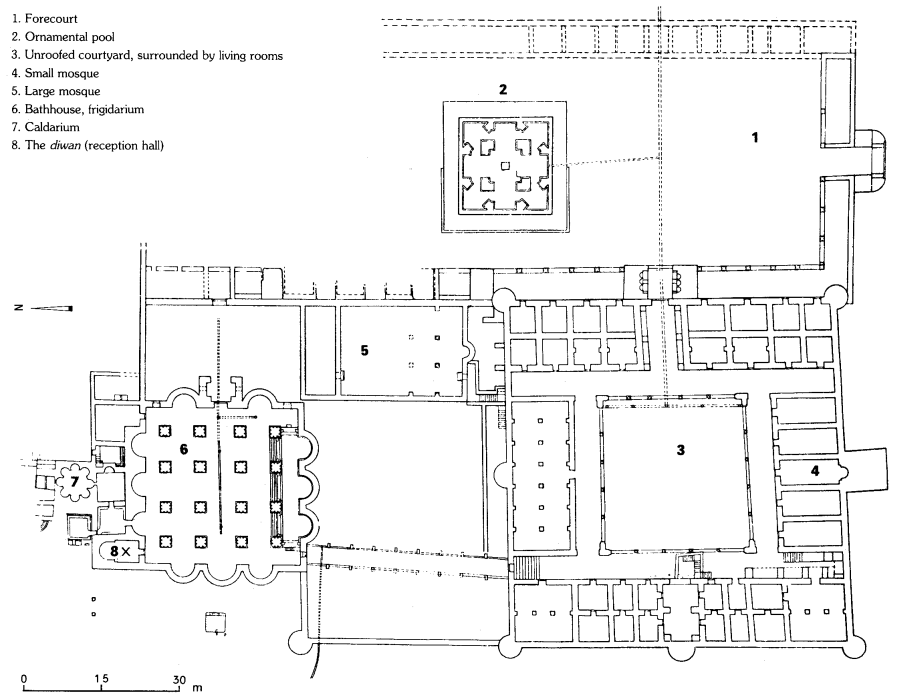
There are five parts to the establishment:
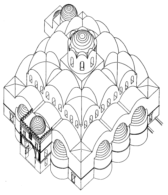
- Two-storied square castle. Roughly 70 m to the side, the complex has a porticoed courtyard with single rooms, large halls, or apartments known in Arabic as bayts, around it (see figure 1) ; although their exact functions cannot be established, these halls clearly were meant for a diverse set of activities, a relative rarity in palaces of the same type. The entrance complex is unusually large and was decorated with a striking array of stucco sculptures, ranging from traditional geometric and vegetal designs to an unusual number of representations of personages and animals, and mural paintings, some representational, on the second floor.
- Mosque. To the north of the castle, a small and architecturally sober mosque had a direct passage to the second floor of the living quarter.
- Bath. A sequence of rooms — an enormous (30 X 30 m) common room covered by an extraordinary roof of vaults and domes, a small suite of bathing rooms, a large latrine, a heavily decorated small private room, and a monumental entrance — corresponds to the usual system that issued from Roman architecture. The respective sizes of the components and especially the decoration found in them are unique in three ways: by the techniques used (mosaics, paintings, and sculptures); by the subjects depicted (princes, half-clad women, animals in all sorts of guises, a most elaborate geometry, rich vegetation), even though many of the topics have not yet been properly identified; and by the styles of depiction (its models are found in the Mediterranean world as well as in Buddhist Central Asia). A small room in the northwest corner, whose exact function is unclear, is a museum of mosaic and sculpture masterpieces.
- Forecourt. Unifying the bath, mosque, and castle as a single composition, even though they were built at different times, is a forecourt. Toward the center of the courtyard an octagonal domed pavilion stood over a small pool.
- Walled and irrigated area. A large walled and irrigated area surrounding the complex may have been used for cultivation or for hunting.
- Fig. 1 - Aerial View of "Hisham's Palace"
from Meyers et. al. (1997)
Figure 1
General view of the excavated palace
Courtesy Pictorial Archive
Meyers et. al. (1997) - "Hisham's Palace" in Google Earth
 "Hisham's Palace"
click on image to explore this site on a new tab in Google Earth - "Hisham's Palace" on govmap.gov.il
"Hisham's Palace"
click on image to explore this site on a new tab in govmap.gov.il
- Location Map from Stern et. al. (1993 v.2)
 Map of the main sites at Jericho and its environs, Roman-Byzantine period.
Stern et. al. (1993 v.2) - Fig. 1 - Map of the Dead Sea
fault system in the Jericho Valley from Alfonsi et al (2013)
 Fig. 1
Geodynamic setting (inset) and schematic map of the Dead Sea fault system in the Jericho Valley. Macroseismic intensity of the 1033 A.D. earthquake occurred in the Khirbet area (data from Guidoboni and Comastri, 2005). Location of the archaeological site and of main fault traces is reported. The white square delimits the area shown in Figure 6.
Alfonsi et al (2013) - Fig. 6 - Structural sketch map
and stress-field configuration of Hisham's Palace and surroundings from Alfonsi et al (2013)
 Fig. 6
Structural sketch map and stress-field configuration in the Hisham palace surroundings
Red line and arrows represent the coseismic rupture and slip related to the 1033 A.D. event inferred from this study
data from Hofstetter et al, 2007 and Lazar et al, 2006
Alfonsi et al (2013)
- Plan of Hisham's Palace
from Stern et. al. (1993 v.3)
 Khirbet el-Majjar: plan of the site.
Stern et. al. (1993 v.3) - Fig. 2 - Plan of Hisham's Palace
from Whitcomb (1988)
 Figure 2
Plan of the palace of Khirbet al-Mafjar, after Barakmi 1942b, fig. 1
Whitcomb (1988) - Fig. 2d - Map of the surveyed
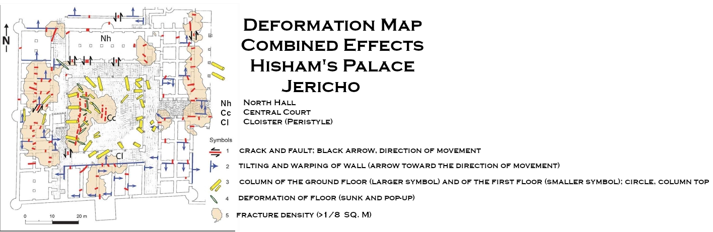
coseismic effects at Hisham's palace from Alfonsi et al (2013)
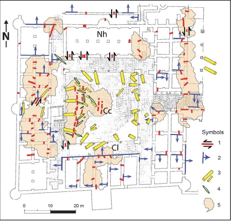 Fig. 2d
Map of the surveyed coseismic effects at Hisham palace (Khirbet al-Mafjar site)
- Nh - North hall
- Cc - Central court
- Cl - Cloister
- crack and fault; black arrow, direction of movement
- tilting and warping of wall (arrow toward the direction of movement)
- column of the ground floor (larger symbol) and of the first floor (smaller symbol); circle, column top
- deformation of floor (sunk and pop-up)
- fracture density (>1/8 m2)
Original plan of the palace is modified from Hamilton (1959)
Alfonsi et al (2013) - Fig. 3 - Plan of "Hisham's Palace"
with distribution of structural damage from Karcz and Kafri (1981)
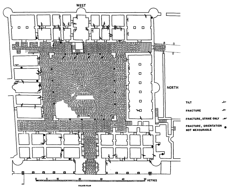 Fig. 3
Detailed plan of the palace precinct and the distribution of structural damage
Karcz and Kafri (1981) - Fig. 12 - Plan of "Hisham's Palace"
with interpreted left-lateral shear from Reches and Hoexter (1981)
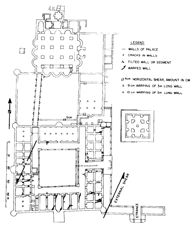 Fig. 12
Map of the Hisham Palace close to Jericho (location 3, Fig. lc). The heavy lines indicate the main damage to the palace walls mapped in the present study. Most of the damage features are consistent with left-lateral shear parallel to the two marked solid arrows
Base map after Hamilton (1959).
Reches and Hoexter (1981)
- Plan of Hisham's Palace
from Stern et. al. (1993 v.3)
Khirbet el-Majjar: plan of the site.
Stern et. al. (1993 v.3) - Fig. 2 - Plan of Hisham's Palace
from Whitcomb (1988)
Figure 2
Plan of the palace of Khirbet al-Mafjar, after Barakmi 1942b, fig. 1
Whitcomb (1988) - Fig. 2d - Map of the surveyed
coseismic effects at Hisham's palace from Alfonsi et al (2013)
Fig. 2d
Map of the surveyed coseismic effects at Hisham palace (Khirbet al-Mafjar site)
- Nh - North hall
- Cc - Central court
- Cl - Cloister
- crack and fault; black arrow, direction of movement
- tilting and warping of wall (arrow toward the direction of movement)
- column of the ground floor (larger symbol) and of the first floor (smaller symbol); circle, column top
- deformation of floor (sunk and pop-up)
- fracture density (>1/8 m2)
Original plan of the palace is modified from Hamilton (1959)
Alfonsi et al (2013) - Fig. 3 - Plan of "Hisham's Palace"
with distribution of structural damage from Karcz and Kafri (1981)
Fig. 3
Detailed plan of the palace precinct and the distribution of structural damage
Karcz and Kafri (1981) - Fig. 12 - Plan of "Hisham's Palace"
with interpreted left-lateral shear from Reches and Hoexter (1981)
Fig. 12
Map of the Hisham Palace close to Jericho (location 3, Fig. lc). The heavy lines indicate the main damage to the palace walls mapped in the present study. Most of the damage features are consistent with left-lateral shear parallel to the two marked solid arrows
Base map after Hamilton (1959).
Reches and Hoexter (1981)
- Reconstruction of the bath
from Stern et. al. (1993 v.3)
 Reconstruction of the bath.
Stern et. al. (1993 v.3)
- from Taha (2011)
- Plan of Hisham's Palace
from Stern et. al. (1993 v.3)
Khirbet el-Majjar: plan of the site.
Stern et. al. (1993 v.3) - Reconstruction of the bath
from Stern et. al. (1993 v.3)
Reconstruction of the bath.
Stern et. al. (1993 v.3) - Fig. 9 - View of Squares I and II
from Taha (2011)
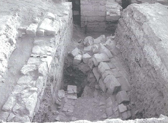 Fig. 9
Khirbet el-Mafjar: general view of squares I, II.
Taha (2011)
| Strata | Date | Notes |
|---|---|---|
| I |
topsoil layer (represented by locus 1 in square I and locus 1 in square II) covers the whole area of excavations. It is ca. I5-35 cm in thickness and consists of soft, loose soil mixed with pottery sherds. It is a layer of dark brown soil mixed with small and medium sized stones. A complete lamp was found in the south-eastern corner of square II. The debris is mixed with pottery sherds and glass fragments. Below that, there was a layer of ash mixed with stones, represented by loci 2 in squares I and II. A further stratum consists of a layer of lime, ca. 15-50 cm in thickness, and it was represented by locus 3 in squares I and II. Below the lime layer is another layer consisting of loci 8, 10 and 11 in square I, and loci 5 and 10 in square II. This stratum includes a layer of scattered stones represented by locus 9 in square I and locus 4 in square II. |
|
| II |
this stratum features the last major architectural phase in the history of the complex. It is represented by the walls W.6 and W.7 in square I and wall W.5a in square II. Wall W.5a features a secondary use of the palace stones. It was built above an earlier wall, dating most probably to the Umayyad Period. It is the same wall of the hot room and furnace. The new wall took the same north-south direction. But the construction techniques differ remarkably. Part of the wall was built on earth, projecting ca. 10 cm. The secondary nature of the wall is indicated by the use of carved stones for the earlier period, as well as using the tile fragments in filling the wall. The size of the stone ranges between 30 to 56 cm, two courses of the wall were preserved, with an average height of 26 cm, and 66-57 cm in width. The wall continues in the southern and northern directions. The wall can be associated with the room corner in square I (loci 6 and 7). Against the wall a layer of rubble and small stones, 10-16 cm in thickness (L.11) contains fragments of pottery and glass. In the same level, locus 10 consists of a stone pavement, 10 cm in thickness. The two loci 10 and 11 represent the living surfaces of this occupational period. |
|
| III |
period of abandonment represented by locus 7 in square I and loci 8 and 9 of square II. Another layer of light brownish soil above the layer of falling tile was represented by L.12 in square I. This layer of debris is mixed with large quantities of lime fragments of the plaster casting the tile roof and the surrounding wall, as well as fragment of tile and stones of different sizes. This layer covers the whole excavated area, and is about 70 cm in thickness. It contains pottery sherds, glass fragments, animal bones and an iron ring. |
|
| IV |
a layer of falling tile represented by locus 14 of square I and locus 13 in square II. It features evidence of the earthquake which struck the site. This dramatic moment in the history of the site is represented by a heavy layer of accumulation of fallen roof tile (50 cm in thickness) covering the whole area. The average size of the tile is 33 x 33 cm, and 25 x 25 cm, and 5 cm in thickness. The red coloured tile was made of rough clay mixed with straw and small stones as a temper. The tile bears different signs, indicating probably a sort of production signs, including simple incisions, wavy lines, imprints, net designs and in one case an Arabic inscription. In certain cases, foot imprints were indicated, as well as imprints of mosaic pavements. These signs could give some valuable information about production and processing of building material during the Umayyad Period. It is evident from the large bulks of tile, with a layer of mortar 2-4 cm in between, that it was used for roofing domes and building arches. An example is visible in the furnace area, with the beginning of a springing arch. However, a thick layer of plaster (5 cm) was indicated by a large fragment of white plaster found associated with this layer of destruction, 2.5 cm in thickness, mixed with soil, ash and charcoal. |
|
| V |
burnt layer below the falling tile, represented by locus 15 in square I and locus 14 in square II. A small area was excavated in the south-east corner of the square. This layer represents the period of use of the bath, connected with the activities of burning and firing wood. |
|
| VI |
this layer is represented by the earliest architectural elements in this area, represented by the eastern wall, W.5a in square I, the earthen surface, L.15 and the collapsed pilaster in the western part of square I. The fallen pilaster was built of ashlar stones, and it was a free standing column, falling to the north direction, partly over the falling tile L.14. The pilaster was built of four courses of ashlar stones; one stone bears engraved decorations. The thickness of these courses ranges between 24-40 cm, and the stone pilaster was capped with a stone, triangular in shape, indicating a beginning of a springing arch. It is on the same line of the arch on the other side of the furnace, indicating that the area was roofed. |
| Effect | Location | Image(s) | Description |
|---|---|---|---|
|
Hisham's Paalace
Figure 2 Plan of the palace of Khirbet al-Mafjar, after Barakmi 1942b, fig. 1 Whitcomb (1988) |
"Ceramics of this period occurred on or near the floor amid destruction debris, fallen columns, and stone elements and tended to occupy a stratum of about 40 cm." - Whitcomb (1988:63) |
| Effect | Location | Image(s) | Description |
|---|---|---|---|
|
Central Court and elsewhere
Figure 2 Plan of the palace of Khirbet al-Mafjar, after Barakmi 1942b, fig. 1 Whitcomb (1988)
Fig. 2dMap of the surveyed coseismic effects at Hisham palace (Khirbet al-Mafjar site)
Original plan of the palace is modified from Hamilton (1959) Alfonsi et al (2013) |
Fig. 3a  Fig. 3a
View of the central court from the south: white arrows,fracture alignments along the pavement structure; black arrows,debris lying under the collapsed columns. Widespread tumbles and column failures are exposed. Alfonsi et al (2013) |
The direction of column failure is due to the traction effect of the first-floor collapse.- Alfonsi et al (2013) |
|
east—west bearing walls
Figure 2 Plan of the palace of Khirbet al-Mafjar, after Barakmi 1942b, fig. 1 Whitcomb (1988)
Fig. 2dMap of the surveyed coseismic effects at Hisham palace (Khirbet al-Mafjar site)
Original plan of the palace is modified from Hamilton (1959) Alfonsi et al (2013) |
Fig. 4b - east-west bearing wall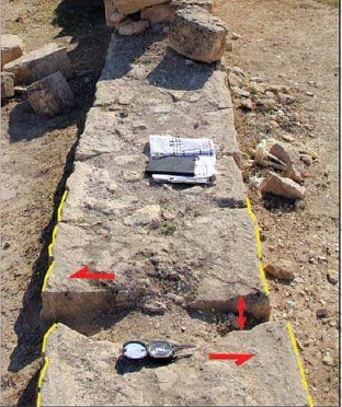 Fig. 4b
Mixed Mode I—II (open-shear) fracture of an east—west-striking bearing wall (view from west). Note by JW: In Fracture Mechanics Mode I = Opening mode (a tensile stress normal to the plane of the crack) and Mode II = Sliding mode (a shear stress acting parallel to the plane of the crack and perpendicular to the crack front). Alfonsi et al (2013) 4a - east—west bearing wall of the North hall  Figure 4a
Closely spaced faults with 10 cm left-lateral slips crossing the east—west-oriented bearing wall of the North hall (view from southeast). Alfonsi et al (2013) |
Some structures with mixed shear (sinistral)-opening mode have also been recognized (Fig.4b).- Alfonsi et al (2013) |
|
various locations
Figure 2 Plan of the palace of Khirbet al-Mafjar, after Barakmi 1942b, fig. 1 Whitcomb (1988)
Fig. 2dMap of the surveyed coseismic effects at Hisham palace (Khirbet al-Mafjar site)
Original plan of the palace is modified from Hamilton (1959) Alfonsi et al (2013) |
Fig. 3b  Fig. 3b
Tilted bearing wall a meter wide, the black arrow indicates the direction of inertial wall movement (view from northwest). Alfonsi et al (2013)  Fig. 7b
Tilted Walls Karcz and Kafri (1981) |
Several walls are tilted and/or warped up to 15° (Figs. 2 and 3b).- Alfonsi et al (2013) |
|
Room IVa - a room facing the east cloister
Figure 2 Plan of the palace of Khirbet al-Mafjar, after Barakmi 1942b, fig. 1 Whitcomb (1988)
Fig. 2dMap of the surveyed coseismic effects at Hisham palace (Khirbet al-Mafjar site)
Original plan of the palace is modified from Hamilton (1959) Alfonsi et al (2013) |
 Plate XXXV.2
Fallen arch in Room IVa Baramki (1938)  Plate XXXV.3
Fallen arch in Room IVa Baramki (1938) 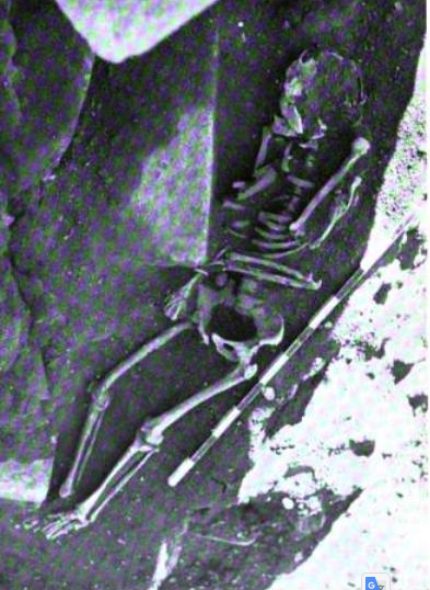 Plate XXXV.4
Skeleton under debris of fallen arch in Room IVa Baramki (1938) |
A human skeleton found in a room facing the east cloister under debris of an arch that collapsed in 1000-1400 A.D. could be also indicative of seismic shaking (Baramki, 1938).- Alfonsi et al (2013) |
|
Central Court and Cloisters
Figure 2 Plan of the palace of Khirbet al-Mafjar, after Barakmi 1942b, fig. 1 Whitcomb (1988)
Fig. 2dMap of the surveyed coseismic effects at Hisham palace (Khirbet al-Mafjar site)
Original plan of the palace is modified from Hamilton (1959) Alfonsi et al (2013) |
 Fig. 7f
Fractures across the western part of the central court Karcz and Kafri (1981)  Fig. 6c
Misalignments in flagstone pavements, no signs of distortion, crushing nor overriding Karcz and Kafri (1981) |
The flagstones are deformed in a pop-up-like array.- Alfonsi et al (2013) |
|
north wall of an archaeological trench 50 m north of the north hall area |
Fig. 4c
 Fig. 4c
Part of a 6 m wide shear zone consisting of > 50° dipping north—south-striking fractures and faults (in red) outcropping on the north wall of an archaeological trench. Blue lines allow the eye to identify the displaced flood-related deposits. View from south. Alfonsi et al (2013) |
Fifty meters north of the north hall area, we observed a 6 m wide shear zone consisting of high-angle fractures and faults exposed on the northern wall of an archaeological trench (Fig. 4c) The vertical displacement across this zone is of the order of tens of centimeters. No data are available to strictly constraint the age of faulting.- Alfonsi et al (2013) |
|
Drainage channel in the northern section of the site |
Fig. 5
 Figure 5
Drainage channel in the northern section of the site affected by fracturing closely aligned with the shear zone outcropping along the northern trench edge (view from southeast). Alfonsi et al (2013) |
Drainage channel in the northern section of the site affected by fracturing closely aligned with the shear zone outcropping along the northern trench edge- Alfonsi et al (2013) |
- There is more archaeoseismic evidence in Baramki's Excavation Reports
| Effect | Image(s) | Source |
|---|---|---|
| Misalignments in flagstone pavements no signs of distortion, crushing nor overriding |
 Fig. 6a
Misalignments in flagstone pavements, no signs of distortion, crushing nor overriding Karcz and Kafri (1981)  Fig. 6b
Misalignments in flagstone pavements, no signs of distortion, crushing nor overriding Karcz and Kafri (1981)
Fig. 6cMisalignments in flagstone pavements, no signs of distortion, crushing nor overriding Karcz and Kafri (1981) |
Karcz and Kafri (1981) |
| Gap between Walls |
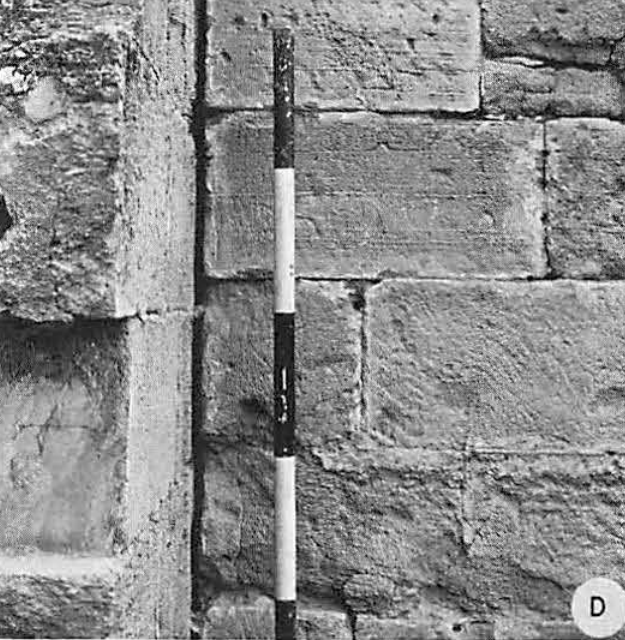 Fig. 6d
A joint-like gap between the outer wall and a partition wall Karcz and Kafri (1981) |
Karcz and Kafri (1981) |
| Impact Fractures |
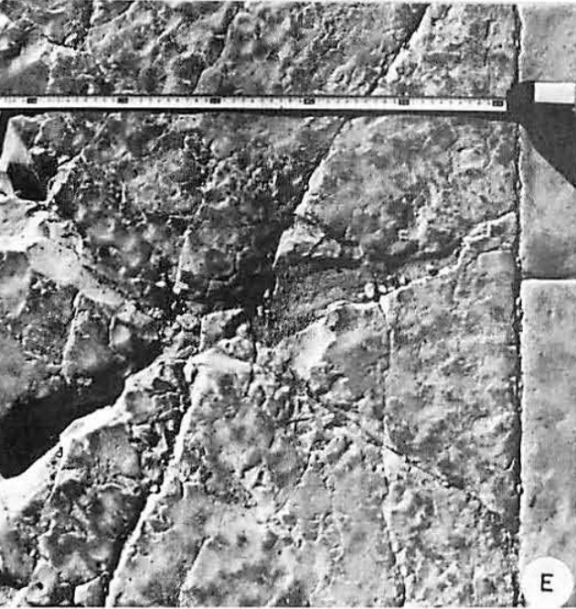 Fig. 6e
Features of impact Karcz and Kafri (1981) |
Karcz and Kafri (1981) |
| suture between remnant and rebuilt wall |
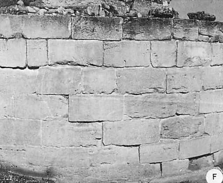 Fig. 6f
A suture between the remnant and rebuilt wall. Karcz and Kafri (1981) |
Karcz and Kafri (1981) |
| Tilted Walls |
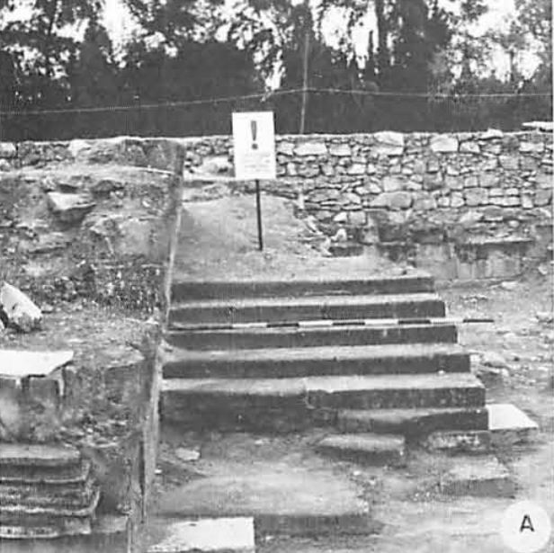 Fig. 7a
Tilted Walls Karcz and Kafri (1981)
Fig. 7bTilted Walls Karcz and Kafri (1981) |
Karcz and Kafri (1981) |
| Collapse Debris |
 Fig. 7c
Remnant of collapse debris Karcz and Kafri (1981)  Plate LXXV.2
Bricks in debris at west end of Hall I Baramki (1936) |
Karcz and Kafri (1981) and Baramki (1936) |
| Fractured Walls |
 Fig. 7d
Fractures in the palace walls. Karcz and Kafri (1981)  Fig. 7e
Fractures in the palace walls. Karcz and Kafri (1981) |
Karcz and Kafri (1981) |
| Fractured Floors |
Fig. 7f Fractures across the western part of the central court Karcz and Kafri (1981) |
Karcz and Kafri (1981) |
| Fractured Wall Repairs |
 Fig. 7g
Fractures and fissures, apparently repaired in course of reconstruction Karcz and Kafri (1981) |
Karcz and Kafri (1981) |
| Severely fractured Doorway |
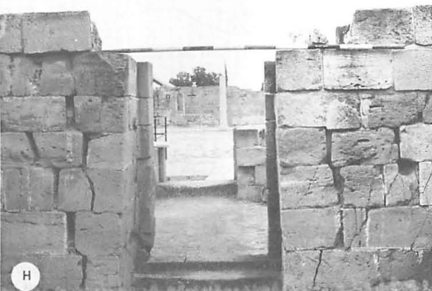 Fig. 7h
Fractures near a through walk, inclined towards the sill Karcz and Kafri (1981) |
Karcz and Kafri (1981) |
| Distorted and Blocked Doorway |
 Fig. 7i
A throughwalk , blocked during a later occupancy, with signs of deformation. Karcz and Kafri (1981) |
Karcz and Kafri (1981) |
| Fractured Walls |
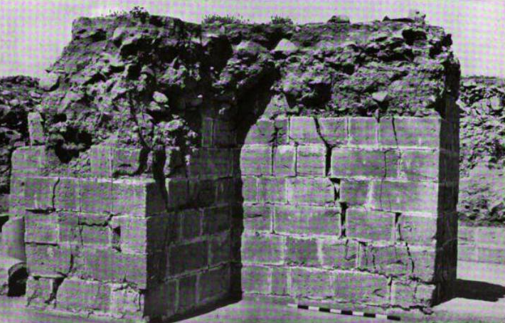 Plate LXXIV.2
Pier (iv) Hall I, showing effects of earthquake Baramki (1936) 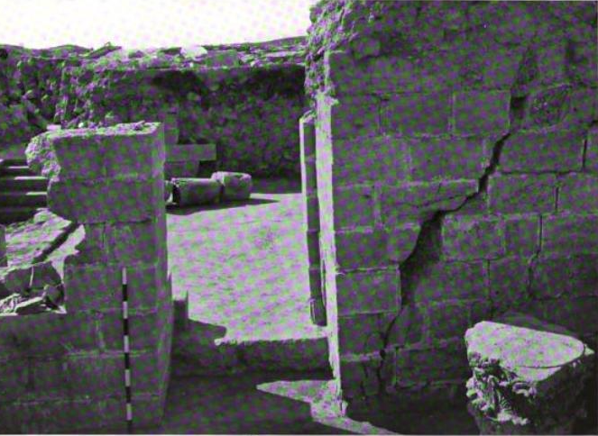 Plate LXXXII.2
Door between Room a and hall Baramki (1936) |
Baramki (1936) |
| Fallen Arch |
Plate XXXV.2 Fallen arch in Room IVa Baramki (1938)
Plate XXXV.3Fallen arch in Room IVa Baramki (1938)
Plate XXXV.4Skeleton under debris of fallen arch in Room IVa Baramki (1938) |
Baramki (1938) |
| Orientation of fractures and tilted walls |
 Fig. 8
Orientation of fractures and tilted walls, palace precinct. Karcz and Kafri (1981) |
Karcz and Kafri (1981) |
Fig. 2dMap of the surveyed coseismic effects at Hisham palace (Khirbet al-Mafjar site)
- Nh - North hall
- Cc - Central court
- Cl - Cloister
- crack and fault; black arrow, direction of movement
- tilting and warping of wall (arrow toward the direction of movement)
- column of the ground floor (larger symbol) and of the first floor (smaller symbol); circle, column top
- deformation of floor (sunk and pop-up)
- fracture density (>1/8 m2)
Original plan of the palace is modified from Hamilton (1959)
Alfonsi et al (2013)
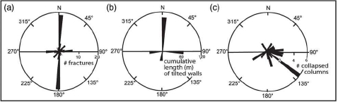 Figure 2 a-c
Rose diagrams of
(a) strike of fractures
(b) direction of tilting versus cumulative length of titled walls
(c) direction of column collapse.
Alfonsi et al (2013)
Alfonsi et al (2013) documented and measured orientations of archeoseismic damage such as tilted structures, displaced walls and pavements, and colonnade failure. By combining their their field work (70%) with previous studies (30%) by Karcz and Kafri, 1981 and Reches and Hoexter, 1981 they were able to produce an array of useful archeoseismic data. They describe the archeoseismic evidence below:
The observed damage defines a severe earthquake scenario. Most of the brittle structures affect the supporting and divisor walls ( Figs. 2, 4a
Map of the surveyed coseismic effects at Hisham palace (Khirbet al-Mafjar site)
- Nh - North hall
- Cc - Central court
- Cl - Cloister
- crack and fault; black arrow, direction of movement
- tilting and warping of wall (arrow toward the direction of movement)
- column of the ground floor (larger symbol) and of the first floor (smaller symbol); circle, column top
- deformation of floor (sunk and pop-up)
- fracture density (>1/8 m2)
Original plan of the palace is modified from Hamilton (1959)
Alfonsi et al (2013)and 4b
Closely spaced faults with 10 cm left-lateral slips crossing the east—west-oriented bearing wall of the North hall (view from southeast).
Alfonsi et al (2013)). These structures are faults and open cracks with dip generally > 50° and width up to 20 cm. The faults offset archaeological structures with left-lateral slips up to 10 cm. Some structures with mixed shear (sinistral)-opening mode have also been recognized ( Fig.4b
Mixed Mode I—II (open-shear) fracture of an east—west-striking bearing wall (view from west).
Note by JW: In Fracture Mechanics Mode I = Opening mode (a tensile stress normal to the plane of the crack) and Mode II = Sliding mode (a shear stress acting parallel to the plane of the crack and perpendicular to the crack front).
Alfonsi et al (2013)). In the western portion of the pavement of the central court, roughly north—south striking cracks and vertical deformations occur ( Fig. 3
Mixed Mode I—II (open-shear) fracture of an east—west-striking bearing wall (view from west).
Note by JW: In Fracture Mechanics Mode I = Opening mode (a tensile stress normal to the plane of the crack) and Mode II = Sliding mode (a shear stress acting parallel to the plane of the crack and perpendicular to the crack front).
Alfonsi et al (2013)). The flagstones are deformed in a pop-up-like array. These deformations have a linear continuity of about 30 m and align to the faults and shear-opening structures affecting the walls of the north and south cloister ( Fig. 2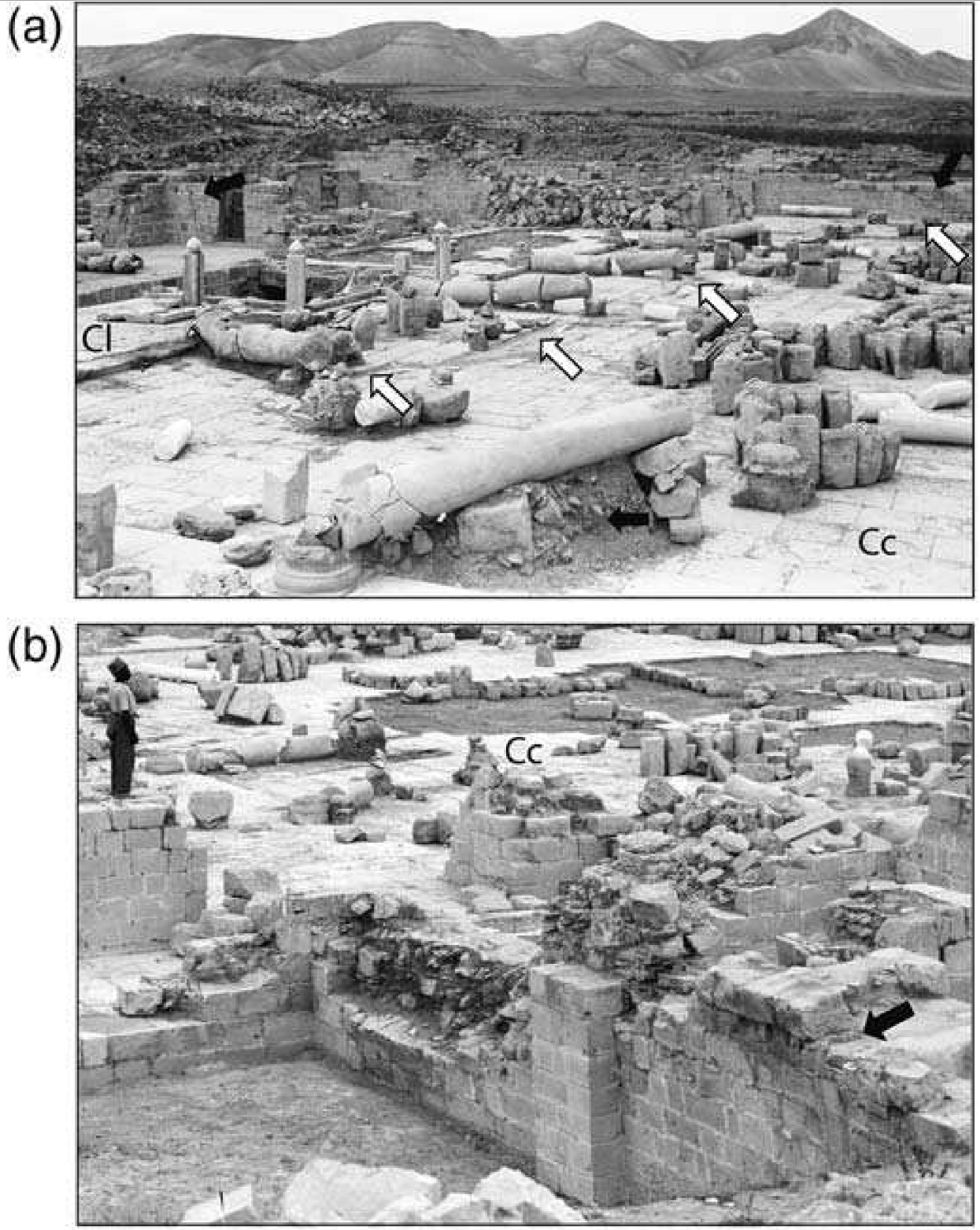
Pictures from Matson and Matson (1934-1939) showing the ruins of the palace as appeared during Baramki excavation
- View of the central court from the south: white arrows, fracture alignments along the pavement structure; black arrows, debris lying under the collapsed columns. Widespread tumbles and column failures are exposed.
- Tilted bearing wall a meter wide, the black arrow indicates the direction of inertial wall movement (view from northwest)
Alfonsi et al (2013)). The fractures at Hisham palace have a preferred north—south strike and a second-order east—west strike (Rose diagram in Fig. 2a
Map of the surveyed coseismic effects at Hisham palace (Khirbet al-Mafjar site)
- Nh - North hall
- Cc - Central court
- Cl - Cloister
- crack and fault; black arrow, direction of movement
- tilting and warping of wall (arrow toward the direction of movement)
- column of the ground floor (larger symbol) and of the first floor (smaller symbol); circle, column top
- deformation of floor (sunk and pop-up)
- fracture density (>1/8 m2)
Original plan of the palace is modified from Hamilton (1959)
Alfonsi et al (2013)). Fracture density (shaded pale orange areas in Fig. 2d
Rose diagram of strike of fractures
Alfonsi et al (2013)) evidences two roughly north—south elongated subparallel areas located on the western side of Hisham palace, and one, also north—south elongated, on the eastern side. Fifty meters north of the north hall area, we observed a 6 m wide shear zone consisting of high-angle fractures and faults exposed on the northern wall of an archaeological trench ( Fig. 4c
Map of the surveyed coseismic effects at Hisham palace (Khirbet al-Mafjar site)
- Nh - North hall
- Cc - Central court
- Cl - Cloister
- crack and fault; black arrow, direction of movement
- tilting and warping of wall (arrow toward the direction of movement)
- column of the ground floor (larger symbol) and of the first floor (smaller symbol); circle, column top
- deformation of floor (sunk and pop-up)
- fracture density (>1/8 m2)
Original plan of the palace is modified from Hamilton (1959)
Alfonsi et al (2013)) The vertical displacement across this zone is of the order of tens of centimeters. No data are available to strictly constraint the age of faulting. The plaster and the drainage channel close to the trench wall are affected by fracturing aligned with the deformed zone ( Fig. 5
Part of a 6 m wide shear zone consisting of >50° dipping north—south-striking fractures and faults (in red) outcropping on the north wall of an archaeological trench. Blue lines allow the eye to identify the displaced flood-related deposits. View from south.
Alfonsi et al (2013)).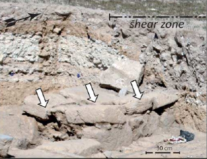
Drainage channel in the northern section of the site affected by fracturing closely aligned with the shear zone outcropping along the northern trench edge (view from southeast).
Alfonsi et al (2013)
Several walls are tilted and/or warped up to 15° ( Figs. 2and 3b
Map of the surveyed coseismic effects at Hisham palace (Khirbet al-Mafjar site)
- Nh - North hall
- Cc - Central court
- Cl - Cloister
- crack and fault; black arrow, direction of movement
- tilting and warping of wall (arrow toward the direction of movement)
- column of the ground floor (larger symbol) and of the first floor (smaller symbol); circle, column top
- deformation of floor (sunk and pop-up)
- fracture density (>1/8 m2)
Original plan of the palace is modified from Hamilton (1959)
Alfonsi et al (2013)). Rose diagram in Figure 2b
Tilted bearing wall a meter wide, the black arrow indicates the direction of inertial wall movement (view from northwest).
Alfonsi et al (2013)shows the cumulative length of tilting, for which the preferred sense is north. The occurrence of this preferred sense of tilting confirms the seismic nature of the observed damage (Paz (1997)). A human skeleton found in a room facing the east cloister under debris of an arch that collapsed in 1000-1400 A.D. could be also indicative of seismic shaking (Baramki, 1938).
Rose diagram of direction of tilting versus cumulative length of titled walls
Alfonsi et al (2013)
The overall position of the failed columns has been reconstructed from original reports and pictures and it is reported in Figure 2. Most colonnade collapses cluster mainly toward the southeastern quadrant (Rose diagram in Fig. 2c
Map of the surveyed coseismic effects at Hisham palace (Khirbet al-Mafjar site)
- Nh - North hall
- Cc - Central court
- Cl - Cloister
- crack and fault; black arrow, direction of movement
- tilting and warping of wall (arrow toward the direction of movement)
- column of the ground floor (larger symbol) and of the first floor (smaller symbol); circle, column top
- deformation of floor (sunk and pop-up)
- fracture density (>1/8 m2)
Original plan of the palace is modified from Hamilton (1959)
Alfonsi et al (2013)). The direction of column failure is due to the traction effect of the first-floor collapse.
Rose diagram of direction of column collapse.
Alfonsi et al (2013)
- Slightly Modified by JW from from Alfonsi et al (2013)
Map of the surveyed coseismic effects at Hisham palace (Khirbet al-Mafjar site)
- Nh - North hall
- Cc - Central court
- Cl - Cloister
- crack and fault; black arrow, direction of movement
- tilting and warping of wall (arrow toward the direction of movement)
- column of the ground floor (larger symbol) and of the first floor (smaller symbol); circle, column top
- deformation of floor (sunk and pop-up)
- fracture density (>1/8 m2)
Modified by JW from Fig. 2d of Alfonsi et al. (2013)
Original plan of the palace is modified by Alfonsi from Hamilton (1959)
Click on Image to open in a new tab
Figure 2 a-cRose diagrams of
(a) strike of fractures
(b) direction of tilting versus cumulative length of titled walls
(c) direction of column collapse.
Alfonsi et al (2013)
Fig. 3Detailed plan of the palace precinct and the distribution of structural damage
Karcz and Kafri (1981)
Fig. 8Orientation of fractures and tilted walls, palace precinct.
Karcz and Kafri (1981)
Fig. 12Map of the Hisham Palace close to Jericho (location 3, Fig. lc). The heavy lines indicate the main damage to the palace walls mapped in the present study. Most of the damage features are consistent with left-lateral shear parallel to the two marked solid arrows
Base map after Hamilton (1959).
Reches and Hoexter (1981)
- Earthquake Archeological Effects chart
of Rodríguez-Pascua et al (2013: 221-224)
 Earthquake Archeological Effects (EAE)
Rodríguez-Pascua et al (2013: 221-224)
| Effect | Location | Image(s) | Description | Intensity |
|---|---|---|---|---|
|
Hisham's Paalace
Figure 2 Plan of the palace of Khirbet al-Mafjar, after Barakmi 1942b, fig. 1 Whitcomb (1988) |
"Ceramics of this period occurred on or near the floor amid destruction debris, fallen columns, and stone elements and tended to occupy a stratum of about 40 cm." - Whitcomb (1988:63) |
|
-
Earthquake Archeological Effects chart
of Rodríguez-Pascua et al (2013: 221-224)
Earthquake Archeological Effects (EAE)
Rodríguez-Pascua et al (2013: 221-224)
| Effect | Location | Image(s) | Description | Intensity |
|---|---|---|---|---|
|
Central Court and elsewhere
Figure 2 Plan of the palace of Khirbet al-Mafjar, after Barakmi 1942b, fig. 1 Whitcomb (1988)
Fig. 2dMap of the surveyed coseismic effects at Hisham palace (Khirbet al-Mafjar site)
Original plan of the palace is modified from Hamilton (1959) Alfonsi et al (2013) |
Fig. 3a
Fig. 3a View of the central court from the south: white arrows,fracture alignments along the pavement structure; black arrows,debris lying under the collapsed columns. Widespread tumbles and column failures are exposed. Alfonsi et al (2013) |
The direction of column failure is due to the traction effect of the first-floor collapse.- Alfonsi et al (2013) |
|
|
east—west bearing walls
Figure 2 Plan of the palace of Khirbet al-Mafjar, after Barakmi 1942b, fig. 1 Whitcomb (1988)
Fig. 2dMap of the surveyed coseismic effects at Hisham palace (Khirbet al-Mafjar site)
Original plan of the palace is modified from Hamilton (1959) Alfonsi et al (2013) |
Fig. 4b - east-west bearing wall
Fig. 4b Mixed Mode I—II (open-shear) fracture of an east—west-striking bearing wall (view from west). Note by JW: In Fracture Mechanics Mode I = Opening mode (a tensile stress normal to the plane of the crack) and Mode II = Sliding mode (a shear stress acting parallel to the plane of the crack and perpendicular to the crack front). Alfonsi et al (2013) 4a - east—west bearing wall of the North hall
Figure 4aClosely spaced faults with 10 cm left-lateral slips crossing the east—west-oriented bearing wall of the North hall (view from southeast). Alfonsi et al (2013) |
Some structures with mixed shear (sinistral)-opening mode have also been recognized (Fig.4b).- Alfonsi et al (2013) |
|
|
various locations
Figure 2 Plan of the palace of Khirbet al-Mafjar, after Barakmi 1942b, fig. 1 Whitcomb (1988)
Fig. 2dMap of the surveyed coseismic effects at Hisham palace (Khirbet al-Mafjar site)
Original plan of the palace is modified from Hamilton (1959) Alfonsi et al (2013) |
Fig. 3b
Fig. 3b Tilted bearing wall a meter wide, the black arrow indicates the direction of inertial wall movement (view from northwest). Alfonsi et al (2013)
Fig. 7bTilted Walls Karcz and Kafri (1981) |
Several walls are tilted and/or warped up to 15° (Figs. 2 and 3b).- Alfonsi et al (2013) |
|
|
Room IVa - a room facing the east cloister
Figure 2 Plan of the palace of Khirbet al-Mafjar, after Barakmi 1942b, fig. 1 Whitcomb (1988)
Fig. 2dMap of the surveyed coseismic effects at Hisham palace (Khirbet al-Mafjar site)
Original plan of the palace is modified from Hamilton (1959) Alfonsi et al (2013) |
Plate XXXV.2 Fallen arch in Room IVa Baramki (1938)
Plate XXXV.3Fallen arch in Room IVa Baramki (1938)
Plate XXXV.4Skeleton under debris of fallen arch in Room IVa Baramki (1938) |
A human skeleton found in a room facing the east cloister under debris of an arch that collapsed in 1000-1400 A.D. could be also indicative of seismic shaking (Baramki, 1938).- Alfonsi et al (2013) |
|
|
Central Court and Cloisters
Figure 2 Plan of the palace of Khirbet al-Mafjar, after Barakmi 1942b, fig. 1 Whitcomb (1988)
Fig. 2dMap of the surveyed coseismic effects at Hisham palace (Khirbet al-Mafjar site)
Original plan of the palace is modified from Hamilton (1959) Alfonsi et al (2013) |
Fig. 7f Fractures across the western part of the central court Karcz and Kafri (1981)
Fig. 6cMisalignments in flagstone pavements, no signs of distortion, crushing nor overriding Karcz and Kafri (1981) |
The flagstones are deformed in a pop-up-like array.- Alfonsi et al (2013) |
|
|
north wall of an archaeological trench 50 m north of the north hall area |
Fig. 4c
Fig. 4c Part of a 6 m wide shear zone consisting of > 50° dipping north—south-striking fractures and faults (in red) outcropping on the north wall of an archaeological trench. Blue lines allow the eye to identify the displaced flood-related deposits. View from south. Alfonsi et al (2013) |
Fifty meters north of the north hall area, we observed a 6 m wide shear zone consisting of high-angle fractures and faults exposed on the northern wall of an archaeological trench (Fig. 4c) The vertical displacement across this zone is of the order of tens of centimeters. No data are available to strictly constraint the age of faulting.- Alfonsi et al (2013) |
|
|
Drainage channel in the northern section of the site |
Fig. 5
Figure 5 Drainage channel in the northern section of the site affected by fracturing closely aligned with the shear zone outcropping along the northern trench edge (view from southeast). Alfonsi et al (2013) |
Drainage channel in the northern section of the site affected by fracturing closely aligned with the shear zone outcropping along the northern trench edge- Alfonsi et al (2013) |
|
- Fig. 6 - Structural sketch map
and stress-field configuration of Hisham's Palace and surroundings from Alfonsi et al (2013)
Fig. 6
Structural sketch map and stress-field configuration in the Hisham palace surroundings
Red line and arrows represent the coseismic rupture and slip related to the 1033 A.D. event inferred from this study
data from Hofstetter et al, 2007 and Lazar et al, 2006
Alfonsi et al (2013)
Alfonsi et al (2013) discussed the seismotectonic implications of the archeoseismic data unearthed from Hisham's Palace as follows:
The preferred sense of tilting of the Hisham walls and the colonnade-collapse direction indicate, according to structural dynamic models by Paz (1997) and Hinzen (2009) on inelastic inertial structures, a ground shaking by seismic waves coming from the northern quadrant. Although the cause of most of the earthquake-induced damage at Hisham palace is ground shaking, some of the mapped features have a clear tectonic origin. These features include the occurrence ofAll these data define a syn- and post-1033 A.D. brittle deformation zone. This zone may represent the southern prolongation of the north—south-striking, subvertical fault recognized by field and seismic data (Fig. 6). This fault accommodates the deepening of the Jericho syntectonic sedimentary basin. The prevailing left-lateral slips we recognize at Hisham palace along north—south- to north-northeast—south-southwest-striking structures are fully compatible with the strike-slip stress regime of the Jordan area of the Dead Sea fault system, which is characterized by a northwest—southeast subhorizontal σ1 (Fig. 6; Hofstetter et. al., 2007). As a result, we conclude that the 1033 A.D. earthquake originated within this stress field.
- left-lateral faults
- north—south- to north-northeast—south-southwest-striking fractures and cracks
- aligned fractures up to 30 m long crossing the whole palace formed during the 1033 A.D. earthquake
- a 6 m wide north—south- to north-northeast—south-southwest-striking shear zone affecting the ground.