Jerusalem - City Walls
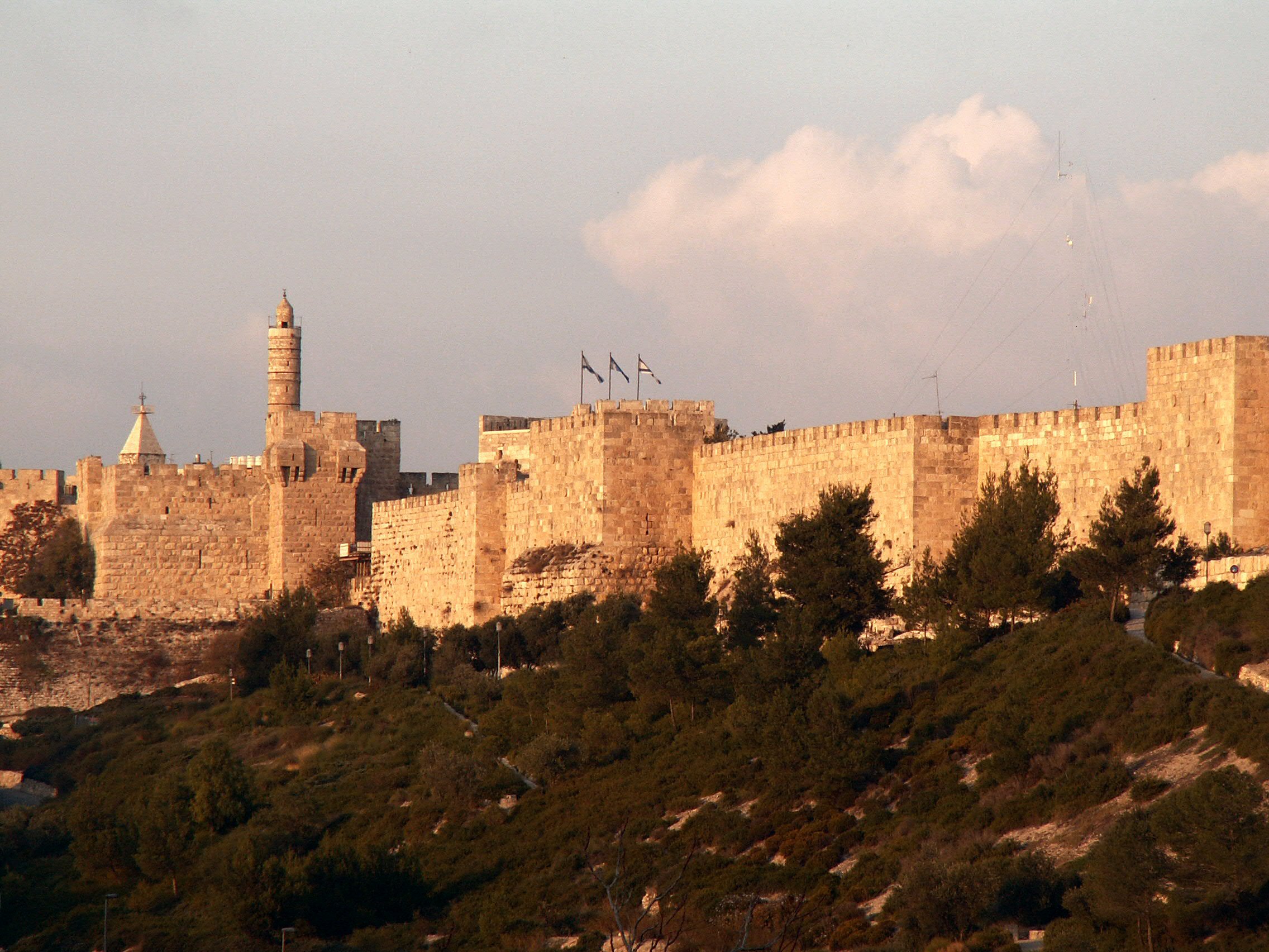 Ottoman Walls surrounding the Old City in Jerusalem
Eitan F. on Wikipedia - Public Domain
- Jerusalem Old City in Google Earth
 Jerusalem Old City
click on image to explore this site on a new tab in Google Earth - Jerusalem Old City on govmap.gov.il
 Jerusalem Old City
click on image to explore this site on a new tab in govmap.gov.il
- Fig. 2 - Roman-Byzantine city walls
and exposures from Weksler-Bdolah in Galor and Avni (2011:421)
 Fig. 2.
The Roman-Byzantine city wall (after Tsafrir 2000, Weksler-Bdolah 2006-7). Dots mark places where segments of the Roman-Byzantine wall were exposed.
Weksler-Bdolah in Galor and Avni (2011) - Fig. 15 The Early
Byzantine city wall where dots mark exposed segments and recent finds from Asutay-Effenberger and Weksler-Bdolah (2022)
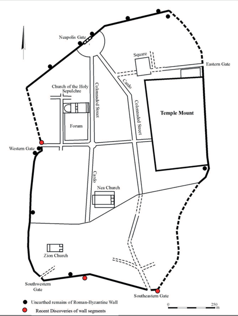 Fig. 15
The Early Byzantine city wall. Dots mark places where segments of the wall were exposed, red dots are recent excavation finds. After Tsafrir 2000, drawing by Natalya Zak, courtesy of the Israel Antiquities Authority.
Click on image to open a magnifiable image in a new tab
Asutay-Effenberger and Weksler-Bdolah (2022) - Fig. 5 - Jerusalem’s city walls
from the Early Islamic period to the Ottoman period from Weksler-Bdolah in Galor and Avni (2011)
 Fig. 5
Jerusalem’s city walls from the Early Islamic period to the Ottoman period (after Seligman 2001 and Weksler-Bdolah 2011).
Weksler-Bdolah in Galor and Avni (2011) - Fig. 21 - Jerusalem’s city walls
the Roman–Byzantine, Early Islamic, Crusader/Ayyubid, and Ottoman periods from Weksler-Bdolah in Galor and Avni (2011)
 Fig. 21
Jerusalem’s city walls in the Roman–Byzantine, Early Islamic, Crusader/Ayyubid, and Ottoman periods
Weksler-Bdolah in Galor and Avni (2011)
- Fig. 2 - Roman-Byzantine
city walls and exposures from Weksler-Bdolah in Galor and Avni (2011:421)
Fig. 2.
The Roman-Byzantine city wall (after Tsafrir 2000, Weksler-Bdolah 2006-7). Dots mark places where segments of the Roman-Byzantine wall were exposed.
Weksler-Bdolah in Galor and Avni (2011) - Fig. 15 The Early
Byzantine city wall where dots mark exposed segments and recent finds from Asutay-Effenberger and Weksler-Bdolah (2022)
Fig. 15
The Early Byzantine city wall. Dots mark places where segments of the wall were exposed, red dots are recent excavation finds. After Tsafrir 2000, drawing by Natalya Zak, courtesy of the Israel Antiquities Authority.
Click on image to open a magnifiable image in a new tab
Asutay-Effenberger and Weksler-Bdolah (2022) - Fig. 5 - Jerusalem’s city walls
from the Early Islamic period to the Ottoman period from Weksler-Bdolah in Galor and Avni (2011)
Fig. 5
Jerusalem’s city walls from the Early Islamic period to the Ottoman period (after Seligman 2001 and Weksler-Bdolah 2011).
Weksler-Bdolah in Galor and Avni (2011) - Fig. 21 - Jerusalem’s city walls
the Roman–Byzantine, Early Islamic, Crusader/Ayyubid, and Ottoman periods from Weksler-Bdolah in Galor and Avni (2011)
Fig. 21
Jerusalem’s city walls in the Roman–Byzantine, Early Islamic, Crusader/Ayyubid, and Ottoman periods
Weksler-Bdolah in Galor and Avni (2011)
- Fig. 1 - Plan of north wall
of the Old City of Jerusalem from Hamilton (1944)
 Fig. 1
Plan of north wall of the Old City of Jerusalem, showing the location of the areas excavated by Hamilton. In 1937-38, Hamilton conducted excavations in five areas along the north wall. Sounding A, located against the western face of the western tower at the Damascus Gate, provided the most substantial and valuable sequence.
Figure caption from Magness (1991)
Hamilton (1944)
- Fig. 1 - Plan of north wall
of the Old City of Jerusalem from Hamilton (1944)
Fig. 1
Plan of north wall of the Old City of Jerusalem, showing the location of the areas excavated by Hamilton. In 1937-38, Hamilton conducted excavations in five areas along the north wall. Sounding A, located against the western face of the western tower at the Damascus Gate, provided the most substantial and valuable sequence.
Figure caption from Magness (1991)
Hamilton (1944)
- Herod’s Gate area: Map
showing excavation areas from Stern et al (2008)
 Herod’s Gate area: map showing excavation areas
Stern et al (2008)
- Herod’s Gate area: Map
showing excavation areas from Stern et al (2008)
Herod’s Gate area: map showing excavation areas
Stern et al (2008)
- Fig. 16 The Early
Byzantine wall near Damascus Gate from Asutay-Effenberger and Weksler-Bdolah (2022)
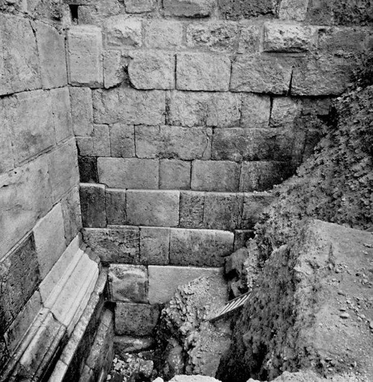 Fig. 16
The Early Byzantine wall near Damascus Gate. After Hamilton 1944, Pl. 1.1.
Click on image to open a magnifiable image in a new tab
Asutay-Effenberger and Weksler-Bdolah (2022) - Fig. 17 Late Roman
wall cut by the corner of the SE tower of the Byzantine Wall from Asutay-Effenberger and Weksler-Bdolah (2022)
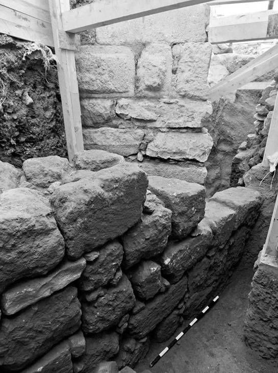 Fig. 17
Late Roman wall cut by the corner of the SE tower of the Byzantine Wall. Looking north, after Weksler-Bdolah and Lavi 2012.
Click on image to open a magnifiable image in a new tab
Asutay-Effenberger and Weksler-Bdolah (2022) - Fig. 18 Corner of SE
tower of the Byzantine Wall, looking north from Asutay-Effenberger and Weksler-Bdolah (2022)
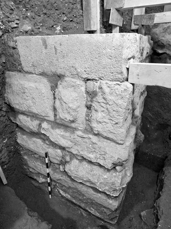 Fig. 18
Corner of the SE tower of the Byzantine Wall. Looking north, after Weksler-Bdolah and Lavi 2012.
Click on image to open a magnifiable image in a new tab
Asutay-Effenberger and Weksler-Bdolah (2022) - Fig. 19 The Early
Byzantine wall in the Ophel excavations from Asutay-Effenberger and Weksler-Bdolah (2022)
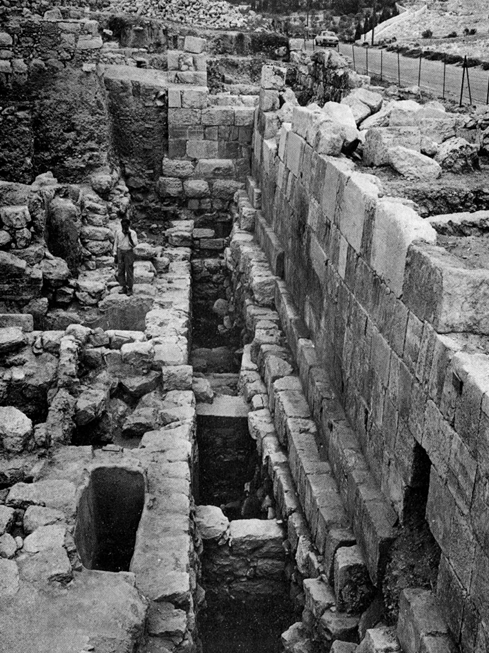 Fig. 19
The Early Byzantine wall in the Ophel excavations. Looking north, after Mazar 2007, Fig. 17.14.
Click on image to open a magnifiable image in a new tab
Asutay-Effenberger and Weksler-Bdolah (2022)
- Fig. 2 - Roman-Byzantine city walls
and exposures from Weksler-Bdolah in Galor and Avni (2011:421)
Fig. 2.
The Roman-Byzantine city wall (after Tsafrir 2000, Weksler-Bdolah 2006-7). Dots mark places where segments of the Roman-Byzantine wall were exposed.
Weksler-Bdolah in Galor and Avni (2011) - Fig. 1 - Plan of north wall
of the Old City of Jerusalem from Hamilton (1944)
Fig. 1
Plan of north wall of the Old City of Jerusalem, showing the location of the areas excavated by Hamilton. In 1937-38, Hamilton conducted excavations in five areas along the north wall. Sounding A, located against the western face of the western tower at the Damascus Gate, provided the most substantial and valuable sequence.
Figure caption from Magness (1991)
Hamilton (1944)
- Fig. 2 - Roman-Byzantine city walls and exposures
from Weksler-Bdolah in Galor and Avni (2011:421)
Fig. 2.
The Roman-Byzantine city wall (after Tsafrir 2000, Weksler-Bdolah 2006-7). Dots mark places where segments of the Roman-Byzantine wall were exposed.
Weksler-Bdolah in Galor and Avni (2011) - Fig. 5 - Jerusalem’s city walls from the Early Islamic period
to the Ottoman period from Weksler-Bdolah in Galor and Avni (2011)
Fig. 5
Jerusalem’s city walls from the Early Islamic period to the Ottoman period (after Seligman 2001 and Weksler-Bdolah 2011).
Weksler-Bdolah in Galor and Avni (2011) - Fig. 21 - Jerusalem’s city walls the Roman–Byzantine,
Early Islamic, Crusader/Ayyubid, and Ottoman periods from Weksler-Bdolah in Galor and Avni (2011)
Fig. 21
Jerusalem’s city walls in the Roman–Byzantine, Early Islamic, Crusader/Ayyubid, and Ottoman periods
Weksler-Bdolah in Galor and Avni (2011) - Fig. 1 - Plan of north wall of the Old City of Jerusalem
from Hamilton (1944)
Fig. 1
Plan of north wall of the Old City of Jerusalem, showing the location of the areas excavated by Hamilton. In 1937-38, Hamilton conducted excavations in five areas along the north wall. Sounding A, located against the western face of the western tower at the Damascus Gate, provided the most substantial and valuable sequence.
Figure caption from Magness (1991)
Hamilton (1944) - Herod’s Gate area: map showing excavation areas
from Stern et al (2008)
Herod’s Gate area: map showing excavation areas
Stern et al (2008)
| Effect | Location | Image(s) | Description |
|---|---|---|---|
|
Jerusalem Map of the Old City and its environs; numbers refer to excavation sites discussed in the text
Stern et al (2008) |
|
| Effect | Location | Image(s) | Description |
|---|---|---|---|
|
near the Mosque of Omar and near an unnamed Mosque
Map of the Old City and its environs; numbers refer to excavation sites discussed in the text Stern et al (2008) |
|
| Effect | Location | Image(s) | Description |
|---|---|---|---|
|
Various locations
Fig. 2. The Roman-Byzantine city wall (after Tsafrir 2000, Weksler-Bdolah 2006-7). Dots mark places where segments of the Roman-Byzantine wall were exposed. Weksler-Bdolah in Galor and Avni (2011) city walls near the Damascus Gate
Fig. 1Plan of north wall of the Old City of Jerusalem, showing the location of the areas excavated by Hamilton. In 1937-38, Hamilton conducted excavations in five areas along the north wall. Sounding A, located against the western face of the western tower at the Damascus Gate, provided the most substantial and valuable sequence. Figure caption from Magness (1991) Hamilton (1944) southwest corner of the city walls in the Armenian Garden
Fig. 2. The Roman-Byzantine city wall (after Tsafrir 2000, Weksler-Bdolah 2006-7). Dots mark places where segments of the Roman-Byzantine wall were exposed. Weksler-Bdolah in Galor and Avni (2011) |
|
- Earthquake Archeological Effects chart
of Rodríguez-Pascua et al (2013: 221-224)
 Earthquake Archeological Effects (EAE)
Rodríguez-Pascua et al (2013: 221-224)
| Effect | Location | Image(s) | Description | Intensity |
|---|---|---|---|---|
|
Jerusalem
Map of the Old City and its environs; numbers refer to excavation sites discussed in the text Stern et al (2008) |
|
|
- Earthquake Archeological Effects chart
of Rodríguez-Pascua et al (2013: 221-224)
Earthquake Archeological Effects (EAE)
Rodríguez-Pascua et al (2013: 221-224)
| Effect | Location | Image(s) | Description | Intensity |
|---|---|---|---|---|
|
near the Mosque of Omar and near an unnamed Mosque
Map of the Old City and its environs; numbers refer to excavation sites discussed in the text Stern et al (2008) |
|
|
-
Earthquake Archeological Effects chart
of Rodríguez-Pascua et al (2013: 221-224)
Earthquake Archeological Effects (EAE)
Rodríguez-Pascua et al (2013: 221-224)
| Effect | Location | Image(s) | Description | Intensity |
|---|---|---|---|---|
|
Various locations |
|
|
-
Earthquake Archeological Effects chart
of Rodríguez-Pascua et al (2013: 221-224)
Earthquake Archeological Effects (EAE)
Rodríguez-Pascua et al (2013: 221-224)
| Effect | Location | Image(s) | Description | Intensity |
|---|---|---|---|---|
|
Various locations
Fig. 2. The Roman-Byzantine city wall (after Tsafrir 2000, Weksler-Bdolah 2006-7). Dots mark places where segments of the Roman-Byzantine wall were exposed. Weksler-Bdolah in Galor and Avni (2011) city walls near the Damascus Gate
Fig. 1Plan of north wall of the Old City of Jerusalem, showing the location of the areas excavated by Hamilton. In 1937-38, Hamilton conducted excavations in five areas along the north wall. Sounding A, located against the western face of the western tower at the Damascus Gate, provided the most substantial and valuable sequence. Figure caption from Magness (1991) Hamilton (1944) southwest corner of the city walls in the Armenian Garden
Fig. 2. The Roman-Byzantine city wall (after Tsafrir 2000, Weksler-Bdolah 2006-7). Dots mark places where segments of the Roman-Byzantine wall were exposed. Weksler-Bdolah in Galor and Avni (2011) |
|
|
-
Earthquake Archeological Effects chart
of Rodríguez-Pascua et al (2013: 221-224)
Earthquake Archeological Effects (EAE)
Rodríguez-Pascua et al (2013: 221-224)
| Effect | Location | Image(s) | Description | Intensity |
|---|---|---|---|---|
|
Various locations |
|
|