Khirbat Faris
 Khirbat Faris (upper left) and
Khirbat Tadun (mound to lower right) in Google Earth
Khirbat Faris (upper left) and
Khirbat Tadun (mound to lower right) in Google Earthclick on image to explore this site on a new tab in Google Earth
- Fig. 1.4 - Location Map
from McQuitty et al. (2020)
 Figure 1.4
Plan of the Kerak Plateau
click on image to open in a new tab
McQuitty et al. (2020)
- Fig. 1.4 - Location Map
from McQuitty et al. (2020)
Figure 1.4
Plan of the Kerak Plateau
click on image to open in a new tab
McQuitty et al. (2020)
- Fig. 1.3 - Aerial View of
Khirbat Faris (left) and Khirbat Tadun (mound in lower right) from McQuitty et al. (2020)
 Figure 1.3
Aerial view
Khirbat Faris is to the left of the road
Khirbat Tadun is to the right of the road. It is the mound in the middle right of the photo
click on image to open in a new tab
McQuitty et al. (2020)
APAAME_20070417
_DLK-0051 © David L. Kennedy, Aerial Photographic Archive for Archaeology in the Middle East. - Khirbat Faris (upper left)
and Khirbat Tadun (mound to lower right) in Google Earth
Khirbat Faris (upper left) and
Khirbat Tadun (mound to lower right) in Google Earth
click on image to explore this site on a new tab in Google Earth
- Fig. 1.2 - Site plan
from McQuitty et al. (2020)
 Figure 1.2
Area plan around Khirbat Faris
click on image to open in a new tab
McQuitty et al. (2020) - Fig. 2.1 - Site Plan
from McQuitty et al. (2020)
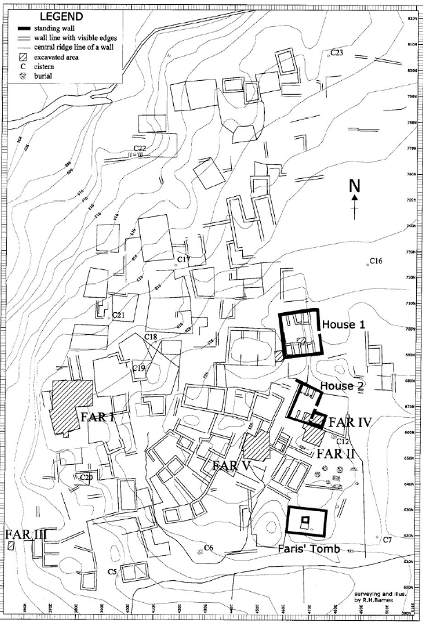 Figure 2.1
Site plan of Khirbat Faris
click on image to open in a new tab
McQuitty et al. (2020)
- Fig. 1.2 - Site plan
from McQuitty et al. (2020)
Figure 1.2
Area plan around Khirbat Faris
click on image to open in a new tab
McQuitty et al. (2020) - Fig. 2.1 - Site Plan
from McQuitty et al. (2020)
Figure 2.1
Site plan of Khirbat Faris
click on image to open in a new tab
McQuitty et al. (2020)
- Fig. 5.19 - Phase 3.1
plan from McQuitty et al. (2020)
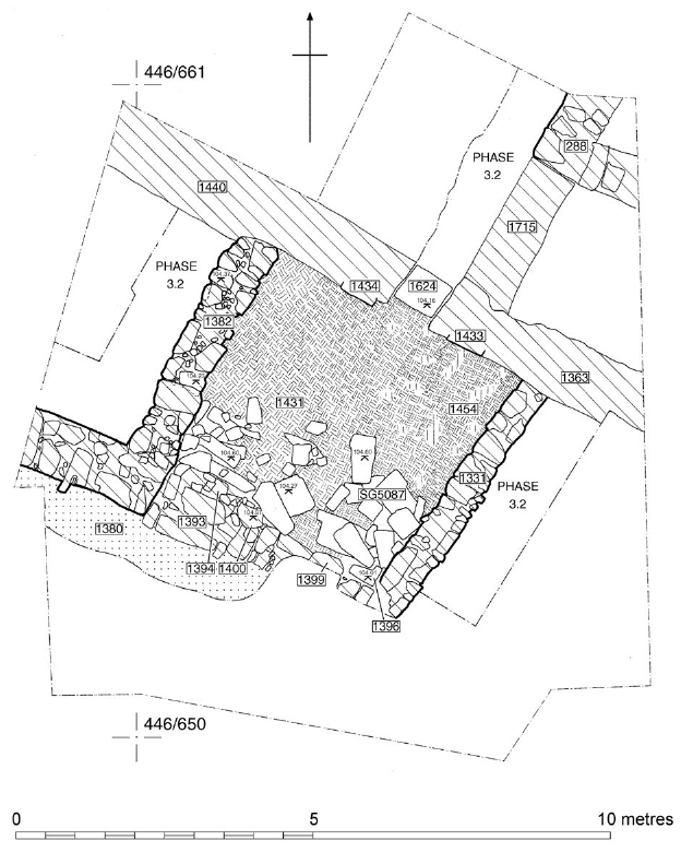 Figure 5.19
Phase 3.1 plan the foreground
click on image to open in a new tab
McQuitty et al. (2020) - Fig. 5.28 - Phase 7
plan from McQuitty et al. (2020)
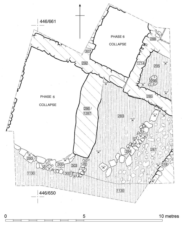 Figure 5.28
Phase 7 plan the foreground
click on image to open in a new tab
McQuitty et al. (2020)
- Fig. 5.19 - Phase 3.1
plan from McQuitty et al. (2020)
Figure 5.19
Phase 3.1 plan the foreground
click on image to open in a new tab
McQuitty et al. (2020) - Fig. 5.28 - Phase 7
plan from McQuitty et al. (2020)
Figure 5.28
Phase 7 plan the foreground
click on image to open in a new tab
McQuitty et al. (2020)
- Fig. 4.12 - Phase 3.1
plan for Far II from McQuitty et al. (2020)
 Figure 4.12
Phase 3.1 plan the foreground
click on image to open in a new tab
McQuitty et al. (2020) - Fig. 4.20 - Phase 3.2
plan for Far II from McQuitty et al. (2020)
 Figure 4.20
Phase 3.2 plan the foreground
click on image to open in a new tab
McQuitty et al. (2020)
- Fig. 4.12 - Phase 3.1
plan for Far II from McQuitty et al. (2020)
Figure 4.12
Phase 3.1 plan the foreground
click on image to open in a new tab
McQuitty et al. (2020) - Fig. 4.20 - Phase 3.2
plan for Far II from McQuitty et al. (2020)
Figure 4.20
Phase 3.2 plan the foreground
click on image to open in a new tab
McQuitty et al. (2020)
- Fig. 6.18 - Plan of House
1 and its trenches from McQuitty et al. (2020)
 Figure 6.18
Plan of House 1 and its trenches
click on image to open in a new tab
McQuitty et al. (2020)
- Fig. 6.18 - Plan of House
1 and its trenches from McQuitty et al. (2020)
Figure 6.18
Plan of House 1 and its trenches
click on image to open in a new tab
McQuitty et al. (2020)
- Fig. 2.13 - The Western Edge
(Far I) from McQuitty et al. (2020)
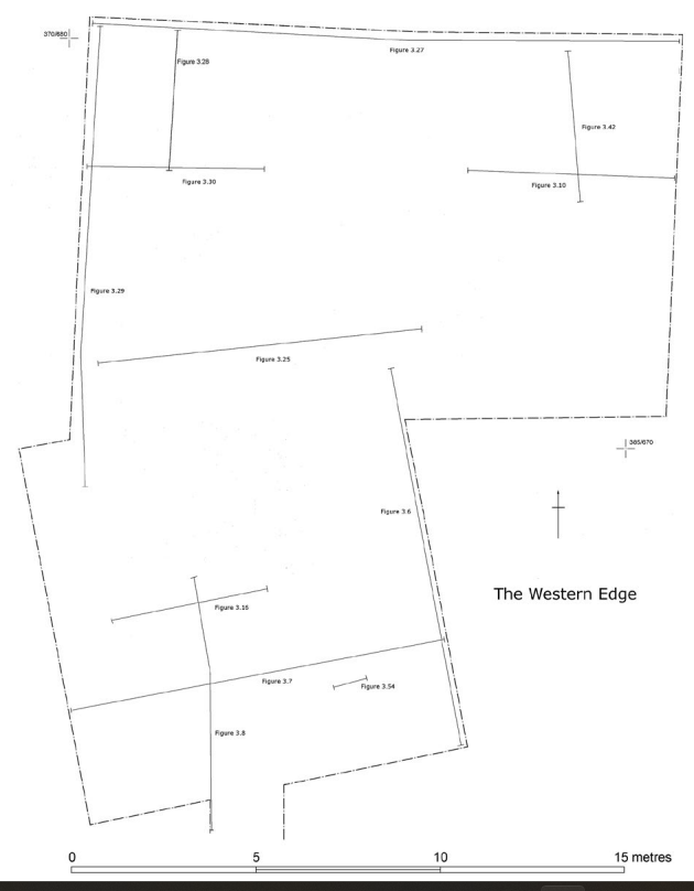 Figure 2.13
The Western Edge (Far I): location of sections
click on image to open in a new tab
McQuitty et al. (2020) - Fig. 2.14 - The Central Area
(Far II and Far IV) from McQuitty et al. (2020)
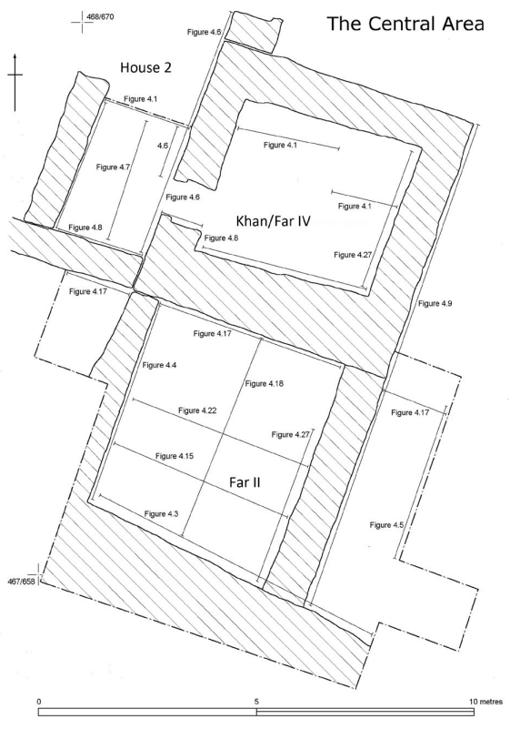 Figure 2.14
The Central Area (Far II and Far IV): location of sections
click on image to open in a new tab
McQuitty et al. (2020) - Fig. 2.15 - The Highest
Point (Far V) from McQuitty et al. (2020)
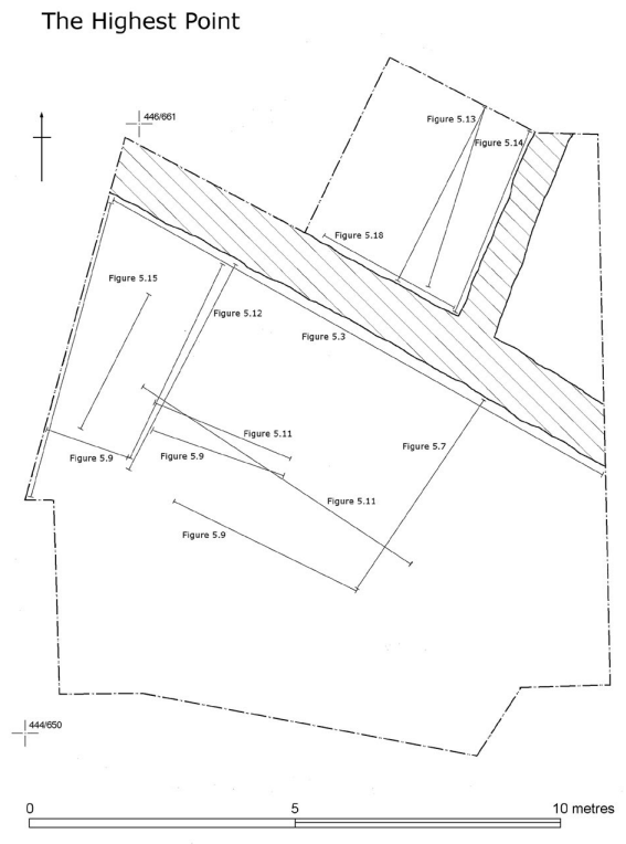 Figure 2.15
The Highest Point (Far V): location of sections
click on image to open in a new tab
McQuitty et al. (2020) - Fig. 2.16 - House 1
from McQuitty et al. (2020)
 Figure 2.16
House 1: location of sections
click on image to open in a new tab
McQuitty et al. (2020)
- Fig. 2.13 - The Western Edge
(Far I) from McQuitty et al. (2020)
Figure 2.13
The Western Edge (Far I): location of sections
click on image to open in a new tab
McQuitty et al. (2020) - Fig. 2.14 - The Central Area
(Far II and Far IV) from McQuitty et al. (2020)
Figure 2.14
The Central Area (Far II and Far IV): location of sections
click on image to open in a new tab
McQuitty et al. (2020) - Fig. 2.15 - The Highest
Point (Far V) from McQuitty et al. (2020)
Figure 2.15
The Highest Point (Far V): location of sections
click on image to open in a new tab
McQuitty et al. (2020) - Fig. 2.16 - House 1
from McQuitty et al. (2020)
Figure 2.16
House 1: location of sections
click on image to open in a new tab
McQuitty et al. (2020)
- Fig. 4.5 - East baulk
of the Far II trench from McQuitty et al. (2020)
 Figure 4.5
East baulk of the Far II trench
click on image to open in a new tab
McQuitty et al. (2020) - Fig. 4.15 - East-west
section through G2003 and G2004 (Far II) showing collapsed arch from McQuitty et al. (2020)
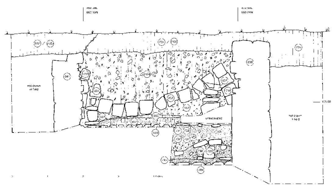 Figure 4.15
East-west section through G2003 and G2004
click on image to open in a new tab
McQuitty et al. (2020)
- Fig. 4.5 - East baulk
of the Far II trench from McQuitty et al. (2020)
Figure 4.5
East baulk of the Far II trench
click on image to open in a new tab
McQuitty et al. (2020) - Fig. 4.15 - East-west
section through G2003 and G2004 (Far II) showing collapsed arch from McQuitty et al. (2020)
Figure 4.15
East-west section through G2003 and G2004
click on image to open in a new tab
McQuitty et al. (2020)
- Fig. 4.28 - Reconstruction
drawing of a Late Antique House based on Far II from McQuitty et al. (2020)
 Figure 4.28
Reconstruction drawing of a Late Antique House based on Far II
click on image to open in a new tab
McQuitty et al. (2020) - Fig. 10.7 - Classical
Vault from McQuitty et al. (2020)
 Figure 10.7
The Classical Vault
click on image to open in a new tab
McQuitty et al. (2020) - Fig. 10.8 - Late Antique
House from McQuitty et al. (2020)
 Figure 10.8
The Late Antique House
click on image to open in a new tab
McQuitty et al. (2020) - Fig. 10.9 - Transverse-Arch
House from McQuitty et al. (2020)
 Figure 10.9
The Transverse-Arch House
click on image to open in a new tab
McQuitty et al. (2020) - Fig. 10.17 - Barrel-vaulted
House from McQuitty et al. (2020)
 Figure 10.17
The Barrel-vaulted House
click on image to open in a new tab
McQuitty et al. (2020) - Fig. 10.21 - Arch-and-Grain-bin
House from McQuitty et al. (2020)
 Figure 10.21
The Arch-and-Grain-bin House
click on image to open in a new tab
McQuitty et al. (2020)
- Fig. 4.28 - Reconstruction
drawing of a Late Antique House based on Far II from McQuitty et al. (2020)
Figure 4.28
Reconstruction drawing of a Late Antique House based on Far II
click on image to open in a new tab
McQuitty et al. (2020) - Fig. 10.7 - Classical
Vault from McQuitty et al. (2020)
Figure 10.7
The Classical Vault
click on image to open in a new tab
McQuitty et al. (2020) - Fig. 10.8 - Late Antique
House from McQuitty et al. (2020)
Figure 10.8
The Late Antique House
click on image to open in a new tab
McQuitty et al. (2020) - Fig. 10.9 - Transverse-Arch
House from McQuitty et al. (2020)
Figure 10.9
The Transverse-Arch House
click on image to open in a new tab
McQuitty et al. (2020) - Fig. 10.17 - Barrel-vaulted
House from McQuitty et al. (2020)
Figure 10.17
The Barrel-vaulted House
click on image to open in a new tab
McQuitty et al. (2020) - Fig. 10.21 - Arch-and-Grain-bin
House from McQuitty et al. (2020)
Figure 10.21
The Arch-and-Grain-bin House
click on image to open in a new tab
McQuitty et al. (2020)
- Fig. 5.1 - Rubble collapse
in Far V from McQuitty et al. (2020)
 Figure 5.1
View in 1989 looking northeast across the trench, showing rubble collapse and emergence of wall SG5094. Stone line SG5018 can be seen in the upper right of the picture
click on image to open in a new tab
McQuitty et al. (2020) - Fig. 5.6 - Arch and roof
collapse in Far V from McQuitty et al. (2020)
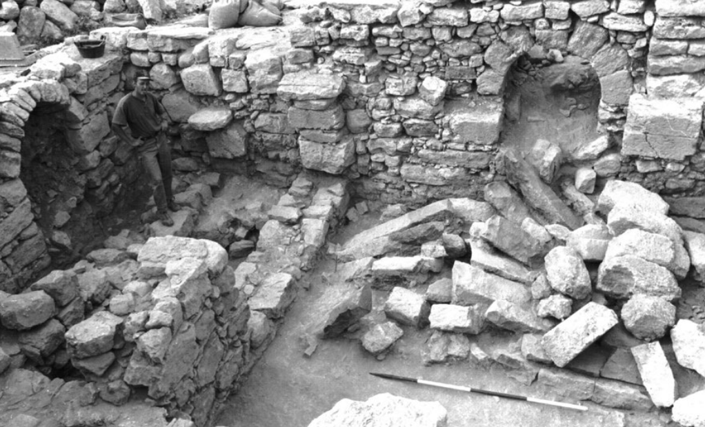 Figure 5.6
Looking north. An overview of G5002 in Phase 3 with the collapsed arches and roof rafters in the foreground. The excavator stands on the Phase 5 wall SG5064
click on image to open in a new tab
McQuitty et al. (2020) - Fig. 5.20 - Arch and roof
collapse in Far V from McQuitty et al. (2020)
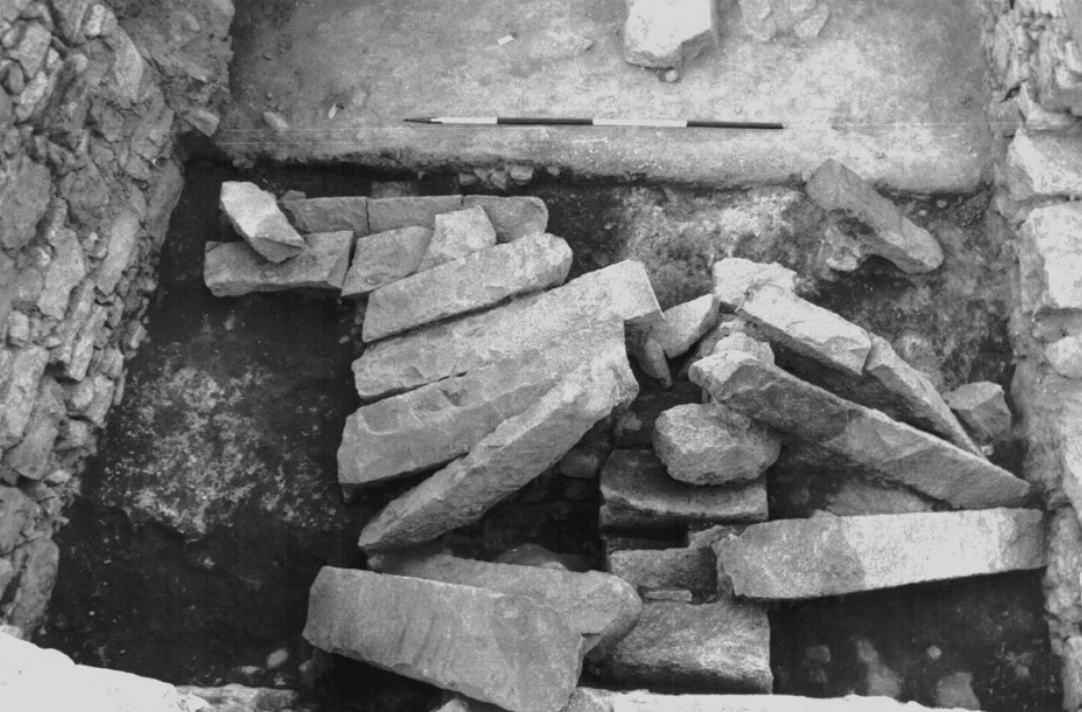 Figure 5.20
View of the collapsed western arch and roof beams SG5174. The edge of a meta can be seen under a roof-beam in the foreground
click on image to open in a new tab
McQuitty et al. (2020) - Fig. 5.23 - Phase 6 structural
rubble and roof collapse from McQuitty et al. (2020)
 Figure 5.23
Looking east at standing arch SG5092 filled with Phase 6 structural rubble and roof collapse (SG5071)
click on image to open in a new tab
McQuitty et al. (2020) - Fig. 5.24 - rubble from
McQuitty et al. (2020)
 Figure 5.24
Looking east. Wall SG5094 is in the background. To the right of the scale is the range of grain-bins with pier SG5093 in the foreground. The scale rests on surface SG5072 and to the left the arch-springer SG5142 can be seen. The rubble and line of stones in the background belong to SG5079 and SG5082 respectively
click on image to open in a new tab
McQuitty et al. (2020) - Fig. 5.25 - collapsed arch
McQuitty et al. (2020)
 Figure 5.25
Looking south at the collapsed arch SG5081 and standing arch SG5092 to the right. The ‘front’ of the grainbin walls SG5075 and SG5076 are in the background flanking SG5077. The collapsed roof-beams and arch-stones belong to SG5080
click on image to open in a new tab
McQuitty et al. (2020) - Fig. 6.16 - collapsed arch
in House 1from McQuitty et al. (2020)
 Figure 6.16
Exterior - the collapsed arch-stones of SG3014 rest on silt accumulation (SG3018)
click on image to open in a new tab
McQuitty et al. (2020) - Fig. 4.32 - collapsed arches
in Far II from McQuitty et al. (2020)
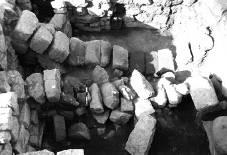 Figure 4.32
Far II. Looking south at collapsed arches SG2138 (upper) and SG2142 (lower)
click on image to open in a new tab
McQuitty et al. (2020) - Fig. 4.33 - collapsed arch
and roof rafter in Far II from McQuitty et al. (2020)
 Figure 4.33
Far II. Looking east at the collapsed southern arch, SG2138, and roof rafters
click on image to open in a new tab
McQuitty et al. (2020) - Fig. 4.35 - tilted wall
in House 2 from McQuitty et al. (2020)
 Figure 4.35
House 2. Construction of wall SG2112
click on image to open in a new tab
McQuitty et al. (2020)
- Fig. 5.1 - Rubble collapse
in Far V from McQuitty et al. (2020)
Figure 5.1
View in 1989 looking northeast across the trench, showing rubble collapse and emergence of wall SG5094. Stone line SG5018 can be seen in the upper right of the picture
click on image to open in a new tab
McQuitty et al. (2020) - Fig. 5.6 - Arch and roof
collapse in Far V from McQuitty et al. (2020)
Figure 5.6
Looking north. An overview of G5002 in Phase 3 with the collapsed arches and roof rafters in the foreground. The excavator stands on the Phase 5 wall SG5064
click on image to open in a new tab
McQuitty et al. (2020) - Fig. 5.20 - Arch and roof
collapse in Far V from McQuitty et al. (2020)
Figure 5.20
View of the collapsed western arch and roof beams SG5174. The edge of a meta can be seen under a roof-beam in the foreground
click on image to open in a new tab
McQuitty et al. (2020) - Fig. 5.23 - Phase 6 structural
rubble and roof collapse from McQuitty et al. (2020)
Figure 5.23
Looking east at standing arch SG5092 filled with Phase 6 structural rubble and roof collapse (SG5071)
click on image to open in a new tab
McQuitty et al. (2020) - Fig. 5.24 - rubble from
McQuitty et al. (2020)
Figure 5.24
Looking east. Wall SG5094 is in the background. To the right of the scale is the range of grain-bins with pier SG5093 in the foreground. The scale rests on surface SG5072 and to the left the arch-springer SG5142 can be seen. The rubble and line of stones in the background belong to SG5079 and SG5082 respectively
click on image to open in a new tab
McQuitty et al. (2020) - Fig. 5.25 - collapsed arch
McQuitty et al. (2020)
Figure 5.25
Looking south at the collapsed arch SG5081 and standing arch SG5092 to the right. The ‘front’ of the grainbin walls SG5075 and SG5076 are in the background flanking SG5077. The collapsed roof-beams and arch-stones belong to SG5080
click on image to open in a new tab
McQuitty et al. (2020) - Fig. 6.16 - collapsed arch
in House 1from McQuitty et al. (2020)
Figure 6.16
Exterior - the collapsed arch-stones of SG3014 rest on silt accumulation (SG3018)
click on image to open in a new tab
McQuitty et al. (2020) - Fig. 4.32 - collapsed arches
in Far II from McQuitty et al. (2020)
Figure 4.32
Far II. Looking south at collapsed arches SG2138 (upper) and SG2142 (lower)
click on image to open in a new tab
McQuitty et al. (2020) - Fig. 4.33 - collapsed arch
and roof rafter in Far II from McQuitty et al. (2020)
Figure 4.33
Far II. Looking east at the collapsed southern arch, SG2138, and roof rafters
click on image to open in a new tab
McQuitty et al. (2020) - Fig. 4.35 - tilted wall
in House 2 from McQuitty et al. (2020)
Figure 4.35
House 2. Construction of wall SG2112
click on image to open in a new tab
McQuitty et al. (2020)
 Table 2.1
Concordance of stratigraphic phasing across the site.
McQuitty et. al. (2020)
- Fig. 1.2 - Site plan
from McQuitty et. al. (2020)
 Figure 1.2
Area plan around Khirbat Faris
McQuitty et. al. (2020) - Fig. 2.1 - Site Plan
from McQuitty et. al. (2020)
 Figure 2.1
Site plan of Khirbat Faris
McQuitty et. al. (2020)
- Fig. 1.2 - Site plan
from McQuitty et. al. (2020)
Figure 1.2
Area plan around Khirbat Faris
McQuitty et. al. (2020) - Fig. 2.1 - Site Plan
from McQuitty et. al. (2020)
Figure 2.1
Site plan of Khirbat Faris
McQuitty et. al. (2020)
- Fig. 5.19 - Phase 3.1
plan from McQuitty et. al. (2020)
 Figure 5.19
Phase 3.1 plan the foreground.
McQuitty et. al. (2020) - Fig. 5.28 - Phase 7
plan from McQuitty et. al. (2020)
 Figure 5.28
Phase 7 plan the foreground.
McQuitty et. al. (2020)
- Fig. 5.19 - Phase 3.1
plan from McQuitty et. al. (2020)
Figure 5.19
Phase 3.1 plan the foreground.
McQuitty et. al. (2020) - Fig. 5.28 - Phase 7
plan from McQuitty et. al. (2020)
Figure 5.28
Phase 7 plan the foreground.
McQuitty et. al. (2020)
- Fig. 4.12 - Phase 3.1
plan for Far II from McQuitty et. al. (2020)
 Figure 4.12
Phase 3.1 plan the foreground.
McQuitty et. al. (2020) - Fig. 4.20 - Phase 3.2
plan for Far II from McQuitty et. al. (2020)
 Figure 4.20
Phase 3.2 plan the foreground.
McQuitty et. al. (2020)
- Fig. 4.12 - Phase 3.1
plan for Far II from McQuitty et. al. (2020)
Figure 4.12
Phase 3.1 plan the foreground.
McQuitty et. al. (2020) - Fig. 4.20 - Phase 3.2
plan for Far II from McQuitty et. al. (2020)
Figure 4.20
Phase 3.2 plan the foreground.
McQuitty et. al. (2020)
- Fig. 2.13 - The Western Edge
(Far I) from McQuitty et. al. (2020)
 Figure 2.13
The Western Edge (Far I): location of sections
McQuitty et. al. (2020) - Fig. 2.14 - The Central Area
(Far II and Far IV) from McQuitty et. al. (2020)
 Figure 2.14
The Central Area (Far II and Far IV): location of sections
McQuitty et. al. (2020) - Fig. 2.15 - The Highest
Point (Far V) from McQuitty et. al. (2020)
 Figure 2.15
The Highest Point (Far V): location of sections
McQuitty et. al. (2020) - Fig. 2.16 - House 1
from McQuitty et. al. (2020)
 Figure 2.16
House 1: location of sections
McQuitty et. al. (2020)
- Fig. 2.13 - The Western Edge
(Far I) from McQuitty et. al. (2020)
Figure 2.13
The Western Edge (Far I): location of sections
McQuitty et. al. (2020) - Fig. 2.14 - The Central Area
(Far II and Far IV) from McQuitty et. al. (2020)
Figure 2.14
The Central Area (Far II and Far IV): location of sections
McQuitty et. al. (2020) - Fig. 2.15 - The Highest
Point (Far V) from McQuitty et. al. (2020)
Figure 2.15
The Highest Point (Far V): location of sections
McQuitty et. al. (2020) - Fig. 2.16 - House 1
from McQuitty et. al. (2020)
Figure 2.16
House 1: location of sections
McQuitty et. al. (2020)
- Fig. 4.5 - East baulk
of the Far II trench from McQuitty et. al. (2020)
 Figure 4.5
East baulk of the Far II trench.
McQuitty et. al. (2020) - Fig. 4.15 - East-west
section through G2003 and G2004 (Far II) showing collapsed arch from McQuitty et. al. (2020)
 Figure 4.15
East-west section through G2003 and G2004
McQuitty et. al. (2020)
- Fig. 4.5 - East baulk
of the Far II trench from McQuitty et. al. (2020)
Figure 4.5
East baulk of the Far II trench.
McQuitty et. al. (2020) - Fig. 4.15 - East-west
section through G2003 and G2004 (Far II) showing collapsed arch from McQuitty et. al. (2020)
Figure 4.15
East-west section through G2003 and G2004
McQuitty et. al. (2020)
- Fig. 4.28 - Reconstruction
drawing of a Late Antique House based on Far II from McQuitty et. al. (2020)
 Figure 4.28
Reconstruction drawing of a Late Antique House based on Far II.
McQuitty et. al. (2020)
- Fig. 5.1 - Rubble collapse
in Far V from McQuitty et. al. (2020)
 Figure 5.1
View in 1989 looking northeast across the trench, showing rubble collapse and emergence of wall SG5094. Stone line SG5018 can be seen in the upper right of the picture.
McQuitty et. al. (2020) - Fig. 5.6 - Arch and roof
collapse in Far V from McQuitty et. al. (2020)
 Figure 5.6
Looking north. An overview of G5002 in Phase 3 with the collapsed arches and roof rafters in the foreground. The excavator stands on the Phase 5 wall SG5064
McQuitty et. al. (2020) - Fig. 5.20 - Arch and roof
collapse in Far V from McQuitty et. al. (2020)
 Figure 5.20
View of the collapsed western arch and roof beams SG5174. The edge of a meta can be seen under a roof-beam in the foreground.
McQuitty et. al. (2020) - Fig. 4.32 - collapsed arches
in Far II from McQuitty et. al. (2020)
 Figure 4.32
Far II. Looking south at collapsed arches SG2138 (upper) and SG2142 (lower).
McQuitty et. al. (2020) - Fig. 4.33 - collapsed arch
and roof rafter in Far II from McQuitty et. al. (2020)
 Figure 4.33
Far II. Looking east at the collapsed southern arch, SG2138, and roof rafters.
McQuitty et. al. (2020)
| Effect | Location | Image(s) | Description |
|---|---|---|---|
|
Building G5002 in Far V
Figure 5.19 Phase 3.1 plan the foreground. McQuitty et. al. (2020) |
Fig. 5.6
Figure 5.6 Looking north. An overview of G5002 in Phase 3 with the collapsed arches and roof rafters in the foreground. The excavator stands on the Phase 5 wall SG5064 McQuitty et. al. (2020) Fig. 5.20
Figure 5.20View of the collapsed western arch and roof beams SG5174. The edge of a meta can be seen under a roof-beam in the foreground. McQuitty et. al. (2020) |
|
|
in the areas to the north, east and west of Building G5002 in Far V
Figure 5.19 Phase 3.1 plan the foreground. McQuitty et. al. (2020) |
|
|
|
Far V
Figure 5.19 Phase 3.1 plan the foreground. McQuitty et. al. (2020) |
|
|
|
Far II - arch collapse in building G2004, SW corner (SG2116) collapse of building G2004, and debris just east of building G2004
Figure 2.14 The Central Area (Far II and Far IV): location of sections McQuitty et. al. (2020)
Figure 4.12Phase 3.1 plan the foreground. McQuitty et. al. (2020)
Figure 4.28Reconstruction drawing of a Late Antique House based on Far II. McQuitty et. al. (2020) |
Fig. 4.32
Figure 4.32 Far II. Looking south at collapsed arches SG2138 (upper) and SG2142 (lower). McQuitty et. al. (2020) Fig. 4.33
Figure 4.33Far II. Looking east at the collapsed southern arch, SG2138, and roof rafters. McQuitty et. al. (2020) Fig. 4.5
Figure 4.5East baulk of the Far II trench. McQuitty et. al. (2020) Fig. 4.15
Figure 4.15East-west section through G2003 and G2004 McQuitty et. al. (2020) |
|
- Modified by JW from Fig.s 4.12, 4.15, and 5.19 of McQuitty et al. (2020)
 Deformation Map
Modified by JW from Fig.s 4.12, 4.15, and 5.19 of McQuitty et al. (2020)
- Earthquake Archeological Effects chart
of Rodríguez-Pascua et al (2013: 221-224)
 Earthquake Archeological Effects (EAE)
Rodríguez-Pascua et al (2013: 221-224)
| Effect | Location | Image(s) | Description | Intensity |
|---|---|---|---|---|
|
Building G5002 in Far V
Figure 5.19 Phase 3.1 plan the foreground. McQuitty et. al. (2020) |
Fig. 5.6
Figure 5.6 Looking north. An overview of G5002 in Phase 3 with the collapsed arches and roof rafters in the foreground. The excavator stands on the Phase 5 wall SG5064 McQuitty et. al. (2020) Fig. 5.20
Figure 5.20View of the collapsed western arch and roof beams SG5174. The edge of a meta can be seen under a roof-beam in the foreground. McQuitty et. al. (2020) |
|
|
|
Far V
Figure 5.19 Phase 3.1 plan the foreground. McQuitty et. al. (2020) |
|
|
|
|
Far II - arch collapse in building G2004, SW corner (SG2116) collapse of building G2004, and debris just east of building G2004
Figure 2.14 The Central Area (Far II and Far IV): location of sections McQuitty et. al. (2020)
Figure 4.12Phase 3.1 plan the foreground. McQuitty et. al. (2020)
Figure 4.28Reconstruction drawing of a Late Antique House based on Far II. McQuitty et. al. (2020) |
Fig. 4.32
Figure 4.32 Far II. Looking south at collapsed arches SG2138 (upper) and SG2142 (lower). McQuitty et. al. (2020) Fig. 4.33
Figure 4.33Far II. Looking east at the collapsed southern arch, SG2138, and roof rafters. McQuitty et. al. (2020) Fig. 4.5
Figure 4.5East baulk of the Far II trench. McQuitty et. al. (2020) Fig. 4.15
Figure 4.15East-west section through G2003 and G2004 McQuitty et. al. (2020) |
|
|