Qasr Tilah
 Photo of ruptured birkeh wall
Fault and fault motion annotated in pink
Photo by Jefferson Williams
- Fig. 1 - Location Map and
Geologic Map from Haynes et. al. (2006)
 Fig. 1
- Regional tectonic map of the Dead Sea transform fault system
- Schematic geologic map of the Wadi Araba valley showing study location (Modified after Garfunkel et al.1981)
- Schematic Quaternary geologic map of the study area (Modified after Zhang 1998). WAF is line trending N8°E. Qasr Tilah structures in SE corner of map as shaded polygons
- Ancient agricultural fields represented as grid on Qf2 surface
- Dead Sea Highway represented as double line in northern half of map
- Tdc – Tertiary Dana Conglomerate bedrock units
- Ql –Quaternary Lisan formation
- Qf1 – oldest Quaternary alluvial-fan
- Qf2 – Quaternary alluvial-fan overlying Qf1
- Qf3 – mostrecent Quaternary alluvial-fan deposit
Haynes et. al. (2006) - Location Map from
from Meyers et al (1997)
 Wadi el-Hasa
Map of Wadi el-Hasa Archaeological Survey territory
(Courtesy B. MacDonald
Meyers et al (1997) - Fig. 5 - Map of Qasir el Telah
area from Galli and Galadini (2001)
 Fig. 5
Map of Qasir el Telah area. The AJF crosses and displaces the northwestern corner of the Roman-Nabatean reservoir. Hatched areas represent pre-Quaternary basement (modified after Galli, 1999).
Galli and Galadini (2001)
- Fig. 1 - Location Map and
Geologic Map from Haynes et. al. (2006)
Fig. 1
- Regional tectonic map of the Dead Sea transform fault system
- Schematic geologic map of the Wadi Araba valley showing study location (Modified after Garfunkel et al.1981)
- Schematic Quaternary geologic map of the study area (Modified after Zhang 1998). WAF is line trending N8°E. Qasr Tilah structures in SE corner of map as shaded polygons
- Ancient agricultural fields represented as grid on Qf2 surface
- Dead Sea Highway represented as double line in northern half of map
- Tdc – Tertiary Dana Conglomerate bedrock units
- Ql –Quaternary Lisan formation
- Qf1 – oldest Quaternary alluvial-fan
- Qf2 – Quaternary alluvial-fan overlying Qf1
- Qf3 – mostrecent Quaternary alluvial-fan deposit
Haynes et. al. (2006) - Location Map from
from Meyers et al (1997)
Wadi el-Hasa
Map of Wadi el-Hasa Archaeological Survey territory
(Courtesy B. MacDonald
Meyers et al (1997) - Fig. 5 - Map of Qasir el Telah
area from Galli and Galadini (2001)
Fig. 5
Map of Qasir el Telah area. The AJF crosses and displaces the northwestern corner of the Roman-Nabatean reservoir. Hatched areas represent pre-Quaternary basement (modified after Galli, 1999).
Galli and Galadini (2001)
- Qasr Tilah in Google Earth
 Qasr Tilah
click on image to explore this site on a new tab in Google Earth - Fig. 2b - Photo of study area
from Haynes et. al. (2006)
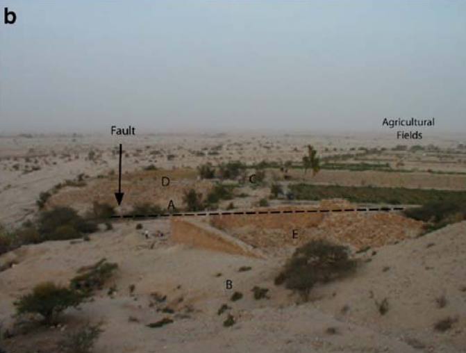 Fig. 2b
Birdseye view of the study area to west.
- Area A is located on west side of the birkeh
- Area B (influent aqueduct) is in the foreground
- Area C is the west trending aqueduct
- Area D is the Roman period for
- Area E is the interior of the aqueduct
Ancient and modern agricultural fields are in the background.
Haynes et. al. (2006)
- Fig. 2a - Site Map from
Haynes et. al. (2006)
 Fig. 2a
Site map of Qasr Tilah water structure (birkeh) and aqueduct with archaeological trenches of area A. WAF is the line trending N8°E. Trench A.7 encompasses offset aqueduct.
Haynes et. al. (2006) - Fig. 3 - Plan of ruptured
birkeh wall from Haynes et. al. (2006)
 Fig. 3
- NW-trending aqueduct and settling pool from Total Station survey data. Unexposed sections of the aqueduct are unexcavated trench boundaries (balks). The junction of the NW aqueduct with the west trending aqueduct is located at the lower left corner. The dashed line indicates approximate location of the west birkeh wall.
- Offset of aqueduct in Trench A.7 and vicinity.
- X: east aqueduct wall
- Y: aqueduct floor
- Z: west aqueduct wall
Offset measurements taken in the field and digitally from five locations along the aqueduct walls and floor along the trend of the fault (N8°E).
Haynes et. al. (2006)
- Fig. 2a - Site Map from
Haynes et. al. (2006)
Fig. 2a
Site map of Qasr Tilah water structure (birkeh) and aqueduct with archaeological trenches of area A. WAF is the line trending N8°E. Trench A.7 encompasses offset aqueduct.
Haynes et. al. (2006) - Fig. 3 - Plan of ruptured
birkeh wall from Haynes et. al. (2006)
Fig. 3
- NW-trending aqueduct and settling pool from Total Station survey data. Unexposed sections of the aqueduct are unexcavated trench boundaries (balks). The junction of the NW aqueduct with the west trending aqueduct is located at the lower left corner. The dashed line indicates approximate location of the west birkeh wall.
- Offset of aqueduct in Trench A.7 and vicinity.
- X: east aqueduct wall
- Y: aqueduct floor
- Z: west aqueduct wall
Offset measurements taken in the field and digitally from five locations along the aqueduct walls and floor along the trend of the fault (N8°E).
Haynes et. al. (2006)
- Photo of ruptured birkeh wall
(long shot) with fault motion annotated (by Jefferson Williams)
Photo of ruptured birkeh wall
Fault and fault motion annotated in pink
Photo by Jefferson Williams - Photo of ruptured birkeh wall
(medium shot) with fault motion annotated (by Jefferson Williams)
 Photo of ruptured birkeh wall
Fault and fault motion annotated in pink
Photo by Jefferson Williams - Photo of ruptured birkeh wall
(medium shot) by Jefferson Williams
 Photo of ruptured birkeh wall
Photo by Jefferson Williams - Fig. 2b - Photo of study area
from Haynes et. al. (2006)
Fig. 2b
Birdseye view of the study area to west.
- Area A is located on west side of the birkeh
- Area B (influent aqueduct) is in the foreground
- Area C is the west trending aqueduct
- Area D is the Roman period for
- Area E is the interior of the aqueduct
Ancient and modern agricultural fields are in the background.
Haynes et. al. (2006) - Photo of ruptured birkeh wall
(closeup) by Jefferson Williams
 Photo of ruptured birkeh wall
Photo by Jefferson Williams - Fig. 2c - Photo of ruptured
birkeh wall from Haynes et. al. (2006)
 Fig. 2c
Rupture of the west birkeh wall and aqueduct. Aqueduct channel is 0.74 m wide for scale.
Haynes et. al. (2006) - Offset stream near Qasr Tilah
with fault motion annotated (by Jefferson Williams)
 Offset stream near Qasr Tilah
- old stream course in black
- new stream course in green
- fault in pink
Photo by Jefferson Williams
- Fig. 7 - Sketch of the Roman-Nabatean
reservoir of Qasir el Telah from Galli and Galadini (2001)
 Fig. 7
Sketch of the Roman-Nabatean reservoir of Qasir el Telah with the trace of the AJF
(drawn by E. Cirese)
Galli and Galadini (2001)
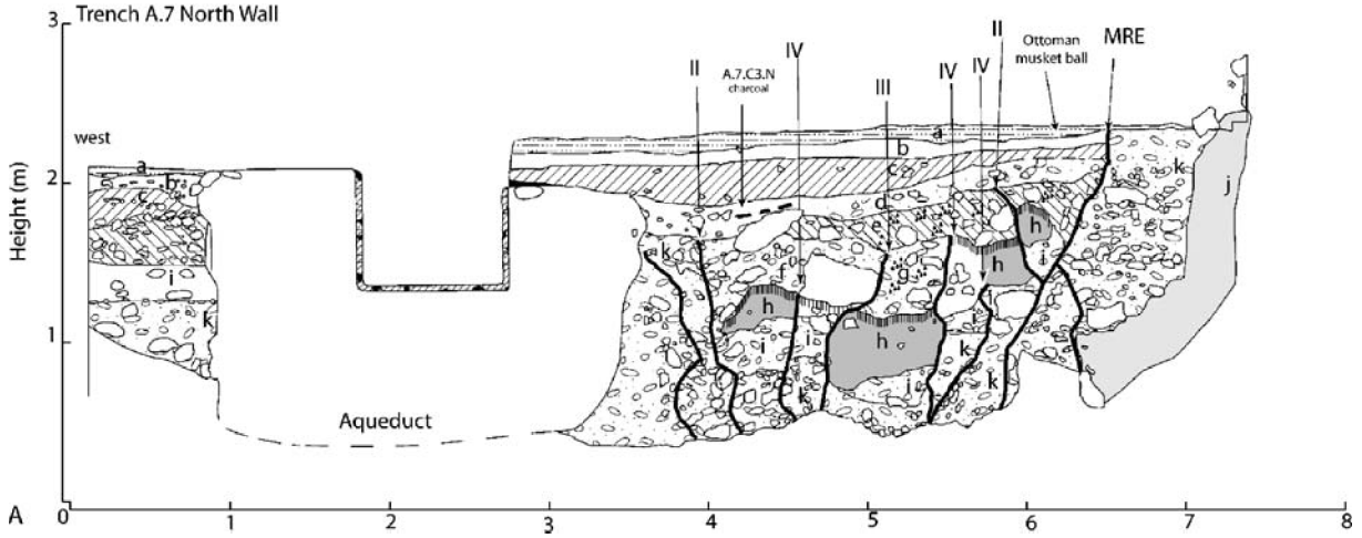 Figure 5
chematic diagram of Trench A.7 north wall. Stratigraphic units are identified by lowercase letters. Faults are emphasized by heavy lines. Earthquakes are identified by Roman numerals, with IV as the oldest. Dashed lines indicate unexcavated portion of aqueduct floor.
Haynes et al. (2006)
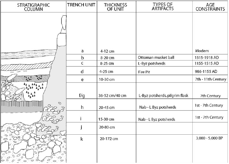 Figure 4
Schematic stratigraphic column of Trench A.7. Thicknesses of units are generalized from measurements of unit throughout the trench. Listed artifacts provide age control for constraining deposition and earthquake history in units where they were discovered. Age constraints come from radiocarbon data and typological dating of sherds.
Haynes et al. (2006)
-
Trench Log (Fig. 5) from
Haynes et al. (2006)
Figure 5
Schematic diagram of Trench A.7 north wall. Stratigraphic units are identified by lowercase letters. Faults are emphasized by heavy lines. Earthquakes are identified by Roman numerals, with IV as the oldest. Dashed lines indicate unexcavated portion of aqueduct floor.
Haynes et al. (2006) -
Stratigraphic Section (Fig. 4) from
Haynes et al. (2006)
Figure 4
Schematic stratigraphic column of Trench A.7. Thicknesses of units are generalized from measurements of unit throughout the trench. Listed artifacts provide age control for constraining deposition and earthquake history in units where they were discovered. Age constraints come from radiocarbon data and typological dating of sherds.
Haynes et al. (2006)