Jordan Valley Quake(s)
659/660 CE
by Jefferson Williams
Introduction & Summary
Textual Evidence
| Text (with hotlink) | Original Language | Religion | Date of Composition | Location Composed | Notes |
|---|---|---|---|---|---|
| Textual Evidence Summary | |||||
| Maronite Chronicle | Syriac | Maronite | shortly after 664 CE |
The Maronite Chronicle lists three earthquakes
|
|
| Chronicle of Theophanes | Greek | Orthodox (Byzantium) | 810-814 CE | Vicinity of Constantinople | Theophanes wrote that there was a great earthquake and collapse in Palestine and Syria in the month of Daisos (May/June)and probably in the year 659 CE |
| Chronology by Elias of Nisibis | Syriac and Arabic | Nestorian | 1st half of the 11th century CE | Nisibis (Nesaybin, Turkey) ? | Elias of Nisibis wrote that there was an earthquake and a great part of Palestine and many other places were ruined. He dated the earthquake to June 659 CE and cited his source as Jesudenah from the city of Basra. |
| Concise Description of the Holy Places by John Phokas | Greek | ~1185 CE | Described seismic damage (after the fact) to two monasteries in Palestine due to earlier earthquakes. His text was based on his travels to the area. | ||
| Early Islamic History, the Maronite Chronicle, and Theophanes | |||||
| Text (with hotlink) | Original Language | Religion | Date of Composition | Location Composed | Notes |
Archaeoseismic Evidence
| Location (with hotlink) | Status | Intensity | Notes |
|---|---|---|---|
| Qasr Tilah | possible | Haynes et al. (2006) examined paleoseismic and archeoseismic evidence related to damage to a late Byzantine—Early Umayyad birkeh (water reservoir) and aqueduct at Qasr Tilah and concluded that left lateral slip generated by several earthquakes cut through a corner of the reservoir and aqueduct creating displacement of the structures. The first seismic event was dated to the 7th century. Haynes at al (2006) suggested it was caused by either the Sword in the Sky Quake (633/634 CE) or the Jordan Valley Quake of 659/660 AD - favoring the Jordan Valley Quake. There was a repair after this 7th century destruction indicating that the site was occupied when the earthquake struck. Because of the repair, it it is unclear how much lateral slip was produced (or even if there was lateral slip during this earthquake ?). Haynes et al (2006) noted that archeological evidence at the site indicates that it was abandoned and was not occupied past the Early Umayyad Period (661-700 CE). If the repair fixed a problem caused by lateral slip rather than generalized destructive shaking, the slip would indicate that part of the Araba fault broke during this event. | |
| Petra - Introduction | n/a | n/a | n/a |
| Petra - Petra Theater | possible | Jones (2021:3 Table 1) reports a second
potential seismic destruction of the Theater in Phase VII noting that the Phase VII destruction of the Main Theatre is difficult to date, as the structure had gone out of use long before.Jones (2021:3 Table 1) suggested the late 6th century earthquake ( Inscription at Areopolis Quake) or the mid-8th century earthquake (e.g. earthquakes observed in the Qatar Trench in the South Araba by Klinger et al, 2015) as candidates. |
|
| Petra - Jabal Harun | possible | ≥ 6 | Phase 6 destruction was dated to the 1st half of the 7th century CE by Mikkola et al (2008). Destruction was inferred based on rebuilding evidence in Phase 7. No unambiguous and clearly dated evidence of seismic damage was found. Mikkola et al (2008) also noted a change in liturgy in Phase 7 which could have also been at least partly responsible for the rebuild. |
| Petra - The Petra Church | possible | ≥ 8 | Fiema et al (2001) characterized structural destruction of the church in Phase X as likely caused by an
earthquake with a date that is not easy to determine. A very general terminus post quemof the early 7th century CE was provided. Destruction due to a second earthquake was identified in Phase XIIA which was dated from late Umayyad to early Ottoman. Taken together this suggests that the first earthquake struck in the 7th or 8th century CE and the second struck between the 8th and 16th or 17th century CE. |
| Yavne | probable | ≥ 7 |
Langgut et al (2015) examined the kiln complex of a pottery factory near Tel Yavne
which was destroyed sometime in the 7th century. They examined seasonal pollen beneath crushed pots inside the kilnwhich suggested collapse around June (Jordan Valley Quake of 659/660 AD) instead of September (Sword in the Sky Quake of 633/634 CE). A site effect may be present. Epicenter was possibly to the ESE |
| Bet Sh 'ean | possible | Tsafrir and Foerster (1997:143-144) dated a seismic destruction event to the 7th century CE.
The event caused the destruction of Silvanus Hall; all the columns in the southwest part of the hall were found collapsed in the same direction, in a way that leaves no doubt about the cause of the destruction.They suggested it was likely that the same earthquake caused the collapse of the porticoes of the Byzantine agora, the portico of the sigma, and most probably the columns of Palladius Street. |
|
| Hammat Gader | possible | Phase IIB Earthquake (?) - Hirschfeld et al. (1997:6)
note that, while it is not clear what fate befell the baths [in Phase II] at the end of the Byzantine period, it seems that the place was struck by one of the earthquakes that occurred in the region. The resulting damage, they state, is attested in the “Mu’awiya inscription” (no. 54) discovered at the site. This inscription, dated accurately to the year 662 C.E., details renovation activity carried out by Mu’awiya, the first Umayyad Caliph, but does not specifically mention an earthquake or prior damage to the site. This site may be subject to a liquefaction site effect as it is located on an oxbow of the Yarmuk River in a location that sits atop a thermal spring. At the same time, one must consider that the building’s state of preservation and the fact that the walls stand vertically without cracksled Hirschfeld et al. (1997:16) to conclude that the builders of the foundations did an excellent job, taking advantage of the best knowledge, skills, and certainly the well-known Roman cement. |
|
| Jerash - Introduction | n/a | n/a | n/a |
| Jerash - Umayyad House | possible | Gawlikowski (1992:358)
reports that the Umayyad house was built on level ground after an earthquake.Construction was well dated by the numismatic findings. Earthquake destruction is inferred based on rebuilding evidence. |
|
| Jerash - Macellum | probable | ≥ 8 |
Uscatescu and Marot (2000:283) dated seismic destruction of the Macellum to at the latest to the second quarter of the seventh centurybased on pottery and coins. The seismic destruction layer was found in a sealed and undisturbed context and is well-dated. Uscatescu and Marot (2000:281) report extensive destruction [] well evidenced by the fallen vaulted and tiled roofs and collapsed walls; a huge collapse that reaches a thickness of more than two and a half metres,and was composed by voussoirs, tiles, ashlars, architraves, column shafts, capitals and other architectonic elements. |
| Jerash - Temple of Zeus | possible | ≥ 8 | Rasson and Seigne (1989) reported on excavations of a cistern at the Temple of Zeus.
Two seismic destruction events were interpreted from the excavation - one in the 7th century CE and another in the 8th.
The 1st seismic event was manifest in partial roof collapse. Ceramics beneath the collapse layer dated to the Umayyad period and suggested an earthquake
Which struck in the middle of the 7th century CE. Gawlikowski (1992:358) reports
further 7th century CE archaeoseismic evidence in a vaulted corridor of the lower terrace where a herd of goats was buried along with a kid goat.
According to Gawlikowski (1992:358), the age of a kid indicates that the cataclysm took place in May-June and moreover a Byzantine currency with an Arab countermark indicating the beginning of Muslim government (Seigne, unpublished report of 1984, kindly communicated by the author).This would suggest that the 1st earthquake was the one of the Jordan Valley Quake(s). |
| Jerash - Hippodrome | possible | ≥ 8 | Ostrasz and Kehrberg-Ostrasz (2020:4) report that
the masonry of most of the building collapsedwith only the carceres and the south-east part of the caveasurviving. Archaeological evidence seems to constrain the date of this earthquake to the 6th to 7th centuries CE. |
| Heshbon | possible | ≥ 8 | Walker and LaBianca (2003:453-454) uncovered
7th century CE archeoseismic evidence which they attributed to the Jordan Valley Quake of 659/660 CE from an excavation of an Umayyad-period
building in Field N of Tall Hesban. They report a badly broken hard packed yellowish clay floor which was
pocketed in places by wall collapse and accompanied by crushed storage jars, basins, and
cookware. Storage jars and basins and cookware were dated in the field to the transitional Byzantine-Umayyad period. |
| Hippos Sussita | probable | ≥ 8 | 7th or Early 8th century CE Earthquake - Segal et al. (2013:210)
suggest that the Northwest Church suffered damage in a 7th or early 8th century CE earthquake.
The final phase of the church (Phase III) was the decline of the basilica which must have been the result of some unspecified disaster of an unknown date but which clearly caused serious damage to the nave; it was probably one of the earthquakes which affected this region in the second half of the 7th century (658 CE) or at the beginning of the 8th century (717 CE).101 Indeed, eloquent testimony to the ancient repairs made to the mosaic floor can be seen at the southern pastophorion. Right under the arched entrance to this room, the mosaic bears traces of repairs carried out after it was damaged, probably during an earthquake (fig. 281).Although Segal et al. (2013:210) suggested the the 717 CE Earthquake as a possible candidate, the epicenter of this event was likely too far away to have caused such damage. The Jordan Valley Quake(s) of 659/660 CE, however, is a plausible candidate as is an earthquake unreported in currently extant historical records. The potential for a topographic or ridge effect appears to be present at this location. |
| Tell es-Samak/Tel Shiqmona | possible to unlikely | ≥ 7 | 7th century CE Earthquake (?) - Barzilay (2012) interpreted flexed stone structures as a consequence of a 7th century CE earthquake and estimated a local site Intensity of VII or higher. Excavator Hagit Torge (personal communication, 2021) attributed the deformations to the active clay soil. Taxel (2013:79-80) also cast doubt on the possibility that the site was damaged by an earthquake leading to it's abandonment. The Deformation Map shows that the displaced walls are due to vertical uplift and suggest an expansive active soil as the cause. If an earthquake caused the chaotic deformation patterns shown in the map, the site would have to have been above the hypocenter of a powerful earthquake which seems unlikely. If this was the case, more extensive deformation and collapse would be expected form this site and nearby sites and the local Intensity would have been IX (9) or higher. Thus, I agree with Hagit Torge (personal communication, 2021) and Taxel (2013:79-80) that a seismic origin for the observed deformations is not likely. |
| Khirbet al-Niʿana | possible | 7th century CE earthquake -
Taxel (2013:178-179) noted the following about archaeoseismic evidence in Khirbet al-Niʿana
Excavation of the western fringes of the inhabited area (the results of which were only preliminarily published) show no clear evidence for occupation ater the mid-seventh century. According to the excavator (Torge, 2010)The site was largely abandoned at the beginning of the Umayyad period and most of the masonry stones were plundered. The signs of destruction and burning may point to its destruction in the earthquake of 633 CE.Unfortunately, however, the basis for this dating was not provided in the report. |
|
| Pella | possible | ≥ 8 |
Blanke and Walmsley (2022:86) report that Urban Fiḥl was badly impactedby a 7th century CE earthquake resulting in permanent reconfigurations to the town’s layout. Dating was established by secure ceramic comparisons with the corpus from excavations of the eastern residential area on the main mound [i.e. Pella].Although some of the reported archaeoseismic evidence may be based on rebuilding evidence, there are direct observations of interpreted seismic damage. Smith (1973:165) attributed damage to the West Church Complex (Area I) to the 659/660 CE Jordan Valley Quake(s) while noting that this event toppled most of the upper part of the walls of the sanctuary and Atrium and damaged the north dependency. Smith et al. (1989:92) suggested that this earthquake also damaged the Area IX Church. |
| Monastery of Euthymius | probable | 9 |
Hirschfeld (1993:354) inferred
that the monastery was destroyed by a 7th century earthquake based on rebuilding evidence. Reconstruction was dated to the 2nd half of the 7th century
apparently based on the early Muslim period style of construction. The Maronite Chronicle states that the Monastery of Euthymius was destroyed by
an earthquake in A.G. 971 (660-661 CE) along with the dwellings of many monks and solitaries. This suggests that the near total rebuild observed by Hirschfeld (1993) was due to near total collapse which leads to an intensity estimate of IX (9). |
| Monastery of John the Baptist | possible | The Maronite Chronicle states that the Monastery of John The Baptist (Mār John aka Qasr al-Yehud) was destroyed -
uprooted from its foundations- in A.G. 971 (660-661 CE). I'm not aware of an corroborating archaeoseismic evidence. |
|
| Monastery of Khirbet es-Suyyagh | possible | ≥ 8 | 7th century CE Earthquake(s) - Taxel et al (2009) surmised
that Phase IIA ended with an earthquake and established a terminus post quem of 629/630 CE for repairs to damaged parts of the monastery at the start of Phase IIB.
This was based on a 629/630 CE coin found below the mosaic floor in the northern aisle of the church (Locus 387) attributed to Phase IIB. Another coin of Constans II (641-648 CE) was found in the fill that covered the corridor north of the main gate (Locus 281)however it was noted that this fill could also be related to the construction of the blocking wall of the corridor in Phase III. Pottery found below the fieldstone paving which abutted on the new (southern) storeroom in the external courtyard and to the repaired doorway of the subsidiary gate (Loci 181 and 183)was dated to the mid-late 7th century. Lack of fire evidence and evidence of archaeoseismic damage led Taxel et al (2009) to conclude that observed damage and repairs of damage was probably due to an earthquake(s) although destruction due to Persian and, later on, Muslim military activity could not be entirely ruled out. Schmuel Marco in Taxel et al (2009:186-187) suggested that seismic intensity may have reached IX (1 g) apparently largely based on the broken threshold of the Main Gate and rebuilding evidence which inferred wall collapses down to the foundations. Archaeoseismic evidence at the Monastery of Euthymius as reported by Hirschfeld (1993) showed evidence for a near total rebuild after it was presumably destroyed in one of the Jordan Valley Quake(s) of 659/660 CE. Although direct archaeoseismic evidence was not observed at the Monastery of Euthymius, the contemporary Maronite Chronicle reported that the Monastery of Euthymius collapsed during this earthquake - which supports the idea that a near total rebuild supports such a high level of local seismic intensity. However, the Monastery of Euthymius is closer to active Jordan Valley faults that seem to have broken during the Jordan Valley Quake(s) which means that Khirbet es-Suyyagh, further away from these faults, would have likely experienced lower levels of intensity during this event(s). This would explain why there were repairs at Khirbet es-Suyyagh rather than a complete rebuild. Given the distance between Khirbet es-Suyyagh and the active faults of Jordan Valley and the Dead Sea, Schmuel Marco in Taxel et al (2009:186-187) suggested that such an elevated intensity estimate (guesstimate ?) of IX (1 g) could be explained by a site effect or being above the hypocenter when the Quake struck (e..g in a blind thrust scenario). While a site effect is possible as it is described as being located on a spur, the Deformation Map (see in Figures above) suggests that North-South walls were preferentially damaged which is not what one would suspect above a hypocenter where inclination and collapse typically do not display directional patterns. Such directional patterns, which seem to be evident at Khirbet es-Suyyagh, are what one would expect at some distance form the epicenter (e.g. see Korzhenkov and Mazor, 1999). |
| Caesarea | possible | ≥ 8 | mid-7th century CE Earthquake - According to Raban et al. (1993 v. I:64), Vault 2 in Area CV collapsed
suddenly, crushing pottery vessels that had been resting on the floors. The destruction was dated to the mid-7th century CE, with
researchers attributing the collapse to seismic activity. This dating was based on ceramics and coins, the most recent of which
belonged to the reign of Heraclius [r. 610-641 CE]. Two possible earthquake events were suggested as causes: the ~634 CE Sword in the Sky Quake and the 659/660 CE Jordan Valley Quake(s). Raban et al. (1993 v. I:64) reported that Vault 2 was a two-story structure that collapsed downward, with its arcade falling downward and westward. Additionally, evidence suggested that the second-story floor had flipped over during the event. |
| Mount Nebo | needs investigation | ||
| Ein Hanasiv | possible | ≥ 8 | Karcz et. al. (1977) list archeoseismic evidence (oriented collapse, alignment of fallen masonry) in Ein Hanasiv in the 7th century AD based on Vitto (1975). |
| Giv’ati Junction | possible | ≥ 7 | Baumgarten (2001) excavated a round pottery kiln at Giv'ati Junction dated to the
4th-7th century CE (Shmueli, 2013).
Langgut et al (2015) report that four fired Late Roman Amphora (similar to those at Yavne) "were found inside the
kiln’s collapsed firing chamber" covered by a thick layer of aeolian sand. Langgut et al (2015) noted that while "the excavator
suggested that the kiln was destroyed during operation, possibly due to some technical fault, and was consequently abandoned (Baumgarten 2001)",
Langgut et al (2015) believe an earthquake should also be considered as a cause of destruction. Shmueli (2013) excavated Stratum III in a rectangular building (L109, L119) at Giv'ti Junction in 2011 where, on the floor, they found three Gaza jars which were set upside down (Fig. 4) and broken. A fourth jar was found upright but also broken. Based on numismatic finds, they dated the beginning of the settlement to the fourth or fifth century CE. Construction and use of the rectangular building was dated to the fifth to seventh centuries CE. In the seventh century the installation and building went out of use. |
| Avdat/Oboda | possible | ≥ 8 | 7th century Earthquake - A terminus post quem for a 7th century CE earthquake was established from the latest inscription found at the site in the Martyrion of St. Theodore (South Church) in 617 CE (Negev 1981: 37)(Erickson-Gini, 2014). Erickson-Gini (2014) noted that there was massive destruction evident throughout the site, and particularly along the western face of the site with its extensive caves and buildings (Korjenkov et al., 1996).Korzhenkov and Mazor (1999) uncovered extensive archeoseismic effects from the earthquake and estimated an Intensity of 9 - 10, posited that destruction was caused by a compressional seismic wave, and located the epicenter SSW of Avdat somewhere in central Negev. Discontinuous Deformation Analysis of the bulges in the Roman Tower of Avdat by Kamai and Hatzor (2005) leads to an Intensity Estimate of 8 - 10. A Ridge Effect is likely present at Avdat |
| Mizpe Shivta | possible | Erickson-Gini (personal correspondence, 2021) relates that this site in the Negev suffered seismic damage in the 7th century CE - sometime after 620 CE. | |
| Mezad Yeruham | possible | Erickson-Gini (personal correspondence, 2021) relates that this site in the Negev suffered seismic damage in the 7th century CE - sometime after 620 CE. | |
| Shivta | possible | ≥ 8 | Late Byzantine Earthquake - Early 7th century CE ? -
Erickson-Gini (2013) suggested that a revetment wall outside Room 123 was evidence of a Late
Byzantine earthquake
Revetment walls present around the North Church and buttressing the western wall of Building 123 (Hirschfeld 2003 - see highlighted site plan above) are indications that some damage to the site took place in the Late Byzantine period, probably in the early seventh century CE when the neighboring site of ‘Avdat/Oboda was destroyed in a tremendous earthquake.A site effect at Shivta is unlikely due to a hard carbonate bedrock. Korzhenkov and Mazor (1999a) estimate Intensity of 8 -9 with the epicenter a few tens of km. away and to the WSW |
| Rehovot ba Negev | possible | ≥ 8 | "The Byzantine Shock" - 7th century CE - Korzhenkov and Mazor (2014) identified an earthquake which they beleive struck in the 7th century CE. Rehovot ba Negev appears to be built on weak ground. There is a probable site effect present as much but not all of Rehovot Ba Negev was built on weak ground (confirmed by A. Korzhenkov, personal communication, 2021). Korzhenkov and Mazor (2014) estimated an Intensity of 8-9 with an epicenter to ESE. |
| Saadon | possible | ≥ 7 | Phase 2 Earthquake - mid-7th century CE -
Erickson-Gini (2018) reports that The [Southwestern] church was heavily damaged and subsequently repaired in the mid-7th century CE and continued to be used for several years in the Umayyad period (mid-7th - 8th centuries CE). A `wine-press' hewn along the bedrock shelf on the northeast bank of Nahal Sa'adon was apparently broken by the same seismic event.Damage observations reveal that walls aligned in a WNW direction were damaged. |
| Nessana | possible | Erickson-Gini (personal correspondence, 2021) relates that Nessana suffered seismic damage in the 7th century CE - sometime after 620 CE. | |
| Mamphis | possible | ≥ 8 | The 2nd earthquake at Mampsis suffers from dating ambiguities and a chronological debate between Negev (1974:412, 1988) and Magness (2003). Considering all possibilities of this debate leads to a date between the 5th and 7th centuries CE. Korzhenkov and Mazor (2003) estimated an Intensity of 9 or more with an epicenter to the SW. |
| Haluza | possible | ≥ 8 | Second earthquake.
Korjenkov and and Mazor (2005) discussed chronology of the second earthquake.
The Early Arab – Second Ancient EarthquakeKorjenkov and and Mazor (2005) noted that while the Sword in the Sky Quake of 634 CE destroyed Avdat 44and ruined other ancient towns of the Negev 45, archeological data demonstrate that occupation of the [Haluza] continued until at least the first half of the 8th cent. A.D.46. This led them to conclude that one of the mid 8th century CE earthquakes was a more likely candidate. Unfortunately, it appears that we don't have a reliable terminus ante quem for the second earthquake. Korzhenkov and Mazor (1999a) estimated a minimum Intensity of 8-9 with an epicenter a few tens of kilometers away and an epicentral direction to the NE or SW - most likely to the NE |
| Aqaba/Eilat - Introduction | n/a | n/a | n/a |
| Aqaba/Eilat - Aila | possible | 7 |
Thomas et al (2007) identified earthquake destruction (Earthquake IV) in a collapse layer which they suggested struck in the early to middle 7th century CE.
The pottery constrains the date of Earthquake IV to sometime between the seventh century and the mid seventh to eighth century. In this case, an early to middle seventh-century date would best fit the dating evidence. |
| Aqaba/Eilat - Ayla | posible but unlikely | ≥ 8 |
The first earthquake was revealed in the constructions built during the late Rashidun period (644-656 A.D.)( al-Tarazi and Khorjenkov, 2007) thus providing a terminus post quem of 644-656 A.D.. A terminus ante quem of ~750 CE was provided by the Early Abbasid structures built after the first seismic destruction. This suggests that the seismic damage was caused by the Jordan Valley Quake of 659/660 CE (less likely due to distance) or one of the mid 8th century CE earthquakes. In reporting on excavations in 2008, Damgaard (2008) observed substantial infilling and leveling in Phase 3 which based on its artefactual yield, must be considered Abbasid in dateand corresponds roughly to Whitcomb's `Phase B'. Damgaard (2008) suggested that this levelling appears to be associated with a period of widespread reconstruction following a significant collapse - most probably due to the 748 CE earthquake. Of particular interest was an east-west running wall perpendicular to a north-south running wall (L57/W13). Only the negative profile of this wall remains - i.e. it is a robber trench. Although nothing of its foundation remains, the fact that the remnants of a wall [are] now gone was confirmed by a patterned collapse of mud-brick (including a carbonised wooden beam) on its south side. Damgaard (2011, Appendices:12) also reports a collapse layer in Tower 2 dated to the mid 8th century. Thus, it appears that the terminus ante quem is fairly reliable for this archeoseismic evidence and suggests a mid 8th century CE earthquake. A site Effect likely present as the location appears susceptible to liquefaction. It is next to the beach and there is a shallow water table. al-Tarazi and Khorjenkov (2007) estimated an intensity of IX or more and surmised that the epicenter was close - a few tens of kilometers away. They estimated that the epicenter was to the NE. |
| el-Lejjun | possible | ≥ 8 | The 3rd earthquake is dated to between ~530 and ~750 CE. Numismatic finds and demobilization evidence provide a terminus post quem of ~530 CE. Groot et al (2006:183) report discovery of a nearly complete Umayyad Lamp in Square 4 of Area B (Barracks - B.6.038) in the Post Stratum Gap (551 - 1900 CE) - above and later than the 3rd earthquake layer which provides a terminus ante quem of ~750 CE. It is likely that the 3rd earthquake was the Inscription at Areopolis Quake as Areopolis is only ~12 km. away from el-Lejjun. The 4th Earthquake is dated to between ~600 CE and 1918 CE. It lacks a reliable terminus ante quem. |
| Apamea | unlikley to possible | Walmsley (2007b:334), without citing a reference, claims archaeoseismic evidence at Apamea due to the Jordan Valley Quake of 659/660 CE. Unless an earthquake couplet was involved, such an assignment seems unlikely due to distance. The causitive earthquake may have been an earthquake at Aleppo which is discussed in the Notes section for the Sword in the Sky Quake of ~634 CE (collapsible panel titled Earthquake in Aleppo) and in Archaeoseismic Evidence for Aleppo in the Sabbatical Year Earthquakes entry. | |
| Location (with hotlink) | Status | Intensity | Notes |
Tsunamogenic Evidence
Paleoseismic Evidence
| Location (with hotlink) | Status | Intensity | Notes |
|---|---|---|---|
| al-Harif Syria | possible | ≥ 7 | Sbeinati et al (2010)
state that Event Y, characterized from paleoseismology, appears to be older than A.D. 650–810 (unit d, trench A) and younger than A.D. 540–650 (unit d3 in trench C). The results of archaeoseismic investigations indicate that ages of CS-1 (A.D. 650–780) and tufa accumulation CS-3-3 (A.D. 639–883) postdate event Y.Combined together, this constrains Event Y to 540-780 CE. |
| Bet Zayda | possible | ≥ 7 | Wechsler at al. (2014) may have seen evidence for this earthquake as Event CH3-E1 (Modeled Age 662-757 CE). Event CH2-E1, which struck next (Modeled Age 675-801 CE), appears to correlate with the Holy Desert Quake of the Sabbatical Year Earthquake sequence. |
| Dead Sea - Seismite Types | n/a | n/a | n/a |
| Dead Sea - ICDP Core 5017-1 | possible | 7 | Lu et al (2020) associated a turbidite in the core to a middle 8th century earthquake. CalBP is reported as 1248 ± 44 yr B.P. This works out to a date of 702 CE with a 1σ bound of 658 - 746 CE indicating that the Jordan Valley Quake, Sword in the Sky Quake, and the Sabbatical Year Quakes are all possibilities. Ages come from Kitagawa et al (2017). The deposit is described as a 16.5 cm. thick turbidite (MMD). Lu et al (2020) estimated local seismic intensity of VII which they converted to Peak Horizontal Ground Acceleration (PGA) of 0.18 g. Dr. Yin Lu (personal correspondence, 2021) relates that "this estimate was based on previous studies of turbidites around the world (thickness vs. MMI)" ( Moernaut et al (2014). The turbidite was identified in the depocenter composite core 5017-1 (Holes A-H). |
| Dead Sea - En Feshka | probable | 5.6-6.4 | Kagan et. al. (2011) assigned a 660 AD date [707 AD ± 41 (±1σ) - 686 AD ± 87 (±2σ)] to a 3 cm . thick Type B (microbreccia) seismite at a depth of 157.0 cm.. |
| Dead Sea - En Gedi | possible | 5.6-6.3 | Migowski et. al. (2004) assigned a date of 660 AD to a 0.5 thick Type 1 (linear waves) seismite at a depth of 1.99 m. |
| Dead Sea - Nahal Ze 'elim | no evidence | At site ZA-2, Kagan et. al. (2011) did not assign any seismites to a date of 660 AD. No seismites in her section have a modeled age which overlaps with a 659/660 CE date (± 1σ or ± 2σ). | |
| Araba - Introduction | n/a | n/a | n/a |
| Araba - Taybeh Trench | possible | ≥ 7 | LeFevre et al. (2018) might have seen evidence for this earthquake in the Taybeh Trench (Event E3 - Modeled Age 551 AD ± 264). |
| Araba - Qatar Trench | no evidence | ≥ 7 | The Jordan Valley Quake is just outside the modeled ages for Events E4 (758 CE ± 87), E5 (758 CE ± 87), and E6 (251 CE ± 251) (Klinger et. al., 2015). |
| Location (with hotlink) | Status | Intensity | Notes |
Notes
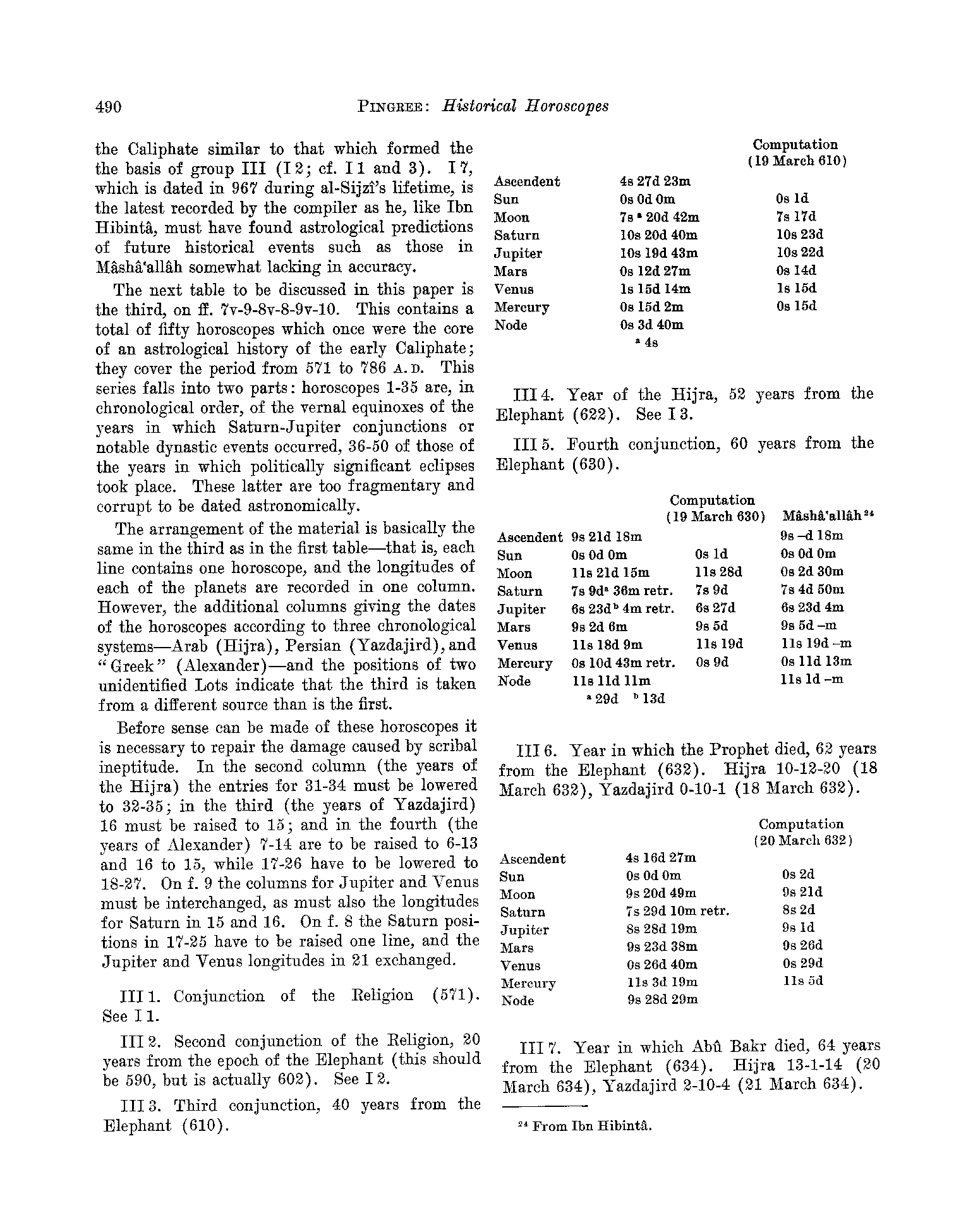
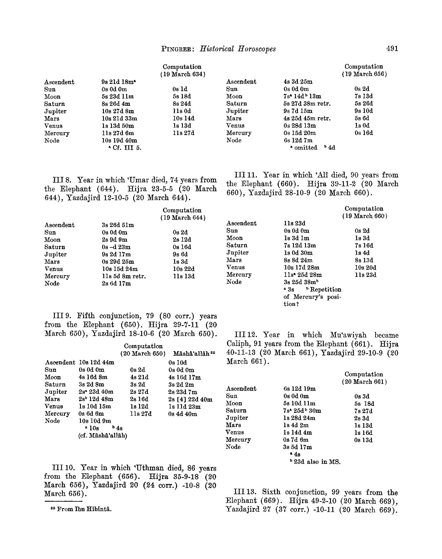
Theophilus of Edessa was a professional astrologer and his lost history may have sourced some of the extant textual accounts. This is here in case it provides some insight
into any celestial observations accompanying this or other relevant earthquakes. The tables below come from:
Pingree, D. (1962). "Historical Horoscopes." Journal of the American Oriental Society 82(4): 487-502.
JW: Everybody dies on 20 March ?