Khirbet es-Suyyagh
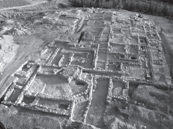 Figure 2.12
General view of the site, looking north
Taxel et al (2009)
| Transliterated Name | Language | Name |
|---|---|---|
| Khirbet es-Suyyagh | Arabic |
- Fig. 1.1 - Location map
from Taxel et al (2009)
 Fig. 1.1
Location map of Khirbet es-Suyyagh.
Taxel et al (2009)
- Fig. 2.12 - Aerial view of the
site from Taxel et al (2009)
Fig. 2.15
Figure 2.12
General view of the site, looking north
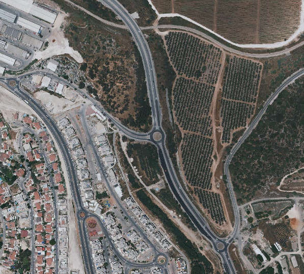
Taxel et al (2009) - Approximate location of Khirbet es-Suyyagh
in Google Earth
 Approximate location of Khirbet es-Suyyagh in Google Earth
click on image to explore this site on a new tab in Google Earth - Approximate location of Khirbet es-Suyyagh
on govmap.gov.il
 Approximate location of Khirbet es-Suyyagh on govmap.gov.il
click on image to explore this site on a new tab in govmap.gov.il
- Fig. 1.1 - General plan of
Khirbet es-Suyyagh from Taxel et al (2009)
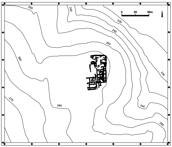 Fig. 1.1
General plan of the site.
Taxel et al (2009) - Fig. 2.13 - General reconstruction
of the monastery from Taxel et al (2009)
 Fig. 2.15
General reconstruction of the monastery, looking northwest
Drawing by Yura Smertenko
Taxel et al (2009) - Fig. 2.1 - Plan of Phase I
and Phase II from Taxel et al (2009)
 Fig. 2.1
Plan of Phase I and Phase II .
Taxel et al (2009) - Fig. 2.75 - Plan of Phase III
from Taxel et al (2009)
 Fig. 2.75
Plan of Phase III
Taxel et al (2009)
- Fig. 1.1 - General plan of
Khirbet es-Suyyagh from Taxel et al (2009)
Fig. 1.1
General plan of the site.
Taxel et al (2009) - Fig. 2.13 - General reconstruction
of the monastery from Taxel et al (2009)
Fig. 2.15
General reconstruction of the monastery, looking northwest
Drawing by Yura Smertenko
Taxel et al (2009) - Fig. 2.1 - Plan of Phase I
and Phase II from Taxel et al (2009)
Fig. 2.1
Plan of Phase I and Phase II .
Taxel et al (2009) - Fig. 2.75 - Plan of Phase III
from Taxel et al (2009)
Fig. 2.75
Plan of Phase III
Taxel et al (2009)
- Fig. 2.16 - Reconstruction of
the gateway from Taxel et al (2009)
 Fig. 2.16
Reconstruction of the gateway, looking north
Drawing by Yura Smertenko
Taxel et al (2009) - Fig. 2.15 - Plan of the
gatehouse complex and the southern area of the monastery from Taxel et al (2009)
 Fig. 2.15
Plan of the gatehouse complex and the southern area of the monastery.
Taxel et al (2009) - Fig. 2.76 - Plan of Phase III
gatehouse area and the southern area from Taxel et al (2009)
 Fig. 2.76
Plan of the gatehouse area and the southern area of the monastery during Phase III.
Taxel et al (2009)
- Fig. 2.16 - Reconstruction of
the gateway from Taxel et al (2009)
Fig. 2.16
Reconstruction of the gateway, looking north
Drawing by Yura Smertenko
Taxel et al (2009) - Fig. 2.15 - Plan of the
gatehouse complex and the southern area of the monastery from Taxel et al (2009)
Fig. 2.15
Plan of the gatehouse complex and the southern area of the monastery.
Taxel et al (2009) - Fig. 2.76 - Plan of Phase III
gatehouse area and the southern area from Taxel et al (2009)
Fig. 2.76
Plan of the gatehouse area and the southern area of the monastery during Phase III.
Taxel et al (2009)
- Fig. 2.57 - Plan of church complex
from Taxel et al (2009)
 Fig. 2.57
Plan of the church complex.
Taxel et al (2009)
- Fig. 2.57 - Plan of church complex
from Taxel et al (2009)
Fig. 2.57
Plan of the church complex.
Taxel et al (2009)
- Fig. 2.31 - Plan of the tower
from Taxel et al (2009)
 Fig. 2.31
Plan of the tower.
Taxel et al (2009)
- Fig. 2.58 - The Church with asymmetric
apse from Taxel et al (2009)
 Fig. 2.58
The church (30):
Above) looking north
Below) Section C-C (see Fig. 2.57) through church, looking west.
JW: Note asymmetric apse
Taxel et al (2009) - Fig. 2.62 - Southern (repaired) wall
of the apse from Taxel et al (2009)
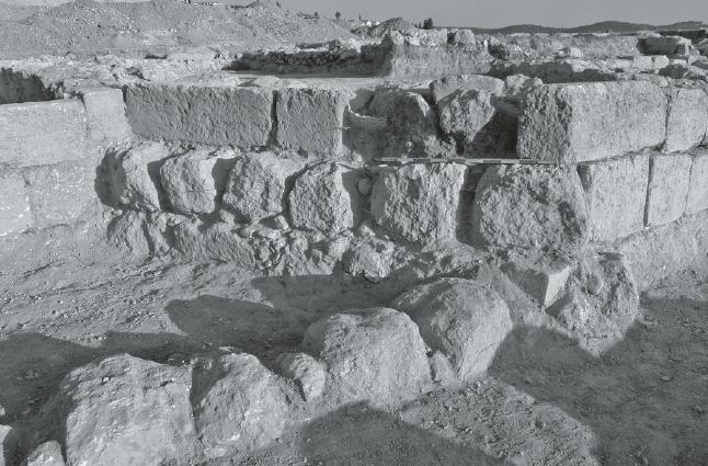 Fig. 2.62
the southern (repaired) wall of the apse (W223), looking northwest.
Taxel et al (2009) - Fig. 2.77 - Phase III blocking wall (W210)
from Taxel et al (2009)
 Fig. 2.77
the southeastern corner of Hall 31 and the Phase III blocking wall (W210) of the entrance corridor
Taxel et al (2009) - Fig. 2.78 - eastern end of W210
from Taxel et al (2009)
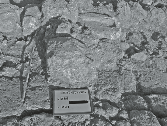 Fig. 2.78
the eastern end of W210, built over the threshold of Courtyard 2
Taxel et al (2009) - Fig. 2.85 - Phase III walls (W115, W116)
in Room 13 from Taxel et al (2009)
 Fig. 2.85
Phase III walls (W115, W116) in Room 13, looking north
Taxel et al (2009) - Fig. 2.32 - Fracture in the
Northern doorway of the tower from Taxel et al (2009)
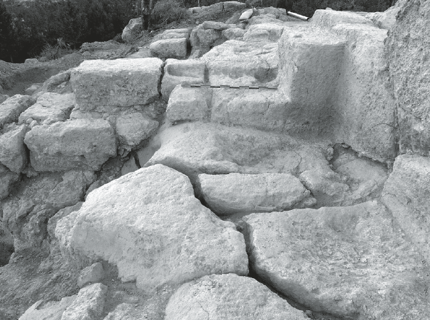 Fig. 2.32
the northern doorway of the tower, looking east.
JW: Fracture may be due to soil creep along slope to the left
Taxel et al (2009) - Fig. 2.84 - Crushed storage jar
between W131 and W147 from Taxel et al (2009)
 Fig. 2.84
Crushed storage jar and a lid between W131 and W147.
Taxel et al (2009) - Fig. 2.34 - Crushed Storage Jars
in the basement from Taxel et al (2009)
 Fig. 2.34
Crushed storage jars in the northeastern corner of the basement (L148).
Taxel et al (2009) - Fig. 2.27 - Crushed pottery on the floor of room 5
from Taxel et al (2009)
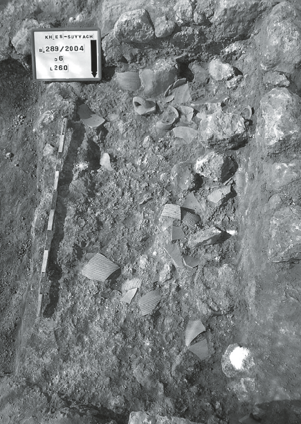 Fig. 2.27
Crushed pottery on the floor of room 5 (L260).
Taxel et al (2009) - Fig. 2.87 - Re-used marble fragment
in Phase III wall (W209) in Hall 31 from Taxel et al (2009)
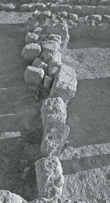 Fig. 2.87
Phase III wall (W209) in Hall 31, looking north. Note the reused marble column fragment at the middle of the wall
Taxel et al (2009) - Fig. 2.63 - Re-used Building element (lintel)
from Taxel et al (2009)
 Fig. 2.63
A lintel reused in the central wall of the apse (W223).
Taxel et al (2009) - Fig. 2.24 - Threshold of Courtyard 2
from Taxel et al (2009)
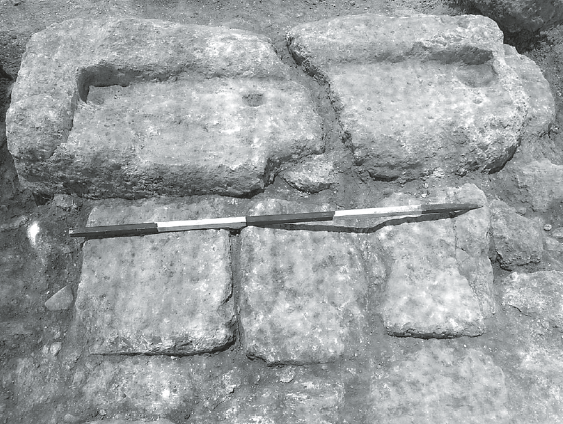 Fig. 2.24
the threshold of Courtyard 2, looking west.
Taxel et al (2009)
| Effects | Location | Image(s) | Description |
|---|---|---|---|
|
Subsidiary Gate and The Large Central Courtyard
Fig. 2.1 Plan of Phase I and Phase II . Taxel et al (2009)
Fig. 2.15General reconstruction of the monastery, looking northwest Drawing by Yura Smertenko Taxel et al (2009) |
|
|
|
Apse of the Church
Fig. 2.1 Plan of Phase I and Phase II . Taxel et al (2009)
Fig. 2.15General reconstruction of the monastery, looking northwest Drawing by Yura Smertenko Taxel et al (2009)
Fig. 2.57Plan of the church complex. Taxel et al (2009) |
Fig. 2.58 The church (30): Above) looking north Below) Section C-C (see Fig. 2.57) through church, looking west. JW: Note asymmetric apse Taxel et al (2009)
Fig. 2.62the southern (repaired) wall of the apse (W223), looking northwest. Taxel et al (2009) |
|
|
Main Gate
Fig. 2.1 Plan of Phase I and Phase II . Taxel et al (2009)
Fig. 2.15General reconstruction of the monastery, looking northwest Drawing by Yura Smertenko Taxel et al (2009)
Fig. 2.15Plan of the gatehouse complex and the southern area of the monastery. JW: Broken threshold is in Square D/5 to the lower left. Note elevation differences Taxel et al (2009) |
Fig. 2.24 the threshold of Courtyard 2, looking west. Taxel et al (2009) |
|
|
Gatehouse
Fig. 2.1 Plan of Phase I and Phase II . Taxel et al (2009)
Fig. 2.15General reconstruction of the monastery, looking northwest Drawing by Yura Smertenko Taxel et al (2009)
Fig. 2.15Plan of the gatehouse complex and the southern area of the monastery. Taxel et al (2009) |
|
|
|
Southern end of Wall W33
Fig. 2.1 Plan of Phase I and Phase II . Taxel et al (2009)
Fig. 2.15General reconstruction of the monastery, looking northwest Drawing by Yura Smertenko Taxel et al (2009)
Fig. 2.15Plan of the gatehouse complex and the southern area of the monastery. JW: Rebuilt part of wall W33 is on the far right in Squares E/5-6 Taxel et al (2009) |
|
|
|
Wall W100 in Room 19
Fig. 2.1 Plan of Phase I and Phase II . Taxel et al (2009)
Fig. 2.15General reconstruction of the monastery, looking northwest Drawing by Yura Smertenko Taxel et al (2009)
Fig. 2.1Plan of Phase I and Phase II JW: Room 19 is in the middle (Squares D/6-7) and though Wall W100 is not labeled, it appears to be the warped southwestern wall of Room 19 . Taxel et al (2009) |
|
|
|
Storerooms in the Western Unit
Fig. 2.1 Plan of Phase I and Phase II . Taxel et al (2009)
Fig. 2.15General reconstruction of the monastery, looking northwest Drawing by Yura Smertenko Taxel et al (2009) |
|
|
|
northern doorway of the tower
Fig. 2.1 Plan of Phase I and Phase II . Taxel et al (2009)
Fig. 2.15General reconstruction of the monastery, looking northwest Drawing by Yura Smertenko Taxel et al (2009)
Fig. 2.31Plan of the tower. Taxel et al (2009) |
Fig. 2.32 the northern doorway of the tower, looking east. JW: Fracture may be due to soil creep along slope to the left Taxel et al (2009) |
|
|
various locations
Fig. 2.1 Plan of Phase I and Phase II . Taxel et al (2009)
Fig. 2.15Plan of the gatehouse complex and the southern area of the monastery. JW: wall W131 is in Squares E/5-6 Taxel et al (2009) |
Fig. 2.84 Crushed storage jar and a lid between W131 and W147. Taxel et al (2009)
Fig. 2.34Crushed storage jars in the northeastern corner of the basement (L148). Taxel et al (2009)
Fig. 2.27Crushed pottery on the floor of room 5 (L260). Taxel et al (2009) |
|
|
central wall of the apse (W223)
Fig. 2.57 Plan of the church complex. JW: Wall W223 is in Square D/4 Taxel et al (2009) |
Fig. 2.63 A lintel reused in the central wall of the apse (W223). Taxel et al (2009) |
|
- Modified by JW from Fig. 2.1 of Taxel et al (2009)
- Other Damage is either crushed pottery or inferred damage due to a rebuild of the large central courtyard
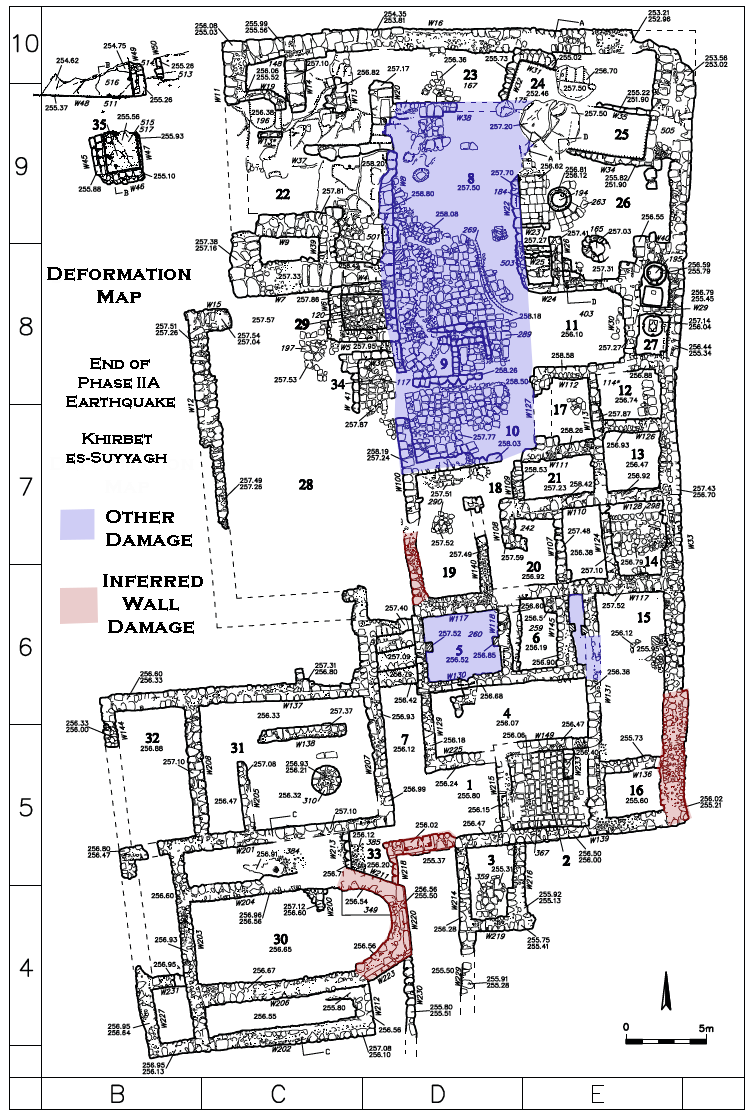 Deformation Map
Inferred Wall Damage is largely based on rebuilding evidence along with limited collapse evidence. Other Damage is either broken pottery found on floors or a significant rebuild to the large central courtyard.
modified by JW from Fig. 2.1 (Phase I and II plan) of Taxel et al (2009)
- Earthquake Archeological Effects chart
of Rodríguez-Pascua et al (2013: 221-224)
 Earthquake Archeological Effects (EAE)
Rodríguez-Pascua et al (2013: 221-224)
| Effects | Location | Image(s) | Description | Intensity |
|---|---|---|---|---|
|
Subsidiary Gate and The Large Central Courtyard
Fig. 2.1 Plan of Phase I and Phase II . Taxel et al (2009)
Fig. 2.15General reconstruction of the monastery, looking northwest Drawing by Yura Smertenko Taxel et al (2009) |
|
|
|
|
Apse of the Church
Fig. 2.1 Plan of Phase I and Phase II . Taxel et al (2009)
Fig. 2.15General reconstruction of the monastery, looking northwest Drawing by Yura Smertenko Taxel et al (2009)
Fig. 2.57Plan of the church complex. Taxel et al (2009) |
Fig. 2.58 The church (30): Above) looking north Below) Section C-C (see Fig. 2.57) through church, looking west. JW: Note asymmetric apse Taxel et al (2009)
Fig. 2.62the southern (repaired) wall of the apse (W223), looking northwest. Taxel et al (2009) |
|
|
|
Main Gate
Fig. 2.1 Plan of Phase I and Phase II . Taxel et al (2009)
Fig. 2.15General reconstruction of the monastery, looking northwest Drawing by Yura Smertenko Taxel et al (2009)
Fig. 2.15Plan of the gatehouse complex and the southern area of the monastery. JW: Broken threshold is in Square D/5 to the lower left. Note elevation differences Taxel et al (2009) |
Fig. 2.24 the threshold of Courtyard 2, looking west. Taxel et al (2009) |
|
|
|
Gatehouse
Fig. 2.1 Plan of Phase I and Phase II . Taxel et al (2009)
Fig. 2.15General reconstruction of the monastery, looking northwest Drawing by Yura Smertenko Taxel et al (2009)
Fig. 2.15Plan of the gatehouse complex and the southern area of the monastery. Taxel et al (2009) |
|
|
|
|
Southern end of Wall W33
Fig. 2.1 Plan of Phase I and Phase II . Taxel et al (2009)
Fig. 2.15General reconstruction of the monastery, looking northwest Drawing by Yura Smertenko Taxel et al (2009)
Fig. 2.15Plan of the gatehouse complex and the southern area of the monastery. JW: Rebuilt part of wall W33 is on the far right in Squares E/5-6 Taxel et al (2009) |
|
|
|
|
Wall W100 in Room 19
Fig. 2.1 Plan of Phase I and Phase II . Taxel et al (2009)
Fig. 2.15General reconstruction of the monastery, looking northwest Drawing by Yura Smertenko Taxel et al (2009)
Fig. 2.1Plan of Phase I and Phase II JW: Room 19 is in the middle (Squares D/6-7) and though Wall W100 is not labeled, it appears to be the warped southwestern wall of Room 19 . Taxel et al (2009) |
|
|
|
|
Storerooms in the Western Unit
Fig. 2.1 Plan of Phase I and Phase II . Taxel et al (2009)
Fig. 2.15General reconstruction of the monastery, looking northwest Drawing by Yura Smertenko Taxel et al (2009) |
|
|
|
|
northern doorway of the tower
Fig. 2.1 Plan of Phase I and Phase II . Taxel et al (2009)
Fig. 2.15General reconstruction of the monastery, looking northwest Drawing by Yura Smertenko Taxel et al (2009)
Fig. 2.31Plan of the tower. Taxel et al (2009) |
Fig. 2.32 the northern doorway of the tower, looking east. JW: Fracture may be due to soil creep along slope to the left Taxel et al (2009) |
|
|
- Fig. 2.24 - Broken Threshold of Courtyard 2
from Taxel et al (2009)
Fig. 2.24
the threshold of Courtyard 2, looking west.
Taxel et al (2009) - Fig. 2.24 - Deformation Map -
created by Jefferson Williams using a plan from Taxel et al (2009)
Deformation Map
Inferred Wall Damage is largely based on rebuilding evidence along with limited collapse evidence. Other Damage is either broken pottery found on floors or a significant rebuild to the large central courtyard.
modified by JW from Fig. 2.1 (Phase I and II plan) of Taxel et al (2009)
Schmuel Marco in Taxel et al (2009:186-187) suggested that seismic intensity may have reached IX (1 g) apparently largely based on the broken threshold of the Main Gate (shown in Fig. 2.24 above and not necessarily fractured in an earthquake) and rebuilding evidence which inferred wall collapses down to the foundations. Archaeoseismic evidence at the Monastery of Euthymius as reported by Hirschfeld (1993) showed evidence for a near total rebuild after it was presumably destroyed in one of the Jordan Valley Quake(s) of 659/660 CE. Although direct archaeoseismic evidence was not observed at the Monastery of Euthymius, the contemporary Maronite Chronicle reported that the Monastery of Euthymius collapsed during this earthquake - which supports the idea that a near total rebuild supports such a high level of local seismic intensity. However, the Monastery of Euthymius is closer to active Jordan Valley faults that seem to have broken during the Jordan Valley Quake(s) which means that Khirbet es-Suyyagh, further away from these faults, would have likely experienced lower levels of intensity during this event(s). This would explain why there were repairs at Khirbet es-Suyyagh rather than a complete rebuild. Given the distance between Khirbet es-Suyyagh and the active faults of Jordan Valley and the Dead Sea, Schmuel Marco in Taxel et al (2009:186-187) suggested that such an elevated intensity estimate (guesstimate ?) of IX (1 g) could be explained by a site effect or being above the hypocenter when the Quake struck (e..g in a blind thrust scenario). While a site effect is possible as it is described as being located on a spur, the Deformation Map (see in Figures above) suggests that North-South walls were preferentially damaged which is not what one would suspect above a hypocenter where inclination and collapse typically do not display directional patterns. Such directional patterns, which seem to be evident at Khirbet es-Suyyagh, are what one would expect at some distance form the epicenter (e.g. see Korzhenkov and Mazor, 1999).