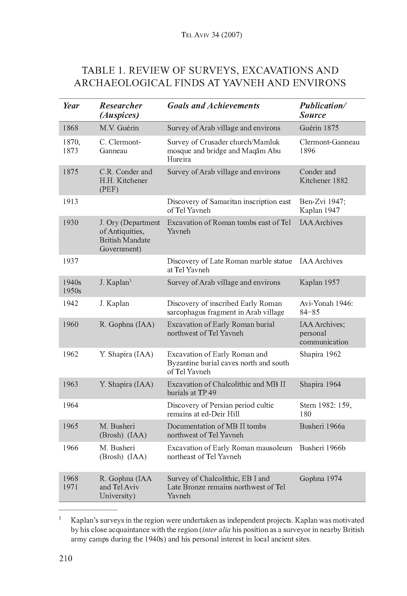
Yavne
 Yavne
Yavneclick on image to explore this site on a new tab in govmap.gov.il
| Transliterated Name | Language | Name |
|---|---|---|
| Yavne | Hebrew | יַבְנֶה |
| Jabneh | English | |
| Jamnia | Greek | Ἰαμνία |
| Jamnia | Latin | |
| Iamnia | ||
| Yibna | Arabic | يبنى |
| Yubna | Arabic | يبنى |
| Ibelin | Crusader (Frankish?) |


- Fig. 2 - Aerial View of
Tel Yavneh from Fischer and Taxel (2007)
 Fig. 2
Tel Yavneh, aerial view, looking north.
Fischer and Taxel (2007) - Yavne in Google Earth
 Yavne
Yavne
click on image to explore this site on a new tab in Google Earth - Yavne on govmap.gov.il
Yavne
click on image to explore this site on a new tab in govmap.gov.il
- Annotated Aerial View of
Yavne from BibleWalks.com
- Map 2 - Tel Yavneh and
environs from Fischer and Taxel (2007)

Map 2
Tel Yavneh and environs
- TP 49, excav., Shapira ’62(?), ’63
- MBII tombs, documen., Busheri ’66
- Excav., Dagot ’03
- Ed-Deir Hill, excav., Honigman ’78, Kletter ’02
- Excav., Kletter ’00–’01
- Maqam Abu Hureira
- Excav., Feldstein and Shmueli ’93
- Maqam ash-Sheikh Salim
- Excav., Levi ’90
- Mamluk bridge, excav., Busheri ’66
- Excav., Meron ’72
- Excav.,Barash ’99
- Quarry cave
- Excav., Levi ’88
- Excav., Levi ’91
- Excav., Levi ’91
- Excav., Eliaz ’99
- Excav.,Velednizki ’00;
- Excav., Sion ’00
- Remains, Byzantine public building
- Crusader fort, excav., Bahat ’05
- Crusader church/Mamluk mosque
- Excav., Levi ’87
- Excav., Eliaz ’99
Fischer and Taxel (2007) - Fig. 1 Location Map from
Yannai (2014)
 Figure 1
Location Map
Yannai (2014)

- Annotated Aerial View of
Yavne from BibleWalks.com
- Map 2 - Tel Yavneh and
environs from Fischer and Taxel (2007)
Map 2
Tel Yavneh and environs
- TP 49, excav., Shapira ’62(?), ’63
- MBII tombs, documen., Busheri ’66
- Excav., Dagot ’03
- Ed-Deir Hill, excav., Honigman ’78, Kletter ’02
- Excav., Kletter ’00–’01
- Maqam Abu Hureira
- Excav., Feldstein and Shmueli ’93
- Maqam ash-Sheikh Salim
- Excav., Levi ’90
- Mamluk bridge, excav., Busheri ’66
- Excav., Meron ’72
- Excav.,Barash ’99
- Quarry cave
- Excav., Levi ’88
- Excav., Levi ’91
- Excav., Levi ’91
- Excav., Eliaz ’99
- Excav.,Velednizki ’00;
- Excav., Sion ’00
- Remains, Byzantine public building
- Crusader fort, excav., Bahat ’05
- Crusader church/Mamluk mosque
- Excav., Levi ’87
- Excav., Eliaz ’99
Fischer and Taxel (2007) - Fig. 1 Location Map from
Yannai (2014)
Figure 1
Location Map
Yannai (2014)
- Fig. 2 Plan of Area A
from Yannai (2014)
 Figure 2
Area A, plan
Yannai (2014)
- Fig. 2 Plan of Area A
from Yannai (2014)
Figure 2
Area A, plan
Yannai (2014)
- Fig. 9 Plan of Area C
(the kiln complex) from Yannai (2014)
 Figure 9
Area C, the kiln complex, Plan
Yannai (2014)
- Fig. 9 Plan of Area C
(the kiln complex) from Yannai (2014)
Figure 9
Area C, the kiln complex, Plan
Yannai (2014)
- Fig. 5 Master Aerial Photo
of seismic destruction in the kiln complex (Area C) from Langgut et al (2015)
 Figure 5
- An aerial photo of one of the clusters of the unique pottery kiln complex. The kilns were connected by barrel-shaped and covered tunnels with a common entrance.
- Fallen columns.
- End of burning process.
- Fig. 10 Aerial photograph of
the kiln complex from Yannai (2014)
 Figure 10
Area C, the kiln complex, aerial photograph looking northwest
Yannai (2014) - Fig. 13 Aerial photograph of
fallen columns from Yannai (2014)
 Figure 13
Area C, the stone colonnaded building after the earthquake, aerial view looking northwest
Yannai (2014) - Fig. 6 The kiln during the
excavation from Langgut et al (2015)
 Figure 6
The kiln during the excavation. We were able to collect four in situ sealed dust samples for palynological investigation from the kiln’s floor, underneath unbroken ceramic vessels. An additional sample was collected 2-3 cm above the kiln’s floor. The black arrow points to the debris/clay fragments (which were used to cover the kiln during the heating process) and were deposited after the earthquake.
Langgut et al (2015)
- Fig. 5 Master Aerial Photo
of seismic destruction in the kiln complex (Area C) from Langgut et al (2015)
Figure 5
- An aerial photo of one of the clusters of the unique pottery kiln complex. The kilns were connected by barrel-shaped and covered tunnels with a common entrance.
- Fallen columns.
- End of burning process.
- Fig. 10 Aerial photograph of
the kiln complex from Yannai (2014)
Figure 10
Area C, the kiln complex, aerial photograph looking northwest
Yannai (2014) - Fig. 13 Aerial photograph of
fallen columns from Yannai (2014)
Figure 13
Area C, the stone colonnaded building after the earthquake, aerial view looking northwest
Yannai (2014) - Fig. 6 The kiln during the
excavation from Langgut et al (2015)
Figure 6
The kiln during the excavation. We were able to collect four in situ sealed dust samples for palynological investigation from the kiln’s floor, underneath unbroken ceramic vessels. An additional sample was collected 2-3 cm above the kiln’s floor. The black arrow points to the debris/clay fragments (which were used to cover the kiln during the heating process) and were deposited after the earthquake.
Langgut et al (2015)
- Fig. 7 Possible sequence
of events in the kiln from Langgut et al (2015)
 Figure 7 - Possible sequence of events in the kiln.
- Construction of the kiln; laying the freshly made pots at the bottom.
- Covering with debris/clay fragments; igniting fire, heating.
- End of burning process.
- Removing debris/clay fragments; beginning of vessels’ cooling process. Pollen penetrated the kiln (with the cooling air) and was deposited on the floor, but was partially damaged due to the still high temperatures (as evidenced by the group of degraded palynomorphs D charred pollen). Pollen (of spring bloomers) penetrated and was deposited on the kiln’s floor when normal temperatures prevailed in the kiln (and was therefore well preserved).
- An earthquake - the kiln collapsed.
- The burial of the kiln: sediments were deposited covering the burnt material.
- Fig. 7 Possible sequence
of events in the kiln from Langgut et al (2015)
Figure 7 - Possible sequence of events in the kiln.
- Construction of the kiln; laying the freshly made pots at the bottom.
- Covering with debris/clay fragments; igniting fire, heating.
- End of burning process.
- Removing debris/clay fragments; beginning of vessels’ cooling process. Pollen penetrated the kiln (with the cooling air) and was deposited on the floor, but was partially damaged due to the still high temperatures (as evidenced by the group of degraded palynomorphs D charred pollen). Pollen (of spring bloomers) penetrated and was deposited on the kiln’s floor when normal temperatures prevailed in the kiln (and was therefore well preserved).
- An earthquake - the kiln collapsed.
- The burial of the kiln: sediments were deposited covering the burnt material.
- Fig. 10 Aerial photograph of
the kiln complex from Yannai (2014)
Figure 10
Area C, the kiln complex, aerial photograph looking northwest
Yannai (2014) - Fig. 5 Master Aerial Photo
of seismic destruction in the kiln complex (Area C) from Langgut et al (2015)
Figure 5
- An aerial photo of one of the clusters of the unique pottery kiln complex. The kilns were connected by barrel-shaped and covered tunnels with a common entrance.
- Fallen columns.
- End of burning process.
- Fig. 13 Aerial photograph of
fallen columns from Yannai (2014)
Figure 13
Area C, the stone colonnaded building after the earthquake, aerial view looking northwest
Yannai (2014) - Fig. 6 The kiln during the
excavation from Langgut et al (2015)
Figure 6
The kiln during the excavation. We were able to collect four in situ sealed dust samples for palynological investigation from the kiln’s floor, underneath unbroken ceramic vessels. An additional sample was collected 2-3 cm above the kiln’s floor. The black arrow points to the debris/clay fragments (which were used to cover the kiln during the heating process) and were deposited after the earthquake.
Langgut et al (2015) - Fig. 7 Possible sequence
of events in the kiln from Langgut et al (2015)
Figure 7 - Possible sequence of events in the kiln.
- Construction of the kiln; laying the freshly made pots at the bottom.
- Covering with debris/clay fragments; igniting fire, heating.
- End of burning process.
- Removing debris/clay fragments; beginning of vessels’ cooling process. Pollen penetrated the kiln (with the cooling air) and was deposited on the floor, but was partially damaged due to the still high temperatures (as evidenced by the group of degraded palynomorphs D charred pollen). Pollen (of spring bloomers) penetrated and was deposited on the kiln’s floor when normal temperatures prevailed in the kiln (and was therefore well preserved).
- An earthquake - the kiln collapsed.
- The burial of the kiln: sediments were deposited covering the burnt material.
| Effect | Location | Image(s) | Description |
|---|---|---|---|
| Complete destruction of buildings - Collapsed Walls | Kiln Complex (Area C)
Figure 5
|
|
|
| Fallen and Oriented Columns | Kiln Complex (Area C)
Figure 5
|
Figure 13 Area C, the stone colonnaded building after the earthquake, aerial view looking northwest Yannai (2014) |
|
| Broken Pottery in fallen position | Kiln Complex (Area C)
Figure 5
|
Figure 6 The kiln during the excavation. We were able to collect four in situ sealed dust samples for palynological investigation from the kiln’s floor, underneath unbroken ceramic vessels. An additional sample was collected 2-3 cm above the kiln’s floor. The black arrow points to the debris/clay fragments (which were used to cover the kiln during the heating process) and were deposited after the earthquake. Langgut et al (2015)
Figure 7 - Possible sequence of events in the kiln.
|
|
| Effect | Location | Image(s) | Description |
|---|---|---|---|
| Collapsed Walls | Sub-Area A2
Figure 2 Area A, plan Yannai (2014) |
|
|
| Foundation damage | Sub-Area A2
Figure 2 Area A, plan Yannai (2014) |
|
- Modified by JW from Fig. 9 of Yannai (2014)
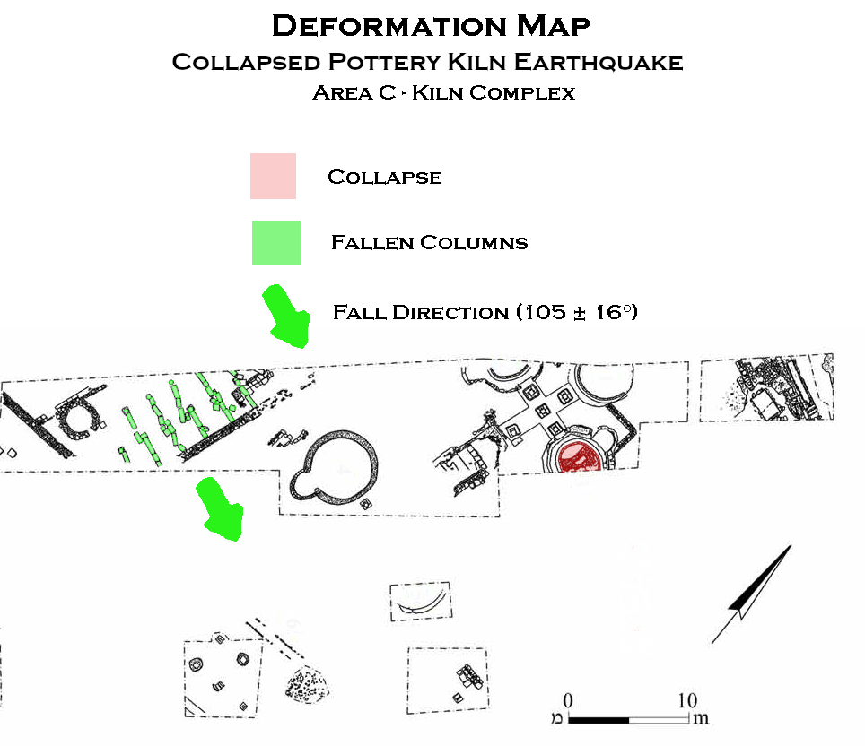 Deformation Map
Click on image to open in a new tab
Modified by JW from Fig. 9 of Yannai (2014)
- Earthquake Archeological Effects chart
of Rodríguez-Pascua et al (2013: 221-224)
 Earthquake Archeological Effects (EAE)
Rodríguez-Pascua et al (2013: 221-224)
| Effect | Location | Image(s) | Description | Intensity |
|---|---|---|---|---|
| Complete destruction of buildings - Collapsed Walls | Kiln Complex (Area C)
Figure 5
|
|
VIII + | |
| Fallen and Oriented Columns | Kiln Complex (Area C)
Figure 5
|
Figure 13 Area C, the stone colonnaded building after the earthquake, aerial view looking northwest Yannai (2014) |
|
V + |
| Broken Pottery in fallen position | Kiln Complex (Area C)
Figure 5
|
Figure 6 The kiln during the excavation. We were able to collect four in situ sealed dust samples for palynological investigation from the kiln’s floor, underneath unbroken ceramic vessels. An additional sample was collected 2-3 cm above the kiln’s floor. The black arrow points to the debris/clay fragments (which were used to cover the kiln during the heating process) and were deposited after the earthquake. Langgut et al (2015)
Figure 7 - Possible sequence of events in the kiln.
|
|
VII + |
- Fig. 9 Plan of Area C
(the kiln complex) from Yannai (2014)
Figure 9
Area C, the kiln complex, Plan
Yannai (2014) - Fig. 10 Aerial photograph of
the kiln complex from Yannai (2014)
Figure 10
Area C, the kiln complex, aerial photograph looking northwest
Yannai (2014) - Fig. 5 Master Aerial Photo
of seismic destruction in the kiln complex (Area C) from Langgut et al (2015)
Figure 5
- An aerial photo of one of the clusters of the unique pottery kiln complex. The kilns were connected by barrel-shaped and covered tunnels with a common entrance.
- Fallen columns.
- End of burning process.
- Fig. 13 Aerial photograph of
fallen columns from Yannai (2014)
Figure 13
Area C, the stone colonnaded building after the earthquake, aerial view looking northwest
Yannai (2014)
In a peripheral building to the west of the kiln, five fallen columns "all paralleling an east-west orientation (Figure 5a and 5b)" were discovered. In Fig. 9 Yannai (2014) shows the columns fell in an ESE direction which, due to inertia forces, might suggest an epicenter in the same ESE direction. This direction points towards the southern Jordan valley or the north Dead Sea which the source documents suggest is the probable location of the epicenter of the 659/660 CE Jordan Valley Quake(s).
In discussing 31 fallen columns at the site, Langgut et al (2015) suggested that the fallen columns were part of a colonnade that was oriented in an approximate N-S direction. They cautioned that the direction of column fall (105 ± 16 degrees) was not necessarily indicative of epicentral direction.
Slow deterioration of the colonnade is likely to result with columns falling in different directions. Aligned fallen columns are found in many earthquake-affected sites (Stiros 1996; Marco 2008; Hinzen et al. 2011; Rodríguez-Pascua et al. 2011; Sintubin 2011) and we propose that the same cause led to similar results in Yavneh. The colonnade’s azimuth is 010-190 degrees and all the columns fell eastward (Figure 5b). The average azimuth of 31 column segments is 105 ± 16 degrees Simulations using strong-motion records of modern earthquakes show only little correlation between falling directions and back azimuth to the wave source (Hinzen 2009, 2011). This requires that the individual columns were connected, possibly with wooden beams that were not preserved, and unified the falling direction. We therefore regard the columns as evidence for earthquake as a trigger for the destruction of the site, but they cannot serve as a reliable indicator for determining the source location.
- Earthquake Archeological Effects chart
of Rodríguez-Pascua et al (2013: 221-224)
Earthquake Archeological Effects (EAE)
Rodríguez-Pascua et al (2013: 221-224)
| Effect | Location | Image(s) | Description | Intensity |
|---|---|---|---|---|
| Collapsed Walls | Sub-Area A2
Figure 2 Area A, plan Yannai (2014) |
|
VIII + | |
| Foundation damage | Sub-Area A2
Figure 2 Area A, plan Yannai (2014) |
|
VIII + |