Heshbon
APAAME
- Reference: APAAME_20211022_FB-0048
- Photographer: Firas Bqain
- Credit: Aerial Photographic Archive for Archaeology in the Middle East
- Copyright: Creative Commons Attribution-Noncommercial-No Derivative Works
Click photo for high res magnifiable image
| Transliterated Name | Language | Name |
|---|---|---|
| Hesban | | |
| Heshbon | Biblical Hebrew | חשבון |
| Heshbon | Arabic | حشبون |
| Tell Hisban | Arabic | تيلل هيسبان |
| Tell Ḥesbān | Arabic | تيلل هيسبان |
| Esebus | Latin | |
| Esbus | Latin | |
| Hesbonitis | Greek | Εσεβωνιτις |
| Hesebon | Ancient Greek | Ἐσεβών |
| Esbous | Ancient Greek | Ἐσβούς |
| Exbous | Ancient Greek | Ἔξβους |
| Esbouta | Ancient Greek | Ἐσβούτα |
| Essebōn | Ancient Greek | Ἐσσεβών |
| Esb[untes] |
- Heshbon in Google Earth
 Heshbon
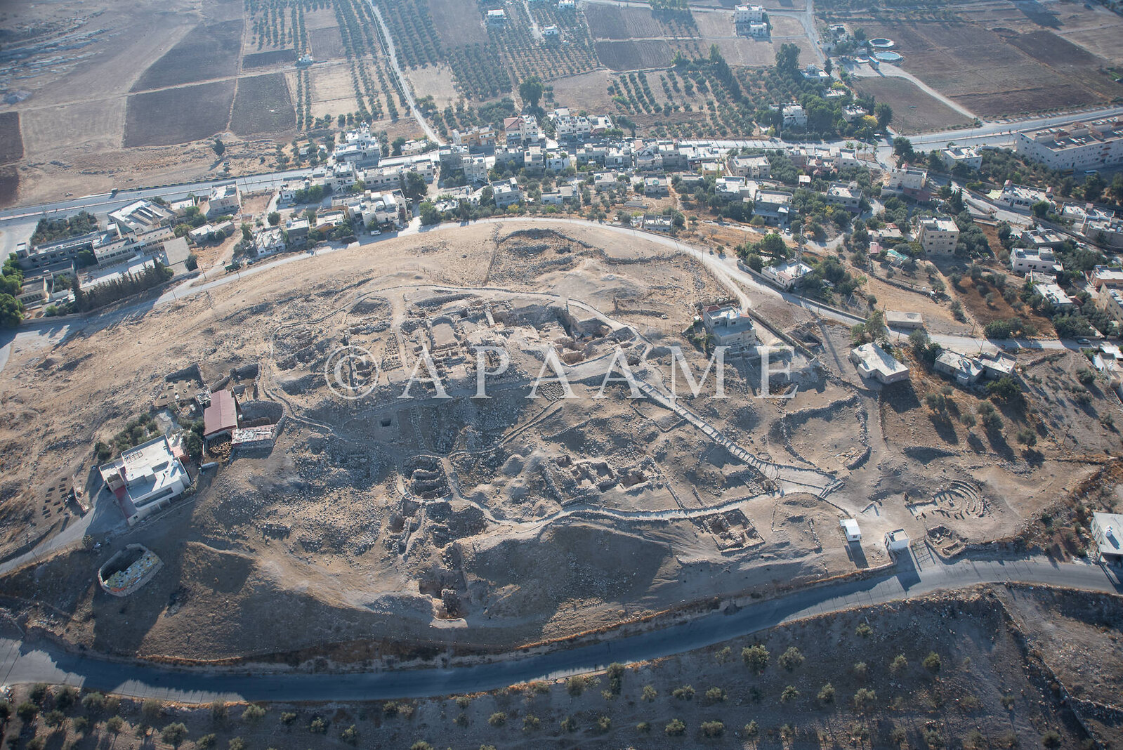
click on image to explore this site on a new tab in Google Earth - Fig. 3 - Aerial Photo of Heshbon
from Walker et al (2017)
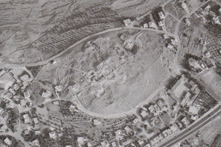 Figure 3
Aerial photo of Tall Hisban a mediaeval village below (courtesy of Ivan LaBianca)
Walker et al (2017)
- Fig. 1.2 Site Plan with
excavation areas from Ray (2001)
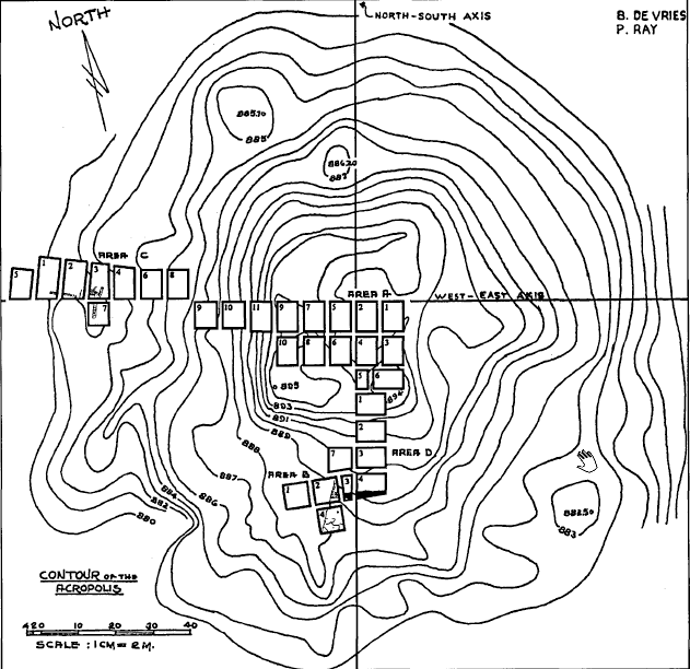 Fig. 1.2
Plan of Tell Hesban with Excavation areas
click on image to open in a new tab
Ray (2001) - Site Plan with excavation
areas from Stern et. al. (1993 v. 2)
 Heshbon: map of the mound and excavation areas.
Stern et. al. (1993 v. 2) - Fig. 2 - Areas of excavations
at Tell Heshbon from Walker and LaBianca (2003)
 Figure 2
Areas of excavations (Bert de Vries, Calvin College; Paul Ray, Jr., Andrews University; Ernest Cowles, Oklahoma State University; and Marvin Bowen, Andrews University).
Walker and LaBianca (2003) - Fig. 2 - Area Map from
Walker et al (2017)
 Figure 2
Fields of excavation (courtesy of Qutaiba Dasouqi)
Walker et al (2017)
- Fig. 1.2 Site Plan with
excavation areas from Ray (2001)
Fig. 1.2
Plan of Tell Hesban with Excavation areas
click on image to open in a new tab
Ray (2001) - Site Plan with excavation
areas from Stern et. al. (1993 v. 2)
Heshbon: map of the mound and excavation areas.
Stern et. al. (1993 v. 2) - Fig. 2 - Areas of excavations
at Tell Heshbon from Walker and LaBianca (2003)
Figure 2
Areas of excavations (Bert de Vries, Calvin College; Paul Ray, Jr., Andrews University; Ernest Cowles, Oklahoma State University; and Marvin Bowen, Andrews University).
Walker and LaBianca (2003) - Fig. 2 - Area Map from
Walker et al (2017)
Figure 2
Fields of excavation (courtesy of Qutaiba Dasouqi)
Walker et al (2017)
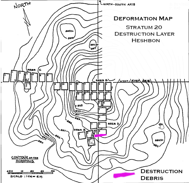
- Fig. 5.10 Stratum 20
Bedrock Trench from Ray (2001)
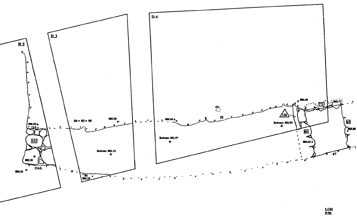 Fig. 5.10
Stratum 20 Bedrock Trench (with Stratum 19 Wall and Stratum 18 House)
click on image to open in a new tab
Ray (2001)
- Fig. 5.10 Stratum 20
Bedrock Trench from Ray (2001)
Fig. 5.10
Stratum 20 Bedrock Trench (with Stratum 19 Wall and Stratum 18 House)
click on image to open in a new tab
Ray (2001)
- Fig. 3.1 Stratum 14
Significant Remains from Mitchel (1992)
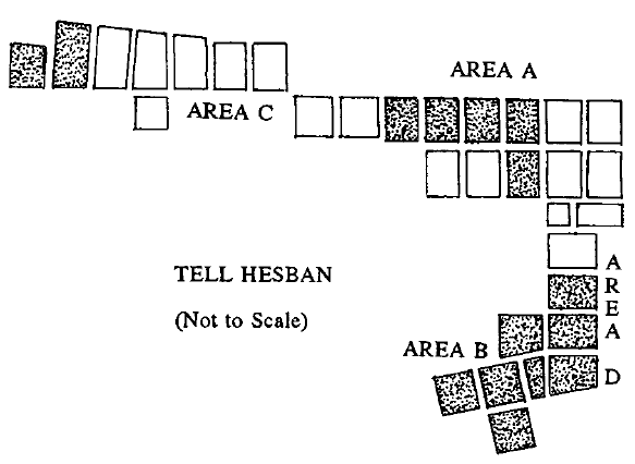 Fig. 3.1
Stratum 14 Significant Remains
click on image to open in a new tab
Mitchel (1992)
- Fig. 3.1 Stratum 14
Significant Remains from Mitchel (1992)
Fig. 3.1
Stratum 14 Significant Remains
click on image to open in a new tab
Mitchel (1992)
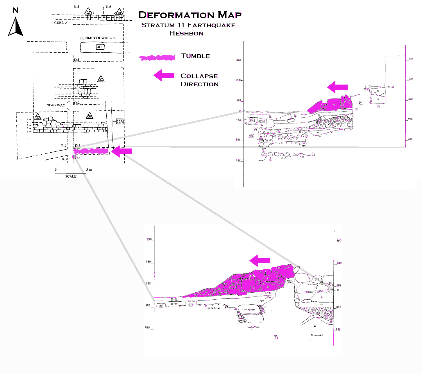
- Fig. 6.1 Stratum 11
Significant Remains from Mitchel (1992)
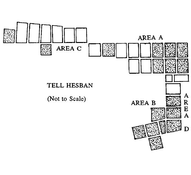 Fig. 6.1
Stratum 11 Significant Remains
click on image to open in a new tab
Mitchel (1992) - Fig. 6.3 Collapsed
Monumental Stairway of Stratum 11 from Mitchel (1992)
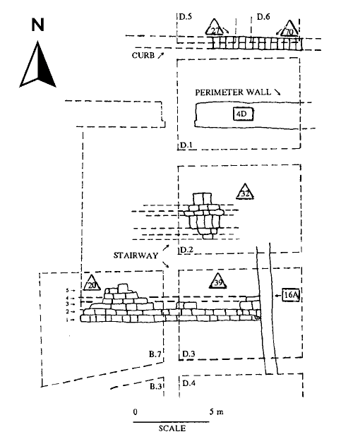 Fig. 6.3
Stratum 11 Features in Area D
click on image to open in a new tab
Mitchel (1992)
- Fig. 6.1 Stratum 11
Significant Remains from Mitchel (1992)
Fig. 6.1
Stratum 11 Significant Remains
click on image to open in a new tab
Mitchel (1992) - Fig. 6.3 Collapsed
Monumental Stairway of Stratum 11 from Mitchel (1992)
Fig. 6.3
Stratum 11 Features in Area D
click on image to open in a new tab
Mitchel (1992)
- Fig. 4 - Floor plan of Mamluk
and Umayyad buildings from Walker and LaBianca (2003)
 Figure 4
Floor plan of Mamluk and Umayyad buildings, 2001 season (map by Ernest Cowles, Oklahoma State University). The bathhouse is the three-room structure occupying A08.
Walker and LaBianca (2003)
- Fig. 4 - Floor plan of Mamluk
and Umayyad buildings from Walker and LaBianca (2003)
Figure 4
Floor plan of Mamluk and Umayyad buildings, 2001 season (map by Ernest Cowles, Oklahoma State University). The bathhouse is the three-room structure occupying A08.
Walker and LaBianca (2003)
- Fig. 6.4 Square D.3
South Balk with Tumble Layer Colored from Mitchel (1992)
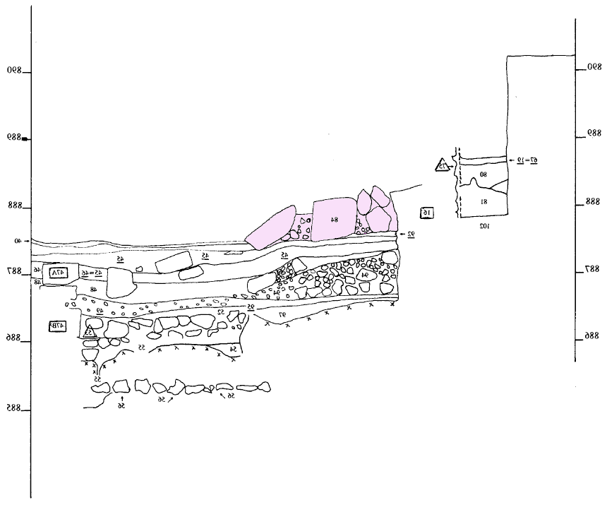 Fig. 6.4
Square D.3, South Balk
click on image to open in a new tab
Mitchel (1992) - Fig. 6.5 Square D.4
North Balk with Tumble Layer Colored from Mitchel (1992)
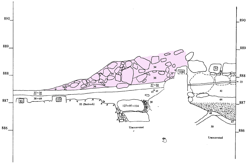 Fig. 6.5
Square D.4, North Balk
click on image to open in a new tab
Mitchel (1992) - Fig. 6.4 Square D.3
South Balk from Mitchel (1992)
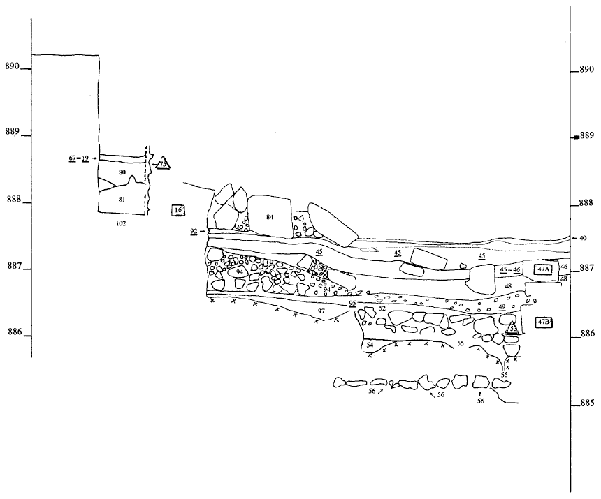 Fig. 6.4
Square D.3, South Balk
click on image to open in a new tab
Mitchel (1992) - Fig. 6.5 Square D.4
North Balk from Mitchel (1992)
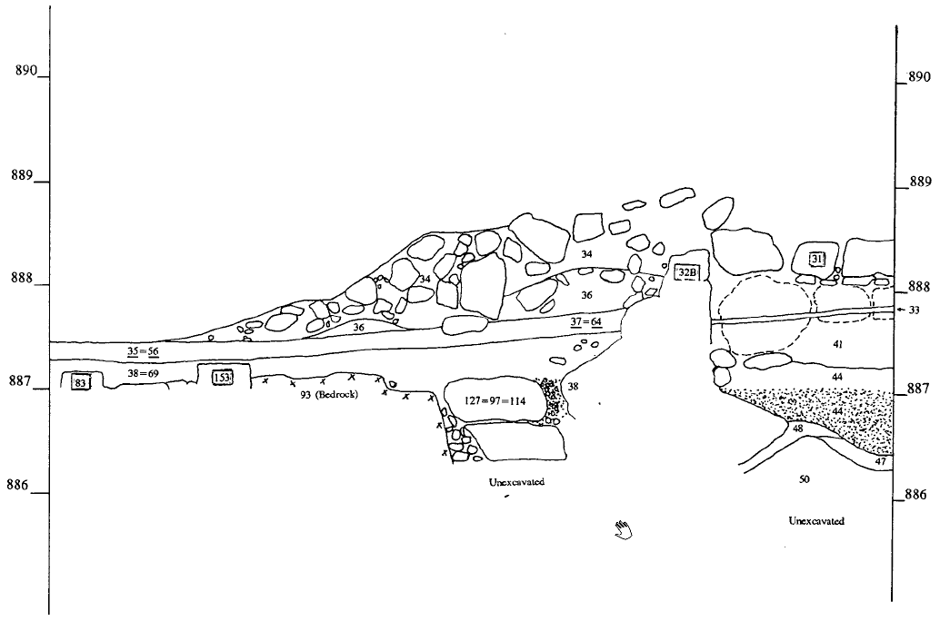 Fig. 6.5
Square D.4, North Balk
click on image to open in a new tab
Mitchel (1992)
- Fig. 6.4 Square D.3
South Balk with Tumble Layer Colored from Mitchel (1992)
Fig. 6.4
Square D.3, South Balk
click on image to open in a new tab
Mitchel (1992) - Fig. 6.5 Square D.4
North Balk with Tumble Layer Colored from Mitchel (1992)
Fig. 6.5
Square D.4, North Balk
click on image to open in a new tab
Mitchel (1992) - Fig. 6.4 Square D.3
South Balk from Mitchel (1992)
Fig. 6.4
Square D.3, South Balk
click on image to open in a new tab
Mitchel (1992) - Fig. 6.5 Square D.4
North Balk from Mitchel (1992)
Fig. 6.5
Square D.4, North Balk
click on image to open in a new tab
Mitchel (1992)
- Pl. 6.13 Square D.3
South Balk, West Section (A.I. Enhanced) from Mitchel (1992)
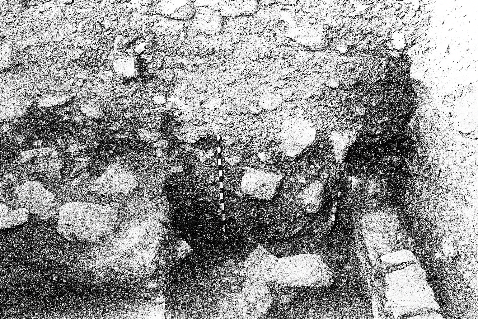 Plate 6.13
Square D.3, South Balk, West Section
A.I. Enhanced
click on image to open in a new tab
Mitchel (1992) - Pl. 6.14 Square D.4
North Balk (A.I. Enhanced) from Mitchel (1992)
 Plate 6.14
Square D.4, North Balk
A.I. Enhanced
click on image to open in a new tab
Mitchel (1992) - Pl. 6.15
Huwwar Layers
South of Stairway (A.I. Enhanced) from Mitchel (1992)
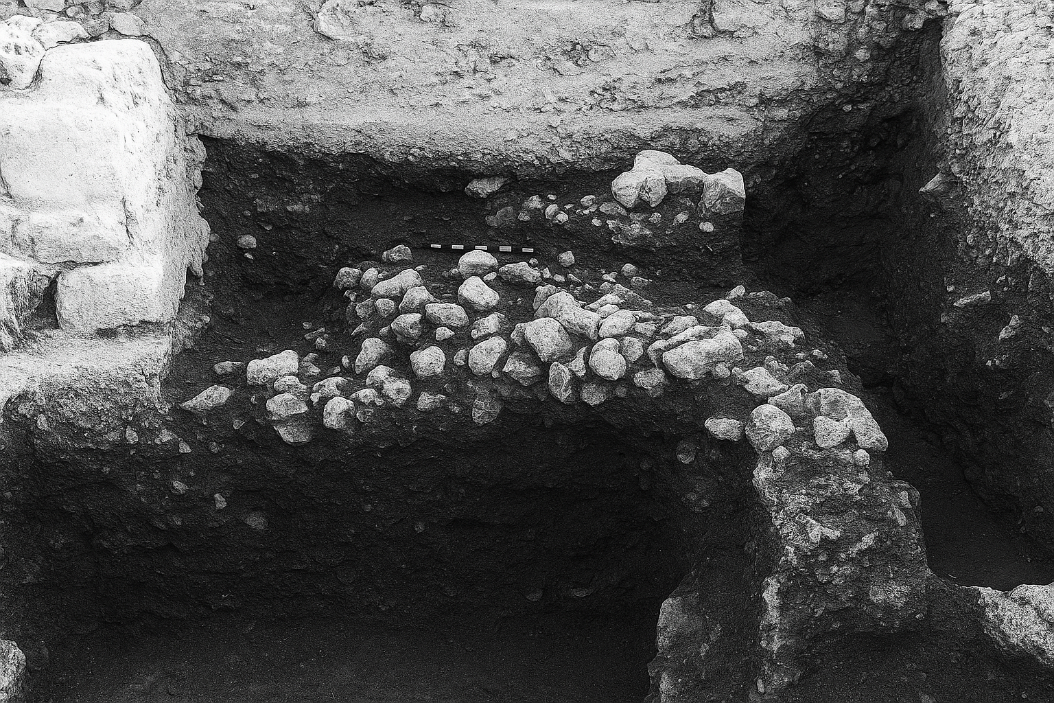 Plate 6.15
Huwwar Layers South of Stairway
A.I. Enhanced
click on image to open in a new tab
Mitchel (1992) - Pl. 25A East Margin
of Monumental Stairway in Square D.3 (A.I. Enhanced) from Mitchel (1980)
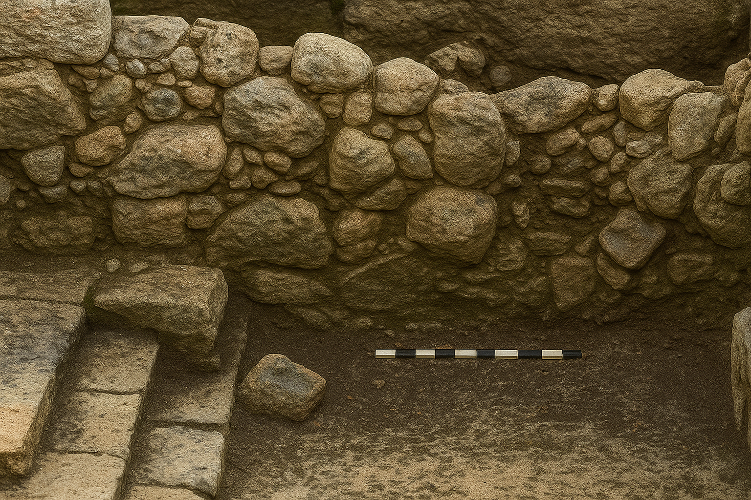 Plate 25A
East Margin of Monumental Stairway, D.3. View East
A.I. Enhanced
click on image to open in a new tab
Mitchel (1980) - Pl. 6.13 Square D.3
South Balk, West Section from Mitchel (1992)
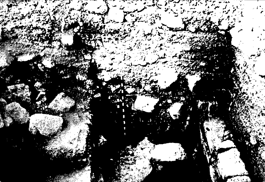 Plate 6.13
Square D.3, South Balk, West Section
click on image to open in a new tab
Mitchel (1992) - Pl. 6.14 Square D.4
North Balk from Mitchel (1992)
 Plate 6.14
Square D.4, North Balk
click on image to open in a new tab
Mitchel (1992) - Pl. 6.15
Huwwar Layers
South of Stairway from Mitchel (1992)
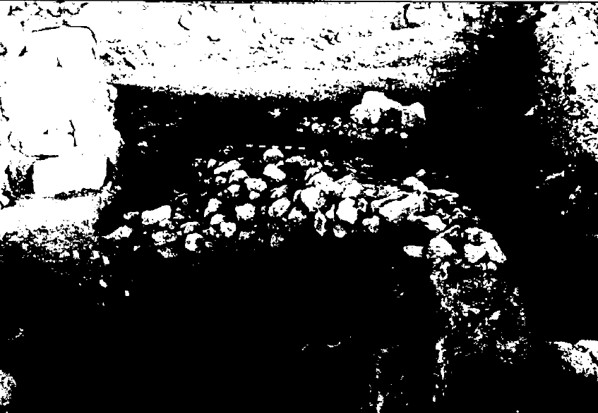 Plate 6.15
Huwwar Layers South of Stairway
click on image to open in a new tab
Mitchel (1992) - Pl. 25A East Margin
of Monumental Stairway in Square D.3 from Mitchel (1980)
 Plate 25A
East Margin of Monumental Stairway, D.3. View East
click on image to open in a new tab
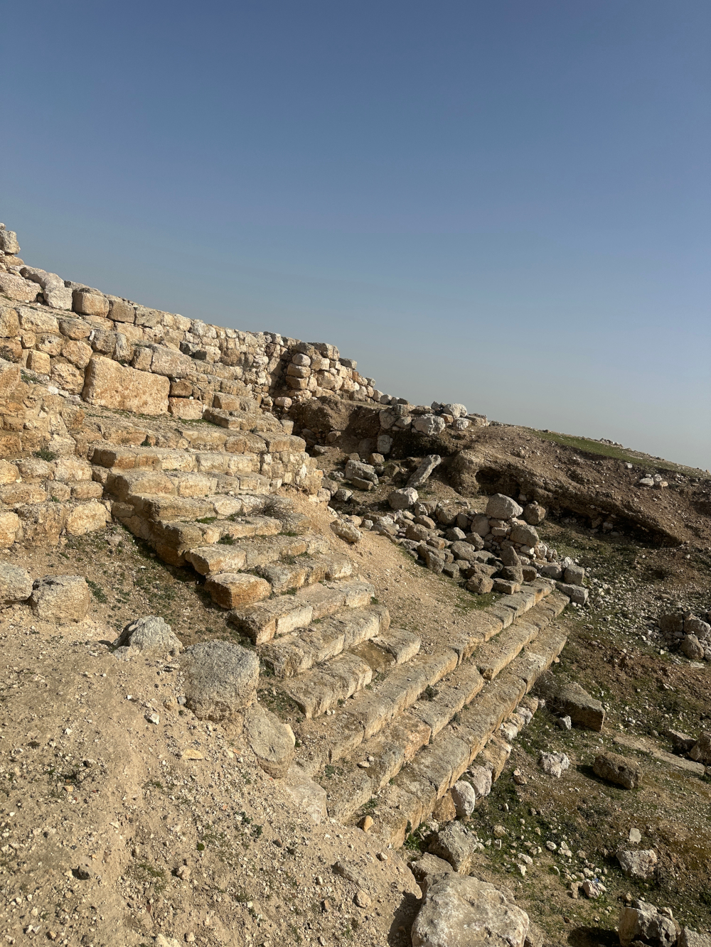
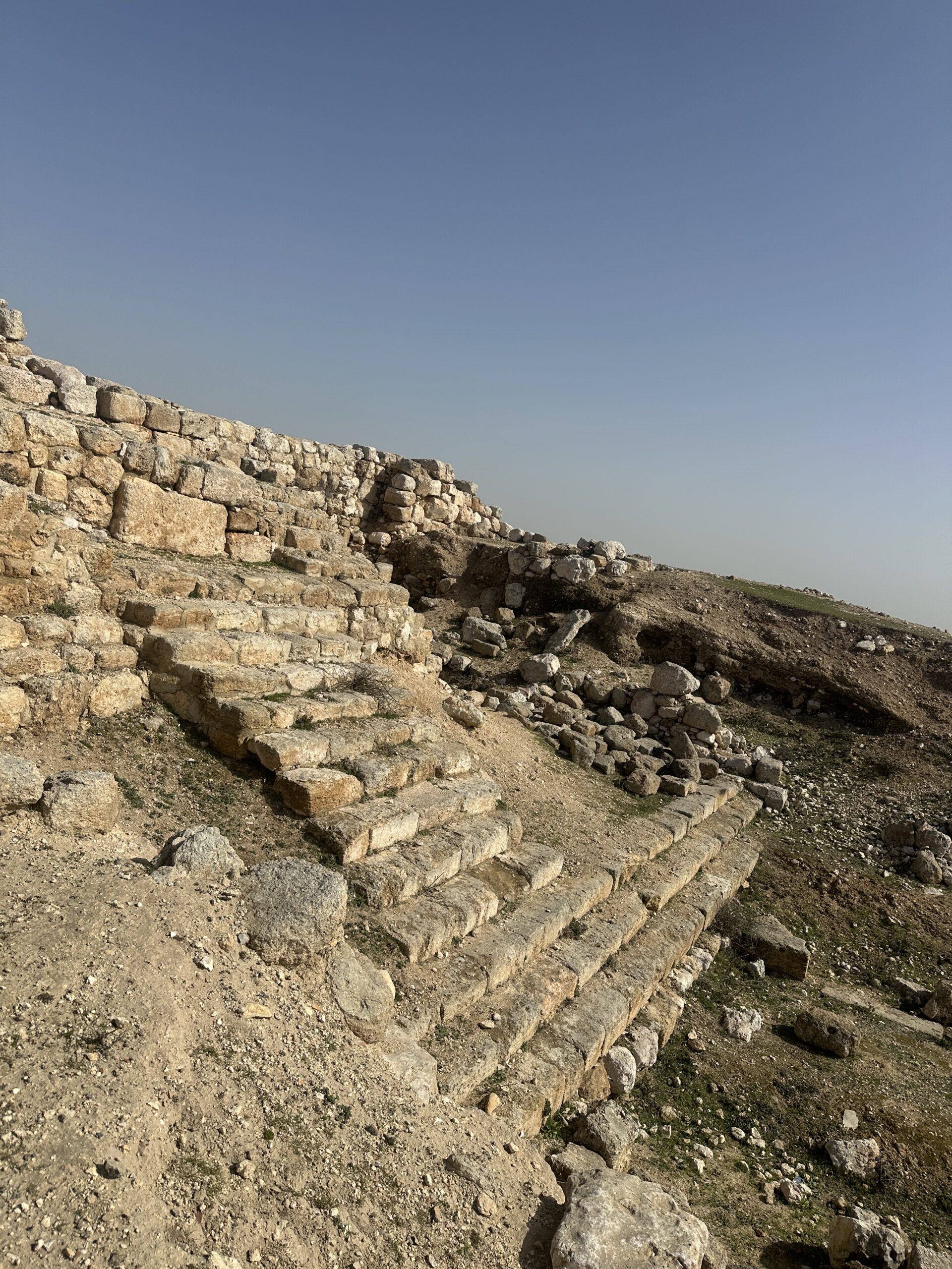
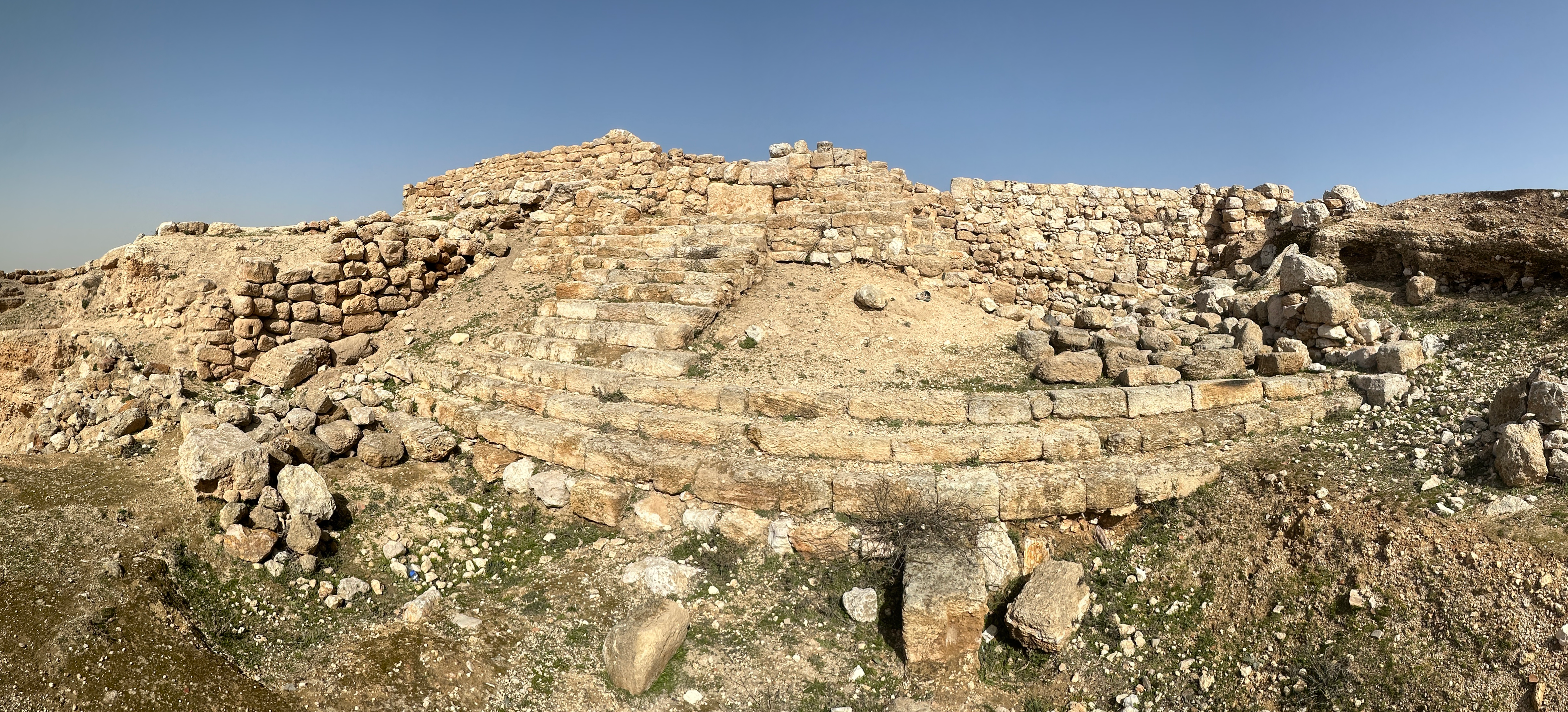
Mitchel (1980) - Stairs at Heshbon
- photo by JW
 Stairs at Hebron
Click on image to open in a new tab
Photo by Jefferson Williams - 27 Jan. 2026 - Stairs at Heshbon
- photo by JW
 Stairs at Hebron
Click on image to open in a new tab
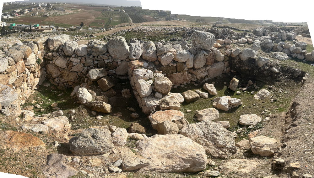
Photo by Jefferson Williams - 27 Jan. 2026 - Rooms N.1 and N.2 (?)
- photo by JW
 Rooms N.1 and N.2 (?)
Click on image to open in a new tab
Photo by Jefferson Williams - 27 Jan. 2026
- Pl. 6.13 Square D.3
South Balk, West Section (A.I. Enhanced) from Mitchel (1992)
Plate 6.13
Square D.3, South Balk, West Section
A.I. Enhanced
click on image to open in a new tab
Mitchel (1992) - Pl. 6.14 Square D.4
North Balk (A.I. Enhanced) from Mitchel (1992)
Plate 6.14
Square D.4, North Balk
A.I. Enhanced
click on image to open in a new tab
Mitchel (1992) - Pl. 6.15
Huwwar Layers
South of Stairway (A.I. Enhanced) from Mitchel (1992)
Plate 6.15
Huwwar Layers South of Stairway
A.I. Enhanced
click on image to open in a new tab
Mitchel (1992) - Pl. 25A East Margin
of Monumental Stairway in Square D.3 (A.I. Enhanced) from Mitchel (1980)
Plate 25A
East Margin of Monumental Stairway, D.3. View East
A.I. Enhanced
click on image to open in a new tab
Mitchel (1980) - Pl. 6.13 Square D.3
South Balk, West Section from Mitchel (1992)
Plate 6.13
Square D.3, South Balk, West Section
click on image to open in a new tab
Mitchel (1992) - Pl. 6.14 Square D.4
North Balk from Mitchel (1992)
Plate 6.14
Square D.4, North Balk
click on image to open in a new tab
Mitchel (1992) - Pl. 6.15
Huwwar Layers
South of Stairway from Mitchel (1992)
Plate 6.15
Huwwar Layers South of Stairway
click on image to open in a new tab
Mitchel (1992) - Pl. 25A East Margin
of Monumental Stairway in Square D.3 from Mitchel (1980)
Plate 25A
East Margin of Monumental Stairway, D.3. View East
click on image to open in a new tab
Mitchel (1980) - Stairs at Heshbon
- photo by JW
Stairs at Hebron
Click on image to open in a new tab
Photo by Jefferson Williams - 27 Jan. 2026 - Stairs at Heshbon
- photo by JW
Stairs at Hebron
Click on image to open in a new tab
Photo by Jefferson Williams - 27 Jan. 2026 - Rooms N.1 and N.2 (?)
- photo by JW
Rooms N.1 and N.2 (?)
Click on image to open in a new tab
Photo by Jefferson Williams - 27 Jan. 2026
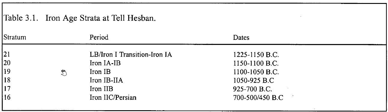 Table 3.1
Iron Age Strata at Tell Hesban
Click on image to open in a new tab
Ray (2001)
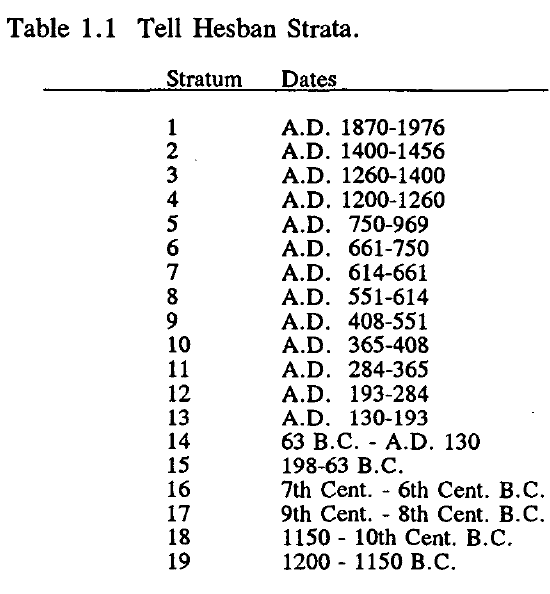 Table 1.1
Tell Hesban Strata
Click on image to open in a new tab
Mitchel (1992)
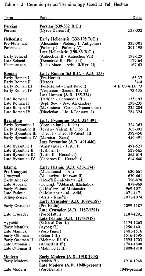 Table 1.2
Common Ceramic-Period Terminology used at Tell Hesban
Click on image to open in a new tab
Mitchel (1992)
- from Storfjell (1993)
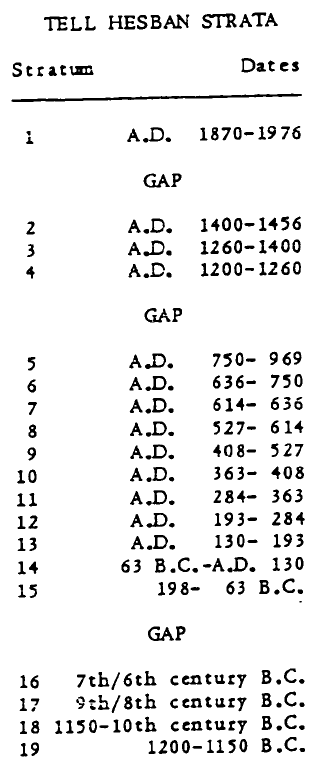 Table 1
Tell Hesban Strata
Click on image to open in a new tab
Storfjell (1983)
- from Storfjell (1993)
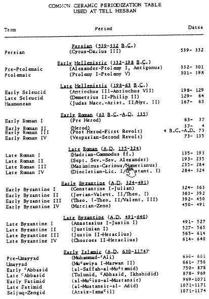
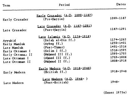 Table 2
Common Ceramic Periodization Table used at Tell Hesban
Click on image to open in a new tab
Storfjell (1983)
- Site Plan with excavation
areas from Stern et. al. (1993 v. 2)
Heshbon: map of the mound and excavation areas.
Stern et. al. (1993 v. 2) - Fig. 2 - Areas of excavations
at Tell Heshbon from Walker and LaBianca (2003)
Figure 2
Areas of excavations (Bert de Vries, Calvin College; Paul Ray, Jr., Andrews University; Ernest Cowles, Oklahoma State University; and Marvin Bowen, Andrews University).
Walker and LaBianca (2003)
- Table 7 from Mitchel (1980)
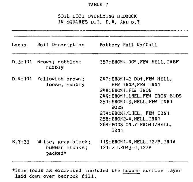
Table 7
Abbreviations
- DOM = Dominant
- TABF = Tabun Fragment
- BOD = Body Sherd
- IRN1 = Iron Age I
- IRN1A = Iron Age IA
- IRN2 = Iron Age II
- I2/P = Iron Age II/Persian
- HELL = Hellenistic
- LHEL = Late Hellenistic
- EROM = Early Roman
- Iron Age I - 1200-1000 BCE*
- Iron Age IA - 1200-1150 BCE*
- Iron Age II - 1000-586 BCE*
- Iron Age II/Persian - 1000*-332 BCE
- Hellenistic - 332-63 BCE
- Late Hellenistic - 198-63 BCE
- Early Roman I - 63-37 BCE
- Early Roman II - 37-4 BCE
- Early Roman III - 4 BCE-73 CE
- Early Roman IV - 73-135 CE
Mitchel (1980)
Though there are a number of loci which witness to the destruction of Stratum 14, the clearest probably being a sequence in the northeast corner of Square D.2 (loci D.2:79, D.2:78, D.2:70, D.2:59 [pl. 3.22]), the major evidence for the termination of this stratum resides in the massive bedrock collapse in Areas B and D (as has already been described). It is probable that a related set of factors makes this so. First, the bedrock in that specific sector of the site appears to have been softer (or at least to have had softer strata) and was thus naturally more subject to the natural production of karsts. This very softness would invite artificial (i.e., human) expansion of these underground caves and passages, which leads to the second factor. Not only would the bedrock be naturally less resistant to seismic shock, the resistance would be severely reduced by the very fact of its being honey-combed with chambers and passages. Alternatively, the resistance of the bedrock layers and/or the apparent reduced amount of underground building activity could explain the absence of collapsed Stratum 14 underground facilities and the continued use of these cave systems which survived in Areas A and C, for example the caves in Squares A.1 and C.7.
The earthquake which destroyed bedrock installations and closed out Stratum 14 occupation at Tell Hesban has been identified as possibly the earthquake of 31 B.C. (Sauer 1973a: 50; cf. Kallner-Amiran 1950, 1951). While this date is not impossible, given the evidence for destruction at Khirbet Qumran about 35 km east-southeast, the 31 B.C. earthquake was centered more in Galilee (Kallner-Amiran 1950: 225). In my judgment the observed destruction at the end of Stratum 14 at Tell Hesban seems more severe than that indicated for Khirbet Qumran in 31 B.C.
More troublesome to the 31 B.C. date, however, is the evidence of certain remains at the site. For one, a late coin was found in the fill of Silo D.3:57 (Object No. 1740, D.3:57C). The coin is of Aretas IV (9 B.C.–A.D. 40) and comes from the last (uppermost) layer of fill in the silo (subsidiary section drawing of balk 74:71a, fig. 3.8). This evidence by itself would suggest a date later than 31 B.C. for the destructive earthquake of Stratum 14 Stage A. (Though in fairness it must be admitted that the coins recovered at Tell Hesban have correlated poorly with associated pottery. More on this coin, and Tell Hesban coins in general, may be found in volume 12 of this series.) But the point must be argued further.
The filling of the silos, caves, and other broken-up bedrock installations at the end of the Early Roman period was apparently carried out nearly immediately after the earthquake occurred. This conclusion is based on the absence of evidence for extended exposure before filling (silt, water-laid deposits, etc.), which in fact suggests that maybe not even one winter’s rain can be accounted for between the earthquake and the Stratum 13 filling operation. If this conclusion is correct, then the Aretas IV coin had to have been introduced into the Silo D.3:57 fill soon after the earthquake. Consequently, this could not have been earlier than 9 B.C.
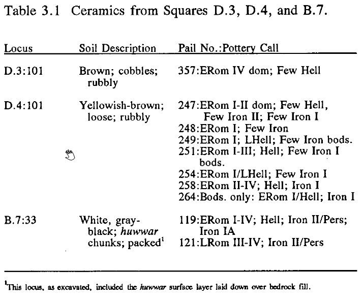 Table 3.1
Ceramics from Squares D.3, D.4, and B.7
Click on image to open in a new tab
Mitchel (1992)
Table 3.1 provides a systematic presentation of what I consider to be the critical ceramic evidence from loci in three adjacent squares: D.3, D.4, and B.7. The nature of the pottery preserved on the soft, deep fills overlying collapsed bedrock is also of significant importance to my argument in favor of the A.D. 130 earthquake as responsible for the final demise of underground (bedrock) installations in Areas B and D. The dates of the latest pottery uniformly carry us well beyond the date of the earthquake which damaged Khirbet Qumran, down, in fact, closer to the end of the first century A.D. or the beginning of the second century A.D.
In addition to these three fill loci, Soil Layer D.4:118A (pl. 3.23), inside collapsed Cave D.4:116 (+ D.4:118), yielded Early Roman I–III sherds, as well as two Late Roman I sherds (Square D.4 pottery pails 265, 266). Contamination of these latter samples is possible, but not likely. I dug the locus myself, and am reasonably sure of its provenance.
Obviously, this post-31 B.C. pottery could have been deposited much later than 31 B.C., closer, say, to the early second century A.D., but the evidence seems to be against such a view. I personally excavated much of locus D.4:101 (Stratum 13). It was a relatively homogeneous, unstratified fill of loose soil that gave all the appearances of rapid deposition in one operation. From field descriptions of the apparently parallel loci in Squares D.3 and B.7, I would judge them to be roughly equivalent and subject to the same interpretation and date. And I repeat, the evidence for extended exposure to the elements (and a concomitant slow, stratified deposition) was either missed in excavation, not properly recorded, or did not exist.
This case is surely not incontrovertible, but seems to me to carry the weight of the evidence which was excavated at Tell Hesban. Furthermore, the earthquake of A.D. 130, of those from this general time-period listed in Amiran’s earthquake catalogue, could better account for the massive destruction evidenced at Early Roman Tell Hesban, given the widespread evidence for this earthquake in Transjordan, from Jerash to Petra (Fritsch and Ben-Dor 1961: 55; Stinespring 1934: 15). In Gerasa (Jerash) an arch dedicated to Hadrian fell in the 192d year of the era of Gerasa (October 1, A.D. 129 to October 1, A.D. 130). The incised letters of the inscription on the north (inner) face had apparently been newly painted—perhaps newly finished—when the arch collapsed in an earthquake (Stinespring 1935: 4). It is possible this earthquake can be dated to the spring or summer of A.D. 130. Hadrian apparently made his trip in early summer of A.D. 130 (Weber 1936). Though there is yet some question about the precise date, at Petra there is evidence of a destructive earthquake probably to be dated in the early decades of the second century. Russell actually prefers a date of ca. A.D. 114 (Russell 1980b).
The building projects of Stratum 13 would have been begun soon after the earthquake damage had occurred, the first operation being the levelling out of broken-up bedrock surfaces.
Additional loci attributed to Stage A are: A.1:27; A.5:80; B.3:48; B.4:166, B.4:186, B.4:254, B.4:283E, B.4:283F; C.1:125; C.2:28, C.2:39. Loci which are assigned to Stratum 14, but do not materially contribute to a threefold understanding of the stratigraphy: A.2:46; A.3:51; A.8:38; B.2:106; B.3:56, B.3:57; B.4:152, B.4:204, B.4:221, B.4:233, B.4:255, B.4:263, B.4:283G; C.1:18, C.1:27, C.1:38, C.1:45, C.1:55, C.1:58, C.1:60, C.1:65, C.1:68, C.1:69, C.1:75, C.1:76–80, C.1:82, C.1:83, C.1:85–89, C.1:92, C.1:93, C.1:103–105, C.1:113, C.1:115, C.1:117; C.2:27, C.2:32, C.2:35, C.2:37, C.2:69–71; C.3:31; C.5:52, C.5:86, C.5:102, C.5:105, C.5:107, C.5:109, C.5:110, C.5:112, C.5:117, C.5:119, C.5:129, C.5:131, C.5:150, C.5:168, C.5:178, C.5:179, C.5:213, C.5:227; C.7:69, C.7:73, C.7:76, C.7:79, C.7:107; C.9:57, C.9:59; D.1:51, D.1:92; D.3:107; G.1:46.
- Site Plan with excavation
areas from Stern et. al. (1993 v. 2)
Heshbon: map of the mound and excavation areas.
Stern et. al. (1993 v. 2) - Fig. 2 - Areas of excavations
at Tell Heshbon from Walker and LaBianca (2003)
Figure 2
Areas of excavations (Bert de Vries, Calvin College; Paul Ray, Jr., Andrews University; Ernest Cowles, Oklahoma State University; and Marvin Bowen, Andrews University).
Walker and LaBianca (2003)
- Plate 25A - The Great Stairway
from Mitchel (1980)
Plate 25A
East Margin of Monumental Stairway, D.3. View East
Mitchel (1980)
- Site Plan with excavation
areas from Stern et. al. (1993 v. 2)
Heshbon: map of the mound and excavation areas.
Stern et. al. (1993 v. 2) - Fig. 2 - Areas of excavations
at Tell Heshbon from Walker and LaBianca (2003)
Figure 2
Areas of excavations (Bert de Vries, Calvin College; Paul Ray, Jr., Andrews University; Ernest Cowles, Oklahoma State University; and Marvin Bowen, Andrews University).
Walker and LaBianca (2003)
- Fig. 4 - Floor plan of Mamluk
and Umayyad buildings from Walker and LaBianca (2003)
Figure 4
Floor plan of Mamluk and Umayyad buildings, 2001 season (map by Ernest Cowles, Oklahoma State University). The bathhouse is the three-room structure occupying A08.
Walker and LaBianca (2003)
- Fig. 4 - Floor plan of Mamluk
and Umayyad buildings from Walker and LaBianca (2003)
Figure 4
Floor plan of Mamluk and Umayyad buildings, 2001 season (map by Ernest Cowles, Oklahoma State University). The bathhouse is the three-room structure occupying A08.
Walker and LaBianca (2003)
- Fig. 16 - Crushed Ceramic Vessels
from Walker and LaBianca (2003)
 Figure 16
Ceramic vessels crushed by fallen vault in Early Islamic Room N.1.
Walker and LaBianca (2003)
- Site Plan with excavation
areas from Stern et. al. (1993 v. 2)
Heshbon: map of the mound and excavation areas.
Stern et. al. (1993 v. 2) - Fig. 2 - Areas of excavations
at Tell Heshbon from Walker and LaBianca (2003)
Figure 2
Areas of excavations (Bert de Vries, Calvin College; Paul Ray, Jr., Andrews University; Ernest Cowles, Oklahoma State University; and Marvin Bowen, Andrews University).
Walker and LaBianca (2003) - Fig. 2 - Area Map from
Walker et al (2017)
Figure 2
Fields of excavation (courtesy of Qutaiba Dasouqi)
Walker et al (2017)
- Fig. 4 - Floor plan of Mamluk
and Umayyad buildings from Walker and LaBianca (2003)
Figure 4
Floor plan of Mamluk and Umayyad buildings, 2001 season (map by Ernest Cowles, Oklahoma State University). The bathhouse is the three-room structure occupying A08.
Walker and LaBianca (2003)
- Fig. 4 - Floor plan of Mamluk
and Umayyad buildings from Walker and LaBianca (2003)
Figure 4
Floor plan of Mamluk and Umayyad buildings, 2001 season (map by Ernest Cowles, Oklahoma State University). The bathhouse is the three-room structure occupying A08.
Walker and LaBianca (2003)
- Fig. 8 - Partially Collapsed Vault
from Walker and LaBianca (2003)
 Figure 8
Remains of partially collapsed barrel vault in L2.
Walker and LaBianca (2003)
| Effect | Location | Image | Description |
|---|---|---|---|
|
Bedrock Trench in Squares B.3 and D.4
Fig. 1.2 Plan of Tell Hesban with Excavation areas click on image to open in a new tab Ray (2001)
Fig. 5.10Stratum 20 Bedrock Trench (with Stratum 19 Wall and Stratum 18 House) click on image to open in a new tab Ray (2001) |
|
| Effect | Location | Image | Description |
|---|---|---|---|
| Tumble Layers |
Fig. 1.2 Plan of Tell Hesban with Excavation areas click on image to open in a new tab Ray (2001) |
Mitchel (1980:47) noted that there was limited evidence
for destruction and/or abandonment in Stratum 15 though most of the evidence was removed by subsequent building activities particularly in Stratum 13. Destruction layers were
variously described as debris, a rubble layer, or tumble. Due to slim evidence, Mitchel (1980:70) did not form firm conclusions about the nature of the end of Stratum 15 |
|
| Rebuilding |
Fig. 1.2 Plan of Tell Hesban with Excavation areas click on image to open in a new tab Ray (2001) |
Mitchel (1980:47) noted that there was limited evidence
for destruction and/or abandonment in Stratum 15 though most of the evidence was removed by subsequent building activities particularly in Stratum 13. Destruction layers were
variously described as debris, a rubble layer, or tumble. Due to slim evidence, Mitchel (1980:70) did not form firm conclusions about the nature of the end of Stratum 15 |
| Effect | Location | Image | Description |
|---|---|---|---|
| Collapsed Caves | from northern square D.3 into southern square B.4
Heshbon: map of the mound and excavation areas.
Stern et. al. (1993 v. 2)
Figure 2Areas of excavations (Bert de Vries, Calvin College; Paul Ray, Jr., Andrews University; Ernest Cowles, Oklahoma State University; and Marvin Bowen, Andrews University). Walker and LaBianca (2003)
Fig. 3.1Stratum 14 Significant Remains click on image to open in a new tab Mitchel (1992)
Fig. 1.2Plan of Tell Hesban with Excavation areas click on image to open in a new tab Ray (2001) |
Mitchel (1980:73) reports that,
over a wide area from northern square D.3 into southern square B.4, a majority of caves used for dwelling collapsed at the top of
Stratum 14 which could be noticed by:
bedrock surface channels, presumably for directing run-off water into storage facilities, which now are totally disrupted, and in many cases rest ten to twenty degrees from the horizontal; by caves with carefully cut steps leading down into them whose entrances are fully or largely collapsed and no longer usable; by passages from caves which can still be entered into formerly communicating caves which no longer exist, or are so low-ceilinged or clogged with debris as to make their use highly unlikely — at least as they stand now. |
|
| "jumble of broken-up bedrock" | Areas B and D had the best evidence for the massive bedrock collapse
Heshbon: map of the mound and excavation areas.
Stern et. al. (1993 v. 2)
Figure 2Areas of excavations (Bert de Vries, Calvin College; Paul Ray, Jr., Andrews University; Ernest Cowles, Oklahoma State University; and Marvin Bowen, Andrews University). Walker and LaBianca (2003) |
Abbreviations
Mitchel (1980) |
|
| Effect | Location | Image | Description |
|---|---|---|---|
| Collapsed Walls | retaining wall at the east margin of the stairs (D.3:16A)
Heshbon: map of the mound and excavation areas.
Stern et. al. (1993 v. 2)
Figure 2Areas of excavations (Bert de Vries, Calvin College; Paul Ray, Jr., Andrews University; Ernest Cowles, Oklahoma State University; and Marvin Bowen, Andrews University). Walker and LaBianca (2003)
Fig. 6.1Stratum 11 Significant Remains click on image to open in a new tab Mitchel (1992)
Fig. 1.2Plan of Tell Hesban with Excavation areas click on image to open in a new tab Ray (2001)
Fig. 6.3Stratum 11 Features in Area D click on image to open in a new tab Mitchel (1992) |
Fig. 6.4 Square D.3, South Balk click on image to open in a new tab Mitchel (1992)
Fig. 6.5Square D.4, North Balk click on image to open in a new tab Mitchel (1992)
Plate 6.13Square D.3, South Balk, West Section A.I. Enhanced click on image to open in a new tab Mitchel (1992)
Plate 6.14Square D.4, North Balk A.I. Enhanced click on image to open in a new tab Mitchel (1992)
Plate 6.15Huwwar Layers South of Stairway A.I. Enhanced click on image to open in a new tab Mitchel (1992)
Plate 25AEast Margin of Monumental Stairway, D.3. View East A.I. Enhanced click on image to open in a new tab Mitchel (1980) |
|
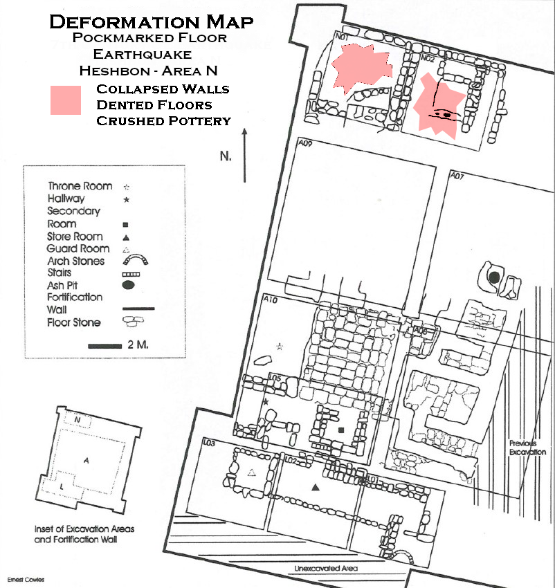
| Effect | Location | Image | Description |
|---|---|---|---|
| Crushed Jars and dented floor due to collapsed walls | rooms (N.1:18, N.2:16)
Figure 4 Floor plan of Mamluk and Umayyad buildings, 2001 season (map by Ernest Cowles, Oklahoma State University). The bathhouse is the three-room structure occupying A08. Walker and LaBianca (2003) 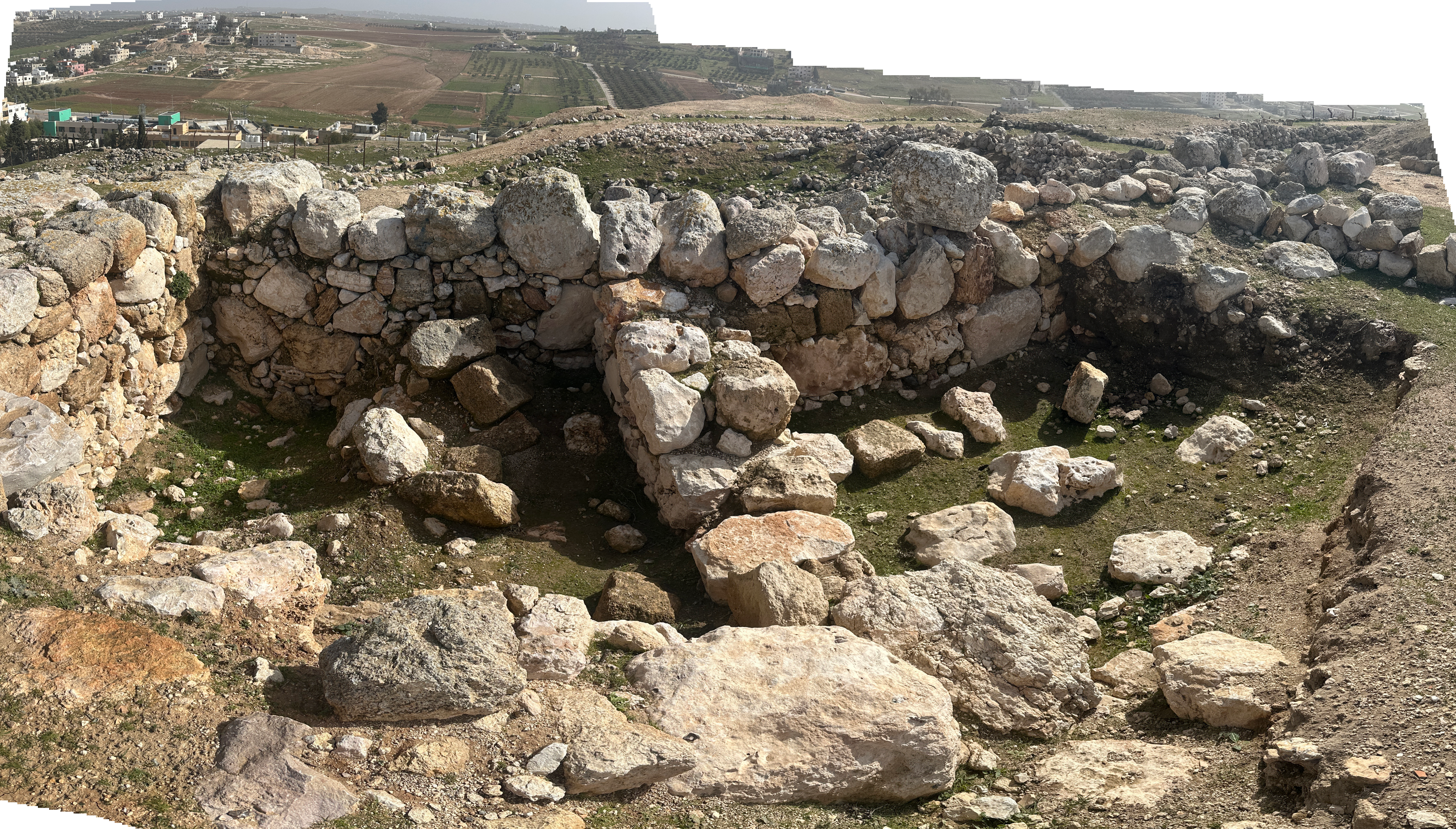 Rooms N.1 and N.2 (?)
Click on image to open in a new tab Photo by Jefferson Williams - 27 Jan. 2026 |
Figure 16 Ceramic vessels crushed by fallen vault in Early Islamic Room N.1. Walker and LaBianca (2003)
Fig. 1.2Plan of Tell Hesban with Excavation areas click on image to open in a new tab Ray (2001) |
|
| Collapsed walls and fire |
Figure 4 Floor plan of Mamluk and Umayyad buildings, 2001 season (map by Ernest Cowles, Oklahoma State University). The bathhouse is the three-room structure occupying A08. Walker and LaBianca (2003) |
|
| Effect | Location | Image | Description |
|---|---|---|---|
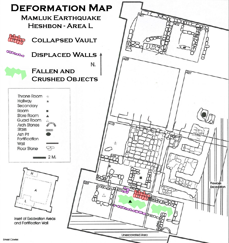
| Displaced walls | L.2 part of the storeroom
Figure 4 Floor plan of Mamluk and Umayyad buildings, 2001 season (map by Ernest Cowles, Oklahoma State University). The bathhouse is the three-room structure occupying A08. Walker and LaBianca (2003) |
|
|
| Collapsed vaults | L.2 part of the storeroom
Figure 4 Floor plan of Mamluk and Umayyad buildings, 2001 season (map by Ernest Cowles, Oklahoma State University). The bathhouse is the three-room structure occupying A08. Walker and LaBianca (2003) |
Figure 8 Remains of partially collapsed barrel vault in L2. Walker and LaBianca (2003) |
|
| Fallen and crushed objects | L.1:17 - L.2:12, the beaten earth floor of the Mamluk-period (Stratum IVb) storeroom
Figure 4 Floor plan of Mamluk and Umayyad buildings, 2001 season (map by Ernest Cowles, Oklahoma State University). The bathhouse is the three-room structure occupying A08. Walker and LaBianca (2003) |
|
|
| Fire | L.2 part of the storeroom
Figure 4 Floor plan of Mamluk and Umayyad buildings, 2001 season (map by Ernest Cowles, Oklahoma State University). The bathhouse is the three-room structure occupying A08. Walker and LaBianca (2003) |
|
|
| Collapsed walls | Field M - M4, M5, M8, and M9
Figure 2 Fields of excavation (courtesy of Qutaiba Dasouqi) Walker et al (2017) |
|
|
| Collapsed vaults | Field M - M4, M5, M8, and M9
Figure 2 Fields of excavation (courtesy of Qutaiba Dasouqi) Walker et al (2017) |
|
|
| Displaced Masonry blocks | Field M - M4, M5, M8, and M9
Figure 2 Fields of excavation (courtesy of Qutaiba Dasouqi) Walker et al (2017) |
|
- Modified by JW from Fig. 1.2 of Ray (2001)
 Deformation Map
Modified by JW from Fig. 1.2 of Ray (2001)
click on image to open in a new tab
- Modified by JW from Fig. 6.3 of Mitchel (1992)
 Deformation Map
Modified by JW from Fig. 6.3 of Mitchel (1992)
click on image to open in a new tab
- Modified by JW from Fig. 4 of Walker and LaBianca (2003)
 Deformation Map
Modified by JW from Fig. 4 of Walker and LaBianca (2003)
click on image to open in a new tab
- Modified by JW from Fig. 4 of Walker and LaBianca (2003)
 Deformation Map
Modified by JW from Fig. 4 of Walker and LaBianca (2003)
- Earthquake Archeological Effects chart
of Rodríguez-Pascua et al (2013: 221-224)
 Earthquake Archeological Effects (EAE)
Rodríguez-Pascua et al (2013: 221-224)
| Effect | Location | Image | Description | Intensity |
|---|---|---|---|---|
|
Bedrock Trench in Squares B.3 and D.4
Fig. 1.2 Plan of Tell Hesban with Excavation areas click on image to open in a new tab Ray (2001)
Fig. 5.10Stratum 20 Bedrock Trench (with Stratum 19 Wall and Stratum 18 House) click on image to open in a new tab Ray (2001) |
|
|
-
Earthquake Archeological Effects chart
of Rodríguez-Pascua et al (2013: 221-224)
Earthquake Archeological Effects (EAE)
Rodríguez-Pascua et al (2013: 221-224)
| Effect | Location | Image | Description | Intensity |
|---|---|---|---|---|
| Tumble Layers may suggest collapsed walls |
Fig. 1.2 Plan of Tell Hesban with Excavation areas click on image to open in a new tab Ray (2001) |
Mitchel (1980:47) noted that there was limited evidence
for destruction and/or abandonment in Stratum 15 though most of the evidence was removed by subsequent building activities particularly in Stratum 13. Destruction layers were
variously described as debris, a rubble layer, or tumble. Due to slim evidence, Mitchel (1980:70) did not form firm conclusions about the nature of the end of Stratum 15 |
VIII + | |
| Rebuilding may suggest collapsed walls |
Fig. 1.2 Plan of Tell Hesban with Excavation areas click on image to open in a new tab Ray (2001) |
Mitchel (1980:47) noted that there was limited evidence
for destruction and/or abandonment in Stratum 15 though most of the evidence was removed by subsequent building activities particularly in Stratum 13. Destruction layers were
variously described as debris, a rubble layer, or tumble. Due to slim evidence, Mitchel (1980:70) did not form firm conclusions about the nature of the end of Stratum 15 |
VIII + |
-
Earthquake Archeological Effects chart
of Rodríguez-Pascua et al (2013: 221-224)
Earthquake Archeological Effects (EAE)
Rodríguez-Pascua et al (2013: 221-224)
| Effect | Location | Image | Description | Intensity |
|---|---|---|---|---|
| Collapsed Caves | from northern square D.3 into southern square B.4
Heshbon: map of the mound and excavation areas.
Stern et. al. (1993 v. 2)
Figure 2Areas of excavations (Bert de Vries, Calvin College; Paul Ray, Jr., Andrews University; Ernest Cowles, Oklahoma State University; and Marvin Bowen, Andrews University). Walker and LaBianca (2003)
Fig. 3.1Stratum 14 Significant Remains click on image to open in a new tab Mitchel (1992)
Fig. 1.2Plan of Tell Hesban with Excavation areas click on image to open in a new tab Ray (2001) |
Mitchel (1980:73) reports that,
over a wide area from northern square D.3 into southern square B.4, a majority of caves used for dwelling collapsed at the top of
Stratum 14 which could be noticed by:
bedrock surface channels, presumably for directing run-off water into storage facilities, which now are totally disrupted, and in many cases rest ten to twenty degrees from the horizontal; by caves with carefully cut steps leading down into them whose entrances are fully or largely collapsed and no longer usable; by passages from caves which can still be entered into formerly communicating caves which no longer exist, or are so low-ceilinged or clogged with debris as to make their use highly unlikely — at least as they stand now. |
III + | |
| "jumble of broken-up bedrock" may suggest collapsed walls | Areas B and D had the best evidence for the massive bedrock collapse
Heshbon: map of the mound and excavation areas.
Stern et. al. (1993 v. 2)
Figure 2Areas of excavations (Bert de Vries, Calvin College; Paul Ray, Jr., Andrews University; Ernest Cowles, Oklahoma State University; and Marvin Bowen, Andrews University). Walker and LaBianca (2003) |
Abbreviations
Mitchel (1980) |
|
VIII + |
- Earthquake Archeological Effects chart
of Rodríguez-Pascua et al (2013: 221-224)
Earthquake Archeological Effects (EAE)
Rodríguez-Pascua et al (2013: 221-224)
| Effect | Location | Image | Description | Intensity |
|---|---|---|---|---|
| Collapsed Walls | retaining wall at the east margin of the stairs (D.3:16A)
Heshbon: map of the mound and excavation areas.
Stern et. al. (1993 v. 2)
Figure 2Areas of excavations (Bert de Vries, Calvin College; Paul Ray, Jr., Andrews University; Ernest Cowles, Oklahoma State University; and Marvin Bowen, Andrews University). Walker and LaBianca (2003)
Fig. 6.1Stratum 11 Significant Remains click on image to open in a new tab Mitchel (1992)
Fig. 1.2Plan of Tell Hesban with Excavation areas click on image to open in a new tab Ray (2001)
Fig. 6.3Stratum 11 Features in Area D click on image to open in a new tab Mitchel (1992) |
Fig. 6.4 Square D.3, South Balk click on image to open in a new tab Mitchel (1992)
Fig. 6.5Square D.4, North Balk click on image to open in a new tab Mitchel (1992)
Plate 6.13Square D.3, South Balk, West Section A.I. Enhanced click on image to open in a new tab Mitchel (1992)
Plate 6.14Square D.4, North Balk A.I. Enhanced click on image to open in a new tab Mitchel (1992)
Plate 6.15Huwwar Layers South of Stairway A.I. Enhanced click on image to open in a new tab Mitchel (1992)
Plate 25AEast Margin of Monumental Stairway, D.3. View East A.I. Enhanced click on image to open in a new tab Mitchel (1980) |
|
VIII + |
-
Earthquake Archeological Effects chart
of Rodríguez-Pascua et al (2013: 221-224)
Earthquake Archeological Effects (EAE)
Rodríguez-Pascua et al (2013: 221-224)
| Effect | Location | Image | Description | Intensity |
|---|---|---|---|---|
| Crushed Jars and dented floor due to collapsed walls | rooms (N.1:18, N.2:16)
Figure 4 Floor plan of Mamluk and Umayyad buildings, 2001 season (map by Ernest Cowles, Oklahoma State University). The bathhouse is the three-room structure occupying A08. Walker and LaBianca (2003)
Rooms N.1 and N.2 (?)
Click on image to open in a new tab Photo by Jefferson Williams - 27 Jan. 2026 |
Figure 16 Ceramic vessels crushed by fallen vault in Early Islamic Room N.1. Walker and LaBianca (2003)
Fig. 1.2Plan of Tell Hesban with Excavation areas click on image to open in a new tab Ray (2001) |
|
VII + |
| Collapsed walls and fire |
Figure 4 Floor plan of Mamluk and Umayyad buildings, 2001 season (map by Ernest Cowles, Oklahoma State University). The bathhouse is the three-room structure occupying A08. Walker and LaBianca (2003) |
|
VIII + |
-
Earthquake Archeological Effects chart
of Rodríguez-Pascua et al (2013: 221-224)
Earthquake Archeological Effects (EAE)
Rodríguez-Pascua et al (2013: 221-224)
| Effect | Location | Image | Description | Intensity |
|---|---|---|---|---|
| Displaced walls | L.2 part of the storeroom
Figure 4 Floor plan of Mamluk and Umayyad buildings, 2001 season (map by Ernest Cowles, Oklahoma State University). The bathhouse is the three-room structure occupying A08. Walker and LaBianca (2003) |
|
VII + | |
| Collapsed vaults | L.2 part of the storeroom
Figure 4 Floor plan of Mamluk and Umayyad buildings, 2001 season (map by Ernest Cowles, Oklahoma State University). The bathhouse is the three-room structure occupying A08. Walker and LaBianca (2003) |
Figure 8 Remains of partially collapsed barrel vault in L2. Walker and LaBianca (2003) |
|
VIII + |
| Fallen and crushed objects | L.1:17 - L.2:12, the beaten earth floor of the Mamluk-period (Stratum IVb) storeroom
Figure 4 Floor plan of Mamluk and Umayyad buildings, 2001 season (map by Ernest Cowles, Oklahoma State University). The bathhouse is the three-room structure occupying A08. Walker and LaBianca (2003) |
|
VII + | |
| Collapsed walls | Field M - M4, M5, M8, and M9
Figure 2 Fields of excavation (courtesy of Qutaiba Dasouqi) Walker et al (2017) |
|
VIII + | |
| Collapsed vaults | Field M - M4, M5, M8, and M9
Figure 2 Fields of excavation (courtesy of Qutaiba Dasouqi) Walker et al (2017) |
|
VIII + | |
| Displaced Masonry blocks | Field M - M4, M5, M8, and M9
Figure 2 Fields of excavation (courtesy of Qutaiba Dasouqi) Walker et al (2017) |
|
VIII + |
- Most of the publications on Heshbon appear in Andrews University Seminary Studies.