Mamshit/Mampsis
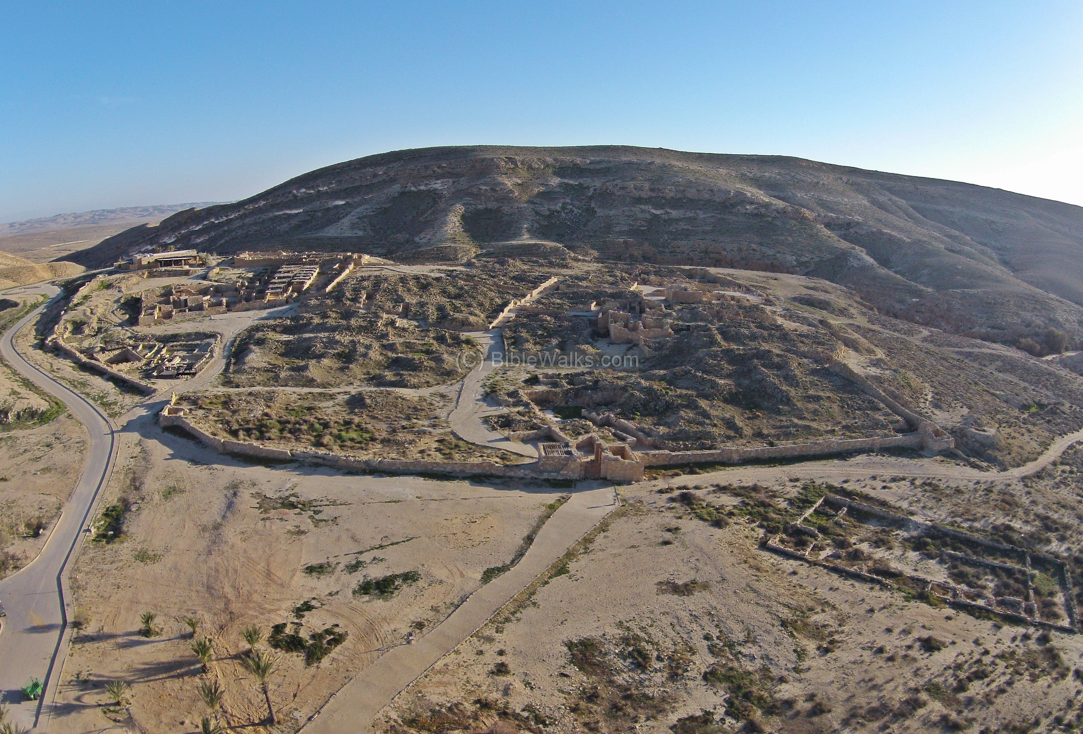 Aerial View of Mamshit
Click on Image to open a high resolution magnifiable image in a new tab
Biblewalks.com
| Transliterated Name | Source | Name |
|---|---|---|
| Mamshit | Hebrew | ממשית |
| Kurnub | Modern Arabic | كورنوب |
| Kurnub | Nabatean ? | |
| Kurnub | Arabic | |
| Mampsis | Byzantine Greek | Μαμψις |
| Memphis | Ancient Greek | Μέμφις |
- Incense Road Map with Mamshit
from BibleWalks.com
- Fig. 1.6 - Towns and Forts
in the Central Negev and Arava Valley during Early Roman through Byzantine periods from Erickson-Gini (2010)
 Figure 1.6
Towns and Forts in the Central Negev and Arava Valley. Early Roman through Byzantine periods.
Erickson-Gini (2010)

- Incense Road Map with Mamshit
from BibleWalks.com
- Fig. 1.6 - Towns and Forts
in the Central Negev and Arava Valley during Early Roman through Byzantine periods from Erickson-Gini (2010)
Figure 1.6
Towns and Forts in the Central Negev and Arava Valley. Early Roman through Byzantine periods.
Erickson-Gini (2010)
- Fig. 8 - Aerial View of Mampsis
from Sion and Israeli (2022)
 Figure 8
Mampsis, looking west (photo G. Fitoussi).
Sion and Israeli (2022) - Fig. 7 - Aerial photo of
the eastern hill - from Sion and Israeli (2022)
 Figure 7
The eastern hill, looking northeast (photo G. Fitoussi).
Sion and Israeli (2022) - Fig. 10 - Aerial photo
of Commander residency - from Sion and Israeli (2022)
 Figure 10
Commander residency (photo G. Fitoussi).
Sion and Israeli (2022) - Fig. 14 - Aerial photo
of Western Church Compound - from Sion and Israeli (2022)
 Figure 14
Western church compound, looking north (photo G. Fitoussi).
Sion and Israeli (2022) - Mamshit in Google Earth
 Mamshit in Google Earth
click on image to explore this site on a new tab in Google Earth - Mamshit on govmap.gov.il
 Mamshit on govmap.gov.il
click on image to explore this site on a new tab in govmap.gov.il
- Plan of Mamshit from
Stern et. al. (1993 v.3)
 Kurnub [aka Mamshit]: plan of the town.
- Building I, palace
- Building II, tower
- Western Church
- Building XV
- Building V, bathhouse
- Building VII, pool
- Building XII
- Eastern Church
- Main gate
- Water gate
- Building VIII, caravanserai
Stern et. al. (1993 v.3) - Fig. 2a - City plan from
Korzhenkov and Mazor (2003)
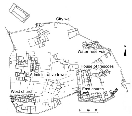 Figure 2a
City plan of ancient Mamshit
Korjenkov and Mazor (2003) - Fig. 5 - City Plan from
Sion and Israeli (2022)
 Figure 5
City plan (O. Sion, S. Israeli and D. Porotsky).
Sion and Israeli (2022) - Fig. 6 - Plan of Mampsis
by period - from Sion and Israeli (2022)
 Figure 6
Insulae and Structures according to periods (O. Sion, S. Israeli and D. Porotsky).
Sion and Israeli (2022) - Site plan of Mamshit
from BibleWalks.com
- Plan 1 - Site plan of
Mamshit from Negev (1988b)
 Plan 1
General plan of Mampsis
Negev (1988b)

- Plan of Mamshit from
Stern et. al. (1993 v.3)
Kurnub [aka Mamshit]: plan of the town.
- Building I, palace
- Building II, tower
- Western Church
- Building XV
- Building V, bathhouse
- Building VII, pool
- Building XII
- Eastern Church
- Main gate
- Water gate
- Building VIII, caravanserai
Stern et. al. (1993 v.3) - Fig. 2a - City plan from
Korzhenkov and Mazor (2003)
Figure 2a
City plan of ancient Mamshit
Korjenkov and Mazor (2003) - Fig. 5 - City Plan from
Sion and Israeli (2022)
Figure 5
City plan (O. Sion, S. Israeli and D. Porotsky).
Sion and Israeli (2022) - Fig. 6 - Plan of Mampsis
by period - from Sion and Israeli (2022)
Figure 6
Insulae and Structures according to periods (O. Sion, S. Israeli and D. Porotsky).
Sion and Israeli (2022) - Site plan of Mamshit
from BibleWalks.com
- Plan 1 - Site plan of
Mamshit from Negev (1988b)
Plan 1
General plan of Mampsis
Negev (1988b)
- Fig. 9 - Plan of army camp
from Sion and Israeli (2022)
 Figure 9
Plan of army camp and commander residency (O. Sion and D. Porotsky).
Sion and Israeli (2022)
- Fig. 9 - Plan of army camp
from Sion and Israeli (2022)
Figure 9
Plan of army camp and commander residency (O. Sion and D. Porotsky).
Sion and Israeli (2022)
- Fig. 1.64 Plan and
Aerial View of Building XXV from Erickson-Gini (2010)
 Figure 1.64
Mampsis, Building XXV, plan and photo to east
Sion and Israeli (2022)
- Fig. 1.64 Plan and
Aerial View of Building XXV from Erickson-Gini (2010)
Figure 1.64
Mampsis, Building XXV, plan and photo to east
Sion and Israeli (2022)
- Fig. 1.68 Plan of Building XII
South from Erickson-Gini (2010)
 Figure 1.68
Mampsis, Area Building XII South
Sion and Israeli (2022)
- Fig. 1.68 Plan of Building XII
South from Erickson-Gini (2010)
Figure 1.68
Mampsis, Area Building XII South
Sion and Israeli (2022)
- Image courtesy of www.HolyLandPhotos.org
 Mamshit in the Byzantine Period
Image courtesy of www.HolyLandPhotos.org
- Fig. 1.65 Building XXV section
from Erickson-Gini (2010)
 Figure 1.65
Mampsis, Building XXV section
Sion and Israeli (2022)
- Fig. 1.65 Building XXV section
from Erickson-Gini (2010)
Figure 1.65
Mampsis, Building XXV section
Sion and Israeli (2022)
- Fig. 1.69 Building XII South
Section from Erickson-Gini (2010)
 Figure 1.69
Section drawing and debris layers in Area Building XII South, Mampsis
Sion and Israeli (2022)
- Fig. 1.69 Building XII South
Section from Erickson-Gini (2010)
Figure 1.69
Section drawing and debris layers in Area Building XII South, Mampsis
Sion and Israeli (2022)
- Fig. 1.66a In situ unguentarium
in Phase 2 from Erickson-Gini (2010)
 Figure 1.66a
In situ unguentarium in Phase 2
Sion and Israeli (2022) - Fig. 1.66b in situ braziers
found in Phase 3, 363 CE from Building XXV from Erickson-Gini (2010)
 Figure 1.66b
in situ braziers made of inverted “Gaza” wine jars found in Phase 3, 363 CE from Building XXV, Mampsis
Sion and Israeli (2022) - Fig. 1.67 Finds from the
kitchen in Phase 3 of Building XXV destroyed in the 363 CE earthquake from Erickson-Gini (2010)
 Figure 1.67
Finds from the kitchen in Phase 3 of Building XXV destroyed in the 363 CE earthquake at Mampsis
Sion and Israeli (2022)


- from Schmid (1995)
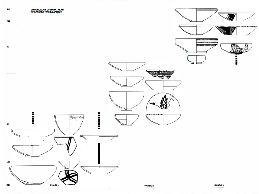
Left
Chronology of Nabatean finewares
Right
Typology and chronology of the Nabataean fine ware
Both from Schmid (1995)
- from Dolinka (2006) citing Schmid (2000)
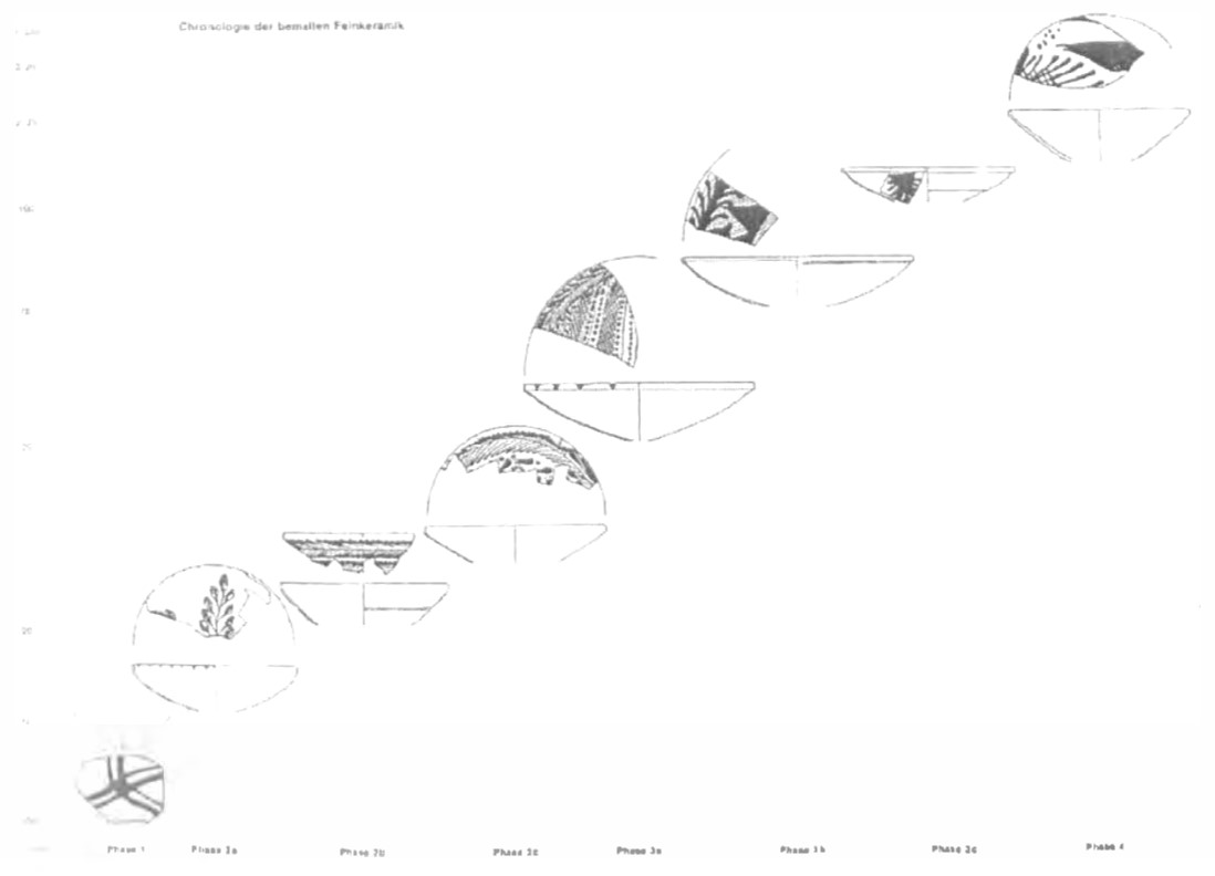 Figure 1.3
Typo-chronology for the NPFW bowls developed by Schmid (2000: abb. 98)
Dolinka (2006)
Figure 6Insulae and Structures according to periods (O. Sion, S. Israeli and D. Porotsky).
Sion and Israeli (2022)
- from Lower parts of buildings (built in Nabatean and Roman Periods)
| Effect | Location | Image(s) | Description |
|---|---|---|---|
| Systematic Tilting of Walls | E of West Church Figure 2b
The West Church and Administrative Tower Quarters Roman numbers denote residential quarters Arabic numbers the location of Figures Korjenkov and Mazor (2003) Entire Site |
3a
 Figure 3a
Tilted walls. South side of the north wall of a room east of the west Church, the wall has a trend of 86° and the average inclination is 79°. Korjenkov and Mazor (2003) 3b  Figure 3b
Tilted walls. North side of the same wall, the lower stone rows are tilted northward by up to 60° Korjenkov and Mazor (2003) 3c  Figure 3c
Tilted walls. Summary of measurements: direction of tilting patterns observed at the lower parts of walls at Mamshit (Tab. 1), as a function of the direction of the walls, revealing that out of 30 cases of walls trending ENE (55° to 105°), 26 were found to be tilted northward, 180 and only 4 cases are tilted southward, whereas the perpendicular walls (trending 145° to 185°) show only 9 tilting cases with no preferred direction Korjenkov and Mazor (2003) 3d  Figure 3d
Tilted walls. Stress directions concluded from the observed tilting patterns Korjenkov and Mazor (2003) |
Observed damage pattern: tilted walls or wall segments (Figs. 3 a. b). By convention, the direction of tilting is defined by the direction pointed by the upper part of the tilted segment. Only cases of tilting of most of the wall were included in this study.- Korzhenkov and Mazor (2003) |
| Lateral Shifting of Building Elements | E of West Church
Figure 2b The West Church and Administrative Tower Quarters Roman numbers denote residential quarters Arabic numbers the location of Figures Korjenkov and Mazor (2003) |
4
 Figure 4
Lower stone of a N-S trending (175°) arch, shifted 8cm northward (the original position is marked by dashed lines). This is the fourth arch of the eastern line of fodder-basins of the Stables. The lowest stone of the arch has been severely cracked during the seismically caused shifting Korjenkov and Mazor (2003) |
Observed damage pattern: northward shifting by 8 cm, as well as severe cracking of the lowest stone in a 175° trending arch (Fig.4). Thus, a large building element was shifted, and in addition slightly rotated clockwise. The location is at the eastern line of fodder-basins of a complex of stables, at a residential quarter east of the West Church.- Korzhenkov and Mazor (2003) |
| Rotation of Wall Fragments around a Vertical Axis | ENE of West Church
Figure 2b The West Church and Administrative Tower Quarters Roman numbers denote residential quarters Arabic numbers the location of Figures Korjenkov and Mazor (2003) Near Frescoes House  Figure 2c
East Church and House of Frescoes Quarters Roman numbers denote residential quarters Arabic numbers the location of Figures Korjenkov and Mazor (2003) Entire Site |
5a
 Figure 5a
Rotation patterns at walls of the Roman period. Clockwise rotation of stones of the lowest row of a 172° trending wall of a room ENE of the West Church; stone A was rotated by 5° and stone B by 10°, the horizontal displacement of the two stones being 21.5cm. Korjenkov and Mazor (2003) 5b 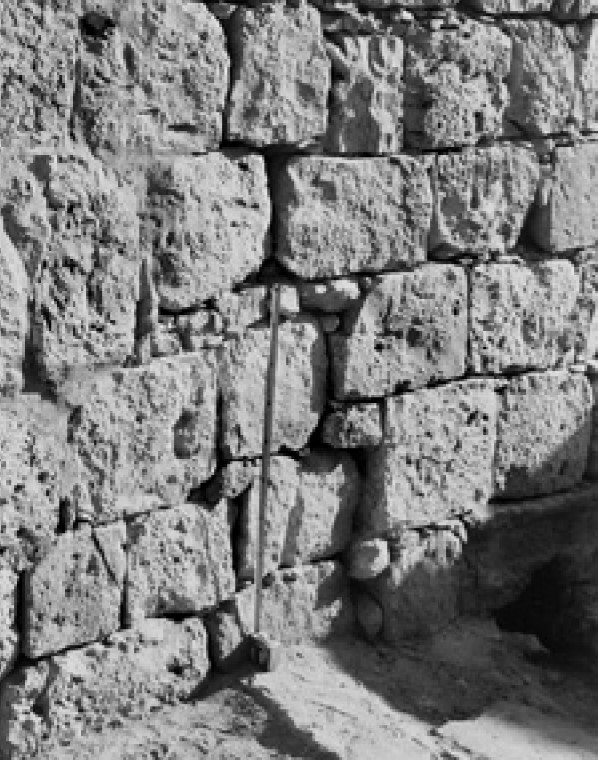 Figure 5b
Rotation patterns at walls of the Roman period. A 2° counterclockwise rotation of stones in the lower part of a 59° trending wall at a yard near the Frescoes House. Korjenkov and Mazor (2003) 5c  Figure 5c
Rotation patterns at walls of the Roman period. Angle of rotation as a function of wall trends: SES (150°-185°) trending walls reveal mainly clockwise rotation, whereas walls trending NEN (60°-95°) reveal mainly counterclockwise rotations Korjenkov and Mazor (2003) 5d  Figure 5d
Rotation patterns at walls of the Roman period. Stress directions concluded from the observed rotation patterns Korjenkov and Mazor (2003) |
Observed damage pattern: 1. An example of clockwise rotation of stones within a wall trending 172°, in a room located ENE of the West Church (Fig. 5 a). Stone A was rotated 5° clockwise and stone B was rotated 10° clockwise, the horizontal displacement between these rotated stones being 21.5 cm.. An example of a counterclockwise rotation in the northern wall of the Frescoes House (Fig. 5 b); the trend of the wall was 59° and the azimuth of the rotated wall fragment is 57°.- Korzhenkov and Mazor (2003) |
| Cracking of Door Steps, Staircases and Lintels | Administrative Tower
Figure 2b The West Church and Administrative Tower Quarters Roman numbers denote residential quarters Arabic numbers the location of Figures Korjenkov and Mazor (2003) E of West Church
Figure 2bThe West Church and Administrative Tower Quarters Roman numbers denote residential quarters Arabic numbers the location of Figures Korjenkov and Mazor (2003) Entire Site |
6a
 Figure 6a
Cracks in the southern (left) edge of a doorstep and the southern doorpost, at an entrance trending N-S (175°), leading to a room west of the Administrative Tower. Korjenkov and Mazor (2003) 6b  Figure 6b
A similar set of cracks in the entrance to a room east of the Administrative Tower. Korjenkov and Mazor (2003) 6c  Figure 6c
Stress directions concluded from the observed cracked patterns, disclosing movement of the adjacent walls Korjenkov and Mazor (2003) 7a  Figure 7a
Open cracks at the bottom and closed cracks at the top of a E-W (83°) trending staircase inside a Late Nabatean Building, and tilted side walls Korjenkov and Mazor (2003) 7b  Figure 7b
Stress directions concluded from the observed open and closed crack patterns, disclosing northward movement of southern walls. Thus the seismic push arrived from north Korjenkov and Mazor (2003) 8  Figure 8
Number of cracks observed in doorsteps, staircases and lintels as a function of the direction of the latter. The number of observations in N-S structures is three times greater than the observations in the perpendicular walls, leading to the conclusion that the seismic shock arrived from north Korjenkov and Mazor (2003) |
Observed damage pattern: A 175° trending doorstep of the entrance into one of the rooms of the Administrative Tower was cracked at its southern part (Fig. 6 a) and a similar damage pattern is seen in the doorstep of another room, located eastward within the same building (Fig. 6 b).- Korzhenkov and Mazor (2003) |
| Slipped Keystones of Arches | W of Eastern Church
Figure 2c East Church and House of Frescoes Quarters Roman numbers denote residential quarters Arabic numbers the location of Figures Korjenkov and Mazor (2003) Stables - E of West Church
Figure 2bThe West Church and Administrative Tower Quarters Roman numbers denote residential quarters Arabic numbers the location of Figures Korjenkov and Mazor (2003) |
9a
 Figure 9a
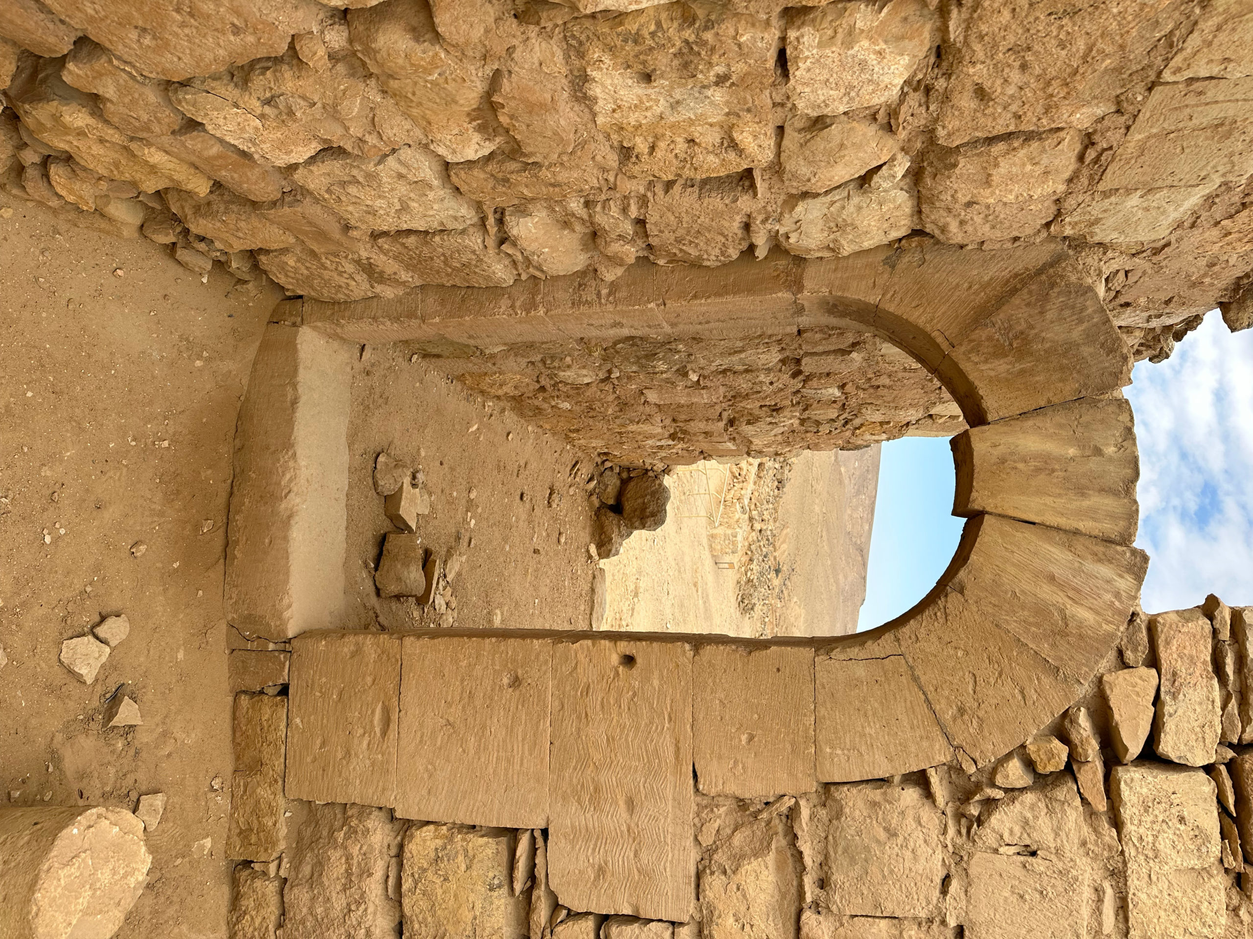
Keystone, slipped down 6cm in a N-S (174°) trending arch in a room west of the Eastern Church Korjenkov and Mazor (2003)  Dropped Keystone of Mamshit
Rear View Long Shot Photo by Jefferson Williams 12 Jan. 2023 9b  Figure 9b
Two central stones, slipped 3cm down in an N-S (175°) trending arch above the third fodder-basin in the Stables Korjenkov and Mazor (2003) 9c  Figure 9c
Diagram of the operating stresses, leading to the conclusion that the seismic wave propagation was approximately parallel to the damaged arches, i.e. along a N-S direction Korjenkov and Mazor (2003) |
Observed damage pattern: A 174° trending arch, located in a room west of the Eastern Church, exhibits a keystone that slipped 6cm down of its original position, as can be seen in Fig. 9 a. A pair of keystones slipped 3cm down in a 175° trending arch located above the third fodder-basin in the Stables (Fig. 9 b). An important auxiliary observation is that in these cases the arches themselves were not deformed.- Korzhenkov and Mazor (2003) |
| Jointing | Administrative Tower
Figure 2b The West Church and Administrative Tower Quarters Roman numbers denote residential quarters Arabic numbers the location of Figures Korjenkov and Mazor (2003) |
10a
 Figure 10a
Examples of jointing A 88cm joint crossing two adjacent stones in the West wall (175° trending) of the Administrative Tower Korjenkov and Mazor (2003) 10b  Figure 10b
Examples of jointing A 70cm joint crossing the lower part of a 178° trending arch support in a courtyard west of the Administrative Tower. Such joints are indication of a strong earthquake, around VII–VIII in the EMS-98 scale Korjenkov and Mazor (2003) |
Observed damage pattern: At the western wall of the Administrative Tower, trending 178°, an 88cm long joint is seen crossing two stones (Fig.10 a). A 70cm long joint is seen at the lower support stone of a 178° trending arch, located in a room west of the Administrative Tower (Fig.10 b).- Korzhenkov and Mazor (2003) |
| Pushing of Walls by Connected Perpendicular Walls | Entire site | 11
 Figure 11
Both, clockwise and counterclock-wise rotations of adjacent stones in a wall, caused by a strong seismic push of a connected perpendicular wall Korjenkov and Mazor (2003) |
Observed damage pattern: Clockwise and counterclockwise rotations of adjacent stones in a wall, caused by a push of a connected perpendicular wall (Fig. 11).- Korzhenkov and Mazor (2003) |
| Percentage of Heavily Damaged Buildings | Entire site | The destroyed Roman buildings were rebuilt and, thus, many of the destroyed building parts were cleared away. The large number of deformation patterns that seen in the remaining parts of the Roman period buildings makes room to the assessment that practically all houses were damaged. Thus, the intensity of the tremor was IX EMS-98 scale or more.- Korzhenkov and Mazor (2003) |
|
|
Building XXV
Figure 1.64 Mampsis, Building XXV, plan and photo to east Sion and Israeli (2022) |
Figure 1.66b in situ braziers made of inverted “Gaza” wine jars found in Phase 3, 363 CE from Building XXV, Mampsis Sion and Israeli (2022)
Figure 1.67Finds from the kitchen in Phase 3 of Building XXV destroyed in the 363 CE earthquake at Mampsis Sion and Israeli (2022) |
JW: Building XXV was said to have been particularly hard hit. This building, according to
Erickson-Gini (2010:129), sustained such heavy damage that it was abandoned and never rebuilt. Room 2, apparently used as a kitchen, preserved a rich lode of pottery sealed and found in situ on the floor of the collapsed room. Some of the pottery was interpreted as having fallen from shelves in the "kitchen". Erickson-Gini (2010:80) reports that in situ coins were found in the earthquake debris in Building XXV. Erickson-Gini (2010:129) reports that the walls of adjacent Rooms 1 and 2 ("kitchen") of Building XXV were rather insubstantial additions to the original structurewhich were constructed in a shallow layer of soilwhich appears to have contributed to the collapse of the kitchen. |
- from Upper parts of buildings (repaired and built in the Byzantine Period)
| Effect | Location | Image(s) | Description |
|---|---|---|---|
| Tilting of Walls | S of West Church
Figure 2b The West Church and Administrative Tower Quarters Roman numbers denote residential quarters Arabic numbers the location of Figures Korjenkov and Mazor (2003) Entire Site |
12a
 Figure 12a
Upper stones tilted 75° westward at a N-S (176°) trending wall, located at the west in a room south of the West Church Korjenkov and Mazor (2003) 12b  Figure 12b
Tilting westward of upper stones of the N-S (174°) trending east wall in a room south of the main premises of the West Church – stone A has a dip of 61° and stone B has a dip of 74° Korjenkov and Mazor (2003) 12c  Figure 12c
Tilting direction of the upper parts of walls of the Byzantine period, as a function of the wall directions – an overwhelming portion of the SES trending walls has been tilted to the WNW, and significantly less cases are seen in the perpendicular walls and with no direction preference Korjenkov and Mazor (2003) 12d  Figure 12d
Indicating the seismic push arrived from SW Korjenkov and Mazor (2003) |
Observed damage pattern: The upper row of stones of a N-S (176°) trending wall, in a room south of the West Church, is tilted westward by an angle of 75° (Fig. 12 a). The upper stones of a wall trending N-S (174°), in a room south of the premises of the West Church, are also tilted westward, in an angle of 75° (Fig. 12 b).- Korzhenkov and Mazor (2003) |
| Rotation of Wall Fragments around a Vertical Axis | E of West Church
Figure 2b The West Church and Administrative Tower Quarters Roman numbers denote residential quarters Arabic numbers the location of Figures Korjenkov and Mazor (2003) House of Frescoes
Figure 2cEast Church and House of Frescoes Quarters Roman numbers denote residential quarters Arabic numbers the location of Figures Korjenkov and Mazor (2003) Entire Site |
13a
 Figure 13a
Examples of rotation Clockwise rotation (on 4°) of stones in the upper part of a N-S (172°) trending wall in a room at the Late Nabatean Building Korjenkov and Mazor (2003) 13b 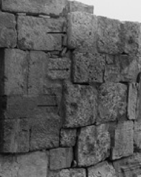 Figure 13b
Examples of rotation Counterclockwise rotation (on 5°) of a part of a ENE (62°) trending wall at the House of Frescoes. Korjenkov and Mazor (2003) 13c  Figure 13c
Examples of rotation Direction and angle of rotation observed at the upper parts of walls, the Byzantine period, as a function of the trend of the walls – a clear directional preference is observable, leading to the conclusion. Korjenkov and Mazor (2003) 13d  Figure 13d
Examples of rotation Indicating the seismic push arrived from SW Korjenkov and Mazor (2003) |
Observed damage pattern: A 4° clockwise rotation is seen in the upper part of a N-S (172°) trending wall, situated in a room of the Late Nabatean Building (Fig. 13 a). In contrast, a counterclockwise rotation of 5° is seen in part of an E-W (62°) trending wall in the House of Frescoes (Fig. 13 b).- Korzhenkov and Mazor (2003) |
| Effect | Location | Image(s) | Description |
|---|---|---|---|
| Blocking of Entrances | West City Wall
Figure 2a City plan of ancient Mamshit Korjenkov and Mazor (2003) XII quarter
Figure 2cEast Church and House of Frescoes Quarters Roman numbers denote residential quarters Arabic numbers the location of Figures Korjenkov and Mazor (2003) |
14a
 Figure 14a
Examples of rebuilding Blockage by smaller stones to support a damaged entrance at the west city wall, close to the SW corner – tilted stones at the south (right) side of the entrance indicate damage (marked by dashed lines) during a previous earthquake. Korjenkov and Mazor (2003) 14b 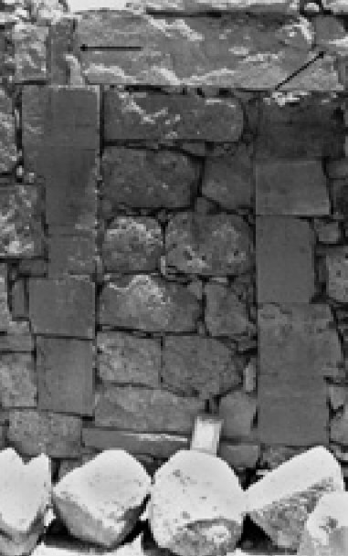 Figure 14b
Examples of rebuilding Blocking of an entrance in the east wall of a room in the XII quarter, in order to support the lintel that was cracked (marked by arrows) at an earlier earthquake. Korjenkov and Mazor (2003) |
Observation: Fig. 14 a depicts a gate in the western city wall, close to its SW corner, that was blocked by smaller stones. The wall edge is tilted towards the former entrance, disclosing that the latter was blocked in order to support the wall that was damaged, most probably by an earthquake. The blocking stones are tilted as well, possibly disclosing the impact of another earthquake. Fig. 14 b shows an entrance in the eastern wall of a room of the XII quarter that was blocked to support the lintel that was cracked (marked by arrows), most possibly during a former earthquake.- Korzhenkov and Mazor (2003) |
| Mismatch of Lower Stone Rows and Upper Parts of Buildings | E of East Church
Figure 2c East Church and House of Frescoes Quarters Roman numbers denote residential quarters Arabic numbers the location of Figures Korjenkov and Mazor (2003) |
15
 Figure 15
Rebuilding disclosed by the protrusion of the lowest row of stones at the west wall of a room, east of the East Church (the recent restoration line is higher above – marked by arrows) Korjenkov and Mazor (2003) |
Observation: The lower row of stones of the western wall of a room, east of the East Church, protrudes from the plane of the rest of the wall (Fig. 15).- Korzhenkov and Mazor (2003) |
| Supporting Walls | South City Wall
Figure 2a City plan of ancient Mamshit Korjenkov and Mazor (2003) |
16
 Figure 16
A 66° trending section of the south city wall, tilted by 81° to SES (marked by a dashed line), supported by an added wall (shown by an arrow). Part of the support wall was dissembled during the archeological excavations, to expose the tilting of the original wall Korjenkov and Mazor (2003) |
Observation: Fig. 16 discloses a section of the southern city wall (trending 66°) that is tilted by 81° to SES (marked by a dashed line), and connected to it are seen the remains of a special support wall (shown by an arrow). Part of the support wall was dissembled during the archeological excavations, to expose the tilting of the original wall.- Korzhenkov and Mazor (2003) |
| Secondary Use of Building Stones | East Church
Figure 2c East Church and House of Frescoes Quarters Roman numbers denote residential quarters Arabic numbers the location of Figures Korjenkov and Mazor (2003) |
17a
 Figure 17a
Examples of secondary use of building stones Section of a column reused as part of a bench along the west wall of the main hall of the East Church. Korjenkov and Mazor (2003) 17b  Figure 17b
Examples of secondary use of building stones E wall of a room at East Church Quarter: the lower-right part protrudes 7 to 12cm, as compared to the upper-left part, that is built of reused smaller stones (the contact is marked by + signs) Korjenkov and Mazor (2003) |
Observation: Fig. 17 a shows a secondary use of a segment of a column, western wall of the main hall of the East Church. Fig. 17 b displays the eastern wall of a room at the East Church quarter, disclosing a lower- right part that protrudes 7 to 12cm, as compared to the upper-left part that is built of reused smaller stones, disclosing a stage of repair and rebuilding.- Korzhenkov and Mazor (2003) |
| Incorporation of Wooden Beams in Stone Buildings | Administrative Tower
Figure 2b The West Church and Administrative Tower Quarters Roman numbers denote residential quarters Arabic numbers the location of Figures Korjenkov and Mazor (2003) |
18a
 Figure 18a
Examples of the incorporation of elastic wooden beams in stone buildings Wooden beam incorporated as second lintel above a door in a room at the Administrative Tower Korjenkov and Mazor (2003) 18b  Figure 18b
Examples of the incorporation of elastic wooden beams in stone buildings Wooden beam incorporated at the same building between two doorsteps Korjenkov and Mazor (2003) |
Observation: A high quality wooden beam is incorporated as a second lintel above a door in a room at the Administrative Tower (Fig. 18 a). Another beam is incorporated in the same building between two door steps (Fig. 18 b).- Korzhenkov and Mazor (2003) |
| Bulging of Wall Parts | West City Wall
Figure 2a City plan of ancient Mamshit Korjenkov and Mazor (2003) |
19a
 Figure 19a
Westward bulging of the central part of the western city wall, trending SES (152°). Korjenkov and Mazor (2003) 19b  Figure 19b
The angles of the displaced stones Korjenkov and Mazor (2003) |
Observation: The central part of the western city wall, trending SES (152°), is bulged westwards, as is seen in Fig. 19 in a photo and a sketch.- Korzhenkov and Mazor (2003) |
| Percentage of Heavily Damaged Buildings | Entire Site | Practically all the buildings of the Byzantine period were damaged, more that 50% are estimated to have been destroyed. Thus, the intensity of the tremor was IX at the EMS-98 scale or more.- Korzhenkov and Mazor (2003) |
- Fig. 20a - Seismic movement
from NWN in Early Byzantine Quake which does not match observations - from Korzhenkov and Mazor (2003)
 Figure 20a
Analysis of the direction of the epicenter in the devastating earthquake of the 4th cent. Systematic of expected damage patterns
a. If the seismic movement would have arrived from NWN
Korjenkov and Mazor (2003) - Fig. 20b - Seismic movement
from NEN in Early Byzantine Quake which does not match observations - from Korzhenkov and Mazor (2003)
 Figure 20b
Analysis of the direction of the epicenter in the devastating earthquake of the 4th cent. Systematic of expected damage patterns
b. If the epicenter would have been at NEN
Korjenkov and Mazor (2003) - Fig. 20c - Seismic movement
from N in Early Byzantine Quake which matches observations - from Korzhenkov and Mazor (2003)
 Figure 20c
Analysis of the direction of the epicenter in the devastating earthquake of the 4th cent. Systematic of expected damage patterns
c. If the seismic movement came from north – the case met by the observations
Korjenkov and Mazor (2003)
The Lower Parts of the Buildings, Reflecting Mainly the Earthquake of the End of the 3rd cent. or Beginning of the 4th cent.
The walls of the houses of Mamshit had a general orientation of around ENE (~ 75°) and SES (~165°). Hence, a quadrangle of these directions may serve as the basis for a general discussion of the observed damage patterns, in order to deduce the direction of arrival of the seismic movements.
Arrival of the seismic motions from north has been concluded for the 4th cent. event. Let us discuss in this context three possibilities:
- If the strong seismic pulses would have arrived from NWN, the walls perpendicular to this direction (ENE) would experience quantitative and systematic tilting (as well as collapse) toward the epicenter, whereas the perpendicular walls (SES) would have distinctly less cases of tilting and they would be in random to both NEN and NWN (Fig. 20 a). Rotations would be scarce and at random directions. This is not the case of the lower parts of buildings (Roman period) at Mamshit.
- If the strong seismic shocks would have arrived along the bisector of the trend of the walls (i.e. from NEN), the walls trending ENE would have undergone both systematic tilting toward NWN and anticlockwise rotation, whereas the perpendicular walls (trending SES) would experience systematic tilting toward NEN and clockwise rotation (Fig. 20 b), but this is not the case of the lower parts of buildings (Roman period) at Mamshit.
- If the epicenter was at the north, the ENE trending walls would undergo systematic tilting to the NWN and systematic counterclockwise rotations, whereas the SES trending walls would suffer of a few cases of random tilting but systematic clockwise rotations (Fig. 20 c). This combination of damage pattern orientations fits the observations at the lower parts of the buildings at Mamshit, leading to the conclusion that the epicenter of the devastating earthquake at the end of the 3rd cent. or beginning of the 4th cent. was north of Mamshit.
- Fig. 21a - Seismic movement
from WSW in 2nd Earthquake which does not match observations - from Korzhenkov and Mazor (2003)
 Figure 21a
Analysis of the direction of the epicenter in the devastating earthquake of the 7th cent. Systematic of expected damage patterns
a. If the epicenter would be at WSW
Korjenkov and Mazor (2003) - Fig. 21b - Seismic movement
from NEN in 2nd Earthquake which does not match observations - from Korzhenkov and Mazor (2003)
 Figure 21b
Analysis of the direction of the epicenter in the devastating earthquake of the 7th cent. Systematic of expected damage patterns
b. If the seismic waves would have come from NEN
Korjenkov and Mazor (2003) - Fig. 21c - Seismic movement
from SW in 2nd Earthquake which matches observations - from Korzhenkov and Mazor (2003)
 Figure 21c
Analysis of the direction of the epicenter in the devastating earthquake of the 7th cent. Systematic of expected damage patterns
c. If the seismic movement came from SW – the case met by the observations
Korjenkov and Mazor (2003)
The Upper Parts of the Buildings, Reflecting Mainly the 7th cent. Earthquake [JW: 5th -7th centuries CE ?]
The direction of the epicenter of the 7th cent. strong earthquake has been concluded to have been SW of Mamshit. In this connection let us examine three possibilities, bearing in mind that the walls of the houses of Mamshit had a general orientation of around ENE (~ 75°) and SES (~165°):
- If the strong seismic shocks would have arrived from WSW, the walls perpendicular to this direction (SES) would experience quantitative and systematic tilting toward the epicenter, whereas the perpendicular walls (ENE) would have distinctly less cases of tilting and they would be in random directions and not to the epicenter (Fig. 21 a). Rotations would be scarce and at random directions. This is not the case of the upper parts of buildings (Byzantine period) at Mamshit.
- If the strong seismic pulses would have arrived along the bisector of the trend of the walls (i.e. from SWS), the walls trending ENE would have under¬gone both systematic tilting toward NWN and counterclockwise rotation, whereas the perpendicular walls (trending SES) would experience systematic tilting toward NEN and clockwise rotation (Fig. 21 b), but this is not the case of the upper parts of buildings (Byzantine period) at Mamshit.
- If the epicenter was at SW, the SES trending walls would undergo systematic tilting to the SW and systematic clockwise rotations, whereas the ENE trending walls would suffer of a few cases of random tilting but systematic counterclockwise rotations (Fig. 21 c). This combination of damage pattern orientations fits the observations at the upper parts of the buildings at Mamshit, leading to the conclusion that the epicenter of the devastating seventh century earthquake was SW of Mamshit.
- Modified by JW from Plan 1 of Negev (1988b)
 Deformation Map
Modified by JW from Plan 1 of Negev (1988b)
- Modified by JW from Mampsis site plan in Stern et. al. (1993 v.3)
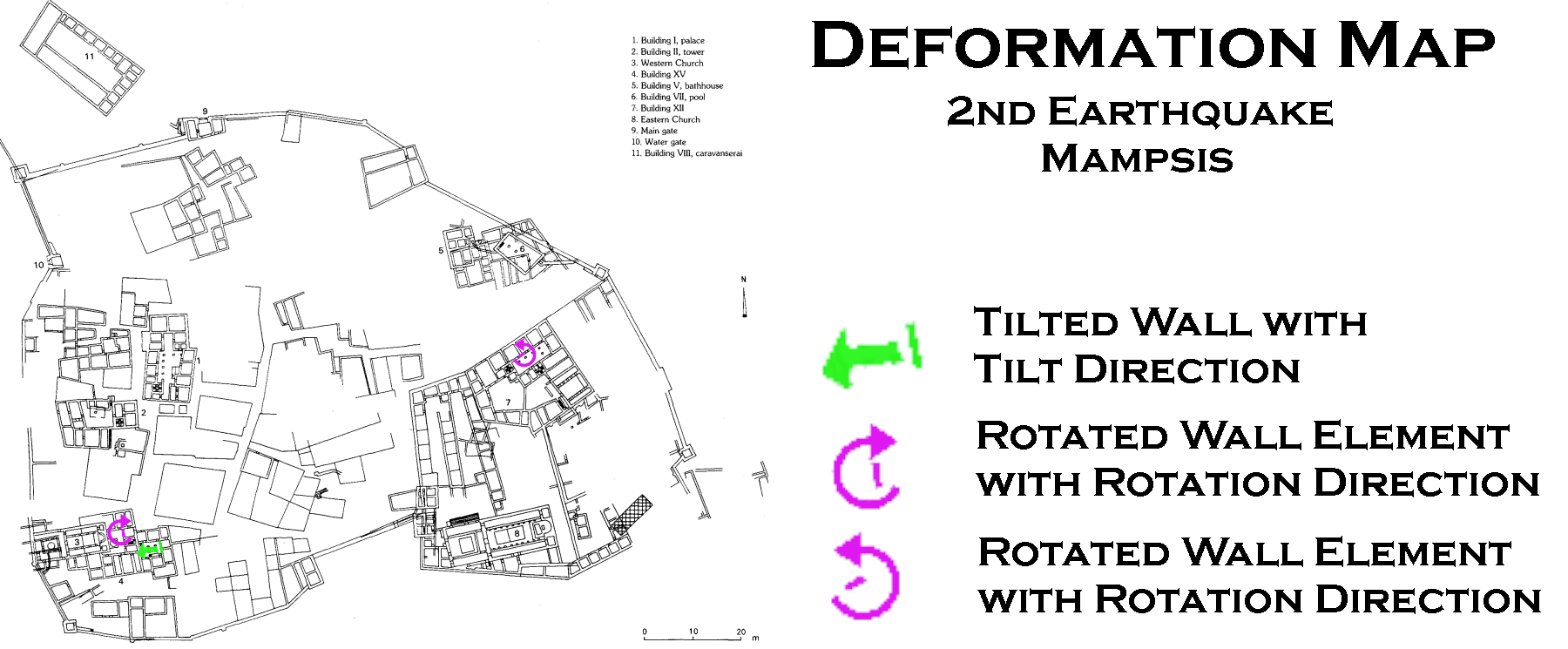 Deformation Map
Modified by JW from Mampsis site plan in Stern et. al. (1993 v.3)
- from Lower parts of buildings (built in Nabatean and Roman Periods)
- Earthquake Archeological Effects (EAE) chart
of Rodríguez-Pascua et al (2013: 221-224)
 Earthquake Archeological Effects (EAE)
Rodríguez-Pascua et al (2013: 221-224)
| Effect | Location | Image(s) | Description | Intensity |
|---|---|---|---|---|
| Systematic Tilting of Walls | E of West Church
Figure 2b The West Church and Administrative Tower Quarters Roman numbers denote residential quarters Arabic numbers the location of Figures Korjenkov and Mazor (2003) Entire Site |
3a
Figure 3a Tilted walls. South side of the north wall of a room east of the west Church, the wall has a trend of 86° and the average inclination is 79°. Korjenkov and Mazor (2003) 3b
Figure 3bTilted walls. North side of the same wall, the lower stone rows are tilted northward by up to 60° Korjenkov and Mazor (2003) 3c
Figure 3cTilted walls. Summary of measurements: direction of tilting patterns observed at the lower parts of walls at Mamshit (Tab. 1), as a function of the direction of the walls, revealing that out of 30 cases of walls trending ENE (55° to 105°), 26 were found to be tilted northward, 180 and only 4 cases are tilted southward, whereas the perpendicular walls (trending 145° to 185°) show only 9 tilting cases with no preferred direction Korjenkov and Mazor (2003) 3d
Figure 3dTilted walls. Stress directions concluded from the observed tilting patterns Korjenkov and Mazor (2003) |
Observed damage pattern: tilted walls or wall segments (Figs. 3 a. b). By convention, the direction of tilting is defined by the direction pointed by the upper part of the tilted segment. Only cases of tilting of most of the wall were included in this study.- Korzhenkov and Mazor (2003) |
VI+ |
| Lateral Shifting of Building Elements (displaced masonry blocks) | E of West Church
Figure 2b The West Church and Administrative Tower Quarters Roman numbers denote residential quarters Arabic numbers the location of Figures Korjenkov and Mazor (2003) |
4
Figure 4 Lower stone of a N-S trending (175°) arch, shifted 8cm northward (the original position is marked by dashed lines). This is the fourth arch of the eastern line of fodder-basins of the Stables. The lowest stone of the arch has been severely cracked during the seismically caused shifting Korjenkov and Mazor (2003) |
Observed damage pattern: northward shifting by 8 cm, as well as severe cracking of the lowest stone in a 175° trending arch (Fig.4). Thus, a large building element was shifted, and in addition slightly rotated clockwise. The location is at the eastern line of fodder-basins of a complex of stables, at a residential quarter east of the West Church.- Korzhenkov and Mazor (2003) |
VIII+ |
| Rotation of Wall Fragments around a Vertical Axis (displaced masonry blocks) | ENE of West Church
Figure 2b The West Church and Administrative Tower Quarters Roman numbers denote residential quarters Arabic numbers the location of Figures Korjenkov and Mazor (2003) Near Frescoes House
Figure 2cEast Church and House of Frescoes Quarters Roman numbers denote residential quarters Arabic numbers the location of Figures Korjenkov and Mazor (2003) Entire Site |
5a
Figure 5a Rotation patterns at walls of the Roman period. Clockwise rotation of stones of the lowest row of a 172° trending wall of a room ENE of the West Church; stone A was rotated by 5° and stone B by 10°, the horizontal displacement of the two stones being 21.5cm. Korjenkov and Mazor (2003) 5b
Figure 5bRotation patterns at walls of the Roman period. A 2° counterclockwise rotation of stones in the lower part of a 59° trending wall at a yard near the Frescoes House. Korjenkov and Mazor (2003) 5c
Figure 5cRotation patterns at walls of the Roman period. Angle of rotation as a function of wall trends: SES (150°-185°) trending walls reveal mainly clockwise rotation, whereas walls trending NEN (60°-95°) reveal mainly counterclockwise rotations Korjenkov and Mazor (2003) 5d
Figure 5dRotation patterns at walls of the Roman period. Stress directions concluded from the observed rotation patterns Korjenkov and Mazor (2003) |
Observed damage pattern: 1. An example of clockwise rotation of stones within a wall trending 172°, in a room located ENE of the West Church (Fig. 5 a). Stone A was rotated 5° clockwise and stone B was rotated 10° clockwise, the horizontal displacement between these rotated stones being 21.5 cm.. An example of a counterclockwise rotation in the northern wall of the Frescoes House (Fig. 5 b); the trend of the wall was 59° and the azimuth of the rotated wall fragment is 57°.- Korzhenkov and Mazor (2003) |
VIII+ |
| Cracking of Door Steps, Staircases and Lintels (penetrative fractures) | Administrative Tower
Figure 2b The West Church and Administrative Tower Quarters Roman numbers denote residential quarters Arabic numbers the location of Figures Korjenkov and Mazor (2003) E of West Church
Figure 2bThe West Church and Administrative Tower Quarters Roman numbers denote residential quarters Arabic numbers the location of Figures Korjenkov and Mazor (2003) Entire Site |
6a
Figure 6a Cracks in the southern (left) edge of a doorstep and the southern doorpost, at an entrance trending N-S (175°), leading to a room west of the Administrative Tower. Korjenkov and Mazor (2003) 6b
Figure 6bA similar set of cracks in the entrance to a room east of the Administrative Tower. Korjenkov and Mazor (2003) 6c
Figure 6cStress directions concluded from the observed cracked patterns, disclosing movement of the adjacent walls Korjenkov and Mazor (2003) 7a
Figure 7aOpen cracks at the bottom and closed cracks at the top of a E-W (83°) trending staircase inside a Late Nabatean Building, and tilted side walls Korjenkov and Mazor (2003) 7b
Figure 7bStress directions concluded from the observed open and closed crack patterns, disclosing northward movement of southern walls. Thus the seismic push arrived from north Korjenkov and Mazor (2003) 8
Figure 8Number of cracks observed in doorsteps, staircases and lintels as a function of the direction of the latter. The number of observations in N-S structures is three times greater than the observations in the perpendicular walls, leading to the conclusion that the seismic shock arrived from north Korjenkov and Mazor (2003) |
Observed damage pattern: A 175° trending doorstep of the entrance into one of the rooms of the Administrative Tower was cracked at its southern part (Fig. 6 a) and a similar damage pattern is seen in the doorstep of another room, located eastward within the same building (Fig. 6 b).- Korzhenkov and Mazor (2003) |
VI+ |
| Slipped Keystones of Arches (arch damage) | W of Eastern Church
Figure 2c East Church and House of Frescoes Quarters Roman numbers denote residential quarters Arabic numbers the location of Figures Korjenkov and Mazor (2003) Stables - E of West Church
Figure 2bThe West Church and Administrative Tower Quarters Roman numbers denote residential quarters Arabic numbers the location of Figures Korjenkov and Mazor (2003) |
9a
Figure 9a Keystone, slipped down 6cm in a N-S (174°) trending arch in a room west of the Eastern Church Korjenkov and Mazor (2003)
Dropped Keystone of MamshitRear View Long Shot Photo by Jefferson Williams 12 Jan. 2023 9b
Figure 9bTwo central stones, slipped 3cm down in an N-S (175°) trending arch above the third fodder-basin in the Stables Korjenkov and Mazor (2003) 9c
Figure 9cDiagram of the operating stresses, leading to the conclusion that the seismic wave propagation was approximately parallel to the damaged arches, i.e. along a N-S direction Korjenkov and Mazor (2003) |
Observed damage pattern: A 174° trending arch, located in a room west of the Eastern Church, exhibits a keystone that slipped 6cm down of its original position, as can be seen in Fig. 9 a. A pair of keystones slipped 3cm down in a 175° trending arch located above the third fodder-basin in the Stables (Fig. 9 b). An important auxiliary observation is that in these cases the arches themselves were not deformed.- Korzhenkov and Mazor (2003) |
VI+ |
| Jointing (penetrative fractures in masonry blocks) | Administrative Tower
Figure 2b The West Church and Administrative Tower Quarters Roman numbers denote residential quarters Arabic numbers the location of Figures Korjenkov and Mazor (2003) |
10a
Figure 10a Examples of jointing A 88cm joint crossing two adjacent stones in the West wall (175° trending) of the Administrative Tower Korjenkov and Mazor (2003) 10b
Figure 10bExamples of jointing A 70cm joint crossing the lower part of a 178° trending arch support in a courtyard west of the Administrative Tower. Such joints are indication of a strong earthquake, around VII–VIII in the EMS-98 scale Korjenkov and Mazor (2003) |
Observed damage pattern: At the western wall of the Administrative Tower, trending 178°, an 88cm long joint is seen crossing two stones (Fig.10 a). A 70cm long joint is seen at the lower support stone of a 178° trending arch, located in a room west of the Administrative Tower (Fig.10 b).- Korzhenkov and Mazor (2003) |
VI+ |
| Pushing of Walls by Connected Perpendicular Walls (displaced walls) | Entire site | 11
Figure 11 Both, clockwise and counterclock-wise rotations of adjacent stones in a wall, caused by a strong seismic push of a connected perpendicular wall Korjenkov and Mazor (2003) |
Observed damage pattern: Clockwise and counterclockwise rotations of adjacent stones in a wall, caused by a push of a connected perpendicular wall (Fig. 11).- Korzhenkov and Mazor (2003) |
VII+ |
|
Building XXV
Figure 1.64 Mampsis, Building XXV, plan and photo to east Sion and Israeli (2022) |
Figure 1.66b in situ braziers made of inverted “Gaza” wine jars found in Phase 3, 363 CE from Building XXV, Mampsis Sion and Israeli (2022)
Figure 1.67Finds from the kitchen in Phase 3 of Building XXV destroyed in the 363 CE earthquake at Mampsis Sion and Israeli (2022) |
JW: Building XXV was said to have been particularly hard hit. This building, according to
Erickson-Gini (2010:129), sustained such heavy damage that it was abandoned and never rebuilt. Room 2, apparently used as a kitchen, preserved a rich lode of pottery sealed and found in situ on the floor of the collapsed room. Some of the pottery was interpreted as having fallen from shelves in the "kitchen". Erickson-Gini (2010:80) reports that in situ coins were found in the earthquake debris in Building XXV. Erickson-Gini (2010:129) reports that the walls of adjacent Rooms 1 and 2 ("kitchen") of Building XXV were rather insubstantial additions to the original structurewhich were constructed in a shallow layer of soilwhich appears to have contributed to the collapse of the kitchen. |
|
- Fig. 5 - Damaged Arch
of Mamshit from Kamai and Hatzor (2005)
 Figure 5
The damaged arch at Mamshit
- The arch is embedded in a very heterogenic wall
- The Keystone has slid 4 cm. downwards while the rest of the arch remained intact.
Kamai and Hatzor (2005) - Fig. 6 - Numerical Model
from Kamai and Hatzor (2005)
 Figure 6
The final mesh configuration for the embedded arch in Mamshit. The uniform masonry wall rests on two blocks: the lower is fixed, and the overlying block can be subjected to time-dependant displacements. The height of the wall above the arch is h.
Kamai and Hatzor (2005) - Fig. 11 - Optimal (Final)
Model Simulation from Kamai and Hatzor (2005)
 Figure 11
The result of the dynamic block system response under an earthquake with A = 0.5 g and f = 1 Hz. The accumulating downwards displacement of the keystone is 3.11 cm.
Kamai and Hatzor (2005)
Kamai and Hatzor (2005) performed Discontinuous Deformation Analysis (DDA) on a model (Fig. 6) for a dropped keystone in an arch near the Eastern Church in Mampsis. The optimal (final) model simulation (Fig. 11), using a sinusoidal input with an amplitude of 0.5 g and a frequency of 1 Hz., produced 3.11 cm. of displacement vs. 4 cm. measured in the field. The conclusion was that the keystone dropped due an earthquake with a PGA of ~0.5 g and a center frequency of ~1 Hz.. 0.5 g translates to an Intensity of 8.2 using Equation 2 of Wald et al (1999). In their modeling, Kamai and Hatzor (2005) found that low frequencies (e.g. 0.5 Hz.) resulted in
strong fluctuationsand high frequencies (e.g. 5 and 10 Hz.) resulted in
a "locking" of the structure and very little displacement. Accelerations between 0.32 and 0.8 g produced reasonable values of keystone displacement although 0.5 g produced the most amount of displacement and the closest amount of displacement to what is observed in the field.
Kamai and Hatzor (2007) reiterated the same study at Mampsis noting that keystone displacement only occurred in the frequency range of 1.0 - 1.5 Hz. and that seismic amplification might have been at play at the higher parts of the structure (i.e. the "Sky-scraper effect" mentioned by Korzhenkov), thus amplifying bedrock PGA by as much as 2.5. This led to a bracket of PGA values for the dropped keystone between 0.2 and 0.5 g. These PGA values convert to Intensities of 6.7 - 8.2 using Equation 2 of Wald et al (1999).
| Variable | Input | Units | Notes |
|---|---|---|---|
| g | Peak Horizontal Ground Acceleration | ||
| Variable | Output - Site Effect not considered | Units | Notes |
| unitless | Conversion from PGA to Intensity using Wald et al (1999) |
- from Upper parts of buildings (repaired and built in the Byzantine Period)
- Earthquake Archeological Effects (EAE) chart
of Rodríguez-Pascua et al (2013: 221-224)
Earthquake Archeological Effects (EAE)
Rodríguez-Pascua et al (2013: 221-224)
| Effect | Location | Image(s) | Description | Intensity |
|---|---|---|---|---|
| Tilting of Walls | S of West Church
Figure 2b The West Church and Administrative Tower Quarters Roman numbers denote residential quarters Arabic numbers the location of Figures Korjenkov and Mazor (2003) Entire Site |
12a
Figure 12a Upper stones tilted 75° westward at a N-S (176°) trending wall, located at the west in a room south of the West Church Korjenkov and Mazor (2003) 12b
Figure 12bTilting westward of upper stones of the N-S (174°) trending east wall in a room south of the main premises of the West Church – stone A has a dip of 61° and stone B has a dip of 74° Korjenkov and Mazor (2003) 12c
Figure 12cTilting direction of the upper parts of walls of the Byzantine period, as a function of the wall directions – an overwhelming portion of the SES trending walls has been tilted to the WNW, and significantly less cases are seen in the perpendicular walls and with no direction preference Korjenkov and Mazor (2003) 12d
Figure 12dIndicating the seismic push arrived from SW Korjenkov and Mazor (2003) |
Observed damage pattern: The upper row of stones of a N-S (176°) trending wall, in a room south of the West Church, is tilted westward by an angle of 75° (Fig. 12 a). The upper stones of a wall trending N-S (174°), in a room south of the premises of the West Church, are also tilted westward, in an angle of 75° (Fig. 12 b).- Korzhenkov and Mazor (2003) |
VI+ |
| Rotation of Wall Fragments around a Vertical Axis (displaced masonry blocks) | E of West Church
Figure 2b The West Church and Administrative Tower Quarters Roman numbers denote residential quarters Arabic numbers the location of Figures Korjenkov and Mazor (2003) House of Frescoes
Figure 2cEast Church and House of Frescoes Quarters Roman numbers denote residential quarters Arabic numbers the location of Figures Korjenkov and Mazor (2003) Entire Site |
13a
Figure 13a Examples of rotation Clockwise rotation (on 4°) of stones in the upper part of a N-S (172°) trending wall in a room at the Late Nabatean Building Korjenkov and Mazor (2003) 13b
Figure 13bExamples of rotation Counterclockwise rotation (on 5°) of a part of a ENE (62°) trending wall at the House of Frescoes. Korjenkov and Mazor (2003) 13c
Figure 13cExamples of rotation Direction and angle of rotation observed at the upper parts of walls, the Byzantine period, as a function of the trend of the walls – a clear directional preference is observable, leading to the conclusion. Korjenkov and Mazor (2003) 13d
Figure 13dExamples of rotation Indicating the seismic push arrived from SW Korjenkov and Mazor (2003) |
Observed damage pattern: A 4° clockwise rotation is seen in the upper part of a N-S (172°) trending wall, situated in a room of the Late Nabatean Building (Fig. 13 a). In contrast, a counterclockwise rotation of 5° is seen in part of an E-W (62°) trending wall in the House of Frescoes (Fig. 13 b).- Korzhenkov and Mazor (2003) |
VIII+ |
| Description | Photo |
|---|---|
| Dropped Keystone of Mamshit Front View Long Shot |
 Dropped Keystone of Mamshit
Front View Long Shot Photo by Jefferson Williams 12 Jan. 2023 |
| Dropped Keystone of Mamshit Rear View Long Shot |
Dropped Keystone of Mamshit Rear View Long Shot Photo by Jefferson Williams 12 Jan. 2023 |
| Dropped Keystone of Mamshit Front View Closeup |
 Dropped Keystone of Mamshit
Front View Closeup Photo by Jefferson Williams 12 Jan. 2023 |
| Dropped Keystone of Mamshit Orientation Az = 174° |
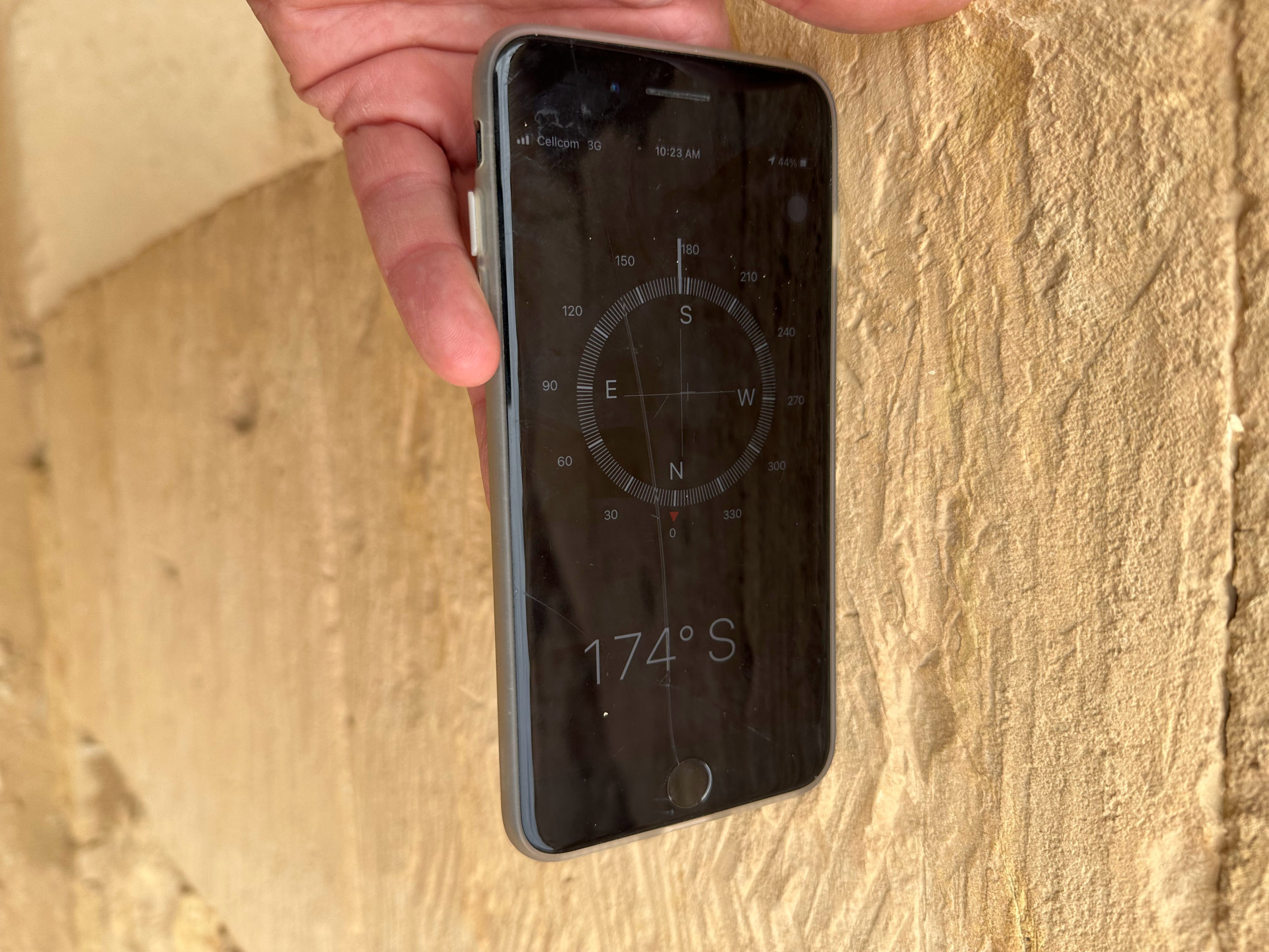 Dropped Keystone of Mamshit
Orientation Az = 174° Photo by Jefferson Williams 12 Jan. 2023 |
| Arch of Dropped Keystone of Mamshit Corner Crack of Voussoir |
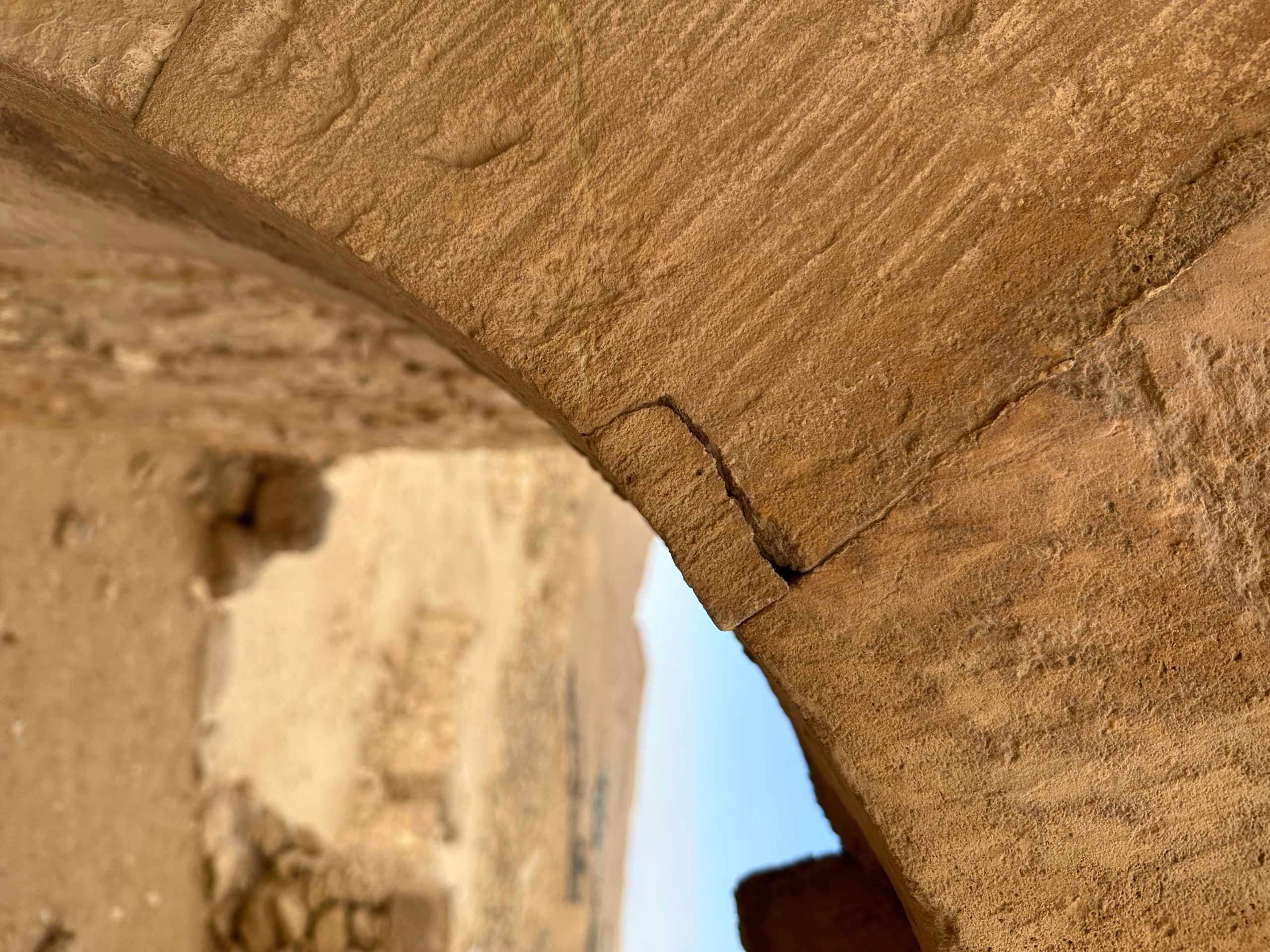 Arch of Dropped Keystone of Mamshit
Corner Crack of Voussoir Photo by Jefferson Williams 12 Jan. 2023 |
| Arch of Dropped Keystone of Mamshit Corner Crack of Voussoir - another side |
 Arch of Dropped Keystone of Mamshit
Corner Crack of Voussoir - another side Photo by Jefferson Williams 12 Jan. 2023 |
| Arch of Dropped Keystone of Mamshit Closeup on Spalled Voussoir |
 Arch of Dropped Keystone of Mamshit
Closeup on Spalled Voussoir Photo by Jefferson Williams 12 Jan. 2023 |
| Cracked Lintel in Mamshit Orientation not recorded Long Shot |
 Cracked Lintel in Mamshit
Orientation not recorded Long Shot Photo by Jefferson Williams 12 Jan. 2023 |