Mezad Yeruham
 Mezad Yeruham on govmap.gov.il
click on image to explore this site on a new tab in govmap.gov.il
| Transliterated Name | Source | Name |
|---|---|---|
| Mezad Yeruham, Mezad Yeroham | Hebrew | |
| Qasr Rekhmeh | Arabic | |
| Wády Rakhmeh | Arabic |
- Location Map from
Stern et. al. (1993 v.3)
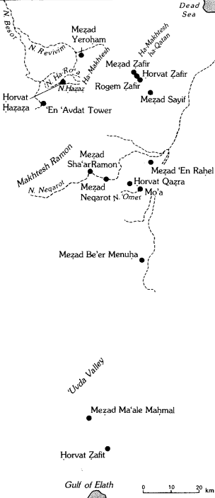 Map of the main Hellenistic, Roman, and Byzantine sites in the Negev Hills
Stern et. al. (1993 v.3) - Fig. 1.1 Location Map
from Tal et al. (2025)
 Figure 1.1
Location Map
Click on image to open in a new tab
Tal et al. (2025) - Fig. 1.2 Terrain model
(DEM) of Meẓad Yeroḥam from Tal et al. (2025)
 Figure 1.2
Terrain model (DEM) of Meẓad Yeroḥam based on LiDAR data
Click on image to open in a new tab
Tal et al. (2025)
- Location Map from
Stern et. al. (1993 v.3)
Map of the main Hellenistic, Roman, and Byzantine sites in the Negev Hills
Stern et. al. (1993 v.3) - Fig. 1.1 Location Map
from Tal et al. (2025)
Figure 1.1
Location Map
Click on image to open in a new tab
Tal et al. (2025) - Fig. 1.2 Terrain model
(DEM) of Meẓad Yeroḥam from Tal et al. (2025)
Figure 1.2
Terrain model (DEM) of Meẓad Yeroḥam based on LiDAR data
Click on image to open in a new tab
Tal et al. (2025)
- Aerial View of Mezad Yeroham
from Stern et. al. (1993 v.3)
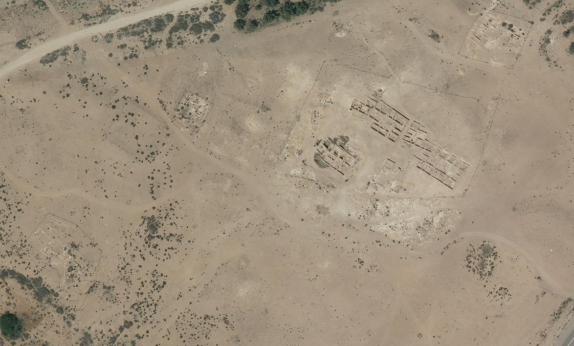
 Mezad Yeroham: aerial view of the site and vicinity.
Stern et. al. (1993 v.3) - Fig. 1.3 Aerial photograph
of the site as taken after the 1966–1967 excavations from Tal et al. (2025)
 Figure 1.3
Aerial photograph of the site as taken after the 1966–1967 excavations
Click on image to open in a new tab
Tal et al. (2025) - Mezad Yeruham in Google Earth
 Mezad Yeruham in Google Earth
click on image to explore this site on a new tab in Google Earth - Mezad Yeruham on govmap.gov.il
Mezad Yeruham on govmap.gov.il
click on image to explore this site on a new tab in govmap.gov.il
- Fig. 2.1 Site plan from
Tal et al. (2025)
 Figure 2.1
Site plan
Click on image to open in a new tab
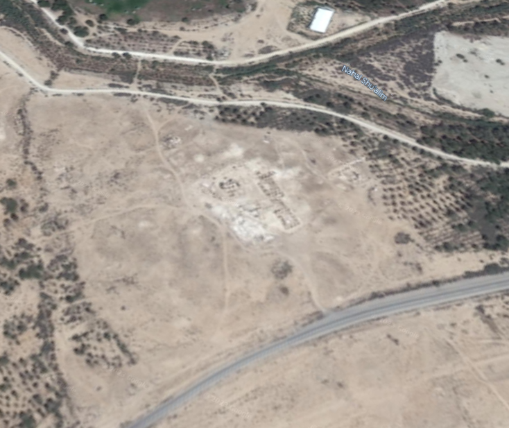
Tal et al. (2025) - Fig. 2.2 Aerial photograph
with excavation areas from Tal et al. (2025)
 Figure 2.2
Aerial photograph of the site at present
Click on image to open in a new tab
Tal et al. (2025)
- Fig. 2.1 Site plan from
Tal et al. (2025)
Figure 2.1
Site plan
Click on image to open in a new tab
Tal et al. (2025) - Fig. 2.2 Aerial photograph
with excavation areas from Tal et al. (2025)
Figure 2.2
Aerial photograph of the site at present
Click on image to open in a new tab
Tal et al. (2025)
- Fig. 2.3 Photo of Area
A from Tal et al. (2025)
 Figure 2.3
Area A, general view, looking north
Click on image to open in a new tab
Tal et al. (2025) - Fig. 2.4 Area A, area
plan from Tal et al. (2025)
 Figure 2.4
Area A, area plan
Click on image to open in a new tab
Tal et al. (2025)
- Fig. 2.3 Photo of Area
A from Tal et al. (2025)
Figure 2.3
Area A, general view, looking north
Click on image to open in a new tab
Tal et al. (2025) - Fig. 2.4 Area A, area
plan from Tal et al. (2025)
Figure 2.4
Area A, area plan
Click on image to open in a new tab
Tal et al. (2025)
- Fig. 2.18 Photo of Area B
from Tal et al. (2025)
 Figure 2.18
Area B, general view, looking northeast
Click on image to open in a new tab
Tal et al. (2025) - Fig. 2.17 Area B
from Tal et al. (2025)
 Figure 2.17
Area B, area plan with the 1993 and 2000 excavation seasons extensions framed
Click on image to open in a new tab
Tal et al. (2025) - Fig. 2.19 Area B,
Buildings I–VI from Tal et al. (2025)
 Figure 2.19
Area B, Buildings I–VI
Click on image to open in a new tab
Tal et al. (2025) - Fig. 2.20 Area B,
plan of Building I from Tal et al. (2025)
 Figure 2.20
Area B, plan of Building I
Click on image to open in a new tab
Tal et al. (2025) - Fig. 2.30a Area B,
plan of Building II from Tal et al. (2025)
 Figure 2.30a
Area B, plan of Building II
Click on image to open in a new tab
Tal et al. (2025) - Fig. 2.57 Area B,
plan of Building III from Tal et al. (2025)
 Figure 2.57
Area B, plan of Building III
Click on image to open in a new tab
Tal et al. (2025) - Fig. 2.58 Area B, Building III
from Tal et al. (2025)
 Figure 2.18
Area B, Building III, general view, looking northwest
38 Click on image to open in a new tab
Tal et al. (2025) - Fig. 2.63a Area B,
plan of Building IV from Tal et al. (2025)
 Figure 2.63a
Area B, plan of Building IV
Click on image to open in a new tab
Tal et al. (2025) - Fig. 2.77 Area B,
plan of Building V from Tal et al. (2025)
 Figure 2.77
Area B, plan of Building V
Click on image to open in a new tab
Tal et al. (2025) - Fig. 2.102a Area B,
plan of Building VI from Tal et al. (2025)
 Figure 2.102a
Area B, plan of Building VI
Click on image to open in a new tab
Tal et al. (2025)
- Fig. 2.18 Photo of Area B
from Tal et al. (2025)
Figure 2.18
Area B, general view, looking northeast
Click on image to open in a new tab
Tal et al. (2025) - Fig. 2.17 Area B
from Tal et al. (2025)
Figure 2.17
Area B, area plan with the 1993 and 2000 excavation seasons extensions framed
Click on image to open in a new tab
Tal et al. (2025) - Fig. 2.19 Area B,
Buildings I–VI from Tal et al. (2025)
Figure 2.19
Area B, Buildings I–VI
Click on image to open in a new tab
Tal et al. (2025) - Fig. 2.20 Area B,
plan of Building I from Tal et al. (2025)
Figure 2.20
Area B, plan of Building I
Click on image to open in a new tab
Tal et al. (2025) - Fig. 2.30a Area B,
plan of Building II from Tal et al. (2025)
Figure 2.30a
Area B, plan of Building II
Click on image to open in a new tab
Tal et al. (2025) - Fig. 2.57 Area B,
plan of Building III from Tal et al. (2025)
Figure 2.57
Area B, plan of Building III
Click on image to open in a new tab
Tal et al. (2025) - Fig. 2.58 Area B, Building III
from Tal et al. (2025)
Figure 2.18
Area B, Building III, general view, looking northwest
38 Click on image to open in a new tab
Tal et al. (2025) - Fig. 2.63a Area B,
plan of Building IV from Tal et al. (2025)
Figure 2.63a
Area B, plan of Building IV
Click on image to open in a new tab
Tal et al. (2025) - Fig. 2.77 Area B,
plan of Building V from Tal et al. (2025)
Figure 2.77
Area B, plan of Building V
Click on image to open in a new tab
Tal et al. (2025) - Fig. 2.102a Area B,
plan of Building VI from Tal et al. (2025)
Figure 2.102a
Area B, plan of Building VI
Click on image to open in a new tab
Tal et al. (2025)
- Fig. 2.9 Fallen Arch
in Area A from Tal et al. (2025)
 Figure 2.9
Area A, fallen arch, looking east
Click on image to open in a new tab
Tal et al. (2025) - Fig. 2.13 base (plinth)
and colonnette in Area A Room 2 from Tal et al. (2025)
 Figure 2.13
Area A, Room 2, base (plinth) and colonnette
Click on image to open in a new tab
Tal et al. (2025) - Fig. 2.37 colonette
and capital in Area B, Building II, Room 21 from Tal et al. (2025)
 Figure 2.37
Area B, Building II, Room 21, colonette and capital
Click on image to open in a new tab
Tal et al. (2025) - Fig. 2.44 Fallen arch stones
in Area B, Building II, Room 24 from Tal et al. (2025)
 Figure 2.44
Area B, Building II, Room 24, looking west (opening on right)
Click on image to open in a new tab
Tal et al. (2025) - Fig. 2.45 Fallen arch stones
in Area B, Building II, Room 24 from Tal et al. (2025)
 Figure 2.45
Area B, Building II, Room 24, looking west
Click on image to open in a new tab
Tal et al. (2025) - Fig. 2.47 Through-going crack
in Area B, Building II, Room 40 from Tal et al. (2025)
 Figure 2.47
Area B, Building II, Room 40, remains of a built pilaster
Click on image to open in a new tab
Tal et al. (2025) - Fig. 2.74 Area B, Building IV,
Room 60, pilaster from Tal et al. (2025)
 Figure 2.74
Area B, Building IV, Room 60, pilaster
Click on image to open in a new tab
Tal et al. (2025) - Fig. 2.82 Broken Ashlar in
Area B, Building V, from Tal et al. (2025)
 Figure 2.82
Area B, Building V, building stone with incised palm branches
Click on image to open in a new tab
Tal et al. (2025) - Fig. 2.86 Tilted Wall
(possibly due to soil pressure) in Area B, Building V, Chamber 99 from Tal et al. (2025)
 Figure 2.86
Area B, Building V, Chamber 99, looking north
Click on image to open in a new tab
Tal et al. (2025) - Fig. 2.89 Broken lintel in
Area B, Building V, Room 95 from Tal et al. (2025)
 Figure 2.89
Area B, Building V, Room 95, lintels
Click on image to open in a new tab
Tal et al. (2025) - Fig. 2.107 Collapse in Area
B, Building VI, Locus 504 from Tal et al. (2025)
 Figure 2.107
Area B, Building VI, Locus 504, looking northwest
Click on image to open in a new tab
Tal et al. (2025) - Fig. 2.108 Broken lintel
from Area B, Building VI, Room 120 from Tal et al. (2025)
 Figure 2.108
Area B, Building VI, Room 120, lintel
Click on image to open in a new tab
Tal et al. (2025) - Fig. 2.115 Area C, Room 155
from Tal et al. (2025)
 Figure 2.115
Area C, Room 155, looking northeast
Click on image to open in a new tab
Tal et al. (2025) - Fig. 2.116 Area C, Room 155
from Tal et al. (2025)
 Figure 2.116
Area C, Room 155, looking northwest
Click on image to open in a new tab
Tal et al. (2025) - Fig. 2.124 Fallen arches in
Area C, Room 186 from Tal et al. (2025)
 Figure 2.124
Area C, Room 186, looking northwest
Click on image to open in a new tab
Tal et al. (2025)
- Fig. 2.9 Fallen Arch
in Area A from Tal et al. (2025)
Figure 2.9
Area A, fallen arch, looking east
Click on image to open in a new tab
Tal et al. (2025) - Fig. 2.13 base (plinth)
and colonnette in Area A Room 2 from Tal et al. (2025)
Figure 2.13
Area A, Room 2, base (plinth) and colonnette
Click on image to open in a new tab
Tal et al. (2025) - Fig. 2.37 colonette
and capital in Area B, Building II, Room 21 from Tal et al. (2025)
Figure 2.37
Area B, Building II, Room 21, colonette and capital
Click on image to open in a new tab
Tal et al. (2025) - Fig. 2.44 Fallen arch stones
in Area B, Building II, Room 24 from Tal et al. (2025)
Figure 2.44
Area B, Building II, Room 24, looking west (opening on right)
Click on image to open in a new tab
Tal et al. (2025) - Fig. 2.45 Fallen arch stones
in Area B, Building II, Room 24 from Tal et al. (2025)
Figure 2.45
Area B, Building II, Room 24, looking west
Click on image to open in a new tab
Tal et al. (2025) - Fig. 2.47 Through-going crack
in Area B, Building II, Room 40 from Tal et al. (2025)
Figure 2.47
Area B, Building II, Room 40, remains of a built pilaster
Click on image to open in a new tab
Tal et al. (2025) - Fig. 2.74 Area B, Building IV,
Room 60, pilaster from Tal et al. (2025)
Figure 2.74
Area B, Building IV, Room 60, pilaster
Click on image to open in a new tab
Tal et al. (2025) - Fig. 2.82 Broken Ashlar in
Area B, Building V, from Tal et al. (2025)
Figure 2.82
Area B, Building V, building stone with incised palm branches
Click on image to open in a new tab
Tal et al. (2025) - Fig. 2.86 Tilted Wall
(possibly due to soil pressure) in Area B, Building V, Chamber 99 from Tal et al. (2025)
Figure 2.86
Area B, Building V, Chamber 99, looking north
Click on image to open in a new tab
Tal et al. (2025) - Fig. 2.89 Broken lintel in
Area B, Building V, Room 95 from Tal et al. (2025)
Figure 2.89
Area B, Building V, Room 95, lintels
Click on image to open in a new tab
Tal et al. (2025) - Fig. 2.107 Collapse in Area
B, Building VI, Locus 504 from Tal et al. (2025)
Figure 2.107
Area B, Building VI, Locus 504, looking northwest
Click on image to open in a new tab
Tal et al. (2025) - Fig. 2.108 Broken lintel
from Area B, Building VI, Room 120 from Tal et al. (2025)
Figure 2.108
Area B, Building VI, Room 120, lintel
Click on image to open in a new tab
Tal et al. (2025) - Fig. 2.115 Area C, Room 155
from Tal et al. (2025)
Figure 2.115
Area C, Room 155, looking northeast
Click on image to open in a new tab
Tal et al. (2025) - Fig. 2.116 Area C, Room 155
from Tal et al. (2025)
Figure 2.116
Area C, Room 155, looking northwest
Click on image to open in a new tab
Tal et al. (2025) - Fig. 2.124 Fallen arches in
Area C, Room 186 from Tal et al. (2025)
Figure 2.124
Area C, Room 186, looking northwest
Click on image to open in a new tab
Tal et al. (2025)
| Effect | Location | Image(s) | Description |
|---|---|---|---|
|
Building I in Area B
Figure 2.2 Aerial photograph of the site at present Click on image to open in a new tab Tal et al. (2025)
Figure 2.19Area B, Buildings I–VI Click on image to open in a new tab Tal et al. (2025)
Figure 2.20Area B, plan of Building I Click on image to open in a new tab Tal et al. (2025) |
Tal et al. (2025:25) reports that excavations in Building I of Area B show that the second phase ended, according to Baumgarten, "with an earthquake as indicated in units uncovered in Area B by both Cohen and him". Earthquake evidence included "skewed or warped walls, fallen voussoirs and of many of the gravel-made walls of the rooms". |
-
Earthquake Archeological Effects chart
of Rodríguez-Pascua et al (2013: 221-224)
 Earthquake Archeological Effects (EAE)
Rodríguez-Pascua et al (2013: 221-224)
| Effect | Location | Image(s) | Description | Intensity |
|---|---|---|---|---|
|
Building I in Area B
Figure 2.2 Aerial photograph of the site at present Click on image to open in a new tab Tal et al. (2025)
Figure 2.19Area B, Buildings I–VI Click on image to open in a new tab Tal et al. (2025)
Figure 2.20Area B, plan of Building I Click on image to open in a new tab Tal et al. (2025) |
Tal et al. (2025:25) reports that excavations in Building I of Area B show that the second phase ended, according to Baumgarten, "with an earthquake as indicated in units uncovered in Area B by both Cohen and him". Earthquake evidence included "skewed or warped walls, fallen voussoirs and of many of the gravel-made walls of the rooms". |
|