Theodor Wiegand in Mitzpe Shivta
Spolia and Heritage Protection Along the Ottoman Military Railway
 Mizpe Shivta and environs on govmap.gov.il
| Transliterated Name | Source | Name |
|---|---|---|
| Mizpe Shivta | Hebrew | |
| Khirbet el-Misrafa | Arabic | |
| Khirbat al-Mushrayfa | Arabic | |
| el-Meshrifeh | Arabic | |
| Mesrafeh | Arabic | |
| Mishrafa | Arabic |
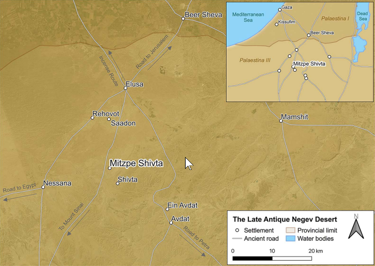 Figure 1
Figure 1
 Figure 2
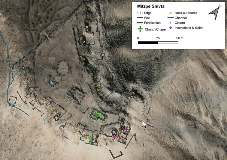 Figure 3
 Mizpe Shivta and environs in Google Earth
Mizpe Shivta and environs on govmap.gov.il
Mizpe Shivta and environs in Google Earth
Mizpe Shivta and environs on govmap.gov.il
Figure 2
Figure 3
Mizpe Shivta and environs in Google Earth
Mizpe Shivta and environs on govmap.gov.il
Figure 2
Figure 3
 Mizpe Shivta: general plan of the site.
Figure 2
Figure 3
Mizpe Shivta: general plan of the site.
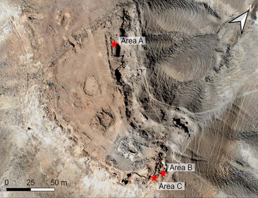 Figure 4
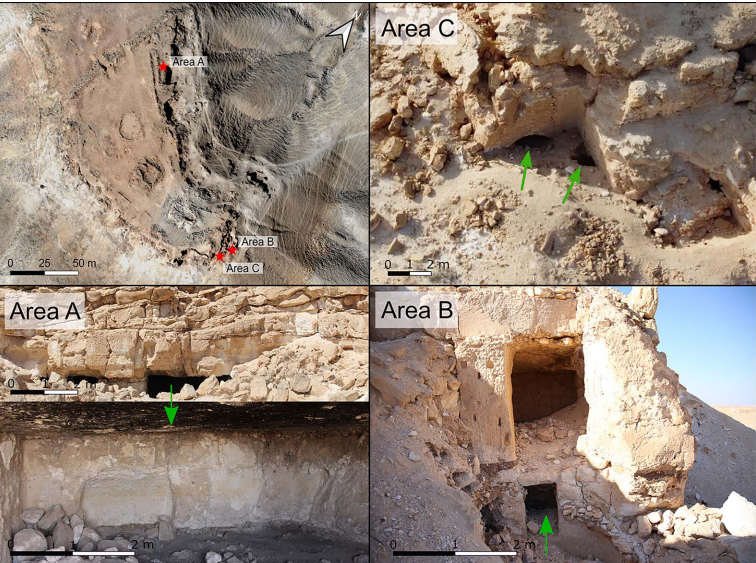 Figure 4
Figure 4
Figure 4
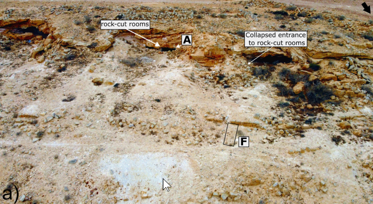 Figure 8a
Figure 8a
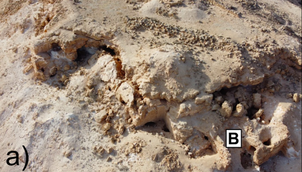 Figure 6a
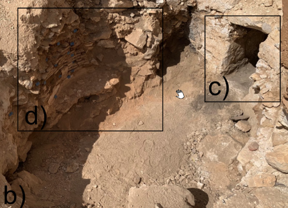 Figure 6b
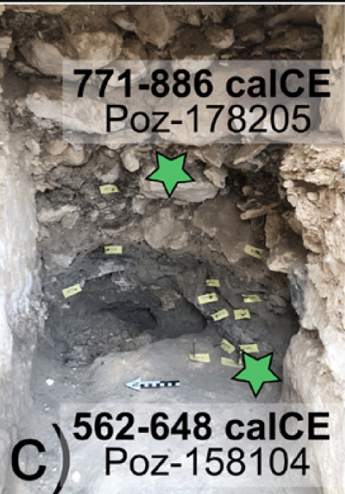 Figure 6c
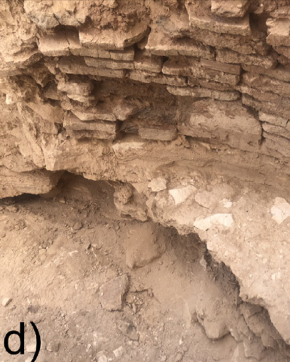 Figure 6d
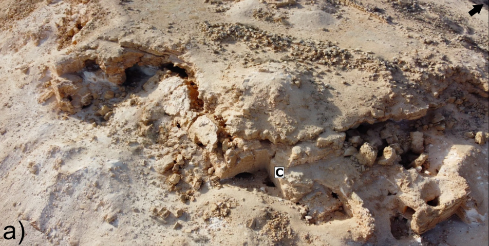 Figure 7a
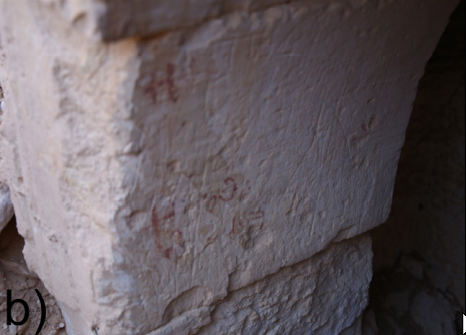 Figure 7b
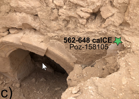 Figure 7c
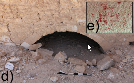 Figure 7d and 7e
 Figure 7e
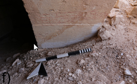 Figure 7f
Figure 8a
Figure 7f
Figure 8a
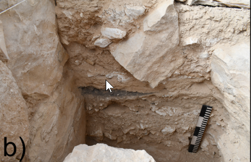 Figure 8b
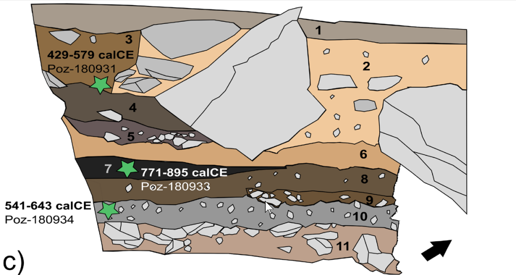 Figure 8c
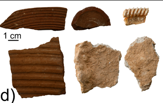 Figure 8d
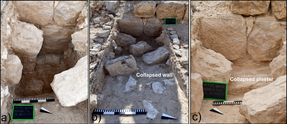 Figure 9
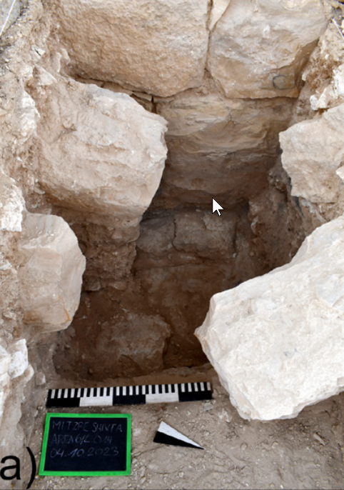 Figure 9a
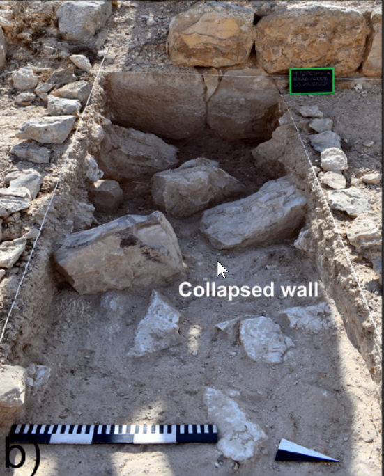 Figure 9b
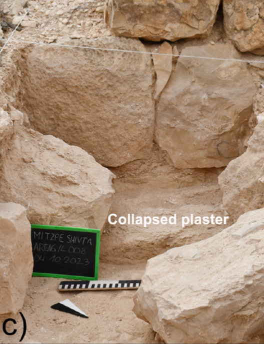 Figure 9c
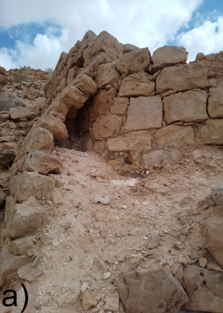 Figure 10a
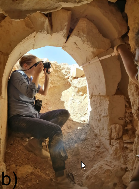 Figure 10b
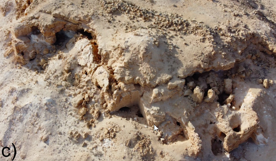 Figure 10c
Figure 6a
Figure 6b
Figure 6c
Figure 6d
Figure 7a
Figure 7b
Figure 7c
Figure 7d and 7e
Figure 7e
Figure 7f
Figure 8a
Figure 8b
Figure 8c
Figure 8d
Figure 9
Figure 9a
Figure 9b
Figure 9c
Figure 10a
Figure 10b
Figure 10c
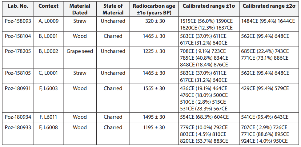 Table 1
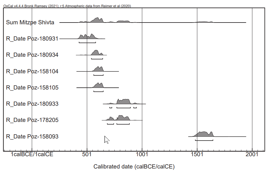 Figure 5
| Effect(s) | Location | Image(s) | Description |
|---|---|---|---|
|
Entire Site
Figure 2
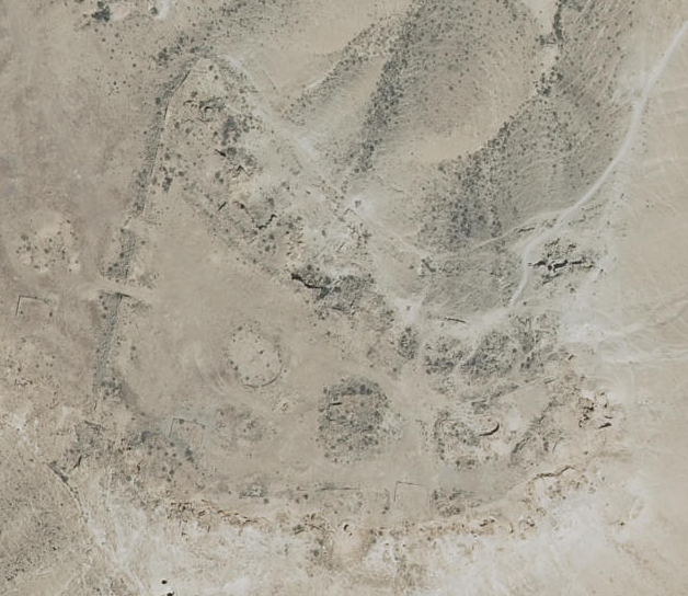
Aerial view of the site and numbers indicating main features.
(photograph by Arne Schröder) click on image to open in a new tab Lehnig et al. (2023)
Figure 3
Preliminary map of Mitzpe Shivta based on a historic aerial photograph by Theodor Wiegand (DAI-Z-AdZ-NL-Luftbild-322-1, Mishrefe) and a map of Ya‘aqov Baumgarten (1993) (figure by the authors) click on image to open in a new tab Lehnig et al. (2023)
Mizpe Shivta: general plan of the site. Stern et. al. (1993 v.3) |
Fig. 10a
Figure 10a
Retaining walls in the southwestern tower of Mitzpe Shivta; double-arch construction at the entrance to one of the rock-hewn rooms (photographs by S. Lehnig and C. Ferrara) click on image to open in a new tab Lehnig et al. (2025a) Fig. 10b
Figure 10b
Retaining walls in the southwestern tower of Mitzpe Shivta; aerial photograph of earthquake damage at the site (photographs by S. Lehnig and C. Ferrara) click on image to open in a new tab Lehnig et al. (2025a) Fig. 10c
Figure 10c
Retaining walls in the southwestern tower of Mitzpe Shivta (photographs by S. Lehnig and C. Ferrara) click on image to open in a new tab Lehnig et al. (2025a) |
|
| Effect(s) | Location | Image(s) | Description |
|---|---|---|---|
|
Area B
Figure 4
Locations of the three selected study areas:
(figure by the authors). click on image to open in a new tab Lehnig et al. (2023)
Figure 2
Aerial view of the site and numbers indicating main features.
(photograph by Arne Schröder) click on image to open in a new tab Lehnig et al. (2023)
Figure 3
Preliminary map of Mitzpe Shivta based on a historic aerial photograph by Theodor Wiegand (DAI-Z-AdZ-NL-Luftbild-322-1, Mishrefe) and a map of Ya‘aqov Baumgarten (1993) (figure by the authors) click on image to open in a new tab Lehnig et al. (2023)
Mizpe Shivta: general plan of the site. Stern et. al. (1993 v.3) Fig. 6a
Figure 6a
Location of Area B (a); cleaned looting trench (b) and subsequent excavation and sampling areas (d and c); radiocarbon dated grape seed (e); roof tile from collapse debris (f) (photographs by S. Lehnig and M. Gil). click on image to open in a new tab Lehnig et al. (2025a) Fig. 6b
Figure 6b
Location of Area B (a); cleaned looting trench (b) and subsequent excavation and sampling areas (d and c); radiocarbon dated grape seed (e); roof tile from collapse debris (f) (photographs by S. Lehnig and M. Gil). click on image to open in a new tab Lehnig et al. (2025a) |
|
|
|
Area C
Figure 4
Locations of the three selected study areas:
(figure by the authors). click on image to open in a new tab Lehnig et al. (2023)
Figure 2
Aerial view of the site and numbers indicating main features.
(photograph by Arne Schröder) click on image to open in a new tab Lehnig et al. (2023)
Figure 3
Preliminary map of Mitzpe Shivta based on a historic aerial photograph by Theodor Wiegand (DAI-Z-AdZ-NL-Luftbild-322-1, Mishrefe) and a map of Ya‘aqov Baumgarten (1993) (figure by the authors) click on image to open in a new tab Lehnig et al. (2023)
Mizpe Shivta: general plan of the site. Stern et. al. (1993 v.3) Fig. 7a
Figure 7a
Sampling locations in Area C
(photographs by S. Lehnig). click on image to open in a new tab Lehnig et al. (2025a) |
Fig. 7c
Figure 7c
Sampling locations in Area C
(photographs by S. Lehnig). click on image to open in a new tab Lehnig et al. (2025a) Fig. 7d
Figure 7d and 7e
Sampling locations in Area C
(photographs by S. Lehnig). click on image to open in a new tab Lehnig et al. (2025a) |
|
|
Area F - Area F (Fig. 8a) was opened on the northern part of the lower fortress of Mitzpe Shivta to investigate and date the building complex in front of the rock-cut space in Area A
Figure 4
Locations of the three selected study areas:
(figure by the authors). click on image to open in a new tab Lehnig et al. (2023) Fig. 8a
Figure 8a
Location of Areas A and F
(photographs by S. Lehnig, J. Linstädter). click on image to open in a new tab Lehnig et al. (2025a)
Figure 2
Aerial view of the site and numbers indicating main features.
(photograph by Arne Schröder) click on image to open in a new tab Lehnig et al. (2023)
Figure 3
Preliminary map of Mitzpe Shivta based on a historic aerial photograph by Theodor Wiegand (DAI-Z-AdZ-NL-Luftbild-322-1, Mishrefe) and a map of Ya‘aqov Baumgarten (1993) (figure by the authors) click on image to open in a new tab Lehnig et al. (2023)
Mizpe Shivta: general plan of the site. Stern et. al. (1993 v.3) |
Fig. 9
Figure 9
Collapsed wall and wall plaster documented in Area F (photographs by S. Lehnig) click on image to open in a new tab Lehnig et al. (2025a) Fig. 9a
Figure 9a
Collapsed wall and wall plaster documented in Area F (photographs by S. Lehnig) click on image to open in a new tab Lehnig et al. (2025a) Fig. 9b
Figure 9b
Collapsed wall and wall plaster documented in Area F (photographs by S. Lehnig) click on image to open in a new tab Lehnig et al. (2025a) Fig. 9c
Figure 9c
Collapsed wall and wall plaster documented in Area F (photographs by S. Lehnig) click on image to open in a new tab Lehnig et al. (2025a) Fig. 8b
Figure 8b
Location of Areas A and F
(photographs by S. Lehnig, J. Linstädter). click on image to open in a new tab Lehnig et al. (2025a) Fig. 8c
Figure 8c
Location of Areas A and F
(photographs by S. Lehnig, J. Linstädter). click on image to open in a new tab Lehnig et al. (2025a) |
|
|
Entire Site
Figure 4
Locations of the three selected study areas:
(figure by the authors). click on image to open in a new tab Lehnig et al. (2023)
Figure 8a
Location of Areas A and F
(photographs by S. Lehnig, J. Linstädter). click on image to open in a new tab Lehnig et al. (2025a)
Figure 2
Aerial view of the site and numbers indicating main features.
(photograph by Arne Schröder) click on image to open in a new tab Lehnig et al. (2023)
Figure 3
Preliminary map of Mitzpe Shivta based on a historic aerial photograph by Theodor Wiegand (DAI-Z-AdZ-NL-Luftbild-322-1, Mishrefe) and a map of Ya‘aqov Baumgarten (1993) (figure by the authors) click on image to open in a new tab Lehnig et al. (2023)
Mizpe Shivta: general plan of the site. Stern et. al. (1993 v.3) |
Fig. 10a
Figure 10a
Retaining walls in the southwestern tower of Mitzpe Shivta; double-arch construction at the entrance to one of the rock-hewn rooms (photographs by S. Lehnig and C. Ferrara) click on image to open in a new tab Lehnig et al. (2025a) Fig. 10b
Figure 10b
Retaining walls in the southwestern tower of Mitzpe Shivta; aerial photograph of earthquake damage at the site (photographs by S. Lehnig and C. Ferrara) click on image to open in a new tab Lehnig et al. (2025a) Fig. 10c
Figure 10c
Retaining walls in the southwestern tower of Mitzpe Shivta (photographs by S. Lehnig and C. Ferrara) click on image to open in a new tab Lehnig et al. (2025a) |
|
 Earthquake Archeological Effects (EAE)
| Effect(s) | Location | Image(s) | Description |
|---|---|---|---|
|
Entire Site
Figure 2
Aerial view of the site and numbers indicating main features.
(photograph by Arne Schröder) click on image to open in a new tab Lehnig et al. (2023)
Figure 3
Preliminary map of Mitzpe Shivta based on a historic aerial photograph by Theodor Wiegand (DAI-Z-AdZ-NL-Luftbild-322-1, Mishrefe) and a map of Ya‘aqov Baumgarten (1993) (figure by the authors) click on image to open in a new tab Lehnig et al. (2023)
Mizpe Shivta: general plan of the site. Stern et. al. (1993 v.3) |
Fig. 10a
Figure 10a
Retaining walls in the southwestern tower of Mitzpe Shivta; double-arch construction at the entrance to one of the rock-hewn rooms (photographs by S. Lehnig and C. Ferrara) click on image to open in a new tab Lehnig et al. (2025a) Fig. 10b
Figure 10b
Retaining walls in the southwestern tower of Mitzpe Shivta; aerial photograph of earthquake damage at the site (photographs by S. Lehnig and C. Ferrara) click on image to open in a new tab Lehnig et al. (2025a) Fig. 10c
Figure 10c
Retaining walls in the southwestern tower of Mitzpe Shivta (photographs by S. Lehnig and C. Ferrara) click on image to open in a new tab Lehnig et al. (2025a) |
|
Earthquake Archeological Effects (EAE)| Effect(s) | Location | Image(s) | Description | Intensity |
|---|---|---|---|---|
|
Area B
Figure 4
Locations of the three selected study areas:
(figure by the authors). click on image to open in a new tab Lehnig et al. (2023)
Figure 2
Aerial view of the site and numbers indicating main features.
(photograph by Arne Schröder) click on image to open in a new tab Lehnig et al. (2023)
Figure 3
Preliminary map of Mitzpe Shivta based on a historic aerial photograph by Theodor Wiegand (DAI-Z-AdZ-NL-Luftbild-322-1, Mishrefe) and a map of Ya‘aqov Baumgarten (1993) (figure by the authors) click on image to open in a new tab Lehnig et al. (2023)
Mizpe Shivta: general plan of the site. Stern et. al. (1993 v.3) Fig. 6a
Figure 6a
Location of Area B (a); cleaned looting trench (b) and subsequent excavation and sampling areas (d and c); radiocarbon dated grape seed (e); roof tile from collapse debris (f) (photographs by S. Lehnig and M. Gil). click on image to open in a new tab Lehnig et al. (2025a) Fig. 6b
Figure 6b
Location of Area B (a); cleaned looting trench (b) and subsequent excavation and sampling areas (d and c); radiocarbon dated grape seed (e); roof tile from collapse debris (f) (photographs by S. Lehnig and M. Gil). click on image to open in a new tab Lehnig et al. (2025a) |
|
|
|
|
Area C
Figure 4
Locations of the three selected study areas:
(figure by the authors). click on image to open in a new tab Lehnig et al. (2023)
Figure 2
Aerial view of the site and numbers indicating main features.
(photograph by Arne Schröder) click on image to open in a new tab Lehnig et al. (2023)
Figure 3
Preliminary map of Mitzpe Shivta based on a historic aerial photograph by Theodor Wiegand (DAI-Z-AdZ-NL-Luftbild-322-1, Mishrefe) and a map of Ya‘aqov Baumgarten (1993) (figure by the authors) click on image to open in a new tab Lehnig et al. (2023)
Mizpe Shivta: general plan of the site. Stern et. al. (1993 v.3) Fig. 7a
Figure 7a
Sampling locations in Area C
(photographs by S. Lehnig). click on image to open in a new tab Lehnig et al. (2025a) |
Fig. 7c
Figure 7c
Sampling locations in Area C
(photographs by S. Lehnig). click on image to open in a new tab Lehnig et al. (2025a) Fig. 7d
Figure 7d and 7e
Sampling locations in Area C
(photographs by S. Lehnig). click on image to open in a new tab Lehnig et al. (2025a) |
|
|
|
Area F - Area F (Fig. 8a) was opened on the northern part of the lower fortress of Mitzpe Shivta to investigate and date the building complex in front of the rock-cut space in Area A
Figure 4
Locations of the three selected study areas:
(figure by the authors). click on image to open in a new tab Lehnig et al. (2023) Fig. 8a
Figure 8a
Location of Areas A and F
(photographs by S. Lehnig, J. Linstädter). click on image to open in a new tab Lehnig et al. (2025a)
Figure 2
Aerial view of the site and numbers indicating main features.
(photograph by Arne Schröder) click on image to open in a new tab Lehnig et al. (2023)
Figure 3
Preliminary map of Mitzpe Shivta based on a historic aerial photograph by Theodor Wiegand (DAI-Z-AdZ-NL-Luftbild-322-1, Mishrefe) and a map of Ya‘aqov Baumgarten (1993) (figure by the authors) click on image to open in a new tab Lehnig et al. (2023)
Mizpe Shivta: general plan of the site. Stern et. al. (1993 v.3) |
Fig. 9
Figure 9
Collapsed wall and wall plaster documented in Area F (photographs by S. Lehnig) click on image to open in a new tab Lehnig et al. (2025a) Fig. 9a
Figure 9a
Collapsed wall and wall plaster documented in Area F (photographs by S. Lehnig) click on image to open in a new tab Lehnig et al. (2025a) Fig. 9b
Figure 9b
Collapsed wall and wall plaster documented in Area F (photographs by S. Lehnig) click on image to open in a new tab Lehnig et al. (2025a) Fig. 9c
Figure 9c
Collapsed wall and wall plaster documented in Area F (photographs by S. Lehnig) click on image to open in a new tab Lehnig et al. (2025a) Fig. 8b
Figure 8b
Location of Areas A and F
(photographs by S. Lehnig, J. Linstädter). click on image to open in a new tab Lehnig et al. (2025a) Fig. 8c
Figure 8c
Location of Areas A and F
(photographs by S. Lehnig, J. Linstädter). click on image to open in a new tab Lehnig et al. (2025a) |
|
|
|
Entire Site
Figure 4
Locations of the three selected study areas:
(figure by the authors). click on image to open in a new tab Lehnig et al. (2023)
Figure 8a
Location of Areas A and F
(photographs by S. Lehnig, J. Linstädter). click on image to open in a new tab Lehnig et al. (2025a)
Figure 2
Aerial view of the site and numbers indicating main features.
(photograph by Arne Schröder) click on image to open in a new tab Lehnig et al. (2023)
Figure 3
Preliminary map of Mitzpe Shivta based on a historic aerial photograph by Theodor Wiegand (DAI-Z-AdZ-NL-Luftbild-322-1, Mishrefe) and a map of Ya‘aqov Baumgarten (1993) (figure by the authors) click on image to open in a new tab Lehnig et al. (2023)
Mizpe Shivta: general plan of the site. Stern et. al. (1993 v.3) |
Fig. 10a
Figure 10a
Retaining walls in the southwestern tower of Mitzpe Shivta; double-arch construction at the entrance to one of the rock-hewn rooms (photographs by S. Lehnig and C. Ferrara) click on image to open in a new tab Lehnig et al. (2025a) Fig. 10b
Figure 10b
Retaining walls in the southwestern tower of Mitzpe Shivta; aerial photograph of earthquake damage at the site (photographs by S. Lehnig and C. Ferrara) click on image to open in a new tab Lehnig et al. (2025a) Fig. 10c
Figure 10c
Retaining walls in the southwestern tower of Mitzpe Shivta (photographs by S. Lehnig and C. Ferrara) click on image to open in a new tab Lehnig et al. (2025a) |
|
|