Jerash - Temple of Zeus
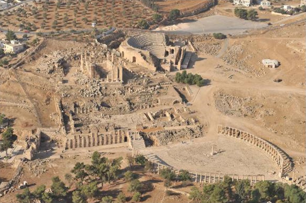 Figure 3 1.
Aerial view of Zeus Sanctuary, Oval Piazza, and South Theatre (APAAME_08.DLK-40)
Kehrberg (2018)
- Jerash Temple of Zeus in Google Earth
 Jerash Temple of Zeus
click on image to explore this site on a new tab in Google Earth

- Fig. 2 Plan of the Temple
of Zeus from Seigne (1986)
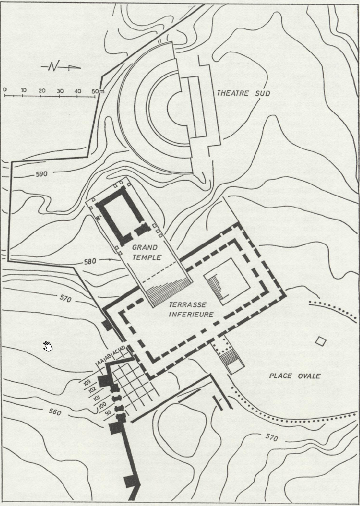 Figure 2
Plan of the Temple of Zeus
Click on image to open in a new tab
Seigne (1986) - Fig. 26 Plan of the Upper
Sanctuary of Zeus from Egan and Bikai (1998)
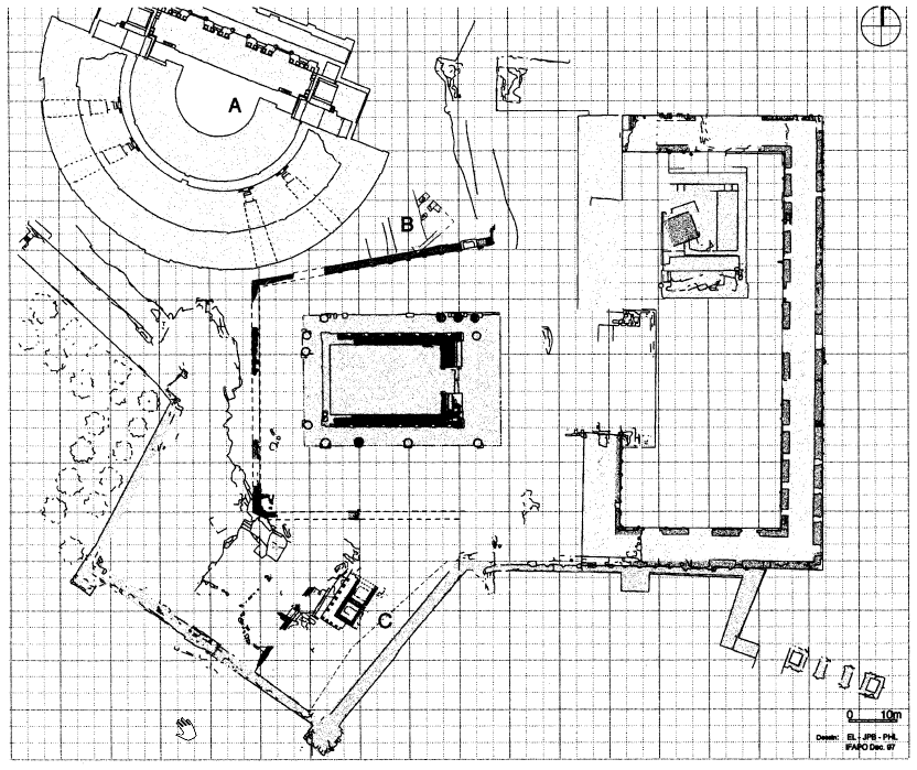 Figure 26
Gerasa. Plan of the Upper Sanctuary of Zeus showing areas of excavation in 1997
(J.P. Braun, E. Lena, and P. Lenhardt)
Click on image to open in a new tab
Egan and Bikai (1998) - Fig. 2 - Chronological
evolution of the sanctuary of Zeus at Jerash from Seigne (1985)
 Figure 2
Chronological evolution of the sanctuary of Zeus in Gerasa.
- Extension of the sanctuary around 125 BC
- Extension at the turn of BC/AD
- Extension in 27-28 AD
- Addition at the beginning of the 2nd century AD
- Addition at the beginning of the 2nd century AD
(study by J. Seigne, DAO, C. Kholmayer, Th. Lepaon)
Seigne (1985) - Plate I - Lower terrace
of the sanctuary of Zeus at Jerash from Tholbecq (2000)
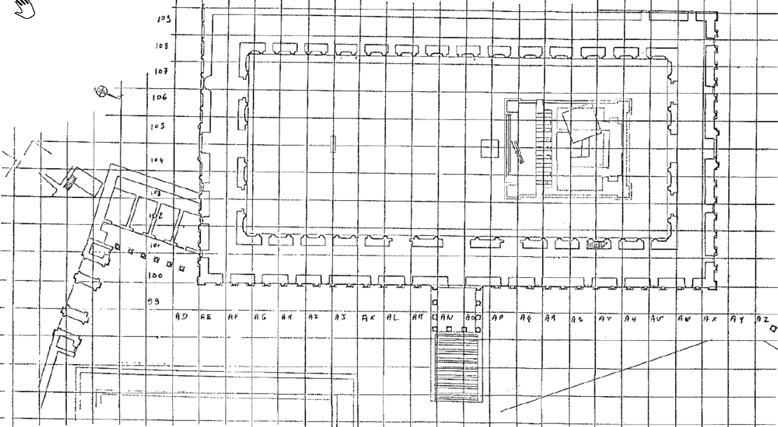 Plate I
Lower terrace of sanctuary of Zeus (Jerash). Arrangement of grid.
Tholbecq (2000) - Plate II - Late Islamic
structures in SW corner of the sanctuary of Zeus from Tholbecq (2000)
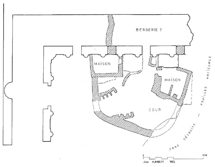 Plate II
Late Islamic structures in the southwest corner of the lower terrace of the sanctuary of Zeus (Jerash).
Tholbecq (2000)
- Fig. 2 Plan of the Temple
of Zeus from Seigne (1986)
Figure 2
Plan of the Temple of Zeus
Click on image to open in a new tab
Seigne (1986) - Fig. 26 Plan of the Upper
Sanctuary of Zeus from Egan and Bikai (1998)
Figure 26
Gerasa. Plan of the Upper Sanctuary of Zeus showing areas of excavation in 1997
(J.P. Braun, E. Lena, and P. Lenhardt)
Click on image to open in a new tab
Egan and Bikai (1998) - Fig. 2 - Chronological
evolution of the sanctuary of Zeus at Jerash from Seigne (1985)
Figure 2
Chronological evolution of the sanctuary of Zeus in Gerasa.
- Extension of the sanctuary around 125 BC
- Extension at the turn of BC/AD
- Extension in 27-28 AD
- Addition at the beginning of the 2nd century AD
- Addition at the beginning of the 2nd century AD
(study by J. Seigne, DAO, C. Kholmayer, Th. Lepaon)
Seigne (1985) - Plate I - Lower terrace
of the sanctuary of Zeus at Jerash from Tholbecq (2000)
Plate I
Lower terrace of sanctuary of Zeus (Jerash). Arrangement of grid.
Tholbecq (2000) - Plate II - Late Islamic
structures in SW corner of the sanctuary of Zeus from Tholbecq (2000)
Plate II
Late Islamic structures in the southwest corner of the lower terrace of the sanctuary of Zeus (Jerash).
Tholbecq (2000)
- Fig. 2 Site plan and
detail of the cistern from Rasson and Seigne (1989)
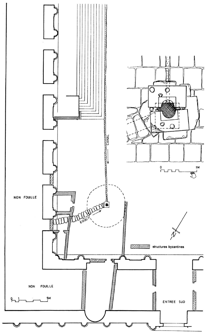 Figure 2
Site plan and detail of the cistern
(Drawing: J. Seigne)
Click on image to open in a new tab
Rasson and Seigne (1989)
- Fig. 2 Site plan and
detail of the cistern from Rasson and Seigne (1989)
Figure 2
Site plan and detail of the cistern
(Drawing: J. Seigne)
Click on image to open in a new tab
Rasson and Seigne (1989)
- Fig. 1 Evolutionary diagrams
of the sanctuary from Rasson and Seigne (1989)
Figure 1
Evolutionary diagrams of the sanctuary:
- The sanctuary area before any construction. Ilypothese (Drawing: J.-P. Lange).
- Supposed state of the sanctuary around 80/100 BC (Drawing: J. Seigne).
- Supposed state of the sanctuary around 60 BC (Drawing: J. Seigne).
- Supposed state of the sanctuary around 0 AD (Drawing: J. Seigne).
- Supposed state of the sanctuary around 30 AD (Drawing: J. Seigne).
- Supposed state of the sanctuary around 70 AD (Drawing: J. Seigne).
- Supposed state of the sanctuary around 170 AD (Drawing: M.A.F.J.).
Click on image to open in a new tab
Rasson and Seigne (1989) - Fig. 6 Illustration of
the Temple of Zeus from Seigne (1986)
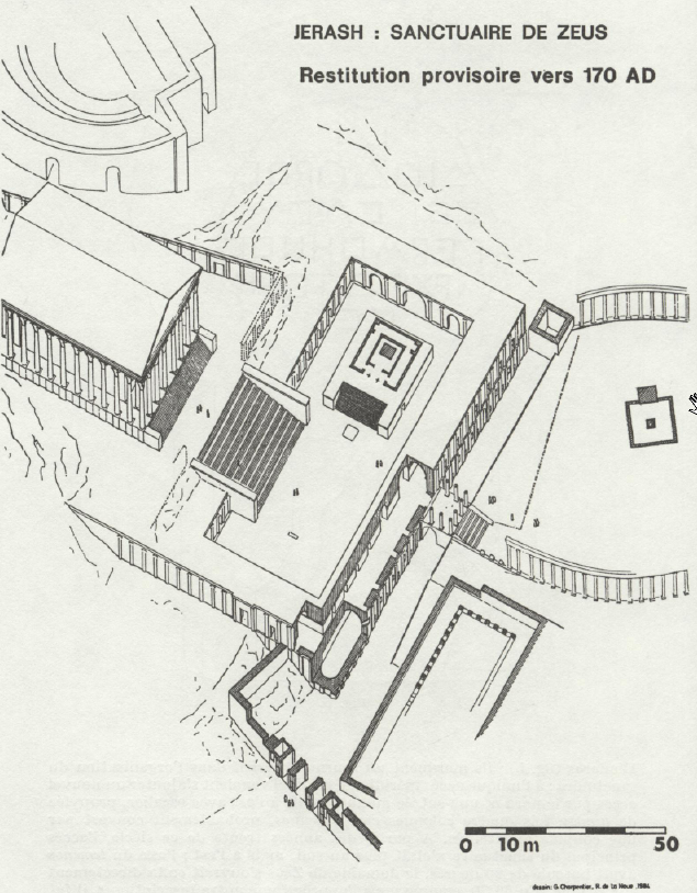 Figure 6
Illustration of the Temple of Zeus
Click on image to open in a new tab
Seigne (1986)
- Fig. 1 Evolutionary diagrams
of the sanctuary from Rasson and Seigne (1989)
Figure 1
Evolutionary diagrams of the sanctuary:
- The sanctuary area before any construction. Ilypothese (Drawing: J.-P. Lange).
- Supposed state of the sanctuary around 80/100 BC (Drawing: J. Seigne).
- Supposed state of the sanctuary around 60 BC (Drawing: J. Seigne).
- Supposed state of the sanctuary around 0 AD (Drawing: J. Seigne).
- Supposed state of the sanctuary around 30 AD (Drawing: J. Seigne).
- Supposed state of the sanctuary around 70 AD (Drawing: J. Seigne).
- Supposed state of the sanctuary around 170 AD (Drawing: M.A.F.J.).
Click on image to open in a new tab
Rasson and Seigne (1989) - Fig. 6 Illustration of
the Temple of Zeus from Seigne (1986)
Figure 6
Illustration of the Temple of Zeus
Click on image to open in a new tab
Seigne (1986)
- Fig. 4 Vertical section
of the cistern from Rasson and Seigne (1989)
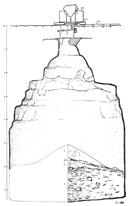 Figure 4
Vertical section of the cistern
(Drawing: J. Seigne)
Click on image to open in a new tab
Rasson and Seigne (1989)
- Fig. 4 Vertical section
of the cistern from Rasson and Seigne (1989)
Figure 4
Vertical section of the cistern
(Drawing: J. Seigne)
Click on image to open in a new tab
Rasson and Seigne (1989)
- Fig. 4 Vertical section
of the cistern from Rasson and Seigne (1989)
Figure 4
Vertical section of the cistern
(Drawing: J. Seigne)
Click on image to open in a new tab
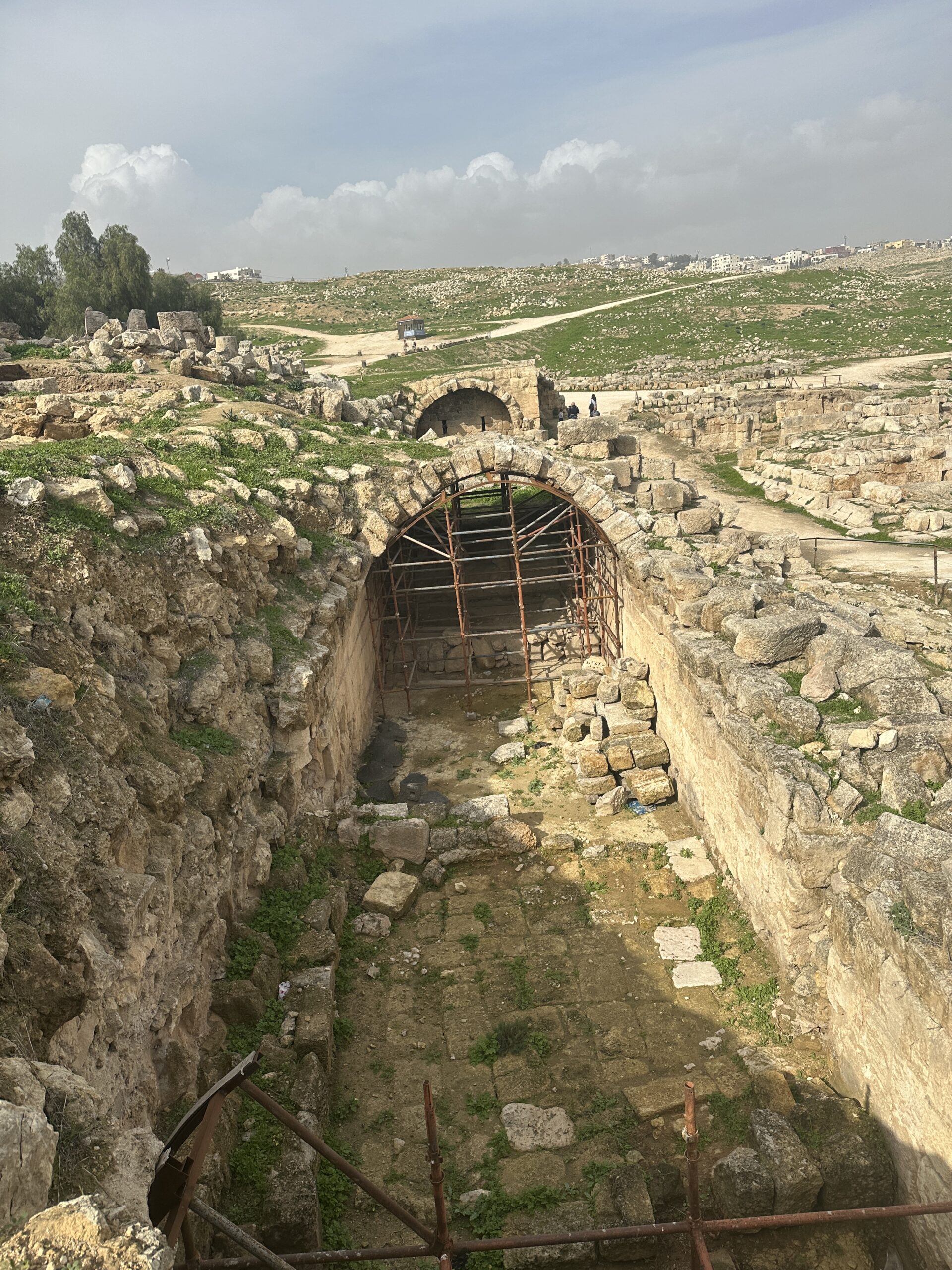
Rasson and Seigne (1989) - Vault in Lower Terrace
- photo by JW
 Lower Terrace Vault
Click on image to open in a new tab
Photo by Jefferson Williams - 24 Jan. 2026 - Vault in Lower Terrace
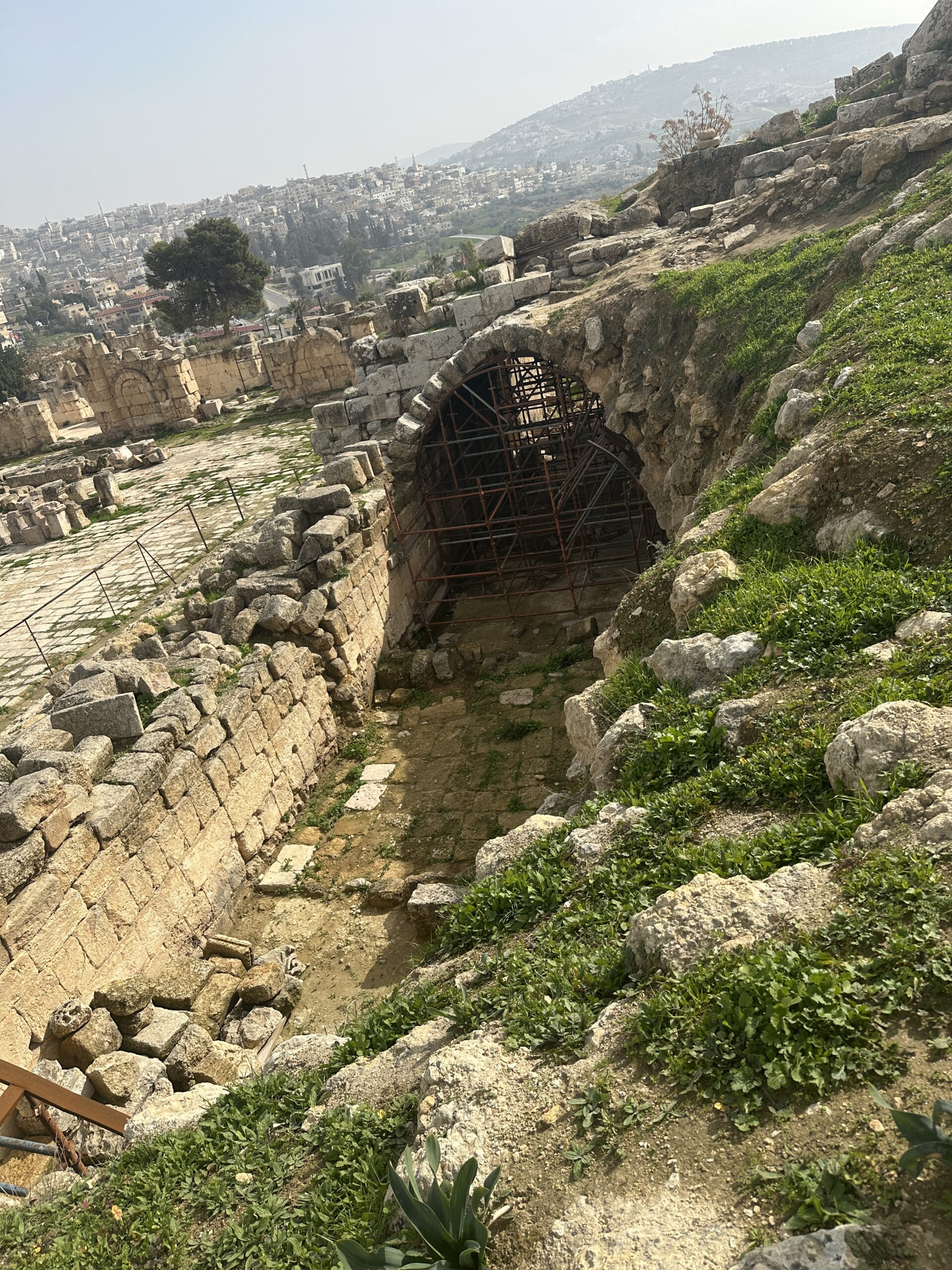
- photo by JW
 Lower Terrace Vault
Click on image to open in a new tab
Photo by Jefferson Williams - 24 Jan. 2026 - Vault in Lower Terrace
- photo by JW
 Lower Terrace Vault
Click on image to open in a new tab
Photo by Jefferson Williams - 24 Jan. 2026
- Fig. 4 Vertical section
of the cistern from Rasson and Seigne (1989)
Figure 4
Vertical section of the cistern
(Drawing: J. Seigne)
Click on image to open in a new tab
Rasson and Seigne (1989) - Vault in Lower Terrace
- photo by JW
Lower Terrace Vault
Click on image to open in a new tab
Photo by Jefferson Williams - 24 Jan. 2026 - Vault in Lower Terrace
- photo by JW
Lower Terrace Vault
Click on image to open in a new tab
Photo by Jefferson Williams - 24 Jan. 2026 - Vault in Lower Terrace
- photo by JW
Lower Terrace Vault
Click on image to open in a new tab
Photo by Jefferson Williams - 24 Jan. 2026
| Effect | Location | Image(s) | Description |
|---|---|---|---|
|
Temple of Zeus Building Complex
Figure 26 Gerasa. Plan of the Upper Sanctuary of Zeus showing areas of excavation in 1997 (J.P. Braun, E. Lena, and P. Lenhardt) Click on image to open in a new tab Egan and Bikai (1998) |
|
| Effect | Location | Image(s) | Description |
|---|---|---|---|
|
Temple of Zeus Building Complex
Figure 26 Gerasa. Plan of the Upper Sanctuary of Zeus showing areas of excavation in 1997 (J.P. Braun, E. Lena, and P. Lenhardt) Click on image to open in a new tab Egan and Bikai (1998) |
|
| Effect | Location | Image(s) | Description |
|---|---|---|---|
|
Cistern
Figure 2
Site plan and detail of the cistern (Drawing: J. Seigne) Click on image to open in a new tab Rasson and Seigne (1989) |
Figure 4
Vertical section of the cistern (Drawing: J. Seigne) Click on image to open in a new tab Rasson and Seigne (1989) |
|
|
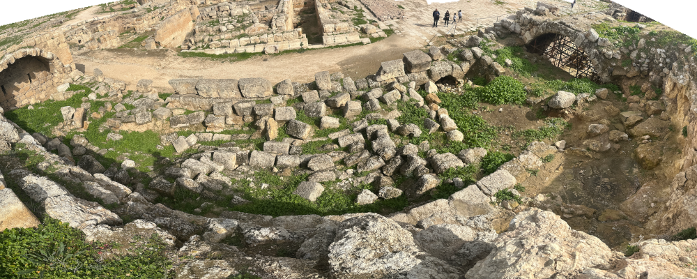
vaulted corridor of the lower terrace
Plate I Lower terrace of sanctuary of Zeus (Jerash). Arrangement of grid. Tholbecq (2000) |
|
| Effect | Location | Image(s) | Description |
|---|---|---|---|
|
architectural collapse from the facades of the sanctuary found (dumped into) in the Cistern
Figure 2
Site plan and detail of the cistern (Drawing: J. Seigne) Click on image to open in a new tab Rasson and Seigne (1989) |
Figure 4
Vertical section of the cistern (Drawing: J. Seigne) Click on image to open in a new tab Rasson and Seigne (1989) |
|
|
the Cistern
Figure 2
Site plan and detail of the cistern (Drawing: J. Seigne) Click on image to open in a new tab Rasson and Seigne (1989) |
Figure 4
Vertical section of the cistern (Drawing: J. Seigne) Click on image to open in a new tab Rasson and Seigne (1989) |
|
| Effect | Location | Image(s) | Description |
|---|---|---|---|
|
Lower Terrace
Plate I Lower terrace of sanctuary of Zeus (Jerash). Arrangement of grid. Tholbecq (2000) |
|
- Earthquake Archeological Effects chart
of Rodríguez-Pascua et al (2013: 221-224)
 Earthquake Archeological Effects (EAE)
Rodríguez-Pascua et al (2013: 221-224)
| Effect | Location | Image(s) | Description | Intensity |
|---|---|---|---|---|
|
Temple of Zeus Building Complex
Figure 26 Gerasa. Plan of the Upper Sanctuary of Zeus showing areas of excavation in 1997 (J.P. Braun, E. Lena, and P. Lenhardt) Click on image to open in a new tab Egan and Bikai (1998) |
|
|
- Earthquake Archeological Effects chart
of Rodríguez-Pascua et al (2013: 221-224)
Earthquake Archeological Effects (EAE)
Rodríguez-Pascua et al (2013: 221-224)
| Effect | Location | Image(s) | Description | Intensity |
|---|---|---|---|---|
|
Temple of Zeus Building Complex
Figure 26 Gerasa. Plan of the Upper Sanctuary of Zeus showing areas of excavation in 1997 (J.P. Braun, E. Lena, and P. Lenhardt) Click on image to open in a new tab Egan and Bikai (1998) |
|
|
-
Earthquake Archeological Effects chart
of Rodríguez-Pascua et al (2013: 221-224)
Earthquake Archeological Effects (EAE)
Rodríguez-Pascua et al (2013: 221-224)
| Effect | Location | Image(s) | Description | Intensity |
|---|---|---|---|---|
|
Cistern
Figure 2
Site plan and detail of the cistern (Drawing: J. Seigne) Click on image to open in a new tab Rasson and Seigne (1989) |
Figure 4
Vertical section of the cistern (Drawing: J. Seigne) Click on image to open in a new tab Rasson and Seigne (1989) |
|
VIII + |
|
vaulted corridor of the lower terrace
Plate I Lower terrace of sanctuary of Zeus (Jerash). Arrangement of grid. Tholbecq (2000) |
|
VIII + |
-
Earthquake Archeological Effects chart
of Rodríguez-Pascua et al (2013: 221-224)
Earthquake Archeological Effects (EAE)
Rodríguez-Pascua et al (2013: 221-224)
| Effect | Location | Image(s) | Description | Intensity |
|---|---|---|---|---|
|
architectural collapse from the facades of the sanctuary found (dumped into) in the Cistern
Figure 2
Site plan and detail of the cistern (Drawing: J. Seigne) Click on image to open in a new tab Rasson and Seigne (1989) |
Figure 4
Vertical section of the cistern (Drawing: J. Seigne) Click on image to open in a new tab Rasson and Seigne (1989) |
|
|
- Earthquake Archeological Effects chart
of Rodríguez-Pascua et al (2013: 221-224)
Earthquake Archeological Effects (EAE)
Rodríguez-Pascua et al (2013: 221-224)
| Effect | Location | Image(s) | Description | Intensity |
|---|---|---|---|---|
|
Lower Terrace
Plate I Lower terrace of sanctuary of Zeus (Jerash). Arrangement of grid. Tholbecq (2000) |
|
|
- from Lichtenberger and Raja (2025)
- Table 2.2 List of seismic damage
in Jerash between the 1st and 19th centuries CE from Lichtenberger and Raja (2025)
 Table 2.2
List of seismically induced damage recorded in Gerasa where the relaibility of the evidence is considered to be medium or high
Click on Image to open in a new tab
Lichtenberger and Raja (2025)
 Figure 2.6
Plan of ancient Gerasa showing the location of earthquake-damaged sites referred to in Table 2.2
(after Lichtenberger, Raja, and Stott 2019.fig.2)
Click on Image to open in a new tab
Lichtenberger and Raja (2025)
- from Lichtenberger and Raja (2025)
- Fig. 2.6 Map of seismic damage
in Jerash between the 1st and 19th centuries CE from Lichtenberger and Raja (2025)
Figure 2.6
Plan of ancient Geras showing the location of earthquake-damaged sites referred to in Table 2.2
(after Lichtenberger, Raja, and Stott 2019.fig.2)
Click on Image to open in a new tab
Lichtenberger and Raja (2025)
| Century (AD) | Event (AD) attribution by original author |
Reliability of interpreted evidence |
Likely attributable seismic event (AD) |
Locality | Plan ref. | Reference |
|---|---|---|---|---|---|---|
| 1st–3rd | Medium | 112 | North-west aqueduct | 5 | Passchier and others 2021. | |
| 3rd–early 4th | Medium | 363 | Zeus Temple | 13 | Egan and Bikai 1998, 598. | |
| 3rd–early 4th | Medium | 551 | East cavea of Hippodrome | 14 | Ostrasz 1989, 74–76. | |
| 6th | Late 6th | Medium | 551 | Lower terrace, Zeus Temple | 12 | Rasson and Seigne 1989, 151; Egan and Bikai 1998, 598; Rasson-Seigne and Seigne 2019. |
| 7th | 633–660 | High | 659 | Propylaea Church | 16 | Brizzi, Seipo, and Baldoni 2010, 356–57. |
| 7th | 659/660 | High | 659 | Macellum | 10 | Uscatescu 2019, 22, table 2.2. |
| 7th | 660 | Medium | 659 | Taberna, thermopolium | 6 | Baldoni 2018, 26–27; 2019, 121–22. |
| 7th | 659/660 | Medium | 659 | Hippodrome | 14 | Kehrberg and Ostrasz 1994, 546–47. |
| 7th | 659/660 | Medium | 659 | Zeus Temple–Naos corridor | 12 | Rasson-Seigne and Seigne 2019, 168. |
| 8th | 749 | High | 747–749 | Umayyad Mosque | 9 | Rattenborg and Blanke 2017. |
| 8th | 749 | High | 747–749 | House adjacent to Mosque | 3 | Rattenborg and Blanke 2017, 319–24. |
| 8th | 749 | High | 747–749 | Propylaea Church | 16 | Brizzi, Seipo, and Baldoni 2010, 358. |
| 8th | 749 | High | 747–749 | North-West Quarter, various | 1 | Jørgensen 2018; Lichtenberger and Raja 2019a, 277–78; 2019b. |
| 8th | 749 | High | 747–749 | South Decumanus, east side | 8 | Walmsley 2007, 259–61. |
| 8th | 747–749 | High | 747–749 | Beside aqueduct (site JWP111) | 18 | Boyce 2022, 74. |
| 8th | Medium | 747–749 | Bishop Marianos Church | 15 | Gawlikowski and Musa 1986, 141. | |
| 8th | 747 | Medium | 747–749 | Artemis complex | 4 | Parapetti 1989, 10; Parapetti and others 1986, 191–92. |
| 8th | 749 | Medium | 747–749 | Zeus Temple, various sites | 13 | Seigne 1986, 247; 1989, 322; Rasson-Seigne and Seigne 2019. |
| 8th | 749 | Medium | 747–749 | Bishop Isaiah Church | 2 | Clark 1990, 176. |
| 8th | 749 | Medium | 747–749 | Hippodrome | 14 | Ostrasz 2020, 33. |
| 8th | 749 | Medium | 747–749 | Large East Baths | 17 | Lepaon, Turshan, and Weber-Karyotakis 2018. |
| 9th | Post-770 | High | 854 | Umayyad House, South Decumanus | 7 | Gawlikowski 1986, 113. |
| 9th | 9th | High | 854 | Congregational Mosque | 9 | Rattenborg and Blanke 2017, 321. |
| 9th | 9th | Medium | 854 | South-West Quarter | 11 | Rattenborg and Blanke 2017, 324; Blanke 2018, 44. |
| 11th–13th | 11th–13th | Medium | ? | Zeus lower terrace | 12 | Rasson-Seigne and others 2018, 74–75. |
| 19th | 1837 | Medium | 1837 | City area (Earthquake witnessed) | Lindsay 1838, 107. |
- from Lichtenberger and Raja (2025)
- Fig. 2.6 Map of seismic damage
in Jerash between the 1st and 19th centuries CE from Lichtenberger and Raja (2025)
Figure 2.6
Plan of ancient Geras showing the location of earthquake-damaged sites referred to in Table 2.2
(after Lichtenberger, Raja, and Stott 2019.fig.2)
Click on Image to open in a new tab
Lichtenberger and Raja (2025)
Table 2.2List of seismically induced damage recorded in Gerasa where the relaibility of the evidence is considered to be medium or high
Click on Image to open in a new tab
Lichtenberger and Raja (2025)
 Table 2.11
List of seismic events with median epicentres within a 200 km radius of Gcrasa (Jerash) between 31 BC and AD 1900 with movement magnitude (Mw) > 6.0 (data from Grigoratos and others 2020).
Click on Image to open in a new tab
Lichtenberger and Raja (2025)