Avdat/Oboda

 Left
LeftOrthophoto of Avdat
Click on Image to open a high resolution magnifiable map in a new tab
www.govmap.gov.il.
Right
Oblique Aerial View of Avdat Acropolis
Click on Image to open a high resolution magnifiable image in a new tab
Etan Tal (איתן טל) - German Wikipedia - CC BY-SA 3.0
| Transliterated Name | Source | Name |
|---|---|---|
| Avdat | Hebrew | עבדת |
| Abdah, Abde | Arabic | عبدة |
| Oboda | Ancient Greek | Ὀβόδα |
| Ovdat | ||
| Obodat |
- Terrain Map of Avdat
showing how the site may be subject to a ridge effect
 Terrain Map for Avdat/Oboda
click on image to see this in a new tab in Google Maps
- Annotated Satellite Image (google) of
Avdat from biblewalks.com
- Fig. 1 Aerial Overview of
Avdat from Zion et al (2022)

Figure 1
Avdat, looking east
- Army Camp from Roman Period
- Residential District
- Acropolis
- Cave City Avdat - W slope
- Cave City Avdat - E slope
- Orchards and Winepresses ?
- Orchards
- Orchards
- Orchards
- "Cave of the Saints"
(Photogrammetry: Yaakov Shmidov).
Zion et al (2022) - Avdat/Oboda in Google Earth
 Avdat/Oboda
click on image to explore this site on a new tab in Google Earth - Avdat/Oboda on govmap.gov.il
Avdat/Oboda
click on image to explore this site on a new tab in govmap.gov.il

- Plan of Avdat from biblewalks.com
- Avdat Settlement Plan from
Zion et al (2022)
 Figure 3
Avdat Settlement Plan
Zion et al (2022) - Avdat/Oboda General Plan
from Avraham Negev in Stern et al, 1993
 Oboda: general plan of the site and military camp.
Stern et al (1993)

- Plan of Avdat from biblewalks.com
- Avdat Settlement Plan from
Zion et al (2022)
Figure 3
Avdat Settlement Plan
Zion et al (2022) - Avdat/Oboda General Plan
from Avraham Negev in Stern et al, 1993
Oboda: general plan of the site and military camp.
Stern et al (1993)
- Late Roman/early Byzantine
quarter occupational phases and room from Stern et al (2008)
 Late Roman/early Byzantine quarter occupational phases and rooms
Stern et al (2008) - Fig. 1.72 Plan and Photo
of Late Roman / Early Byzantine Quarter from Erickson-Gini (2010)
 Fig. 1.72
Oboda Late Roman / Early Byzantine Quarter, 1999-2000 excavations, plan and photo
Erickson-Gini (2010) - Fig. 1.73 Plan of
of Late Roman/Early Byzantine Quarter with Phases and Rooms from Erickson-Gini (2010)
 Fig. 1.73
Oboda Late Roman / Early Byzantine Quarter, occupational phases and rooms
Erickson-Gini (2010) - Fig. 1.77 Detailed Plan of
Late Roman/Early Byzantine Quarter from Erickson-Gini (2010)
 Fig. 1.77
Oboda Late Roman / Early Byzantine Quarter, 1999-2000 excavations
Erickson-Gini (2010)
- Late Roman/early Byzantine
quarter occupational phases and room from Stern et al (2008)
Late Roman/early Byzantine quarter occupational phases and rooms
Stern et al (2008) - Fig. 1.72 Plan and Photo
of Late Roman / Early Byzantine Quarter from Erickson-Gini (2010)
Fig. 1.72
Oboda Late Roman / Early Byzantine Quarter, 1999-2000 excavations, plan and photo
Erickson-Gini (2010) - Fig. 1.73 Plan of
of Late Roman/Early Byzantine Quarter with Phases and Rooms from Erickson-Gini (2010)
Fig. 1.73
Oboda Late Roman / Early Byzantine Quarter, occupational phases and rooms
Erickson-Gini (2010) - Fig. 1.77 Detailed Plan of
Late Roman/Early Byzantine Quarter from Erickson-Gini (2010)
Fig. 1.77
Oboda Late Roman / Early Byzantine Quarter, 1999-2000 excavations
Erickson-Gini (2010)
- Fig. 1 Excavation Areas A, B,
and D from Erickson-Gini (2022)
 Fig. 1
The excavation areas
Erickson-Gini (2022) - Plan 1 Area A from
Erickson-Gini (2022)
 Plan 1
Area A
Erickson-Gini (2022) - Plan 2 Area B, plan
and sections from Erickson-Gini (2022)
 Plan 2
Area B, plan and sections
Erickson-Gini (2022)
- Fig. 1 Excavation Areas A, B,
and D from Erickson-Gini (2022)
Fig. 1
The excavation areas
Erickson-Gini (2022) - Plan 1 Area A from
Erickson-Gini (2022)
Plan 1
Area A
Erickson-Gini (2022) - Plan 2 Area B, plan
and sections from Erickson-Gini (2022)
Plan 2
Area B, plan and sections
Erickson-Gini (2022)
- Fig. 1 Excavation Areas A, B,
and D from Erickson-Gini (2022)
Fig. 1
The excavation areas
Erickson-Gini (2022) - Plan 3 plan of dipinti
Cave in Area D from Erickson-Gini (2022)
 Plan 3
Area D, plan of the Dipinti Cave.
Erickson-Gini (2022)
- Fig. 1 Excavation Areas A, B,
and D from Erickson-Gini (2022)
Fig. 1
The excavation areas
Erickson-Gini (2022) - Plan 3 plan of dipinti
Cave in Area D from Erickson-Gini (2022)
Plan 3
Area D, plan of the Dipinti Cave.
Erickson-Gini (2022)
- Fig. 1.70 Army Camp from
Erickson-Gini (2010)
 Fig. 1.70
The 1999 excavation of the army camp at Oboda
Erickson-Gini (2010)
- Fig. 1.70 Army Camp from
Erickson-Gini (2010)
Fig. 1.70
The 1999 excavation of the army camp at Oboda
Erickson-Gini (2010)
- Fig. 1.71a Cross section of
the principia in the army camp from Erickson-Gini (2010)
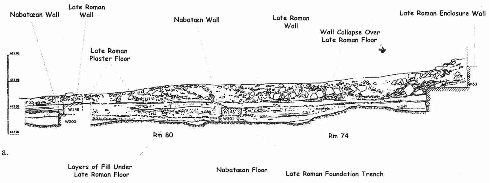 Fig. 1.71a
Cross section of the principia in the army camp at Oboda
Erickson-Gini (2010) - Fig. 1.79 Photo and section of
Room 23 in Late Roman/Early Byzantine Quarter from Erickson-Gini (2010)
 Fig. 1.79
Room 23 in situ plaster on wall 55, and b. section drawing of the room
Erickson-Gini (2010)
- Fig. 1.71a Cross section of
the principia in the army camp from Erickson-Gini (2010)
Fig. 1.71a
Cross section of the principia in the army camp at Oboda
Erickson-Gini (2010) - Fig. 1.79 Photo and section of
Room 23 in Late Roman/Early Byzantine Quarter from Erickson-Gini (2010)
Fig. 1.79
Room 23 in situ plaster on wall 55, and b. section drawing of the room
Erickson-Gini (2010)
- Fig. 2 Warped external wall
in Area A from Erickson-Gini (2022)
 Fig. 2
Area A, the warped external western wall (W1), looking southeast.
Erickson-Gini (2022) - Fig. 3 arch springer along
the northern interior of Wall W1 in Area A from Erickson-Gini (2022)
 Fig. 3
Area A, the arch springer along the northern interior of W1, looking northwest
Erickson-Gini (2022) - Fig. 4 remains of earlier
wall over which Wall W1 was constructed in Area A from Erickson-Gini (2022)
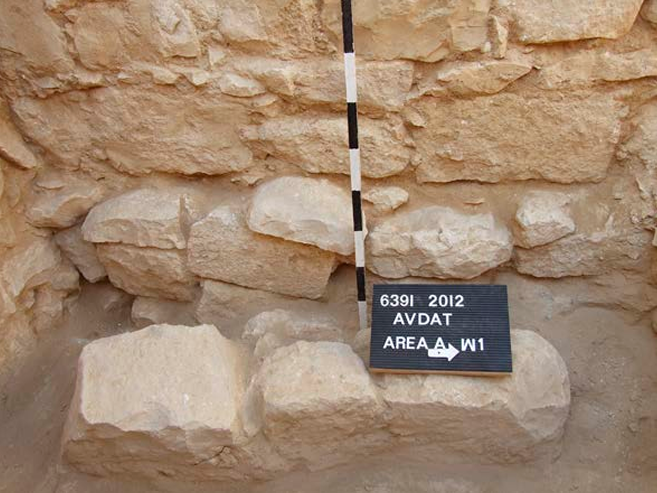 Fig. 4
Area A, remains of earlier wall over which W1 was constructed and the line of stones (W5), looking west
Erickson-Gini (2022) - Fig. 5 southern wall (W3)
and the foundation of original western Wall W1 on the right in Area A from Erickson-Gini (2022)
 Fig. 5
Area A, the southern wall (W3) and the foundation of original western W1 on the right, looking south
Erickson-Gini (2022) - Fig. 6 repairs in the
northern wall (W2) in Area A from Erickson-Gini (2022)
 Fig. 6
Area A, repairs in the northern wall (W2), looking north.
Erickson-Gini (2022) - Fig. 8 Collapsed arches
and ceiling slabs in Room 1 of Area B from Erickson-Gini (2022)
 Fig. 8
Area B, collapsed arches and ceiling slabs in Room 1, looking west.
Erickson-Gini (2022) - Fig. 9 Rotated Blocks in
Room 1 of Area B from Erickson-Gini (2022)
 Fig. 9
Area B, signs of rotation in the arch springer along W1 in Room 1.
Erickson-Gini (2022) - Fig. 10 Arch Stone from
Room 1 in Area B from Erickson-Gini (2022)
 Fig. 10
Area B, arch stone with incised, red-painted frame from the collapse in Room 1.
Erickson-Gini (2022) - Fig. 11 Arch Stone from
Room 1 in Area B from Erickson-Gini (2022)
 Fig. 11
Area B, arch stone with incised, red-painted lines and frame from the collapse in Room 1.
Erickson-Gini (2022) - Fig. 15 Remains of pantry
in L2/01 of Room 2 in Area B from Erickson-Gini (2022)
 Fig. 15
Area B, remains of pantry in L2/01, looking southeast.
Erickson-Gini (2022) - Fig. 16 Collapsed bedrock
shelf fronting cave above Dipinti Cave from Erickson-Gini (2022)
 Fig. 16
Area D, collapsed bedrock shelf fronting the cave above the Dipinti Cave, looking north.
Erickson-Gini (2022) - Fig. 18 probe in front of
Dipinti Wall in Area D from Erickson-Gini (2022)
 Fig. 18
Area D, eastern extension of probe in front of Dipinti Wall, looking east toward W2.
Erickson-Gini (2022) - Fig. 19 blocked entrance of
Dipinti Cave in Area D from Erickson-Gini (2022)
 Fig. 19
Area D, blocked entrance of Dipinti Cave, looking north
Erickson-Gini (2022) - Fig. 1.78a Fallen arch
attributed to 363 CE earthquake in Room 4 Phase 3 of Late Roman/Early Byzantine Quarter from Erickson-Gini (2010)
 Fig. 1.78a
Fallen arch under the floor of Room 4, Phase 3, sublevel, 363 CE
Erickson-Gini (2010) - Fig. 1.78b Crushed Pottery
attributed to 5th c. CE earthquake in Room 7 Phase 3 of Late Roman/Early Byzantine Quarter from Erickson-Gini (2010)
 Fig. 1.78b
Vessels crushed under the collapse of Room 7, phase 3, early fifth c. CE
Erickson-Gini (2010) - Fig. 1.80a Fallen lintel on
the floor of Room 22 of Late Roman/Early Byzantine Quarter from Erickson-Gini (2010)
 Fig. 1.80a
Fallen lintel on the floor of Room 22
Erickson-Gini (2010) - Fig. 1.80b In situ brazier
made from a “Gaza” wine jar on the floor of Room 22 of Late Roman/Early Byzantine Quarter from Erickson-Gini (2010)
 Fig. 1.80b
In situ brazier made from a “Gaza” wine jar on same floor [Room 22]
Erickson-Gini (2010) - Photo 6 So-called Potter's
Workshop and Khan from Negev (1997:5)
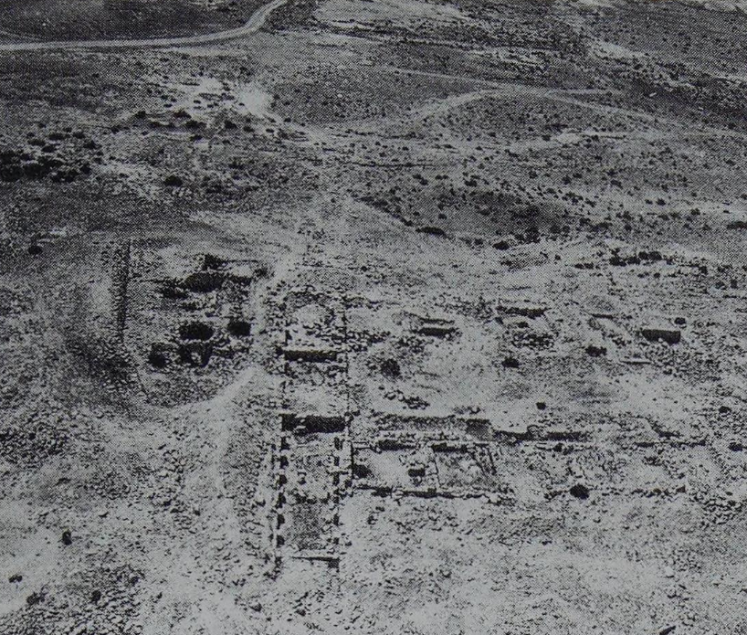 Photo 6
The khan, potter's workshop
Negev (1997:5) - Photo of so-called Potter's
Workshop (?) by Jefferson Williams
 So-called Potter's workshop at Avdat/Oboda
(JW: or so I thought at the time - I could be wrong)
Photo by Jefferson Williams
- Fig. 1 Aerial Overview of
Avdat from Zion et al (2022)
Figure 1
Avdat, looking east
- Army Camp from Roman Period
- Residential District
- Acropolis
- Cave City Avdat - W slope
- Cave City Avdat - E slope
- Orchards and Winepresses ?
- Orchards
- Orchards
- Orchards
- "Cave of the Saints"
(Photogrammetry: Yaakov Shmidov).
Zion et al (2022) - Late Roman/early Byzantine
quarter occupational phases and room from Stern et al (2008)
Late Roman/early Byzantine quarter occupational phases and rooms
Stern et al (2008)
- Fig. 1 Excavation Areas A, B,
and D from Erickson-Gini (2022)
Fig. 1
The excavation areas
Erickson-Gini (2022) - Plan 3 plan of dipinti
Cave in Area D from Erickson-Gini (2022)
Plan 3
Area D, plan of the Dipinti Cave.
Erickson-Gini (2022)
- Fig. 1 Excavation Areas A, B,
and D from Erickson-Gini (2022)
Fig. 1
The excavation areas
Erickson-Gini (2022) - Plan 3 plan of dipinti
Cave in Area D from Erickson-Gini (2022)
Plan 3
Area D, plan of the Dipinti Cave.
Erickson-Gini (2022)
- Fig. 1 Excavation Areas A, B,
and D from Erickson-Gini (2022)
Fig. 1
The excavation areas
Erickson-Gini (2022) - Plan 1 Area A from
Erickson-Gini (2022)
Plan 1
Area A
Erickson-Gini (2022) - Plan 2 Area B, plan
and sections from Erickson-Gini (2022)
Plan 2
Area B, plan and sections
Erickson-Gini (2022)
- Fig. 1 Excavation Areas A, B,
and D from Erickson-Gini (2022)
Fig. 1
The excavation areas
Erickson-Gini (2022) - Plan 1 Area A from
Erickson-Gini (2022)
Plan 1
Area A
Erickson-Gini (2022) - Plan 2 Area B, plan
and sections from Erickson-Gini (2022)
Plan 2
Area B, plan and sections
Erickson-Gini (2022)
- Fig. 2 Warped external wall
in Area A from Erickson-Gini (2022)
Fig. 2
Area A, the warped external western wall (W1), looking southeast.
Erickson-Gini (2022) - Fig. 8 Collapsed arches
and ceiling slabs in Room 1 of Area B from Erickson-Gini (2022)
Fig. 8
Area B, collapsed arches and ceiling slabs in Room 1, looking west.
Erickson-Gini (2022) - Fig. 9 Rotated Blocks in
Room 1 of Area B from Erickson-Gini (2022)
Fig. 9
Area B, signs of rotation in the arch springer along W1 in Room 1.
Erickson-Gini (2022) - Fig. 10 Arch Stone from
Room 1 in Area B from Erickson-Gini (2022)
Fig. 10
Area B, arch stone with incised, red-painted frame from the collapse in Room 1.
Erickson-Gini (2022) - Fig. 11 Arch Stone from
Room 1 in Area B from Erickson-Gini (2022)
Fig. 11
Area B, arch stone with incised, red-painted lines and frame from the collapse in Room 1.
Erickson-Gini (2022) - Fig. 16 Collapsed bedrock
shelf fronting cave above dipinti Cave from Erickson-Gini (2022)
Fig. 16
Area D, collapsed bedrock shelf fronting the cave above the Dipinti Cave, looking north.
Erickson-Gini (2022)
- Fig. 2 - Aerial view of the
southern slope at Avdat from Bucking (2022)
 Figure 2
Aerial view of the southern slope at Avdat after the 2018 season, with inset showing final excavation of the southern compound after 2019 season
(photograph by E. Alajem; inset by S. Bucking)
Bucking et al (2022) - Fig. 4 - South-western section
chronology from Bucking (2022)
 Figure 4
South-western section chronology in context
(photographs by T. Erickson-Gini)
Bucking et al (2022) - Fig. 5 - from
Bucking (2022)
 Figure 5
- Western section sampling
- northern section sampling
- reference photo for samplings, showing passageway to the cave after clearing of the northern section
(photographs by D. Fuks)
Bucking et al (2022)
- Fig. 1 Excavation Areas A, B,
and D from Erickson-Gini (2022)
Fig. 1
The excavation areas
Erickson-Gini (2022) - Plan 3 plan of dipinti
Cave in Area D from Erickson-Gini (2022)
Plan 3
Area D, plan of the Dipinti Cave.
Erickson-Gini (2022)
- Fig. 1 Excavation Areas A, B,
and D from Erickson-Gini (2022)
Fig. 1
The excavation areas
Erickson-Gini (2022) - Plan 3 plan of dipinti
Cave in Area D from Erickson-Gini (2022)
Plan 3
Area D, plan of the Dipinti Cave.
Erickson-Gini (2022)
- Fig. 1 Excavation Areas A, B,
and D from Erickson-Gini (2022)
Fig. 1
The excavation areas
Erickson-Gini (2022) - Plan 1 Area A from
Erickson-Gini (2022)
Plan 1
Area A
Erickson-Gini (2022) - Plan 2 Area B, plan
and sections from Erickson-Gini (2022)
Plan 2
Area B, plan and sections
Erickson-Gini (2022)
- Fig. 2 Warped external wall
in Area A from Erickson-Gini (2022)
Fig. 2
Area A, the warped external western wall (W1), looking southeast.
Erickson-Gini (2022) - Fig. 8 Collapsed arches
and ceiling slabs in Room 1 of Area B from Erickson-Gini (2022)
Fig. 8
Area B, collapsed arches and ceiling slabs in Room 1, looking west.
Erickson-Gini (2022) - Fig. 9 Rotated Blocks in
Room 1 of Area B from Erickson-Gini (2022)
Fig. 9
Area B, signs of rotation in the arch springer along W1 in Room 1.
Erickson-Gini (2022) - Fig. 10 Arch Stone from
Room 1 in Area B from Erickson-Gini (2022)
Fig. 10
Area B, arch stone with incised, red-painted frame from the collapse in Room 1.
Erickson-Gini (2022) - Fig. 11 Arch Stone from
Room 1 in Area B from Erickson-Gini (2022)
Fig. 11
Area B, arch stone with incised, red-painted lines and frame from the collapse in Room 1.
Erickson-Gini (2022) - Fig. 16 Collapsed bedrock
shelf fronting cave above dipinti Cave from Erickson-Gini (2022)
Fig. 16
Area D, collapsed bedrock shelf fronting the cave above the Dipinti Cave, looking north.
Erickson-Gini (2022)
| Effect | Location | Image(s) | Comments |
|---|---|---|---|
| Collapsed Walls (based on rebuilding evidence) |
residential structures from the earliest phase of the Nabataean settlement
east of the late Roman residential quarter
Oboda: general plan of the site and military camp. Stern et al (1993) |
|
| Effect | Location | Image(s) | Comments |
|---|---|---|---|
| Collapsed Vaults | Caves in the slopes adjacent to the Avdat Acropolis Figure 4
Location of the caves in the northern part of Avdat, looking east Photo: Yaakov Shmidov, preparation: Ofer Sion Zion et al (2022)  Figure 5
Location of the caves in the southern part of Avdat Photo: Yaakov Shmidov, preparation: Ofer Sion Zion et al (2022) |
|
|
| Collapsed Walls | Caves in the slopes adjacent to the Avdat Acropolis
Figure 4 Location of the caves in the northern part of Avdat, looking east Photo: Yaakov Shmidov, preparation: Ofer Sion Zion et al (2022)
Figure 5Location of the caves in the southern part of Avdat Photo: Yaakov Shmidov, preparation: Ofer Sion Zion et al (2022) |
|
|
| Collapsed Walls | Room 7 of Late Roman/Early Byzantine quarter
Late Roman/early Byzantine quarter occupational phases and rooms Stern et al (2008)
Fig. 1.77Oboda Late Roman / Early Byzantine Quarter, 1999-2000 excavations Erickson-Gini (2010) |
|
|
| Displaced walls surmised from blocked doorways (the blockage shoring up weakened walls) | Rooms 4, 7?, 17 of Late Roman/Early Byzantine quarter
Late Roman/early Byzantine quarter occupational phases and rooms Stern et al (2008)
Fig. 1.77Oboda Late Roman / Early Byzantine Quarter, 1999-2000 excavations Erickson-Gini (2010) |
|
|
| Collapsed Arch | Room 4 of Late Roman/Early Byzantine quarter
Late Roman/early Byzantine quarter occupational phases and rooms Stern et al (2008)
Fig. 1.77Oboda Late Roman / Early Byzantine Quarter, 1999-2000 excavations Erickson-Gini (2010) |
Fig. 1.78a Fallen arch under the floor of Room 4, Phase 3, sublevel, 363 CE Erickson-Gini (2010) |
|
| Effect | Event "Previous" or 7th century |
Location | Image(s) | Comments |
|---|---|---|---|---|
| TREND DISCORDANCE OF FIRST LOWER ROWS OF MASONRY WITH UPPER WALL FRAGMENTS, AND TREND DEVIATION FROM PERPENDICULAR OF WALLS JOINING EACH OTHER | "Previous" | Room 10 of Court in South Quarter Figure 3
Detailed plan of one court in the South Quarter (after Fabian, 1997, with modifications). Area of the court is shaded in Figure 2.
Korjenkov and Mazor (1999) |
5
 Figure 5
Counterclockwise rotation of whole western wall of room No. 10 of the court (see Figure 4). Its former position - preserved fundamental row - is shown by pointers. Korjenkov and Mazor (1999) |
Strange discordance of trends of first lower rows of masonry (usually one or two rows) and upper wall fragments is visible in some parts of Avdat. For example, there is counterclockwise rotation of the whole NW wall of room No. 10 of the court (see, Figure 3). Horizontal displacement was 45 cm. During rotation around the vertical axis the NW wall was not collapsed and townsmen, who settled there after the 363 A.D. shock, used the rotated wall for rebuilding (Fabian 1996, 1997). The original trend of the wall was 50°, preserved first and second lower rows testify about that building (Figure 5). Modern trend azimuth of rotated wall is 41°.- Korjenkov and Mazor (1999) |
| SHIFTING OF UPPER PRESERVED FRAGMENTS OF WALLS AS COMPARED WITH LOWER ROWS OF STONES | "Previous" | Room 8 of Court in South Quarter
Figure 3 Detailed plan of one court in the South Quarter (after Fabian, 1997, with modifications). Area of the court is shaded in Figure 2.
Korjenkov and Mazor (1999) |
6
 Figure 6
Displacement to WNW of wall fragment of room No. 8 of the court (see Figure 3). Its former position is shown by pointers. Korjenkov and Mazor (1999) |
The shift of the building elements without rotation may be used in a similar manner to wall inclination or block collapse. The upper element of a construction is shifted toward or away from an epicenter due to inertia. In the Avdat such a displacement, of 80 cm, can be observed for the upper fragment of the NW wall of room No. 8 of the court (see, Figure 3) in a NW direction (Figure 6). Its former position (trend azimuth is 41°) is marked by one stone row of 20 cm height. The width of the shifted wall fragment is 70 cm, length is 165 cm, height of preserved fragment is 55-60 cm, its trend azimuth is 45°.- Korjenkov and Mazor (1999) |
| NONCOINCIDENCE OF LOWER STONE ROWS WITH UPPER BUILDING STRUCTURES | "Previous" | N yard of bath-house | 7a
 Figure 7a
Noncoincidence of lower most stone rows and upper fragments of wall in the northern yard of bath-house situated near Avdat hill foot. (a) View to northern yard corner Korjenkov and Mazor (1999) 7b  Figure 7b
Noncoincidence of lower most stone rows and upper fragments of wall in the northern yard of bath-house situated near Avdat hill foot.>br> (b) NW external wall of yard, lower most stone row is continuing to NW "without reason" (field notebook is on it). The bath-house is on the background. Korjenkov and Mazor (1999) |
Additional indirect evidence of possible seismic activity in the studied territory is non-coincidence of lower stone rows with upper building structures. Such patterns occurred when a building was partly destroyed during an earthquake, but ancient people decided not to restore it. They removed still standing preserved fragments of the destroyed building and smoothed out the piles of rubble. They built a new building on the site of the old one. Later, during recent archeological excavations, researchers discovered strange non-coincidence of lower stone rows with upper building structures (Fabian, 1996, 1997).- Korjenkov and Mazor (1999) |
| SUPPORT-WALLS | "Previous" | Southern Church
Figure 3 Avdat Settlement Plan Zion et al (2022) |
8
 Figure 8
Support-wall was built for support of eastern corner of Southern Church. Korjenkov and Mazor (1999) |
Indirect evidence of more old shocks are special support-walls which were built solely for this purpose. One such wall was built to support the eastern corner of the Southern Church (P. Fabian, 1994, personal communication). The wall which needed support had an ENE trend (Figure 8). One more support-wall was built to support the external wall (with NE strike) of the South Quarter of the town, opposite the eastern corner of the Fort, later it was dismantled by archeologists during excavation (P. Fabian, personal communication, 1996). This building of supporting walls for city walls of the same trend is not isolated. Apparently, during the Roman earthquake these city walls were slightly tilted, but they were not collapsed. Ancient people built those support-walls specifically to prevent them from possible future collapse (Fabian, 1996, 1997).- Korjenkov and Mazor (1999) |
| CAVE DESTRUCTIONS | "Previous" | Caves
Figure 4 Location of the caves in the northern part of Avdat, looking east Photo: Yaakov Shmidov, preparation: Ofer Sion Zion et al (2022)
Figure 5Location of the caves in the southern part of Avdat Photo: Yaakov Shmidov, preparation: Ofer Sion Zion et al (2022) |
As stated above, on the slope of Avdat hill there are many caves which were inhabited for living during Nabatean—Byzantine times. However, below the caves there are huge piles of rubble, which consist of debris from Avdat hill's rocks and from remains of domestic objects (pieces of Nabatean earthenware vessels, for example - T. Gini, personal communication, 1996). This fact also indicates a possible earthquake in 363 A.D. during which the collapse of inhabited caves took place. After that event ancient people cleaned out the caves and used them for living in for the second time. However, some of the caves were not cleaned after the 363 A.D. shock.- Korjenkov and Mazor (1999) |
| Effect | Event "Previous" or 7th century |
Location | Image(s) | Comments |
|---|---|---|---|---|
| JOINTS AS AN INDICATION OF THE SEISMIC NATURE OF THE DESTRUCTIONS | 7th century | WSW external wall of the Northern Church
Figure 3 Avdat Settlement Plan Zion et al (2022) |
4
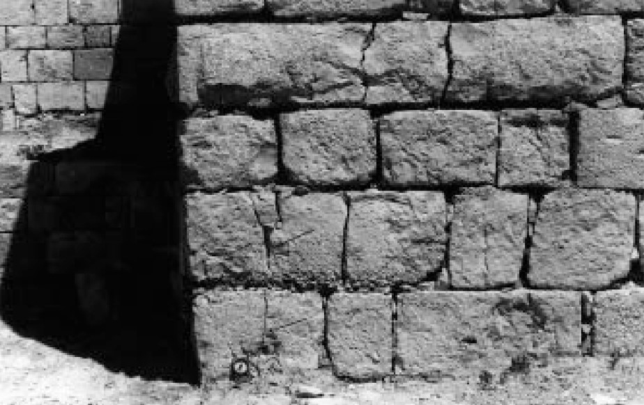 Figure 4
Joints in western end of NNW wall of Northern Church (trend azimuth of a wall 151°). One joint on left corner crosses two blocks. Width of opening is to 1.5 cm. Trend azimuth of joint in upper block is 57-70°, in lower one is 35°. Korjenkov and Mazor (1999) |
Joints are mode 1 (dilatation) fractures developed as a result of extension (Engelder and Fisher. 1996). Joints confined to stone breaks often appear in old buildings. Interpretation of such joints is somewhat ambiguous: they could be erected tectonically, they could also be the result of weathering, i.e., repeated heating and cooling events. In contrast, joints passing through two or more adjacent blocks (through-going joints) could be formed only under high strains. Such joints require the application of tremendous amounts of energy to overcome the stress shadows, appearing along free surfaces at the block margins (Fisher et al., 1995: Engelder, and Fisher, 1996; Becker and Gross, 1996) and therefore cannot be related to the weathering process.- Korjenkov and Mazor (1999) |
| INCLINATION OF BUILDING AND CONSTRUCTION ELEMENTS | mostly 7th century ? | various locations | 9
 Figure 9
Example of inclination and collapse of walls of the Byzantine Avdat, inclination of the lower part of a courtyard wall and collapse of the upper part, both in the same direction. Korjenkov and Mazor (1999) 10  Figure 10
Angle of inclination of walls versus wall trends, Avdat ruins. Walls trending 40-60° have no preferential direction of inclination. In contrast, walls trending 130-140° are systematically inclined to the south. Korjenkov and Mazor (1999) |
As in strong earthquakes throughout the world, a large number of structural elements were found to be preferentially inclined (Richter, 1958; Cloud and Scott, 1969; Bolt, 1978; Polyakov, 1978; Omuraliev et al., 1993a and others). A similar destruction was found in the ancient city of Avdat: forty one cases of preferentially inclined walls (Figures 9 and 10) and inclination of single stones within walls can be seen there. As seen in Figure 5, walls trending SE 130°-140° are systematically inclined to the SW. In contrast walls trending NE 40°-60° are inclined to NW and SE with no preferential direction. This observation seems to indicate that the seismic shock arrived along the NE—SW direction: the walls oriented roughly normal to the seismic wave direction were systematically collapsed or inclined, whereas walls oriented parallel to the seismic waves lost support, were tilted and collapsed randomly.- Korjenkov and Mazor (1999) |
| COLLAPSE FEATURES | 7th century ? | Agricultural Fences | 11a
 Figure 11a
Ruins of Byzantine agricultural fences remained on the top of Avdat hill. Korjenkov and Mazor (1999) 11b  Figure 11b
Ruins of Byzantine agricultural fences remained near the foot of Avdat hill. Korjenkov and Mazor (1999) 12  Figure 12
Direction of preferred collapse, measured at Avdat, as a function of wall directions. A single group of collapse directions has been observed. Korjenkov and Mazor (1999) 13  Figure 13
Drag because of wall collapse in Avdat (a) model of the drag (b) diagram of drag cases in Avdat archaeological site. Korjenkov and Mazor (1999) |
Numerous ruins of agricultural fences remained on the top (Figure 11(a)) and near the foot of the Avdat hill (Figure 11(b)). The fences trending about EW reveal a clear systematic picture of the collapse: the lower part of the wall is intact (easily seen from its northern side), whereas the upper part of the fences fell southward (see Figure 11). Azimuth of preferred collapsed features are plotted in Figure 12 versus wall trend. One group of walls trending SE 90°-140° reveals collapse toward SW 180°-240°, whereas walls oriented in other directions fell on both sides of the original wall position, they did not show a systematic pattern of the collapse, and so they were not shown on the graph. This observation indicates that the direction of seismic wave propagation was roughly perpendicular to the SE-trending walls.- Korjenkov and Mazor (1999) |
| ROTATION OF BUILDING ELEMENTS | 7th century ? | Avdat Tower and wall in the southern quarter
Figure 3 Avdat Settlement Plan Zion et al (2022) |
13
Figure 13 Drag because of wall collapse in Avdat (a) model of the drag (b) diagram of drag cases in Avdat archaeological site. Korjenkov and Mazor (1999) 14a  Figure 14a
Counterclockwise rotation of whole fragment of the wall in Southern Quarter, Avdat Korjenkov and Mazor (1999) 14b  Figure 14b
Clockwise rotation in SW wall of the Avdat Tower. Korjenkov and Mazor (1999) 15  Figure 15
Rotation of stones and walls in Avdat archaeological site. Korjenkov and Mazor (1999) |
Field study of the epicentral zones of the well-known strong earthquakes revealed that some building constructions or rock fragments were rotated clockwise, whereas others were rotated counterclockwise (Richter, 1958; Cloud and Scott, 1969; Bolt, 1978: Polyakov, 1978; Omuraliev et al., 1993b and others). Horizontal rotation of arch supports, separate blocks in arch supports and walls, or rotation of a large fragment of a wall with tens to hundreds of stones were measured in the ruins of Avdat town. Clockwise and counterclockwise patterns of rotation were observed. Some examples of the rotated elements are shown in Figure 14.- Korjenkov and Mazor (1999) |
|
7th century | Area A
Fig. 1 The excavation areas Erickson-Gini (2022)
Plan 1Area A Erickson-Gini (2022) |
Fig. 2
Fig. 2 Area A, the warped external western wall (W1), looking southeast. Erickson-Gini (2022) |
In a structure at the end of the main street of the residential Roman/Byzantine Quarter, the western half of a room was excavated (Plan 1; 2.5 × 5.0 m) to facilitate the reconstruction of its western wall (W1); its exterior had been warped by earthquake damage that occurred in the early seventh century CE (Fig. 2; see Negev 1997:2, Fig. 1). The walls survived to an impressive height: the western wall (W1) stood 10 courses high (2.3 m), the northern wall (W2), 14 courses (2.3 m), and the southern wall (W3), 15 courses (2.8 m). ... The walls apparently supported an upper floor. Inside the room, in the upper layer of the excavation trench, where stone ceiling slabs and arch stones were uncovered, was evidence of heavy earthquake collapse.- Erickson-Gini (2022) |
|
7th century | Area B Room 1
Fig. 1 The excavation areas Erickson-Gini (2022)
Plan 2Area B, plan and sections Erickson-Gini (2022) |
Fig. 8 Area B, collapsed arches and ceiling slabs in Room 1, looking west. Erickson-Gini (2022)
Fig. 9Area B, signs of rotation in the arch springer along W1 in Room 1. Erickson-Gini (2022) |
Collapsed arches and ceiling slabs were discovered throughout the room [1] (L1/00; Fig. 8) and the arch springer in W1 appears to have rotated slightly due to an earthquake (Fig. 9; Plan 2: Section 1–1).- Erickson-Gini (2022) |
|
7th century | Area B Room 2
Fig. 1 The excavation areas Erickson-Gini (2022)
Plan 2Area B, plan and sections Erickson-Gini (2022) |
Fig. 15 Area B, remains of pantry in L2/01, looking southeast. Erickson-Gini (2022) |
In the southeastern corner of the courtyard (L2/01), the collapsed remains of a small pantry room (Fig. 15) were uncovered, containing several broken ceramic vessels, mainly cooking wares, as well as a late form of a Gaza wine jar, parts of a late Byzantine glass bottle and part of a marble paten with faded decoration (see below). A collapsed baking oven (L4/00, L4/01; c. 1.5 × 2.0 m), revealed in the northwestern corner of the courtyard, opposite the stairs, and its roof, appear to have been supported by a small limestone arch discovered in a collapsed state. The oven was built into the corner of the courtyard and may have had an opening in the oven’s southern end. It is similar in plan to an oven of the early Byzantine period in Room 38 of the Roman/Byzantine Quarter (Erickson-Gini 2010:94). A nearly complete imported semi-fine-ware bowl was uncovered above the collapsed oven, and a large bagshaped storage jar lacking its rim was found sunk into the floor south of the oven. The presence of the oven and storage jars sunk into the earthen floor of the courtyard indicate that the room served as a bakery where grain was stored for grinding.- Erickson-Gini (2022) |
|
7th century | Dipinti Cave in Area D
Fig. 1 The excavation areas Erickson-Gini (2022)
Plan 3Area D, plan of the Dipinti Cave. Erickson-Gini (2022) |
Fig. 16 Area D, collapsed bedrock shelf fronting the cave above the Dipinti Cave, looking north. Erickson-Gini (2022)
Fig. 18Area D, eastern extension of probe in front of Dipinti Wall, looking east toward W2. Erickson-Gini (2022) |
Area D was excavated on the southern slope of the acropolis, c. 15 m north of the modern access road. Evidence of massive earthquake debris was revealed, similar to that discovered on the western and northern slopes of the acropolis, where bedrock shelves above the front rooms of man-made caves had collapsed (Fig. 16). ... A probe 0.7 m wide was excavated along the exterior of the dipinti Wall, in an area covered with heavy collapsed debris from the bedrock shelf of the terrace above the cave (Plan 3; Fig. 18).- Erickson-Gini (2022) |
| Effect | Event "Previous" or 7th century |
Location | Image(s) | Comments |
|---|---|---|---|---|
| JOINTS AS AN INDICATION OF THE SEISMIC NATURE OF THE DESTRUCTIONS | 7th century | Northern Church | 4
Figure 4 Joints in western end of NNW wall of Northern Church (trend azimuth of a wall 151°). One joint on left corner crosses two blocks. Width of opening is to 1.5 cm. Trend azimuth of joint in upper block is 57-70°, in lower one is 35°. Korjenkov and Mazor (1999) |
Joints are mode 1 (dilatation) fractures developed as a result of extension (Engelder and Fisher. 1996). Joints confined to stone breaks often appear in old buildings. Interpretation of such joints is somewhat ambiguous: they could be erected tectonically, they could also be the result of weathering, i.e., repeated heating and cooling events. In contrast, joints passing through two or more adjacent blocks (through-going joints) could be formed only under high strains. Such joints require the application of tremendous amounts of energy to overcome the stress shadows, appearing along free surfaces at the block margins (Fisher et al., 1995: Engelder, and Fisher, 1996; Becker and Gross, 1996) and therefore cannot be related to the weathering process. |
| TREND DISCORDANCE OF FIRST LOWER ROWS OF MASONRY WITH UPPER WALL FRAGMENTS, AND TREND DEVIATION FROM PERPENDICULAR OF WALLS JOINING EACH OTHER | "Previous" | Room 10 of Court in South Quarter | 3
Figure 3 Detailed plan of one court in the South Quarter (after Fabian, 1997, with modifications). Area of the court is shaded in Figure 2.
Korjenkov and Mazor (1999) 5
Figure 5Counterclockwise rotation of whole western wall of room No. 10 of the court (see Figure 4). Its former position - preserved fundamental row - is shown by pointers. Korjenkov and Mazor (1999) |
Strange discordance of trends of first lower rows of masonry (usually one or two rows) and upper wall fragments is visible in some parts of Avdat. For example, there is counterclockwise rotation of the whole NW wall of room No. 10 of the court (see, Figure 3). Horizontal displacement was 45 cm. During rotation around the vertical axis the NW wall was not collapsed and townsmen, who settled there after the 363 A.D. shock, used the rotated wall for rebuilding (Fabian 1996, 1997). The original trend of the wall was 50°, preserved first and second lower rows testify about that building (Figure 5). Modern trend azimuth of rotated wall is 41°. |
| SHIFTING OF UPPER PRESERVED FRAGMENTS OF WALLS AS COMPARED WITH LOWER ROWS OF STONES | "Previous" | Room 8 of Court in South Quarter | 3
Figure 3 Detailed plan of one court in the South Quarter (after Fabian, 1997, with modifications). Area of the court is shaded in Figure 2.
Korjenkov and Mazor (1999) 6
Figure 6Displacement to WNW of wall fragment of room No. 8 of the court (see Figure 3). Its former position is shown by pointers. Korjenkov and Mazor (1999) |
The shift of the building elements without rotation may be used in a similar manner to wall inclination or block collapse. The upper element of a construction is shifted toward or away from an epicenter due to inertia. In the Avdat such a displacement, of 80 cm, can be observed for the upper fragment of the NW wall of room No. 8 of the court (see, Figure 3) in a NW direction (Figure 6). Its former position (trend azimuth is 41°) is marked by one stone row of 20 cm height. The width of the shifted wall fragment is 70 cm, length is 165 cm, height of preserved fragment is 55-60 cm, its trend azimuth is 45°. |
| NONCOINCIDENCE OF LOWER STONE ROWS WITH UPPER BUILDING STRUCTURES | "Previous" | N yard of bath-house | 7a
Figure 7a Noncoincidence of lower most stone rows and upper fragments of wall in the northern yard of bath-house situated near Avdat hill foot. (a) View to northern yard corner Korjenkov and Mazor (1999) 7b
Figure 7bNoncoincidence of lower most stone rows and upper fragments of wall in the northern yard of bath-house situated near Avdat hill foot.>br> (b) NW external wall of yard, lower most stone row is continuing to NW "without reason" (field notebook is on it). The bath-house is on the background. Korjenkov and Mazor (1999) |
Additional indirect evidence of possible seismic activity in the studied territory is non-coincidence of lower stone rows with upper building structures. Such patterns occurred when a building was partly destroyed during an earthquake, but ancient people decided not to restore it. They removed still standing preserved fragments of the destroyed building and smoothed out the piles of rubble. They built a new building on the site of the old one. Later, during recent archeological excavations, researchers discovered strange non-coincidence of lower stone rows with upper building structures (Fabian, 1996, 1997). |
| SUPPORT-WALLS | "Previous" | Southern Church | 8
Figure 8 Support-wall was built for support of eastern corner of Southern Church. Korjenkov and Mazor (1999) |
Indirect evidence of more old shocks are special support-walls which were built solely for this purpose. One such wall was built to support the eastern corner of the Southern Church (P. Fabian, 1994, personal communication). The wall which needed support had an ENE trend (Figure 8). One more support-wall was built to support the external wall (with NE strike) of the South Quarter of the town, opposite the eastern corner of the Fort, later it was dismantled by archeologists during excavation (P. Fabian, personal communication, 1996). This building of supporting walls for city walls of the same trend is not isolated. Apparently, during the Roman earthquake these city walls were slightly tilted, but they were not collapsed. Ancient people built those support-walls specifically to prevent them from possible future collapse (Fabian, 1996, 1997). |
| CAVE DESTRUCTIONS | "Previous" | Caves | As stated above, on the slope of Avdat hill there are many caves which were inhabited for living during Nabatean—Byzantine times. However, below the caves there are huge piles of rubble, which consist of debris from Avdat hill's rocks and from remains of domestic objects (pieces of Nabatean earthenware vessels, for example - T. Gini, personal communication, 1996). This fact also indicates a possible earthquake in 363 A.D. during which the collapse of inhabited caves took place. After that event ancient people cleaned out the caves and used them for living in for the second time. However, some of the caves were not cleaned after the 363 A.D. shock. |
|
| INCLINATION OF BUILDING AND CONSTRUCTION ELEMENTS | mostly 7th century ? | various locations | 9
Figure 9 Example of inclination and collapse of walls of the Byzantine Avdat, inclination of the lower part of a courtyard wall and collapse of the upper part, both in the same direction. Korjenkov and Mazor (1999) 10
Figure 10Angle of inclination of walls versus wall trends, Avdat ruins. Walls trending 40-60° have no preferential direction of inclination. In contrast, walls trending 130-140° are systematically inclined to the south. Korjenkov and Mazor (1999) |
As in strong earthquakes throughout the world, a large number of structural elements were found to be preferentially inclined (Richter, 1958; Cloud and Scott, 1969; Bolt, 1978; Polyakov, 1978; Omuraliev et al., 1993a and others). A similar destruction was found in the ancient city of Avdat: forty one cases of preferentially inclined walls (Figures 9 and 10) and inclination of single stones within walls can be seen there. As seen in Figure 5, walls trending SE 130°-140° are systematically inclined to the SW. In contrast walls trending NE 40°-60° are inclined to NW and SE with no preferential direction. This observation seems to indicate that the seismic shock arrived along the NE—SW direction: the walls oriented roughly normal to the seismic wave direction were systematically collapsed or inclined, whereas walls oriented parallel to the seismic waves lost support, were tilted and collapsed randomly. |
| COLLAPSE FEATURES | 7th century ? | Agricultural Fences | 11a
Figure 11a Ruins of Byzantine agricultural fences remained on the top of Avdat hill. Korjenkov and Mazor (1999) 11b
Figure 11bRuins of Byzantine agricultural fences remained near the foot of Avdat hill. Korjenkov and Mazor (1999) 12
Figure 12Direction of preferred collapse, measured at Avdat, as a function of wall directions. A single group of collapse directions has been observed. Korjenkov and Mazor (1999) 13
Figure 13Drag because of wall collapse in Avdat (a) model of the drag (b) diagram of drag cases in Avdat archaeological site. Korjenkov and Mazor (1999) |
Numerous ruins of agricultural fences remained on the top (Figure 11(a)) and near the foot of the Avdat hill (Figure 11(b)). The fences trending about EW reveal a clear systematic picture of the collapse: the lower part of the wall is intact (easily seen from its northern side), whereas the upper part of the fences fell southward (see Figure 11). Azimuth of preferred collapsed features are plotted in Figure 12 versus wall trend. One group of walls trending SE 90°-140° reveals collapse toward SW 180°-240°, whereas walls oriented in other directions fell on both sides of the original wall position, they did not show a systematic pattern of the collapse, and so they were not shown on the graph. This observation indicates that the direction of seismic wave propagation was roughly perpendicular to the SE-trending walls. |
| ROTATION OF BUILDING ELEMENTS | 7th century ? | various locations | 13
Figure 13 Drag because of wall collapse in Avdat (a) model of the drag (b) diagram of drag cases in Avdat archaeological site. Korjenkov and Mazor (1999) 14a
Figure 14aCounterclockwise rotation of whole fragment of the wall in Southern Quarter, Avdat Korjenkov and Mazor (1999) 14b
Figure 14bClockwise rotation in SW wall of the Avdat Tower. Korjenkov and Mazor (1999) 15
Figure 15Rotation of stones and walls in Avdat archaeological site. Korjenkov and Mazor (1999) |
Field study of the epicentral zones of the well-known strong earthquakes revealed that some building constructions or rock fragments were rotated clockwise, whereas others were rotated counterclockwise (Richter, 1958; Cloud and Scott, 1969; Bolt, 1978: Polyakov, 1978; Omuraliev et al., 1993b and others). Horizontal rotation of arch supports, separate blocks in arch supports and walls, or rotation of a large fragment of a wall with tens to hundreds of stones were measured in the ruins of Avdat town. Clockwise and counterclockwise patterns of rotation were observed. Some examples of the rotated elements are shown in Figure 14. |
Study of the destruction in the Avdat ruins reveals a systematic type of dislocation:
- Walls of buildings trending SE 120° revealed strong preferential collapse or inclination toward south, whereas walls trending NE 20°-50° tilted and fell without
a noticeable systematic pattern (see Figure 10
). A similar structure of collapse was observed for the ruins of agricultural fences (see Figure 12
Figure 10
Angle of inclination of walls versus wall trends, Avdat ruins. Walls trending 40-60° have no preferential direction of inclination. In contrast, walls trending 130-140° are systematically inclined to the south.
Korjenkov and Mazor (1999)). These observations indicate that the seismic shock arrived from the south in the case of a compressional wave, or from the north, if the wave causing the collapse was extensional. Thus, by this exercise the eastward and westward propagating seismic waves can be excluded.
Figure 12
Direction of preferred collapse, measured at Avdat, as a function of wall directions. A single group of collapse directions has been observed.
Korjenkov and Mazor (1999) - Most rotated blocks in the Avdat ruins are turned counterclockwise and they were found exclusively on NE-trending walls (see Figure 15
). The only case of clockwise rotation was found in a wall fragment with trend SE 140°. The fact of the appearance of rotated blocks, as described above, indicates push movements (compression wave approaching the buildings). Thus, the only possibility left is a compressional seismic wave coming from the south. Rotation itself involves shear stresses acting along the walls, thus the seismic wave must have arrived at some angle to the walls.
Figure 15
Rotation of stones and walls in Avdat archaeological site.
Korjenkov and Mazor (1999)
 Figure 16
Symmetric shape of a collapse cone due to earthquake-induced wall oscillations. Oscillation of the wall ends is attenuated by the support of the perpendicular walls, and maximal oscillation occurs at the center (a). This results in a cone-shaped collapse feature, with a collapse line oriented normal to the wall (b).
Korjenkov and Mazor (1999)
The preferred direction of collapse or inclination of building elements may be either toward an epicenter or away from it. If the damaged site is located in the quadrangle of compression strain (Figure 17
 Figure 17
Strain quadrangle diagram and direction of destruction. Dashed lines depict the direction of wave front propagation, and the circle represents a projection of an epicenter. Direction of inclination of damage features is towards the epicenter in the quadrangles of compression strain, and it is away from the epicenter in the quadrangles of extension strain.
Korjenkov and Mazor (1999)
 Figure 18
Identification of earthquake epicenter applying a collapse pattern. Lines of collapse, measured in the damaged area, applied to determine an epicenter:
(1) epicenter
(2) directions of collapse
(3) lines of collapse.
As the collapse occurs toward or outward the epicenter, the intersections of the collapse lines are scattered around the epicenter, that allows to depict it.
Korjenkov and Mazor (1999)
Shear stresses applied to an elongated element cause its rotation. The direction of rotation depends on two factors:
- orientation of principle stresses in a location and
- the orientation of the elongated element
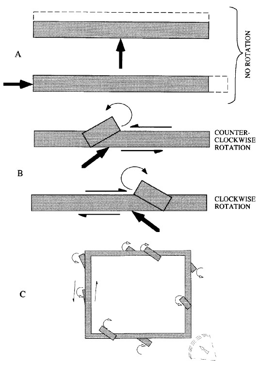 Figure 20
Rotation of building elements
(a) seismic rays normal to a wall cause no rotation
(b) seismic rays oblique to a wall result in a rotation of building elements
(c) a seismic shock arriving along the bisector to perpendicular walls of a building causes an opposing sense of rotation in these walls.
Korjenkov and Mazor (1999)
Figure 20Rotation of building elements
(a) seismic rays normal to a wall cause no rotation
(b) seismic rays oblique to a wall result in a rotation of building elements
(c) a seismic shock arriving along the bisector to perpendicular walls of a building causes an opposing sense of rotation in these walls.
Korjenkov and Mazor (1999)
Two mechanisms of rotation, caused by tectonic movements, are known in geology (Figure 21
 Figure 21
Simple shear producing an opposite sense of rotation
(a) book-shelf structures, or synthetically rotated blocks
(b) asymmetric pull-aparts, or antithetically rotated blocks. Adapted from Jordan (1991).
Korjenkov and Mazor (1999)
- book-shelf structures, or synthetically rotated blocks, and
- asymmetric pull-aparts, or antithetically rotated blocks (Jordan, 1991)
Figure 21Simple shear producing an opposite sense of rotation
(a) book-shelf structures, or synthetically rotated blocks
(b) asymmetric pull-aparts, or antithetically rotated blocks. Adapted from Jordan (1991).
Korjenkov and Mazor (1999)
Figure 20Rotation of building elements
(a) seismic rays normal to a wall cause no rotation
(b) seismic rays oblique to a wall result in a rotation of building elements
(c) a seismic shock arriving along the bisector to perpendicular walls of a building causes an opposing sense of rotation in these walls.
Korjenkov and Mazor (1999)
This discussion leads to an additional conclusion explaining the lack of oriented inclination and collapse features in an epicentral area (and additionally, to the assumption that the point seismic source is not valid in the epicentral zone): the shock wave moving from a hypocenter under a high angle to the surface, results in a lateral extension applied to constructions. This explains why in recent earthquakes (Acapulco, 1962; Scopje, 1963; Tashkent, 1966 and others) the areas above a hypo-center do not reveal systematic inclination and collapse patterns (Muto et al., 1963; Binder, 1965; Medvedev, 1966; The Scopje Earthquake of 26 July 1963, 1968; Mirzoev et al., 1969; Liquidation of Consequences of Tashkent Earthquake, 1972), whereas some distance away inclination and collapse have pronounced directional patterns (Figure 22
 Figure 22
Scheme of different patters of seismic destruction on different angles from hypocenter.
Korjenkov and Mazor (1999)
All said above is true for the features of destruction found in building constructions built on an isotropic massive foundation without a strong preferential orientation of the fabric in the basement rocks. In the studied case, Avdat was built directly on massive limestones. Thus, an input caused by rock anisotropy could be neglected. To avoid gravitational reasons for the city's destruction, the authors did not conduct the measurements on the slope of Avdat hill.
Avdat ruins have two perpendicular directions of walls (—NE 50° and —SE 140°), so the overall model can be represented as a single building (or room). To cause south-directed wall collapse by a compressional seismic wave, the shock should have come from south side. If the shock arrived exactly perpendicular to the NE-trending walls (i.e., from SW, Figure 23(a)
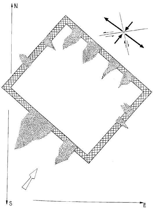 Figure 23a
Modelling of seismic wave's coming to Avdat town from SW (perpendicularly to walls with trend azimuth 130°-140°).
Korjenkov and Mazor (1999)
In contrast, maximal shear stresses would result if the seismic wave approached the buildings along a bisector line between the walls (Figure 23(b)
 Figure 23b
Modelling of seismic shock's coming to Avdat from SSE (under the angle 45° to walls of both directions).
Korjenkov and Mazor (1999)
In the case of Avdat the only NE-trending walls revealed oriented collapse and inclinations, and SE-trending walls demonstrate systematic counterclockwise rotations. Such a situation is possible if the compressional wave came from SSW (Figure 23(c)
 Figure 23c
Modelling of seismic wave's coming to Avdat town from SSW.
Korjenkov and Mazor (1999)
Thus, the epicenter was located somewhere SSW from the Avdat settlement, and the scale of destruction indicates that the epicenter was situated 15 km south of Avdat, probably in the area of the Nafha Fault zone. The force (seismic intensity) of a shock resulting in the destruction of buildings was determined using the scale of earthquake intensity MSK-64. Buildings in Avdat town according to this scale are classed as B type - buildings from natural hewed stones. Quantitative characteristics of destruction: most buildings were destroyed (more then 75%). According to the degree of destruction Avdat town is classified as fourth degree:
- through cracks and breaks in the walls
- collapse of building parts
- breaking of connections between separate parts of buildings
- collapse of internal walls and walls of framework filling
...
The destruction was caused by a compressional seismic wave and the epicenter was located SSW of Avdat somewhere in central Negev. The degree of town destruction during the historical earthquake according to Seismic Intensity Scale MSK-64 was IX-X.
-
Earthquake Archeological Effects chart
of Rodríguez-Pascua et al (2013: 221-224)
 Earthquake Archeological Effects (EAE)
Rodríguez-Pascua et al (2013: 221-224)
| Effect | Location | Image(s) | Comments | Intensity |
|---|---|---|---|---|
| Collapsed Walls (based on rebuilding evidence) |
residential structures from the earliest phase of the Nabataean settlement
east of the late Roman residential quarter
Oboda: general plan of the site and military camp. Stern et al (1993) |
|
VIII + |
-
Earthquake Archeological Effects chart
of Rodríguez-Pascua et al (2013: 221-224)
Earthquake Archeological Effects (EAE)
Rodríguez-Pascua et al (2013: 221-224)
| Effect | Location | Image(s) | Comments | Intensity |
|---|---|---|---|---|
| Collapsed Vaults | Caves in the slopes adjacent to the Avdat Acropolis
Figure 4 Location of the caves in the northern part of Avdat, looking east Photo: Yaakov Shmidov, preparation: Ofer Sion Zion et al (2022)
Figure 5Location of the caves in the southern part of Avdat Photo: Yaakov Shmidov, preparation: Ofer Sion Zion et al (2022) |
|
VIII + | |
| Collapsed Walls | Caves in the slopes adjacent to the Avdat Acropolis
Figure 4 Location of the caves in the northern part of Avdat, looking east Photo: Yaakov Shmidov, preparation: Ofer Sion Zion et al (2022)
Figure 5Location of the caves in the southern part of Avdat Photo: Yaakov Shmidov, preparation: Ofer Sion Zion et al (2022) |
|
VIII+ | |
| Collapsed Walls | Room 7 of Late Roman/Early Byzantine quarter
Late Roman/early Byzantine quarter occupational phases and rooms Stern et al (2008)
Fig. 1.77Oboda Late Roman / Early Byzantine Quarter, 1999-2000 excavations Erickson-Gini (2010) |
|
VIII+ | |
| Displaced walls surmised from blocked doorways (the blockage shoring up weakened walls) | Rooms 4, 7?, 17 of Late Roman/Early Byzantine quarter
Late Roman/early Byzantine quarter occupational phases and rooms Stern et al (2008)
Fig. 1.77Oboda Late Roman / Early Byzantine Quarter, 1999-2000 excavations Erickson-Gini (2010) |
|
VII+ | |
| Collapsed Arch | Room 4 of Late Roman/Early Byzantine quarter
Late Roman/early Byzantine quarter occupational phases and rooms Stern et al (2008)
Fig. 1.77Oboda Late Roman / Early Byzantine Quarter, 1999-2000 excavations Erickson-Gini (2010) |
Fig. 1.78a Fallen arch under the floor of Room 4, Phase 3, sublevel, 363 CE Erickson-Gini (2010) |
|
VI+ |
-
Earthquake Archeological Effects chart
of Rodríguez-Pascua et al (2013: 221-224)
Earthquake Archeological Effects (EAE)
Rodríguez-Pascua et al (2013: 221-224)
| Effect | Event "Previous" or 7th century |
Location | Image(s) | Comments | Intensity |
|---|---|---|---|---|---|
| Displaced Walls - TREND DISCORDANCE OF FIRST LOWER ROWS OF MASONRY WITH UPPER WALL FRAGMENTS, AND TREND DEVIATION FROM PERPENDICULAR OF WALLS JOINING EACH OTHER | "Previous" | Room 10 of Court in South Quarter
Figure 3 Detailed plan of one court in the South Quarter (after Fabian, 1997, with modifications). Area of the court is shaded in Figure 2.
Korjenkov and Mazor (1999) |
5
Figure 5 Counterclockwise rotation of whole western wall of room No. 10 of the court (see Figure 4). Its former position - preserved fundamental row - is shown by pointers. Korjenkov and Mazor (1999) |
Strange discordance of trends of first lower rows of masonry (usually one or two rows) and upper wall fragments is visible in some parts of Avdat. For example, there is counterclockwise rotation of the whole NW wall of room No. 10 of the court (see, Figure 3). Horizontal displacement was 45 cm. During rotation around the vertical axis the NW wall was not collapsed and townsmen, who settled there after the 363 A.D. shock, used the rotated wall for rebuilding (Fabian 1996, 1997). The original trend of the wall was 50°, preserved first and second lower rows testify about that building (Figure 5). Modern trend azimuth of rotated wall is 41°.- Korjenkov and Mazor (1999) |
VII+ |
| Displaced walls - SHIFTING OF UPPER PRESERVED FRAGMENTS OF WALLS AS COMPARED WITH LOWER ROWS OF STONES | "Previous" | Room 8 of Court in South Quarter
Figure 3 Detailed plan of one court in the South Quarter (after Fabian, 1997, with modifications). Area of the court is shaded in Figure 2.
Korjenkov and Mazor (1999) |
6
Figure 6 Displacement to WNW of wall fragment of room No. 8 of the court (see Figure 3). Its former position is shown by pointers. Korjenkov and Mazor (1999) |
The shift of the building elements without rotation may be used in a similar manner to wall inclination or block collapse. The upper element of a construction is shifted toward or away from an epicenter due to inertia. In the Avdat such a displacement, of 80 cm, can be observed for the upper fragment of the NW wall of room No. 8 of the court (see, Figure 3) in a NW direction (Figure 6). Its former position (trend azimuth is 41°) is marked by one stone row of 20 cm height. The width of the shifted wall fragment is 70 cm, length is 165 cm, height of preserved fragment is 55-60 cm, its trend azimuth is 45°.- Korjenkov and Mazor (1999) |
VII+ |
| Displaced walls - NONCOINCIDENCE OF LOWER STONE ROWS WITH UPPER BUILDING STRUCTURES | "Previous" | N yard of bath-house | 7a
Figure 7a Noncoincidence of lower most stone rows and upper fragments of wall in the northern yard of bath-house situated near Avdat hill foot. (a) View to northern yard corner Korjenkov and Mazor (1999) 7b
Figure 7bNoncoincidence of lower most stone rows and upper fragments of wall in the northern yard of bath-house situated near Avdat hill foot.>br> (b) NW external wall of yard, lower most stone row is continuing to NW "without reason" (field notebook is on it). The bath-house is on the background. Korjenkov and Mazor (1999) |
Additional indirect evidence of possible seismic activity in the studied territory is non-coincidence of lower stone rows with upper building structures. Such patterns occurred when a building was partly destroyed during an earthquake, but ancient people decided not to restore it. They removed still standing preserved fragments of the destroyed building and smoothed out the piles of rubble. They built a new building on the site of the old one. Later, during recent archeological excavations, researchers discovered strange non-coincidence of lower stone rows with upper building structures (Fabian, 1996, 1997).- Korjenkov and Mazor (1999) |
VII+ |
| Tilted Walls - SUPPORT-WALLS | "Previous" | Southern Church
Figure 3 Avdat Settlement Plan Zion et al (2022) |
8
Figure 8 Support-wall was built for support of eastern corner of Southern Church. Korjenkov and Mazor (1999) |
Indirect evidence of more old shocks are special support-walls which were built solely for this purpose. One such wall was built to support the eastern corner of the Southern Church (P. Fabian, 1994, personal communication). The wall which needed support had an ENE trend (Figure 8). One more support-wall was built to support the external wall (with NE strike) of the South Quarter of the town, opposite the eastern corner of the Fort, later it was dismantled by archeologists during excavation (P. Fabian, personal communication, 1996). This building of supporting walls for city walls of the same trend is not isolated. Apparently, during the Roman earthquake these city walls were slightly tilted, but they were not collapsed. Ancient people built those support-walls specifically to prevent them from possible future collapse (Fabian, 1996, 1997).- Korjenkov and Mazor (1999) |
VI+ |
| Collapsed Walls and Collapsed Vaults - CAVE DESTRUCTIONS | "Previous" | Caves
Figure 4 Location of the caves in the northern part of Avdat, looking east Photo: Yaakov Shmidov, preparation: Ofer Sion Zion et al (2022)
Figure 5Location of the caves in the southern part of Avdat Photo: Yaakov Shmidov, preparation: Ofer Sion Zion et al (2022) |
As stated above, on the slope of Avdat hill there are many caves which were inhabited for living during Nabatean—Byzantine times. However, below the caves there are huge piles of rubble, which consist of debris from Avdat hill's rocks and from remains of domestic objects (pieces of Nabatean earthenware vessels, for example - T. Gini, personal communication, 1996). This fact also indicates a possible earthquake in 363 A.D. during which the collapse of inhabited caves took place. After that event ancient people cleaned out the caves and used them for living in for the second time. However, some of the caves were not cleaned after the 363 A.D. shock.- Korjenkov and Mazor (1999) |
VIII+ |
-
Earthquake Archeological Effects chart
of Rodríguez-Pascua et al (2013: 221-224)
Earthquake Archeological Effects (EAE)
Rodríguez-Pascua et al (2013: 221-224)
| Effect | Event "Previous" or 7th century |
Location | Image(s) | Comments | Intensity |
|---|---|---|---|---|---|
| Penetrative fractures in masonry blocks - JOINTS AS AN INDICATION OF THE SEISMIC NATURE OF THE DESTRUCTIONS | 7th century | WSW external wall of the Northern Church
Figure 3 Avdat Settlement Plan Zion et al (2022) |
4
Figure 4 Joints in western end of NNW wall of Northern Church (trend azimuth of a wall 151°). One joint on left corner crosses two blocks. Width of opening is to 1.5 cm. Trend azimuth of joint in upper block is 57-70°, in lower one is 35°. Korjenkov and Mazor (1999) |
Joints are mode 1 (dilatation) fractures developed as a result of extension (Engelder and Fisher. 1996). Joints confined to stone breaks often appear in old buildings. Interpretation of such joints is somewhat ambiguous: they could be erected tectonically, they could also be the result of weathering, i.e., repeated heating and cooling events. In contrast, joints passing through two or more adjacent blocks (through-going joints) could be formed only under high strains. Such joints require the application of tremendous amounts of energy to overcome the stress shadows, appearing along free surfaces at the block margins (Fisher et al., 1995: Engelder, and Fisher, 1996; Becker and Gross, 1996) and therefore cannot be related to the weathering process.- Korjenkov and Mazor (1999) |
VI + |
| Tilted and Collapsed Walls - INCLINATION OF BUILDING AND CONSTRUCTION ELEMENTS | mostly 7th century ? | various locations | 9
Figure 9 Example of inclination and collapse of walls of the Byzantine Avdat, inclination of the lower part of a courtyard wall and collapse of the upper part, both in the same direction. Korjenkov and Mazor (1999) 10
Figure 10Angle of inclination of walls versus wall trends, Avdat ruins. Walls trending 40-60° have no preferential direction of inclination. In contrast, walls trending 130-140° are systematically inclined to the south. Korjenkov and Mazor (1999) |
As in strong earthquakes throughout the world, a large number of structural elements were found to be preferentially inclined (Richter, 1958; Cloud and Scott, 1969; Bolt, 1978; Polyakov, 1978; Omuraliev et al., 1993a and others). A similar destruction was found in the ancient city of Avdat: forty one cases of preferentially inclined walls (Figures 9 and 10) and inclination of single stones within walls can be seen there. As seen in Figure 5, walls trending SE 130°-140° are systematically inclined to the SW. In contrast walls trending NE 40°-60° are inclined to NW and SE with no preferential direction. This observation seems to indicate that the seismic shock arrived along the NE—SW direction: the walls oriented roughly normal to the seismic wave direction were systematically collapsed or inclined, whereas walls oriented parallel to the seismic waves lost support, were tilted and collapsed randomly.- Korjenkov and Mazor (1999) |
VIII+ |
| Collapsed walls - COLLAPSE FEATURES | 7th century ? | Agricultural Fences | 11a
Figure 11a Ruins of Byzantine agricultural fences remained on the top of Avdat hill. Korjenkov and Mazor (1999) 11b
Figure 11bRuins of Byzantine agricultural fences remained near the foot of Avdat hill. Korjenkov and Mazor (1999) 12
Figure 12Direction of preferred collapse, measured at Avdat, as a function of wall directions. A single group of collapse directions has been observed. Korjenkov and Mazor (1999) 13
Figure 13Drag because of wall collapse in Avdat (a) model of the drag (b) diagram of drag cases in Avdat archaeological site. Korjenkov and Mazor (1999) |
Numerous ruins of agricultural fences remained on the top (Figure 11(a)) and near the foot of the Avdat hill (Figure 11(b)). The fences trending about EW reveal a clear systematic picture of the collapse: the lower part of the wall is intact (easily seen from its northern side), whereas the upper part of the fences fell southward (see Figure 11). Azimuth of preferred collapsed features are plotted in Figure 12 versus wall trend. One group of walls trending SE 90°-140° reveals collapse toward SW 180°-240°, whereas walls oriented in other directions fell on both sides of the original wall position, they did not show a systematic pattern of the collapse, and so they were not shown on the graph. This observation indicates that the direction of seismic wave propagation was roughly perpendicular to the SE-trending walls.- Korjenkov and Mazor (1999) |
VIII+ |
| Displaced Masonry Blocks - ROTATION OF BUILDING ELEMENTS | 7th century ? | Avdat Tower and wall in the southern quarter
Figure 3 Avdat Settlement Plan Zion et al (2022) |
13
Figure 13 Drag because of wall collapse in Avdat (a) model of the drag (b) diagram of drag cases in Avdat archaeological site. Korjenkov and Mazor (1999) 14a
Figure 14aCounterclockwise rotation of whole fragment of the wall in Southern Quarter, Avdat Korjenkov and Mazor (1999) 14b
Figure 14bClockwise rotation in SW wall of the Avdat Tower. Korjenkov and Mazor (1999) 15
Figure 15Rotation of stones and walls in Avdat archaeological site. Korjenkov and Mazor (1999) |
Field study of the epicentral zones of the well-known strong earthquakes revealed that some building constructions or rock fragments were rotated clockwise, whereas others were rotated counterclockwise (Richter, 1958; Cloud and Scott, 1969; Bolt, 1978: Polyakov, 1978; Omuraliev et al., 1993b and others). Horizontal rotation of arch supports, separate blocks in arch supports and walls, or rotation of a large fragment of a wall with tens to hundreds of stones were measured in the ruins of Avdat town. Clockwise and counterclockwise patterns of rotation were observed. Some examples of the rotated elements are shown in Figure 14.- Korjenkov and Mazor (1999) |
VIII+ |
|
7th century | Area A
Fig. 1 The excavation areas Erickson-Gini (2022)
Plan 1Area A Erickson-Gini (2022) |
Fig. 2
Fig. 2 Area A, the warped external western wall (W1), looking southeast. Erickson-Gini (2022) |
In a structure at the end of the main street of the residential Roman/Byzantine Quarter, the western half of a room was excavated (Plan 1; 2.5 × 5.0 m) to facilitate the reconstruction of its western wall (W1); its exterior had been warped by earthquake damage that occurred in the early seventh century CE (Fig. 2; see Negev 1997:2, Fig. 1). The walls survived to an impressive height: the western wall (W1) stood 10 courses high (2.3 m), the northern wall (W2), 14 courses (2.3 m), and the southern wall (W3), 15 courses (2.8 m). ... The walls apparently supported an upper floor. Inside the room, in the upper layer of the excavation trench, where stone ceiling slabs and arch stones were uncovered, was evidence of heavy earthquake collapse.- Erickson-Gini (2022) |
|
|
7th century | Area B Room 1
Fig. 1 The excavation areas Erickson-Gini (2022)
Plan 2Area B, plan and sections Erickson-Gini (2022) |
Fig. 8 Area B, collapsed arches and ceiling slabs in Room 1, looking west. Erickson-Gini (2022)
Fig. 9Area B, signs of rotation in the arch springer along W1 in Room 1. Erickson-Gini (2022) |
Collapsed arches and ceiling slabs were discovered throughout the room [1] (L1/00; Fig. 8) and the arch springer in W1 appears to have rotated slightly due to an earthquake (Fig. 9; Plan 2: Section 1–1).- Erickson-Gini (2022) |
|
|
7th century | Area B Room 2
Fig. 1 The excavation areas Erickson-Gini (2022)
Plan 2Area B, plan and sections Erickson-Gini (2022) |
Fig. 15 Area B, remains of pantry in L2/01, looking southeast. Erickson-Gini (2022) |
In the southeastern corner of the courtyard (L2/01), the collapsed remains of a small pantry room (Fig. 15) were uncovered, containing several broken ceramic vessels, mainly cooking wares, as well as a late form of a Gaza wine jar, parts of a late Byzantine glass bottle and part of a marble paten with faded decoration (see below). A collapsed baking oven (L4/00, L4/01; c. 1.5 × 2.0 m), revealed in the northwestern corner of the courtyard, opposite the stairs, and its roof, appear to have been supported by a small limestone arch discovered in a collapsed state. The oven was built into the corner of the courtyard and may have had an opening in the oven’s southern end. It is similar in plan to an oven of the early Byzantine period in Room 38 of the Roman/Byzantine Quarter (Erickson-Gini 2010:94). A nearly complete imported semi-fine-ware bowl was uncovered above the collapsed oven, and a large bagshaped storage jar lacking its rim was found sunk into the floor south of the oven. The presence of the oven and storage jars sunk into the earthen floor of the courtyard indicate that the room served as a bakery where grain was stored for grinding.- Erickson-Gini (2022) |
|
|
7th century | Dipinti Cave in Area D
Fig. 1 The excavation areas Erickson-Gini (2022)
Plan 3Area D, plan of the Dipinti Cave. Erickson-Gini (2022) |
Fig. 16 Area D, collapsed bedrock shelf fronting the cave above the Dipinti Cave, looking north. Erickson-Gini (2022)
Fig. 18Area D, eastern extension of probe in front of Dipinti Wall, looking east toward W2. Erickson-Gini (2022) |
Area D was excavated on the southern slope of the acropolis, c. 15 m north of the modern access road. Evidence of massive earthquake debris was revealed, similar to that discovered on the western and northern slopes of the acropolis, where bedrock shelves above the front rooms of man-made caves had collapsed (Fig. 16). ... A probe 0.7 m wide was excavated along the exterior of the dipinti Wall, in an area covered with heavy collapsed debris from the bedrock shelf of the terrace above the cave (Plan 3; Fig. 18).- Erickson-Gini (2022) |
|
- Fig. 13 - Northern wall of the Roman Tower
from Kamai and Hatzor (2005)
 Figure 13
A. The northern wall of the roman tower at Avdat. The five corner blocks are marked and their displacement direction is displayed with an arrow.
B. The DDA block system for the tower at Avdat. Five fixed points (squares) are assigned to the confining block, and five measurement points (circles) are assigned and numbered on corner blocks. 1,2 and 3 are three of the displaced blocks.
Kamai and Hatzor (2005) - Fig. 12 - Bulged Rocks on western wall
from Kamai and Hatzor (2005)
 Figure 12
A The Roman tower in Avdat, a view of the western wall. The displaced blocks are numbered for reference.
B. The displaced blocks.
Kamai and Hatzor (2005) - Fig. 16A - Best - fit simulations
from Kamai and Hatzor (2005)
 Figure 16
Best - fit simulations of the Avdat earthquake
A (left)- Ah = l g
- Av = 0
- f =3 Hz.
- Dh_avmax = 8 cm.
B (right)- Ah = l.5 g
- Av = 0
- f =5 Hz.
- Dh_avmax = 14 cm.
Kamai and Hatzor (2005)
Kamai and Hatzor (2005) performed Discontinuous Deformation Analysis (DDA) on a model (Fig. 13) for displaced blocks on the western wall of the Roman Tower (Fig. 12) of Avdat.
The tower, dated to 294 AD, was founded directly on bedrock, and has risen to a height of 12 m, from which only 6 m are left standing today. (Kamai and Hatzor, 2005 citing Negev, 1997). The best-fit simulation (Fig. 16A) was run with the following seismic parameters:
- Ah = l g
- Av = 0
- f =3 Hz.
- Dh_avmax = 8 cm.
Kamai and Hatzor (2007) noted that seismic amplification can be at at play at higher parts of a structure (i.e. the "Sky-scraper effect" mentioned by Korzhenkov) leading to potential amplification of bedrock PGA by as much as 2.5. This could in turn lead to a bracket of PGA values for The Roman Tower from 0.4 and 1.0 g. These PGA values convert to Intensities of 7.8 - 9.3 using Equation 2 of Wald et al (1999). A final result can thus be that DDA modeling of the Roman Tower suggests bedrock Intensities between 8 and 10 during this earthquake. Note that this ignores seismic amplification due to a ridge effect over the entire site. The ridge effect could add an additional amplification factor.
| Variable | Input | Units | Notes |
|---|---|---|---|
| g | Peak Horizontal Ground Acceleration | ||
| Variable | Output - Site Effect not considered | Units | Notes |
| unitless | Conversion from PGA to Intensity using Wald et al (1999) |
Terrain MapAvdat/Oboda
Google Maps
Citing a personal communication with Tali Erickson-Gini in 1996, Korzhenkov and Mazor (1999), noted increased seismic damage in upslope caves adjacent to the Avdat acropolis after the 363 CE earthquake. This suggests that a ridge effect may present at Avdat. A terrain map (above) shows that Avdat is situated at the end of a ~4 km. long ridge Avdat. Orientation of the ridge further indicates that seismic energy arriving from the NE or the SW (orthogonal to the ridge) would be most likely to produce seismic amplification at the site. A slope effect may also be at play as Avdat is surrounded by steep slopes on 3 sides.
| Description | Image | Reference |
|---|---|---|
| Caves on north slope |
Figure 4 Location of the caves in the northern part of Avdat, looking east Photo: Yaakov Shmidov, preparation: Ofer Sion Zion et al (2022) |
Fig. 4 - Zion et al (2022) |
| Caves on south slope |
Figure 5 Location of the caves in the southern part of Avdat Photo: Yaakov Shmidov, preparation: Ofer Sion Zion et al (2022) |
Fig. 5 - Zion et al (2022) |
| Caves Plans North 1 |
 Figure 6
Cave plans North 1 Measurements: Tali Erickson-Gini, drawing: Ofer Sion, Yelena Delerson Zion et al (2022) |
Fig. 6 - Zion et al (2022) |
| Caves Plans North 1 |
 Figure 7
Cave plans North 1 Measurements: Tali Erickson-Gini, drawing: Ofer Sion, Yelena Delerson Zion et al (2022) |
Fig. 7 - Zion et al (2022) |
| Caves Plans North 2 |
 Figure 8
Cave plans North 2 Measurements: Tali Erickson-Gini, drawing: Ofer Sion, Yelena Delerson Zion et al (2022)Zion et al (2022) |
Fig. 8 - Zion et al (2022) |
| Caves Plans South 2 |
 Figure 9
Cave plans South 2 Measurements: Tali Erickson-Gini, drawing: Ofer Sion, Yelena Delerson Zion et al (2022) |
Fig. 9 - Zion et al (2022) |
| Caves Plans South 1 |
 Figure 10
Cave plans South 1 Measurements: Tali Erickson-Gini, drawing: Ofer Sion, Yelena Delerson Zion et al (2022) |
Fig. 10 - Zion et al (2022) |
| Caves Plans South 2 |
 Figure 11
Cave plans South 2 Measurements: Tali Erickson-Gini, drawing: Ofer Sion, Yelena Delerson Zion et al (2022) |
Fig. 11 - Zion et al (2022) |
| Caves Plans South 2 |
 Figure 12
Cave plans South 2 Measurements: Tali Erickson-Gini, drawing: Ofer Sion, Yelena Delerson Zion et al (2022) |
Fig. 12 - Zion et al (2022) |
| Aerial view of the southern slope |
Figure 2 Aerial view of the southern slope at Avdat after the 2018 season, with inset showing final excavation of the southern compound after 2019 season (photograph by E. Alajem; inset by S. Bucking) Bucking et al (2022) |
Fig. 2 - Bucking et al (2022) |
Photo 6The khan, potter's workshop
Negev (1997:5)
Russell (1985) cited archeoseismic evidence for the Incense Road Quake at Avdat citing Negev (1961:123,125) and Negev (1974:24) where Russell (1985) states
At Avdat, an imperial coin struck at Alexandria and tentatively identified as Trajanic was apparently found in association with the collapse of the potter's workshop (Negev, 1974:24).Ambraseys (2009) supplied the following comments:
Negev argues instead that these destructions were caused by invading Safaitic and Thamudic hordes in the mid first century (Negev 1976), basing his thesis on the period of pottery debris found in a workshop at Oboda. This solution might seem preferable, since it is best not to assume an earthquake unless there is written evidence for it. However, apart from the complexity of the multiple dates of the pottery discovered by Negev (and the fact that later potters often imitated earlier styles), the appearance of a second-century coin among the pottery (Russell 1981, 8) seems to refute his thesis. Of course, this coin does not prove that Oboda was destroyed by an earthquake; it merely shows that Negev has made a mistake. What may suggest an earthquake is the sheer severity and extent of the destruction. Russell believes that neither a Roman annexation of the territory nor sacking by Safaitic or Thamudic hordes could, in any case, have done so much damage.Negev (1976:229) states
Several years ago I suggested, on account of the results of the excavations at Oboda, a new chronological division for the archaeological history of the Nabateans in the central Negev, based on three phases, focusing at that time my attention on what I named the Middle Nabatean Period. The archaeological data indicated that this period, which began at the end of the reign of Obodas II, terminated abruptly during the generation following the death of Aretas IV, after the middle of the first century CE. I attributed the destruction of Oboda and several road stations along the Petra-Gaza road to attacks of Arab tribes who penetrated from Arabia, and left their imprints in the thousands of Safaitic and Thamudic graffiti in the central Negev, to the east of the Arabah, and also in northern Arabia itself.Goren and Fabian (2008) re-examined the so-called Potter's workshop at Avdat/Oboda and concluded that it was probably a 2nd to early 3rd century CE mill-bakery in the Roman Quarter of town. They noted, among other things, that the original excavations by Negev of the "Potter's workshop" were in unstratified deposits, had coins dating from Hellenistic to the 3rd-4th centuries CE, and geochemical and minerological analysis indicated that the pottery found there appeared to be imported rather than made locally. This suggests that Negev's original hypothesis that the so-called Potter's workshop at Avdat/Oboda showed a break in occupation in the 1st century CE due to invasion (as Negev suggested) or an earthquake (as Russell (1985) proposed) is not supported by the evidence.
The evidence on which I based this chronological scheme was purely archaeological — pottery and coins under a destruction layer, and on the basis of the finds in the Nabatean potter's workshop at Oboda 145 which all pointed to a break in the settlement of the central Negev sometime after the middle of the first century CE.