Yotvata
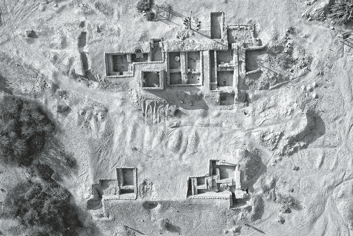 Fig. 4.
Aerial view of the [Roman] fort, with east at the top.
Davies and Magness (2015)
| Transliterated Name | Source | Name |
|---|---|---|
| Yotvata | Hebrew | יׇטְבָתָה |
| Iutfata | Arabic | يوتفاتا |
| Ein Ghadian | Arabic | يين عهاديان |
- Fig. 2.1 Map of Yotvata and
environs from Singer-Avitz and Ayalon(2019)
 Fig. 2.1
Map of the surveyed roads in the Eilat region - most sites are Nabatean-Roman but the same roads were used in all periods
(adapted from Fig. 1 in Avner, 2108)
Singer-Avitz and Ayalon (2019) - Yotvata environs in Google Earth
 Yotvata environs
click on image to explore this site on a new tab in Google Earth - Yotvata environs on govmap.gov.il
 Yotvata environs
click on image to explore this site on a new tab in govmap.gov.il - Roman Fort at Yotvata in Google Earth
 Roman Fort at Yotvata
click on image to explore this site on a new tab in Google Earth - Roman Fort at Yotvata on govmap.gov.il
 Roman Fort at Yotvata
click on image to explore this site on a new tab in govmap.gov.il - Fig. 2 Aerial view of the
Arava Valley with the Yotvata fort in the foreground from Davies and Magness (2015)
 Fig. 2
Aerial view of the Arava Valley, looking north, with the Yotvata fort in the foreground.
Davies and Magness (2015) - Fig. 3.1 Yotvata Hill where
the Iron I fortress is located from Singer-Avitz and Ayalon(2019)
 Fig. 3.1
Yotvata Hill, looking northwest
(photo Uzi Avner)
Singer-Avitz and Ayalon (2019)
- Fig. 3.2 Plan of Yotvata Hill
from Singer-Avitz and Ayalon(2019)
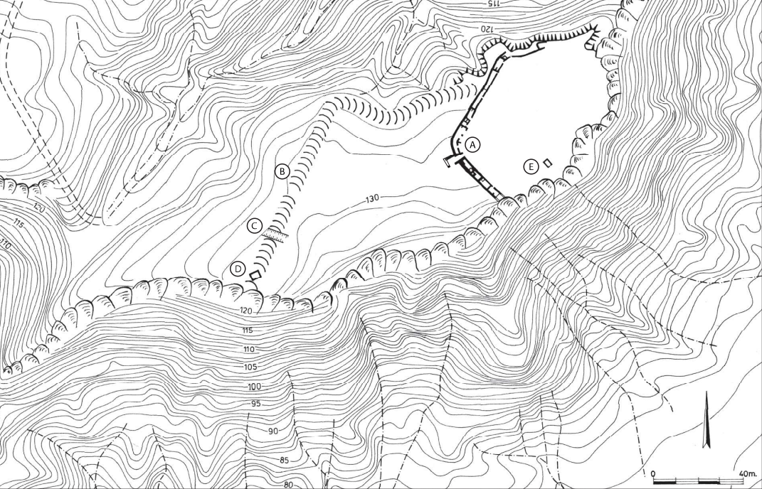 Fig. 3.2
Plan of Yotvata Hill:
- Iron I casemate wall
- earthen rampart
- section in earthen rampart
- Nabataean built tomb
- Early Islamic building
Singer-Avitz and Ayalon (2019) - Fig. 3.2 Aerial photograph of
Yotvata Hill from Singer-Avitz (2019)
 Fig. 6
Aerial photograph of Givat Yotvata (Yotvata Hill):
- fence wall (Yotvata Hill)
- dirt embankment
- cut in the dirt embankment
- Nabataean tomb structure
- a building from the Early Islamic period
(Photo: Uzi Avner)
Singer-Avitz (2019) - Plan of the "castle" from
Iron Age I - from Singer-Avitz (2019)
 Plan of the "castle" from Iron Age I
Singer-Avitz (2019) - Fig. 4 Plan of Nabatean
structure from Erickson-Gini (2012a)
 Figure 4
Plan
Erickson-Gini (2012a) - Fig. 5 Plan of the Roman
fortress from Davies and Magness (2015)
 Fig. 6
Plan of the fort, indicating the excavation area and room numbers.
Davies and Magness (2015) - Plan of the Early Arab
structure in its main phase from Stern et. al. (1993 v.4)
 Plan of the main Early Arab structure in its main phase
Stern et. al. (1993 v.4)
- Plan of the "castle" from
Iron Age I - from Singer-Avitz (2019)
Plan of the "castle" from Iron Age I
Singer-Avitz (2019) - Fig. 4 Plan of Nabatean
structure from Erickson-Gini (2012a)
Figure 4
Plan
Erickson-Gini (2012a)
- Fig. 3.16 Fragmented storage
jars in Casemate Room 20A of Iron Age Fortress on Yotvata Hill from Singer-Avitz and Ayalon(2019)
 Fig. 3.16
Fragmented storage jars in Casemate Room 20A, looking south
Singer-Avitz and Ayalon (2019)
- Fig. 4 - Plan of Nabatean structure
from Erickson-Gini (2012a)
Figure 4
Plan
Erickson-Gini (2012a) - Fig. 7 - Aqaba Ware jar, crushed in situ
from Erickson-Gini (2012a)
 Figure 7
Aqaba Ware jar, crushed in situ, looking north.
Erickson-Gini (2012a) - Fig. 8 - Collapsed ceiling slabs
from Erickson-Gini (2012a)
 Figure 8
Upright, collapsed ceiling slabs (F2), looking north
Erickson-Gini (2012a)
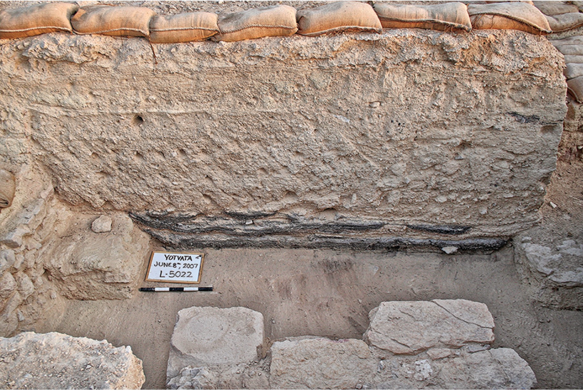 Fig. 7
West baulk of Room 4, showing the mud-brick collapse
JW: Stratigraphy of Yotvata - burnt layer at bottom is overlain by mud brick collapse layer and sedimentation until the top Early Islamic layer
Davies and Magness (2015)
Davies et al (2015) excavated a Roman Fort at Yotvata from 2003-2007. A monumental Latin inscription discovered earlier (1985) outside of the east gate
suggests that the fort at Yotvata was built when Diocletian transferred the Tenth Legion Fretensis from Jerusalem to Aila in the last decade of the third century.Two destruction layers were described after establishment of the fort - a burned layer and a collapse layer. The authors noted that
the first phase of Roman occupation at our fort, which is associated with coins that go up to ca. 360, ended with a violent destruction evidenced by intense burning throughout.Reconstruction is said to have occurred immediately after this destruction as documented by a
series of successive floor layers throughout. The cause of the burned layer was not established but the authors suggested a
a possible connection with the Saracen revolt against Rome led by Queen Mavia, ca. 375–378noting the documented successes of her forces against Roman field armies and that
the inclusion of former foederati among her troops suggest that her forces would have been capable of taking and destroying the fort at Yotvata.Whatever the specific cause, the excavators strongly believed that human agency rather than the southern Cyril Quake of 363 AD was the general cause noting that there was no visible evidence of structural damage or a collapse layer. One of the excavators, Gwyn Davies (personal communication, 2020) noted that
We are confident that the fort was destroyed in a violent attack as we encountered signs of intense burning across most contexts and, even more suggestively, the stone frame of the main gate was fire-seared as well. If the fire had been more localized and associated with signs of toppling collapse, then ‘natural causes’ may have been more persuasive or, indeed, that this represented an accidental destruction. Instead, the evidence suggests to us that the fort was put to the torch quite deliberatelyAnother of the excavators, Jodi Magness (personal communication, 2020) related the following
In addition to the lack of evidence of visible structural damage that could be attributed to an earthquake in the earliest destruction level, the absence of whole (restorable) pottery vessels and other objects in that level suggests an earthquake did not cause the destruction, as one would expect these artifacts to be buried in a sudden collapse. Therefore, we attributed the destruction by fire to human agents.As for the collapse layer, it is dated to after the abandonment of the fort in the late 4th century.
The Late Roman occupation ended with an orderly evacuation and abandonment, as indicated by the fact that the rooms were cleared out. The absence of a reference to a fort at Osia [i.e. the fort excavated near Yotvata] in the Notitia Dignitatum, together with a reference to the ala Constantiana being stationed at Toloha (Or. 34.34), ca. 110 km to the north of Yotvata, suggest that our fort was abandoned by the early fifth century. Soon thereafter an earthquake—perhaps the earthquake of 419—toppled the walls of the fort. An ephemeral Byzantine period occupation was established on top of the collapse, without any attempt at leveling.A limited amount of debris between the fort's presumed abandonment and the collapse layer led the authors to suggest the Monaxius and Plinta Earthquake of 419 AD as a possible cause of the collapse layer. Although the ensuing ephemeral Byzantine period occupation was undated due to a lack of recovered pottery, significant sediment accumulated between the Byzantine layer and the well dated Early Islamic layer suggesting that these two layers are
a century or two apart. This eliminates several potential local earthquake candidates - e.g. the Inscription at Areopolis Quake (late 6th century), the Sign of the Prophet Quake (613-622 CE), and the Sword in the Sky Quake (634 CE). Archeoseismic evidence at Yotvata for the 419 CE Monaxius and Plinta earthquake should be considered as possible to probable. The excavators say possible and I say possible to probable.
| Effect | Location | Image(s) | Description |
|---|---|---|---|
| Collapsed Exterior Walls and Ceiling slabs | Upper Storey - Loci L100, L500, and L600
Figure 4 Plan Erickson-Gini (2012a) |
Figure 8 Upright, collapsed ceiling slabs (F2), looking north Erickson-Gini (2012a) |
|
| Crushed pottery | deep in L502
Figure 4 Plan Erickson-Gini (2012a) |
Figure 7 Aqaba Ware jar, crushed in situ, looking north. Erickson-Gini (2012a) |
|
| Effect | Location | Image(s) | Description |
|---|---|---|---|
| Collapsed Walls | Entire fortress ?
Fig. 6 Plan of the fort, indicating the excavation area and room numbers. Davies and Magness (2015) |
Fig. 7 West baulk of Room 4, showing the mud-brick collapse JW: Stratigraphy of Yotvata - burnt layer at bottom is overlain by mud brick collapse layer and sedimentation until the top Early Islamic layer Davies and Magness (2015) |
|
| Toppled Steps | Southwest Staircase
Fig. 6 Plan of the fort, indicating the excavation area and room numbers. Davies and Magness (2015) |
 Fig. 9
Southwest staircase showing toppled steps, looking east Davies and Magness (2015) |
|
- Modified by JW from Fig. 4 of Erickson-Gini (2012a)
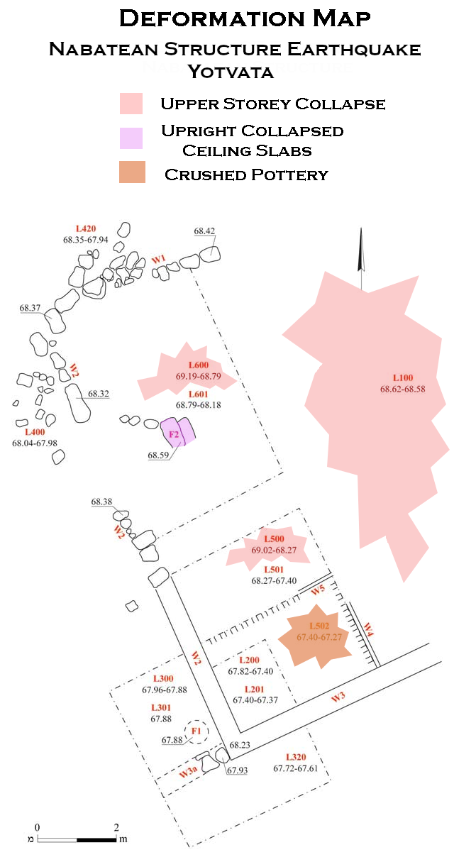 Deformation Map
click on image to open in a new tab
Modified by JW from Fig. 4 of Erickson-Gini (2012a)
- Earthquake Archeological Effects chart
of Rodríguez-Pascua et al (2013: 221-224)
 Earthquake Archeological Effects (EAE)
Rodríguez-Pascua et al (2013: 221-224)
| Effect | Location | Image(s) | Description | Intensity |
|---|---|---|---|---|
| Collapsed Exterior Walls and Ceiling slabs | Upper Storey - Loci L100, L500, and L600
Figure 4 Plan Erickson-Gini (2012a) |
Figure 8 Upright, collapsed ceiling slabs (F2), looking north Erickson-Gini (2012a) |
|
VIII + |
| Crushed pottery | deep in L502
Figure 4 Plan Erickson-Gini (2012a) |
Figure 7 Aqaba Ware jar, crushed in situ, looking north. Erickson-Gini (2012a) |
|
VII + |
- Earthquake Archeological Effects chart
of Rodríguez-Pascua et al (2013: 221-224)
Earthquake Archeological Effects (EAE)
Rodríguez-Pascua et al (2013: 221-224)
| Effect | Location | Image(s) | Description | Intensity |
|---|---|---|---|---|
| Collapsed Walls | Entire fortress ?
Fig. 6 Plan of the fort, indicating the excavation area and room numbers. Davies and Magness (2015) |
Fig. 7 West baulk of Room 4, showing the mud-brick collapse JW: Stratigraphy of Yotvata - burnt layer at bottom is overlain by mud brick collapse layer and sedimentation until the top Early Islamic layer Davies and Magness (2015) |
|
VIII + |
| Toppled Steps | Southwest Staircase
Fig. 6 Plan of the fort, indicating the excavation area and room numbers. Davies and Magness (2015) |
Fig. 9 Southwest staircase showing toppled steps, looking east Davies and Magness (2015) |
|
VIII + |