Samak (aka Shiqmona)
 Aerial View of Samak
Click on Image for high resolution magnifiable image
Drone Photo by Jefferson Williams 18 March 2023
| Transliterated Name | Language | Name |
|---|---|---|
| Samak | Arabic | |
| Tell es-Samak | Arabic | تل السمك |
| Tel Shiqmona | Hebrew | תל שִׁקְמוֹנָה |
| Sycamine | Greek/Roman name | |
| Porphyreon | Crusader |
- Annotated Aerial View from
biblewalks.com
- Tel Samak in Google Earth
 Tel Samak
click on image to explore this site on a new tab in Google Earth - Tel Samak on govmap.gov.il
 Tel Samak on govmap.gov.il
click on image to explore this site on a new tab in govmap.gov.il

- Site plan from Torge and 'Ad (2012)
 .הנומקש לת לש םייחרזמה םיילושה ךרואל הריפחה יחטש .2 רויא
Torge and 'Ad (2012) - Fig. 2 - Area A plan from
Torge and 'Ad (2012)
 .םיכתחו תינכת :A חטש .1 תינכת
Torge and 'Ad (2012) - Plan 4 - Area D/E plan
from Torge and 'Ad (2012)
 Plan 4
Area D/E: plan and sections.
Torge and 'Ad (2012)
- Site plan from Torge and 'Ad (2012)
.הנומקש לת לש םייחרזמה םיילושה ךרואל הריפחה יחטש .2 רויא
Torge and 'Ad (2012) - Fig. 2 - Area A plan from
Torge and 'Ad (2012)
.םיכתחו תינכת :A חטש .1 תינכת
Torge and 'Ad (2012) - Plan 4 - Area D/E plan
from Torge and 'Ad (2012)
Plan 4
Area D/E: plan and sections.
Torge and 'Ad (2012)
- This archaeoseismic evidence is debated. Hagit Torge, the original excavator, disputes a seismic origin and ascribes wall deformations to active soil (personal communication, 2021). Taxel (2013:79-80) casts doubt as to whether the observed deformations have a seismic origin
| Effect | Location | Image(s) | Observation |
|---|---|---|---|
| Displaced Walls Rotated Stones Uplifted Stones Tilted Walls Folded Walls |
Area A
.םיכתחו תינכת :A חטש .1 תינכת
Torge and 'Ad (2012) |
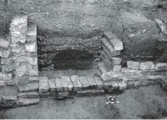 Fig. 3
Foundations and layers of fill in the northern part of Area A, looking southeast; in foreground, W3. Torge and 'Ad (2012)  Fig. 4
Wall 8b in Area A, looking southwest. Torge and 'Ad (2012)  Fig. 5
The corner formed by W5 (opposite) and W8a (left) in Area A, looking northeast. In foreground to left, the bedrock foundation of the box. Torge and 'Ad (2012)  Fig. 6
Walls 8c and 8d in Area A, looking southwest. Torge and 'Ad (2012) |
|
| Deformed Foundations | Area D/E
Plan 4 Area D/E: plan and sections. Torge and 'Ad (2012) 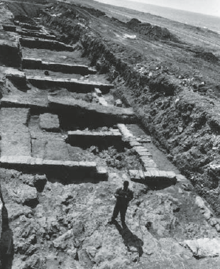 Fig. 11
The building in Area D/E, general view, looking southeast. On left, the foundation of the mosaic pavement (L420). Torge and 'Ad (2012) 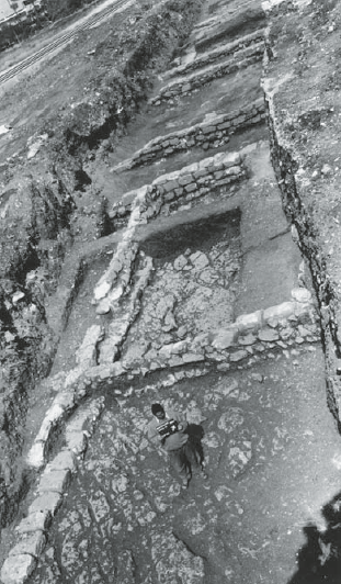 Fig. 12
Area D/E, general view, looking north. Torge and 'Ad (2012) |
|
- Modified by JW from Fig. 2 of Torge and 'Ad (2012)
 Deformation Map
Click on image to open in a new tab
modified by JW from Fig. 2 of Torge and 'Ad (2012)
 Orthophoto of Samak - entire site
Click on Image for high resolution magnifiable image
Drone Photos by Jefferson Williams 18 March 2023
 Orthophoto of Samak - north part of site (the Tel)
Click on Image for high resolution magnifiable image
Drone Photos by Jefferson Williams 18 March 2023
 Orthophoto of Samak - south part of site
Click on Image for high resolution magnifiable image
Drone Photos by Jefferson Williams 18 March 2023