Beth She'an
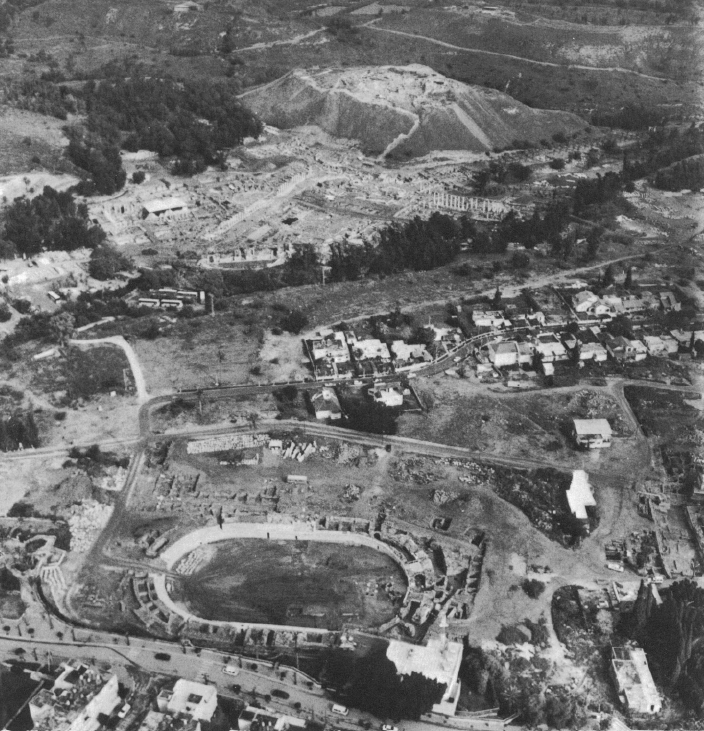 Figure 2
Ancient Bet Shean, looking north, showing the southern plateau and the amphitheater (in the modern town) (bottom), and the tell, the valley of Nahal `Amal, and the civic center (center)
Tsafrir and Foester (1997)
| Transliterated Name | Language | Name |
|---|---|---|
| Beth She'an | Hebrew | בֵּית שְׁאָן |
| Beit She'an | Hebrew | בֵּית שְׁאָן |
| Beisan | Arabic | بيسان |
| Baysān | Arabic | بيسان |
| Kurat Baysān | Arabic | |
| Tell el-Husn | Arabic | تيلل يلءهوسن |
| Scythopolis | Greek | Σκυθόπολις |
| Nysa | Greek | Νῦσα |
| Nysa-Scythopolis | Greek | Νῦσα-Σκυθόπολις |
| Beshan | Semitic | |
| Beshan | Semitic | |
| Beth-sâªl | Egyptian Texts | |
| Tell Iztabba |
- Fig. 10 Soil Map of
the area surrounding Beth Shean from Lorenzon (2024)
 Fig. 10
Geological map of the area
drawing by Maija Holappa after Dan and Raz (1970) and Sneh et al. (1997)
Lorenzon (2024)
- Fig. 10 Soil Map of
the area surrounding Beth Shean from Lorenzon (2024)
Fig. 10
Geological map of the area
drawing by Maija Holappa after Dan and Raz (1970) and Sneh et al. (1997)
Lorenzon (2024)
- Wide Aerial View of Beth
Shean from Amihai Mazar in Stern et. al. (2008)
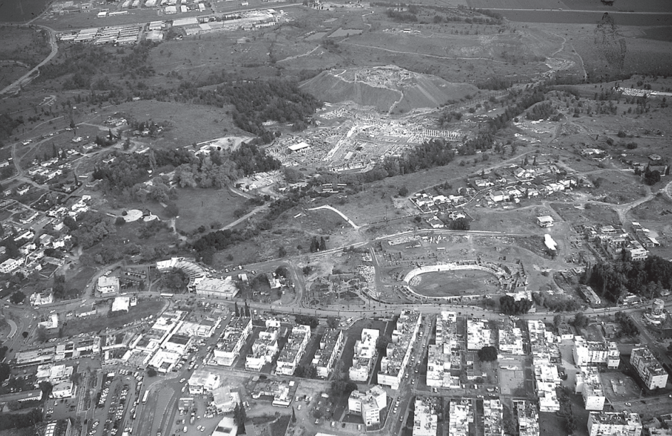 View of the ancient site (at top), the amphitheater, and the modern town (at bottom), looking north.
Stern et. al. (2008) - Tighter Aerial View of Beth
Shean from Tsafrir and Foester (1997)
Figure 2
Ancient Bet Shean, looking north, showing the southern plateau and the amphitheater (in the modern town) (bottom), and the tell, the valley of Nahal `Amal, and the civic center (center)
Tsafrir and Foester (1997) - Aerial View of Tel Beth Shean
from Amihai Mazar in Stern et. al. (2008)
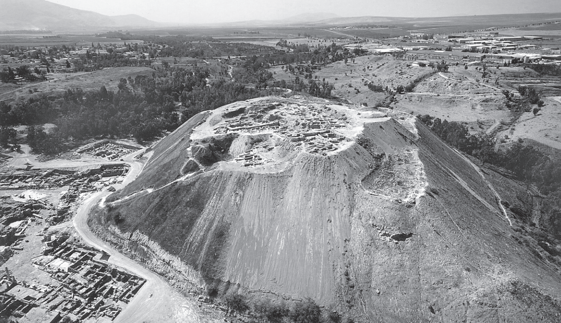 Aerial View of Tel Beth Shean
Stern et. al. (2008) - Photo 1.1 Aerial View of
Tel Beth Shean from Panitz-Cohen and Mazar (2009)
 Photo 1.1
Aerial view of Tel Beth-Shean, looking west.
- Front: Areas S
- Behind it: Areas N and Q
- Left: Areas M and R
(photo: Albatross, 1994).
Panitz-Cohen and Mazar (2009) - Photo 1.2 Aerial View of
Tel Beth Shean Summit with Areas Q, R, S, and N labeled from Panitz-Cohen and Mazar (2009)
 Photo 1.2
Aerial view of the tell’s summit, looking south.
- Right: Areas Q
- Top: Area R
- Left: Area S
- Center: Area N before the start of excavations (burnt area) (1992)
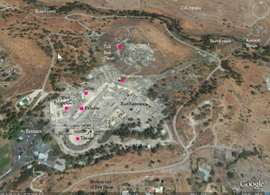
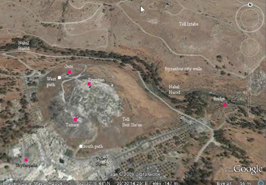
Panitz-Cohen and Mazar (2009) - Bet Shean in Google Earth
 Bet Shean
click on image to explore this site on a new tab in Google Earth - Bet Shean on govmap.gov.il
 Bet Shean
click on image to explore this site on a new tab in govmap.gov.il - Annotated Google Satellite
Map of Bet She'an from BibleWalks.com
 Bet Shean
click on image to explore this site on a new tab in Google Earth
Used with permission from BibleWalks.com - Annotated Google Satellite
Map of Tel Bet She'an from BibleWalks.com
 Tel Bet Shean
click on image to explore this site on a new tab in Google Earth
Used with permission from BibleWalks.com - Annotated Google Satellite
Map of Tell Iztabba from BibleWalks.com
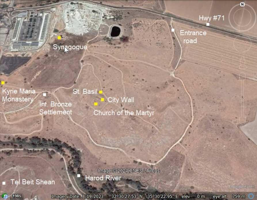 Tell Iztabba
click on image to explore this site on a new tab in Google Earth
Used with permission from BibleWalks.com
- Plan of Tel Beth Shean with
city walls from Amihai Mazar in Stern et. al. (2008)
 Beth-Shean (Scythopolis): plan of the site.
Stern et. al. (2008) - Fig. C General map of
Scythopolis/Bet Shean/Baysān from Tsafrir and Foester (1997)

Figure C
General map of Scythopolis — Bet Shean
- Civic center
- Theater
- Western bathhouse
- Palladius Street
- Valley Street
- Northeast gate and Byzantine bazaar
- Hellenistic quarter on Tel Iztaba
- Hellenistic building
- Northwest gate
- Monastery of the Lady Mary
- Church of the Martyr
- Andreas' Church
Tsafrir and Foester (1997) - Lidar Scan of City
Model from the Archaeological Park - taken by JW
 Bet She'an city model at the archaeological park
Click on Image to open a 3D view of this in a new tab
Screen capture from 3D Lidar Scan by Jefferson Williams on 2 May 2023
- Plan of Tel Beth Shean with
city walls from Amihai Mazar in Stern et. al. (2008)
Beth-Shean (Scythopolis): plan of the site.
Stern et. al. (2008) - Fig. C General map of
Scythopolis/Bet Shean/Baysān from Tsafrir and Foester (1997)
Figure C
General map of Scythopolis — Bet Shean
- Civic center
- Theater
- Western bathhouse
- Palladius Street
- Valley Street
- Northeast gate and Byzantine bazaar
- Hellenistic quarter on Tel Iztaba
- Hellenistic building
- Northwest gate
- Monastery of the Lady Mary
- Church of the Martyr
- Andreas' Church
Tsafrir and Foester (1997) - Lidar Scan of City
Model from the Archaeological Park - taken by JW
Bet She'an city model at the archaeological park
Click on Image to open a 3D view of this in a new tab
Screen capture from 3D Lidar Scan by Jefferson Williams on 2 May 2023
- Map of the Mound showing
of Hebrew University expedition from Amihai Mazar in Stern et. al. (2008)
 Tel Beth-Shean
topographic map showing excavation areas excavation areas of Hebrew University expedition.
Stern et. al. (2008) - Fig. 1.1 Tel Beth-Shean
site plan with excavation areas from Panitz-Cohen and Mazar (2009)
 Fig. 1.1
Topographic plan of Tel Beth-Shean with location of excavation areas
Panitz-Cohen and Mazar (2009)
- Map of the Mound showing
of Hebrew University expedition from Amihai Mazar in Stern et. al. (2008)
Tel Beth-Shean
topographic map showing excavation areas excavation areas of Hebrew University expedition.
Stern et. al. (2008) - Fig. 1.1 Tel Beth-Shean
site plan with excavation areas from Panitz-Cohen and Mazar (2009)
Fig. 1.1
Topographic plan of Tel Beth-Shean with location of excavation areas
Panitz-Cohen and Mazar (2009)
- Fig. 4.2 Schematic
plan of Stratum S-4 from Panitz-Cohen and Mazar (2009:95)
 Fig. 4.2
Schematic plan of Stratum S-4
Panitz-Cohen and Mazar (2009) - Fig. 4.3a Schematic
plan of northern part Stratum S-4 from Panitz-Cohen and Mazar (2009:95)
 Fig. 4.3a
Plan of Stratum S-4, northern part
Panitz-Cohen and Mazar (2009) - Fig. 4.3b Schematic
plan of southern part Stratum S-4 from Panitz-Cohen and Mazar (2009:95)
 Fig. 4.3b
Plan of Stratum S-4, southern part
Panitz-Cohen and Mazar (2009)
- Fig. 4.2 Schematic
plan of Stratum S-4 from Panitz-Cohen and Mazar (2009:95)
Fig. 4.2
Schematic plan of Stratum S-4
Panitz-Cohen and Mazar (2009) - Fig. 4.3a Schematic
plan of northern part Stratum S-4 from Panitz-Cohen and Mazar (2009:95)
Fig. 4.3a
Plan of Stratum S-4, northern part
Panitz-Cohen and Mazar (2009) - Fig. 4.3b Schematic
plan of southern part Stratum S-4 from Panitz-Cohen and Mazar (2009:95)
Fig. 4.3b
Plan of Stratum S-4, southern part
Panitz-Cohen and Mazar (2009)
- Fig. 4.5a Plan of Stratum S-3b,
northern part from Panitz-Cohen and Mazar (2009:95)
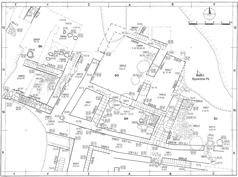 Fig. 4.5a
Plan of Stratum S-3b, northern part
click on image to open in a new tab
Panitz-Cohen and Mazar (2009) - Fig. 4.5b Plan of Stratum S-3b,
southern part from Panitz-Cohen and Mazar (2009:95)
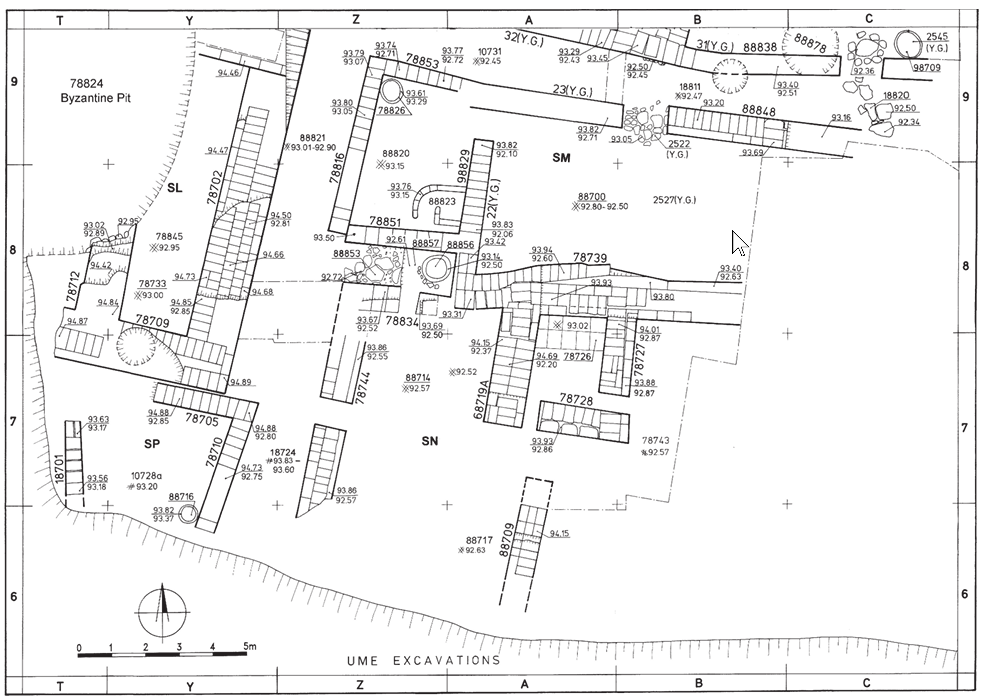 Fig. 4.5b
Plan of Stratum S-3b, southern part
click on image to open in a new tab
Panitz-Cohen and Mazar (2009) - Fig. 4.6a Plan of Stratum S-3a,
northern part from Panitz-Cohen and Mazar (2009:95)
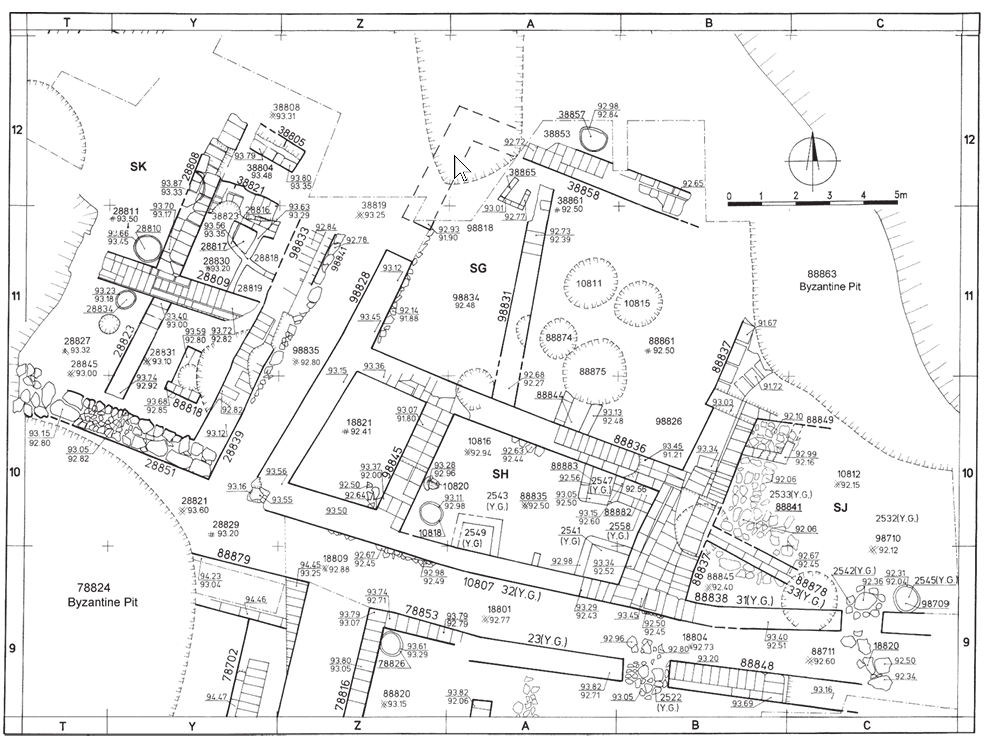 Fig. 4.6a
Plan of Stratum S-3a, northern part
click on image to open in a new tab
Panitz-Cohen and Mazar (2009) - Fig. 4.6b Plan of Stratum S-3a,
southern part from Panitz-Cohen and Mazar (2009:95)
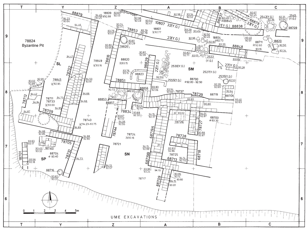 Fig. 4.6b
Plan of Stratum S-3a, southern part
click on image to open in a new tab
Panitz-Cohen and Mazar (2009)
- Fig. 4.5a Plan of Stratum S-3b,
northern part from Panitz-Cohen and Mazar (2009:95)
Fig. 4.5a
Plan of Stratum S-3b, northern part
click on image to open in a new tab
Panitz-Cohen and Mazar (2009) - Fig. 4.5b Plan of Stratum S-3b,
southern part from Panitz-Cohen and Mazar (2009:95)
Fig. 4.5b
Plan of Stratum S-3b, southern part
click on image to open in a new tab
Panitz-Cohen and Mazar (2009) - Fig. 4.6a Plan of Stratum S-3a,
northern part from Panitz-Cohen and Mazar (2009:95)
Fig. 4.6a
Plan of Stratum S-3a, northern part
click on image to open in a new tab
Panitz-Cohen and Mazar (2009) - Fig. 4.6b Plan of Stratum S-3a,
southern part from Panitz-Cohen and Mazar (2009:95)
Fig. 4.6b
Plan of Stratum S-3a, southern part
click on image to open in a new tab
Panitz-Cohen and Mazar (2009)
- Fig. 1.4 Plan of UME
Level VI and Late Level VI from Panitz-Cohen and Mazar (2009)
 Fig. 1.4
Plan of UME Level VI and Late Level VI
(James 1966: Fig. 77)
(courtesy of the University Museum, University of Pennsylvania)
Panitz-Cohen and Mazar (2009)
- Fig. 1.4 Plan of UME
Level VI and Late Level VI from Panitz-Cohen and Mazar (2009)
Fig. 1.4
Plan of UME Level VI and Late Level VI
(James 1966: Fig. 77)
(courtesy of the University Museum, University of Pennsylvania)
Panitz-Cohen and Mazar (2009)
- Fig.1.6 Schematic
plan of Stratum R-2 from Mazar and Mullins (2007)
 Fig. 1.6
Schematic plan of Stratum R-2
Click on Image to open in a new tab
Mazar and Mullins (2007) - Fig.3.3 Plan showing
oval crater from Mazar and Mullins (2007)
 Fig. 3.3
Plan of the oval crater showing location of probes
Click on Image to open in a new tab
Mazar and Mullins (2007) - Fig.3.17 Schematic
plan of Stratum R-2 from Mazar and Mullins (2007)
 Fig. 3.17
Schematic plan of Stratum R-2
Click on Image to open in a new tab
Mazar and Mullins (2007) - Fig.3.18 Reduced
plan of Stratum R-2 from Mazar and Mullins (2007)
 Fig. 3.18
Reduced plan of Stratum R-2
Click on Image to open in a new tab
Mazar and Mullins (2007) - Fig.3.19 Isometric
view of Temple 58066 from Mazar and Mullins (2007)
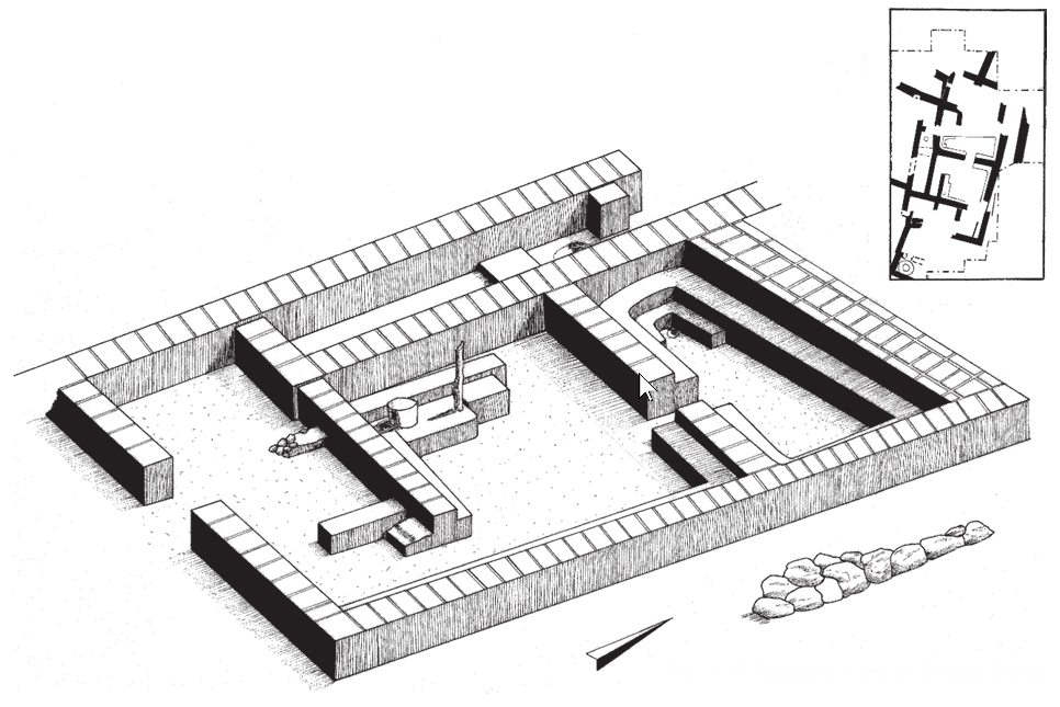 Fig. 3.18
Isometric view of Temple 58066
Click on Image to open in a new tab
Mazar and Mullins (2007)
- Fig. 1.6 Schematic
plan of Stratum R-2 from Mazar and Mullins (2007)
Fig. 1.6
Schematic plan of Stratum R-2
Click on Image to open in a new tab
Mazar and Mullins (2007) - Fig.3.3 Plan showing
oval crater from Mazar and Mullins (2007)
Fig. 3.3
Plan of the oval crater showing location of probes
Click on Image to open in a new tab
Mazar and Mullins (2007) - Fig.3.17 Schematic
plan of Stratum R-2 from Mazar and Mullins (2007)
Fig. 3.17
Schematic plan of Stratum R-2
Click on Image to open in a new tab
Mazar and Mullins (2007) - Fig.3.18 Reduced
plan of Stratum R-2 from Mazar and Mullins (2007)
Fig. 3.18
Reduced plan of Stratum R-2
Click on Image to open in a new tab
Mazar and Mullins (2007) - Fig.3.19 Isometric
view of Temple 58066 from Mazar and Mullins (2007)
Fig. 3.18
Isometric view of Temple 58066
Click on Image to open in a new tab
Mazar and Mullins (2007)
- Plan of city center of
Beth Shean from Amihai Mazar in Stern et. al. (2008)
 Beth-Shean (Scythopolis): plan of the city center.
Stern et. al. (2008) - Fig. D Map of the central
area of Scythopolis/Bet Shean/Baysān from Tsafrir and Foester (1997)

Figure D
Map of the central area of Scythopolis—Bet Shean (excavations of the Hebrew University and the Israel Antiquities Authority
- Theater
- Portico in front of the Theater
- Western bathhouse
- Propylon in Palladius Street
- Shops of the Roman Period
- Palladius Street
- Sigma
- Odeaon
- Collonnades and reconstructed Roman temenos (?)
- Dismantled Roman colonnades,with a Byzantine public building above them
- Northern Street
- Propylon and stairway to the tell
- Propylon between the temple esplanade and the tell
- Temple with the round cella
- Nymphaeum
- Monument of Antonius
- Valley Street
- Central Monument
- Roman basilica, with porticoes of the Byzantine agora above it
- Byzantine agora
- Umayyad ceramic workshop
- Roman temple
- Roman cult structures
- Public latrine
- Eastern bathhouse
- Roman portico, later Silvanus Hall
- Roman decorative pool, with Umayyad shops above it
- Silvanus Street (JW: Row of shops where coin hoard providing terminus post quem for 749 quake was found)
- Semicircular plaza
Tsafrir and Foester (1997) - Fig. 4.4 Map of central
Scythopolis/Bet Shean/Baysān from Blanke and Walmsley (2022)
 Figure 4.4
Map of central Baysān (from R. Bar-Nathan and W. Atrash, Baysān, 5, plan 1.3).
Blanke and Walmsley (2022) - Lidar Scan of City
Model from the Archaeological Park - taken by JW
 Bet She'an city model at the archaeological park
Click on Image to open a 3D view of this in a new tab
Screen capture from 3D Lidar Scan by Jefferson Williams on 2 May 2023
- Plan of city center of
Beth Shean from Amihai Mazar in Stern et. al. (2008)
Beth-Shean (Scythopolis): plan of the city center.
Stern et. al. (2008) - Fig. D Map of the central
area of Scythopolis/Bet Shean/Baysān from Tsafrir and Foester (1997)
Figure D
Map of the central area of Scythopolis—Bet Shean (excavations of the Hebrew University and the Israel Antiquities Authority
- Theater
- Portico in front of the Theater
- Western bathhouse
- Propylon in Palladius Street
- Shops of the Roman Period
- Palladius Street
- Sigma
- Odeaon
- Collonnades and reconstructed Roman temenos (?)
- Dismantled Roman colonnades,with a Byzantine public building above them
- Northern Street
- Propylon and stairway to the tell
- Propylon between the temple esplanade and the tell
- Temple with the round cella
- Nymphaeum
- Monument of Antonius
- Valley Street
- Central Monument
- Roman basilica, with porticoes of the Byzantine agora above it
- Byzantine agora
- Umayyad ceramic workshop
- Roman temple
- Roman cult structures
- Public latrine
- Eastern bathhouse
- Roman portico, later Silvanus Hall
- Roman decorative pool, with Umayyad shops above it
- Silvanus Street (JW: Row of shops where coin hoard providing terminus post quem for 749 quake was found)
- Semicircular plaza
Tsafrir and Foester (1997) - Fig. 4.4 Map of central
Scythopolis/Bet Shean/Baysān from Blanke and Walmsley (2022)
Figure 4.4
Map of central Baysān (from R. Bar-Nathan and W. Atrash, Baysān, 5, plan 1.3).
Blanke and Walmsley (2022) - Lidar Scan of City
Model from the Archaeological Park - taken by JW
Bet She'an city model at the archaeological park
Click on Image to open a 3D view of this in a new tab
Screen capture from 3D Lidar Scan by Jefferson Williams on 2 May 2023
- Fig. F Southeast end of
Silvanus Street (Earthquake debris) from Tsafrir and Foester (1997)

Figure F
Segment of the remains near the southeast end of Silvanus Street, showing the collapsed shops and arcade after the earthquake of 749 C.E. (after Foerster and Tsafrir, ESI 11 [1992], fig. 45)
- Silvanus Street (only the central line of stone is marked on the plan)
- Facade and arcade of the Umayyad shops as collapsed in the earthquake of 749 C.E
- Later Umayyad building and installations
- Facade of the Umayyad shops, built on top of the Roman decorative pool
- Umayyad shops
- Stylobate and line of the Roman colonnade, later blocked by the rear wall of the Umayyad shops
- A lane crossing the Umayyad bazaar
- Opus sectile segment of the promenade around the Roman pool
- Umayyad portico built along the rear side of the shops
- A base in the line of columns and piers of the Byzantine Silvanus Hall
Tsafrir and Foester (1997) - Lidar Scan of Collapsed
Storefronts on Silvanus Street by JW
 Collapsed Storefronts on Sylvanus Street (Bet She'an)
Click on Image to open a 3D View of this in a new tab
Screenshot from 3D Lidar Scan by Jefferson Williams - 2 May 2023
- Fig. F Southeast end of
Silvanus Street (Earthquake debris) from Tsafrir and Foester (1997)
Figure F
Segment of the remains near the southeast end of Silvanus Street, showing the collapsed shops and arcade after the earthquake of 749 C.E. (after Foerster and Tsafrir, ESI 11 [1992], fig. 45)
- Silvanus Street (only the central line of stone is marked on the plan)
- Facade and arcade of the Umayyad shops as collapsed in the earthquake of 749 C.E
- Later Umayyad building and installations
- Facade of the Umayyad shops, built on top of the Roman decorative pool
- Umayyad shops
- Stylobate and line of the Roman colonnade, later blocked by the rear wall of the Umayyad shops
- A lane crossing the Umayyad bazaar
- Opus sectile segment of the promenade around the Roman pool
- Umayyad portico built along the rear side of the shops
- A base in the line of columns and piers of the Byzantine Silvanus Hall
Tsafrir and Foester (1997)
- Fig. 4.0 Post-749 earthquake
administrative complex at Baysān from Blanke and Walmsley (2022)
 Figure 4.9
Plan of the post-749 earthquake administrative complex at Baysān, c. later eighth to eleventh centuries (based on G. M. Fitzgerald, Beth-Shan Excavations 1921–23. foldout plan, modified by Alan Walmsley).
Blanke and Walmsley (2022)
- Fig. 1 Site Plan of Tell
Iẓṭabba with excavation areas from Edrey et al. (2023)
 Fig. 1
Map of the area of Beth Shean
Edrey et al. (2023) - Fig. 17 Site Plan of Tell
Iẓṭabba with excavation areas from German-Israeli Tell Iẓṭabba Excavation Project Webpage
 Fig. 17
Map of Tell Iztabba with all Areas of excavation
German-Israeli Tell Iẓṭabba Excavation Project Webpage - Fig. 8 Site Plan of Tell
Iẓṭabba from German-Israeli Tell Iẓṭabba Excavation Project Webpage
 Fig. 8
Map of Tell Iztabba with Areas marked
(copyright: German-Israeli Tell Iẓṭabba Excavation Project)
German-Israeli Tell Iẓṭabba Excavation Project Webpage - Fig. 7 Interpretation of
magnetic data from Tell Iẓṭabba from German-Israeli Tell Iẓṭabba Excavation Project Webpage
 Fig. 7
Interpretation of magnetic data from Tell Iẓṭabba
(copyright: German-Israeli Tell Iẓṭabba Excavation Project)
German-Israeli Tell Iẓṭabba Excavation Project Webpage - Fig. 2 Site Plan of Tell
Iẓṭabba with excavation areas from Edrey et al. (2023)
 Fig. 2
Plan of Tell Iztabba (East) of the German-Israeli Tell Iztabba Excavation Project.
Edrey et al. (2023) - Fig. 1a Plan of Tel Itzabba
from Atrash et al. (2021)
 Fig. 1a
Tell Iẓṭabba site plan with indication of excavated areas dug by the Israel Antiquities Authority (IAA) and by the University of Münster & el Aviv University (UM-TAU)
Atrash et al. (2021)
- Fig. 1 Site Plan of Tell
Iẓṭabba with excavation areas from Edrey et al. (2023)
Fig. 1
Map of the area of Beth Shean
Edrey et al. (2023) - Fig. 17 Site Plan of Tell
Iẓṭabba with excavation areas from German-Israeli Tell Iẓṭabba Excavation Project Webpage
Fig. 17
Map of Tell Iztabba with all Areas of excavation
German-Israeli Tell Iẓṭabba Excavation Project Webpage - Fig. 8 Site Plan of Tell
Iẓṭabba from German-Israeli Tell Iẓṭabba Excavation Project Webpage
Fig. 8
Map of Tell Iztabba with Areas marked
(copyright: German-Israeli Tell Iẓṭabba Excavation Project)
German-Israeli Tell Iẓṭabba Excavation Project Webpage - Fig. 7 Interpretation of
magnetic data from Tell Iẓṭabba from German-Israeli Tell Iẓṭabba Excavation Project Webpage
Fig. 7
Interpretation of magnetic data from Tell Iẓṭabba
(copyright: German-Israeli Tell Iẓṭabba Excavation Project)
German-Israeli Tell Iẓṭabba Excavation Project Webpage - Fig. 2 Site Plan of Tell
Iẓṭabba with excavation areas from Edrey et al. (2023)
Fig. 2
Plan of Tell Iztabba (East) of the German-Israeli Tell Iztabba Excavation Project.
Edrey et al. (2023) - Fig. 1a Plan of Tel Itzabba
from Atrash et al. (2021)
Fig. 1a
Tell Iẓṭabba site plan with indication of excavated areas dug by the Israel Antiquities Authority (IAA) and by the University of Münster & el Aviv University (UM-TAU)
Atrash et al. (2021)
- Fig. 1b Plan of Area D
from Atrash et al. (2021) and German-Israeli Tell Iẓṭabba Excavation Project Webpage
 Fig. 1b
Tell Iẓṭabba, Area D
(UM-TAU).
Caption from Atrash et al. (2021)
Image from German-Israeli Tell Iẓṭabba Excavation Project Webpage - Fig. 2 Orthophoto of Area D
from Lorenzon (2024)
 Fig. 2
Ortho-photograph of Area D
(German-Israeli Tell Iẓṭabba Excavation Project 2020 Season)
Lorenzon (2024)
- Fig. 1b Plan of Area D
from Atrash et al. (2021) and German-Israeli Tell Iẓṭabba Excavation Project Webpage
Fig. 1b
Tell Iẓṭabba, Area D
(UM-TAU).
Caption from Atrash et al. (2021)
Image from German-Israeli Tell Iẓṭabba Excavation Project Webpage - Fig. 2 Orthophoto of Area D
from Lorenzon (2024)
Fig. 2
Ortho-photograph of Area D
(German-Israeli Tell Iẓṭabba Excavation Project 2020 Season)
Lorenzon (2024)
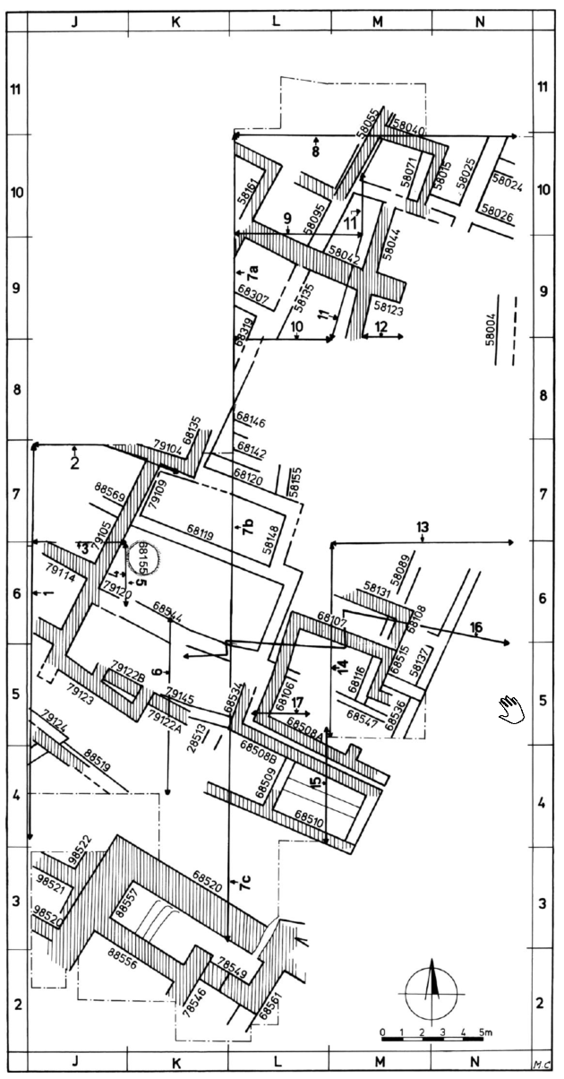 Figure 3.29
Location of stratigraphic sections: central and western part of Area R
Click on image to open in a new tab
Mazar and Mullins (2007)
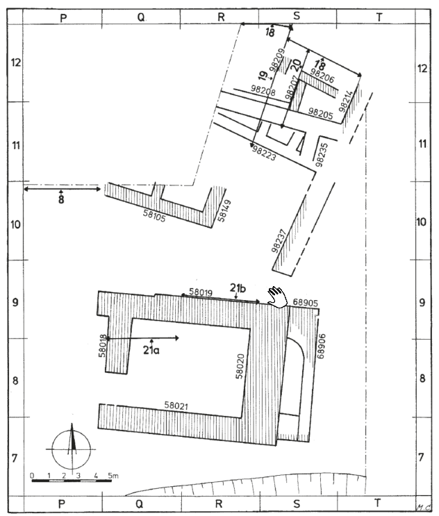 Figure 3.30
Location of stratigraphic sections: central and eastern part of Area R
Click on image to open in a new tab
Mazar and Mullins (2007)
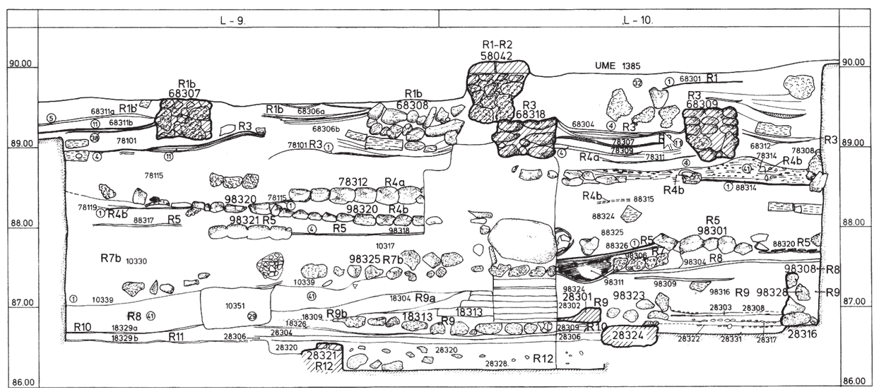 Figure 3.37
Section 7a (Sq. L/9-10, looking west)
Click on image to open in a new tab
Mazar and Mullins (2007)
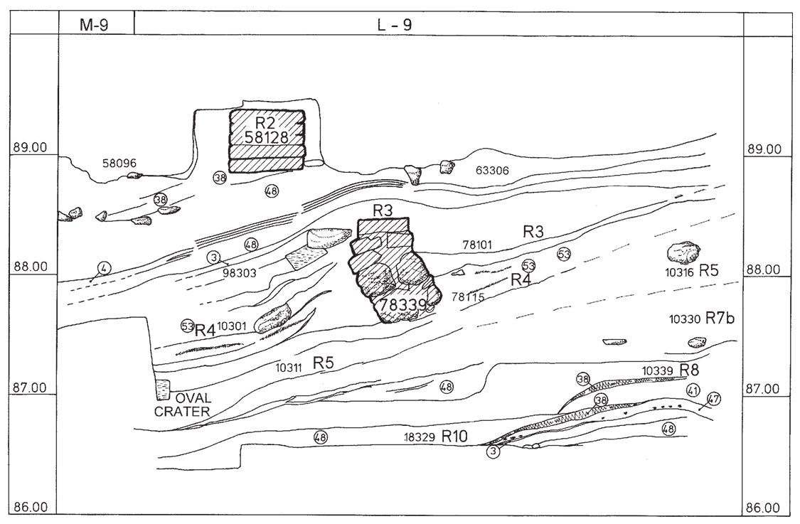 Figure 3.42
Section 10 (Sq. L/9, looking south)
Click on image to open in a new tab
Mazar and Mullins (2007)
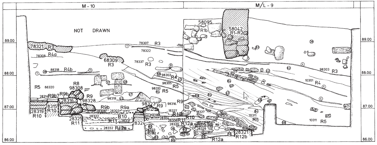 Figure 3.43
Section 11 (Sq. M/9-10, looking east)
Click on image to open in a new tab
Mazar and Mullins (2007)
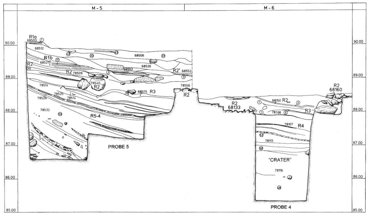 Figure 3.46
Section 14 (Sq. M/5-6, looking west)
Click on image to open in a new tab
Mazar and Mullins (2007)
- Artists Reconstruction
of Bet She'an form the south from Atrash et al. (2022)
 Cover Illustration
Artists Reconstruction of Bet She'an form the south
Atrash et al. (2022)
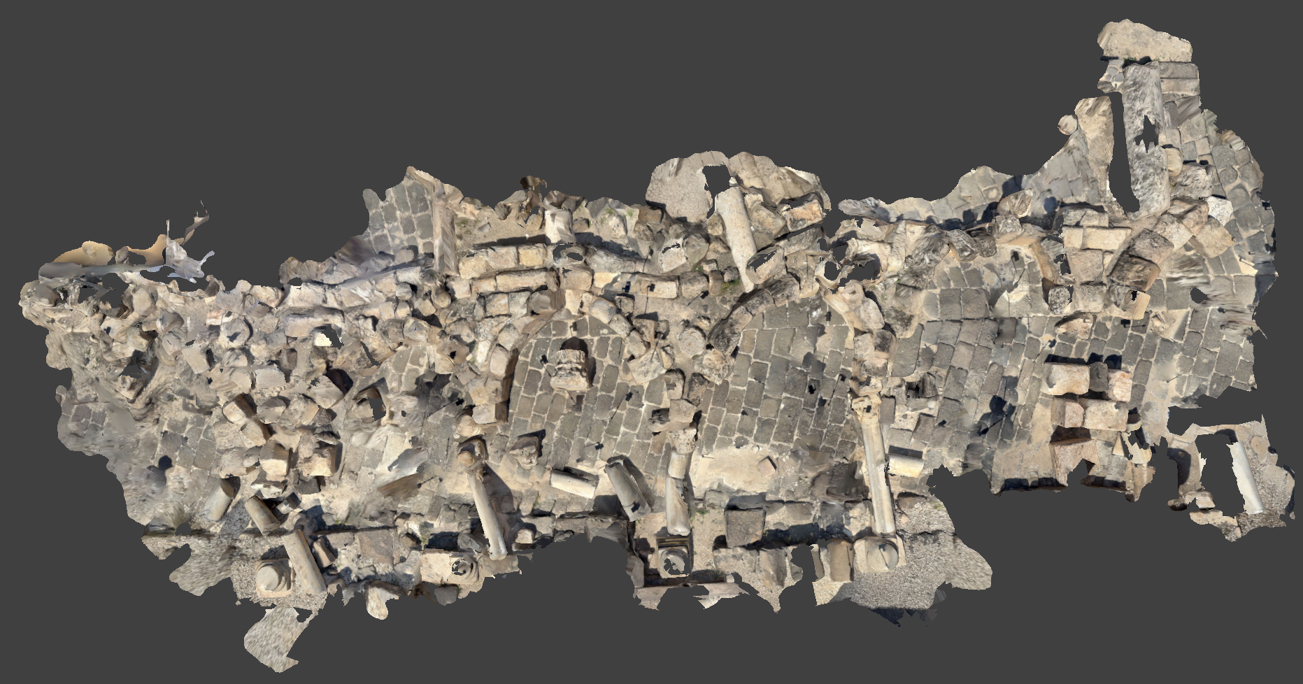
- the photos containing seismic destruction are largely due to one of the 749 CE Sabbatical Year Earthquakes
| Description | Photo | Reference |
|---|---|---|
| Plan View Drawing of Silvanus Street destruction |
Segment of the remains near the southeast end of Silvanus Street, showing the collapsed shops and arcade after the earthquake of 749 C.E. (after Foerster and Tsafrir, ESI 11 [1992], fig. 45)
Tsafrir and Foester (1997) |
Tsafrir and Foester (1997) |
| Junction of Valley Street and Silvanus Street |
 Figure 4
The junction of Valley Street (right), Silvanus Street (bottom left), and the street leading to the temple (top). The podium of the Central Monument is on the left, looking west. Tsafrir and Foester (1997) |
Tsafrir and Foester (1997) |
| Valley Street and the central monument |
 Figure 5
Valley Street and the Central Monument, looking southwest. Note the mosaic pavements of the portico on the north side of the street. Tsafrir and Foester (1997) |
Tsafrir and Foester (1997) |
| Main junction of Valley Street and Silvanus Street |
 Figure 6
The main junction of Valley Street (center), Southern Street (later Silvanus Street) (right), and the street leading to the temple (left) in front of the Central Monument (bottom), looking northeast Tsafrir and Foester (1997) |
Tsafrir and Foester (1997) |
| City Center |
 Figure 7
The city center of Scythopolis, looking west, showing the slopes of the tell, Palladius Street, and the western bathhouse (top,from right to left). The Roman portico is in the center, with the decorative pool and street (later Silvanus Street) on its right and the eastern bathhouse on its left. Tsafrir and Foester (1997) |
Tsafrir and Foester (1997) |
| City Center (closer view) |
 Figure 8
The city center, looking southeast, showing Palladius Street (bottom right); Northern Street (bottom left); the temple, nymphaeum, and Central Monument (center); Valley Street (center left); the basilica and part of the Byzantine agora (center right); and the Roman portico and Silvanus Street (top) Tsafrir and Foester (1997) |
Tsafrir and Foester (1997) |
| Slopes of the tell |
 Figure 9
Looking north toward the slopes of the tell, showing the propylon and the stairway (top), Northern Street (center), and the colonnade of the Roman temenos(?) (bottom) Tsafrir and Foester (1997) |
Tsafrir and Foester (1997) |
| Monument of Antonius |
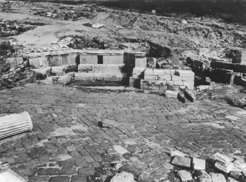 Figure 10
The podium of the Monument of Antonius, looking north Tsafrir and Foester (1997) |
Tsafrir and Foester (1997) |
| Nymphaeum - damaged in 363 but photo includes 749 collapse |
 Figure 11
The nymphaeum after the removal of the collapsed architectural members of the facade, looking southwest Tsafrir and Foester (1997) |
Tsafrir and Foester (1997) |
| Nymphaneum - damaged in 363 but photo includes 749 collapse |
 Figure 30
Byzantine building abutting the Roman colonnade opposite the nymphaeum, looking southwest. The Byzantine foundations are lower than those of the former Roman portico. Note the early Islamic provisional walls in front of the nymphaeum. Tsafrir and Foester (1997) |
Tsafrir and Foester (1997) |
| Front of Nymphaneum - Rubble from 749 Quake |
 Figure 12
Rubble from the earthquake of 749 C.E. in front of the nymphaeum, looking west Tsafrir and Foester (1997) |
Tsafrir and Foester (1997) |
| fallen superstructure of nymphaeum due to 749 |
 Figure 13
Architectural members of the superstructure of the nymphaeum as they fell in the earthquake of 749 C.E., looking south Tsafrir and Foester (1997) |
Tsafrir and Foester (1997) |
| Roman portico after reconstruction |
 Figure 14
The Roman portico after reconstruction, the decorative pool, and Silvanus Street during clearance of the rubble from the earthquake of 749 C.E., looking west. In the center are the Central Monument and the Monument of Antonius. Tsafrir and Foester (1997) |
Tsafrir and Foester (1997) |
| Palladius Street |
 Figure 15
Palladius Street (center) and the stairway of the Roman temple, with the two monolithic columns as collapsed in the earthquake of 749 C.E. (bottom left), looking southwest Tsafrir and Foester (1997) |
Tsafrir and Foester (1997) |
| Palladius Street and sigma |
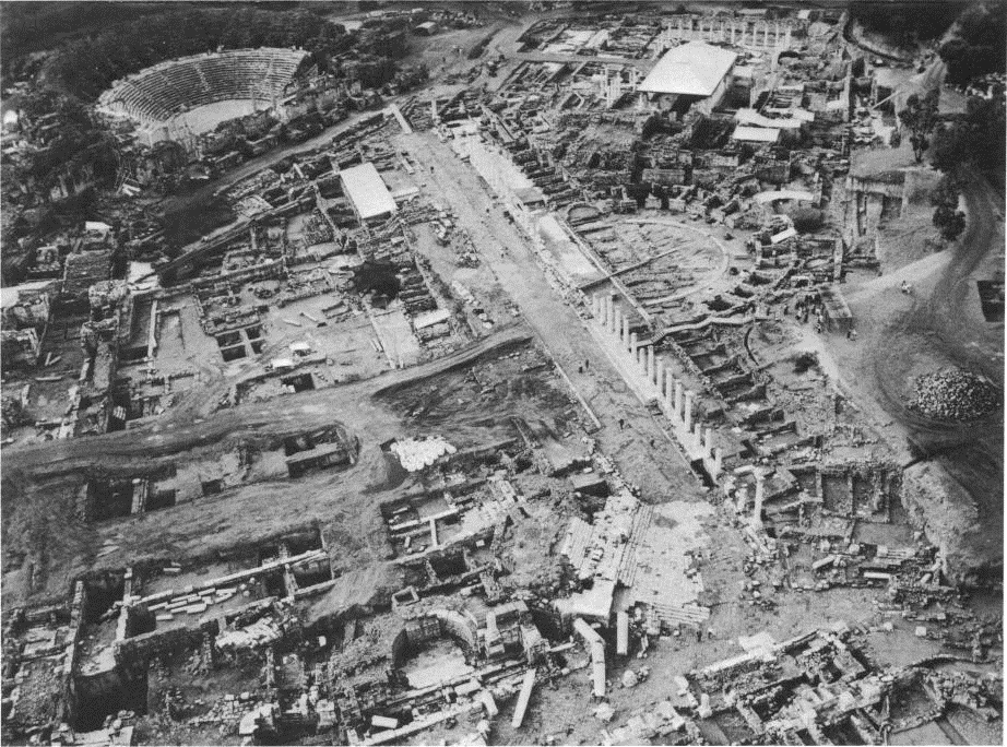 Figure 23
Palladius Street and the sigma, looking southwest. At the top are the theater and the western bathhouse, and at the bottom are the temple and the nymphaeum. Tsafrir and Foester (1997) |
Tsafrir and Foester (1997) |
| Palladius Street and the sigma |
 Figure 28
The sigma and Palladius Street, looking east. Note the area of the Byzantine agora southeast of the street (center). Tsafrir and Foester (1997) |
Tsafrir and Foester (1997) |
| Byzantine agora |
 Figure 31
The walls, stylobate, and oil-shale pavement of the Byzantine agora, looking north, On the right is the apse of the Roman basilica Tsafrir and Foester (1997) |
Tsafrir and Foester (1997) |
| Roman colonnade/Silvanus Street |
 Figure 32
The Roman colonnade after reconstruction, looking southeast. Lining it on the northeast are the Roman decorative pool (partially excavated) and Silvanus Street. The rubble for the earthquake of 749 CE and the Umayyad shops are preserved in the southeast (top). Tsafrir and Foester (1997) |
Tsafrir and Foester (1997) |
| Silvanus Street |
 Figure 33
Silvanus Street, the colonnade of the Roman portico, the decorative pool, and the partially reconstructed Umayyad shops, looking southwest Tsafrir and Foester (1997) |
Tsafrir and Foester (1997) |
| Roman colonnade |
 Figure 34
The Roman colonnade and the northeast wing of the eastern bathhouse (bottom), looking northeast. Between them are three columns of Silvanus Hall. Tsafrir and Foester (1997) |
Tsafrir and Foester (1997) |
| Collapsed Columns on Valley Street |
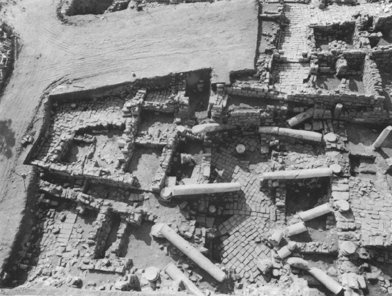 Figure 48
Columns collapsed on Valley Street in the earthquake of 749 C.E., looking southwest. Note the Umayyad walls that narrowed the street before the earthquake and the Abbasid building on top of the collapse (top right). Tsafrir and Foester (1997) |
Tsafrir and Foester (1997) |
| Umayyad pottery kiln - folded pavement and slumped wall |
 Figure 52
Umayyad pottery kiln installed on a mosaic floor of a Byzantine shop, south of Palladius Street Tsafrir and Foester (1997) |
Tsafrir and Foester (1997) |
| Collapsed facade of Umayyad shops on Silvanus Street |
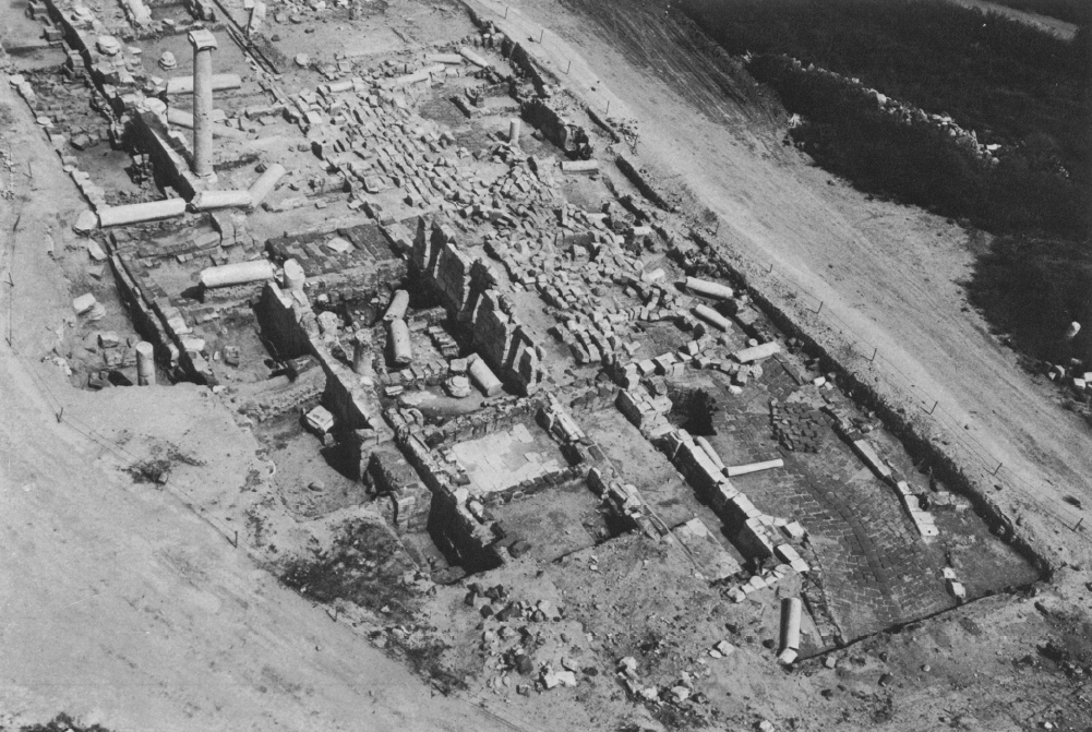 Figure 54
Silvanus Street during excavation and reconstruction, looking north. Note the collapse of the facade of the Umayyad shops and the arcade on the street Tsafrir and Foester (1997) |
Tsafrir and Foester (1997) |
| Rear wall of Umayyad shops on Silvanus Street |
 Figure 55
The rear wall of the Umayyad shops, blocking the Roman colonnade along Silvanus Street, looking northwest Tsafrir and Foester (1997) |
Tsafrir and Foester (1997) |
| Sunken pavement on Silvanus Street |
 Figure 56
Succession of layers near the southeast end of Silvanus Street, looking southeast. The lower courses of the facade of the Umayyad shops can be seen cutting the mosaic pavement of the earlier Silvanus Hall. The mosaic was laid on top of the rather loose soil and ashes with which the Roman pool had been filled, and which later sunk along with the mosaic. The steps on the edge of the pool are seen on the far end of the pool (top); their shape can also be discerned on the northeast (left) through the margins of the mosaic that remained on their original level. Tsafrir and Foester (1997) |
Tsafrir and Foester (1997) |
| Collapsed arcade of portico on Silvanus Street |
 Figure 57
Silvanus Street, the partially reconstructed facade of the Umayyad shops, and the arcade of the portico as collapsed in the earthquake of 749 C.E., looking northwest Tsafrir and Foester (1997) |
Tsafrir and Foester (1997) |
| Umayyad coin hoard from Silvanus Street |
 Figure 58
Umayyad gold dinars found in a shop near Silvanus Street, buried under the collapse of 749 C.E. Tsafrir and Foester (1997) |
Tsafrir and Foester (1997) |
| Silvanus Street during the removal of the rubble rom the earthquake of 749 C.E. |
 Figure 59
Silvanus Street during the removal of the rubble from the earthquake of 749 C.E., showing remains of the later line of Umayyad shops on the northwest side (left), looking southeast, and pedestals of the Roman colonnade before the anastylosis (right) Tsafrir and Foester (1997) |
Tsafrir and Foester (1997) |
| Fallen Columns near Nymphaneum (?) |
 Figure 10
‘The deafening roar of devastation’: fallen columns at the crossroads of Baysan; note the impact of the column on the street paving (Walmsley). Walmsley (2007) |
Walmsley (2007) |
| Pre and Post 749 levels at Valley Street |
Post-749 buildings at Baysān located above the earthquake destruction level of Valley Street (Fig. 4.4 [20]); the underlying destruction level can be seen on the left (Alan Walmsley). Blanke and Walmsley (2022) |
Blanke and Walmsley (2022) |
| Earthquake destruction |
 Scytholopolis (aka Bet She'an aka Baishan). JW: Much of this collapse is due to the January 749 CE Holy Desert Quake of the Sabbatical Year Sequence
Ori - Wikipedia - Attribution only license - an instance of free license |
Wikipedia |
- Photo 3.59 General view
of Stratum R-2 Temple 58066 from Mazar and Mullins (2007)
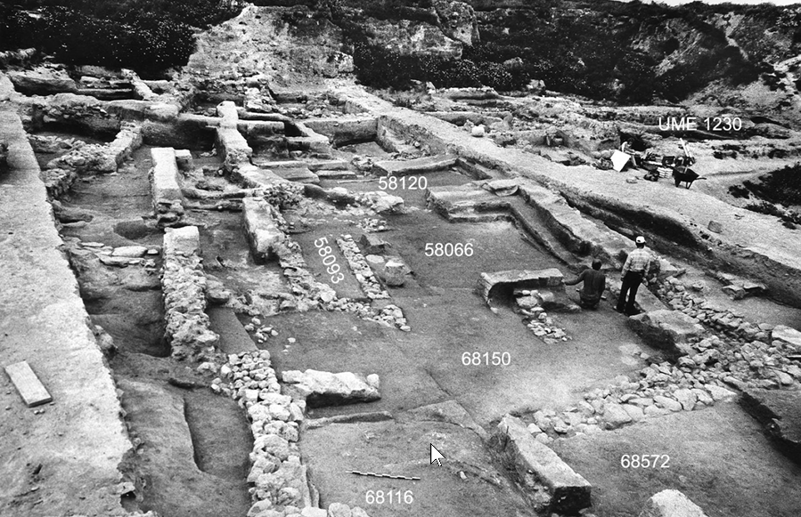 Photo 3.59
General view of Stratum R-2 Temple 58066.Looking north (1990)
Click on image to open in a new tab
Mazar and Mullins (2007) - Photo 3.61 southeastern
corner of Temple 58066 from Mazar and Mullins (2007)
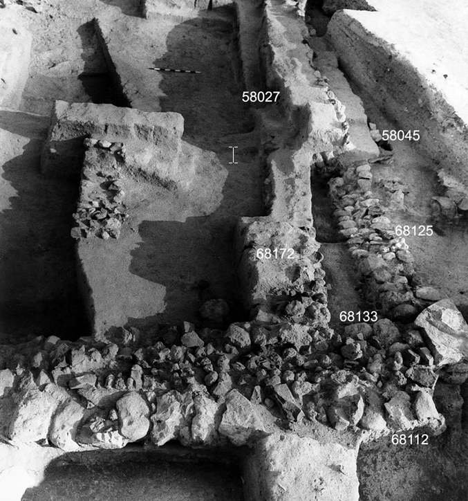 Photo 3.61
Squares N/56. The southeastern corner of Temple 58066. Looking north (1990)
Click on image to open in a new tab
Mazar and Mullins (2007) - Photo 3.62 eastern part
of Temple 58066 from Mazar and Mullins (2007)
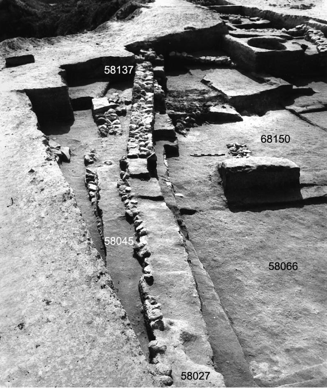 Photo 3.62
Temple 58066, eastern part. Notice Stratum R-1b Wall 58137 overlying Stratum R-2 Wall 58027. Looking south (1990) Looking north (1990)
Click on image to open in a new tab
Mazar and Mullins (2007) - Photo 3.68 sagging and
tilting Bench 58048 of Temple 58066 from Mazar and Mullins (2007)
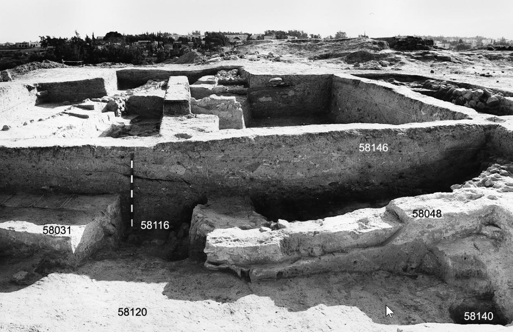 Photo 3.68
Temple 58066 during excavation, before removal of balks. Foreground: detail of the entrance area to Inner Hall 58120. Stratum R-2’ Pit 58146 is above Bench 58048. Notice the angle of Bench 58048, probably a result of seismic activity. Looking south (1989)
Click on image to open in a new tab
Mazar and Mullins (2007)
- Photo 3.59 General view
of Stratum R-2 Temple 58066 from Mazar and Mullins (2007)
Photo 3.59
General view of Stratum R-2 Temple 58066.Looking north (1990)
Click on image to open in a new tab
Mazar and Mullins (2007) - Photo 3.61 southeastern
corner of Temple 58066 from Mazar and Mullins (2007)
Photo 3.61
Squares N/56. The southeastern corner of Temple 58066. Looking north (1990)
Click on image to open in a new tab
Mazar and Mullins (2007) - Photo 3.62 eastern part
of Temple 58066 from Mazar and Mullins (2007)
Photo 3.62
Temple 58066, eastern part. Notice Stratum R-1b Wall 58137 overlying Stratum R-2 Wall 58027. Looking south (1990) Looking north (1990)
Click on image to open in a new tab
Mazar and Mullins (2007) - Photo 3.68 sagging and
tilting Bench 58048 of Temple 58066 from Mazar and Mullins (2007)
Photo 3.68
Temple 58066 during excavation, before removal of balks. Foreground: detail of the entrance area to Inner Hall 58120. Stratum R-2’ Pit 58146 is above Bench 58048. Notice the angle of Bench 58048, probably a result of seismic activity. Looking south (1989)
Click on image to open in a new tab
Mazar and Mullins (2007)
- Photo 4.1 General view
of Area S from Panitz-Cohen and Mazar (2009:95)
 Photo 4.1
General view of Area S, looking south.
- Right: north–south street
- Center: east–west street
- Background: Roman Byzantine remains south of the tell
(1994)
Panitz-Cohen and Mazar (2009:95) - Photo 4.51 Human remains
in Stratum S-4 from Panitz-Cohen and Mazar (2009:95)
 Photo 4.51
Square B/7, S-4 Locus 18714. Remains of human skeleton in situ
Panitz-Cohen and Mazar (2009:95) - Photo 4.52 Human remains
in Stratum S-4 from Panitz-Cohen and Mazar (2009:95)
 Photo 4.52
Square Y/7, S-4 Locus 10743, looking southwest. Remains of human skeleton in situ
Panitz-Cohen and Mazar (2009:95) - Photo 4.34 Sloping foundation
from Panitz-Cohen and Mazar (2009)
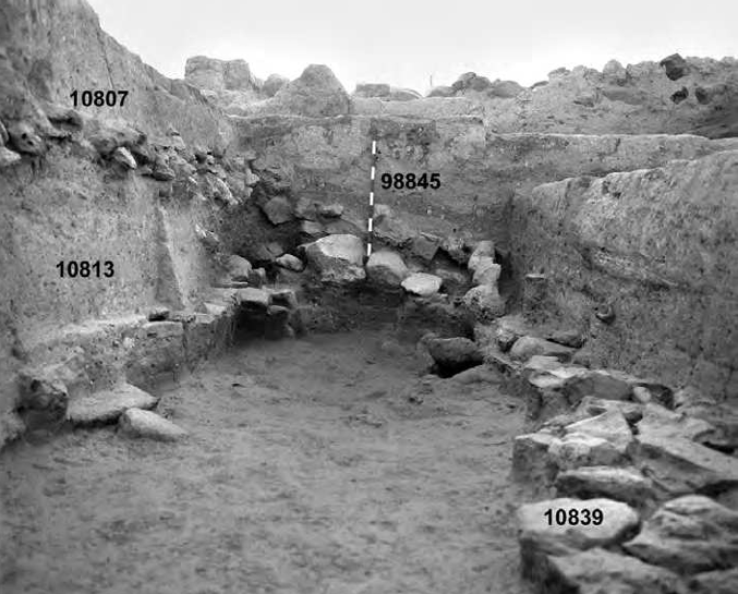 Photo 4.34
S-3 Building SH above S-4 Building SC, looking west. Note sloping stone foundation of Wall 98845 above large S-4 stones
Panitz-Cohen and Mazar (2009) - Photo 4.71 Stratum-3 Building SL
from Panitz-Cohen and Mazar (2009)
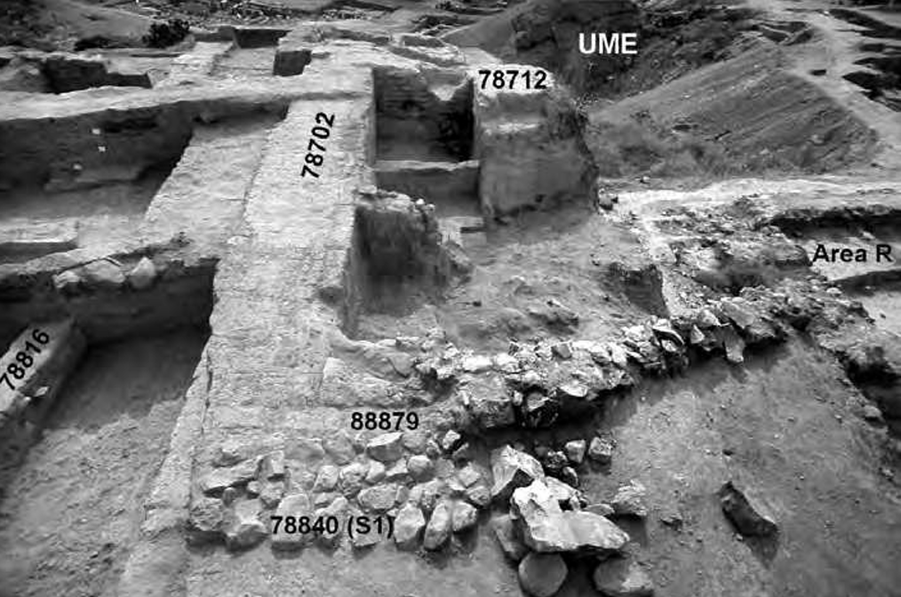 Photo 4.71
S-3 Building SL, looking south. Left: northsouth street. Upper right: UME trench. Lower right: Area R (1994)
Click on image to open in a new tab
Panitz-Cohen and Mazar (2009) - Photo 4.72 Stratum-3 Building SL
from Panitz-Cohen and Mazar (2009)
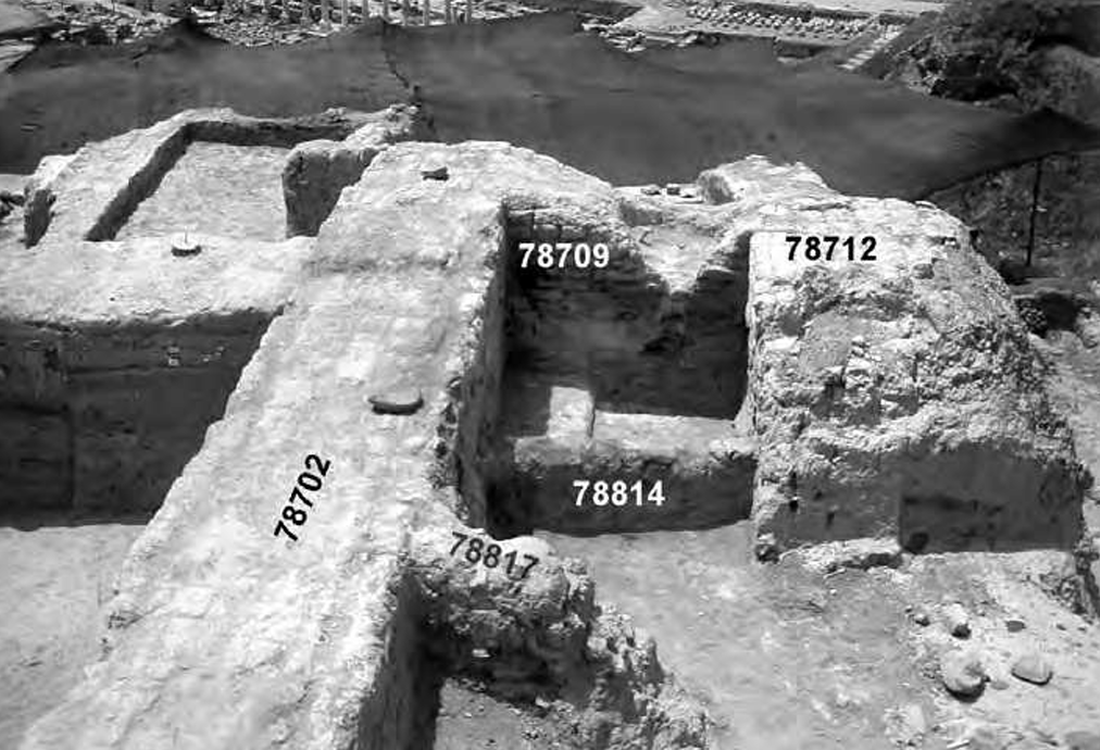 Photo 4.72
S-3 Building SL, southern end, looking south. S-2 Walls 78814 and 78817 built into center of building. Accumulated layers in north–south street visible in the section to the left of Wall 78702
Click on image to open in a new tab
Panitz-Cohen and Mazar (2009) - Photo 4.74 General view of
southern part of Area S from Panitz-Cohen and Mazar (2009)
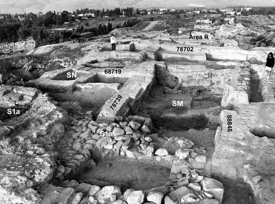 Photo 4.74
General view of southern part of Area S, looking west. Right center: Building SM. Left center: Building SN. Foreground: S-1a building. Background: modern town of Beth-Shean
Click on image to open in a new tab
Panitz-Cohen and Mazar (2009) - Photo 4.75 Stratum-3 Buildings
SM and SN from Panitz-Cohen and Mazar (2009)
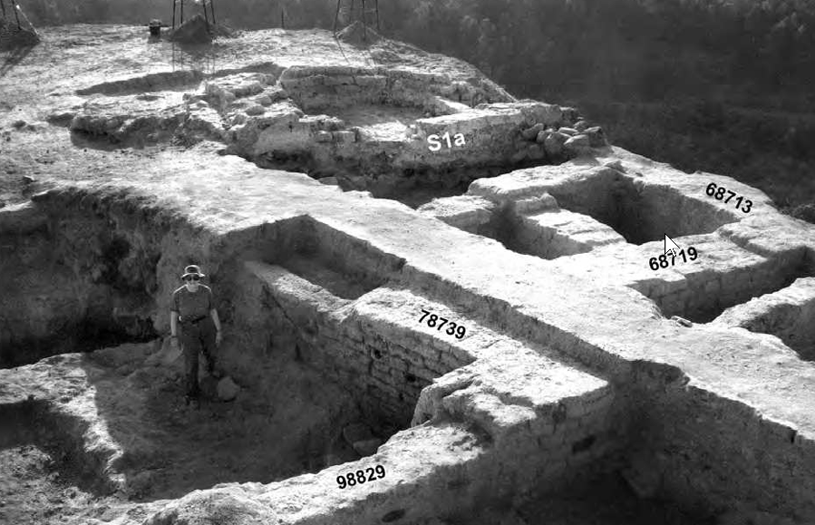 Photo 4.75
S-3 Buildings SM (left) and SN (right), looking southeast. Woman standing on destruction debris 78737 in Space 88700, Building SM. Background: S-1a building (1990)
Click on image to open in a new tab
Panitz-Cohen and Mazar (2009) - Photo 4.76 Stratum-3 Building
SM with Wall 78739 from Panitz-Cohen and Mazar (2009)
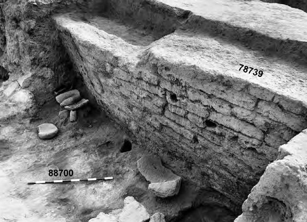 Photo 4.76
S-3 Building SM, looking southeast. Wall 78739 and grindstones on Floor 88700 (1990)
Click on image to open in a new tab
Panitz-Cohen and Mazar (2009) - Photo 4.77 Stratum-3 Building
SM southwestern corner of Space 88700 from Panitz-Cohen and Mazar (2009)
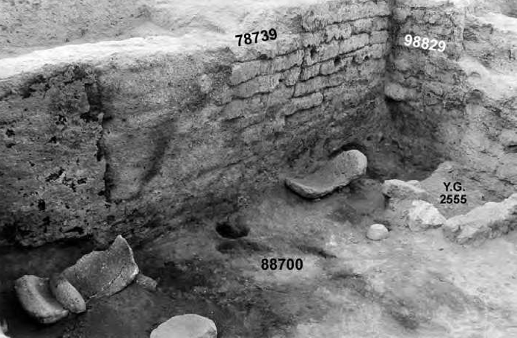 Photo 4.77
S-3 Building SM, southwestern corner of Space 88700. Right: Yadin and Geva’s Bin 2555 (1990)
Click on image to open in a new tab
Panitz-Cohen and Mazar (2009) - Photo 4.78 Stratum-3 Building
SM from Panitz-Cohen and Mazar (2009)
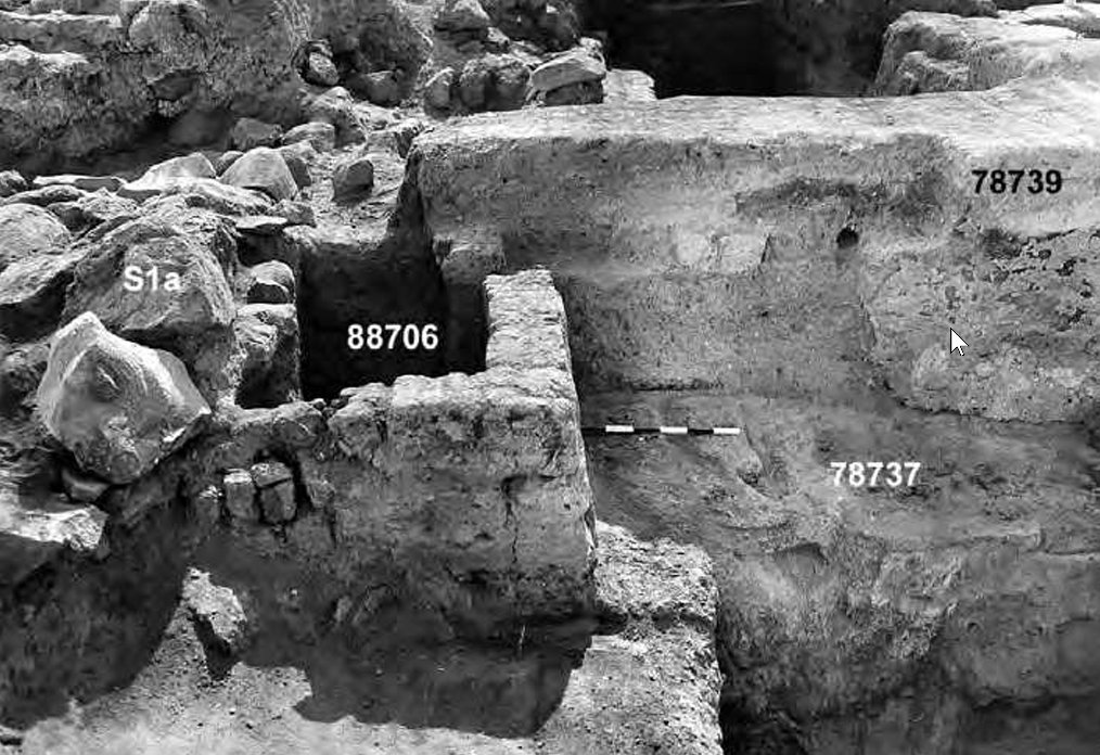 Photo 4.78
S-3 Building SM, southeastern part, looking south. Left: stone foundations of S-1a building cutting into S-3 remains (1991)
Click on image to open in a new tab
Panitz-Cohen and Mazar (2009) - Photo 4.79 Stratum-3 Building
SM and Space 88700 from Panitz-Cohen and Mazar (2009)
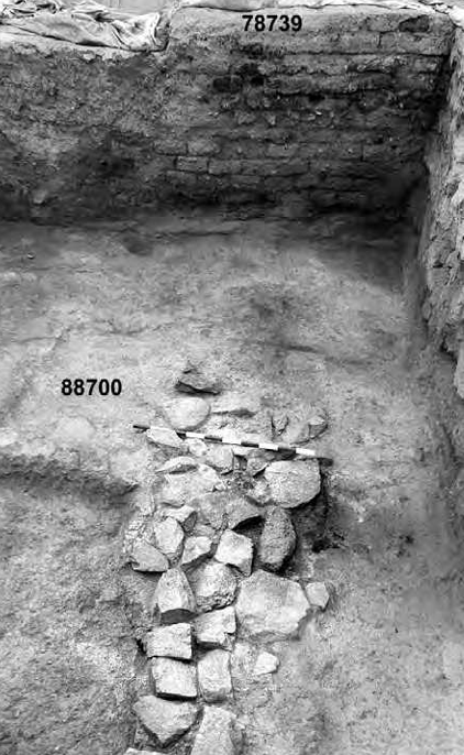 Photo 4.79
S-3 Building SM, looking south. Stone pavement in western part of Space 88700 (1992)
Click on image to open in a new tab
Panitz-Cohen and Mazar (2009)
- Photo 4.1 General view
of Area S from Panitz-Cohen and Mazar (2009:95)
Photo 4.1
General view of Area S, looking south.
- Right: north–south street
- Center: east–west street
- Background: Roman Byzantine remains south of the tell
(1994)
Panitz-Cohen and Mazar (2009:95) - Photo 4.51 Human remains
in Stratum S-4 from Panitz-Cohen and Mazar (2009:95)
Photo 4.51
Square B/7, S-4 Locus 18714. Remains of human skeleton in situ
Panitz-Cohen and Mazar (2009:95) - Photo 4.52 Human remains
in Stratum S-4 from Panitz-Cohen and Mazar (2009:95)
Photo 4.52
Square Y/7, S-4 Locus 10743, looking southwest. Remains of human skeleton in situ
Panitz-Cohen and Mazar (2009:95) - Photo 4.34 Sloping foundation
from Panitz-Cohen and Mazar (2009)
Photo 4.34
S-3 Building SH above S-4 Building SC, looking west. Note sloping stone foundation of Wall 98845 above large S-4 stones
Panitz-Cohen and Mazar (2009) - Photo 4.71 Stratum-3 Building SL
from Panitz-Cohen and Mazar (2009)
Photo 4.71
S-3 Building SL, looking south. Left: northsouth street. Upper right: UME trench. Lower right: Area R (1994)
Click on image to open in a new tab
Panitz-Cohen and Mazar (2009) - Photo 4.72 Stratum-3 Building SL
from Panitz-Cohen and Mazar (2009)
Photo 4.72
S-3 Building SL, southern end, looking south. S-2 Walls 78814 and 78817 built into center of building. Accumulated layers in north–south street visible in the section to the left of Wall 78702
Click on image to open in a new tab
Panitz-Cohen and Mazar (2009) - Photo 4.74 General view of
southern part of Area S from Panitz-Cohen and Mazar (2009)
Photo 4.74
General view of southern part of Area S, looking west. Right center: Building SM. Left center: Building SN. Foreground: S-1a building. Background: modern town of Beth-Shean
Click on image to open in a new tab
Panitz-Cohen and Mazar (2009) - Photo 4.75 Stratum-3 Buildings
SM and SN from Panitz-Cohen and Mazar (2009)
Photo 4.75
S-3 Buildings SM (left) and SN (right), looking southeast. Woman standing on destruction debris 78737 in Space 88700, Building SM. Background: S-1a building (1990)
Click on image to open in a new tab
Panitz-Cohen and Mazar (2009) - Photo 4.76 Stratum-3 Building
SM with Wall 78739 from Panitz-Cohen and Mazar (2009)
Photo 4.76
S-3 Building SM, looking southeast. Wall 78739 and grindstones on Floor 88700 (1990)
Click on image to open in a new tab
Panitz-Cohen and Mazar (2009) - Photo 4.77 Stratum-3 Building
SM southwestern corner of Space 88700 from Panitz-Cohen and Mazar (2009)
Photo 4.77
S-3 Building SM, southwestern corner of Space 88700. Right: Yadin and Geva’s Bin 2555 (1990)
Click on image to open in a new tab
Panitz-Cohen and Mazar (2009) - Photo 4.78 Stratum-3 Building
SM from Panitz-Cohen and Mazar (2009)
Photo 4.78
S-3 Building SM, southeastern part, looking south. Left: stone foundations of S-1a building cutting into S-3 remains (1991)
Click on image to open in a new tab
Panitz-Cohen and Mazar (2009) - Photo 4.79 Stratum-3 Building
SM and Space 88700 from Panitz-Cohen and Mazar (2009)
Photo 4.79
S-3 Building SM, looking south. Stone pavement in western part of Space 88700 (1992)
Click on image to open in a new tab
Panitz-Cohen and Mazar (2009)
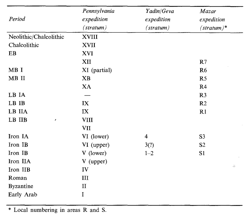
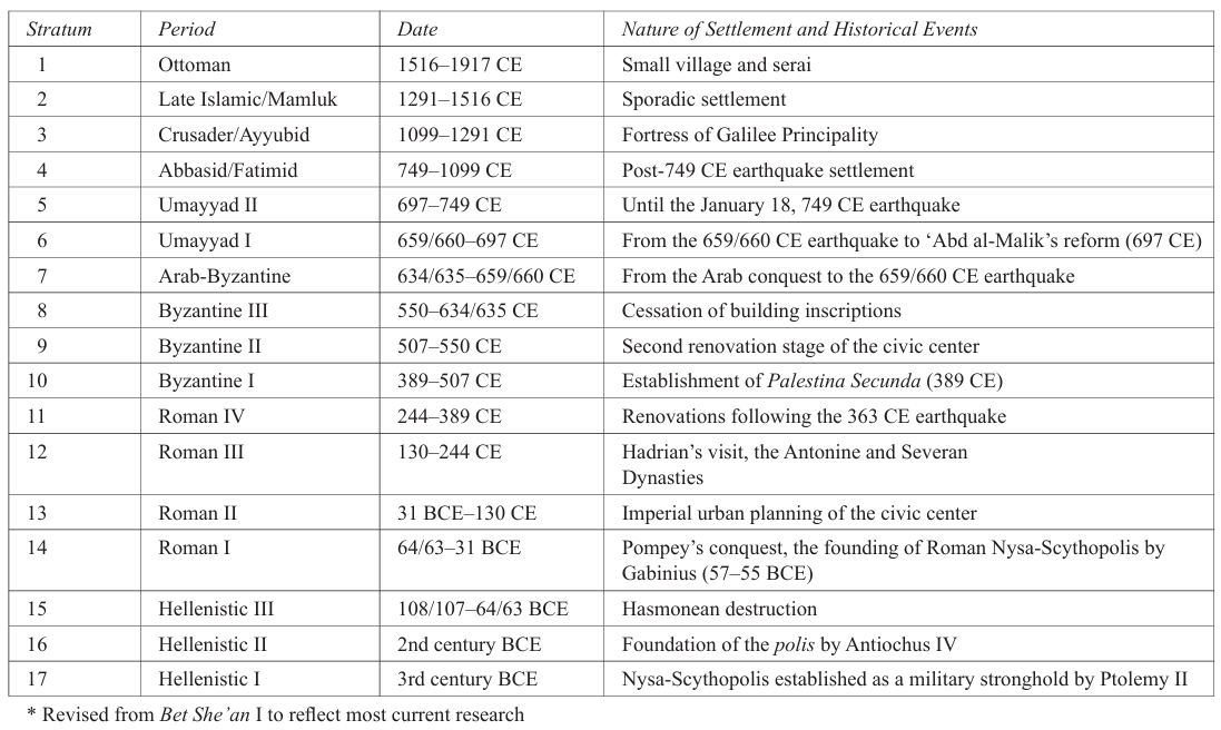 The Bet She’an Archaeological Project Chronological Chart
Bar-Nathan and Atrash (2011)
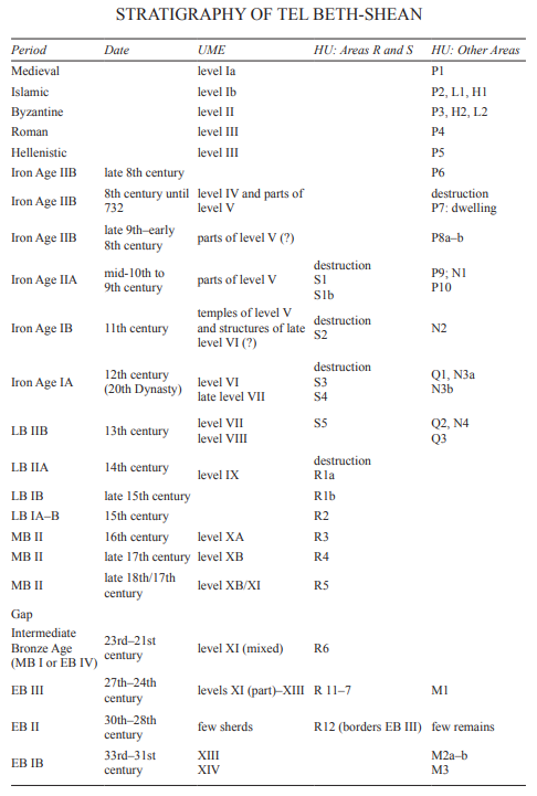 Stratigraphy of Tel Beth-Shean - This chart presents the University Museum of the University
of Pennsylvania Expedition (UME) strata and local stratigraphy in the
Hebrew University (HU) excavations at Tel Bet-Shean
Stratigraphy of Tel Beth-Shean - This chart presents the University Museum of the University
of Pennsylvania Expedition (UME) strata and local stratigraphy in the
Hebrew University (HU) excavations at Tel Bet-SheanStern et. al. (2008)
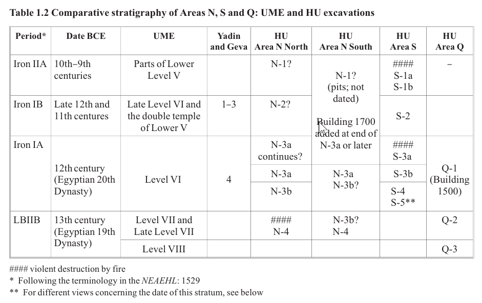 Table 1.2
Comparative stratigraphy of Areas N, S and Q: UME and HUexcavations
Mazar in Panitz-Cohen and Mazar (2009)
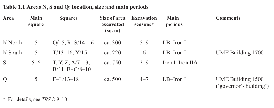 Table 1.1
Comparative stratigraphy of Areas N, S and Q: UME and HU excavations
Mazar in Panitz-Cohen and Mazar (2009)
 Table 4.1
Correlation of the stratigraphy of Area S
Panitz-Cohen and Mazar (2009)
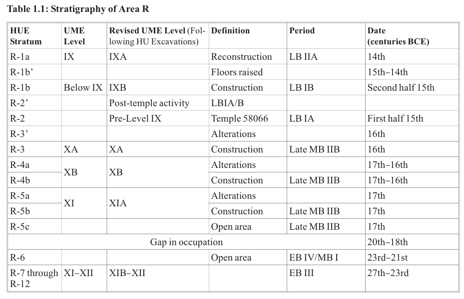
 Table 1.2
Old and New Strata Numbers in Area R
Mazar and Mullins (2007)
- Fig. 3.37
- Squares L/9–10 Looking west
Figure 3.29Location of stratigraphic sections: central and western part of Area R
Click on image to open in a new tab
Mazar and Mullins (2007)
Figure 3.37Section 7a (Sq. L/9-10, looking west)
Click on image to open in a new tab
Mazar and Mullins (2007)
The deepest point in Area R was reached in Squares L/9–10, where well-stratified remains from Stratum R-12 (EB III) were uncovered. This section illustrates well the compressed nature of the stratigraphy here since the depth of deposit is only 3.8 m from Stratum R-12 (EB III) to Stratum R-1a (LB IIA); and just over 1.5 m of this total depth belongs to the six EB III phases (Strata R-12–R-7)!
Four distinct surfaces of Stratum R-5 are visible between 87.7–88 m. In Square L/10, Floor 88320 (a composite stone and beaten-earth surface) abuts Stratum R-5 Wall 98301 on the north, while Floor 88326 — covered by ash debris (88325) and fragments of a broken MB II storage jar — meets it on the south. In Square L/9, Floor 98318 (clearly below R-4 walls) abuts R-5 Wall 98321. Floor 88317 is slightly higher and was poorly preserved in section, but its relationship to Wall 98321 and its stratigraphic position below Stratum R-4 are clear.
In Square L/10, Stratum R-4 comprises R-4b Floor 88314 covered by a thick ash deposit. Floor 88315 is puzzling, as it seems to belong to Stratum R-4b, but lies at a lower elevation than Floor 88314. The only explanation is the general dislocation and sloping of floors eastward towards the oval crater throughout this area as a result of seismic activity. The only R-4a feature in this square is Floor 78311, which extends above the Stratum R-4b destruction (78314). In section, it is hard to say whether this pink-plaster floor is R-4a or R-3, since its relationship to R-3 Wall 68309 is unclear. On the other side of the “bend” in Square L/9 are two Stratum R-4 walls one above the other — 98320 (R-4b) and 78312 (R-4a). The perspective here is of both walls running into the balk at an angle (Figs. 3.3, 3.4). R-4b Surface 78119 abuts the southeastern face of Wall 98320, but then peters out to reappear again in Square L/8 (see Section 7b). Only a short segment of R-4a Floor 78115 is visible in the section at the point where it abuts the southern side of Wall 78312.
In Stratum R-3, two east–west walls protrude from the balk in Square L/10: 68309 and 68318. Floor 68312 abuts the northern face of 68309, while Floor 78309 on the southern side tips up to it and is clearly bonded to Wall 68318. Overlying this floor is an accumulation of ash and charcoal (78307). A later R-3’ lime-plaster floor (68304) shows the clearest connection between the two R-3 walls. Above Floor 68304 are four stones that were possibly thrown in as part of a leveling fill for Stratum R-1b. In Square L/9, R-3 Floor 78101 most probably related to Wall 68318 on the north — a surface which is just centimeters below R-1b Walls 68308 and 68307.
Stratum R-1 is represented by three walls that partly cut into earlier R-3 features. No evidence for Stratum R-2 was found here apart from Wall 58042 in Square L/10. R-1a Floor 68301 (UME 1385) extends from the northern balk in Square L/10 across the highest point of the western section. Most likely, this floor continued southwards to meet Wall 58042. Stratum R-1a layers south of Wall 58042 were removed by the UME. No Stratum R-1b floors are visible in this square.
In Square L/9, R-1b Wall 68308 cuts deeply into R-3 layers. Floor 68306a bonds with Wall 68308 in the north and probably met Wall 68307 in the south. Two additional R-1b surfaces (68311b and 68311a) continue southwards from this wall into Square L/8 to meet R-1b Wall 68319 (Section 7b).
- Fig. 3.42
- Square L/9 Looking south
Figure 3.29Location of stratigraphic sections: central and western part of Area R
Click on image to open in a new tab
Mazar and Mullins (2007)
Figure 3.42Section 10 (Sq. L/9, looking south)
Click on image to open in a new tab
Mazar and Mullins (2007)
The angle of Stratum R-3 Wall 78339 and R-3 Floor 78101 abutting it on the west, both of which lie upon layers of Strata R-4–R-5, indicate that they slid into the depression, probably as a result of settling or earthquake activity.
Above the Stratum R-3 wall and below R-2 Temple Wall 58128 is a 0.1–0.15-m-thick layer that rises over the hump of Wall 78339 and then drops into the crater. This layer has three possible interpretations: (1) an abandonment layer between Strata R-3 and R-2, evident only here; (2) a leveling fill for the R-2 temple that eventually sank when the earthquake struck, probably during the lifetime of Stratum R-2; (3) an unknown cause. It is worthwhile noting in regard to the first interpretation, that there is no indication of a long break between the end of Stratum R-3 and the beginning of R-2 in the south (see also Section 14).
- Fig. 3.43
- Squares L–M/9–10 Looking east
Figure 3.29Location of stratigraphic sections: central and western part of Area R
Click on image to open in a new tab
Mazar and Mullins (2007)
Figure 3.43Section 11 (Sq. M/9-10, looking east)
Click on image to open in a new tab
Mazar and Mullins (2007)
As in the case of Section 10, the EB levels are reasonably horizontal while the MB layers are all sloping. The southernmost edge of the EB settlement in this area appears to have been disturbed from higher up. There are two possible causes for this: (1) the oval crater originated in MB, cutting through and partially damaging earlier EB features; (2) the oval crater originated with the EB settlement, but over time, as the accumulation of later MB debris continued and the edges of the crater receded back, it also eroded and damaged the underlying EB layers. This latter possibility might explain what appears to be mudbrick collapse from MB structures onto the 20-degree slope above EB III Wall 28321 at the bottom of the trench in Square L/9.
MB II layers such as Stratum R-4b Floor 88318 in Square M/10 are horizontal in the north, but when the edge of the crater is reached, fall into it. The same is true for R-4a Floor 78308 and R-3 Stone Pavement 78321 above. R-3 Wall 68309 to the south has partly fallen into the oval crater, although the R-3 piazza surface (78322) is still located as high as Stone Pavement 78329 to its north. Further to the south, however, the R-3 piazza (98303 in Square M/9) dips into the oval crater, probably as a result of later settling or seismic activity. Walls 58095 and 58042 (Square M/9) have deep foundations that practically rest on R-3 Floor 98303. Strata R-2–R-1 layers in Square M/10 were not drawn.
Seven radiocarbon dates from two contexts in Areas N North and S were measured in 1998 by Israel Carmi at the radiocarbon laboratory of the Weizmann Institute of Science, Rehovot, using liquid scintillation counters (Mazar and Carmi 2001). Table 1.4 cites these dates, Fig. 1.6 shows a group plot of all these dates, and Figs 1.7–1.8 show the results of the Combine function of OxCal software, where averages of the calibrated dates of each group are shown.11 The alternative R-Combine (calibrated calculated averages of all BP dates from a single context) provided similar dates to those of the Combine function and thus is not included here.
The three dates from Area N were measured on samples of charred grain from the two storage chambers in Stratum N-4 Building NB (Chapter 2), each of which contained large amounts of grain in a well-defined stratigraphic and architectural context that was destroyed by fire. The four dates from Area S were measured on a cache of over half a million flaxseeds from Stratum S-3a Installation 28817 (Chapter 4), which is also a secure, sealed context. One of the samples from Area S also included some charred wood.
 Table 1.4
Radiocarbon dates from Areas N and S calibrated with OxCal 3.10 software
Panitz-Cohen and Mazar (2009)
Two of the three dates from Stratum N-4 do not predate 1200 in the 68% probability range, while the 95% probability range includes much of the 13th century as well. The lower dates are in the late 12th and 11th centuries and the combined average of the calibrated dates is 1210–1125 in the 68.2% probability range. Based on archaeological considerations, the end of Stratum N-4 was dated to the late 13th or very early 12th centuries, and this date can be supported by the radiocarbon dates in the 68% probability range. The end of Stratum S-3a is related to the end of the Egyptian presence in Canaan during the time of Ramesses IV or V, 1140/30. Three of the four dates from Stratum S-3a can support such a date in the 68% probability range and all four cover this period in the 95% probability range. The combined calibrated date in the 68.2% probability range is 1195–1120, and thus fits the archaeological/historical date.
The problem with this data is that there is an almost total overlap between the calibrated dates of the combined dates of the two groups, in spite of the fact that they are three stratigraphic phases apart (on the difficulties in using radiocarbon dates for ca. 1200, see Manning 2007). Thus, on the one hand, the radiocarbon dates support the archaeological/historical dates, while on the other hand, they fail to enable a refined sequence of absolute dating which would be supported by the stratigraphic sequence.
 Figure 1.6
Group plot of all dates from Strata N-4 and S-3a (see Table 1.4)
Plot prepared with OxCal 3.10 software
Panitz-Cohen and Mazar (2009)
 Figure 1.7
Combined dates of the three samples from Stratum N-4
prepared with OxCal 3.10 software
Panitz-Cohen and Mazar (2009)
Figure 1.8Combined dates of the four samples from Stratum S-3a
prepared with OxCal 3.10 software
Panitz-Cohen and Mazar (2009)
Area S is located in the southeastern corner of the summit of Tel Beth-Shean, overlooking the entire Beth-Shean Valley (Photos 1.1, 4.1). The area is limited on the south and west by cliffs created by the previous excavations and on the east by a steep slope separating the summit of the tel from its lower eastern terrace. In the northeast of the area (Squares Y/9–10) a very large pit, apparently dating to the Byzantine Period, cut the early structures. The area had been previously excavated by the UME (1921 1933), which completely removed most of the upper five strata from the summit (James 1966). In 1983, Yigael Yadin and Shulamit Geva conducted a limited excavation in the center of this area, located in our Squares Z–B/8–9 (Yadin and Geva 1986).
Our excavations in Area S continued for eight seasons, each lasting six weeks: February 1990, September–November 1990, October–November 1991, July–August 1992, July–August 1993, June July 1994, June–July 1995 and June–July 1996. During the first two seasons, the excavation was limited to Squares Y–A/7 (total of 75 sq. m), south of Yadin and Geva’s excavation area. In the following seasons, the area was extended to include Squares Y–C/6–11. During the 1995 season, the excavation was limited to Squares Y/10–11 and Z/Y–8. In 1996, the area was extended to the north (parts of Squares T–B/12–13), thus creating a connection with Area N North (Chapter 2).1 Since the Fall 1990 season, the area was divided into two parts, each supervised independently: Area SA was the southern part and Area SB was the northern part (from the east–west street in Squares Z–C/9–10 northwards, with few exceptions in some of the seasons). In the present text, the designations ‘SB’and ‘SA’are not used and the entire area is referred to as Area S. All in all, 28 squares were excavated, covering a total area of 700 sq. m.
The following staff members supervised the work in this area:
Area SA. Winter 1990: Ray Bellamy and Efrat Assaf, assisted by Garth Gilmour. Fall 1990, 1991, 1992: Yoni Rand and Dalit Weinblatt, assisted by Jill Avrais. 1993, 1994: Anat Cohen-Weinberger, assisted by Eduarda Morris.
Area SB. 1990, 1991, 1992, 1993, 1994 and part of 1995: Nava Panitz-Cohen, assisted by Anat Cohen Weinberger (1991, 1992); Nir Papai (1993); Linda Bregstein-Scherr (1994); Eduarda Morris (1995); part of 1995: Anat Cohen-Weinberger, assisted by Eduarda Morris. 1996: Robert Mullins.
In this area, the UME removed all remains of their Level IV and much of Level V. The extant finds of the latter that we were able to recover were denoted by us Stratum S-1a andS-1b,dating to Iron Age IIA. The main remains from these levels belong to four structures that we termed Buildings A–D in Stratum S-1a (published in TBS I: 173 201). Our excavations commenced partially from the UME Level Lower V (our Stratum S-1a), partially from UME Late Level VI (our Stratum S-2), and in other places from Yadin and Geva’s Stratum 4 (paralleled to UME Level VI and our Stratum S 3). In most of Area S, the excavation ended on floor levels of our Stratum S-4, which most probably corresponds to an early phase of UME Level VI. In very limited areas, our excavation reached Stratum S-5, which might correspond to Level VI (early) of UME, or possibly with Late Level VII (see further discussion of the stratigraphic correlation in Chapter 1).
Thanks to a strategy of opening large excavation areas, we managed to uncover sufficient structural remains and floor levels to enable an accurate reconstruction of the settlement history of this area in the 12th–11th centuries BCE. As will be seen below, our results differ from those of Yadin and Geva on several important points.
In the preliminary report, a tentative correlation between our local strata and those of the UME and Yadin was suggested (Mazar 1993). This correlation, however, is not always straightforward due to the ambiguity involved in the attribution of various structures found by the UME to Late Level VI and Lower Level V. Difficulties in correlation to Yadin and Geva’s stratigraphy are due to our different understanding of their Strata 1–3; see also Chapter 1. Table 4.1 shows our updated correlation.
Stratum S-3 was further subdivided into two sub-phases, S-3a and S-3b (‘a’ being the later phase) due to different building phases that were defined in certain locales. The sub-phases refer to local re-builds and architectural changes, while the main strata numbers refer to more substantial changes which occurred in the entire excavated area.
Table 4.1Correlation of the stratigraphy of Area S
Panitz-Cohen and Mazar (2009)
The goals of excavation in Area S were:
- To identify any remains of the uppermost strata (UME Level V and Yadin and Geva’s Stratum 1) possibly left by the previous expeditions, as well as uncovering additional remains from this occupation.
- To clarify plans of complete architectural units, as well as defining a town plan of building layout and streets during the various strata. 3. To incorporate the previously excavated remains into a coherent plan with the results of the present excavation.
- To isolate the material culture of each identified stratum and sub-phase, with the ultimate purpose of reconstructing the sequence of occupation in correlation with absolute dates based on the finds.
- To study the nature of the material culture at the time of the transition from the Late Bronze to the Iron Ages.
- plans: Figs. 4.4–4.7
- sections: Figs. 4.13–4.17
- pottery: Pls. 38–68
- plans:Figs. 4.5a, 4.6a
- sections: Figs. 4.21–4.22
- Photos 4.58–4.62
- pottery: Pls. 39–42:4
This building, located in Squares Z–B/10, was a rebuild of Stratum S-4 Building SC. It comprised a slightly trapezoid room, 3.1–3.7 m wide and 6.3 m long, delineated by Walls 88836 on the north and 88837 on the east, both continuing from S-4 and both part of the units to the north and east, described above. However, the southern wall of this room in S-4, Wall 10813, was now replaced by a new wall (10807), which was built with a stone socle almost exactly above the line of Wall 10813 (Photos 4.32–4.33). The western border of the room was red brick Wall 98845, whose stone socle was laid just above the concentration of stones found at the western end of S-4 pavement 10839 (Photo 4.34). This stone socle sloped sharply down from south to north (0.4 m over a distance of 3.8 m), perhaps a result of seismic activity or due to the natural topography. The red bricks and constructional technique of Wall 98845 are identical to that of Walls 98844, 98828, 28823 and 28851; see also Stratum N-3 Wall 10254 in Area N South (Chapter 3).
Photo 4.34S-3 Building SH above S-4 Building SC, looking west. Note sloping stone foundation of Wall 98845 above large S-4 stones
Click on image to open in a new tab
Panitz-Cohen and Mazar (2009:95)
The easternmost socle stones of Wall 10807 bonded with the bricks of Wall 88837 just above the upper tier of S-4 Installation 10824 (Photo 4.35). The stone socle continued to the east to join with that of Wall 88838 in Square B/9, attesting that both walls were actually built as a single long wall, although the eastern unit and the western unit appear to have been totally independent during S-3.
Stratum S-3b (plan: Fig. 4.5a). Above the S-4 striations (10830) in this room was a similar accumulation (Photo 4.59). The lowest layer was attributed to S-3b and was comprised of ca. 30 cm thick reddish clay and grey ash striations (10809) that abutted a small, densely-set basalt stone pavement (10819, 92.20 m) in the northeastern corner of the room. The southernmost stones of this floor covered the upper tier of S-4 Installation 10824. A rectangular brick bin (88846, inner dimensions: 0.9×1.3 m), preserved one course high, was built on top of this pavement; inside the bin was a concentration of burnt grain (Photo 4.58). West of the bin and the stone pavement was a north–south row of three flat-topped stones; the middle one served as the base of a small, round ashy fire pit, while the other two appear to have been pillar bases, perhaps used to roof the bin. An ashy surface (10802) which was related to the fire pit, abutted Bin 88846. An oven (10806) was found in the northwestern corner of this room, abutted by the striations (10809). The eastern part of this oven was cut by Pit 98851, which apparently was dug between S-3b and S-3a (Photo 4.59).
Stratum S-3a (plan: Fig. 4.6a). A new floor (88835) which sloped down from west to east (92.94–92.50 m) was laid in this room. This white lime floor, which covered the S-3b accumulation, had been originally exposed as Locus 2453 by Yadin and Geva (1986: 45–48), who excavated the southeastern part of this room. The present excavation extended the area, exposing Walls 88836 and 98845 which enclosed the unit on the north and west. Floor 88835 also covered the southern part of S-3b Bin 88846, which was now replaced by two smaller adjoining bins (Yadin and Geva’s 2547 and 2558, our 88882 and 88883) built along the southern face of Wall 88836. The narrow partition wall dividing these bins was actually a continuation of the wall of the S-3b bin below. These bins were full of wheat and barley (Yadin and Geva 1986: 46).
Additional installations found on Floor 88835 were:
- a plastered square installation in the southeastern corner of the room, termed a “doughing trough” (Yadin and Geva 1986: 46, Locus 2451)
- scanty traces of a square bin attached to Wall 10807 (ibid.: 46–47, Locus 2459). Note the similarity of this bin to 88844, found north of Wall 88836 in S-3a Room 88861
- an oven (10818) and some kind of cooking(?) installation (10820) adjacent to it, composed of a basalt quern in secondary use, found full of ash; both were situated along the southern end of the eastern face of Wall 98845 (Photo 4.60)
No entranceway was discerned in any of the walls of this unit relating to either S-3b or S-3a. The only possible location for such an entrance during S-3b is in the western end of Wall 88836, an area cut by Pits 98851 and 18812, as well as later S-1 pits. Such an opening would have led to the north to Courtyard 98843, and in that case Room 10802 should be considered part of the larger Building SG. In S-3a, this area was blocked by the construction of Wall 98831, although an entrance might have existed in the disturbed part of Wall 88836 east of its conjectured corner with Wall 98831.
A row of four stones was set into the southern face of Wall 88836 at 92.44–92.63 m, ca. 2 m east of its corner with Wall 98845. These stones capped a circular pit (18812, see below) which apparently was dug between S-3a and S-3b (Photo 4.61). The pit was deliberately filled in and the stones constituted a kind of repair constructed in Stratum S-3a, above which Wall 88836 was rebuilt, incorporating several red bricks. Note that a similar phenomenon (the rebuild or repair of a wall with red bricks) was detected in the northern face of Wall 88836, just east of its corner with Wall 98828.
This space appears to have been a roofed room during both phases, despite the presence of ovens; it would be logical for the many storage bins and work surfaces to have been roofed.
- Fig. 22 - Inscription from the
nymphaeum
from Tsafrir and Foester (1997)
 Figure 22
The left part of the inscription engraved on a second-century decorated architrave mentioning the governor Artemidorus and the construction of the nymphaeum
Tsafrir and Foester (1997)
- Fig. 60 - Drums of the columns
of Palladius Street from Tsafrir and Foester (1997)
 Figure 60
Drums of the columns of Palladius Street, terracing the area of the street and its northwest sidewalk, looking northwest
Tsafrir and Foester (1997) - Fig. 61 - Drums of the columns
of Palladius Street (closeup) from Tsafrir and Foester (1997)
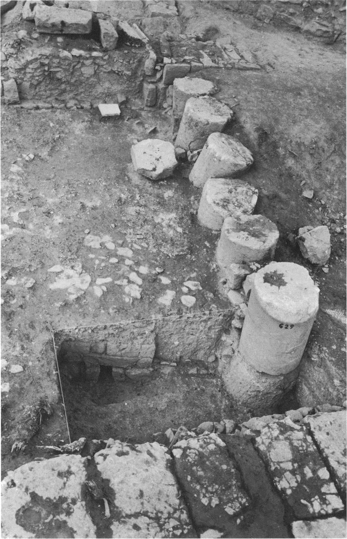 Figure 61
Drums of the columns of Palladius Street, terracing the northwest sidewalk of the street, looking northwest
Tsafrir and Foester (1997) - Fig. 4.4 - Map of central Baysān
from Blanke and Walmsley (2022)
Figure 4.4
Map of central Baysān (from R. Bar-Nathan and W. Atrash, Baysān, 5, plan 1.3).
Blanke and Walmsley (2022)
- Fig. 4.4 - Map of central Baysān
from Blanke and Walmsley (2022)
Figure 4.4
Map of central Baysān (from R. Bar-Nathan and W. Atrash, Baysān, 5, plan 1.3).
Blanke and Walmsley (2022)

 Plate I (left)
Partially restored facade of shops in Bet Shean, showing in the lower half the collapsed upper courses of the walls and arcades of the portico.
Plate II (right)
Gold dinar excavated at Bet She'an, with the marginal legend: 'in the name of Allah, this dinar was minted in the year one hundred thirty one'.
Tsafrir and Foerster (1992b)
- Fig. 10 - Seismic devastation at Baysan
from Walmsley (2001)
Figure 10
‘The deafening roar of devastation’: fallen columns at the crossroads of Baysan; note the impact of the column on the street paving (Walmsley).
Walmsley (2007)
Tsafrir and Foerster (1992b) reported on artifacts found beneath a destruction layer of earthquake induced rubble from what was once an arcaded commercial street in the Byzantine/Early Arab period in Bet She 'an. Among the many artifacts found were pottery, glass and metal vessels, balances, jewelry, and coins. The artifacts dated to the mid 8th century CE. None of the coins dated to later than the first half of the 8th century CE. Of particular significance was a coin hoard discovered in one of the shops. The hoard included 31 gold dinars. The earliest coin from this hoard dated to A.H. 78 (30 March 697 — 19 March 698 CE) and the latest (see Plate II above) was minted in A.H. 131 (31 August 748 - 19 August 749 CE). This coin provides a terminus post quem for the earthquake and, due to its near mint condition, likely a terminus ante quem as well.
Tsafrir and Foester (1997:136) discussed the 749 CE earthquake at Bet She'an
On January 18, 749 C.E., Bet Shean was completely destroyed by an enormous earthquake, well documented in literary sources and archaeological finds. Remains of the collapse were found everywhere in the excavation. In many places the survivors, or perhaps squatters, returned to the ruined houses and settled on top of the debris. No serious effort was made to restore the old buildings, let alone the streets and monuments. From the archaeological point of view, it is fairly easy to distinguish between the layers beneath the earthquake debris and the new buildings above it. Incidentally, the destructive earthquake occurred in the last year of the rule of the Umayyad dynasty, providing a convenient distinction between the medieval, Abbasid, and Fatimid strata above the earthquake debris and the Byzantine and early Islamic strata beneath it. Moreover, the Abbasid buildings after 749 C.E. were built in the style that had been widely used in the earlier Umayyad period; it is likely that many of these settlers were the people who had lived on the site before the earthquake. It is therefore legitimate to consider the rustic post-earthquake structures as representative of the character of Bet Shean before the earthquake.Walmsley (2001:57) dates construction of the market (on Silvanus Street where the coin hoard was found ?) to the time of Hisham (AD 724-743). Walmsley (2007) characterized Bet She'an as being
utterly flattenedby the earthquake
with the still-standing monumental architecture of the Roman and late antique city obliterated by the ferocity of the tremor (fig. 10)
| Effect | Location | Image(s) | Description |
|---|---|---|---|
|
Temple 58066 in Stratum R-2 of Area R
Fig. 3.17 Schematic plan of Stratum R-2 Click on Image to open in a new tab Mazar and Mullins (2007)
Fig. 3.18Reduced plan of Stratum R-2 Click on Image to open in a new tab Mazar and Mullins (2007)
Fig. 3.18Isometric view of Temple 58066 Click on Image to open in a new tab Mazar and Mullins (2007)
Figure 3.29Location of stratigraphic sections: central and western part of Area R Click on image to open in a new tab Mazar and Mullins (2007)
Fig. 3.3Plan of the oval crater showing location of probes Click on Image to open in a new tab Mazar and Mullins (2007) |
Photo 3.59
Photo 3.59 General view of Stratum R-2 Temple 58066.Looking north (1990) Click on image to open in a new tab Mazar and Mullins (2007) Photo 3.61
Photo 3.61Squares N/56. The southeastern corner of Temple 58066. Looking north (1990) Click on image to open in a new tab Mazar and Mullins (2007) Photo 3.62
Photo 3.62Temple 58066, eastern part. Notice Stratum R-1b Wall 58137 overlying Stratum R-2 Wall 58027. Looking south (1990) Looking north (1990) Click on image to open in a new tab Mazar and Mullins (2007) Photo 3.68
Photo 3.68Temple 58066 during excavation, before removal of balks. Foreground: detail of the entrance area to Inner Hall 58120. Stratum R-2’ Pit 58146 is above Bench 58048. Notice the angle of Bench 58048, probably a result of seismic activity. Looking south (1989) Click on image to open in a new tab Mazar and Mullins (2007) Section 7a  Figure 3.37
Section 7a (Sq. L/9-10, looking west) Click on image to open in a new tab Mazar and Mullins (2007) Section 10  Figure 3.42
Section 10 (Sq. L/9, looking south) Click on image to open in a new tab Mazar and Mullins (2007) Section 11  Figure 3.43
Section 11 (Sq. M/9-10, looking east) Click on image to open in a new tab Mazar and Mullins (2007) Section 14
Figure 3.46Section 14 (Sq. M/5-6, looking west) Click on image to open in a new tab Mazar and Mullins (2007) |
|
| Effect | Location | Image(s) | Description |
|---|---|---|---|
|
Loci 18714, Square B/7 and 10743, Square Y/7 in Area S
Photo 1.2 Aerial view of the tell’s summit, looking south.
Panitz-Cohen and Mazar (2009)
Fig. 1.1Topographic plan of Tel Beth-Shean with location of excavation areas Panitz-Cohen and Mazar (2009)
Fig. 4.3bPlan of Stratum S-4, southern part Panitz-Cohen and Mazar (2009)
Photo 4.1General view of Area S, looking south.
(1994) Panitz-Cohen and Mazar (2009:95) |
Photo 4.51
Photo 4.51 Square B/7, S-4 Locus 18714. Remains of human skeleton in situ Panitz-Cohen and Mazar (2009:95) Photo 4.52
Photo 4.52Square Y/7, S-4 Locus 10743, looking southwest. Remains of human skeleton in situ Panitz-Cohen and Mazar (2009:95) |
|
| Effect | Location | Image(s) | Description |
|---|---|---|---|
|
Building SH in Stratum-3a
Photo 1.2 Aerial view of the tell’s summit, looking south.
Panitz-Cohen and Mazar (2009)
Fig. 1.1Topographic plan of Tel Beth-Shean with location of excavation areas Panitz-Cohen and Mazar (2009)
Fig. 4.6aPlan of Stratum S-3a, northern part click on image to open in a new tab Panitz-Cohen and Mazar (2009) |
Photo 4.34 S-3 Building SH above S-4 Building SC, looking west. Note sloping stone foundation of Wall 98845 above large S-4 stones Panitz-Cohen and Mazar (2009) |
|
|
Building SL in Stratum-3a
Photo 1.2 Aerial view of the tell’s summit, looking south.
Panitz-Cohen and Mazar (2009)
Fig. 1.1Topographic plan of Tel Beth-Shean with location of excavation areas Panitz-Cohen and Mazar (2009)
Fig. 4.6bPlan of Stratum S-3a, southern part click on image to open in a new tab Panitz-Cohen and Mazar (2009) |
Photo 4.71
Photo 4.71 S-3 Building SL, looking south. Left: northsouth street. Upper right: UME trench. Lower right: Area R (1994) Click on image to open in a new tab Panitz-Cohen and Mazar (2009) Photo 4.72
Photo 4.72S-3 Building SL, southern end, looking south. S-2 Walls 78814 and 78817 built into center of building. Accumulated layers in north–south street visible in the section to the left of Wall 78702 Click on image to open in a new tab Panitz-Cohen and Mazar (2009) |
|
|
Building SM in Stratum-3a
Photo 1.2 Aerial view of the tell’s summit, looking south.
Panitz-Cohen and Mazar (2009)
Fig. 1.1Topographic plan of Tel Beth-Shean with location of excavation areas Panitz-Cohen and Mazar (2009)
Fig. 4.6bPlan of Stratum S-3a, southern part click on image to open in a new tab Panitz-Cohen and Mazar (2009) |
Photo 4.74
Photo 4.74 General view of southern part of Area S, looking west. Right center: Building SM. Left center: Building SN. Foreground: S-1a building. Background: modern town of Beth-Shean Click on image to open in a new tab Panitz-Cohen and Mazar (2009) Photo 4.75
Photo 4.75S-3 Buildings SM (left) and SN (right), looking southeast. Woman standing on destruction debris 78737 in Space 88700, Building SM. Background: S-1a building (1990) Click on image to open in a new tab Panitz-Cohen and Mazar (2009) Photo 4.76
Photo 4.76S-3 Building SM, looking southeast. Wall 78739 and grindstones on Floor 88700 (1990) Click on image to open in a new tab Panitz-Cohen and Mazar (2009) Photo 4.77
Photo 4.77S-3 Building SM, southwestern corner of Space 88700. Right: Yadin and Geva’s Bin 2555 (1990) Click on image to open in a new tab Panitz-Cohen and Mazar (2009) Photo 4.78
Photo 4.78S-3 Building SM, southeastern part, looking south. Left: stone foundations of S-1a building cutting into S-3 remains (1991) Click on image to open in a new tab Panitz-Cohen and Mazar (2009) Photo 4.79
Photo 4.79S-3 Building SM, looking south. Stone pavement in western part of Space 88700 (1992) Click on image to open in a new tab Panitz-Cohen and Mazar (2009) |
|
| Effect | Location | Image(s) | Description |
|---|---|---|---|
| collapse of the roof of the odeum | odeum (8)
Map of the central area of Scythopolis—Bet Shean (excavations of the Hebrew University and the Israel Antiquities Authority
Tsafrir and Foester (1997) |
|
|
| partial destruction of the theater | theater (1)
Map of the central area of Scythopolis—Bet Shean (excavations of the Hebrew University and the Israel Antiquities Authority
Tsafrir and Foester (1997) |
 Figure 16
The Roman theater, looking east (after Mazor and Bar-Nathan, Qadmoniot 107—8 [1994], 122) Tsafrir and Foester (1997) |
|
nymphaeum severely damaged and rebuilt from the foundations |
nymphaeum (15)
Map of the central area of Scythopolis—Bet Shean (excavations of the Hebrew University and the Israel Antiquities Authority
Tsafrir and Foester (1997) |
Figure 22 The left part of the inscription engraved on a second-century decorated architrave mentioning the governor Artemidorus and the construction of the nymphaeum Tsafrir and Foester (1997) |
|
| Damaged Statues ? | found in the hypocaust of the eastern bathhouse (25) but this would not have been where they originally stood
Map of the central area of Scythopolis—Bet Shean (excavations of the Hebrew University and the Israel Antiquities Authority
Tsafrir and Foester (1997) |
 Figure 37
Headless statue of Aphrodite as found in the hypocaust of the eastern bathhouse Tsafrir and Foester (1997) |
|
| Effect | Location | Image(s) | Description |
|---|---|---|---|
| destruction of Silvanus Hall | Silvanus Hall (26)
Map of the central area of Scythopolis—Bet Shean (excavations of the Hebrew University and the Israel Antiquities Authority
Tsafrir and Foester (1997) |
|
|
| collapse of the porticoes of the Byzantine agora ? | Byzantine agora (20)
Map of the central area of Scythopolis—Bet Shean (excavations of the Hebrew University and the Israel Antiquities Authority
Tsafrir and Foester (1997) |
|
|
| collapse of the portico of the sigma ? | sigma (7)
Map of the central area of Scythopolis—Bet Shean (excavations of the Hebrew University and the Israel Antiquities Authority
Tsafrir and Foester (1997) |
|
|
| collapse of the columns of Palladius Street ? | Palladius Street (6)
Map of the central area of Scythopolis—Bet Shean (excavations of the Hebrew University and the Israel Antiquities Authority
Tsafrir and Foester (1997) |
Figure 60 Drums of the columns of Palladius Street, terracing the area of the street and its northwest sidewalk, looking northwest Tsafrir and Foester (1997)
Figure 61Drums of the columns of Palladius Street, terracing the northwest sidewalk of the street, looking northwest Tsafrir and Foester (1997) |
|
| Effect | Location | Image(s) | Description |
|---|---|---|---|
| Storefront Collapse on Sylvanus Street |
Southeast end of Sylvanus Street
Segment of the remains near the southeast end of Silvanus Street, showing the collapsed shops and arcade after the earthquake of 749 C.E. (after Foerster and Tsafrir, ESI 11 [1992], fig. 45)
Tsafrir and Foester (1997) |
Collapsed Storefronts on Sylvanus Street (Bet She'an) Click on Image to open a 3D View of this in a new tab Screenshot from 3D Lidar Scan by Jefferson Williams - 2 May 2023
Figure 57Silvanus Street, the partially reconstructed facade of the Umayyad shops, and the arcade of the portico as collapsed in the earthquake of 749 C.E., looking northwest Tsafrir and Foester (1997) |
|
| Fallen Column | Sylvanus street near
nymphaeum (15)
Map of the central area of Scythopolis—Bet Shean (excavations of the Hebrew University and the Israel Antiquities Authority
Tsafrir and Foester (1997) |
 Fallen Column on Sylvanus Street near the Nymphaeum (Bet She'an)
Photo by Jefferson Williams - 2 May 2023
Figure 15Palladius Street (center) and the stairway of the Roman temple, with the two monolithic columns as collapsed in the earthquake of 749 C.E. (bottom left), looking southwest Tsafrir and Foester (1997) |
|
| Fallen superstructure of nymphaeum |
nymphaeum (15)
Map of the central area of Scythopolis—Bet Shean (excavations of the Hebrew University and the Israel Antiquities Authority
Tsafrir and Foester (1997) |
Figure 13 Architectural members of the superstructure of the nymphaeum as they fell in the earthquake of 749 C.E., looking south Tsafrir and Foester (1997)  Fallen Architectural Elements on Sylvanus Street near the Nymphaneum (Bet She'an)
Photo by Jefferson Williams - 2 May 2023 |
|
| Collapses at the nymphaeum |
nymphaeum (15)
Map of the central area of Scythopolis—Bet Shean (excavations of the Hebrew University and the Israel Antiquities Authority
Tsafrir and Foester (1997) |
Figure 11 The nymphaeum after the removal of the collapsed architectural members of the facade, looking southwest Tsafrir and Foester (1997)  Fallen Architectural Elements on Sylvanus Street near the Nymphaeum (Bet She'an)
Click on Image to open a 3D View of this in a new tab Screenshot from 3D Lidar Scan by Jefferson Williams - 2 May 2023
Figure 12Rubble from the earthquake of 749 C.E. in front of the nymphaeum, looking west Tsafrir and Foester (1997) |
|
| Sunken pavement ? | near the southeast end of Sylvanus Street (28)
Map of the central area of Scythopolis—Bet Shean (excavations of the Hebrew University and the Israel Antiquities Authority
Tsafrir and Foester (1997) |
Figure 56 Succession of layers near the southeast end of Silvanus Street, looking southeast. The lower courses of the facade of the Umayyad shops can be seen cutting the mosaic pavement of the earlier Silvanus Hall. The mosaic was laid on top of the rather loose soil and ashes with which the Roman pool had been filled, and which later sunk along with the mosaic. The steps on the edge of the pool are seen on the far end of the pool (top); their shape can also be discerned on the northeast (left) through the margins of the mosaic that remained on their original level. Tsafrir and Foester (1997) |
|
| Fallen and columns - inward collapse | Valley Street (17)
Map of the central area of Scythopolis—Bet Shean (excavations of the Hebrew University and the Israel Antiquities Authority
Tsafrir and Foester (1997) |
Figure 48 Columns collapsed on Valley Street in the earthquake of 749 C.E., looking southwest. Note the Umayyad walls that narrowed the street before the earthquake and the Abbasid building on top of the collapse (top right). Tsafrir and Foester (1997)
Figure 6The main junction of Valley Street (center), Southern Street (later Silvanus Street) (right), and the street leading to the temple (left) in front of the Central Monument (bottom), looking northeast Tsafrir and Foester (1997) |
|
- Modified by JW from Fig.3.18 from Mazar and Mullins (2007)
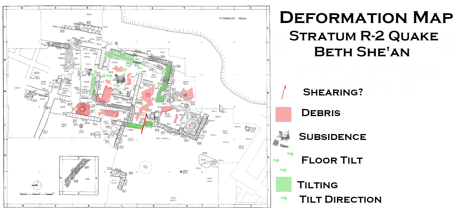 Deformation Map
Modified by JW from Fig. 3.18 from Mazar and Mullins (2007)
Click on image to open in a new tab
- Modified by JW from Fig. 4.3b from Mazar in Panitz-Cohen and Mazar (2009)
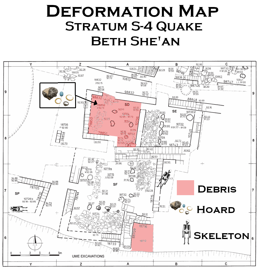 Deformation Map
Modified by JW from Fig. 4.3b from Mazar in Panitz-Cohen and Mazar (2009)
Click on image to open in a new tab
- Modified by JW from Figs. 4.6a and 4.6b from Mazar in Panitz-Cohen and Mazar (2009)
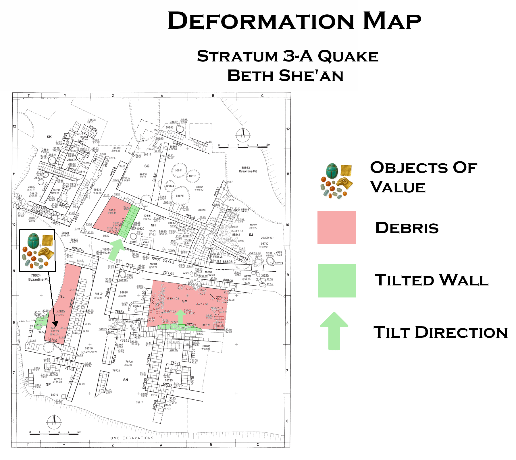 Deformation Map
Modified by JW from Figs. 4.6a and 4.6b from Mazar in Panitz-Cohen and Mazar (2009)
Click on image to open in a new tab
- Modified by JW from Fig. D from Tsafrir and Foester (1997)
 Deformation Map
Modified by JW from Fig. D from Tsafrir and Foester (1997)
- Modified by JW from Fig. D from Tsafrir and Foester (1997)
 Deformation Map
Modified by JW from Fig. D from Tsafrir and Foester (1997)
- Drawn by JW on top of an orthophoto from GovMapIL
 Deformation Map
Drawn by JW on top of an orthophoto from GovMapIL
-
Earthquake Archeological Effects chart
of Rodríguez-Pascua et al (2013: 221-224)
 Earthquake Archeological Effects (EAE)
Rodríguez-Pascua et al (2013: 221-224)
| Effect | Location | Image(s) | Description | Intensity |
|---|---|---|---|---|
|
Baishan (aka Bet She'an) |
|
|
-
Earthquake Archeological Effects chart
of Rodríguez-Pascua et al (2013: 221-224)
Earthquake Archeological Effects (EAE)
Rodríguez-Pascua et al (2013: 221-224)
| Effect | Location | Image(s) | Description | Intensity |
|---|---|---|---|---|
|
Temple 58066 in Stratum R-2 of Area R
Fig. 3.17 Schematic plan of Stratum R-2 Click on Image to open in a new tab Mazar and Mullins (2007)
Fig. 3.18Reduced plan of Stratum R-2 Click on Image to open in a new tab Mazar and Mullins (2007)
Fig. 3.18Isometric view of Temple 58066 Click on Image to open in a new tab Mazar and Mullins (2007)
Figure 3.29Location of stratigraphic sections: central and western part of Area R Click on image to open in a new tab Mazar and Mullins (2007)
Fig. 3.3Plan of the oval crater showing location of probes Click on Image to open in a new tab Mazar and Mullins (2007) |
Photo 3.59
Photo 3.59 General view of Stratum R-2 Temple 58066.Looking north (1990) Click on image to open in a new tab Mazar and Mullins (2007) Photo 3.61
Photo 3.61Squares N/56. The southeastern corner of Temple 58066. Looking north (1990) Click on image to open in a new tab Mazar and Mullins (2007) Photo 3.62
Photo 3.62Temple 58066, eastern part. Notice Stratum R-1b Wall 58137 overlying Stratum R-2 Wall 58027. Looking south (1990) Looking north (1990) Click on image to open in a new tab Mazar and Mullins (2007) Photo 3.68
Photo 3.68Temple 58066 during excavation, before removal of balks. Foreground: detail of the entrance area to Inner Hall 58120. Stratum R-2’ Pit 58146 is above Bench 58048. Notice the angle of Bench 58048, probably a result of seismic activity. Looking south (1989) Click on image to open in a new tab Mazar and Mullins (2007) Section 7a
Figure 3.37Section 7a (Sq. L/9-10, looking west) Click on image to open in a new tab Mazar and Mullins (2007) Section 10
Figure 3.42Section 10 (Sq. L/9, looking south) Click on image to open in a new tab Mazar and Mullins (2007) Section 11
Figure 3.43Section 11 (Sq. M/9-10, looking east) Click on image to open in a new tab Mazar and Mullins (2007) Section 14
Figure 3.46Section 14 (Sq. M/5-6, looking west) Click on image to open in a new tab Mazar and Mullins (2007) |
|
|
-
Earthquake Archeological Effects chart
of Rodríguez-Pascua et al (2013: 221-224)
Earthquake Archeological Effects (EAE)
Rodríguez-Pascua et al (2013: 221-224)
| Effect | Location | Image(s) | Description | Intensity |
|---|---|---|---|---|
|
Loci 18714, Square B/7 and 10743, Square Y/7 in Area S
Photo 1.2 Aerial view of the tell’s summit, looking south.
Panitz-Cohen and Mazar (2009)
Fig. 1.1Topographic plan of Tel Beth-Shean with location of excavation areas Panitz-Cohen and Mazar (2009)
Fig. 4.3bPlan of Stratum S-4, southern part Panitz-Cohen and Mazar (2009)
Photo 4.1General view of Area S, looking south.
(1994) Panitz-Cohen and Mazar (2009:95) |
Photo 4.51
Photo 4.51 Square B/7, S-4 Locus 18714. Remains of human skeleton in situ Panitz-Cohen and Mazar (2009:95) Photo 4.52
Photo 4.52Square Y/7, S-4 Locus 10743, looking southwest. Remains of human skeleton in situ Panitz-Cohen and Mazar (2009:95) |
|
|
-
Earthquake Archeological Effects chart
of Rodríguez-Pascua et al (2013: 221-224)
Earthquake Archeological Effects (EAE)
Rodríguez-Pascua et al (2013: 221-224)
| Effect | Location | Image(s) | Description | Intensity |
|---|---|---|---|---|
|
Building SH in Stratum-3a
Photo 1.2 Aerial view of the tell’s summit, looking south.
Panitz-Cohen and Mazar (2009)
Fig. 1.1Topographic plan of Tel Beth-Shean with location of excavation areas Panitz-Cohen and Mazar (2009)
Fig. 4.6aPlan of Stratum S-3a, northern part click on image to open in a new tab Panitz-Cohen and Mazar (2009) |
Photo 4.34 S-3 Building SH above S-4 Building SC, looking west. Note sloping stone foundation of Wall 98845 above large S-4 stones Panitz-Cohen and Mazar (2009) |
|
|
|
Building SL in Stratum-3a
Photo 1.2 Aerial view of the tell’s summit, looking south.
Panitz-Cohen and Mazar (2009)
Fig. 1.1Topographic plan of Tel Beth-Shean with location of excavation areas Panitz-Cohen and Mazar (2009)
Fig. 4.6bPlan of Stratum S-3a, southern part click on image to open in a new tab Panitz-Cohen and Mazar (2009) |
Photo 4.71
Photo 4.71 S-3 Building SL, looking south. Left: northsouth street. Upper right: UME trench. Lower right: Area R (1994) Click on image to open in a new tab Panitz-Cohen and Mazar (2009) Photo 4.72
Photo 4.72S-3 Building SL, southern end, looking south. S-2 Walls 78814 and 78817 built into center of building. Accumulated layers in north–south street visible in the section to the left of Wall 78702 Click on image to open in a new tab Panitz-Cohen and Mazar (2009) |
|
|
|
Building SM in Stratum-3a
Photo 1.2 Aerial view of the tell’s summit, looking south.
Panitz-Cohen and Mazar (2009)
Fig. 1.1Topographic plan of Tel Beth-Shean with location of excavation areas Panitz-Cohen and Mazar (2009)
Fig. 4.6bPlan of Stratum S-3a, southern part click on image to open in a new tab Panitz-Cohen and Mazar (2009) |
Photo 4.74
Photo 4.74 General view of southern part of Area S, looking west. Right center: Building SM. Left center: Building SN. Foreground: S-1a building. Background: modern town of Beth-Shean Click on image to open in a new tab Panitz-Cohen and Mazar (2009) Photo 4.75
Photo 4.75S-3 Buildings SM (left) and SN (right), looking southeast. Woman standing on destruction debris 78737 in Space 88700, Building SM. Background: S-1a building (1990) Click on image to open in a new tab Panitz-Cohen and Mazar (2009) Photo 4.76
Photo 4.76S-3 Building SM, looking southeast. Wall 78739 and grindstones on Floor 88700 (1990) Click on image to open in a new tab Panitz-Cohen and Mazar (2009) Photo 4.77
Photo 4.77S-3 Building SM, southwestern corner of Space 88700. Right: Yadin and Geva’s Bin 2555 (1990) Click on image to open in a new tab Panitz-Cohen and Mazar (2009) Photo 4.78
Photo 4.78S-3 Building SM, southeastern part, looking south. Left: stone foundations of S-1a building cutting into S-3 remains (1991) Click on image to open in a new tab Panitz-Cohen and Mazar (2009) Photo 4.79
Photo 4.79S-3 Building SM, looking south. Stone pavement in western part of Space 88700 (1992) Click on image to open in a new tab Panitz-Cohen and Mazar (2009) |
|
|
-
Earthquake Archeological Effects chart
of Rodríguez-Pascua et al (2013: 221-224)
Earthquake Archeological Effects (EAE)
Rodríguez-Pascua et al (2013: 221-224)
| Effect | Location | Image(s) | Description | Intensity |
|---|---|---|---|---|
| collapse of the roof of the odeum - Displaced Walls | odeum (8)
Map of the central area of Scythopolis—Bet Shean (excavations of the Hebrew University and the Israel Antiquities Authority
Tsafrir and Foester (1997) |
|
VII+ | |
| partial destruction of the theater - Displaced Walls ? | theater (1)
Map of the central area of Scythopolis—Bet Shean (excavations of the Hebrew University and the Israel Antiquities Authority
Tsafrir and Foester (1997) |
Figure 16 The Roman theater, looking east (after Mazor and Bar-Nathan, Qadmoniot 107—8 [1994], 122) Tsafrir and Foester (1997) |
|
VII+ |
nymphaeum severely damaged and rebuilt from the foundations- Collapsed Walls |
nymphaeum (15)
Map of the central area of Scythopolis—Bet Shean (excavations of the Hebrew University and the Israel Antiquities Authority
Tsafrir and Foester (1997) |
Figure 22 The left part of the inscription engraved on a second-century decorated architrave mentioning the governor Artemidorus and the construction of the nymphaeum Tsafrir and Foester (1997) |
|
VIII+ |
-
Earthquake Archeological Effects chart
of Rodríguez-Pascua et al (2013: 221-224)
Earthquake Archeological Effects (EAE)
Rodríguez-Pascua et al (2013: 221-224)
| Effect | Location | Image(s) | Description | Intensity |
|---|---|---|---|---|
| destruction of Silvanus Hall - collapsed walls and fallen columns | Silvanus Hall (aka (26)
Map of the central area of Scythopolis—Bet Shean (excavations of the Hebrew University and the Israel Antiquities Authority
Tsafrir and Foester (1997) |
|
VIII+ | |
| collapse of the porticoes of the Byzantine agora ? - Arch Collapse | Byzantine agora (20)
Map of the central area of Scythopolis—Bet Shean (excavations of the Hebrew University and the Israel Antiquities Authority
Tsafrir and Foester (1997) |
|
VI+ | |
| collapse of the portico of the sigma ? - Arch collapse | sigma (7)
Map of the central area of Scythopolis—Bet Shean (excavations of the Hebrew University and the Israel Antiquities Authority
Tsafrir and Foester (1997) |
|
VI+ | |
| collapse of the columns of Palladius Street ? - Fallen columns | Palladius Street (6)
Map of the central area of Scythopolis—Bet Shean (excavations of the Hebrew University and the Israel Antiquities Authority
Tsafrir and Foester (1997) |
Figure 60 Drums of the columns of Palladius Street, terracing the area of the street and its northwest sidewalk, looking northwest Tsafrir and Foester (1997)
Figure 61Drums of the columns of Palladius Street, terracing the northwest sidewalk of the street, looking northwest Tsafrir and Foester (1997) |
|
V+ |
-
Earthquake Archeological Effects chart
of Rodríguez-Pascua et al (2013: 221-224)
Earthquake Archeological Effects (EAE)
Rodríguez-Pascua et al (2013: 221-224)
| Effect | Location | Image(s) | Description | Intensity |
|---|---|---|---|---|
| Storefront Collapse on Sylvanus Street - Collapsed Walls |
Southeast end of Sylvanus Street
Segment of the remains near the southeast end of Silvanus Street, showing the collapsed shops and arcade after the earthquake of 749 C.E. (after Foerster and Tsafrir, ESI 11 [1992], fig. 45)
Tsafrir and Foester (1997) |
Collapsed Storefronts on Sylvanus Street (Bet She'an) Click on Image to open a 3D View of this in a new tab Screenshot from 3D Lidar Scan by Jefferson Williams - 2 May 2023
Figure 57Silvanus Street, the partially reconstructed facade of the Umayyad shops, and the arcade of the portico as collapsed in the earthquake of 749 C.E., looking northwest Tsafrir and Foester (1997) |
|
VIII+ |
| Fallen Column | Sylvanus street near
nymphaeum (15)
Map of the central area of Scythopolis—Bet Shean (excavations of the Hebrew University and the Israel Antiquities Authority
Tsafrir and Foester (1997) |
Fallen Column on Sylvanus Street near the Nymphaeum (Bet She'an)
Photo by Jefferson Williams - 2 May 2023
Figure 15Palladius Street (center) and the stairway of the Roman temple, with the two monolithic columns as collapsed in the earthquake of 749 C.E. (bottom left), looking southwest Tsafrir and Foester (1997) |
|
V+ |
| Fallen superstructure of nymphaeum indicating collapsed walls |
nymphaeum (15)
Map of the central area of Scythopolis—Bet Shean (excavations of the Hebrew University and the Israel Antiquities Authority
Tsafrir and Foester (1997) |
Figure 13 Architectural members of the superstructure of the nymphaeum as they fell in the earthquake of 749 C.E., looking south Tsafrir and Foester (1997)
Fallen Architectural Elements on Sylvanus Street near the Nymphaneum (Bet She'an)
Photo by Jefferson Williams - 2 May 2023 |
|
VIII+ |
| Collapses at the nymphaeum - upper parts of walls collapsed |
nymphaeum (15)
Map of the central area of Scythopolis—Bet Shean (excavations of the Hebrew University and the Israel Antiquities Authority
Tsafrir and Foester (1997) |
Figure 11 The nymphaeum after the removal of the collapsed architectural members of the facade, looking southwest Tsafrir and Foester (1997)
Fallen Architectural Elements on Sylvanus Street near the Nymphaeum (Bet She'an)Click on Image to open a 3D View of this in a new tab Screenshot from 3D Lidar Scan by Jefferson Williams - 2 May 2023
Figure 12Rubble from the earthquake of 749 C.E. in front of the nymphaeum, looking west Tsafrir and Foester (1997) |
|
VIII+ |
| Sunken pavement ? - Anthropogenic compacted stratum | near the southeast end of Sylvanus Street (28)
Map of the central area of Scythopolis—Bet Shean (excavations of the Hebrew University and the Israel Antiquities Authority
Tsafrir and Foester (1997) |
Figure 56 Succession of layers near the southeast end of Silvanus Street, looking southeast. The lower courses of the facade of the Umayyad shops can be seen cutting the mosaic pavement of the earlier Silvanus Hall. The mosaic was laid on top of the rather loose soil and ashes with which the Roman pool had been filled, and which later sunk along with the mosaic. The steps on the edge of the pool are seen on the far end of the pool (top); their shape can also be discerned on the northeast (left) through the margins of the mosaic that remained on their original level. Tsafrir and Foester (1997) |
VI-VII+ | |
| Fallen and columns - inward collapse | Valley Street (17)
Map of the central area of Scythopolis—Bet Shean (excavations of the Hebrew University and the Israel Antiquities Authority
Tsafrir and Foester (1997) |
Figure 48 Columns collapsed on Valley Street in the earthquake of 749 C.E., looking southwest. Note the Umayyad walls that narrowed the street before the earthquake and the Abbasid building on top of the collapse (top right). Tsafrir and Foester (1997)
Figure 6The main junction of Valley Street (center), Southern Street (later Silvanus Street) (right), and the street leading to the temple (left) in front of the Central Monument (bottom), looking northeast Tsafrir and Foester (1997) |
|
V+ |
| Description | Location | Image | Causitive Earthquake | Notes |
|---|---|---|---|---|
| Fallen Column | Sylvanus Street Near Nymphaneum |
Fallen Column on Sylvanus Street near the Nymphaneum (Bet She'an)
Photo by Jefferson Williams - 2 May 2023 |
Holy Desert Quake of the Sabbatical Year Sequence - January 749 CE | |
| Fallen Architectural Elements | Sylvanus Street Near Nymphaneum |
Fallen Architectural Elements on Sylvanus Street near the Nymphaneum (Bet She'an)
Photo by Jefferson Williams - 2 May 2023 |
Holy Desert Quake of the Sabbatical Year Sequence - January 749 CE | |
| Collapses in Front of Nymphaneum | Sylvanus Street Near Nymphaneum |
Fallen Architectural Elements on Sylvanus Street near the Nymphaneum (Bet She'an)
Screenshot from 3D Lidar Scan by Jefferson Williams - 2 May 2023 |
Holy Desert Quake of the Sabbatical Year Sequence - January 749 CE | See 3D Scan |
| Collapsed Storefronts | Sylvanus Street |
Collapsed Storefronts on Sylvanus Street (Bet She'an)
Screenshot from 3D Lidar Scan by Jefferson Williams - 2 May 2023 |
Holy Desert Quake of the Sabbatical Year Sequence - January 749 CE | See 3D Scan |
| Broken Corners | Theater |
 Broken Corners in Arch of the Theater (Bet She'an)
Photo by Jefferson Williams - 2 May 2023 |
Undated | |
| Deformed Arch | Structure just south of the Park Entrance |
 Deformed Arch from a Structure just south of the Park Entrance (Bet She'an)
Photo by Jefferson Williams - 2 May 2023 |
Undated | |
| Deformed Arch Axis Direction - 203° | Structure just south of the Park Entrance |
 Measurement of Deformed Arch Axial Direction from a Structure just south of the Park Entrance (Bet She'an)
Photo by Jefferson Williams - 2 May 2023 |
Undated |