Baalbek
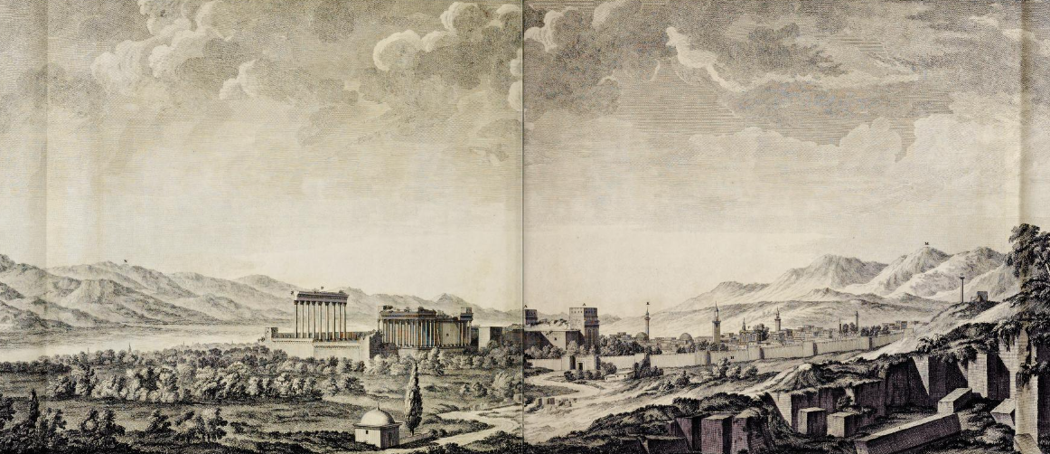 Drawing of Baalbek around 1751 CE
Wood (1757)
| Transliterated Name | Language | Name |
|---|---|---|
| Baalbek | Arabic | بعلبك |
| Baalbek | Syriac-Aramaic | ܒܥܠܒܟ |
| Belbek | Hebrew | בעלבק |
| Heliopolis | Greek | Ἡλιούπολις |
| Heliopoleos | Latin | Heliopoleos |
- Baalbek in Google Earth
 Baalbek
click on image to explore this site on a new tab in Google Earth
 Plate I
Plan of the city of Balbec, (showing only the situation of the ancient buildings which remain
- Portico
- Hexagonal court
- Quadrangular court
- Great temple
- The most entire temple
- The circular temple
- A Doric column
- The city walls
- The city gates
Wood (1757)
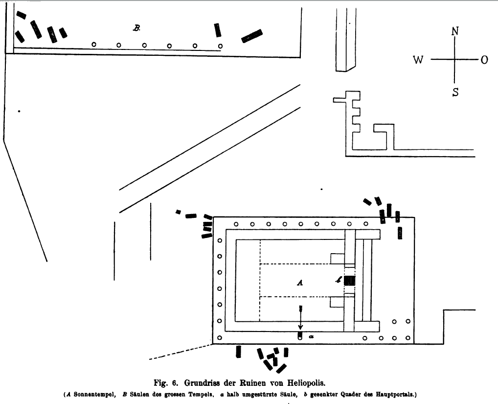 Fig. 6
Plan of the ruins of Heliopolis.
- Sun temple
- pillars of the great temple
- half fallen pillar
- lowered ashlar of the main portal
Dienner (1886)
- Fig. 6.6a - Slipped keystone
over the main doorway of the Temple of Bacchus from Rababeh (2005)
 Fig. 6.6a
Rich decorated flat arch of the main doorway of the Temple of Bacchus
Rababeh (2005) - Fig. 6.6b - Detailed view
of the slipped keystone over the main doorway of the Temple of Bacchus from Rababeh (2005)
 Fig. 6.6b
Detailed view of the flat arch of the main doorway of the Temple of Bacchus
Rababeh (2005) - Photo from 1843 of the
Hexagonal Court in the Temple of Jupiter at Baalbek from Metropolitan Museum of Art the
 Hexagonal Court, Temple of Jupiter, Baalbek (290. Baalbec. 1843. Cour Hexagone.)
Joseph-Philibert Girault de Prangey French 1843
Hexagonal Court, Temple of Jupiter, Baalbek (290. Baalbec. 1843. Cour Hexagone.)
Joseph-Philibert Girault de Prangey French 1843
Click on Image to open a photo and description in a new tab
Metropolitan Museum of Art - Public Domain
- Baalbek from Roberts (1855)
 Baalbec
Roberts (1855) - The slipping keystone of Baalbek
from Roberts (1855)
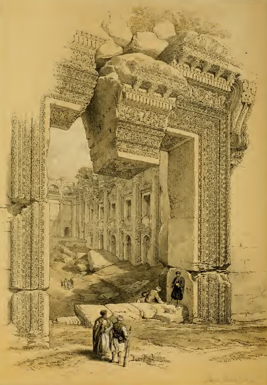 The slipping keystone of the Soffit at the entrance to the Lesser Temple
Roberts (1855) - 'Round' Temple of Baalbek
from Roberts (1855)
 Circular Temple at Baalbek
Roberts (1855)
- Due to reports of continual decay, vandalism, stone-robbing, etc. to the Ruins of Baalbek during this time, it is difficult to identify all of the potential seismic damage.
| Effect | Location | Image(s) | Description |
|---|---|---|---|
| 3 Fallen Columns | Peristyle of the Great Temple (aka the Temple of Jupiter)
Fig. 6Plan of the ruins of Heliopolis.
Dienner (1886) |
 Figure 1
G.B. Borra 1751 'View of both temples, in their present state, from the south' Lewis (1999) 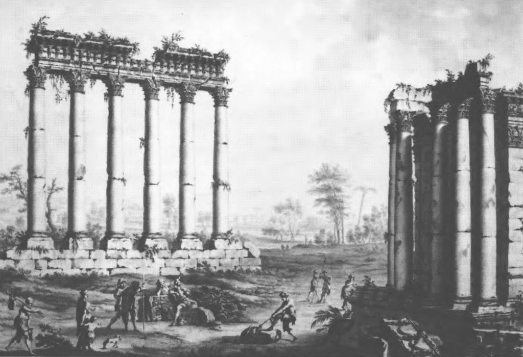 Figure 3
J. Bruce, 1767: Baalbek, the west side of the smaller temple and the six columns of the larger temple Lewis (1999) |
|
| Dropped Keystones in Arches | Keystone of the soffit of the door of the lesser Temple
Fig. 6Plan of the ruins of Heliopolis.
Dienner (1886) |
The slipping keystone of the Soffit at the entrance to the Lesser Temple Roberts (1855) 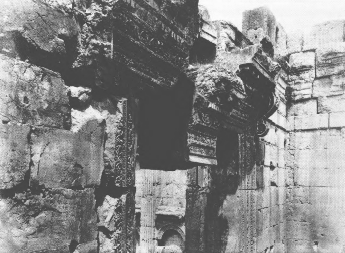 Figure 9
F. Frith, 1857-58 : Baalbek, entrance to the smaller temple Lewis (1999) 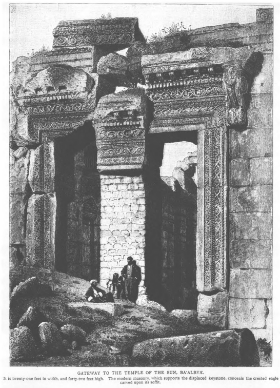 Figure 9
Photograph, c.1880: Baalbek, entrance to the smaller temple, the keystone supported by 'Burton's wall' Lewis (1999)
Fig. 6.6aRich decorated flat arch of the main doorway of the Temple of Bacchus Rababeh (2005)
Fig. 6.6bDetailed view of the flat arch of the main doorway of the Temple of Bacchus Rababeh (2005) |
Lewis (1999:242) noted that the
monumental doorway of the smaller temple remained intact prior to 1759 CE.
Nor can there be any doubt that the monumental doorway of the smaller temple, with its elaborately carved lintel, remained intact in this period. The joints between the three blocks of stone of which the lintel is composed were evidently so perfect in the earlier part of the period that Monconys (1665, 348-9) and la Roque (1723, 136-7) thought that it consisted of a single piece of stone; Pococke (1745, 109) was the first to realise that there were three. None of the travellers says that there was any structural damage to the lintel, although its sculptured decorations had been damaged (Monconys 1665, 349; Nijenburg 1759, 274; Dawkins 1751, quoted below)Volney (1788:240) observed changes after the 25 Nov. 1759 CE Baalbek Quake. The keystone of the soffit of the door of the lesser Temple descended 8 inches. Burton and Drake (1872:37) reproduced a letter from Isabel Burton written in 1870 CE which also stated that the keystone in the soffithad begun to slip about 1759and successively fell lower with every slight earthquake. |
| Collapsed Roof ? | 'Round Temple'
Plate I Plan of the city of Balbec, (showing only the situation of the ancient buildings which remain
Wood (1757) |
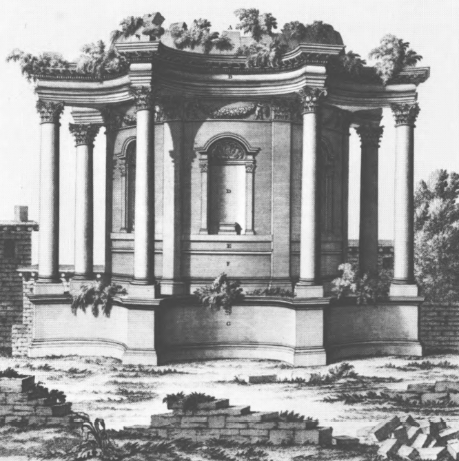 Figure 2
G.B. Borra;, 1751 'The circular temple in its present state' Lewis (1999) 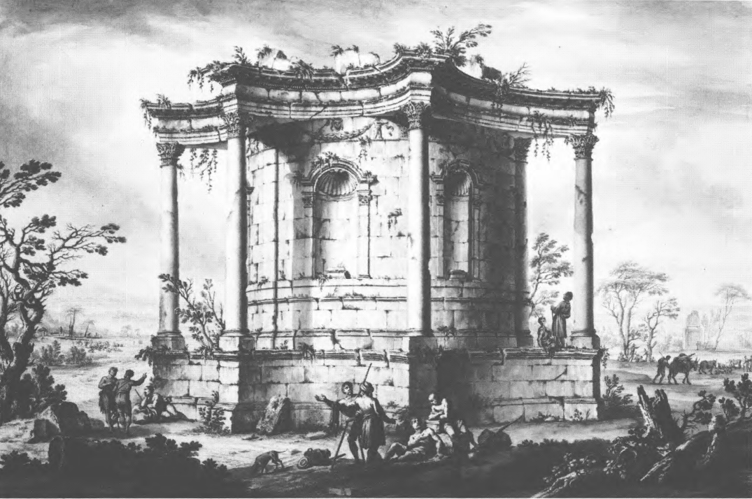 Figure 6
J. Bruce, 1767: Baalbek, the 'round temple' Lewis (1999) 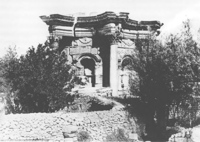 Figure 2
F. Frith, 1857-58: Baalbek, 'the round temple' Lewis (1999) |
|
| Earth fissure |
 Figure 1
Schematic map of main active faults of Lebanese re-straining bend: bold colored lines show maximum rupture lengths of large historical earthquakes in past 1000 yr, deduced from this study and historical documents (see discussion in text). Bold ashed lines enclose areas where intensities ≥VIII were reported in A.D. 1202 (red) and November 1759 (green) according to Ambraseys and Melville (1988) and Ambraseys and Barazangi (1989).Open symbols show location of cities (squares) and sites (circles) cited in text. Black dots mark location of field photographs shown in Figure DR1 (see footnote 1). (Inset: Levant transform plate boundary.) JW: Green fault labeled SF (Serghaya fault) is Daeron et al (2005)'s postulated fault break for the 25 Nov. 1759 CE Baalbek Quake Daeron et al (2005) |
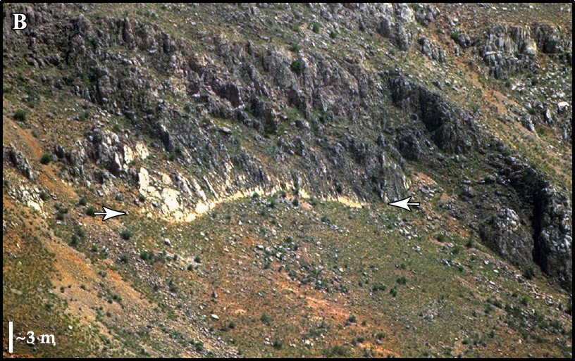 Figure DR1b
fresher seismic scarplet on Serghaya fault JW: possibly due to 25 Nov. 1759 CE Baalbek Quake Daeron et al (2005) Supplemental 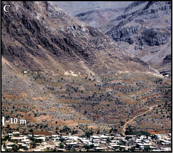 Figure DR1c
fresher seismic scarplet on Serghaya fault JW: possibly due to 25 Nov. 1759 CE Baalbek Quake Daeron et al (2005) Supplemental |
Since October 30, a furious shock at 3:45 in the morning made us fear a fate like the one in Lisbon [JW: the 1755 Lisbon Earthquake]. We feel the continuing tremors day and night. There was another one on November 25, which was stronger and longer than the first. ... Large fissures opened up in the earth on the Baalbek side [JW: likely on 25 Nov. 1759 CE] and it is said that these cracks extend more than 20 leagues (~110 km.)- Anonymous letter, dated 29 December 1759 CE, from the French Consulate in Sidon to the Chamber of Chamber of Commerce of Marseilles (F.Ch.R., 1927:591-594) |
Side by side illustrations show that nine columns of the peristyle of the Great Temple
(aka the Temple of Jupiter) were standing in 1751 CE (left) and only six remained in 1767 CE (right).Figure 1 (left)
G.B. Borra 1751 'View of both temples, in their present state,from the south'
Figure 3 (right)
J. Bruce, 1767: Baalbek, the west side of the smaller temple and the six columns of the larger temple
both Figures from Lewis (1999)
Lewis (1999:242) noted that, prior to 1759 CE, nine columns of the peristyle of the Great Temple (aka the Temple of Jupiter) remained standing.
There is no doubt that nine columns of the peristyle of the great temple remained standing throughout this period [before 1759 CE]; Belon in 1548 (1553, 4), Monconys in 1647 (1665, 348 - 9), la Roque in 1689 (1723, 127), Maundrell in 1697 (1721, 136 -7), Pococke in 1738 ( 1745, II, 110), Nijenburg or Heyman perhaps about 1720, (1759, II, 275), and Wood in 1751 (1757 passim) all mention this.After the earthquake of 25 Nov. 1759 CE, only 6 remained standing as noted by Volney (1788:239-240) who visited the Temple in 1784 CE and noticed that only six columns were still standing. This compares to the nine which had been standing as shown by Wood (1757:Tab. XXIV) based on observations made in 1751 CE.
The progressively slipping keystone at the entrance to the lesser TempleFigure 9 (left)
F. Frith, 1857-58 : Baalbek, entrance to the smaller temple
Figure 10 (right)
Photograph, c.1880: Baalbek, entrance to the smaller temple, the keystone supported by 'Burton's wall'
both Figures from Lewis (1999)
Lewis (1999:242) noted that the monumental doorway of the smaller temple remained intact prior to 1759 CE.
Nor can there be any doubt that the monumental doorway of the smaller temple, with its elaborately carved lintel, remained intact in this period. The joints between the three blocks of stone of which the lintel is composed were evidently so perfect in the earlier part of the period that Monconys (1665, 348-9) and la Roque (1723, 136-7) thought that it consisted of a single piece of stone; Pococke (1745, 109) was the first to realise that there were three. None of the travellers says that there was any structural damage to the lintel, although its sculptured decorations had been damaged (Monconys 1665, 349; Nijenburg 1759, 274; Dawkins 1751, quoted below)Volney (1788:240) observed changes after the 25 Nov. 1759 CE Baalbek Quake. The keystone of the soffit of the door of the lesser Temple
descended 8 inches. Burton and Drake (1872:37) reproduced a letter from Isabel Burton written in 1870 CE which also stated that the
keystone in the soffithad begun
to slip about 1759and successively fell lower
with every slight earthquake.
The 'Round Temple' over timeFigure 2 (left)
G.B. Borra;, 1751 'The circular temple in its present state'
Figure 6 (middle)
J. Bruce, 1767: Baalbek, the 'round temple'
Figure 8 (right)
F. Frith, 1857-58: Baalbek, 'the round temple'
both Figures from Lewis (1999)
Lewis (1999:249-252) thought it probable that the 'Round Temple' was also damaged in the 25 Nov. 1759 CE Baalbek Quake.
Bruce's drawing of the little 'round' temple (Figure 6) gives the impression that, although the roof had fallen in, the exterior was in reasonably sound condition and Borra's two drawings (Figure 2 herein and pI. 43 in Wood) give an almost absurd impression of solidity and good order. This is at odds with Maundrell's description of the temple as being "in a very tottering state" in 1697 (1721, 135). At that time, and as late as 1751, the temple was used as a church by a Greek Orthodox congregation which later - we do not know when - abandoned it. Bruce's drawing shows only one side of the temple, the back or south side, but in 1784 Cassas produced two drawings (his pIs 56 and 57), one of the same side as Bruce's and not unlike his, and the other of the entrance or north side. The latter shows that much of the interior and of the north side had fallen away and was now completely ruined.The circular temple is also known as the round temple or temple of Venus and is located southeast of the Acropolis ( Leila Badee in Meyers et al, 1997)
The collapse must have taken place between 1751, when Wood and Borra were there and the temple was still in use, and 1784, when Cassas was there. We cannot be sure whether it took place before or after Bruce's visit, because he did not draw the northern side, but it must be thought extremely probable that the earthquakes of 1759 were responsible for this as for so much other damage in Baalbek.
- Fig. 6 - Plan of Ruins at Baalbek
from Dienner (1886)
Fig. 6
Plan of the ruins of Heliopolis.
- Sun temple
- pillars of the great temple
- half fallen pillar
- lowered ashlar of the main portal
Dienner (1886)
Dienner (1886:252-258) made some early archaeoseismic observations at Baalbek
The following plan of the western part of the Acropolis of Ba`albek also shows in the floor plan of the two temples the position of the column fragments, the ruins of which come from the colonnades of the former. Although the position of the column shafts cannot be used to determine the direction of the tremor, since the way they fall is too much influenced by the rotation around the iron pivot at the base, a superficial overview of the distribution of their material is possible recognize that the north and south sides of the buildings were more affected by the shock of the shock than the east and west fronts.
As late as 1751, nine columns stood upright from the peristyle of the great temple. On the other hand, in 1784 Volney1 counted only six of them when he visited. The other three fell victim to the terrible earthquake of 1759. But these three fallen columns have all been thrown off to the north side, as if a southerly blow had pulled the base from under the shafts. Likewise, in the peristyle of the Temple of the Sun, nine pillars were destroyed by the earthquake of 1759, specifically on the south side of the temple. In the main portal, which is directed from north to south, the impact tore loose the middle cuboid (I) of the sketch), which bore the symbol of Helios, the winged eagle with the serpent's staff, in raised work, so that it was about a meter deep between the other two ashlars of the central bay and had to be supported by a base of masonry in 1870. A meridionally directed undulation of the ground was probably most likely to have caused the W.—O. bursting the joints between the ashlars of the porticus and thus caused the central stone to be lowered.
The most instructive point of the building for judging the nature of the earthquake is, however, at the southern peristyle of the Temple of the Sun (a of the plan sketch). While between the south-west corner of the peristyle and the colonnade of the vestibule all the columns have been thrown off the substructure of the temple, here one of them is still leaning upright against the wall of the cella. The shaft is broken off near the base, but the iron clamps which held it together withstood the force of the blow, and so the column leans due north towards the main maner, whose facade it partially damaged in its fall. Only a southward tremor could produce such an effect. The base of the stylobate was extended to the south pushed before the ceiling of the peristyle was able to yield. So the shaft of the column had to break in two and fall to the north. Any other direction of the blow would have resulted in its falling into the inner space of the peristyle or over the ramparts of the Acropolis.
Observations of this kind teach us that in the great earthquake of 1759 the seismic movement of at least one shock was north-south.
- Earthquake Archeological Effects chart
of Rodríguez-Pascua et al (2013: 221-224)
 Earthquake Archeological Effects (EAE)
click on image to open a higher resolution version in a new tab
Rodríguez-Pascua et al (2013: 221-224) - Subjective MMI Intensity
Scale

 Subjective MMI Intensity Scale
Click on image to open in a new tab - Environmental Effects (ESI 2007)
 Graphic Representation of ESI 2007 Intensity
click on image to open a higher resolution version in a new tab
- Synoptic Table of ESI 2007
Intensity Degrees from Michetti et al. (2007)
 Plate I
Synoptic Table of ESI 2007 Intensity Degrees - The accuracy of the assessment improves in the higher degrees of the scale, in particular in the range of occurrence of primary effects, typically starting from intensity VIII, and with growing resolution for intensity IX, X, XI and XII. Hence, in the yellow group of intensity degrees (XI-XII) they become the most effective tool for intensity assessment.
click on image to open a higher resolution version in a new tab
Michetti et al. (2007)

| Effect | Location | Image(s) | Description | Intensity |
|---|---|---|---|---|
|
Baalbek |
|
|
- Earthquake Archeological Effects chart
of Rodríguez-Pascua et al (2013: 221-224)
Earthquake Archeological Effects (EAE)
click on image to open a higher resolution version in a new tab
Rodríguez-Pascua et al (2013: 221-224)
| Effect | Location | Image(s) | Description | Intensity |
|---|---|---|---|---|
|
Baalbek |
|
|
- Simple MMI Intensity Scale
 Simple MMI Intensity
Scale
Simple MMI Intensity
Scale
Click on image to open in a new tab - More Subjective MMI Intensity Scale
More Subjective MMI Scale
Click on image to open in a new tab
| Effect | Location | Image(s) | Description(s) | Intensity |
|---|---|---|---|---|
|
Palmyra (aka Tadmur) |
|
|
- Earthquake Archeological Effects chart
of Rodríguez-Pascua et al (2013: 221-224)
Earthquake Archeological Effects (EAE)
click on image to open a higher resolution version in a new tab
Rodríguez-Pascua et al (2013: 221-224) - Subjective MMI Intensity
Scale
Subjective MMI Intensity Scale
Click on image to open in a new tab - Environmental Effects (ESI 2007)
Graphic Representation of ESI 2007 Intensity
click on image to open a higher resolution version in a new tab
- Synoptic Table of ESI 2007
Intensity Degrees from Michetti et al. (2007)
Plate I
Synoptic Table of ESI 2007 Intensity Degrees - The accuracy of the assessment improves in the higher degrees of the scale, in particular in the range of occurrence of primary effects, typically starting from intensity VIII, and with growing resolution for intensity IX, X, XI and XII. Hence, in the yellow group of intensity degrees (XI-XII) they become the most effective tool for intensity assessment.
click on image to open a higher resolution version in a new tab
Michetti et al. (2007)
| Effect | Location | Image(s) | Description | Intensity |
|---|---|---|---|---|
|
Baalbek |
|
|
- Earthquake Archeological Effects chart
of Rodríguez-Pascua et al (2013: 221-224)
Earthquake Archeological Effects (EAE)
click on image to open a higher resolution version in a new tab
Rodríguez-Pascua et al (2013: 221-224)
| Effect | Location | Image(s) | Description | Intensity |
|---|---|---|---|---|
|
Baalbek |
|
|
-
Earthquake Archeological Effects chart
of Rodríguez-Pascua et al (2013: 221-224)
Earthquake Archeological Effects (EAE)
Rodríguez-Pascua et al (2013: 221-224)
| Effect | Location | Image(s) | Description | Intensity |
|---|---|---|---|---|
| 3 Fallen Columns | Peristyle of the Great Temple (aka the Temple of Jupiter)
Fig. 6Plan of the ruins of Heliopolis.
Dienner (1886) |
Figure 1 G.B. Borra 1751 'View of both temples, in their present state, from the south' Lewis (1999)
Figure 3J. Bruce, 1767: Baalbek, the west side of the smaller temple and the six columns of the larger temple Lewis (1999) |
|
V+ |
| Dropped Keystones in Arches | Keystone of the soffit of the door of the lesser Temple
Fig. 6Plan of the ruins of Heliopolis.
Dienner (1886) |
The slipping keystone of the Soffit at the entrance to the Lesser Temple Roberts (1855)
Figure 9F. Frith, 1857-58 : Baalbek, entrance to the smaller temple Lewis (1999)
Figure 9Photograph, c.1880: Baalbek, entrance to the smaller temple, the keystone supported by 'Burton's wall' Lewis (1999)
Fig. 6.6aRich decorated flat arch of the main doorway of the Temple of Bacchus Rababeh (2005)
Fig. 6.6bDetailed view of the flat arch of the main doorway of the Temple of Bacchus Rababeh (2005) |
Lewis (1999:242) noted that the
monumental doorway of the smaller temple remained intact prior to 1759 CE.
Nor can there be any doubt that the monumental doorway of the smaller temple, with its elaborately carved lintel, remained intact in this period. The joints between the three blocks of stone of which the lintel is composed were evidently so perfect in the earlier part of the period that Monconys (1665, 348-9) and la Roque (1723, 136-7) thought that it consisted of a single piece of stone; Pococke (1745, 109) was the first to realise that there were three. None of the travellers says that there was any structural damage to the lintel, although its sculptured decorations had been damaged (Monconys 1665, 349; Nijenburg 1759, 274; Dawkins 1751, quoted below)Volney (1788:240) observed changes after the 25 Nov. 1759 CE Baalbek Quake. The keystone of the soffit of the door of the lesser Temple descended 8 inches. Burton and Drake (1872:37) reproduced a letter from Isabel Burton written in 1870 CE which also stated that the keystone in the soffithad begun to slip about 1759and successively fell lower with every slight earthquake. |
VI+ |
| Earth fissure |
Figure 1 Schematic map of main active faults of Lebanese re-straining bend: bold colored lines show maximum rupture lengths of large historical earthquakes in past 1000 yr, deduced from this study and historical documents (see discussion in text). Bold ashed lines enclose areas where intensities ≥VIII were reported in A.D. 1202 (red) and November 1759 (green) according to Ambraseys and Melville (1988) and Ambraseys and Barazangi (1989).Open symbols show location of cities (squares) and sites (circles) cited in text. Black dots mark location of field photographs shown in Figure DR1 (see footnote 1). (Inset: Levant transform plate boundary.) JW: Green fault labeled SF (Serghaya fault) is Daeron et al (2005)'s postulated fault break for the 25 Nov. 1759 CE Baalbek Quake Daeron et al (2005) |
Figure DR1b fresher seismic scarplet on Serghaya fault JW: possibly due to 25 Nov. 1759 CE Baalbek Quake Daeron et al (2005) Supplemental
Figure DR1cfresher seismic scarplet on Serghaya fault JW: possibly due to 25 Nov. 1759 CE Baalbek Quake Daeron et al (2005) Supplemental |
Since October 30, a furious shock at 3:45 in the morning made us fear a fate like the one in Lisbon [JW: the 1755 Lisbon Earthquake]. We feel the continuing tremors day and night. There was another one on November 25, which was stronger and longer than the first. ... Large fissures opened up in the earth on the Baalbek side [JW: likely on 25 Nov. 1759 CE] and it is said that these cracks extend more than 20 leagues [~110 km.]- Anonymous letter, dated 29 December 1759 CE, from the French Consulate in Sidon to the Chamber of Chamber of Commerce of Marseilles (F.Ch.R., 1927:591-594) |
IX-X |