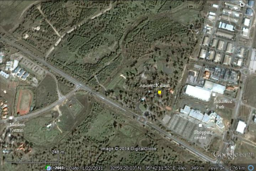
Qasrin
 Qatzrin on govmap.gov.il
click on image to explore this site on a new tab in govmap.gov.il
| Transliterated Name | Source | Name |
|---|---|---|
| Katzrin | Hebrew | קַצְרִין |
| Qatzrin | Arabic | قصرين |
| Qasrin, Kasrin | other spelling variants | |
- Qatzrin in Google Earth
 Qatzrin
click on image to explore this site on a new tab in Google Earth - Qatzrin on govmap.gov.il
 Qatzrin on govmap.gov.il
click on image to explore this site on a new tab in govmap.gov.il - Annotated Aerial View of Qatzrin
from BibleWalks.com
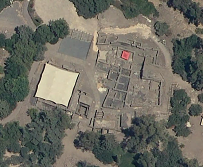
- Aerial View of excavated
Synagogue/Mosque from Moaz and Killebrew (1988)
 The synagogue as viewed from the west in 1983. Note the thirteenth-century platform outside of the mosque;
this was used for prayer in the summer. Photograph by Zvi Macoz.
The synagogue as viewed from the west in 1983. Note the thirteenth-century platform outside of the mosque;
this was used for prayer in the summer. Photograph by Zvi Macoz.
Moaz and Killebrew (1988) - Aerial View of excavated Village
at Qasrin from Moaz and Killebrew (1988)
 Aerial View of excavated Village
Moaz and Killebrew (1988)
- Plan of the Synagogue from
Stern et. al. (1993 v.4)
 Plan of the Synagogue
Stern et. al. (1993 v.4) - Plan of the Village from
Stern et. al. (1993 v.4)
 Plan of the Village
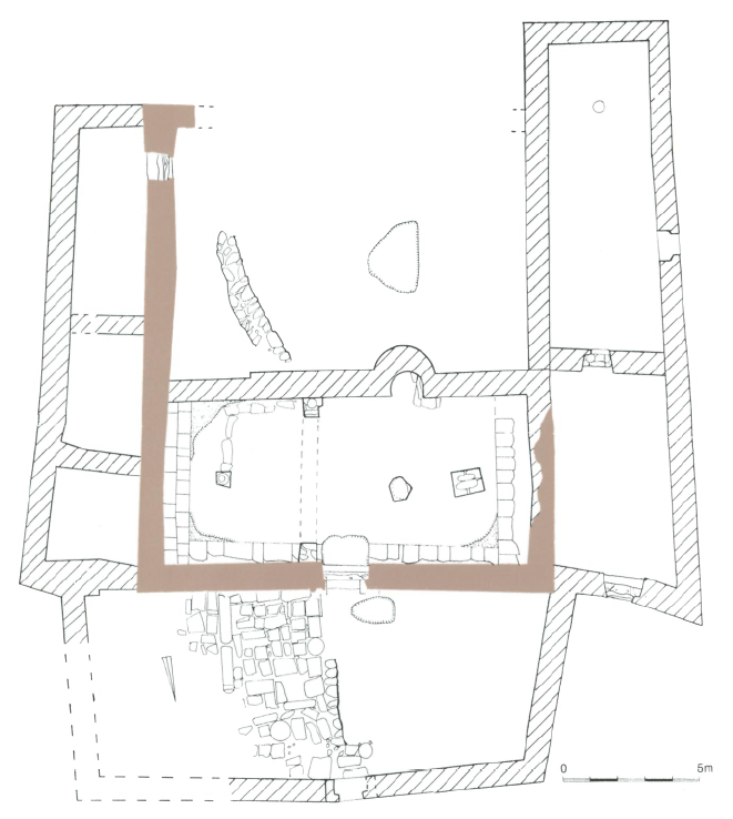
Stern et. al. (1993 v.4) - Plan of Houses A, B, and C
and Synagogue B from Moaz and Killebrew (1988)

In order to gain a better understanding of the wider cultural context of the synagogue, a 1,200-squaie-meter segment east of it has been opened to excavation. Thus far a small public square, three domestic buildings, three industrial rooms, and four alleys have been identified, with only house A having been completely excavated. House A is a small two-room dwelling; its large room was built shortly after the construction of synagogue A and its small room was added in the fifth or sixth century C.E. Alleys separate house A from B and C, and B and C from each other. Four large rooms of house B have been excavated; all of these appear to be additions to an original house, the main part of which lies south of the current excavation boundaries. 7b the east of the four rooms is a courtyard divided into different activity areas by an L-shaped wall. Apparently this house was enlarged and remodeled over several generations. House C, which covers an area of 500 square meters and which extends to the east beyond the current limits of excavation, is actually several structures that were joined together. The com¬plex was occupied in the Byzantine period and later, and it includes, in the northeast section of the excavation area, several rooms that surround the point at which an underground spring comes to the surface. It is clear from what has been excavated thus far that, in contrast to the synagogue, which has three stratigraphically definable construction phases that can be under¬stood in terms of community needs, the Byzantine village developed organically according to the needs of the occupants of each structure.
Moaz and Killebrew (1988) - Simplified Plan of Synagogue B
from Moaz and Killebrew (1988)
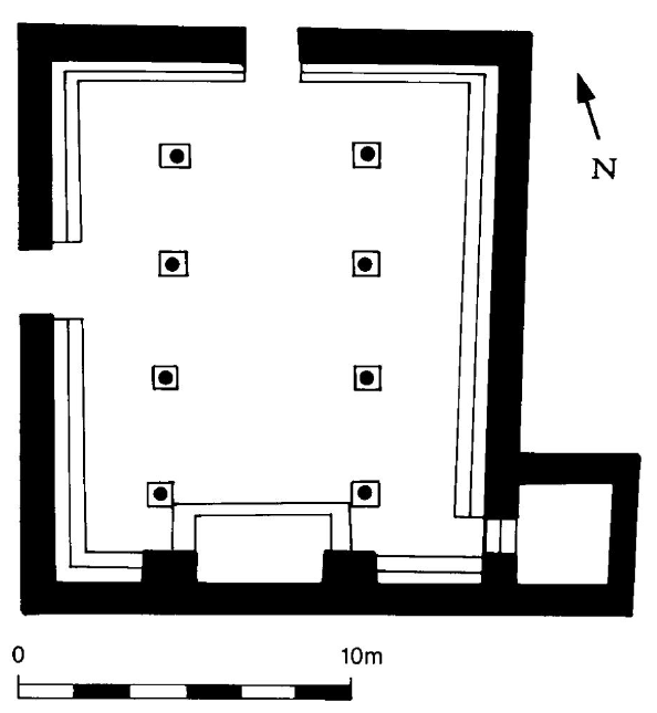 Simplified plan of the synagogue B at Qasrin. Synagogue B made use of the foundations of the
south, west, and east walls of synagogue A, but the latter two were lengthened to the north and a new foundation for the
north wall was put in place. Note the two-stepped ashlar benches along all four walls, the small annex room, the platform
for a Torah shrine on the south wall (so that prayers could be directed toward Jerusalem), and the main entrance on the
north wall.
Simplified plan of the synagogue B at Qasrin. Synagogue B made use of the foundations of the
south, west, and east walls of synagogue A, but the latter two were lengthened to the north and a new foundation for the
north wall was put in place. Note the two-stepped ashlar benches along all four walls, the small annex room, the platform
for a Torah shrine on the south wall (so that prayers could be directed toward Jerusalem), and the main entrance on the
north wall.
Moaz and Killebrew (1988) - Plan of destruction debris in
Synagogue B from Moaz and Killebrew (1988)

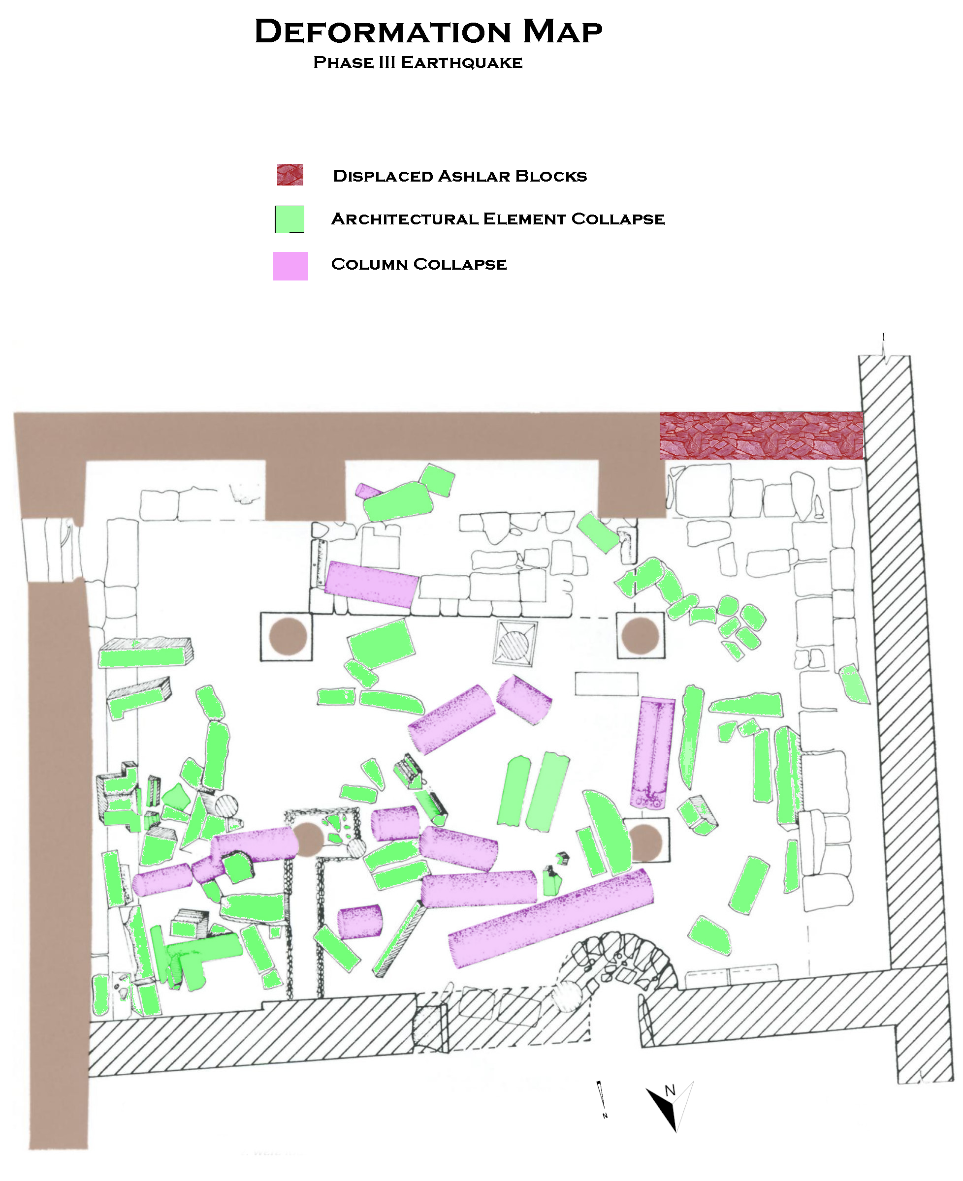
Synagogue B was destroyed by an earthquake, as revealed by the relatively undisturbed destruction debris in its southern section. Note that two column bases of the western row (on the right) and two of the eastern row were found in situ and that most of the architectural members fell in the same direction - towards the northeast: The columns of the western row, including one column shaft 3.7 meters long, were found in the floor of the nave, while those of the eastern row had collapsed into the eastern aisle, with window fragments from the clerestory resting on the benches along the wall. Such a regular pattern of destruction is typical of earthquakes. The destruction has been dated to the eighth century on the basis of pottery sherds from that period found in undisturbed places beneath the destruction layer. The semicircular installation in the wall at the bottom of the drawing is the mihrab of the mosque that was built in the northern part of the structure in the thirteenth century. Walls marked with solid black were original, while those marked with hatching were built for the mosque. Drawing is by M. Feist and A. Kranz
Moaz and Killebrew (1988) - Plan of Mameluke Mosque (~13th c. CE)
from Moaz and Killebrew (1988)
 Plan of the mosque built during the Mamluk period (approximately the thirteenth century C.E.) in the northern section of the ruined synagogue
Drawing by A. Kranz.br>
Moaz and Killebrew (1988)
- Plan of the Synagogue from
Stern et. al. (1993 v.4)
Plan of the Synagogue
Stern et. al. (1993 v.4) - Plan of the Village from
Stern et. al. (1993 v.4)
Plan of the Village
Stern et. al. (1993 v.4) - Plan of Houses A, B, and C
and Synagogue B from Moaz and Killebrew (1988)
In order to gain a better understanding of the wider cultural context of the synagogue, a 1,200-squaie-meter segment east of it has been opened to excavation. Thus far a small public square, three domestic buildings, three industrial rooms, and four alleys have been identified, with only house A having been completely excavated. House A is a small two-room dwelling; its large room was built shortly after the construction of synagogue A and its small room was added in the fifth or sixth century C.E. Alleys separate house A from B and C, and B and C from each other. Four large rooms of house B have been excavated; all of these appear to be additions to an original house, the main part of which lies south of the current excavation boundaries. 7b the east of the four rooms is a courtyard divided into different activity areas by an L-shaped wall. Apparently this house was enlarged and remodeled over several generations. House C, which covers an area of 500 square meters and which extends to the east beyond the current limits of excavation, is actually several structures that were joined together. The com¬plex was occupied in the Byzantine period and later, and it includes, in the northeast section of the excavation area, several rooms that surround the point at which an underground spring comes to the surface. It is clear from what has been excavated thus far that, in contrast to the synagogue, which has three stratigraphically definable construction phases that can be under¬stood in terms of community needs, the Byzantine village developed organically according to the needs of the occupants of each structure.
Moaz and Killebrew (1988) - Plan of destruction debris in
Synagogue B from Moaz and Killebrew (1988)
Synagogue B was destroyed by an earthquake, as revealed by the relatively undisturbed destruction debris in its southern section. Note that two column bases of the western row (on the right) and two of the eastern row were found in situ and that most of the architectural members fell in the same direction - towards the northeast: The columns of the western row, including one column shaft 3.7 meters long, were found in the floor of the nave, while those of the eastern row had collapsed into the eastern aisle, with window fragments from the clerestory resting on the benches along the wall. Such a regular pattern of destruction is typical of earthquakes. The destruction has been dated to the eighth century on the basis of pottery sherds from that period found in undisturbed places beneath the destruction layer. The semicircular installation in the wall at the bottom of the drawing is the mihrab of the mosque that was built in the northern part of the structure in the thirteenth century. Walls marked with solid black were original, while those marked with hatching were built for the mosque. Drawing is by M. Feist and A. Kranz
Moaz and Killebrew (1988) - Plan of Mameluke Mosque
(~13th c. CE) from Moaz and Killebrew (1988)
Plan of the mosque built during the Mamluk period (approximately the thirteenth century C.E.) in the northern section of the ruined synagogue
Drawing by A. Kranz.br>
Moaz and Killebrew (1988)
- Displaced ashlars in NW
(exterior ?) corner of synagogue from Stern et al. (1993 v.4)
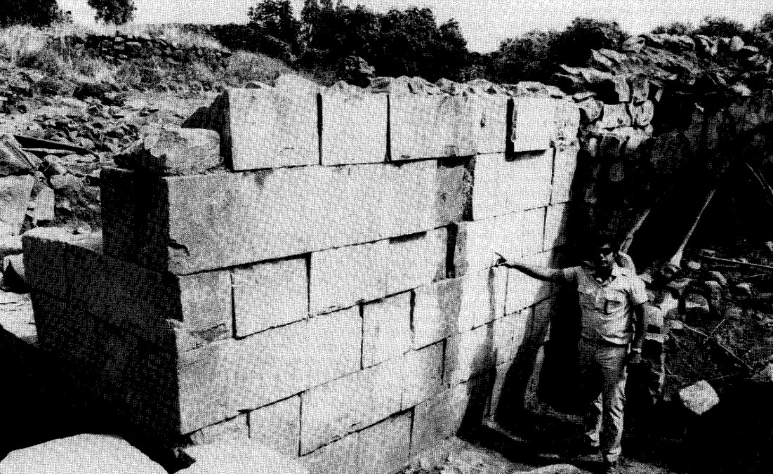 Ashlar construction in the northwest corner of the Synagogue
JW: Ashlars are displaced
click on image to open in a new tab
Zvi Uri Moaz in Stern et al. (1993) - Displaced Columns
from Manar Al-Athar (Oxford University)
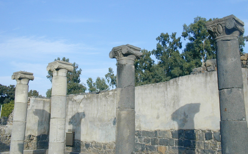 Photo 05
Column to far right exhibits displaced masonry blocks
click on image to open in a new tab
Manar Al-Athar website (Oxford University) - Displaced Columns
from Manar Al-Athar (Oxford University)
 Photo 06
Some masonry block column displacement in nearest and farthest columns
click on image to open in a new tab
Manar Al-Athar website (Oxford University) - Fig. 3.2 aerial view
of the Qaṣrin synagogue and village from Betlyon and Killebrew (2016)
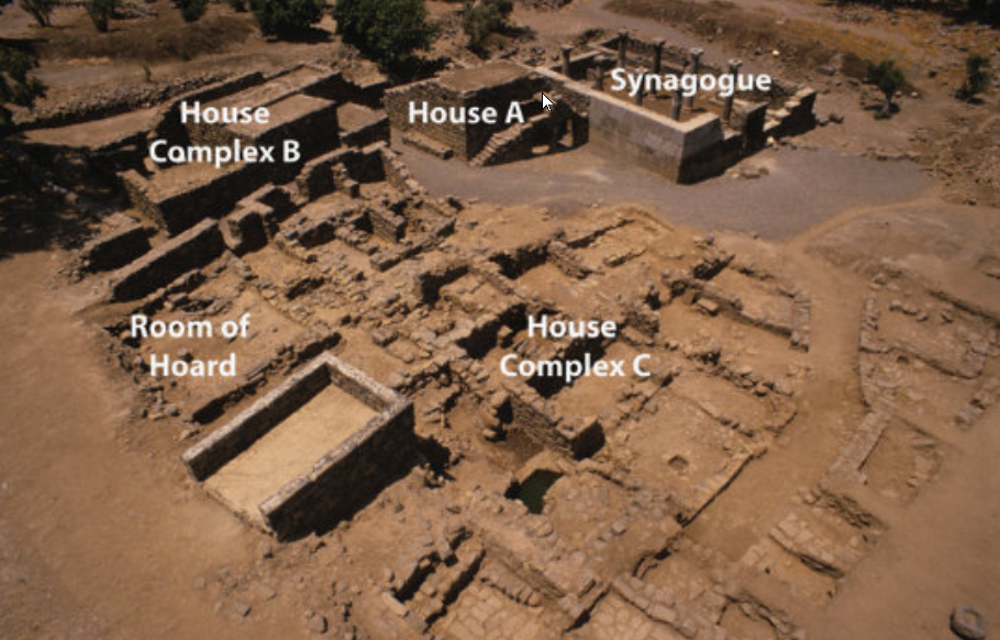 Fig. 3.2
An aerial view of the Qaṣrin synagogue and village. (Photo by Ann E. Killebrew.)
click on image to open in a new tab
Betlyon and Killebrew (2016)
- Displaced ashlars in NW
(exterior ?) corner of synagogue from Stern et al. (1993 v.4)
Ashlar construction in the northwest corner of the Synagogue
JW: Ashlars are displaced
click on image to open in a new tab
Zvi Uri Moaz in Stern et al. (1993) - Displaced Columns
from Manar Al-Athar (Oxford University)
Photo 05
Column to far right exhibits displaced masonry blocks
click on image to open in a new tab
Manar Al-Athar website (Oxford University) - Displaced Columns
from Manar Al-Athar (Oxford University)
Photo 06
Some masonry block column displacement in nearest and farthest columns
click on image to open in a new tab
Manar Al-Athar website (Oxford University) - Fig. 3.2 aerial view
of the Qaṣrin synagogue and village from Betlyon and Killebrew (2016)
Fig. 3.2
An aerial view of the Qaṣrin synagogue and village. (Photo by Ann E. Killebrew.)
click on image to open in a new tab
Betlyon and Killebrew (2016)
- Plan of destruction debris in
Synagogue B from Moaz and Killebrew (1988)
Synagogue B was destroyed by an earthquake, as revealed by the relatively undisturbed destruction debris in its southern section. Note that two column bases of the western row (on the right) and two of the eastern row were found in situ and that most of the architectural members fell in the same direction - towards the northeast: The columns of the western row, including one column shaft 3.7 meters long, were found in the floor of the nave, while those of the eastern row had collapsed into the eastern aisle, with window fragments from the clerestory resting on the benches along the wall. Such a regular pattern of destruction is typical of earthquakes. The destruction has been dated to the eighth century on the basis of pottery sherds from that period found in undisturbed places beneath the destruction layer. The semicircular installation in the wall at the bottom of the drawing is the mihrab of the mosque that was built in the northern part of the structure in the thirteenth century. Walls marked with solid black were original, while those marked with hatching were built for the mosque. Drawing is by M. Feist and A. Kranz
Moaz and Killebrew (1988) - Plan of Houses A, B, and C
and Synagogue B from Moaz and Killebrew (1988)
In order to gain a better understanding of the wider cultural context of the synagogue, a 1,200-squaie-meter segment east of it has been opened to excavation. Thus far a small public square, three domestic buildings, three industrial rooms, and four alleys have been identified, with only house A having been completely excavated. House A is a small two-room dwelling; its large room was built shortly after the construction of synagogue A and its small room was added in the fifth or sixth century C.E. Alleys separate house A from B and C, and B and C from each other. Four large rooms of house B have been excavated; all of these appear to be additions to an original house, the main part of which lies south of the current excavation boundaries. 7b the east of the four rooms is a courtyard divided into different activity areas by an L-shaped wall. Apparently this house was enlarged and remodeled over several generations. House C, which covers an area of 500 square meters and which extends to the east beyond the current limits of excavation, is actually several structures that were joined together. The com¬plex was occupied in the Byzantine period and later, and it includes, in the northeast section of the excavation area, several rooms that surround the point at which an underground spring comes to the surface. It is clear from what has been excavated thus far that, in contrast to the synagogue, which has three stratigraphically definable construction phases that can be under¬stood in terms of community needs, the Byzantine village developed organically according to the needs of the occupants of each structure.
Moaz and Killebrew (1988)
| Effect | Location | Image(s) | Description |
|---|---|---|---|
| Displaced Masonry Blocks | Northwest Wall of Synagogue B
Plan of the Synagogue Stern et. al. (1993 v.4)
Moaz and Killebrew (1988) |
Ashlar construction in the northwest corner of the Synagogue Zvi Uri Moaz in Stern et al (1993) |
from Zvi Uri Ma'oz in Stern et al (1993) |
| Collapsed Walls | Synagogue B
Plan of the Synagogue Stern et. al. (1993 v.4)
Moaz and Killebrew (1988) |
Moaz and Killebrew (1988) |
Some wall collapse seems to be indicated from the stone tumble in Synagogue B - from Moaz and Killebrew (1988) |
| Fallen and Oriented Columns | Synagogue B
Plan of the Synagogue Stern et. al. (1993 v.4)
Moaz and Killebrew (1988) |
Moaz and Killebrew (1988) |
Note that two column bases of the western row (on the right) and two of the eastern row were found in situ and that most of the architectural members fell in the same direction - towards the northeast: The columns of the western row, including one column shaft 3.7 meters long, were found in the floor of the nave, while those of the eastern row had collapsed into the eastern aisle, with window fragments from the clerestory resting on the benches along the wall. Such a regular pattern of destruction is typical of earthquakes.- Moaz and Killebrew (1988) |
| Stone Tumble and debris | House C
Moaz and Killebrew (1988) |
House C contained a destruction layer consisting of massive stone tumble and debris on top of the upper pavement - from Moaz and Killebrew (1988) | |
| Displaced Columns ? (unsure what was restored in these photos) |
Synagogue
Plan of the Synagogue Stern et. al. (1993 v.4)
Moaz and Killebrew (1988) |
Photo 05 Column to far right exhibits displaced masonry blocks Manar Al-Athar website (Oxford University - see references for link)
Photo 06Some masonry block column displacement in nearest and farthest columns Manar Al-Athar website (Oxford University - see references for link) |
JW: Column displacement is possible, as seen at other sites such as Jerash, but at present the displacement is undated and the degree of restoration is unknown. Some or all columns may have been reset into vertical positions after the earthquake, making it unclear how much of the original seismic displacement is preserved. |
- Modified by JW from Moaz and Killebrew (1988)
- Column falls show a NE orientation
 Deformation Map
click on image to open a higher resolution magnifiable image in a new tab
modified by JW from Moaz and Killebrew (1988)
- Earthquake Archeological Effects chart
of Rodríguez-Pascua et al (2013: 221-224)
 Earthquake Archeological Effects (EAE)
Rodríguez-Pascua et al (2013: 221-224)
| Effect | Location | Image(s) | Description | Intensity |
|---|---|---|---|---|
| Displaced Masonry Blocks | Northwest Wall of Synagogue B
Plan of the Synagogue Stern et. al. (1993 v.4)
Moaz and Killebrew (1988) |
Ashlar construction in the northwest corner of the Synagogue Zvi Uri Moaz in Stern et al (1993) |
from Zvi Uri Ma'oz in Stern et al (1993) | VIII + |
| Collapsed Walls | Synagogue B
Plan of the Synagogue Stern et. al. (1993 v.4)
Moaz and Killebrew (1988) |
Moaz and Killebrew (1988) |
Some wall collapse seems to be indicated from the stone tumble in Synagogue B - from Moaz and Killebrew (1988) | VIII + |
| Fallen and Oriented Columns | Synagogue B
Plan of the Synagogue Stern et. al. (1993 v.4)
Moaz and Killebrew (1988) |
Moaz and Killebrew (1988) |
Note that two column bases of the western row (on the right) and two of the eastern row were found in situ and that most of the architectural members fell in the same direction - towards the northeast: The columns of the western row, including one column shaft 3.7 meters long, were found in the floor of the nave, while those of the eastern row had collapsed into the eastern aisle, with window fragments from the clerestory resting on the benches along the wall. Such a regular pattern of destruction is typical of earthquakes.- Moaz and Killebrew (1988) |
V + |
| Stone Tumble and debris which suggests wall collapse | House C
Moaz and Killebrew (1988) |
House C contained a destruction layer consisting of massive stone tumble and debris on top of the upper pavement - from Moaz and Killebrew (1988) | VIII + | |
| Displaced Columns ? (unsure what was restored in these photos) |
Synagogue
Plan of the Synagogue Stern et. al. (1993 v.4)
Moaz and Killebrew (1988) |
Photo 05 Column to far right exhibits displaced masonry blocks Manar Al-Athar website (Oxford University - see references for link)
Photo 06Some masonry block column displacement in nearest and farthest columns Manar Al-Athar website (Oxford University - see references for link) |
JW: Column displacement is possible, as seen at other sites such as Jerash, but at present the displacement is undated and the degree of restoration is unknown. Some or all columns may have been reset into vertical positions after the earthquake, making it unclear how much of the original seismic displacement is preserved. | VIII + |
most of the architectural members fell in the same direction - towards the northeast.