Kedesh
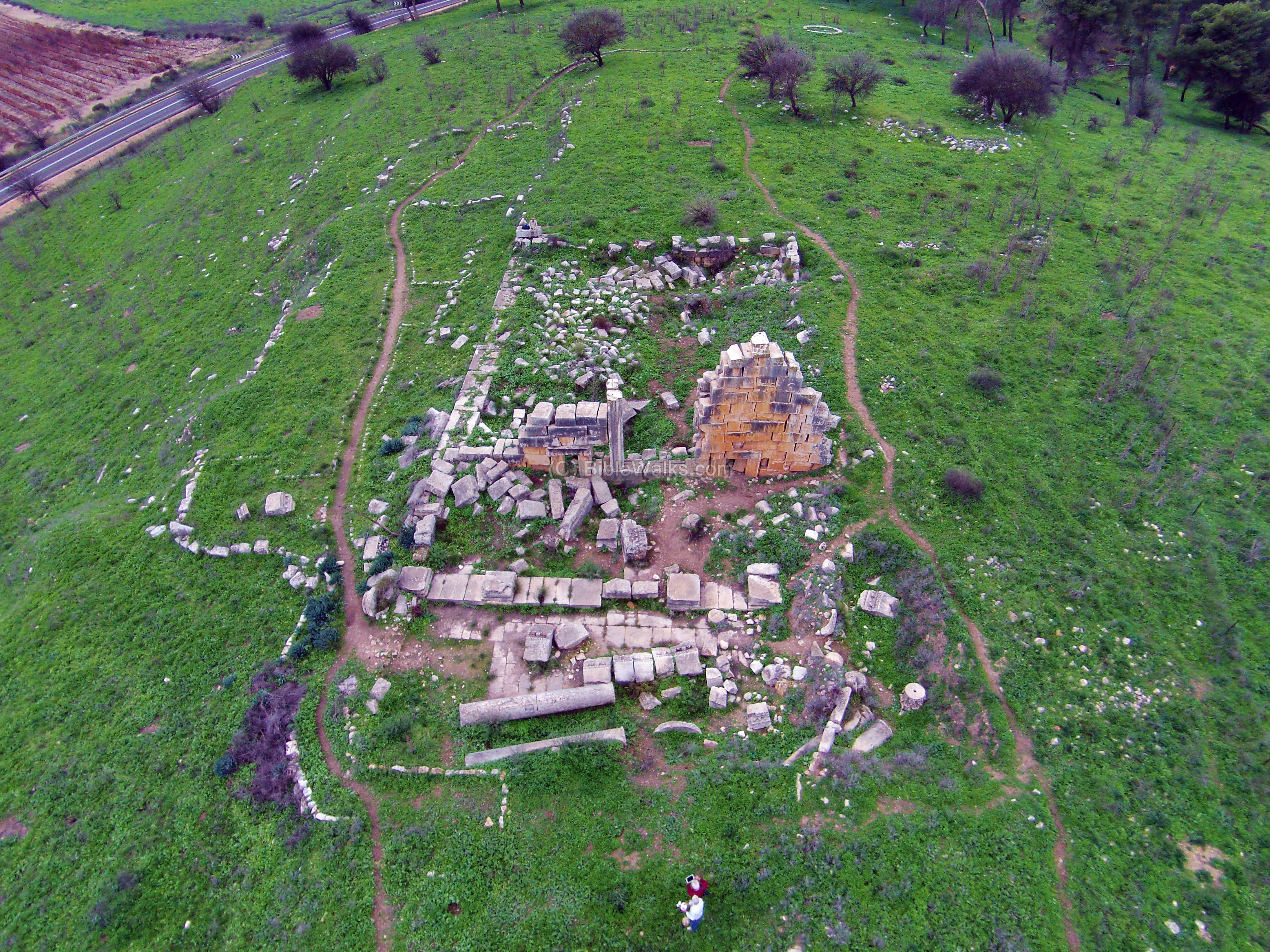 Aerial Photo of the remains of the Roman Temple at Kedesh (view from the East)
Click on Image for high resolution magnifiable image
Used with permission from BibleWalks.com
| Transliterated Name | Source | Name |
|---|---|---|
| Kedesh | Hebrew | קדש |
| Khirbet Qadish | Arabic | كهيربيت قاديسه |
| Kades | Arabic | قاديس |
| Qades | Arabic | قاديس |
| Cadesh | ||
| Cydessa | ||
| Cadasa | ||
| Kydissos | Ancient Greek | Κυδισσός |
- Fig. 1 Location Map
from Wachtel & Davidovich (2021)
 Figure 1
Topographic model of Northern Canaan showing the location of Qedesh and other EBA sites mentioned in the text. Geological exposures of the Hatira Formation are marked by red polygons.
Wachtel & Davidovich (2021) - Location Map from
biblewalks.com
 Biblical Map: Area around Kedesh – Canaanite through roman periods
(based on Bible Mapper 3.0)
Used with permission from from biblewalks.com
- Fig. 1 Location Map
from Wachtel & Davidovich (2021)
Figure 1
Topographic model of Northern Canaan showing the location of Qedesh and other EBA sites mentioned in the text. Geological exposures of the Hatira Formation are marked by red polygons.
Wachtel & Davidovich (2021) - Location Map from
biblewalks.com
Biblical Map: Area around Kedesh – Canaanite through roman periods
(based on Bible Mapper 3.0)
Used with permission from from biblewalks.com
- Fig. 2 Wide Aerial View of
Kedesh and surroundings from Wachtel & Davidovich (2021)
 Figure 2
. Isometric Google Earth view of Qedesh, Hula Valley, and northeastern Galilee, looking northwest
Wachtel & Davidovich (2021) - Fig. 2 Aerial View of the
Mounds of Kedesh from Wachtel & Davidovich (2021)
 Figure 3
The site of Qedesh and its various components, shown in a 1945 aerial photo with the village of Qadas on the upper mound, looking northwest. The cross-section (lower left) runs through the straight line marked on the photo.
Wachtel & Davidovich (2021) - Fig. 1 Aerial View of the
Mounds of Kedesh from Davidovich and Wachtel (2022)
 Figure 1
The boundaries of the site based on the survey results, and the excavation areas superimposed on a British aerial photograph from 1945 (RAF PS 30 Jan 1945, F12, 5097)
Davidovich and Wachtel (2022) - Annotated Satellite View
of the area from biblewalks.com
- Kedesh in Google Earth
 Kedesh
click on image to explore this site on a new tab in Google Earth - Kedesh on govmap.gov.il
 Kedesh
click on image to explore this site on a new tab in govmap.gov.il - Roman Temple at Kedesh in Google Earth
 Roman Temple at Kedesh
click on image to explore this site on a new tab in Google Earth - Roman Temple at Kedesh on govmap.gov.il
 Roman Temple at Kedesh
click on image to explore this site on a new tab in govmap.gov.il

- Fig. 2 Wide Aerial View of
Kedesh and surroundings from Wachtel & Davidovich (2021)
Figure 2
. Isometric Google Earth view of Qedesh, Hula Valley, and northeastern Galilee, looking northwest
Wachtel & Davidovich (2021) - Fig. 2 Aerial View of the
Mounds of Kedesh from Wachtel & Davidovich (2021)
Figure 3
The site of Qedesh and its various components, shown in a 1945 aerial photo with the village of Qadas on the upper mound, looking northwest. The cross-section (lower left) runs through the straight line marked on the photo.
Wachtel & Davidovich (2021) - Fig. 1 Aerial View of the
Mounds of Kedesh from Davidovich and Wachtel (2022)
Figure 1
The boundaries of the site based on the survey results, and the excavation areas superimposed on a British aerial photograph from 1945 (RAF PS 30 Jan 1945, F12, 5097)
Davidovich and Wachtel (2022) - Annotated Staellite View
of the area from biblewalks.com
- Plan of the Roman Temple
in Kedesh from Stern et al (1993 v. 3)
 Plan of the Roman Temple in Kedesh
Stern et al (1993 v. 3) - Plan of 'a Masonry Tomb'
in Kedesh (Kades) from Conder and Kitchner (1882:228)
 Plan of 'a Masonry Tomb' in Kedesh
Conder and Kitchner (1882:228)
- Plan of the Roman Temple
in Kedesh from Stern et al (1993 v. 3)
Plan of the Roman Temple in Kedesh
Stern et al (1993 v. 3) - Plan of 'a Masonry Tomb'
in Kedesh (Kades) from Conder and Kitchner (1882:228)
Plan of 'a Masonry Tomb' in Kedesh
Conder and Kitchner (1882:228)
| Effect | Location | Image(s) | Description |
|---|---|---|---|
| Displaced Masonry Blocks and Rotated Blocks | Roman Temple in Kedesh
Plan of the Roman Temple in Kedesh Stern et al (1993) |
Fig. 3 a-d
 Figure 3
Schweppe et al (2017)  South Side Doorway
west view from the inner side of the temple. The south doorway is on the right side, while the doorpost of the main entrance is seen on the left side. Note that the other opening between the doorways was caused by fallen stones. Used with permission from BibleWalks.com  South Side Doorway
seen from the eastern exterior side Used with permission from BibleWalks.com  South Side Doorway
closeup on the decorated lintel above the southern doorway JW: note the rotated block above the lintel Used with permission from BibleWalks.com |
|
| Folded Walls | Roman Temple at Kedesh
Plan of the Roman Temple in Kedesh Stern et al (1993) |
Fig. 3b
Figure 3
Schweppe et al (2017) |
JW: Wall shown in Fig. 3b shows a "gap between two shells" and is folded |
| Fallen and oriented columns | Roman Temple at Kedesh
Plan of the Roman Temple in Kedesh Stern et al (1993) |
JW: three columns fell in the same direction on the eastern front of the temple | |
| Arch Damage - Keystones | keystones above the two side entrances at the Roman Temple in Kedesh
Plan of the Roman Temple in Kedesh Stern et al (1993) |
|
|
| Arch Damage - Dropped Keystone | Masonry Tomb at Kades
Plan of 'a Masonry Tomb' in Kedesh Conder and Kitchner (1882:228) |
 Masonry Tomb at Kades [aka Kedesh] - levels re-balanced by Williams
Conder and Kitchner (1882:228-229) |
Conder and Kitchner (1882:228-229) took a photo described as Masonry Tomb at Kades [aka Kedesh]which shows a dropped keystone in a N-S trending arch |
- Modified by JW from Plan of the Roman Temple at Kedesh from Stern et al (1993 v. 3)
 Deformation Map
Modified by JW from Plan of the Roman Temple at Kedesh from Stern et al (1993 v. 3)
- Modified by JW from Plan of a Masonry Tomb at Kades from Conder and Kitchner (1882:228)
 Deformation Map
Modified by JW from Plan of a Masonry Tomb at Kades from Conder and Kitchner (1882:228)
-
Earthquake Archeological Effects chart
of Rodríguez-Pascua et al (2013: 221-224)
 Earthquake Archeological Effects (EAE)
Rodríguez-Pascua et al (2013: 221-224)
| Effect | Location | Image(s) | Description | Intensity |
|---|---|---|---|---|
| Displaced Masonry Blocks and Rotated Blocks | Roman Temple in Kedesh
Plan of the Roman Temple in Kedesh Stern et al (1993) |
Fig. 3 a-d
Figure 3
Schweppe et al (2017)
South Side Doorwaywest view from the inner side of the temple. The south doorway is on the right side, while the doorpost of the main entrance is seen on the left side. Note that the other opening between the doorways was caused by fallen stones. Used with permission from BibleWalks.com
South Side Doorwayseen from the eastern exterior side Used with permission from BibleWalks.com
South Side Doorwaycloseup on the decorated lintel above the southern doorway JW: note the rotated block above the lintel Used with permission from BibleWalks.com |
|
VIII+ |
| Folded Walls | Roman Temple at Kedesh
Plan of the Roman Temple in Kedesh Stern et al (1993) |
Fig. 3b
Figure 3
Schweppe et al (2017) |
JW: Wall shown in Fig. 3b shows a "gap between two shells" and is folded | VII+ |
| Fallen and oriented columns | Roman Temple at Kedesh
Plan of the Roman Temple in Kedesh Stern et al (1993) |
JW: three columns fell in the same direction on the eastern front of the temple | V+ | |
| Arch Damage - Keystones | keystones above the two side entrances at the Roman Temple in Kedesh
Plan of the Roman Temple in Kedesh Stern et al (1993) |
|
VI+ | |
| Arch Damage - Dropped Keystone | Masonry Tomb at Kades
Plan of 'a Masonry Tomb' in Kedesh Conder and Kitchner (1882:228) |
Masonry Tomb at Kades [aka Kedesh] - levels re-balanced by Williams
Conder and Kitchner (1882:228-229) |
Conder and Kitchner (1882:228-229) took a photo described as Masonry Tomb at Kades [aka Kedesh]which shows a dropped keystone in a N-S trending arch |
VI+ |
 Table 2
Parameters of two assumed earthquakes (†), five historic earthquakes along the DSTF (Dead Sea Transform Fault) and in addition a strong motion record (٭) from the 1999 Taiwan earthquake.
JW: 749 CE simulation is highlighted
Schweppe et al (2017)
Schweppe et al (2017) performed numerical simulations and estimated that a PGA of 6 m/s2 was required to topple the currently remaining Temple structure under conditions of a dominant frequency of 1 Hz. and shaking in an EW direction. This produced an estimated upper limit for strength of shaking experienced at the site - at least since around 363 CE. They additionally simulated a number of historical earthquakes thought to have affected Kedesh after 363 CE and none were shown to have toppled what remains of the Temple. They did not simulate a hypothesized 363 CE earthquake (363 CE Cyril Quakes) which may have led to or contributed to initial abandonment of the structure.
In their simulation of post 363 CE earthquakes (Table 2 above), the Southern 749 CE Sabbatical Year Quake highlighted yellow in the table above appears to be mischaracterized and based on the flawed intensity map of Marco et al (2003: Figure 3) which amalgamated seperate mid 8th century CE earthquakes into one large event. The 749 CE simulation of Schweppe et al (2017) assumed that one earthquake in 749 CE effectively broke the entire Jordan Valley Fault and that the epicenter was ~150 km. south of Kedesh. However, the mid 8th century CE earthquake that would have caused the most damage at Kedesh was likely largely due to slippage on strike-slip and normal faults around the Sea of Galilee and in the northern part of the Jordan Valley. There is good evidence of strike-slip motion in one of the 749 CE Sabbatical Year Quakes at the nearby (~26 km. away) paleoseismic site of Bet Zeyda. This indicates that epicenter for the 749 CE event in Schweppe et al (2017)'s simulation should have been closer to the site. It may have also had a stronger E-W component than what was modeled by Schweppe et al (2017). Schweppe et al (2017)'s simulations showed that a strong E-W component is required to topple the east facing facade of the Temple.
While abandonment around the time of the northern Cyril Quake of 363 CE suggests that this earthquake damaged the Temple, the damage evidence at the site is undated and the most likely scenario is that it was caused by the northern Cyril Quake of 363 CE, one of the mid 8th century CE earthquakes, and possibly human agency. Other post 363 CE earthquakes may have also damaged the weakened structure.