Hazor
 Aerial photo of Tel Hazor. Remains of Iron and Bronze Age cities are
seen in the upper tell, and the lower tell stretches to the right and beyond the frame of this photo.
Aerial photo of Tel Hazor. Remains of Iron and Bronze Age cities are
seen in the upper tell, and the lower tell stretches to the right and beyond the frame of this photo.Wikipedia - public domain
| Transliterated Name | Source | Name |
|---|---|---|
| Hazor | Hebrew | חצור |
| Chatsôr | Hebrew | חָצוֹר |
| Tel Hazor | Hebrew | תל חצור |
| Hasōr | Ancient Greek | Άσώρ |
| Tell el-Qedah | Arabic | تل القدح |
| Tell Waqqas | Arabic |
 Fig. 4.1
Map of major archaeological and historical site in central and northern Israel and Jordan
Mazar et. al. (2020 v.1)
- Annotated Satellite Image (google)
of Hazor from biblewalks.com
 Annotated Satellite Image (google) of Hazor
Used with permission from BibleWalks.com - Aerial View of the Mound of
Hazor and surroundings from Kenyon (1978)
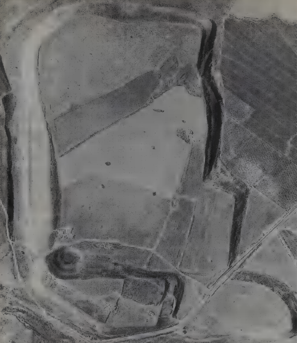
Figure 14
Aerial view of Hazor, excavated by Yadin, showing the bottle-shaped mound of the Upper City, to the south, in the foreground. It was the nucleus of the settlement on this site from the earliest occupation there through to the first millennium BC. Beyond it is the vast enclosure marking the Lower City, established sometime in the earlier second millennium BC (Middle Bronze Age), and occupied down to the early thirteenth century BC (towards the end of the Late Bronze Age).
click on image to open in a new tab
Kenyon (1978) - Hazor in Google Earth
 Hazor
Hazor
click on image to explore this site on a new tab in Google Earth - Hazor on govmap.gov.il
 Hazor
Hazor
click on image to explore this site on a new tab in govmap.gov.il
- Map of the mound,
the lower city, and excavation areas and excavation areas from Stern et al (1993 v. 2)
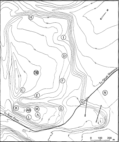 Map of the mound, the lower city, and excavation areas.
Stern et. al. (1993). - Map of the excavation
areas and principal remains of the Upper City from Stern et al (1993 v. 2)
 Map of the excavation areas and principal remains of the Upper City
Stern et al (1993 v. 2)
- Map of the mound,
the lower city, and excavation areas and excavation areas from Stern et al (1993 v. 2)
Map of the mound, the lower city, and excavation areas.
Stern et. al. (1993). - Map of the excavation
areas and principal remains of the Upper City from Stern et al (1993 v. 2)
Map of the excavation areas and principal remains of the Upper City
Stern et al (1993 v. 2)
- Aerial view of Area A
from Stern et al (2008)
 Area A: aerial view looking northwest
Stern et. al. (2008). - Close air-view of Area A
at end of 1958 season from Yadin et al (1961)
 Area A: Plate II
Looking south. Close air-view of Area A at end of 1958 season. Below, the city-gate and the casemate wall (Strata IX-X). In centre and under city-gate, structures of the Bronze Ages. Above, the pillared building (Strata VII-VIII). To its right and above it, buildings of Strata V-VI
Yadin et al (1961) - Close air-view of Area A
at end of 1957 season various from Yadin et al (1961)
 Area A: Plate III
Looking south. Close air-view of Area A at end of 1957 season. Below, the city-gate and the casemate wall (Strata IX-X). Above, the pillared building (Strata VII-VIII) and above it, buildings of Strata V-VI
Yadin et al (1961) - Aerial View of the
main Iron Age remains of the Upper City from Stern et al (1993 v. 2)
 Aerial View of the main Iron Age remains [Upper City]
Stern et al (1993 v. 2)
- Aerial view of Area A
from Stern et al (2008)
Area A: aerial view looking northwest
Stern et. al. (2008). - Close air-view of Area A
at end of 1958 season from Yadin et al (1961)
Area A: Plate II
Looking south. Close air-view of Area A at end of 1958 season. Below, the city-gate and the casemate wall (Strata IX-X). In centre and under city-gate, structures of the Bronze Ages. Above, the pillared building (Strata VII-VIII). To its right and above it, buildings of Strata V-VI
Yadin et al (1961) - Close air-view of Area A
at end of 1957 season various from Yadin et al (1961)
Area A: Plate III
Looking south. Close air-view of Area A at end of 1957 season. Below, the city-gate and the casemate wall (Strata IX-X). Above, the pillared building (Strata VII-VIII) and above it, buildings of Strata V-VI
Yadin et al (1961) - Aerial View of the
main Iron Age remains of the Upper City from Stern et al (1993 v. 2)
Aerial View of the main Iron Age remains [Upper City]
Stern et al (1993 v. 2)
- Plate XIII - Plan of Area A
Stratum VI from Yadin et al (1961)
 Plate XIII
Plan of Area A Stratum VI
Yadin et al (1961) - Fig. 48 - Plan of Area A
Stratum VI from Yadin (1970)
 Fig. 48
Area A Stratum VI
Yadin (1970) - Fig. 3 - Plan of Area A
Strata V-VIII from Shochat and Gilboa (2018)
 Figure 3
Area A at the end of Yadin’s fourth season
(1958; Yadin et al. 1961: pl. II; courtesy of The Israel Exploration Society).
Shochat and Gilboa (2018) - Fig. 6b - Plan of Area A
Stratum VI from Shochat and Gilboa (2018)
 Figure 6b
Area A, plan of Stratum VI as excavated by Yadin. The ‘Annexed Halls’ continue in use also in Stratum VI
(Yadin et al. 1960: pls CCII, CCIII; courtesy of The Israel Exploration Society).
Shochat and Gilboa (2018) - Fig. 6b - Plan of Area A
Stratum VI (closeup) from Shochat and Gilboa (2018)
 Figure 6b
Area A, plan of Stratum VI as excavated by Yadin. The ‘Annexed Halls’ continue in use also in Stratum VI
(Yadin et al. 1960: pls CCII, CCIII; courtesy of The Israel Exploration Society)
N arrow added by JW
Shochat and Gilboa (2018) - Plan of Area A from
Avi-Yonah et. al. (1975 v. 2 English version)
 Plan of Area A
Strata according to fill
- No Fill - VI
- Shaded Fill - X-XI
- Black Fill - VIII-VII
Avi-Yonah et. al. (1975) - Fig. 2 - Area A Map of
Excavation Areas from Ben-Tor (2004)
 Figure 1
Map of Excavation Areas
Ben-Tor (2004)
- Plate XIII - Plan of Area A
Stratum VI from Yadin et al (1961)
Plate XIII
Plan of Area A Stratum VI
Yadin et al (1961) - Fig. 48 - Plan of Area A
Stratum VI from Yadin (1970)
Fig. 48
Area A Stratum VI
Yadin (1970) - Fig. 3 - Plan of Area A
Strata V-VIII from Shochat and Gilboa (2018)
Figure 3
Area A at the end of Yadin’s fourth season
(1958; Yadin et al. 1961: pl. II; courtesy of The Israel Exploration Society).
Shochat and Gilboa (2018) - Fig. 6b - Plan of Area A
Stratum VI from Shochat and Gilboa (2018)
Figure 6b
Area A, plan of Stratum VI as excavated by Yadin. The ‘Annexed Halls’ continue in use also in Stratum VI
(Yadin et al. 1960: pls CCII, CCIII; courtesy of The Israel Exploration Society).
Shochat and Gilboa (2018) - Fig. 6b - Plan of Area A
Stratum VI (closeup) from Shochat and Gilboa (2018)
Figure 6b
Area A, plan of Stratum VI as excavated by Yadin. The ‘Annexed Halls’ continue in use also in Stratum VI
(Yadin et al. 1960: pls CCII, CCIII; courtesy of The Israel Exploration Society)
N arrow added by JW
Shochat and Gilboa (2018) - Plan of Area A from
Avi-Yonah et. al. (1975 v. 2 English version)
Plan of Area A
Strata according to fill
- No Fill - VI
- Shaded Fill - X-XI
- Black Fill - VIII-VII
Avi-Yonah et. al. (1975) - Fig. 2 - Area A Map of
Excavation Areas from Ben-Tor (2004)
Figure 1
Map of Excavation Areas
Ben-Tor (2004)
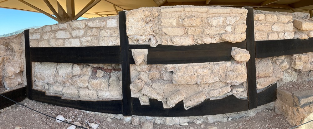
- Artists Rendition of Area A
Stratum VI Buildings from Sign at Hazor Site/Park (Solomonic Gate and Public and Private Dwellings)
 Artists Rendition Area A Stratum VI Buildings
Solomonic Gate, Public and Private Dwellings
Hazor Park/Site Sign
Photo by Jefferson Williams 17 April 2023 - Fig. 1 - Reconstruction of
Stratum VI Building from Yadin et al. (1960)
 Fig. 1
Reconstruction of Stratum VI Buildings
(Isometric Projection)
Yadin et al. (1960)
- Artists Rendition of Area A
Stratum VI Buildings from Sign at Hazor Site/Park (Solomonic Gate and Public and Private Dwellings)
Artists Rendition Area A Stratum VI Buildings
Solomonic Gate, Public and Private Dwellings
Hazor Park/Site Sign
Photo by Jefferson Williams 17 April 2023 - Fig. 1 - Reconstruction of
Stratum VI Building from Yadin et al. (1960)
Fig. 1
Reconstruction of Stratum VI Buildings
(Isometric Projection)
Yadin et al. (1960)
- Area A - Plate IX.2 -
Southward-leaning wall within Hazor Stratum VI from Yadin et al. (1960)
 Area A Plate IX 2.
Looking east. Northern wall of Locus 113 (Stratum VI) found slanting as the result of an earthquake. To left, southern wall of pillared-Building (Stratum VIII)
[Description by Austin et. al. (2000) - Southward-leaning wall within Hazor Stratum VI (Area A, Locus 113). Many walls within Stratum VI that did not collapse show significant tilt southward. The rod was oriented to vertical using the plumb line. Thickness of the wall is ~1 m (from Yadin et al., 1960, plate IX).]
Yadin et al. (1960) - Area A - Plate IX.3 -
Wall collapse within Hazor Stratum VI from Yadin et al. (1960)
 Area A Plate IX 3.
Looking west. Locus 78 (Stratum VI). In the northwest corner of this room can be seen segment of wall that collapsed as the result of an earthquake.
Yadin et al. (1960) - Area A - Plate IX.4 -
Wall after removal of collapse debris within Hazor Stratum VI from Yadin et al. (1960)
 Area A Plate IX 4.
Looking west. Same as above [Area A Plate IX 3.] after removal of wall debris. In the centre, entrance of Locus 78 (Stratum VI) blocked by stone debris. To right, slanting northern wall.
Yadin et al. (1960) - Bronze Age (Canaanite) Wall
Collapse at Tel Hazor - photo by Jefferson Williams
 Bronze Age (Canaanite) Wall Collapse at Tel Hazor
photo by Jefferson Williams from April 2023
- from Finkelstein (1999)
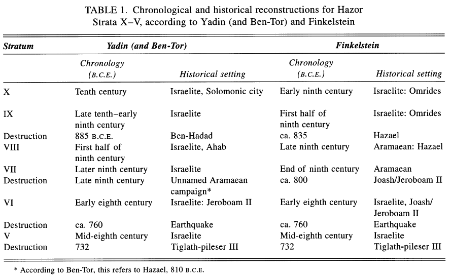 Table 1
Chronological and historical reconstructions for Hazor Strata X-V, according to Yadin (and Ben-Tor) and Finkelstein
Finkelstein (1999)
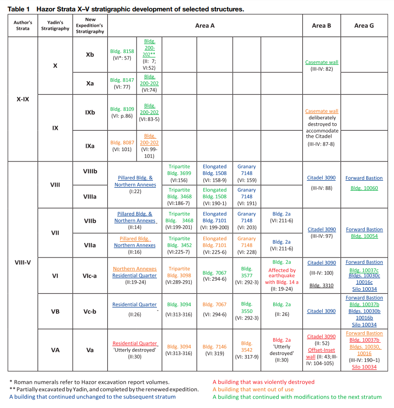 Table 1
Hazor Strata X–V stratigraphic development of selected structures.
Shochat and Gilboa (2018)
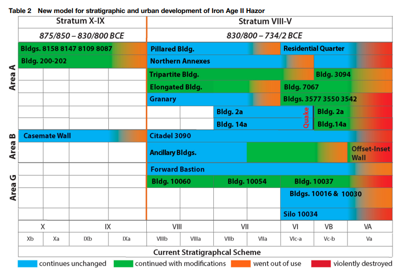 Table 2
New model for stratigraphic and urban development of Iron Age II Hazor
Shochat and Gilboa (2018)
- Area A - Plate IX.2 -
Southward-leaning wall within Hazor Stratum VI from Yadin et al. (1960)
Area A Plate IX 2.
Looking east. Northern wall of Locus 113 (Stratum VI) found slanting as the result of an earthquake. To left, southern wall of pillared-Building (Stratum VIII)
[Description by Austin et. al. (2000) - Southward-leaning wall within Hazor Stratum VI (Area A, Locus 113). Many walls within Stratum VI that did not collapse show significant tilt southward. The rod was oriented to vertical using the plumb line. Thickness of the wall is ~1 m (from Yadin et al., 1960, plate IX).]
Yadin et al. (1960) - Area A - Plate IX.3 -
Wall collapse within Hazor Stratum VI from Yadin et al. (1960)
Area A Plate IX 3.
Looking west. Locus 78 (Stratum VI). In the northwest corner of this room can be seen segment of wall that collapsed as the result of an earthquake.
Yadin et al. (1960) - Area A - Plate IX.4 -
Wall after removal of collapse debris within Hazor Stratum VI from Yadin et al. (1960)
Area A Plate IX 4.
Looking west. Same as above [Area A Plate IX 3.] after removal of wall debris. In the centre, entrance of Locus 78 (Stratum VI) blocked by stone debris. To right, slanting northern wall.
Yadin et al. (1960)
Yadin et. al. (1960) uncovered collapsed and tilted walls in Stratum VI of Area A which he dated to the 8th century BCE and before destruction of Stratum V in the Assyrian conquest in in 732 BCE. Yadin et. al. (1960:24-26) described their findings as follows:
In the 1956 season we were able to establish that Stratum VI was destroyed by an earthquake. Many walls in this stratum were found bent or cracked; in several places we found debris of walls lying course on course, just as is found in earthquakes when the entire wall collapses at once. The direction in which the walls leant or fell was southerly or easterly, according to the direction in which they ran. In some cases the upper part of the wall collapsed and the lower part remained standing but leaning. Leaning walls were used as a foundation for Stratum V when rebuilding began. Signs of the earthquake were most striking in the following rooms:Yadin et. al. (1960:36) re-iterated this in their Chronological Conclusions.
Geologists from the Hebrew University, to whom we showed these phenomena when they visited the site, confirmed our supposition that Hazor had been some distance from the epicentre of the earthquake. Strong walls had therefore stood up to the shock, while others had been only partially wrecked, even remaining standing in places, albeit at a slant. This partial destruction is seen again in the levels of the walls that survived from Stratum VI: some were preserved to a height of 2 m., others were totally wrecked.
- 78 — The N. wall was leaning to the S., and was partly supported by the debris that blocked the W. entrance to the room. Next to the wall was a sloping pile of debris made up of courses of stones; buried beneath it were several vessels (Pl. IX, 3, 4). The earthquake wrought most havoc in this room, and it was the wreckage here that first gave us the clue to the disaster.
- 14a ["The House of Makhbiram"]— The W. wall leans sharply to the E., the E. wall less so (Pl. VII, 4).
- 113 - The W. wall is cracked down the middle and leans eastwards. The N. wall leans southwards very markedly (Pl. IX, 2).
- 21a — The E. wall slants eastwards, and fallen courses of stones covered the street to the E. of the room (28a).
The damage done was repaired at once and the buildings were rebuilt. Some of them were rebuilt by the former inhabitants, to judge by the astonishing resemblance between Stratum VI and Stratum V, in which most of the buildings rose again with very slight changes. The various special installations — silos and ovens — were also rebuilt. The similarity is most striking in Room 24, in which new, almost identical silos were built on top of the old ones, and in the restoration of the special ovens in "Makhbiram's House" (made of upturned jars), although now the ovens were in another room, owing to certain changes in plan. Likewise, even in the rooms where the walls stood unaltered we found a new and raised floor, evidently built over the debris of the fallen ceilings.
Area A - Chronological Conclusions
... (b) Stratum VI. Another absolute date is provided by the earthquake that destroyed Stratum VI. Since Stratum V (see below) end with the glut destruction of 732 B.C., and Strata VIII-VII belong to the 9th century B.C. 215, it is cleat that Stratum VI belongs to the 1st half of the 8th century B.C. It can hardly be a matter of chance that precisely from this period we have records of a severe earthquake remembered for generations216. This earthquake caused widespread ruin and a general flight from the towns, reflected in the words of Zechariah: "Yea. ye shall flee, like as ye fled from before the earthquake in the days of Uzziah, king of Judah;" (XIV, 5). So deep and abiding was the memory of the disaster that events were dated from it, at we read in the Bible: "The words of Amos, who was among the herdsmen of Tekoa, which he saw concerning Israel in the days of Uzziah king of Judah, and in the days of Jeroboam the son of Joash king of Israel, two years before the earthquake." (I.1).
Thee date of this great earthquake can be fixed at about 760 B.C., and this date therefore marks the end of Stratum VI and the beginning of Stratum V.
- Figure 2 - Southward-leaning wall
within Hazor Stratum VI Area A from Austin et. al. (2000)
FIG. 2
Southward-leaning wall within Hazor Stratum VI (Area A, Locus 113). Many walls within Stratum VI that did not collapse show significant tilt southward. The rod was oriented to vertical using the plumb line. Thickness of the wall is ~1 m (from Yadin et al., 1960, plate IX).
Austin et. al. (2000) - Figure 3 - Time-stratigraphic
correlation chart of Iron IIb excavations throughout an extensive region of Israel and Jordan from Austin et. al. (2000)
 FIG. 3
Time-stratigraphic correlation chart of Iron IIb excavations throughout an extensive region of Israel and Jordan. Datum for correlation is earthquake debris or rebuilding horizons assigned to a single, 750 B.C. seismic event. Locations of cities are shown in Figure 1. Strata names at each site are from primary archaeological reports.
Symbols
- P = pottery date
- C-14 = radiocarbon date
- T = dated text material
- D = military destruction layer with historical date assigned
- A = historically dated architectural style
- E = earthquake destruction layer
- E ? = probable earthquake destruction layer (significant rebuilding horizon without evidence of military conquest)
Austin et. al. (2000)
Austin et. al. (2000) summarized 8th century BCE Archaeoseismic evidence at Hazor
Archaeological excavations at Hazor revealed graphic evidence of earthquake destruction within Stratum VI throughout Area A (Yadin et al., 1958, 1960, 1961). Walls tilted or fell in a southerly or easterly direction, roofs collapsed, and pillars inclined. The House of Makhbiram was excavated with collapsed walls (Yadin et. al., 1960, p. 19-29, 36). The building called Yael's House was excavated, with objects of daily use found beneath the collapsed ceiling. Southward-leaning walls were common near the house (Fig. 2) and characterize the orientation of the collapse debris generally. Sixteen short pillars in the adjacent courtyard were each excavated in standing position but tilted significantly from vertical (Yadin, 1975, p. 152, 153) [JW: The sixteen pillars appear to come from different older Strata (VII-VIII instead of VI). If so, they are unrelated to an 8th century BCE earthquake]. Renewed excavations within Hazor's Stratum VI by Ammon Ben-Tor unearthed further evidence of seismic destruction (Dever, 1992). The stratigraphy of the late Iron Age in Israel is summarized in Figure 3. Hazor's Stratum VI, which is terminated by debris from the severe earthquake, contains superior masonry buildings, providing evidence of prosperous economic conditions in the kingdom of Israel associated with Jeroboam II's northward expansion of ~760 B.C. into Syria (2 Kings 14:25; Yadin, 1975; Finkelstein, 1999). Stratum V, which overlies Stratum VI, contains destruction debris and a charcoal horizon marking the end of Hazor as a fortified city upon the conquest of northern Israel by Tiglath-pileser III, the king of Assyria, in 732 B.C. (2 Kings 15:29; Yadin, 1975; Finkelstein, 1999). Thus, a strong argument can be made for dating Hazor's earthquake to 760 B.C. ± 20 years, the year 760 being specified by Yadin, 1975 and Finkelstein, 1999 from their stratigraphic analysis of the destruction debris.
- Figure 6 - Map of Israelite and Phoenician cities
ca. 1500-574 BCE from Ben-Menahem (1991)
 Fig. 6
Israelite and Phoenician cities during circa 1500-574 B.C.E.
(Published with permission of Whitehouse and Whitehourse [1975, p. 103] and W.H. Freeman Publishing House)
Ben-Menahem (1991) - Figure 7 - Southward-tilting northern wall
within Hazor Stratum VI Area A from Ben-Menahem (1991)
Fig. 7
Tilting toward the south of a northern wall at Hazor, caused by the earthquake of 759 B.C.E. The direction of tilt of the shown wall and others in the same site reveal that the causative fault was to the NE of Hazor.
Ben-Menahem (1991) - Figure 8 - Horizontal shear (SH) acceleration
in the near field from Ben-Menahem (1991)
 Fig. 8
Azimuthal horizontal shear (SH) acceleration in the near field of the M = 7.3 earthquake of 759 B.C.E. Northern walls at Hazor tilted southward, while western walls tilted eastward [ Yadin et al., 1959], in accord with a left-hand strike slip fault, circa 20 km, NE of the city.
Ben-Menahem (1991)
Ben-Menahem (1991) surmised that
the location of the causative faultcould
be estimated from the oriented tilt of the walls in stratum 6 at Hazor (Figure 6), a detail of which is shown in Figure 7.He added
According to the report of the excavating archeologists [Yadin et al., 1959], northern walls were tilted southward, while western walls tilted eastward. Figure 8 shows that these orientations are consistent with the effect of a near field horizontal shear acceleration coming to Hazor from the north east. This is consistent with modern ideas that structures in the near-field of a major earthquake are mostly affected by SH body waves and the fundamental Love mode.Ben-Menahem (1991) estimated the following seismic source parameters
| Parameter | Value |
|---|---|
| ML - Local Magnitude | 7.3 |
| Fault Motion | Left Hand Strike Slip |
| Latitude | 33.0° N |
| Longitude | 35.5° E |
| Effect | Location | Image | Description |
|---|---|---|---|
| Tilted Walls and Pillars, Broken fragments of ceiling plaster | Area A - Building 2a - aka "Ya'el's House
Figure 6b Area A, plan of Stratum VI as excavated by Yadin. The ‘Annexed Halls’ continue in use also in Stratum VI (Yadin et al. 1960: pls CCII, CCIII; courtesy of The Israel Exploration Society) N arrow added by JW Shochat and Gilboa (2018) |
|
|
| Tilted Pillars | Area A - Building 2a - aka Ya'el's House
Figure 6b Area A, plan of Stratum VI as excavated by Yadin. The ‘Annexed Halls’ continue in use also in Stratum VI (Yadin et al. 1960: pls CCII, CCIII; courtesy of The Israel Exploration Society) N arrow added by JW Shochat and Gilboa (2018) |
|
Ya'el's house (named after the student who happened to supervise excavations there) is located south-west of the older pillared building and is the most beautifully planned and preserved of the Israelite structures at Hazor. We were drawn to its site upon first seeing the tops of stone pillars protruding from the ground, and these soon proved to be a row of pillars in a court of a house. The pillars were found tilted, first evidence of the earthquake. ... As it was destroyed by the terrible earthquake, not only were the pillars and walls found askance, but all the floors were littered with hundreds of pieces of ceiling plaster. There was evidence that the 'last supper of the residents, eaten just before the quake, consisted, among other things, of olives [JW:dateable if they can be found], if the many olive stones found on the floor are any indication.- Yadin (1975:152-154) |
| Collapsed Roof | Area A - Building 2a - aka Ya'el's House
Figure 6b Area A, plan of Stratum VI as excavated by Yadin. The ‘Annexed Halls’ continue in use also in Stratum VI (Yadin et al. 1960: pls CCII, CCIII; courtesy of The Israel Exploration Society) N arrow added by JW Shochat and Gilboa (2018) |
Collapsed Roof of Yael's House -
 The fallen roof of Ya'el's house
Yadin (1975) |
When we removed the accumulation of debris and the floors of Stratum V and continued descending towards the floors of the earlier strata, we were struck by two facts- Yadin (1975:151) |
| Tilted and Collapsed Walls, debris | Area A - Building 78
Figure 6b Area A, plan of Stratum VI as excavated by Yadin. The ‘Annexed Halls’ continue in use also in Stratum VI (Yadin et al. 1960: pls CCII, CCIII; courtesy of The Israel Exploration Society) N arrow added by JW Shochat and Gilboa (2018) |
|
The N. wall was leaning to the S., and was partly supported by the debris that blocked the W. entrance to the room. Next to the wall was a sloping pile of debris made up of courses of stones; buried beneath it were several vessels (Pl. IX, 3, 4). The earthquake wrought most havoc in this room, and it was the wreckage here that first gave us the clue to the disaster.- Yadin et. al. (1960:24-26) |
| Tilted Walls | Area A - Building 14a - "House of Makhbiram"
Figure 6b Area A, plan of Stratum VI as excavated by Yadin. The ‘Annexed Halls’ continue in use also in Stratum VI (Yadin et al. 1960: pls CCII, CCIII; courtesy of The Israel Exploration Society) N arrow added by JW Shochat and Gilboa (2018) |
Area A Plate VII.4 -
 Area A Plate VII.4.
Looking north-east. Group of vessels in corner of Room 14a (A 165/1; Pl. LXXIII, 17) in the "House of Makhbiram" (Stratum VI). The walls were found slanting as the result of an earthquake that destroyed the building. Yadin et al. (1960) |
The W. wall leans sharply to the E., the E. wall less so (Pl. VII, 4).- Yadin et. al. (1960:24-26) |
| Cracked and Tilted Walls | Area A - Locus 113 (Room 113)
Figure 6b Area A, plan of Stratum VI as excavated by Yadin. The ‘Annexed Halls’ continue in use also in Stratum VI (Yadin et al. 1960: pls CCII, CCIII; courtesy of The Israel Exploration Society) N arrow added by JW Shochat and Gilboa (2018) |
Area A Plate IX.2 -
Area A Plate IX 2. Looking east. Northern wall of Locus 113 (Stratum VI) found slanting as the result of an earthquake. To left, southern wall of pillared-Building (Stratum VIII) [Description by Austin et. al. (2000) - Southward-leaning wall within Hazor Stratum VI (Area A, Locus 113). Many walls within Stratum VI that did not collapse show significant tilt southward. The rod was oriented to vertical using the plumb line. Thickness of the wall is ~1 m (from Yadin et al., 1960, plate IX).] Yadin et al. (1960) |
|
| Tilted and Collapsed Walls | Area A - Room 21a
Figure 6b Area A, plan of Stratum VI as excavated by Yadin. The ‘Annexed Halls’ continue in use also in Stratum VI (Yadin et al. 1960: pls CCII, CCIII; courtesy of The Israel Exploration Society) N arrow added by JW Shochat and Gilboa (2018) |
The E. wall slants eastwards, and fallen courses of stones covered the street to the E. of the room (28a).- Yadin et. al. (1960:24-26) |
|
| Collapsed Roof | Area A
Figure 6b Area A, plan of Stratum VI as excavated by Yadin. The ‘Annexed Halls’ continue in use also in Stratum VI (Yadin et al. 1960: pls CCII, CCIII; courtesy of The Israel Exploration Society) N arrow added by JW Shochat and Gilboa (2018) |
Fragment of a Ceiling with Reed Impressions -
 Fragment of a ceiling with Reed Impressions
Yadin (1975) |
When we removed the accumulation of debris and the floors of Stratum V and continued descending towards the floors of the earlier strata, we were struck by two facts- Yadin (1975:151) |
| Broken Jars under Collapsed Roof | Area A
Figure 6b Area A, plan of Stratum VI as excavated by Yadin. The ‘Annexed Halls’ continue in use also in Stratum VI (Yadin et al. 1960: pls CCII, CCIII; courtesy of The Israel Exploration Society) N arrow added by JW Shochat and Gilboa (2018) |
Broken Jars beneath a collapsed roof -
 Jars under a fallen roof in Stratum VI
Yadin (1975) |
When we removed the accumulation of debris and the floors of Stratum V and continued descending towards the floors of the earlier strata, we were struck by two facts- Yadin (1975:150) |
| Broken Jars | Area A Bldg. 2a
Figure 6b Area A, plan of Stratum VI as excavated by Yadin. The ‘Annexed Halls’ continue in use also in Stratum VI (Yadin et al. 1960: pls CCII, CCIII; courtesy of The Israel Exploration Society) N arrow added by JW Shochat and Gilboa (2018) |
Crushed Vessels in storeroom of Bldg. 2a -
 Plate XXVI.2
Vessels in Storeroom of Building 2a, Locus 83a (Stratum VI); Looking East see drawings in Pls. CLXXXI-CLXXXVIII Yadin (1961) |
|
| ? | Area A ? - Room 148
Figure 6b Area A, plan of Stratum VI as excavated by Yadin. The ‘Annexed Halls’ continue in use also in Stratum VI (Yadin et al. 1960: pls CCII, CCIII; courtesy of The Israel Exploration Society) N arrow added by JW Shochat and Gilboa (2018) |
In room 148, built in a room of an older casemate wall, they found “great blocks of fallen bricks,” which Yadin surmised were found from the earlier city wall and reused, “from beneath which were visible fragments of many vessels” from walls built above the remaining height of the casemate walls. “The rest of the room was full of jars and other vessels, standing side by side and smashed to bits by the fallen roof,” a hypothesis that Yadin supports by explaining that “[they] managed to restore most of them, which shows that the roof fell in suddenly- Danzig (2011:19) quoting Yadin (1960:143) except Yadin (1960:143) contains no such passage and refers to Area F Stratum IA. |
|
| Fallen ceiling plaster | Area A - Room 82a
Figure 6b Area A, plan of Stratum VI as excavated by Yadin. The ‘Annexed Halls’ continue in use also in Stratum VI (Yadin et al. 1960: pls CCII, CCIII; courtesy of The Israel Exploration Society) N arrow added by JW Shochat and Gilboa (2018) |
In Building 2a, “all the floors were littered with hundreds of pieces of ceiling plaster,” including a large chunk in room 82a- Danzig (2011:19) quoting Yadin - possibly Yadin (1960). 82a is in the same structure as Ya'el's House (2a). |


- Modified by JW from Fig. 6b of Shochat and Gilboa (2018)
 Deformation Map
Modified by JW from Fig. 6b of Shochat and Gilboa (2018)
- Earthquake Archeological Effects chart
of Rodríguez-Pascua et al (2013: 221-224)
 Earthquake Archeological Effects (EAE)
Rodríguez-Pascua et al (2013: 221-224)
| Effect | Location | Image | Description | Intensity |
|---|---|---|---|---|
| Tilted Walls and Pillars, Broken fragments of ceiling plaster | Area A - Building 2a - aka "Ya'el's House
Figure 6b Area A, plan of Stratum VI as excavated by Yadin. The ‘Annexed Halls’ continue in use also in Stratum VI (Yadin et al. 1960: pls CCII, CCIII; courtesy of The Israel Exploration Society) N arrow added by JW Shochat and Gilboa (2018) |
|
|
VI+ |
| Tilted Pillars | Area A - Building 2a - aka Ya'el's House
Figure 6b Area A, plan of Stratum VI as excavated by Yadin. The ‘Annexed Halls’ continue in use also in Stratum VI (Yadin et al. 1960: pls CCII, CCIII; courtesy of The Israel Exploration Society) N arrow added by JW Shochat and Gilboa (2018) |
|
Ya'el's house (named after the student who happened to supervise excavations there) is located south-west of the older pillared building and is the most beautifully planned and preserved of the Israelite structures at Hazor. We were drawn to its site upon first seeing the tops of stone pillars protruding from the ground, and these soon proved to be a row of pillars in a court of a house. The pillars were found tilted, first evidence of the earthquake. ... As it was destroyed by the terrible earthquake, not only were the pillars and walls found askance, but all the floors were littered with hundreds of pieces of ceiling plaster. There was evidence that the 'last supper of the residents, eaten just before the quake, consisted, among other things, of olives [JW:dateable if they can be found], if the many olive stones found on the floor are any indication.- Yadin (1975:152-154) |
VI+ |
| Tilted and Collapsed Walls, debris | Area A - Building 78
Figure 6b Area A, plan of Stratum VI as excavated by Yadin. The ‘Annexed Halls’ continue in use also in Stratum VI (Yadin et al. 1960: pls CCII, CCIII; courtesy of The Israel Exploration Society) N arrow added by JW Shochat and Gilboa (2018) |
|
The N. wall was leaning to the S., and was partly supported by the debris that blocked the W. entrance to the room. Next to the wall was a sloping pile of debris made up of courses of stones; buried beneath it were several vessels (Pl. IX, 3, 4). The earthquake wrought most havoc in this room, and it was the wreckage here that first gave us the clue to the disaster.- Yadin et. al. (1960:24-26) |
VIII+ |
| Tilted Walls | Area A - Building 14a - "House of Makhbiram"
Figure 6b Area A, plan of Stratum VI as excavated by Yadin. The ‘Annexed Halls’ continue in use also in Stratum VI (Yadin et al. 1960: pls CCII, CCIII; courtesy of The Israel Exploration Society) N arrow added by JW Shochat and Gilboa (2018) |
Area A Plate VII.4 -
Area A Plate VII.4. Looking north-east. Group of vessels in corner of Room 14a (A 165/1; Pl. LXXIII, 17) in the "House of Makhbiram" (Stratum VI). The walls were found slanting as the result of an earthquake that destroyed the building. Yadin et al. (1960) |
The W. wall leans sharply to the E., the E. wall less so (Pl. VII, 4).- Yadin et. al. (1960:24-26) |
VI+ |
| Cracked (displaced ?) and Tilted Walls | Area A - Locus 113 (Room 113)
Figure 6b Area A, plan of Stratum VI as excavated by Yadin. The ‘Annexed Halls’ continue in use also in Stratum VI (Yadin et al. 1960: pls CCII, CCIII; courtesy of The Israel Exploration Society) N arrow added by JW Shochat and Gilboa (2018) |
Area A Plate IX.2 -
Area A Plate IX 2. Looking east. Northern wall of Locus 113 (Stratum VI) found slanting as the result of an earthquake. To left, southern wall of pillared-Building (Stratum VIII) [Description by Austin et. al. (2000) - Southward-leaning wall within Hazor Stratum VI (Area A, Locus 113). Many walls within Stratum VI that did not collapse show significant tilt southward. The rod was oriented to vertical using the plumb line. Thickness of the wall is ~1 m (from Yadin et al., 1960, plate IX).] Yadin et al. (1960) |
|
VII+ ? |
| Tilted and Collapsed Walls | Area A - Room 21a
Figure 6b Area A, plan of Stratum VI as excavated by Yadin. The ‘Annexed Halls’ continue in use also in Stratum VI (Yadin et al. 1960: pls CCII, CCIII; courtesy of The Israel Exploration Society) N arrow added by JW Shochat and Gilboa (2018) |
The E. wall slants eastwards, and fallen courses of stones covered the street to the E. of the room (28a).- Yadin et. al. (1960:24-26) |
VIII+ | |
| Broken Jars under Collapsed Roof | Area A
Figure 6b Area A, plan of Stratum VI as excavated by Yadin. The ‘Annexed Halls’ continue in use also in Stratum VI (Yadin et al. 1960: pls CCII, CCIII; courtesy of The Israel Exploration Society) N arrow added by JW Shochat and Gilboa (2018) |
Broken Jars beneath a collapsed roof -
Jars under a fallen roof in Stratum VI Yadin (1975) |
When we removed the accumulation of debris and the floors of Stratum V and continued descending towards the floors of the earlier strata, we were struck by two facts- Yadin (1975:150) |
VII+ |
| Broken Jars | Area A Bldg. 2a
Figure 6b Area A, plan of Stratum VI as excavated by Yadin. The ‘Annexed Halls’ continue in use also in Stratum VI (Yadin et al. 1960: pls CCII, CCIII; courtesy of The Israel Exploration Society) N arrow added by JW Shochat and Gilboa (2018) |
Crushed Vessels in storeroom of Bldg. 2a -
Plate XXVI.2 Vessels in Storeroom of Building 2a, Locus 83a (Stratum VI); Looking East see drawings in Pls. CLXXXI-CLXXXVIII Yadin (1961) |
|
VII+ |