
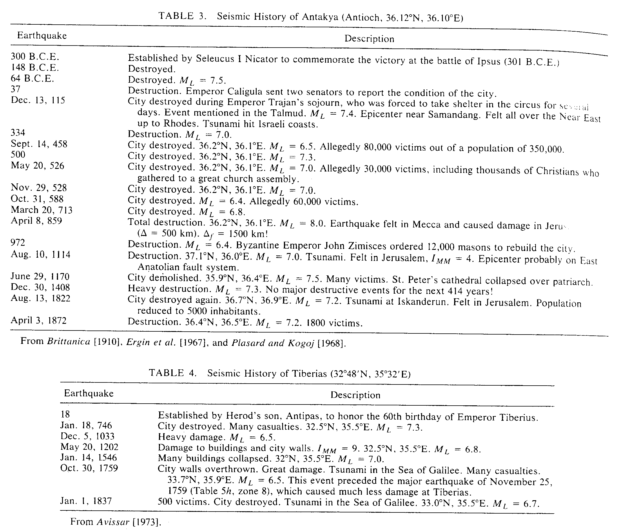
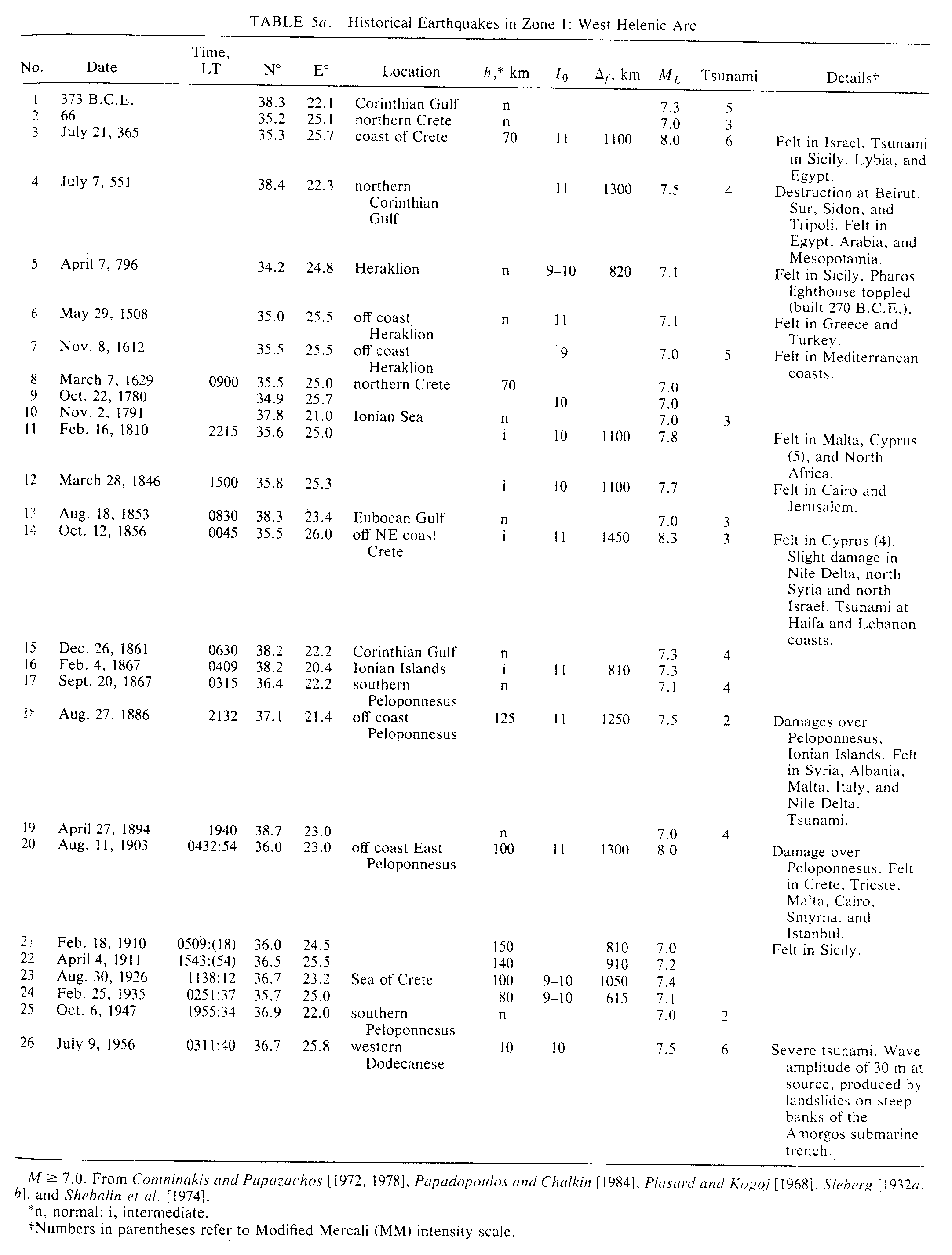
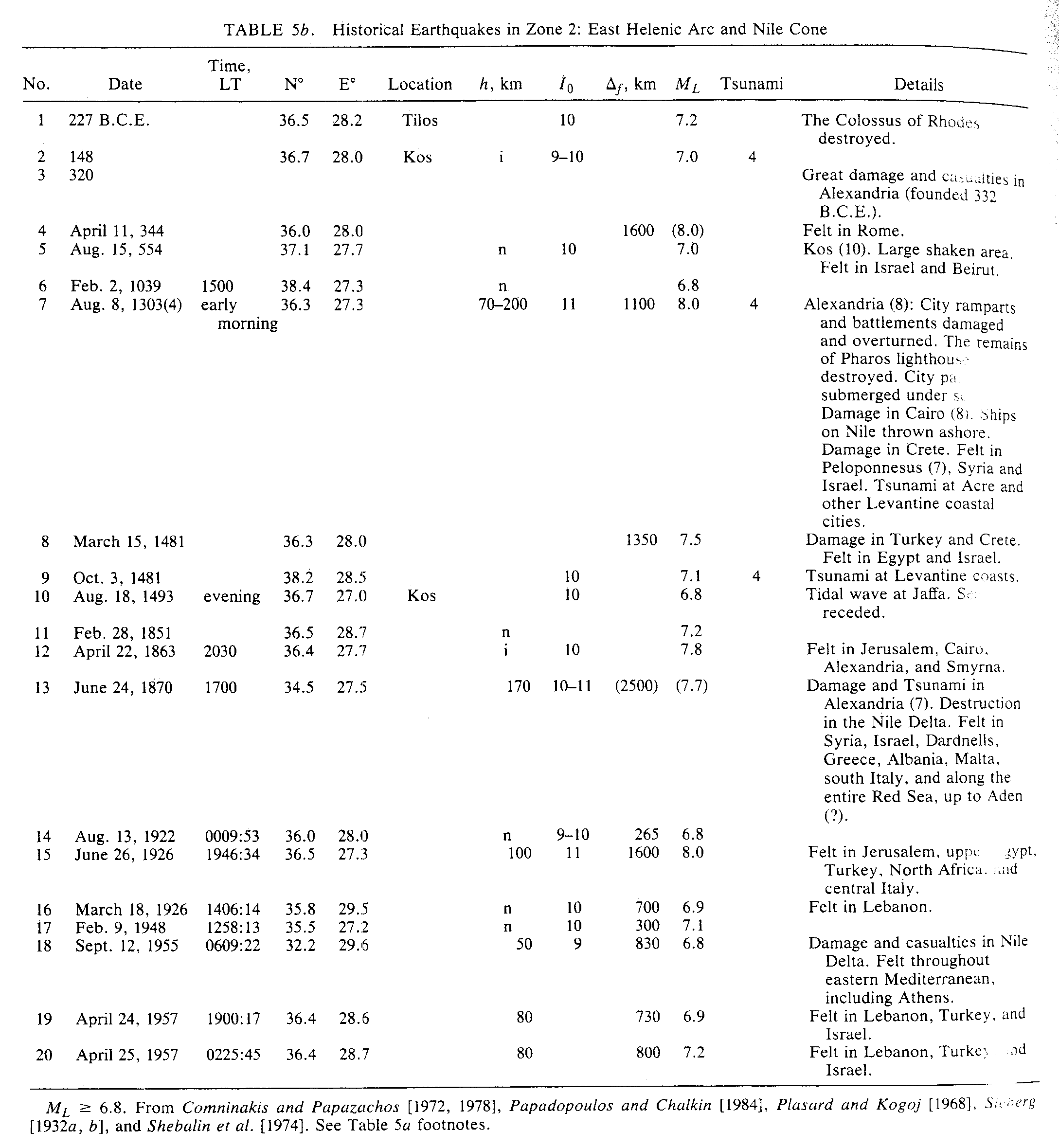
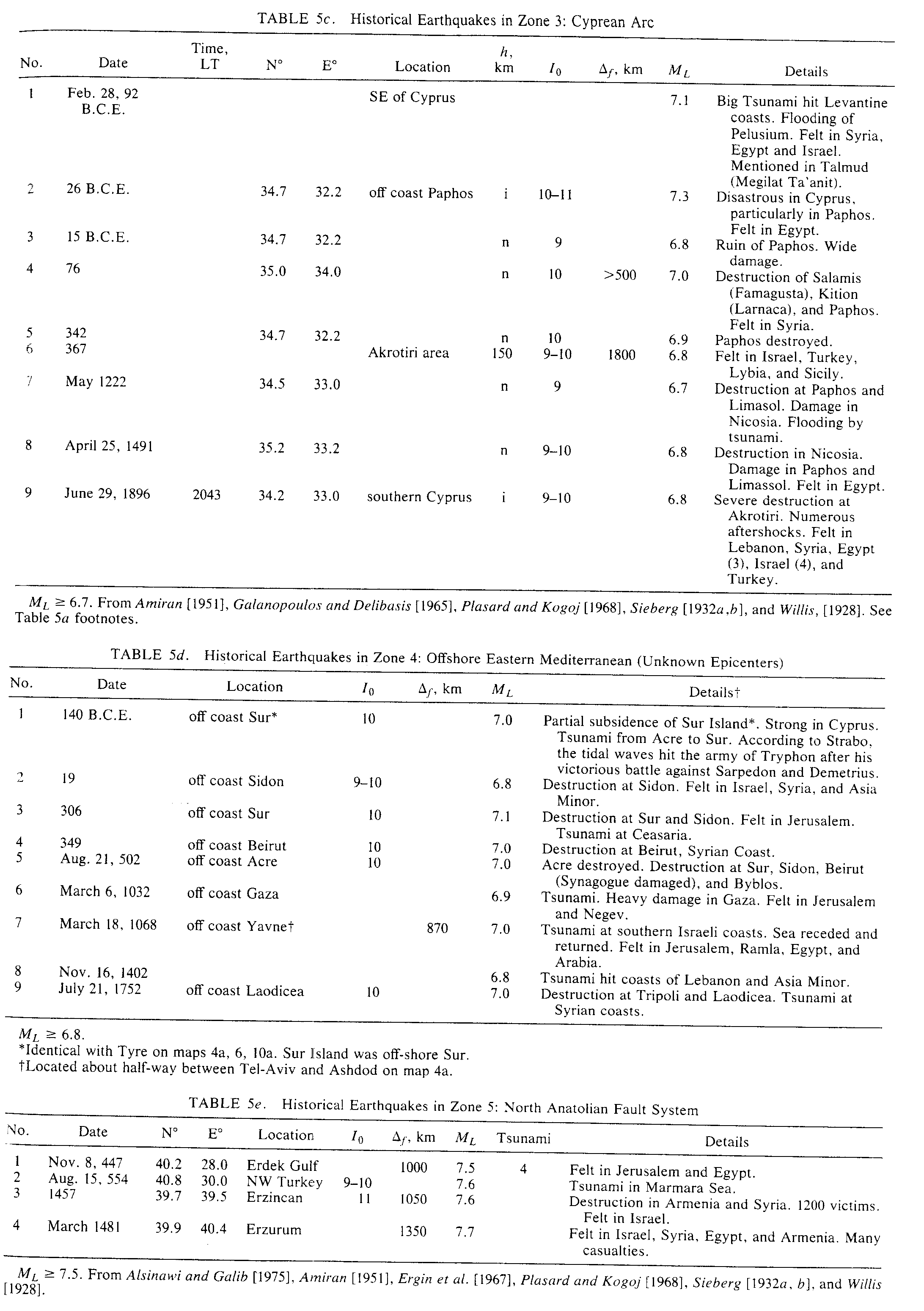
Ben-Menahem (1991)


5. EARTHQUAKES DURING HISTORICAL BIBLICAL TIMES
Leaving aside the story of the creation and prehistorical legends and myths (thus excluding the first 11 chapters of Genesis), we concern ourselves here with the epoch that begins with the patriarch Abraham and ends with the edict of Cyrus (538 B.C.E.). The corresponding biblical text was recorded intermittently, over the millenium circa 1300-300 B.C.E. and canonized circa 200 B.C.E.
In light of information gleaned from archaeological sources during the present century, scholars contend that the patriarchal narratives, as presented in the book of Genesis, reflect the life of real people and fit the frame of life in the Middle Bronze age, anywhere between 2100 and 1500 B.C.E. In any event, the stories foretold in the book of Genesis were written down several centuries after the events they describe, and were rearranged and edited many times since.
Moreover, most historical and environmental events in it are not dated. The Bible lacks a uniform time scale relative to a common reference point. Instead, events are given relative to local floating fiducials with unknown time spans among the various floaters. In this sense, we can say that the Bible is embedded in "amorphous time".
Nevertheless, the statistical laws of earthquake occurrence which we have discovered for the Near East tell us that catastrophic seismic events must have occurred in the lands of the Bible during the time window" circa 2100-300 B.C.E., and their occurrence must somehow echo in the Biblical narrative.
And indeed, the Bible affords us accounts and allusions concerning major earthquakes. Often, the reference is so terse that it passes unnoticed. The message that the Biblical editors have put across is transparent: the significance of the Bible lays not in the bare facts of history, but rather in its interpretation of history as a medium of revelation.
The Bible relates to earthquakes in four different categories:
5.1. Category .1: Traditional Seismicity of Specific Regions
Quotations which describe the seismicity of the six main provinces of the rift zone are: Sinai, I Kings 19: 11-12; Num. 16: 32-34; Exod. 19: 18-19; Judg. 5: 4; Ps. 68: 8-9; Arava, Ps. 29: 8; Judea and Jordan Valley, Josh. 3: 13-17; 4: 18-19; 6: 20; II Chron. 20: 2; Ps. 114: 5; I Sam. 14: 15; Galilee, I Kings 19: 11- 12; 20: 30; Lebanon, Ps. 29: 4-5; and Mediterranean Coast, Ezek. 26: 20-21; 27: 26-36.
5.2. Category 2: Attribution to God's Wrath
The prpohets, being very close to nature, were very keen and observant of environmental changes and singular geophysical events such as eclipses, earthquakes, landslides, droughts, floods, storms, meteorite showers, etc. These events were considered by them as punitive acts of God. Some references are II Sam. 22: 8; Isa. 5: 25; 13: 13; 15: 5; 24: 18-19; 29: 6; Jer. 4: 24; 10: 10; 48: 34; 49: 21; 51: 29; Ezek. 38: 19-20; Ps. 18: 8; 29: 6; 46: 3-7; 60: 4; 68: 9; 94: 4; 114: 4; Joel 2: 10; 3: 3-4; 4: 15-16; Nah. 1: 5; Hag. 20: 21; and Hab. 3: 6.
5.3. Category 3: Earthquake Effects in Jerusalem
Although severely shaken from time to time, Jerusalem never experienced earthquake intensity greater than modified Mercator (MM) 8. The reason is tha is located at a distance of some 40 km from the Dead Sea fault. Then, according to equations (A3) and , earthquakes of magnitude less or equal to 7 give rise at most to MM 8. In the case of two catastrophic events in 759 and circa 2100 B.C.E., Jerusalem was at a distance of at least 60 km from the fault's tip. The corresponding intensity in these cases, again, did not exceed MM 8. The following Biblical references describe this state of affairs quite accurately: Isa. 33: 20; Jer. 17: 25; Joel 4: 20; and Ps. 125: 1.
5.4. Category .4: Description of Specific Events
These specific events echo catastrophic seismic events of maximal magnitude. Although the biblical narrative is brief and succinct, it leaves no doubt as to the significance and intensity of the event. The time of occurrence and epicenter location are vague and must be corroborated from independent sources.
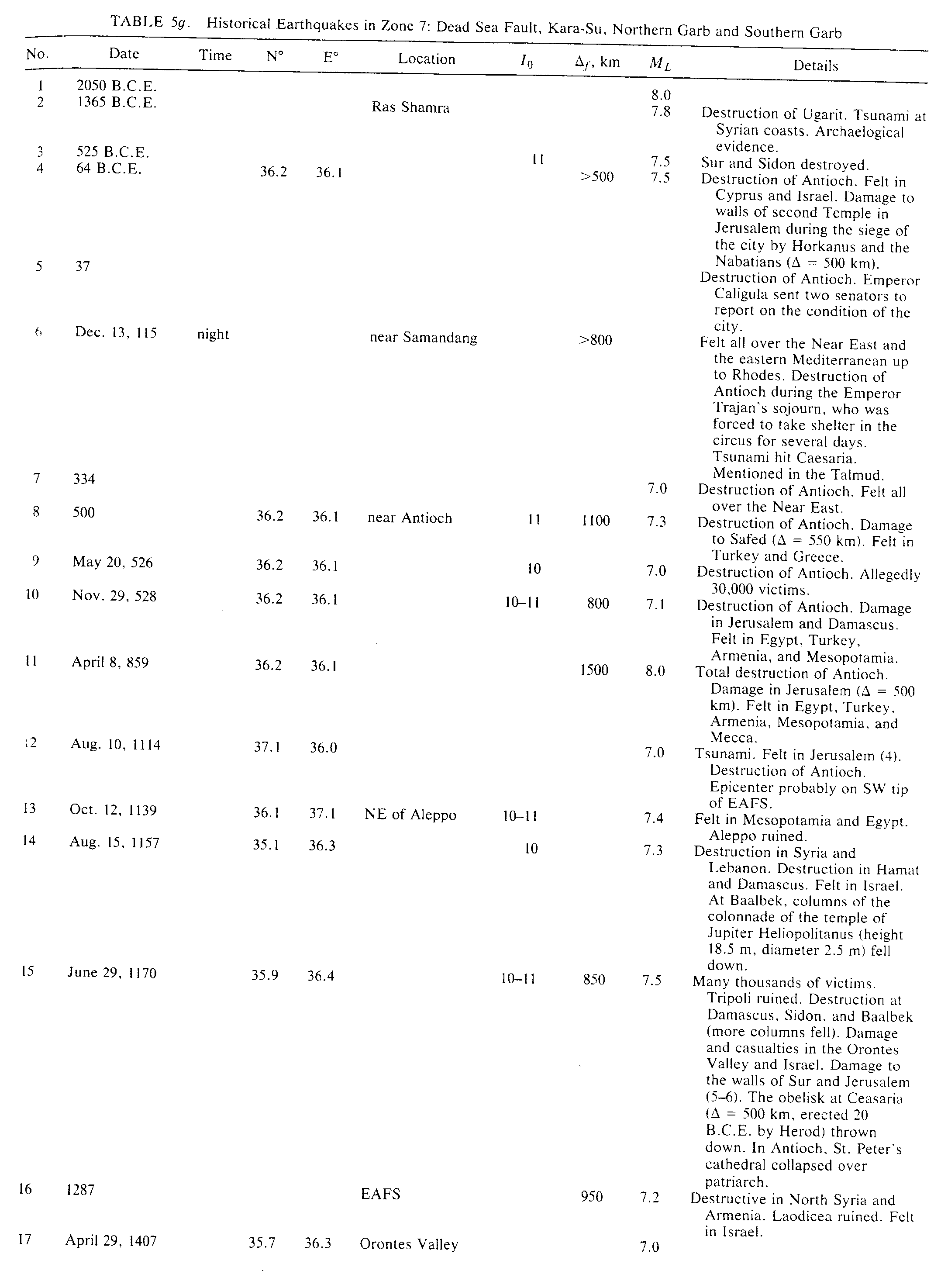
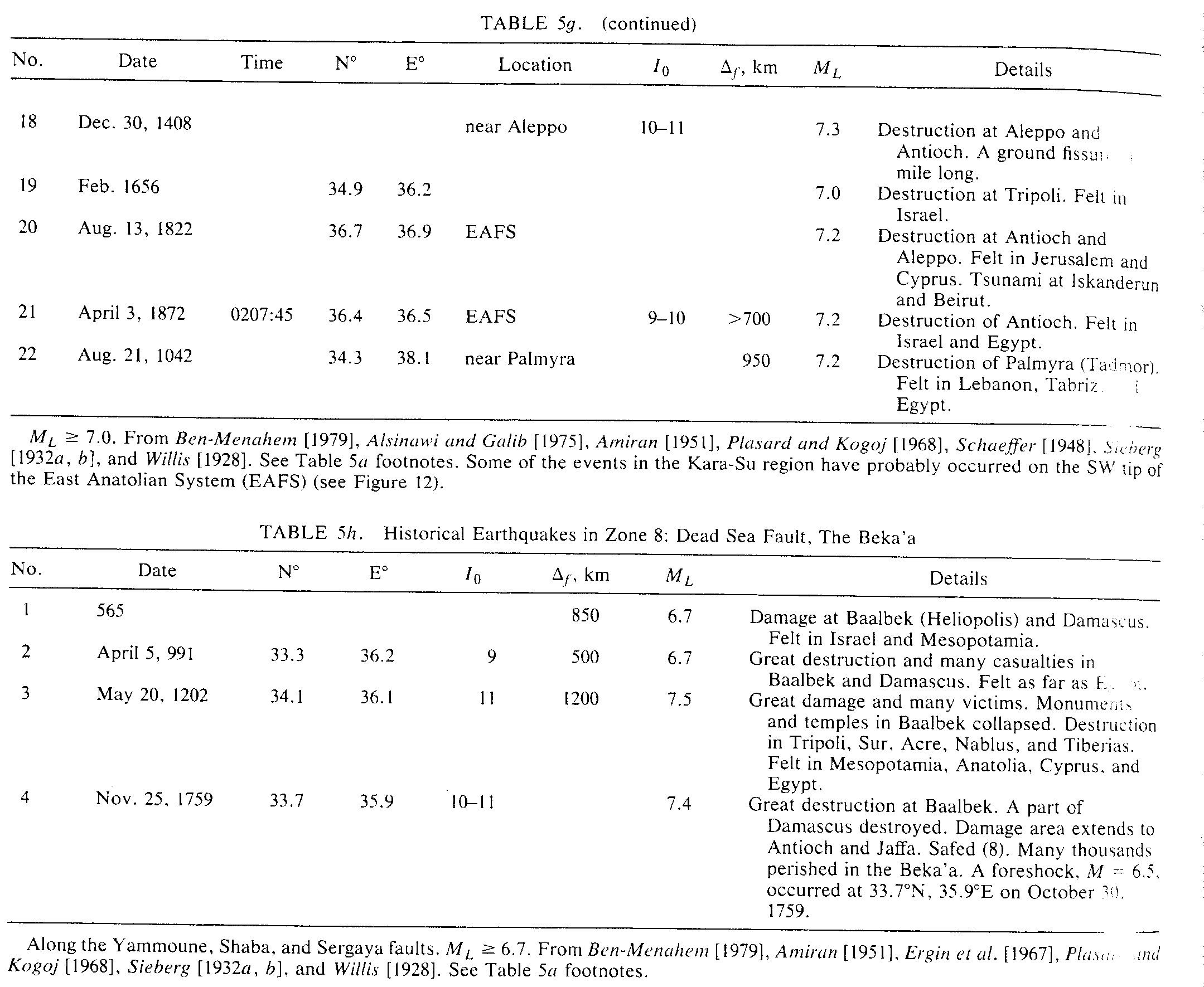
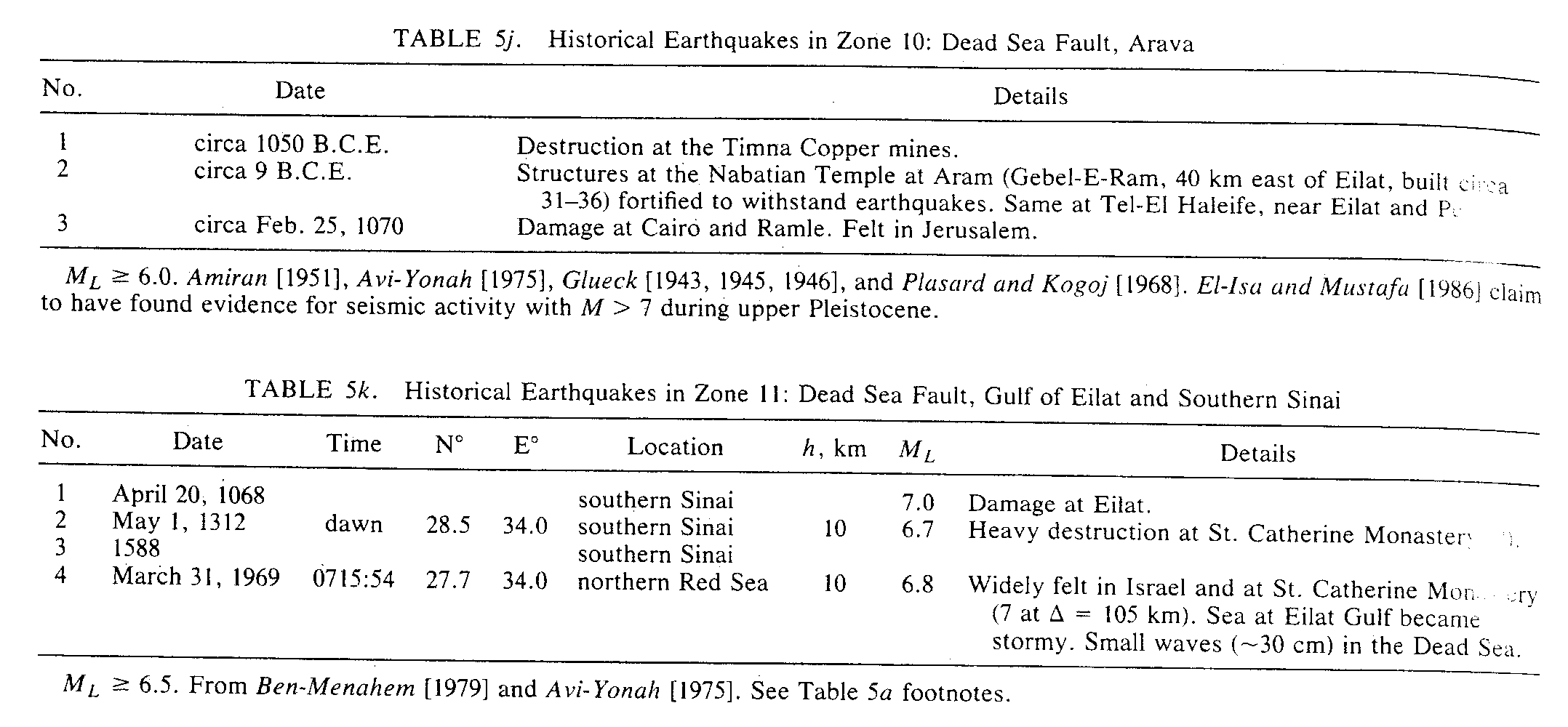
In Tables 1 and 5, we summarize our findings of three such events, the evidence for which can be found in the scriptures.
Two chapters in Genesis are built around the catastrophe that befell the five confederate cities of the plain: Sodom, Gomorrah, Admah, Zeboim, and Zoar. The overthrow of Sodom and Gomorrah echoes repeatedly throughout the Bible (Dent. 29: 22; Isa. 1; 9-10; Jer. 23: 14; 49: 18; 50: 40; Amos 4: 11; Ezek. 16: 46- 55; Zeph. 2: 9) and its memory kept reverberating throughout a period of 12 centuries.
5.4.1. Circa 2100 B.C.E.
The destruction of Sodom and Gomorah. The sole reference to this event is in Gen. 13-19. Tristram [1864, 1874], Smith [1863] and recently Nissenbaum [1990] forwarded arguments that the Biblical narrative seems to state positively that the cities of the plain lay on the northern end of the Dead Sea. On the other hand, the long continued tradition (Josephus, Hieronymus) and the names of existing sites seem to pronounce almost with equal positiveness that it was at the southern end. There are, however, two new discoveries which suggest that these cities were situated near the Lisan peninsula (Figure 4b), possibly on today's east coast of the Dead Sea. First, Albight [1924] and Albright et al. [1944] found at Bab-a-Da a, east of the Lisan Peninsula (Figure 1), the remnants of several large settlements from the period 2350-2100 B.C.E. They concluded that Zoar at the time of Abraham and Lot was at Bab-a-Dara'a (see also Isa. 15: 5).
On the other hand, studies of the seismicity of the Dead Sea area have disclosed [(Ben-Menahem, 1981; Ben- Menahem and Aboodi, 1981] that both historical and contemporary seismicity of the east side of the Dead Sea exceeds by far that of its west side. In fact, since 1837, all earthquakes near the Dead Sea with MI > 5 occurred near Bab-a-Dara'a, and most microearthquakes since 1975 took place along the east coast of the Dead Sea.
Thus, in his travelogues, Tristram [1874] gives a vivid account of earthquake ruins in the Castle of Rabba (31.34° N, 35.75° E; the Biblical Ashtarot, Karn'aim, Gen 14, 5), Dhiban (31.300 N, 35.60° E. Here King Mesha's monolith fell to the ground due to the earthquake of May 23, 1834, which led to its discovery in 1868), Um-Resas (31.53° N, 35.74° E) and Medeba (Figures 4a and 9). To the south, Khirbet Tanur [Glueck, 1943; 1945; 1946] was built in the first century B.C.E. and ruined by an earthquake in the second century (Figure 4). Recently, El-Isa and Mustafa [1986 ], following new methods of Seilacher [1984], furnished further evidence in favor of our hypothesis.
The time of occurrence of the Sodom and Gommorah earthquake can be estimated as 2100 B.C.E. if we accept the archaeological dating of the Patriarchs [Kenyon, 1978].
If the return period for maximal magnitude earthquakes is stable, the violent overthrow of the cities of the plain could have occurred indeed at about 2100 B.C.E. How can this be reconciled with the Biblical story? Kenyon [1978] suggested that the tenth century Biblical editor tried to coalesce into one story the various accounts that were current amongst the tribes and groups which had by then become combinedinto the people of Israel. These stories were "propagated" by word of mouth through some 50 generations before they were put in writing.
Schaeffer [1948] claimed to having found evidence for two seismic events which played a major role in the cultural history of the Near East. One is circa 1360 B.C.E. (recent Bronze 2), which caused the destruction of the city-state of Ugarit (Figures 5, 6, and 10b) and other cities in Asia Minor, Syria, and Canaan, within radius of 1000 km from Ugarit. The other was in circa 2100 B.C.E., having similar effects with the boundaries of approximately at the same radius. The 1365 event is not mentioned in the Bible, since it occurred while the Hebrews stayed in Egypt. The earthquake of 2100 may have been telescoped on the venerated patriarch.
Evidence for earthquakes earlier than 2100 B.C.E. comes from the archeological excavations in Jericho [Kenyon, 1957; 1978]. Although no specific date is given, one fact stands out: Between 2100 B.C.E. and 3100 B.C.E., the walls of the city were destroyed about 17 times. Let us give equal chance to destruction by erosion, floods, earthquakes, and war and assume also that a magnitude of at least 6.4 is needed to topple ancient wall fortifications within a distance of say 50 km. from the city. We then come up with about four ch events in 1000 years. This result is in accord with our frequency-magnitude relation log10 N = 3.1 0.86ML . In Figure 4 we have marked two other locations where archeological excavations have pointed to the possibility of destruction by earthquakes: at Tleilat el-A'sul, 3300- 3600 B.C.E., and Ai, 2700 B.C.E. [Avi-Yonah, 1975].
5.4.2. Circa 1560 B.C.E. 32° N, 35.5' E.
Destruction of Jericho and other cities. Recent archaeological excavations at Tel-Dir-Ala (32° 14'N, 35° 35'E) have shown [Avi-Yonah, 1975] that the city was destroyed by an earthquake close to that time. This location is identified with the biblical Succoth (Gen. 33: 17; Josh. 13: 27; Judg. 8: 5; I Kings 7: 46). Since the destruction of Jericho is dated at about the same time [Kenyon, 1978], it is likely that the two cities, some 45 km apart, were destroyed by the same earthquake. When Joshua took Jericho at about 1230 B.C.E., the tradition of the destruction of the city by the 1560 B.C.E. earthquake was still dominant in the Land of Israel. When these stories were put in writing by the scribes of the Kings of Judea (7-th century B.C.E.), the 1560 earthquake was "telescoped" on the epic of the conquest of Jericho. The cut-off of the waters of the Jordan River at Damye (the biblical city of Adam) by landslides of Lisan marl is obviously the basis of the biblical story in Josh. 3: 13-17 and 4: 18-19. Archaeological references are given in Avi-Yona [1975].
5.4.3. 759 B.C.E.
Felt throughout Israel, Egypt and Mesopotamia, Af 1200 km. According to the Bible, Josephus, the Talmudic literature and the late archeological findings at Hazor and Sebastia, the epicen seems to be east of Hazor, approximately at 33.0° 35.5° E. Year of occurrence is likely to be 759 B.C.E., in which King Uziah abdicated the throne in favor of his son Yotam [Cassuto, 1976; Josephus; II Chr. 26]. The date of this earthquake is linked to the eclipse of the Sun on June 15, 763 B.C.E. (Julian Day 1,442,902.8392, or Monday, Sivan 30, 2998, of the Jewish Calendar [see Kudlek and Mickler, 1971; Chambers, 1904, Thompson, 1900; Oppolzer, 1887; Fotheringham, 1920]). The eclipse was partial in Jerusalem (maximal magnitude 0.91). Evidence for the proximity of the earthquake and the eclipse is found in Amos 8: 8-9; Zech. 14: 4-7, and Jer. 4: 24.
The location of the causative fault can be estimated from the oriented tilt of the walls in stratum 6 at Hazor (Figure 6), a detail of which is shown in Figure 7. According to the report of the excavating archeologists [Yadin et al., 1959], northern walls were tilted southward, while western walls tilted eastward. Figure 8 shows that these orientations are consistent with the effect of a near field horizontal shear acceleration coming to Hazor from the north east. This is consistent with modern ideas that structures in the near-field of a major earthquake are mostly affected by SH body waves and the fundamental Love mode.
Day of occurrence, according to II Chron. and Josephus, is likely to be on the eve of the Tabernacle holiday, 14 Tishrei, 3003, which is October 759 B.C.E. There was great destruction in Judea, Sal,aria, and Galilee. Intensity at Jerusalem (A = 135 km) estimated as MM 8; 1 = 11; big earth slips in the Kidron Valley, destruction of Razor, Sebastia (Mic. 1: 6) and the ancient city of Kinnereth (9 km north of Tiberias). A tsunami in the Sea of Galilee is hinted in Amos 5: S; 9: 5-6.
References are Amos 1: 1; 3: 14-15; 4: 11; 5: 8; 6: 11; 8: 8-10; 9: 1; Zech. 14: 4-5; Jer. 4: 24; 1: 3-6; Nah. 1: 4-5; II Kings 12: 6; 23: 22; II Chr, 26; Josephus [9: 14]; Avi-Yonah [1975]; Yadin et al., :359
Albright, W.F., The archaeological results of an expedition to Moab and Dead Sea, Bull. Am. Sch. Orient. Res., 7, 2-12, 1924.
Albright, W.F., J.L. Kelso, and T.J. Palin, Early Bronze Pottery from Bab-ed-dra in Moab, Bull. Am. Sch. Orient. Res., 27, 3-13, 1944.
Alsinawi, S., and H.A.A. Galib, Historical seismicity of Iraq, Bull. Seism. Soc. Am. 65, 541-547, 1975.
Amiran, D., A revised earthquake catalogue of Palestine, Isr. Expl. J., 4, 223-246, 1951.
Armijo, R., A. Deschamps, and J.-P. Poirier, Carta sismotectonique de PEurope et du Bassin Mediterranean, Inst. de Phys. du Globe, Paris, 1985.
Avissar, 0., History of Tiberias (in Hebrew), 480 pp., Keter, Jerusalem, 1973.
Avi-Yonah, M. (Ed.), Encyclopedia of Archaelogical Excavations in the Holy Land, Massada, London, 1975.
Ben-Menahem, A., Dating of historical earthquakes by mud profiles of lake-bottom sediments, Nature, 262, 200-202, 1976.
Ben-Menahem, A., Earthquake catalogue for the Middle East (92 BC-1980 AD), Boll. Geofis. Teor. Appl., 21, 245-310, 1979.
Ben-Menahem, A., Variation of slip and creep along the Levant Rift over the past 4500 years, Tectonophys., 80, 183-197, 1981.
Ben-Menahem, A., Peak accelerations from subshear and supershear radiation of kinematic dislocation models, J. Phys. Earth, 34, 297-334, 1986.
Ben-Menahem, A., and E. Aboodi, Tectonic patterns in the northern Red-Sea region, J. Geophys. Res., 76, 2674- 2689, 1971.
Ben-Menahem, A., and E. Aboodi, Micro- and macroseismicity of the Dead-Sea Rift and off-coast Eastern Mediterranean, Tectonophys., 80, 199-233, 1981.
Ben-Menahem, A., and D. Brooke, Earthquake risk in the Holy Land, Boll. Geofis. Teor. Appl., 24, 175-203, 1982.
Ben-Menahem, A., M. Vered, and A. Nur, Tectonics, seismicity and structure of the Afro-Eurasian junction, Phys. Earth Planet. Inter. 12, 1-50, 1976.
Ben-Menahem, A., E. Aboodi, M. Vered, and R.L. Kovach, Rate of seismicity of the Dead-Sea region over the past 4000 years, Phys. Earth Planet. Inter. 14, 17-27, 1977.
Bloch, M.R., Dead Sea whiteness and its origin, Proc. Isr. Acad. Sci. Humanit., Sect. Sci., 19, 1-7, 1980. Brittanica, The Encyclopeadia, 11th ed., Cambridge, University Press, New York, 1910.
Cassuto, U.M.D. (Ed.), Encyclopedia Biblica, The Bialik Institute, Jerusalem, 1976.
Chambers, G.F., The Story of Eclipses, McClure, Phillips, New York, 1904.
Cornninakis, P.E., and B.C. Papazachos, Seismicity of the eastern Mediterranean and some tectonic features of the Mediterranean ridge, Geol. Soc. Am. Bull., 83, 1093- 1102, 1972.
Comninakis, P.E., and B.C. Papazachos, A catalogue of earthquakes in the Mediterranean and the surrounding area for the period 1901-1975, Geophys. Lab. Publ., 5, 96 pp, Univ. of Thessaloniki, 1978.
El-Isa, Z.H., and H. Mustafa, Earthquakes deformation in the Lissan deposits and seismotectonic implications, Geophys. J.R. Astron. Soc., 86, 413-424, 1986.
Ergin, K., U. Guclu, and Z. Uz, A Catalog of Earthquakes for Turkey and Surrounding Area (11 AD - 1964 AD), Technical University of Istanbul, 1967.
Flemming, N.C., Archeaological evidence of tectonic activity in the region of the Haifa-Qishon Graben, Israel, Tectonophysics, 52, 177-178, 1979.
Fotheringham, J.K., A solution of ancient eclipses of the Sun, Mon. Not. R. Astron. Soc., 81, 104-126, 1920.
Freund, R., A model of the structural development of Israel and adjacent areas since Upper Cretaceous times, Geol. Mag., 102, 189-205, 1965.
Galanopoulos, A.G., and N.D. Delibasis, The seismic activity of the Cyprus area 26 BC - 1963 AD, Proc. Athens Acad., 43, 387-405, 1965.
Glueck, N., Some ancient towers in the plains of Moab, Bull. Am. Sch. Orient. Res., 26, 71-83, 1943.
Glueck, N., The Other Side of the Jordan, 181 pp., Bialik Institute, Jerusalem, 1945.
Glueck, N., The River Jordan, in Hebrew, 123 pp., The Bialik Institute, Jerusalem, 1946.
Josephus, The Jewish Wars, 37-95 AD, Penguin, New York, 1959.
Kenyon, K.M., Digging Up Jericho, Ernest Benn, London, 1957.
Kenyon, K.M., The Bible and Recent Archaeology, British Museum Publications, London, 1978.
Kenyon, K.M., Archaeology in the Holy Land, 4th ed., 360 pp., Ernest Benn, London, 1979.
Kudlek, M., and E.H. Mickler, Solar and Lunar Eclipses of the Ancient Near East from 3000 B.C. to 0 With Maps, Butzon and Bercker Kevelaer, Berlin, Germany, 1971.
Neev, D., and K.O. Emery, The Dead Sea, Bull. Geol. Surv. Isr., 41, 147pp., 1967.
Neev, D., Recent faulting along the Mediterranean Coast of Israel, Nature, 245, 254-256, 1973.
Nissenbaum, A., Sodom, Gomorrah and the lost cities of the plain, (abstract), Proc. Inter. Conf. Math. Geophys. 18th, Jerusalem, Israel, p. 76, 1990.
Oppolzer, T.R., Cannon Der Finsternisse, Denkschriften der Kaiserlichen Akademie der Wissenschafter, Wien, 1887.
Papadopoulos, G.A., and B.J. Chalkis, Tsunamis observed in Greece and the surrounding area from antiquity to the present times, Mar. Geol., 56, 309-317, 1984.
Plasard, J., and B. Kogoj, Catalogue des Seisms Ressentis au Liban, Annals Memoirs, 28pp., Ksara, Obs. Ksara, Lebanon, 1968.
Poirier, J.P., and M.A. Taher, Historical seismicity in the Near and Middle East, North Africa and Spain from Arabic documents (7th-8th Century), Bull. Seismol. Soc. Am., 70, 2185-2201, 1980.
Schaeffer, C.F.A., Stratigraphic Compares et Chronologie de l'Asie Occidental; 653 pp., Oxford University Press, New York, 1948.
Seilacher, A., Sedimentary structures tentatively attributed to seismic events, Mar. Geol., 55, 1-12, 1984.
Shebalin, N.V., V. Karnik, and D. Hadzievski, Survey of the seismicity of the Balkan region, in Catalogue of Earthquakes, 2100 BC-1870 AD, UNESCO, Skopje, Yugoslavia, 1974.
Sieberg, A., Erdbebengeographie, in Handbucl physik, band IV, edited by B. Gutenberg, pp. Borntrager, Berlin, 1932a.
Sieberg, A., Untersuchungen fiber Erdbeben and schollenbau im Ostlichen Mittelmeergebiet, Med. wiss. Ges., 18, 159-273, 1932b.
Smith, W., A Dictionary of the Bible in Three Volum es, edited by J. Murray, publisher, London, 1863.
Thompson, R.C., The Reports of the Magicians and Astrologers of Nineveh and Babylon in the British Museum, I-II, Luzac, London, 1900.
Tristram, H.B., The Land of Israel: A Journal of Palestine, 633 pp., London Society for Promot tian Knowledge, 1864.
Tristram, H.B., The Land of Moab: Travels and Discoveries on the East Side of the Dead Sea and the Jordan, edited by J. Murray, publishers, 416 pp., London, 1874.
Vered, M., and L. Striem, A macroscopic study of the implications of structural damage of two recent major earthquakes in the Jordan rift, Bull. Seismol. Soc. Am., 67, 1607-1613, 1977.
Whitehouse, D., and R. Whitehouse, Archaeologic-Atlas of the World, Freeman, Cooper, San Francisco, C. 1975.
Willis, B., Earthquakes in the Holy Land, Bull. Soc. Am., 18, 73-103, 1928.
Yadin, Y., Y. Aharoni, I. Dunayevsky, T. Dothan, R. Amiran, and J. Perrot, Excavations at Hazor. The Second Campaign, Aug. 1, 1956-Nov. 1, 1956 (in Hebrew), Mosad Bialik and the Israel Exploration Society, Jerusalem, 1959.
Ben-Menahem, A. (1991). "Four Thousand Years of Seismicity along the Dead Sea rift." Journal of Geophysical Research 96((no. B12), 20): 195-120, 216.