Tel Tanninim
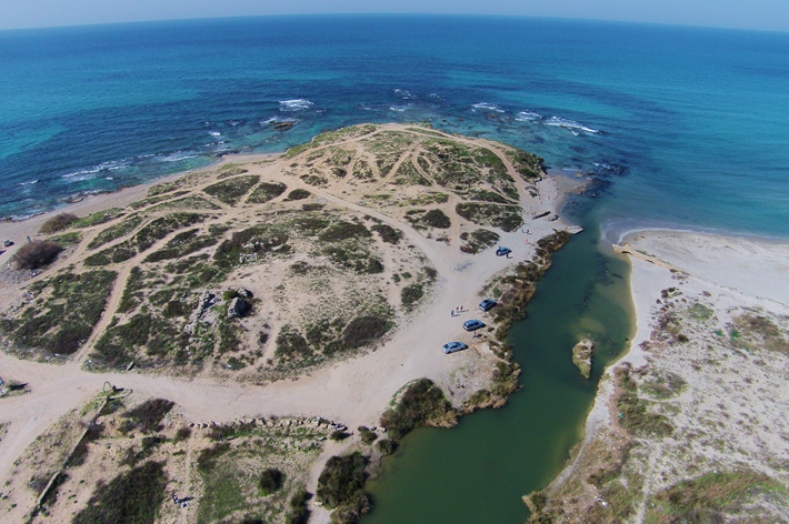
 Aerial View of Tel Tanninim
click on image to open a high res magnifiable image in a new tab
Used with permission from BibleWalks.com
| Transliterated Name | Source | Name |
|---|---|---|
| Tel Tanninim | Hebrew | תל תנינים |
| Tell al-Milāt | Arabic | |
| Burj al-Malih | Arabic | |
| Migdal Malhā | Aramaic | |
| Krokodeilon polis | Greek | |
| Crocodeilopolis, Crocodilopolis | Greek | |
| Turris Salinarum | Latin - Crusader |
- from Stieglitz (2000)
- from Stieglitz (2000)
The finds in Area A include remains of several structures from the Crusader, Islamic and Late Byzantine periods, which were built atop the foundation walls of a large Early Byzantine church, whose floors were covered with multi-colored mosaics, poorly preserved. Below the Early Byzantine level was a gap, marked by a thick layer of sterile sand, and below that a thick layer with structural and ceramic and other remains of the Persian-Hellenistic settlement.
In Areas B and B2 were found fishponds (Latin: piscina) for breeding of freshwater fish and in Area D and the western coastline were several ponds for saltwater fish. The freshwater ponds were supplied with running water by the Tel Tanninim Aqueduct, which tapped into the high-level aqueduct of Caesarea, had thick plastered walls and utilized a system of embedded ceramic jars either within the walls or along the floor to create a series of cells (Latin: speci) for the freshwater fish, such as the tilapia (St. Peter's fish) bred and grown in the ponds. Each breeding pond had a small tank with a mosaic floor built nearby, presumably for holding and sorting fish. The aqueduct and breeding ponds were evidently built in the fourth century CE and continued to operate through the end of the Seventh century.
Sometimes in the Sixth century CE, the water flow in the aqueduct of Tel Tanninim was disrupted, but the freshwater fishing industry at the site continued to operate with well water. The water was drawn from a round well-built stone well, three meters in diameter, dug into the aquifer adjacent to the breeding pond in Area B2. Across the well's center a wooden wheel had been installed, around whose perimeter were attached a series of ceramic jars, fragments of which were found. In Talmudic sources, this type of pump is called an 'antelayyā-wheel.
- from Taninim Creek Dam Paleoseismic Site Webpage - click link to open new tab
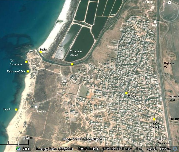
- Annotated Satellite Photo
of Tel Taninnim and environs from BibleWalks.com
- Aerial Drone shot of Tel Tanninim
from BibleWalks.com

 Aerial Drone shot of Tel Tanninim
Click on image to open a high res magnifiable image in a new tab
Used with permission from BibleWalks.com - Aqueducts of Caesarea
from Stern et al (2008)

 Aqueducts of Caesarea
Stern et al (2008) - Tel Tanninim in Google Earth
- Tel Tanninim on govmap.gov.il
- Aqueducts of Caesarea
from Stern et al (2008)

 Aqueducts of Caesarea
Stern et al (2008)
- Illustration of Tel Tanninim
in the Byzantine period from Stieglitz (2000)

 Illustration of Tel Tanninim in the Byzantine period
By John Maceal
Stieglitz (2000)
- from da Costa (2008)'s review of Stieglitz et al (2006)
- from main excavation areas A and A2
| Phase | Period | Dates |
|---|---|---|
| IX | Iron Age | |
| VIII | Persian | 450-332 BCE |
| VII | Hellenistic | 332-ca. 100 BCE |
| GAP | ca. 100 BCE - 324 CE | |
| VI | Early Byzantine | 324-450 CE |
| V | Late Byzantine | 450-600 CE |
| IV | Final Byzantine to Umayyad | 600-750 CE |
| III | Abbasid to Fatimid | 750-1099 CE |
| IIB | Crusader | 1099-1265 CE |
| IIA | Mamluk | 1265-1400 CE |
| I | Mamluk to Late Ottoman | 1400-1917 CE |
- from Stieglitz (2000)
 The stratigraphic table summarizes the occupation history of Tel Tanninim
Stieglitz (2000)
da Costa (2008:96-97) in her review of Stieglitz et al (2006) suggests that the Stratum IV destruction layer may have been due to one of the 749 CE Sabbatical Year Earthquakes (the Holy Desert Quake).
There are some substantial difficulties with this publication which detract from its value. The greatest problem is the discrepancy in dating the final destruction of the church, and thus the end of the main period of occupation at the site. The stratigraphic report clearly states that the burnt destruction layer belongs to the mid-eighth century (p. 37 — with some confusion about the meaning of a tenth-century rim in the destruction level). The pottery and glass reports, which are difficult to check, appear to have substantial amounts of material that date from the sixth to eighth centuries, although Oren-Paskal simply ignores this and concludes that "a common sixth—seventh century date has emerged" and the assemblage "is homogeneous in terms of its date" (p. 148). In his overall conclusions, Stieglitz claimed that "in the seventh century, the settlement (Stratum IV) began to experience a rapid decline . . ." and "By the end of the seventh and the beginning of the eighth century, the large basilica church . . . had fallen into disuse. The fish farms . . were certainly abandoned" (p. 227). Yet this is the phase at the church when all the floors, including mosaics, were again raised and an altar platform constructed. It was also the period when a substantial, fortified building was erected in Area A2; and the water reservoir in Area B2 was not thought to go out of use until the eighth century. Since substantial burning is associated with all destruction levels, perhaps the 749 earthquake may have been the cause, even if by then the settlement was much reduced in size.
We might also query the characterization of the Abbasid to Fatimid period as a phase at the site. Even if the undoubted wall robbing that occurred could be dated to this period, should that constitute a phase, or should a second gap in occupation be recorded? The picture is complicated by claims in some sections that there was no Abbasid occupation, contrasting with the existence of some Abbasid pottery and at least one coin.
Costa, K. da. (2008). [Review of Tel Tanninim: Excavations at Krokodeilon Polis, 1996-1999, by R. R. Stieglitz].
Bulletin of the American Schools of Oriental Research, 351, 94–97.
Porat Y, (2002) The water-supply to Caesarea: a re-assessment, in Amit D, Patrich J, and Hirschfeld Y, (eds)
The Aqueducts of Israel, Volume 46: Portsmouth, Rhode Island, Journal of Roman Archaeology,
Supplementary Series, pp 104–129
Taxel, I. (2013). "Rural Settlement Processes in Central Palestine, ca. 640–800 c.e.: The Ramla-Yavneh Region as a Case Study." Bulletin of the American Schools of Oriental Research 369: 157 - 199.


