Palmyra
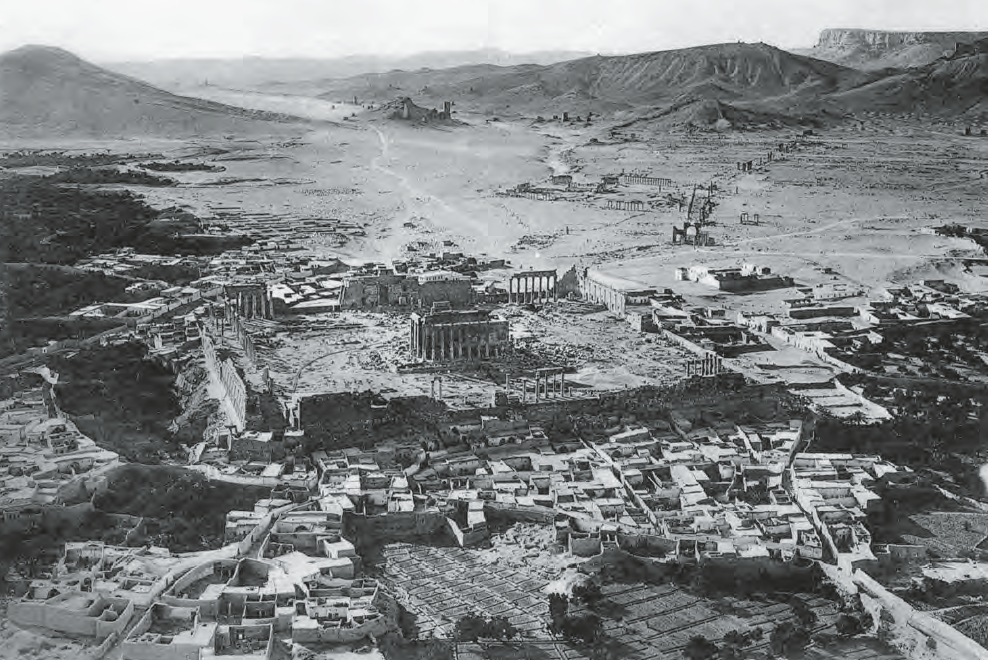 Figure 3
Aerial photograph of Palmyra taken looking southwest
(Poidebard 1934, pl. 67).
Intagliata (2018)
| Transliterated Name | Source | Name |
|---|---|---|
| Palmyra | Palmyrene | |
| Tadmor | Arabic | تَدْمُر |
| Tadmur | Arabic | تَدْمُر |
| dh-m-r | Western Semitic |
- Fig. 1 - Location Map from
Miranda and Raja (2022)
 Figure 1
Map of Palmyra and the surrounding region (courtesy of Eivind Seland, University of Bergen, Norway). Base map copyright ESRI.
Miranda and Raja (2022)
- Palmyra in Google Earth
 Palmyra in Google Earth
click on image to explore this site on a new tab in Google Earth - Fig. 3.2 - Aerial view of Palmyra
from the 1920s from Andrade and Raja (2022)
 Figure 3.2
. Aerial view of Palmyra from the 1920s.
© Rubina Raja and Palmyra Portrait Project,
courtesy of Mary Ebba Underdown.
Andrade and Raja (2022) - Fig. 3.1 - View of Palmyra
from Andrade and Raja (2022)
 Figure 3.1
View of Palmyra with the oasis in the background.
Courtesy of Jørgen Christian Meyer
Andrade and Raja (2022)
- Map 0.1 - Map of Palmyra
from Raja (2024)
 Map 0.1
City plan of Palmyra and its four necropoleis
Courtesy of Katarína Mokránová and Rubina Raja. Vector data were based on extended Topographia Palmyrena (Schnädelbach 2008) data, provided courtesy of Deutsches Archäologisches Institut (Orient-Abteilung, AS Damaskus).
Raja (2024) - Fig. 3.3 - Map of Palmyra and the
surrounding area from Andrade and Raja (2022)
 Figure 3.3
Map of Palmyra and the surrounding area.
Courtesy of Klaus Schnädelbach.
Andrade and Raja (2022) - Fig. 2 - Annotated and numbered
Intagliata (2018)

Figure 2
Plan of Palmyra
- Houses of Achilles and Cassiopea
- Sanctuary of Bēl
- Great Colonnade
- Suburban Market
- Byzantine Cemetery
- Buildings encroaching Section A of the Great Colonnade
- Church
- Baths of Diocletian
- Theatre
- Annexe of the Agora
- Agora
- Sanctuary of Arṣū
- Congregational Mosque
- Church
- Tetrapylon
- Sanctuary of Baalshamīn
- Umayyad Sūq
- Church II
- Church III
- Church IV
- House F
- Church I
- Bellerophon Hall
- Church
- Peristyle Building
- Transverse Colonnade
- Camp of Diocletian
- Sanctuary of Allāth
- Building [Q281]
- Efqa spring
- Western Acqueduct
(redrawn after Schnädelbach 2010).
Intagliata (2018) - Fig. 2 - Map of Palmyra from
Miranda and Raja (2022)
 Figure 2
Map of Palmyra (courtesy of Klaus Schnädelbach).
Miranda and Raja (2022) - Fig. 4 - Plan of Palmyra in 1931
from Intagliata (2018)
 Figure 4
The state of the ruins of Palmyra in 1931
Bureau Topographique des Troupes Françaises du Levant (detail; scale 1:10,000. Courtesy of the National Library of Scotland)
Intagliata (2018)
- Map 0.1 - Map of Palmyra
from Raja (2024)
Map 0.1
City plan of Palmyra and its four necropoleis
Courtesy of Katarína Mokránová and Rubina Raja. Vector data were based on extended Topographia Palmyrena (Schnädelbach 2008) data, provided courtesy of Deutsches Archäologisches Institut (Orient-Abteilung, AS Damaskus).
Raja (2024) - Fig. 3.3 - Map of Palmyra
and the surrounding area from Andrade and Raja (2022)
Figure 3.3
Map of Palmyra and the surrounding area.
Courtesy of Klaus Schnädelbach.
Andrade and Raja (2022) - Fig. 2 - Annotated and
numbered site plan from Intagliata (2018)
Figure 2
Plan of Palmyra
- Houses of Achilles and Cassiopea
- Sanctuary of Bēl
- Great Colonnade
- Suburban Market
- Byzantine Cemetery
- Buildings encroaching Section A of the Great Colonnade
- Church
- Baths of Diocletian
- Theatre
- Annexe of the Agora
- Agora
- Sanctuary of Arṣū
- Congregational Mosque
- Church
- Tetrapylon
- Sanctuary of Baalshamīn
- Umayyad Sūq
- Church II
- Church III
- Church IV
- House F
- Church I
- Bellerophon Hall
- Church
- Peristyle Building
- Transverse Colonnade
- Camp of Diocletian
- Sanctuary of Allāth
- Building [Q281]
- Efqa spring
- Western Acqueduct
(redrawn after Schnädelbach 2010).
Intagliata (2018) - Fig. 2 - Map of Palmyra
from Miranda and Raja (2022)
Figure 2
Map of Palmyra (courtesy of Klaus Schnädelbach).
Miranda and Raja (2022) - Fig. 4 - Plan of Palmyra
in 1931 from Intagliata (2018)
Figure 4
The state of the ruins of Palmyra in 1931
Bureau Topographique des Troupes Françaises du Levant (detail; scale 1:10,000. Courtesy of the National Library of Scotland)
Intagliata (2018)
- Fig. 4 - Map of Palmyra city
centre from Miranda and Raja (2022)
 Figure 4
Map of the city centre of Palmyra (courtesy of Michał Gawlikowski).
Miranda and Raja (2022)
- Fig. 4 - Map of Palmyra
city centre from Miranda and Raja (2022)
Figure 4
Map of the city centre of Palmyra (courtesy of Michał Gawlikowski).
Miranda and Raja (2022)
- Fig. 48 - Camp of
Diocletian from Intagliata (2018)
 Figure 48
Camp of Diocletian. Letters indicate barrack blocks
(Kowalski 1994, pl. 26)
Intagliata (2018) - Fig. 18 - Praetorium
in Camp of Diocletian from Intagliata (2018)
 Figure 18
Camp of Diocletian, Praetorium, final stage of occupation
(Kowalski 1994, pl. 28).
Intagliata (2018) - Fig. 52 - Plan of
the Sanctuary of Allath (Camp of Diocletian) from Intagliata (2018)
 Figure 52
Sanctuary of Allāth, Late Antique phase, Camp of Diocletian
(Kowalski 1994, pl. 27)
Intagliata (2018)
- Fig. 48 - Camp of
Diocletian from Intagliata (2018)
Figure 48
Camp of Diocletian. Letters indicate barrack blocks
(Kowalski 1994, pl. 26)
Intagliata (2018) - Fig. 18 - Praetorium
in Camp of Diocletian from Intagliata (2018)
Figure 18
Camp of Diocletian, Praetorium, final stage of occupation
(Kowalski 1994, pl. 28).
Intagliata (2018) - Fig. 52 - Plan of
the Sanctuary of Allath (Camp of Diocletian) from Intagliata (2018)
Figure 52
Sanctuary of Allāth, Late Antique phase, Camp of Diocletian
(Kowalski 1994, pl. 27)
Intagliata (2018)
- Fig. 23 - Plan of
House F in 2 phases from Intagliata (2018)
 Figure 23
House F. Roman (top) and post-Roman (bottom) phases
(Gawlikowski 1996, figs 1–2)
Intagliata (2018) - Fig. 1 - Original
(Roman) Plan of House F from Gawlikowski (1992a)
 Figure 1
The original phase of the house
Gawlikowski (1992a) - Fig. 2 - Final
Plan of House F from Gawlikowski (1992a)
 Figure 2
The final phase of the house
Gawlikowski (1992a)
- Fig. 23 - Plan of
House F in 2 phases from Intagliata (2018)
Figure 23
House F. Roman (top) and post-Roman (bottom) phases
(Gawlikowski 1996, figs 1–2)
Intagliata (2018) - Fig. 1 - Original
(Roman) Plan of House F from Gawlikowski (1992a)
Figure 1
The original phase of the house
Gawlikowski (1992a) - Fig. 2 - Final
Plan of House F from Gawlikowski (1992a)
Figure 2
The final phase of the house
Gawlikowski (1992a)
- Fig. 31 - Plan and
front of Church I from Intagliata (2018)
 Figure 31
Church I
(Gawlikowski 1990a, 41, fig. 2)
Intagliata (2018)
- Fig. 31 - Plan and
front of Church I from Intagliata (2018)
Figure 31
Church I
(Gawlikowski 1990a, 41, fig. 2)
Intagliata (2018)
- Fig. 19 - Sanctuary of
Baalshamīn from Intagliata (2018)
 Figure 19
Grande Cour and Bâtiment Nord, Sanctuary of Baalshamīn
(drawn by the author after plans at the Fonds d’Archives Paul Collart, Université de Lausanne).
Intagliata (2018)
- Fig. 19 - Sanctuary of
Baalshamīn from Intagliata (2018)
Figure 19
Grande Cour and Bâtiment Nord, Sanctuary of Baalshamīn
(drawn by the author after plans at the Fonds d’Archives Paul Collart, Université de Lausanne).
Intagliata (2018)
- Fig. 24 - Plan of
Peristyle Building from Intagliata (2018)
 Figure 24
Peristyle Building
(Grassi and al-Asʿad 2013, 125, fig. 5)
Intagliata (2018)
- Fig. 24 - Plan of
Peristyle Building from Intagliata (2018)
Figure 24
Peristyle Building
(Grassi and al-Asʿad 2013, 125, fig. 5)
Intagliata (2018)
- Fig. 7 - Al-Bakhra
Fort from Intagliata (2018)
 Figure 7
Al-Bakhrāʾ
(Genequand 2012, 75, fig. 46)
Intagliata (2018)
- Fig. 7 - Al-Bakhra
Fort from Intagliata (2018)
Figure 7
Al-Bakhrāʾ
(Genequand 2012, 75, fig. 46)
Intagliata (2018)
- Figure 3.4 Dropped Keystone
in main arch of the colonnade from Kázmér et al. (2024)
 Figure 3.4
Palmyra, The main arch of the colonnade. The dropped keystone indicates severe shaking parallel with the plane of the arch (in-plane deformation). ADB photo #4267. Taken on 26 September 2008 (before the arch was destroyed in 2015)
Kázmér et al. (2024) - Figure 3.5 Vertical Fracture
in one of the funerary towers from Kázmér et al. (2024)
 Figure 3.5
Palmyra, one of the funerary towers. Note the gaping vertical fracture along the centre of the wall. It is a typical damage feature caused by repeated lateral loading, which caused the swinging and ultimately the failure of the building. ADB photo #4285. Photo taken on 26 September 2008
Kázmér et al. (2024)
- Figure 3.4 Dropped Keystone
in main arch of the colonnade from Kázmér et al. (2024)
Figure 3.4
Palmyra, The main arch of the colonnade. The dropped keystone indicates severe shaking parallel with the plane of the arch (in-plane deformation). ADB photo #4267. Taken on 26 September 2008 (before the arch was destroyed in 2015)
Kázmér et al. (2024) - Figure 3.5 Vertical Fracture
in one of the funerary towers from Kázmér et al. (2024)
Figure 3.5
Palmyra, one of the funerary towers. Note the gaping vertical fracture along the centre of the wall. It is a typical damage feature caused by repeated lateral loading, which caused the swinging and ultimately the failure of the building. ADB photo #4285. Photo taken on 26 September 2008
Kázmér et al. (2024)
Intagliata (2018:103) reported on seismic damage throughout Palmyra in the late 6th/early 7th century CE.
At the end of the 6th or the beginning of the following century, an earthquake wrought considerable damage to the city. Levels of destruction have been recorded in
- Praetorium in the Camp of Diocletian (Kowalski 1994, 57)
- House F in the City Centre (Gawlikowski 1992a, 74)
- Western stretch of the Great Colonnade (al-As`ad and Stuniowski 1989, 206)
- Church I (Gawlikowski 1992, 74)
- Sanctuary of Baalshamin (Intagliata 2017a)
- Fig. 2 - Annotated plan
of Palmyra from Intagliata (2018)
Figure 2
Plan of Palmyra
- Houses of Achilles and Cassiopea
- Sanctuary of Bēl
- Great Colonnade
- Suburban Market
- Byzantine Cemetery
- Buildings encroaching Section A of the Great Colonnade
- Church
- Baths of Diocletian
- Theatre
- Annexe of the Agora
- Agora
- Sanctuary of Arṣū
- Congregational Mosque
- Church
- Tetrapylon
- Sanctuary of Baalshamīn
- Umayyad Sūq
- Church II
- Church III
- Church IV
- House F
- Church I
- Bellerophon Hall
- Church
- Peristyle Building
- Transverse Colonnade
- Camp of Diocletian
- Sanctuary of Allāth
- Building [Q281]
- Efqa spring
- Western Acqueduct
(redrawn after Schnädelbach 2010).
Intagliata (2018) - Fig. 2 - Annotated plan
of Palmyra from Intagliata (2018) (magnified)
Figure 2
Plan of Palmyra
- Houses of Achilles and Cassiopea
- Sanctuary of Bēl
- Great Colonnade
- Suburban Market
- Byzantine Cemetery
- Buildings encroaching Section A of the Great Colonnade
- Church
- Baths of Diocletian
- Theatre
- Annexe of the Agora
- Agora
- Sanctuary of Arṣū
- Congregational Mosque
- Church
- Tetrapylon
- Sanctuary of Baalshamīn
- Umayyad Sūq
- Church II
- Church III
- Church IV
- House F
- Church I
- Bellerophon Hall
- Church
- Peristyle Building
- Transverse Colonnade
- Camp of Diocletian
- Sanctuary of Allāth
- Building [Q281]
- Efqa spring
- Western Acqueduct
(redrawn after Schnädelbach 2010).
Intagliata (2018) - Fig. 48 - Camp of Diocletian
from Intagliata (2018)
Figure 48
Camp of Diocletian. Letters indicate barrack blocks
(Kowalski 1994, pl. 26)
Intagliata (2018) - Fig. 18 - Praetorium in Camp of Diocletian
from Intagliata (2018)
Figure 18
Camp of Diocletian, Praetorium, final stage of occupation
(Kowalski 1994, pl. 28).
Intagliata (2018) - Fig. 52 - Plan of the Sanctuary of Allath
(Camp of Diocletian) from Intagliata (2018)
Figure 52
Sanctuary of Allāth, Late Antique phase, Camp of Diocletian
(Kowalski 1994, pl. 27)
Intagliata (2018)
It is surmised that the Temple of Allat was devastated in 272 CE as a consequence of the defeat of Queen Zenobia's forces by the Romans. The Temple of Allat was likely fully destroyed shortly after 380 CE when emperor Theodosius issued repeated edicts against paganism (Kowalski, 1994:48). Kowalski (1994:48) suggests that the Praetorium was built shortly after 380 CE; constructed in the southeast corner of the temenos of the Temple's ruins (Kowalski, 1994:40). Kowalski (1994:57) states that the Praetorium
must have been destroyed by an earthquake, as suggested by the way it was later rebuiltnoting that
Columns A and F must have fallen down as they were replaced by wallsand
drums were placed in the south-western corner of the peristyle and used as benches.Post earthquake rebuilding was dated to the late 6th/early 7th century as described by Kowalski (1994:57-58):
Shortly afterwards, the house was reconstructed. It might be dated by a coin found in the wall closing the rear court from the north (SU 183). The coins probably an Umayyad imitation of a Heraclius and Heraclius Constantine follis struck either in Antioch or in Antaradus. Those "Arab-Byzantine" coins are dated either to 640-670 by Cecile Morrisson (Morrłsson 1992: 312) or to the 680’s by Michael Bates (Bates 1992: 321). The coin does not mean however, that the whole building was restored at that time. No doubt, it dates the enclosure of the rear court. The house itself might have been restored a little earlier. I believe that the restored building had purely civilian character so it could be occupied only after the army had gone away. I do not think that any Roman military unit could be stationed in Palmyra while the whole of Syria was under Persian rule (A.D. 614-628). It seems, however, that the Romans returned for a short period during the reign of Heraclius, as coins of that emperor might date final abandonment of the horreum (oral communication by M. Gawlikowski). When the army had left the camp, probably squatters moved in. It was not a peaceful time, as in the neighborhood someone buried a treasure of gold coins and jewels (Michałowski 1962: 222)17.Intagliata (2018:36) also discussed seismic damage and rebuilding of the Praetorium.
After a disastrous earthquake the building was reconstructed. The renovation, or part of it, is dated by a coin that is probably an imitation of a follis minted at the time of Heraclius and Heraclius Constantine found in the partition wall closing the rear court of the structure. At that time, the second floor was abandoned and the inner arrangement of the building underwent significant transformations. These include the subdivisions of the courtyard into smaller units, the construction of a domed room blocking the secondary entrance, and the renovation of the main entrance. Further changes include the installation of tananTr (sing. tannar), pipes, and water basins, the reflooring of some rooms, and the blocking of passageways. Similar transformations occurred also later, before a further earthquake destroyed the house in the 11th century. Since then, the building remained abandoned until modern times, when two walls, probably garden fences, were constructed on top of its ruins (Kowalski 1994; 1995; 1999; for summary descriptions see, Sodini 1997, 486-7; Baldini Lippolis 2001, 245).Intagliata (2018:78) reports seismic damage in the Sanctuary of Allath/the Praetorium
Changes occurred in the plan of the compound at the end of the 4th—beginning of the 5th century, when a private residential building was installed in the southeast corner of the sanctuary (Kowalski 1994; 1995; 1999). The structure consists of a central peristyled courtyard and two wings of rooms to the west and south. To the south it has direct access to a 4th century barrack block (see, Chapter 3). A fragment of the cult statue of Athena was found included in the western wall of one of its rooms in the western wing. The connection with a nearby barrack block and the presence of a peristyled courtyard has inclined Kowalski to regard the building as the Praetorium, the residence of the commander of the Legio I Illyricorum (Kowalski 1994, 52-3). The building appears to have been destroyed by an earthquake at the end of the 6th or beginning of the 7th century, refurbished twice (in the 7th—8th and in the 9th centuries), and abandoned after an earthquake that occurred in the 11th century.
- Fig. 2 - Annotated plan
of Palmyra from Intagliata (2018)
Figure 2
Plan of Palmyra
- Houses of Achilles and Cassiopea
- Sanctuary of Bēl
- Great Colonnade
- Suburban Market
- Byzantine Cemetery
- Buildings encroaching Section A of the Great Colonnade
- Church
- Baths of Diocletian
- Theatre
- Annexe of the Agora
- Agora
- Sanctuary of Arṣū
- Congregational Mosque
- Church
- Tetrapylon
- Sanctuary of Baalshamīn
- Umayyad Sūq
- Church II
- Church III
- Church IV
- House F
- Church I
- Bellerophon Hall
- Church
- Peristyle Building
- Transverse Colonnade
- Camp of Diocletian
- Sanctuary of Allāth
- Building [Q281]
- Efqa spring
- Western Acqueduct
(redrawn after Schnädelbach 2010).
Intagliata (2018) - Fig. 2 - Annotated plan
of Palmyra from Intagliata (2018) (magnified)
Figure 2
Plan of Palmyra
- Houses of Achilles and Cassiopea
- Sanctuary of Bēl
- Great Colonnade
- Suburban Market
- Byzantine Cemetery
- Buildings encroaching Section A of the Great Colonnade
- Church
- Baths of Diocletian
- Theatre
- Annexe of the Agora
- Agora
- Sanctuary of Arṣū
- Congregational Mosque
- Church
- Tetrapylon
- Sanctuary of Baalshamīn
- Umayyad Sūq
- Church II
- Church III
- Church IV
- House F
- Church I
- Bellerophon Hall
- Church
- Peristyle Building
- Transverse Colonnade
- Camp of Diocletian
- Sanctuary of Allāth
- Building [Q281]
- Efqa spring
- Western Acqueduct
(redrawn after Schnädelbach 2010).
Intagliata (2018) - Fig. 23 - Plans of House F
in different phases from Intagliata (2018)
Figure 23
House F. Roman (top) and post-Roman (bottom) phases
(Gawlikowski 1996, figs 1–2)
Intagliata (2018) - Fig. 1 - Original (Roman)
Plan of House F from Gawlikowski (1992a)
Figure 1
The original phase of the house
Gawlikowski (1992a) - Fig. 2 - Final Plan of
House F from Gawlikowski (1992a)
Figure 2
The final phase of the house
Gawlikowski (1992a)
Gawlikowski (1992a) reported on excavations of what Intagliata (2018:38-39) would later label as Building F. Initial construction of the house was
safely dated to the second half of the second century ADand remained in use
until the 9th century, when it was finally abandoned along with the whole area of downtown Palmyra, as the finds from Diocletian's Camp also suggest(Gawlikowski, 1992a:68). Gawlikowski (1992a:71) reported on archaeoseismic evidence as follows:
According to the evidence collected this year, the house survived in its more or less initial stage until the late 6th century, when an earthquake seriously damaged some walls, including the partition wall between the two main areas of the house and their twin entrance. As a result, both doors were blocked, the former guest entrance through loc. 17 became dependent on the other courtyard and, as both sets of stairs in the family wing were dismantled, the upper floor seems to have disappeared from use in this part of the building.
- Fig. 2 - Annotated plan
of Palmyra from Intagliata (2018)
Figure 2
Plan of Palmyra
- Houses of Achilles and Cassiopea
- Sanctuary of Bēl
- Great Colonnade
- Suburban Market
- Byzantine Cemetery
- Buildings encroaching Section A of the Great Colonnade
- Church
- Baths of Diocletian
- Theatre
- Annexe of the Agora
- Agora
- Sanctuary of Arṣū
- Congregational Mosque
- Church
- Tetrapylon
- Sanctuary of Baalshamīn
- Umayyad Sūq
- Church II
- Church III
- Church IV
- House F
- Church I
- Bellerophon Hall
- Church
- Peristyle Building
- Transverse Colonnade
- Camp of Diocletian
- Sanctuary of Allāth
- Building [Q281]
- Efqa spring
- Western Acqueduct
(redrawn after Schnädelbach 2010).
Intagliata (2018) - Fig. 2 - Annotated plan
of Palmyra from Intagliata (2018) (magnified)
Figure 2
Plan of Palmyra
- Houses of Achilles and Cassiopea
- Sanctuary of Bēl
- Great Colonnade
- Suburban Market
- Byzantine Cemetery
- Buildings encroaching Section A of the Great Colonnade
- Church
- Baths of Diocletian
- Theatre
- Annexe of the Agora
- Agora
- Sanctuary of Arṣū
- Congregational Mosque
- Church
- Tetrapylon
- Sanctuary of Baalshamīn
- Umayyad Sūq
- Church II
- Church III
- Church IV
- House F
- Church I
- Bellerophon Hall
- Church
- Peristyle Building
- Transverse Colonnade
- Camp of Diocletian
- Sanctuary of Allāth
- Building [Q281]
- Efqa spring
- Western Acqueduct
(redrawn after Schnädelbach 2010).
Intagliata (2018) - Fig. 31 - Plan and front
view of Church I from Intagliata (2018)
Figure 31
Church I
(Gawlikowski 1990a, 41, fig. 2)
Intagliata (2018)
Intagliata (2018:54) reports that Church I
seems to have been abandoned in the 7th centuryand
its walls are believed to have collapsed two centuries later (Gawlikowski 1990a, 40–3; 1991a, 89–90; 1991b, 399–410; 1992a, 73–6; 1993, 155–6; 1994, 141–2; 1998, 209–10; 2001, 123–5; Duval 1992; Westphalen 2009, 160).
- Fig. 2 - Annotated plan
of Palmyra from Intagliata (2018)
Figure 2
Plan of Palmyra
- Houses of Achilles and Cassiopea
- Sanctuary of Bēl
- Great Colonnade
- Suburban Market
- Byzantine Cemetery
- Buildings encroaching Section A of the Great Colonnade
- Church
- Baths of Diocletian
- Theatre
- Annexe of the Agora
- Agora
- Sanctuary of Arṣū
- Congregational Mosque
- Church
- Tetrapylon
- Sanctuary of Baalshamīn
- Umayyad Sūq
- Church II
- Church III
- Church IV
- House F
- Church I
- Bellerophon Hall
- Church
- Peristyle Building
- Transverse Colonnade
- Camp of Diocletian
- Sanctuary of Allāth
- Building [Q281]
- Efqa spring
- Western Acqueduct
(redrawn after Schnädelbach 2010).
Intagliata (2018) - Fig. 2 - Annotated plan
of Palmyra from Intagliata (2018) (magnified)
Figure 2
Plan of Palmyra
- Houses of Achilles and Cassiopea
- Sanctuary of Bēl
- Great Colonnade
- Suburban Market
- Byzantine Cemetery
- Buildings encroaching Section A of the Great Colonnade
- Church
- Baths of Diocletian
- Theatre
- Annexe of the Agora
- Agora
- Sanctuary of Arṣū
- Congregational Mosque
- Church
- Tetrapylon
- Sanctuary of Baalshamīn
- Umayyad Sūq
- Church II
- Church III
- Church IV
- House F
- Church I
- Bellerophon Hall
- Church
- Peristyle Building
- Transverse Colonnade
- Camp of Diocletian
- Sanctuary of Allāth
- Building [Q281]
- Efqa spring
- Western Acqueduct
(redrawn after Schnädelbach 2010).
Intagliata (2018) - Fig. 19 - Sanctuary of Baalshamīn
from Intagliata (2018)
Figure 19
Grande Cour and Bâtiment Nord, Sanctuary of Baalshamīn
(drawn by the author after plans at the Fonds d’Archives Paul Collart, Université de Lausanne).
Intagliata (2018)
Intagliata (2018:35) reports on seismic damage in domestic housing built in the former Sanctuary of Baalshamin
Another house, Building B, also known as 'Quartier Arabe' in the final report of the excavations, occupies the northern portico of the Grande Cour (Fig. 20). Like the others, it consists of a large open courtyard. To the west of it was a row of rooms, communicating with the open courtyard via a `vestibule'. The habitable surface of the building would have probably occupied also the rooms of the pre-existing Batiment Nord, located immediately to the south of the Hotel Zenobia.
Building B was believed by Collart [Collart and Vicari 1969] to have been built sometime between the 4th and the 6th century, to have been obliterated by an earthquake in the 10th century, and to have been restored in the 12th century. These conclusions, however, have never received general consensus by modern scholarship. A re-examination of the original documentation of the excavations has recently advanced the hypothesis that the building underwent destruction in the 6th century and was reconstructed in Umayyad time or slightly later. Numismatic evidence, pottery, and the epigraphic record seems to confirm this development. Although very little data remains to speculate on the chronology of Buildings A and C, it is plausible that these went through the same phases of constructions, destructions, and reconstructions (Intagliata 2017a).
- Fig. 2 - Annotated plan
of Palmyra from Intagliata (2018)
Figure 2
Plan of Palmyra
- Houses of Achilles and Cassiopea
- Sanctuary of Bēl
- Great Colonnade
- Suburban Market
- Byzantine Cemetery
- Buildings encroaching Section A of the Great Colonnade
- Church
- Baths of Diocletian
- Theatre
- Annexe of the Agora
- Agora
- Sanctuary of Arṣū
- Congregational Mosque
- Church
- Tetrapylon
- Sanctuary of Baalshamīn
- Umayyad Sūq
- Church II
- Church III
- Church IV
- House F
- Church I
- Bellerophon Hall
- Church
- Peristyle Building
- Transverse Colonnade
- Camp of Diocletian
- Sanctuary of Allāth
- Building [Q281]
- Efqa spring
- Western Acqueduct
(redrawn after Schnädelbach 2010).
Intagliata (2018) - Fig. 2 - Annotated plan
of Palmyra from Intagliata (2018) (magnified)
Figure 2
Plan of Palmyra
- Houses of Achilles and Cassiopea
- Sanctuary of Bēl
- Great Colonnade
- Suburban Market
- Byzantine Cemetery
- Buildings encroaching Section A of the Great Colonnade
- Church
- Baths of Diocletian
- Theatre
- Annexe of the Agora
- Agora
- Sanctuary of Arṣū
- Congregational Mosque
- Church
- Tetrapylon
- Sanctuary of Baalshamīn
- Umayyad Sūq
- Church II
- Church III
- Church IV
- House F
- Church I
- Bellerophon Hall
- Church
- Peristyle Building
- Transverse Colonnade
- Camp of Diocletian
- Sanctuary of Allāth
- Building [Q281]
- Efqa spring
- Western Acqueduct
(redrawn after Schnädelbach 2010).
Intagliata (2018) - Fig. 24 - Plan of Peristyle
Building from Intagliata (2018)
Figure 24
Peristyle Building
(Grassi and al-Asʿad 2013, 125, fig. 5)
Intagliata (2018)
Intagliata (2018:42-43) discussed the archaeoseismic evidence from the same earthquake in the Peristyle Building in the Southwest Quarter.
Similar changes have been documented in the Peristyle Building in the southwest quarter (Fig. 24). Room B was paved with a red mortar floor. Rooms H and I, the largest compartments so far discovered, were subdivided in smaller units by means of partition walls.
- Fig. 2 - Annotated plan
of Palmyra from Intagliata (2018)
Figure 2
Plan of Palmyra
- Houses of Achilles and Cassiopea
- Sanctuary of Bēl
- Great Colonnade
- Suburban Market
- Byzantine Cemetery
- Buildings encroaching Section A of the Great Colonnade
- Church
- Baths of Diocletian
- Theatre
- Annexe of the Agora
- Agora
- Sanctuary of Arṣū
- Congregational Mosque
- Church
- Tetrapylon
- Sanctuary of Baalshamīn
- Umayyad Sūq
- Church II
- Church III
- Church IV
- House F
- Church I
- Bellerophon Hall
- Church
- Peristyle Building
- Transverse Colonnade
- Camp of Diocletian
- Sanctuary of Allāth
- Building [Q281]
- Efqa spring
- Western Acqueduct
(redrawn after Schnädelbach 2010).
Intagliata (2018) - Fig. 2 - Annotated plan
of Palmyra from Intagliata (2018) (magnified)
Figure 2
Plan of Palmyra
- Houses of Achilles and Cassiopea
- Sanctuary of Bēl
- Great Colonnade
- Suburban Market
- Byzantine Cemetery
- Buildings encroaching Section A of the Great Colonnade
- Church
- Baths of Diocletian
- Theatre
- Annexe of the Agora
- Agora
- Sanctuary of Arṣū
- Congregational Mosque
- Church
- Tetrapylon
- Sanctuary of Baalshamīn
- Umayyad Sūq
- Church II
- Church III
- Church IV
- House F
- Church I
- Bellerophon Hall
- Church
- Peristyle Building
- Transverse Colonnade
- Camp of Diocletian
- Sanctuary of Allāth
- Building [Q281]
- Efqa spring
- Western Acqueduct
(redrawn after Schnädelbach 2010).
Intagliata (2018)
Intagliata (2018:42-43) discussed the archaeoseismic evidence from the same earthquake in houses in the Via Praetoria of the Camp of Diocletian.
Houses in the Via Praetoria of the Camp of Diocletian shows similar features: jars installed immediately below walking levels, large mortars made with reused drums or capitals of columns, wells within the habitations, all lead to the conclusion that these small-scale changes were not exceptional occurrences in the city.
- Fig. 2 - Annotated plan
of Palmyra from Intagliata (2018)
Figure 2
Plan of Palmyra
- Houses of Achilles and Cassiopea
- Sanctuary of Bēl
- Great Colonnade
- Suburban Market
- Byzantine Cemetery
- Buildings encroaching Section A of the Great Colonnade
- Church
- Baths of Diocletian
- Theatre
- Annexe of the Agora
- Agora
- Sanctuary of Arṣū
- Congregational Mosque
- Church
- Tetrapylon
- Sanctuary of Baalshamīn
- Umayyad Sūq
- Church II
- Church III
- Church IV
- House F
- Church I
- Bellerophon Hall
- Church
- Peristyle Building
- Transverse Colonnade
- Camp of Diocletian
- Sanctuary of Allāth
- Building [Q281]
- Efqa spring
- Western Acqueduct
(redrawn after Schnädelbach 2010).
Intagliata (2018) - Fig. 2 - Annotated plan
of Palmyra from Intagliata (2018) (magnified)
Figure 2
Plan of Palmyra
- Houses of Achilles and Cassiopea
- Sanctuary of Bēl
- Great Colonnade
- Suburban Market
- Byzantine Cemetery
- Buildings encroaching Section A of the Great Colonnade
- Church
- Baths of Diocletian
- Theatre
- Annexe of the Agora
- Agora
- Sanctuary of Arṣū
- Congregational Mosque
- Church
- Tetrapylon
- Sanctuary of Baalshamīn
- Umayyad Sūq
- Church II
- Church III
- Church IV
- House F
- Church I
- Bellerophon Hall
- Church
- Peristyle Building
- Transverse Colonnade
- Camp of Diocletian
- Sanctuary of Allāth
- Building [Q281]
- Efqa spring
- Western Acqueduct
(redrawn after Schnädelbach 2010).
Intagliata (2018) - Fig. 48 - Camp of Diocletian
from Intagliata (2018)
Figure 48
Camp of Diocletian. Letters indicate barrack blocks
(Kowalski 1994, pl. 26)
Intagliata (2018) - Fig. 18 - Praetorium in Camp of Diocletian
from Intagliata (2018)
Figure 18
Camp of Diocletian, Praetorium, final stage of occupation
(Kowalski 1994, pl. 28).
Intagliata (2018) - Fig. 52 - Plan of the Sanctuary of Allath
(Camp of Diocletian) from Intagliata (2018)
Figure 52
Sanctuary of Allāth, Late Antique phase, Camp of Diocletian
(Kowalski 1994, pl. 27)
Intagliata (2018)
| Effect | Location | Image(s) | Description(s) |
|---|---|---|---|
| Fallen columns | Praetorium
Figure 18 Camp of Diocletian, Praetorium, final stage of occupation (Kowalski 1994, pl. 28). Intagliata (2018) |
Columns A and F must have fallen down as they were replaced by walls- Kowalski (1994:57) |
|
| Collapsed Walls | House F
Figure 2 The final phase of the house Gawlikowski (1992a) |
House F is reported as having been destroyed which suggests collapsed walls |
| Effect | Location | Image(s) | Description(s) |
|---|---|---|---|
| House Destroyed (Collapsed Walls) | Domestic Structure built in the Praetorium of the Sanctuary of Allath
Plan of Palmyra
(redrawn after Schnädelbach 2010). Intagliata (2018)
Figure 52Sanctuary of Allāth, Late Antique phase, Camp of Diocletian (Kowalski 1994, pl. 27) Intagliata (2018)
Figure 48Camp of Diocletian. Letters indicate barrack blocks (Kowalski 1994, pl. 26) Intagliata (2018)
Figure 18Camp of Diocletian, Praetorium, final stage of occupation (Kowalski 1994, pl. 28). Intagliata (2018) |
|
-
Earthquake Archeological Effects chart
of Rodríguez-Pascua et al (2013: 221-224)
 Earthquake Archeological Effects (EAE)
Rodríguez-Pascua et al (2013: 221-224)
| Effect | Location | Image(s) | Description(s) | Intensity |
|---|---|---|---|---|
|
Palmyra (aka Tadmur) |
|
|
-
Earthquake Archeological Effects chart
of Rodríguez-Pascua et al (2013: 221-224)
Earthquake Archeological Effects (EAE)
Rodríguez-Pascua et al (2013: 221-224)
| Effect | Location | Image(s) | Description(s) | Intensity |
|---|---|---|---|---|
| Fallen columns | Praetorium
Figure 18 Camp of Diocletian, Praetorium, final stage of occupation (Kowalski 1994, pl. 28). Intagliata (2018) |
Columns A and F must have fallen down as they were replaced by walls- Kowalski (1994:57) |
V+ or VIII+ | |
| Collapsed Walls | House F
Figure 2 The final phase of the house Gawlikowski (1992a) |
House F is reported as having been destroyed which suggests collapsed walls | VIII+ |
-
Earthquake Archeological Effects chart
of Rodríguez-Pascua et al (2013: 221-224)
Earthquake Archeological Effects (EAE)
Rodríguez-Pascua et al (2013: 221-224)
| Effect | Location | Image(s) | Description(s) | Intensity |
|---|---|---|---|---|
| Collapsed Walls | Basilica | The walls of the Basilica (build around 600 CE) finally collapsed some two centuries later, apparently toppled by an earthquake.(Gawlikowski, 1994:141) |
VIII+ | |
| Broken pipes | Water Pipes destroyed (Juchniewicz and Żuchowska, 2012:70) | ? |
-
Earthquake Archeological Effects chart
of Rodríguez-Pascua et al (2013: 221-224)
Earthquake Archeological Effects (EAE)
Rodríguez-Pascua et al (2013: 221-224)
| Effect | Location | Image(s) | Description(s) | Intensity |
|---|---|---|---|---|
| House Destroyed (Collapsed Walls) | Domestic Structure built in the Praetorium of the Sanctuary of Allath
Plan of Palmyra
(redrawn after Schnädelbach 2010). Intagliata (2018)
Figure 52Sanctuary of Allāth, Late Antique phase, Camp of Diocletian (Kowalski 1994, pl. 27) Intagliata (2018)
Figure 48Camp of Diocletian. Letters indicate barrack blocks (Kowalski 1994, pl. 26) Intagliata (2018)
Figure 18Camp of Diocletian, Praetorium, final stage of occupation (Kowalski 1994, pl. 28). Intagliata (2018) |
|
VIII+ |