Hacipasa Trenches
 Fig. 2
Simplified map of the offset stream beds between the Syrian-Turkish border in south and Amik Basin in north. Note that the western fault does not extend further north of Hacıpaşa town and it does not offset any stream bed. The border between Turkey and Syria is the dashed bold line in south and Asi River. Numbers indicate locations of offset measurements given in Table 2. Map also shows trench locations.
click on image to open in a new tab
Akyuz et al (2006)
Maps, Aerial Views, Trench Logs, Age Model, and Radiocarbon Table
Maps and Aerial Views
- Fig. 2 Location Map from
Akyuz et al (2006)
Fig. 2
Simplified map of the offset stream beds between the Syrian-Turkish border in south and Amik Basin in north. Note that the western fault does not extend further north of Hacıpaşa town and it does not offset any stream bed. The border between Turkey and Syria is the dashed bold line in south and Asi River. Numbers indicate locations of offset measurements given in Table 2. Map also shows trench locations.
Akyuz et al (2006) - Approximate location of Ziyaret Trench
in Google Earth
 Approximate location of Ziyaret Trench (in magenta)
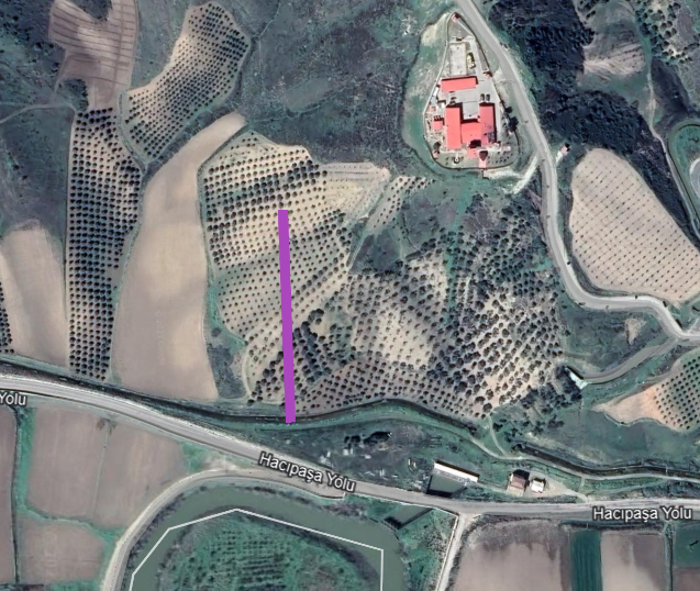
click on image to explore this site on a new tab in Google Earth - Approximate location of Yazlik Trench
in Google Earth
 Approximate location of Yazlik Trench (in magenta)
click on image to explore this site on a new tab in Google Earth - Approximate location of Harabe Trench
in Google Earth
 Approximate location of Harabe Trench (in magenta)
click on image to explore this site on a new tab in Google Earth
Trench Logs
Location Map
- from Akyuz et al. (2006)
Fig. 2
Simplified map of the offset stream beds between the Syrian-Turkish border in south and Amik Basin in north. Note that the western fault does not extend further north of Hacıpaşa town and it does not offset any stream bed. The border between Turkey and Syria is the dashed bold line in south and Asi River. Numbers indicate locations of offset measurements given in Table 2. Map also shows trench locations.
click on image to open in a new tab
Akyuz et al (2006)
Harabe Trench Log

Yazlik Trench Log
Ziyaret Trench Log

Age Model
- from Akyuz et al. (2006)
 Fig. 9
Probability distribution of calibrated 14C ages obtained from sequential radiocarbon dates
clcik on image to open in a new tab
Akyuz et al (2006)
Radiocarbon Dates
- from Akyuz et al. (2006)
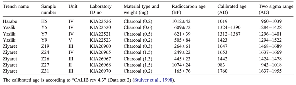 Table 3
Radiocarbon dates from trenches across the Hacıpaşa fault
clcik on image to open in a new tab
Akyuz et al (2006)
Oldest Event - before 943–1018 CE
Discussion
Akyuz et al. (2006)
Abstract
The northern part of the Dead Sea Fault Zone is one of the major active neotectonic structures of Turkey. The main trace of the fault zone (called Hacıpaşa fault) is mapped in detail in Turkey on the basis of morphological and geological evidence such as offset creeks, fault surfaces, shutter ridges and linear escarpments. Three trenches were opened on the investigated part of the fault zone. Trench studies provided evidence for 3 historical earthquakes and comparing trench data with historical earthquake records showed that these earthquakes occurred in 859 AD, 1408 and 1872. Field evidence, palaeoseismological studies and historical earthquake records indicate that the Hacıpaşa fault takes the significant amount of slip in the northern part of the Dead Sea Fault Zone in Turkey. On the basis of palaeoseismological evidence, it is suggested that the recurrence interval for surface faulting event is 506±42 years on the Hacıpaşa fault.
4. Results of palaeoseismological trenching
Introduction
In order to obtain detailed information on the frequency of surface faulting earthquakes, we excavated palaeoseismological trenches on the northern part of the DSFZ (Fig. 2). The palaeoseismological sites are located between the Syrian-Turkish border and Amik Basin where the fault trace is unusually simple (Fig. 4). The trenches were dug in colluvial and alluvial sediments deposited by nearby streams (Figs. 2 and 4). Age estimates of the deposits exposed within the trenches are based on selected charcoal fragments collected from deposits (calibrated age is according to Stuiver et al., 1998 and atmospheric data is taken from Reimer et al., 2004). Results of the age dating are given in Table 3.
4.1. Harabe trench
The Harabe trench is located about 4 km north of the Syrian border (Fig. 2). The fault at this location is characterised by faulted colluvial deposits and deflected stream beds on an east facing slope (Fig. 4a). Eastward-flowing gullies are sinistrally diverted in this location and the cumulative offset ranges from 14 ± 0.5 m to 20 ± 0.5 m. The trench was excavated in the northern side of the southernmost stream bed (Fig. 4a).
Fig. 5 depicts the strata and fault zone that were exposed in Harabe trench. Trench crosses a 2-m-wide fault zone characterised by nearly vertical fault traces and an associated 30-cm-wide fissure fill. Unit C includes reddish sand with limestone blocks which is derived from upper hillside. Since its eastern side is bounded by the fault, it is likely that this unit is a colluvial wedge. Fissure fill and faults which offset the colluvial wedge are overlain by channel deposits. The significance of the stratigraphic relations exposed in Harabe trench includes documentation of two or possibly three surface rupture events. Considering that Unit C is a colluvial wedge, it represents the oldest event which occurred after the deposition of Unit II and before the deposition of Unit III. Fault cutting Unit III (at 3rd m in the trench log) is evidence for the second event which took place before the deposition of Unit IV. The youngest event cuts Unit IV and overlain by the channel deposits. Charcoal samples were collected and analysed to bracket the age of events (Fig. 5). Unfortunately, we were unable to bracket the age of the oldest and youngest events because charcoal samples H1, H3 and H6 have no sufficient amount of carbon for reliable dating. Sample H5 yielded calibrated age of about 1019 A.D., suggesting that the penultimate earthquake occurred before 1019 A.D.
4.2. Yazlık trench
Hacıpaşa fault cuts an E–W-trending ridge north of Hacıpaşa and forms a neck on the ridge. The Ayınsadu Stream flows eastward on the northern side of the ridge and the amount of cumulative sinistral displacement is measured as 650 m (Fig. 2 and Table 2). The trench was excavated on the northern side of the stream on a N–S- trending scarp which is about 1 km in length (Fig. 4b).
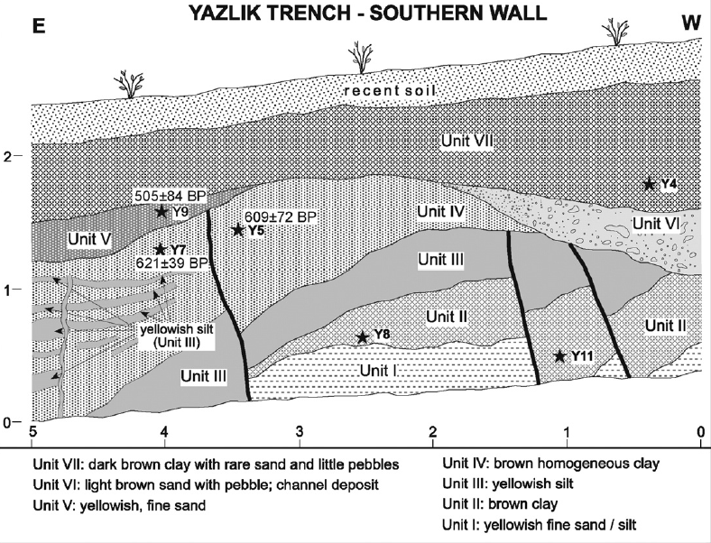
The trench wall clearly shows seven different units (Fig. 6). There is conformity between units I, II and III and two faults cut these units but they do not affect Unit IV which overlies Unit III. Units II, III and IV are blanketed by channel deposits (unit VI) on the western side of the trench wall. Unit IV, which is cut by a fault, is overlain by Unit V on the eastern side. Unit VII covers units IV, V and VI. Horizontal and vertical yellowish silt take place within Unit IV. One of the possible interpretations is that they injected into Unit IV as a result of liquefaction from Unit III.
Yazlık trench provides direct stratigraphical evidence for two past earthquakes. Rupture of the older event cuts units I, II and III and these faults, possibly representing the same event, are covered by units IV and VI on the western side of the trench wall. A younger fault cuts units I to IV and is blanketed by unit V. Samples were collected from stratified units in the trench wall in order to determine precise ages of events but only four samples were sufficient for dating. Samples Y5 and Y7, analysed from Unit IV and yielding calibrated ages between 1312 and 1390 A.D., are the upper boundary for the older event and the lower boundary for the younger event. Sample Y9, analysed from Unit V which covers the younger event, gave a calibrated age of 1423 A.D. Thus, the stratigraphical relationships and age results suggest that the older event occurred before 1350 ± 40 A.D. and the younger event took place sometime between 1350 ± 40 A.D. and 1423 A.D. Liquefaction structures within Unit IV are most likely the result of the younger event.
4.3. Ziyaret trench
The Ziyaret trench site is located close to the southern margin of the Amik Basin (Fig. 2). The trench was dug in the northern side of an eastward flowing stream bed which is sinistrally offset 68 ± 1 m (Figs. 4c, 7). The most distinctive topographic feature in this location is that a hill obstructs the stream as a result of faulting and forms a shutter ridge (Fig. 7).
Fig. 8 shows the log of Ziyaret trench. Pre-Quaternary siltstone exposes at the base in the western side of the trench. The trench wall shows four different units in Holocene age, Units I, II, III and IV. The contact between Unit I and Unit IV is vertical and characterised by sub-parallel fault traces which may reflect more than one event. The total width of the deformation zone exposed in the trench wall is about 9 m (Fig. 8).
The Ziyaret trench wall displays clear evidence for three earthquakes. The older event cuts Unit I and overlain by Unit II. Three faults cut both Units I and II but they do not affect Unit III and thus they represent the penultimate event. The youngest event corresponds with a wide deformation zone which is blanked by recent soil. Samples for precise dating were collected from different levels but only four samples gave sufficient results. Sample Z27 gave a calibrated age of 983 A.D. which indicates that the older event occurred before 983 A.D. Sample Z26 was taken near the base of Unit III and gave a calibrated age of 1442 A.D. This sample gives the upper limit for the penultimate event. Samples Z19, Z31 and Z24 were taken from the upper parts of Unit III and Unit IV, and gave calibrated ages of 1647 A.D., 1677 A.D. and 1653 A.D., respectively. Although Z24 was taken from different unit (Unit IV), these three samples gave similar ages; Z24 probably deposited simultaneously in a different environment and juxtaposed with Unit I, II and III as a result of faulting. These ages suggest that the youngest event took place after about 1650 A.D.
5. Discussion and conclusions
The DSFZ enters Turkey along the western side of the Asi River and it provides geological and morphological evidence up to Amik Basin in north (Figs. 1b and 2). This part of the fault zone between the Syrian-Turkish border in south and Amik Basin in north is named as Hacıpaşa fault. Detailed field investigations on the Hacıpaşa fault showed sinistrally offset stream beds up to 650 m (Figs. 2 and 4, Table 2), and faulted alluvial and colluvial deposits which indicate evidence for its activity.
Historical records listed in Table 1 indicate that there were large earthquakes on the northern part of DSFZ (Ergin et al., 1967; Poirier and Taher, 1980; Soysal et al., 1981; Karaki, 1987; Ambraseys, 1989; Guidoboni et al., 1994; Ambraseys and Melville, 1995; Ambraseys and White, 1997; Khair et al., 2000; Meghraoui et al., 2003; Guidoboni et al., 2004). However, there was no enough historical account about their locations and whether they involved surface rupture or not. Only Ambraseys and Melville (1995) reported that the 1408 earthquake was associated with surface rupture in northern Syria but they claim that the northern end of the rupture should be south of Antioch (modern Antakya).
Results of palaeoseismological studies show that repeated surface faulting earthquakes occurred on the Hacıpaşa fault (Fig. 9). The trench sites across the fault provided evidence of three events. Samples H5 (from Harabe Trench) and Z27 (from Ziyaret Trench) suggest an earthquake before 1019 A.D. and 983 A.D., respectively. Samples Y5 and Y7 (from Yazlık trench) indicate that there was an event before 1350 ± 40 A.D. These ages are the upper boundary for the oldest event in trenches and they probably reflect the same earthquake. Considering historical records, there were some large earthquakes in 859, 1157 and 1169 (or 1170) in the area (Table 1). According to Meghraoui et al. (2003), the 1157 earthquake took place in south of Ghab basin and the 1169 (or 1170) event occurred further south, in the Misyaf segment. Thus, on the basis of above account and our palaeoseismological evidence, it is possible that the oldest event observed in trenches corresponds with the 859 A.D. earthquake.
Trench data in Harabe site provides evidence for an event after 1019 A.D. (H5) but there is no date for its upper boundary. Palaeoseismological evidence in Yazlık and Ziyaret trenches suggests that the penultimate event took place sometime between 1350 ± 40 A.D. and 1423 A.D., and before 1442 A.D., respectively. The recorded historical earthquake was the 1408 event in this period (Table 1) and according to Ambraseys and Melville (1995), this earthquake involved about 20 km surface rupture. In view of the historical records and of palaeoseismological evidence, it is concluded that the last event in Harabe and Yazlık trenches, and the penultimate event in Ziyaret trench occurred in 1408 A.D. Ambraseys and Melville (1995) suggest that the northern end of the 1408 event surface rupture terminated in south of Antioch (modern Antakya) but palaeoseismological studies suggest that the Hacıpaşa fault also ruptured in 1408 and the rupture extended up to Amik Basin in north.
Ziyaret trench suggests that the last reactivation of the Hacıpaşa fault took place after 1650 A.D. (samples Z19 and Z24). Taking into account historical records, the only recorded large event on the northern part of the DSFZ is the 1872 event after 1650 A.D. (Table 1). In addition, Ambraseys (1989) reports that the April 3, 1872 earthquake gave heavy damage in north and south of the former Amik Lake, particularly in the eastern side of the Asi River around Armenez (Fig. 1b). Harabe and Yazlık trenches do not provide any evidence about the 1872 event and the last earthquake in these trenches is the 1408 earthquake. There are two possible explanations for the absence of 1872 rupture in Harabe and Yazlık trenches: either the 1872 rupture is out of the trench and could not be observed or the 1872 earthquake took place in the Amik Basin and its rupture did not extend up to the southern part of the Hacıpaşa fault. Taking into account the second explanation, it is clear that there has been a significant amount of slip deficit since 1408.
Although there is a limited number of radiocarbon dates, the recurrence interval for surface-faulting events appears to range from 464 to 549 years (Fig. 9). This interval is not well constrained but at least it gives an idea about the basic kinematic parameters (such as slip rate) which are not documented for the northern part of the DSFZ. Meghraoui et al. (2003) and Westaway (2003) suggested that the average slip rate for the DSFZ in Syria is about 6–7 mm yr-1. Previous studies (e.g. Perinçek and Çemen, 1990; Perinçek and Eren, 1990; McClusky et al., 2000; Yurtmen et al., 2002; Adiyaman and Chorowicz, 2002; Westaway, 2003, 2004) suggest that the DSFZ branches in southern Turkey and, thus the slip rate is partitioned. For example, Westaway (2004) claims that the average slip rate is not more than 2 mm yr-1 for each branch of the DSFZ in Turkey. Although our palaeoseismological studies did not provide any evidence for the amount of lateral offset for each event, the recurrence time of large earthquakes suggests that there is a considerable slip on the Hacıpaşa fault. Three surface rupturing events are interpreted to have occurred on the Hacıpaşa fault at least in the last 1200 years. Although there is no reliable information about the magnitude of these earthquakes in historical catalogues, Ambraseys (1989) suggests 7.2 magnitude for the 1872 earthquake. Meghraoui et al. (2003) suggest that the 1408 earthquake was larger than 7.5. Furthermore, detailed studies on other fault zones showed that M= 7 or larger earthquakes were associated with surface rupture and average offset of 2–3 m. For example it was 3 m for the 1912 Mürefte-Sarköy, M= 7.4, earthquake (Altunel et al., 2004), 2–4 m for the 1944 Bolu-Gerede, M= 7.3, earthquake (Kondo et al., 2005), 2.5–3 m for the 1999 Düzce earthquake (Akyuz et al., 2002) and 3 m for the Izmit, M= 7.4, earthquake (Barka et al., 2002). Considering that historical earthquakes revealed from trenches involved surface faulting, it can be assumed that they were at least magnitude 7 or more and were associated with an average offset of 2–3 m. Based on above accounts, it is clear that the Hacıpaşa fault takes the significant amount of slip in the northern part of the DSFZ. A remarkable observation from the present trenches is that the southern trenches (Harabe and Yazlık) do not provide evidence for the 1872 earthquake. This situation needs further detailed investigations because if the 1872 earthquake did not take place along the Hacıpaşa fault, there has been a significant amount of slip deficit since 1408 which constrains the size of the future earthquake more than magnitude 7 on this part of the DSFZ.
Penultimate Event - between 1310 and 1423 CE
Discussion
Akyuz et al. (2006)
Abstract
The northern part of the Dead Sea Fault Zone is one of the major active neotectonic structures of Turkey. The main trace of the fault zone (called Hacıpaşa fault) is mapped in detail in Turkey on the basis of morphological and geological evidence such as offset creeks, fault surfaces, shutter ridges and linear escarpments. Three trenches were opened on the investigated part of the fault zone. Trench studies provided evidence for 3 historical earthquakes and comparing trench data with historical earthquake records showed that these earthquakes occurred in 859 AD, 1408 and 1872. Field evidence, palaeoseismological studies and historical earthquake records indicate that the Hacıpaşa fault takes the significant amount of slip in the northern part of the Dead Sea Fault Zone in Turkey. On the basis of palaeoseismological evidence, it is suggested that the recurrence interval for surface faulting event is 506±42 years on the Hacıpaşa fault.
4. Results of palaeoseismological trenching
Introduction
In order to obtain detailed information on the frequency of surface faulting earthquakes, we excavated palaeoseismological trenches on the northern part of the DSFZ (Fig. 2). The palaeoseismological sites are located between the Syrian-Turkish border and Amik Basin where the fault trace is unusually simple (Fig. 4). The trenches were dug in colluvial and alluvial sediments deposited by nearby streams (Figs. 2 and 4). Age estimates of the deposits exposed within the trenches are based on selected charcoal fragments collected from deposits (calibrated age is according to Stuiver et al., 1998 and atmospheric data is taken from Reimer et al., 2004). Results of the age dating are given in Table 3.
4.1. Harabe trench
The Harabe trench is located about 4 km north of the Syrian border (Fig. 2). The fault at this location is characterised by faulted colluvial deposits and deflected stream beds on an east facing slope (Fig. 4a). Eastward-flowing gullies are sinistrally diverted in this location and the cumulative offset ranges from 14 ± 0.5 m to 20 ± 0.5 m. The trench was excavated in the northern side of the southernmost stream bed (Fig. 4a).
Fig. 5 depicts the strata and fault zone that were exposed in Harabe trench. Trench crosses a 2-m-wide fault zone characterised by nearly vertical fault traces and an associated 30-cm-wide fissure fill. Unit C includes reddish sand with limestone blocks which is derived from upper hillside. Since its eastern side is bounded by the fault, it is likely that this unit is a colluvial wedge. Fissure fill and faults which offset the colluvial wedge are overlain by channel deposits. The significance of the stratigraphic relations exposed in Harabe trench includes documentation of two or possibly three surface rupture events. Considering that Unit C is a colluvial wedge, it represents the oldest event which occurred after the deposition of Unit II and before the deposition of Unit III. Fault cutting Unit III (at 3rd m in the trench log) is evidence for the second event which took place before the deposition of Unit IV. The youngest event cuts Unit IV and overlain by the channel deposits. Charcoal samples were collected and analysed to bracket the age of events (Fig. 5). Unfortunately, we were unable to bracket the age of the oldest and youngest events because charcoal samples H1, H3 and H6 have no sufficient amount of carbon for reliable dating. Sample H5 yielded calibrated age of about 1019 A.D., suggesting that the penultimate earthquake occurred before 1019 A.D.
4.2. Yazlık trench
Hacıpaşa fault cuts an E–W-trending ridge north of Hacıpaşa and forms a neck on the ridge. The Ayınsadu Stream flows eastward on the northern side of the ridge and the amount of cumulative sinistral displacement is measured as 650 m (Fig. 2 and Table 2). The trench was excavated on the northern side of the stream on a N–S- trending scarp which is about 1 km in length (Fig. 4b).
The trench wall clearly shows seven different units (Fig. 6). There is conformity between units I, II and III and two faults cut these units but they do not affect Unit IV which overlies Unit III. Units II, III and IV are blanketed by channel deposits (unit VI) on the western side of the trench wall. Unit IV, which is cut by a fault, is overlain by Unit V on the eastern side. Unit VII covers units IV, V and VI. Horizontal and vertical yellowish silt take place within Unit IV. One of the possible interpretations is that they injected into Unit IV as a result of liquefaction from Unit III.
Yazlık trench provides direct stratigraphical evidence for two past earthquakes. Rupture of the older event cuts units I, II and III and these faults, possibly representing the same event, are covered by units IV and VI on the western side of the trench wall. A younger fault cuts units I to IV and is blanketed by unit V. Samples were collected from stratified units in the trench wall in order to determine precise ages of events but only four samples were sufficient for dating. Samples Y5 and Y7, analysed from Unit IV and yielding calibrated ages between 1312 and 1390 A.D., are the upper boundary for the older event and the lower boundary for the younger event. Sample Y9, analysed from Unit V which covers the younger event, gave a calibrated age of 1423 A.D. Thus, the stratigraphical relationships and age results suggest that the older event occurred before 1350 ± 40 A.D. and the younger event took place sometime between 1350 ± 40 A.D. and 1423 A.D. Liquefaction structures within Unit IV are most likely the result of the younger event.
4.3. Ziyaret trench
The Ziyaret trench site is located close to the southern margin of the Amik Basin (Fig. 2). The trench was dug in the northern side of an eastward flowing stream bed which is sinistrally offset 68 ± 1 m (Figs. 4c, 7). The most distinctive topographic feature in this location is that a hill obstructs the stream as a result of faulting and forms a shutter ridge (Fig. 7).
Fig. 8 shows the log of Ziyaret trench. Pre-Quaternary siltstone exposes at the base in the western side of the trench. The trench wall shows four different units in Holocene age, Units I, II, III and IV. The contact between Unit I and Unit IV is vertical and characterised by sub-parallel fault traces which may reflect more than one event. The total width of the deformation zone exposed in the trench wall is about 9 m (Fig. 8).
The Ziyaret trench wall displays clear evidence for three earthquakes. The older event cuts Unit I and overlain by Unit II. Three faults cut both Units I and II but they do not affect Unit III and thus they represent the penultimate event. The youngest event corresponds with a wide deformation zone which is blanked by recent soil. Samples for precise dating were collected from different levels but only four samples gave sufficient results. Sample Z27 gave a calibrated age of 983 A.D. which indicates that the older event occurred before 983 A.D. Sample Z26 was taken near the base of Unit III and gave a calibrated age of 1442 A.D. This sample gives the upper limit for the penultimate event. Samples Z19, Z31 and Z24 were taken from the upper parts of Unit III and Unit IV, and gave calibrated ages of 1647 A.D., 1677 A.D. and 1653 A.D., respectively. Although Z24 was taken from different unit (Unit IV), these three samples gave similar ages; Z24 probably deposited simultaneously in a different environment and juxtaposed with Unit I, II and III as a result of faulting. These ages suggest that the youngest event took place after about 1650 A.D.
5. Discussion and conclusions
The DSFZ enters Turkey along the western side of the Asi River and it provides geological and morphological evidence up to Amik Basin in north (Figs. 1b and 2). This part of the fault zone between the Syrian-Turkish border in south and Amik Basin in north is named as Hacıpaşa fault. Detailed field investigations on the Hacıpaşa fault showed sinistrally offset stream beds up to 650 m (Figs. 2 and 4, Table 2), and faulted alluvial and colluvial deposits which indicate evidence for its activity.
Historical records listed in Table 1 indicate that there were large earthquakes on the northern part of DSFZ (Ergin et al., 1967; Poirier and Taher, 1980; Soysal et al., 1981; Karaki, 1987; Ambraseys, 1989; Guidoboni et al., 1994; Ambraseys and Melville, 1995; Ambraseys and White, 1997; Khair et al., 2000; Meghraoui et al., 2003; Guidoboni et al., 2004). However, there was no enough historical account about their locations and whether they involved surface rupture or not. Only Ambraseys and Melville (1995) reported that the 1408 earthquake was associated with surface rupture in northern Syria but they claim that the northern end of the rupture should be south of Antioch (modern Antakya).
Results of palaeoseismological studies show that repeated surface faulting earthquakes occurred on the Hacıpaşa fault (Fig. 9). The trench sites across the fault provided evidence of three events. Samples H5 (from Harabe Trench) and Z27 (from Ziyaret Trench) suggest an earthquake before 1019 A.D. and 983 A.D., respectively. Samples Y5 and Y7 (from Yazlık trench) indicate that there was an event before 1350 ± 40 A.D. These ages are the upper boundary for the oldest event in trenches and they probably reflect the same earthquake. Considering historical records, there were some large earthquakes in 859, 1157 and 1169 (or 1170) in the area (Table 1). According to Meghraoui et al. (2003), the 1157 earthquake took place in south of Ghab basin and the 1169 (or 1170) event occurred further south, in the Misyaf segment. Thus, on the basis of above account and our palaeoseismological evidence, it is possible that the oldest event observed in trenches corresponds with the 859 A.D. earthquake.
Trench data in Harabe site provides evidence for an event after 1019 A.D. (H5) but there is no date for its upper boundary. Palaeoseismological evidence in Yazlık and Ziyaret trenches suggests that the penultimate event took place sometime between 1350 ± 40 A.D. and 1423 A.D., and before 1442 A.D., respectively. The recorded historical earthquake was the 1408 event in this period (Table 1) and according to Ambraseys and Melville (1995), this earthquake involved about 20 km surface rupture. In view of the historical records and of palaeoseismological evidence, it is concluded that the last event in Harabe and Yazlık trenches, and the penultimate event in Ziyaret trench occurred in 1408 A.D. Ambraseys and Melville (1995) suggest that the northern end of the 1408 event surface rupture terminated in south of Antioch (modern Antakya) but palaeoseismological studies suggest that the Hacıpaşa fault also ruptured in 1408 and the rupture extended up to Amik Basin in north.
Ziyaret trench suggests that the last reactivation of the Hacıpaşa fault took place after 1650 A.D. (samples Z19 and Z24). Taking into account historical records, the only recorded large event on the northern part of the DSFZ is the 1872 event after 1650 A.D. (Table 1). In addition, Ambraseys (1989) reports that the April 3, 1872 earthquake gave heavy damage in north and south of the former Amik Lake, particularly in the eastern side of the Asi River around Armenez (Fig. 1b). Harabe and Yazlık trenches do not provide any evidence about the 1872 event and the last earthquake in these trenches is the 1408 earthquake. There are two possible explanations for the absence of 1872 rupture in Harabe and Yazlık trenches: either the 1872 rupture is out of the trench and could not be observed or the 1872 earthquake took place in the Amik Basin and its rupture did not extend up to the southern part of the Hacıpaşa fault. Taking into account the second explanation, it is clear that there has been a significant amount of slip deficit since 1408.
Although there is a limited number of radiocarbon dates, the recurrence interval for surface-faulting events appears to range from 464 to 549 years (Fig. 9). This interval is not well constrained but at least it gives an idea about the basic kinematic parameters (such as slip rate) which are not documented for the northern part of the DSFZ. Meghraoui et al. (2003) and Westaway (2003) suggested that the average slip rate for the DSFZ in Syria is about 6–7 mm yr-1. Previous studies (e.g. Perinçek and Çemen, 1990; Perinçek and Eren, 1990; McClusky et al., 2000; Yurtmen et al., 2002; Adiyaman and Chorowicz, 2002; Westaway, 2003, 2004) suggest that the DSFZ branches in southern Turkey and, thus the slip rate is partitioned. For example, Westaway (2004) claims that the average slip rate is not more than 2 mm yr-1 for each branch of the DSFZ in Turkey. Although our palaeoseismological studies did not provide any evidence for the amount of lateral offset for each event, the recurrence time of large earthquakes suggests that there is a considerable slip on the Hacıpaşa fault. Three surface rupturing events are interpreted to have occurred on the Hacıpaşa fault at least in the last 1200 years. Although there is no reliable information about the magnitude of these earthquakes in historical catalogues, Ambraseys (1989) suggests 7.2 magnitude for the 1872 earthquake. Meghraoui et al. (2003) suggest that the 1408 earthquake was larger than 7.5. Furthermore, detailed studies on other fault zones showed that M= 7 or larger earthquakes were associated with surface rupture and average offset of 2–3 m. For example it was 3 m for the 1912 Mürefte-Sarköy, M= 7.4, earthquake (Altunel et al., 2004), 2–4 m for the 1944 Bolu-Gerede, M= 7.3, earthquake (Kondo et al., 2005), 2.5–3 m for the 1999 Düzce earthquake (Akyuz et al., 2002) and 3 m for the Izmit, M= 7.4, earthquake (Barka et al., 2002). Considering that historical earthquakes revealed from trenches involved surface faulting, it can be assumed that they were at least magnitude 7 or more and were associated with an average offset of 2–3 m. Based on above accounts, it is clear that the Hacıpaşa fault takes the significant amount of slip in the northern part of the DSFZ. A remarkable observation from the present trenches is that the southern trenches (Harabe and Yazlık) do not provide evidence for the 1872 earthquake. This situation needs further detailed investigations because if the 1872 earthquake did not take place along the Hacıpaşa fault, there has been a significant amount of slip deficit since 1408 which constrains the size of the future earthquake more than magnitude 7 on this part of the DSFZ.
Youngest Event - after ~1650 CE
Discussion
Akyuz et al. (2006)
Abstract
The northern part of the Dead Sea Fault Zone is one of the major active neotectonic structures of Turkey. The main trace of the fault zone (called Hacıpaşa fault) is mapped in detail in Turkey on the basis of morphological and geological evidence such as offset creeks, fault surfaces, shutter ridges and linear escarpments. Three trenches were opened on the investigated part of the fault zone. Trench studies provided evidence for 3 historical earthquakes and comparing trench data with historical earthquake records showed that these earthquakes occurred in 859 AD, 1408 and 1872. Field evidence, palaeoseismological studies and historical earthquake records indicate that the Hacıpaşa fault takes the significant amount of slip in the northern part of the Dead Sea Fault Zone in Turkey. On the basis of palaeoseismological evidence, it is suggested that the recurrence interval for surface faulting event is 506±42 years on the Hacıpaşa fault.
4. Results of palaeoseismological trenching
Introduction
In order to obtain detailed information on the frequency of surface faulting earthquakes, we excavated palaeoseismological trenches on the northern part of the DSFZ (Fig. 2). The palaeoseismological sites are located between the Syrian-Turkish border and Amik Basin where the fault trace is unusually simple (Fig. 4). The trenches were dug in colluvial and alluvial sediments deposited by nearby streams (Figs. 2 and 4). Age estimates of the deposits exposed within the trenches are based on selected charcoal fragments collected from deposits (calibrated age is according to Stuiver et al., 1998 and atmospheric data is taken from Reimer et al., 2004). Results of the age dating are given in Table 3.
4.1. Harabe trench
The Harabe trench is located about 4 km north of the Syrian border (Fig. 2). The fault at this location is characterised by faulted colluvial deposits and deflected stream beds on an east facing slope (Fig. 4a). Eastward-flowing gullies are sinistrally diverted in this location and the cumulative offset ranges from 14 ± 0.5 m to 20 ± 0.5 m. The trench was excavated in the northern side of the southernmost stream bed (Fig. 4a).
Fig. 5 depicts the strata and fault zone that were exposed in Harabe trench. Trench crosses a 2-m-wide fault zone characterised by nearly vertical fault traces and an associated 30-cm-wide fissure fill. Unit C includes reddish sand with limestone blocks which is derived from upper hillside. Since its eastern side is bounded by the fault, it is likely that this unit is a colluvial wedge. Fissure fill and faults which offset the colluvial wedge are overlain by channel deposits. The significance of the stratigraphic relations exposed in Harabe trench includes documentation of two or possibly three surface rupture events. Considering that Unit C is a colluvial wedge, it represents the oldest event which occurred after the deposition of Unit II and before the deposition of Unit III. Fault cutting Unit III (at 3rd m in the trench log) is evidence for the second event which took place before the deposition of Unit IV. The youngest event cuts Unit IV and overlain by the channel deposits. Charcoal samples were collected and analysed to bracket the age of events (Fig. 5). Unfortunately, we were unable to bracket the age of the oldest and youngest events because charcoal samples H1, H3 and H6 have no sufficient amount of carbon for reliable dating. Sample H5 yielded calibrated age of about 1019 A.D., suggesting that the penultimate earthquake occurred before 1019 A.D.
4.2. Yazlık trench
Hacıpaşa fault cuts an E–W-trending ridge north of Hacıpaşa and forms a neck on the ridge. The Ayınsadu Stream flows eastward on the northern side of the ridge and the amount of cumulative sinistral displacement is measured as 650 m (Fig. 2 and Table 2). The trench was excavated on the northern side of the stream on a N–S- trending scarp which is about 1 km in length (Fig. 4b).
The trench wall clearly shows seven different units (Fig. 6). There is conformity between units I, II and III and two faults cut these units but they do not affect Unit IV which overlies Unit III. Units II, III and IV are blanketed by channel deposits (unit VI) on the western side of the trench wall. Unit IV, which is cut by a fault, is overlain by Unit V on the eastern side. Unit VII covers units IV, V and VI. Horizontal and vertical yellowish silt take place within Unit IV. One of the possible interpretations is that they injected into Unit IV as a result of liquefaction from Unit III.
Yazlık trench provides direct stratigraphical evidence for two past earthquakes. Rupture of the older event cuts units I, II and III and these faults, possibly representing the same event, are covered by units IV and VI on the western side of the trench wall. A younger fault cuts units I to IV and is blanketed by unit V. Samples were collected from stratified units in the trench wall in order to determine precise ages of events but only four samples were sufficient for dating. Samples Y5 and Y7, analysed from Unit IV and yielding calibrated ages between 1312 and 1390 A.D., are the upper boundary for the older event and the lower boundary for the younger event. Sample Y9, analysed from Unit V which covers the younger event, gave a calibrated age of 1423 A.D. Thus, the stratigraphical relationships and age results suggest that the older event occurred before 1350 ± 40 A.D. and the younger event took place sometime between 1350 ± 40 A.D. and 1423 A.D. Liquefaction structures within Unit IV are most likely the result of the younger event.
4.3. Ziyaret trench
The Ziyaret trench site is located close to the southern margin of the Amik Basin (Fig. 2). The trench was dug in the northern side of an eastward flowing stream bed which is sinistrally offset 68 ± 1 m (Figs. 4c, 7). The most distinctive topographic feature in this location is that a hill obstructs the stream as a result of faulting and forms a shutter ridge (Fig. 7).
Fig. 8 shows the log of Ziyaret trench. Pre-Quaternary siltstone exposes at the base in the western side of the trench. The trench wall shows four different units in Holocene age, Units I, II, III and IV. The contact between Unit I and Unit IV is vertical and characterised by sub-parallel fault traces which may reflect more than one event. The total width of the deformation zone exposed in the trench wall is about 9 m (Fig. 8).
The Ziyaret trench wall displays clear evidence for three earthquakes. The older event cuts Unit I and overlain by Unit II. Three faults cut both Units I and II but they do not affect Unit III and thus they represent the penultimate event. The youngest event corresponds with a wide deformation zone which is blanked by recent soil. Samples for precise dating were collected from different levels but only four samples gave sufficient results. Sample Z27 gave a calibrated age of 983 A.D. which indicates that the older event occurred before 983 A.D. Sample Z26 was taken near the base of Unit III and gave a calibrated age of 1442 A.D. This sample gives the upper limit for the penultimate event. Samples Z19, Z31 and Z24 were taken from the upper parts of Unit III and Unit IV, and gave calibrated ages of 1647 A.D., 1677 A.D. and 1653 A.D., respectively. Although Z24 was taken from different unit (Unit IV), these three samples gave similar ages; Z24 probably deposited simultaneously in a different environment and juxtaposed with Unit I, II and III as a result of faulting. These ages suggest that the youngest event took place after about 1650 A.D.
5. Discussion and conclusions
The DSFZ enters Turkey along the western side of the Asi River and it provides geological and morphological evidence up to Amik Basin in north (Figs. 1b and 2). This part of the fault zone between the Syrian-Turkish border in south and Amik Basin in north is named as Hacıpaşa fault. Detailed field investigations on the Hacıpaşa fault showed sinistrally offset stream beds up to 650 m (Figs. 2 and 4, Table 2), and faulted alluvial and colluvial deposits which indicate evidence for its activity.
Historical records listed in Table 1 indicate that there were large earthquakes on the northern part of DSFZ (Ergin et al., 1967; Poirier and Taher, 1980; Soysal et al., 1981; Karaki, 1987; Ambraseys, 1989; Guidoboni et al., 1994; Ambraseys and Melville, 1995; Ambraseys and White, 1997; Khair et al., 2000; Meghraoui et al., 2003; Guidoboni et al., 2004). However, there was no enough historical account about their locations and whether they involved surface rupture or not. Only Ambraseys and Melville (1995) reported that the 1408 earthquake was associated with surface rupture in northern Syria but they claim that the northern end of the rupture should be south of Antioch (modern Antakya).
Results of palaeoseismological studies show that repeated surface faulting earthquakes occurred on the Hacıpaşa fault (Fig. 9). The trench sites across the fault provided evidence of three events. Samples H5 (from Harabe Trench) and Z27 (from Ziyaret Trench) suggest an earthquake before 1019 A.D. and 983 A.D., respectively. Samples Y5 and Y7 (from Yazlık trench) indicate that there was an event before 1350 ± 40 A.D. These ages are the upper boundary for the oldest event in trenches and they probably reflect the same earthquake. Considering historical records, there were some large earthquakes in 859, 1157 and 1169 (or 1170) in the area (Table 1). According to Meghraoui et al. (2003), the 1157 earthquake took place in south of Ghab basin and the 1169 (or 1170) event occurred further south, in the Misyaf segment. Thus, on the basis of above account and our palaeoseismological evidence, it is possible that the oldest event observed in trenches corresponds with the 859 A.D. earthquake.
Trench data in Harabe site provides evidence for an event after 1019 A.D. (H5) but there is no date for its upper boundary. Palaeoseismological evidence in Yazlık and Ziyaret trenches suggests that the penultimate event took place sometime between 1350 ± 40 A.D. and 1423 A.D., and before 1442 A.D., respectively. The recorded historical earthquake was the 1408 event in this period (Table 1) and according to Ambraseys and Melville (1995), this earthquake involved about 20 km surface rupture. In view of the historical records and of palaeoseismological evidence, it is concluded that the last event in Harabe and Yazlık trenches, and the penultimate event in Ziyaret trench occurred in 1408 A.D. Ambraseys and Melville (1995) suggest that the northern end of the 1408 event surface rupture terminated in south of Antioch (modern Antakya) but palaeoseismological studies suggest that the Hacıpaşa fault also ruptured in 1408 and the rupture extended up to Amik Basin in north.
Ziyaret trench suggests that the last reactivation of the Hacıpaşa fault took place after 1650 A.D. (samples Z19 and Z24). Taking into account historical records, the only recorded large event on the northern part of the DSFZ is the 1872 event after 1650 A.D. (Table 1). In addition, Ambraseys (1989) reports that the April 3, 1872 earthquake gave heavy damage in north and south of the former Amik Lake, particularly in the eastern side of the Asi River around Armenez (Fig. 1b). Harabe and Yazlık trenches do not provide any evidence about the 1872 event and the last earthquake in these trenches is the 1408 earthquake. There are two possible explanations for the absence of 1872 rupture in Harabe and Yazlık trenches: either the 1872 rupture is out of the trench and could not be observed or the 1872 earthquake took place in the Amik Basin and its rupture did not extend up to the southern part of the Hacıpaşa fault. Taking into account the second explanation, it is clear that there has been a significant amount of slip deficit since 1408.
Although there is a limited number of radiocarbon dates, the recurrence interval for surface-faulting events appears to range from 464 to 549 years (Fig. 9). This interval is not well constrained but at least it gives an idea about the basic kinematic parameters (such as slip rate) which are not documented for the northern part of the DSFZ. Meghraoui et al. (2003) and Westaway (2003) suggested that the average slip rate for the DSFZ in Syria is about 6–7 mm yr-1. Previous studies (e.g. Perinçek and Çemen, 1990; Perinçek and Eren, 1990; McClusky et al., 2000; Yurtmen et al., 2002; Adiyaman and Chorowicz, 2002; Westaway, 2003, 2004) suggest that the DSFZ branches in southern Turkey and, thus the slip rate is partitioned. For example, Westaway (2004) claims that the average slip rate is not more than 2 mm yr-1 for each branch of the DSFZ in Turkey. Although our palaeoseismological studies did not provide any evidence for the amount of lateral offset for each event, the recurrence time of large earthquakes suggests that there is a considerable slip on the Hacıpaşa fault. Three surface rupturing events are interpreted to have occurred on the Hacıpaşa fault at least in the last 1200 years. Although there is no reliable information about the magnitude of these earthquakes in historical catalogues, Ambraseys (1989) suggests 7.2 magnitude for the 1872 earthquake. Meghraoui et al. (2003) suggest that the 1408 earthquake was larger than 7.5. Furthermore, detailed studies on other fault zones showed that M= 7 or larger earthquakes were associated with surface rupture and average offset of 2–3 m. For example it was 3 m for the 1912 Mürefte-Sarköy, M= 7.4, earthquake (Altunel et al., 2004), 2–4 m for the 1944 Bolu-Gerede, M= 7.3, earthquake (Kondo et al., 2005), 2.5–3 m for the 1999 Düzce earthquake (Akyuz et al., 2002) and 3 m for the Izmit, M= 7.4, earthquake (Barka et al., 2002). Considering that historical earthquakes revealed from trenches involved surface faulting, it can be assumed that they were at least magnitude 7 or more and were associated with an average offset of 2–3 m. Based on above accounts, it is clear that the Hacıpaşa fault takes the significant amount of slip in the northern part of the DSFZ. A remarkable observation from the present trenches is that the southern trenches (Harabe and Yazlık) do not provide evidence for the 1872 earthquake. This situation needs further detailed investigations because if the 1872 earthquake did not take place along the Hacıpaşa fault, there has been a significant amount of slip deficit since 1408 which constrains the size of the future earthquake more than magnitude 7 on this part of the DSFZ.
Master Seismic Events Table
References