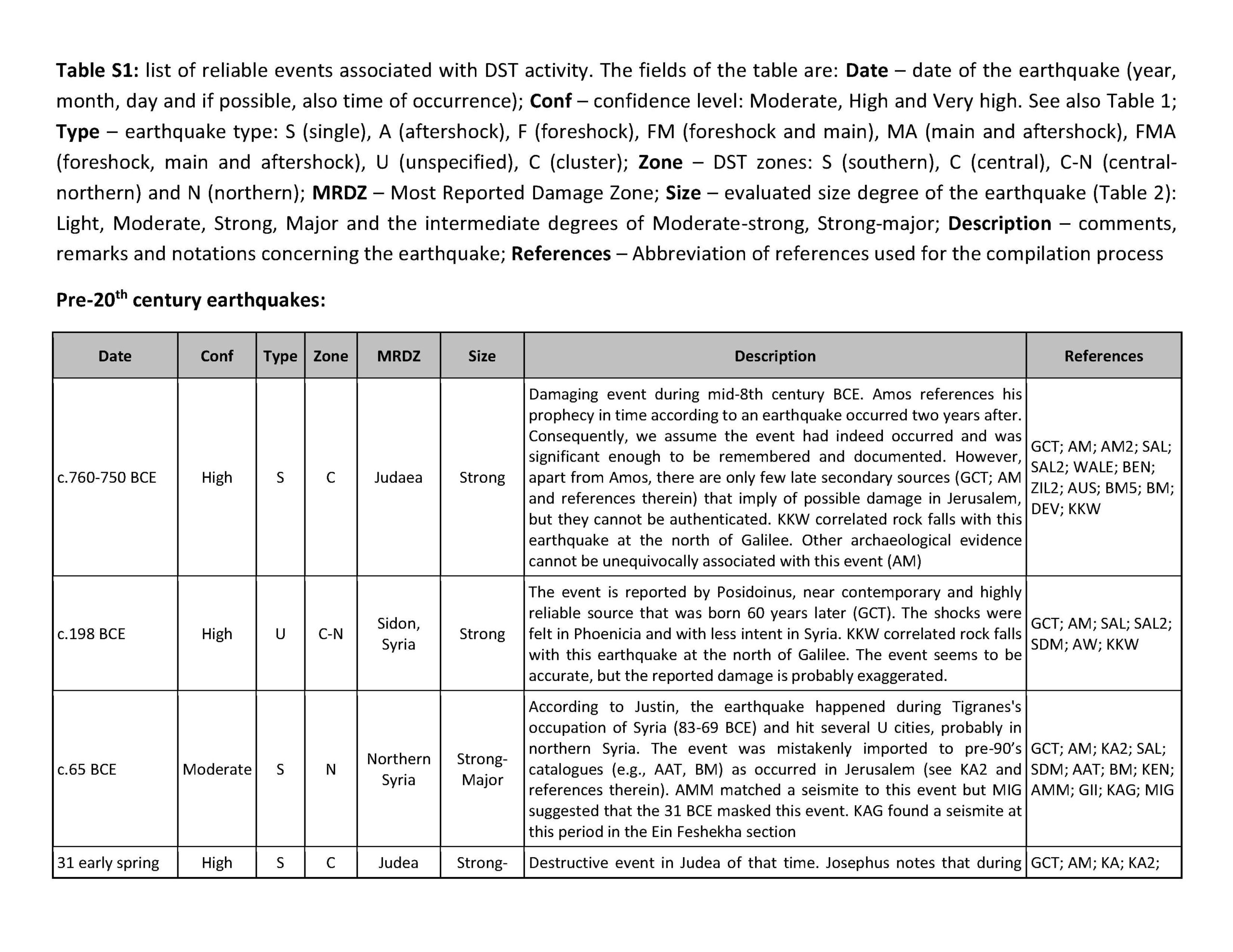
The words of Amos, one of the shepherds of Tekoa — the vision he saw concerning Israel two years before the earthquake, when Uzziah was king of Judah and Jeroboam (II) son of Jehoash [a] was king of IsraelAlthough the specification of the Kings provides chronological information, there is no description of seismic effects or localities. As noted by Austin et. al. (2000) and others, this earthquake may have initiated (or enhanced) a belief in seismic theophany - that God expresses himself through earthquakes (see some examples in Notes). Later prophetic accounts in the Hebrew Bible frequently mention earthquakes. One such account by Zechariah1 prophesied about the "Day of the Lord" and mentions that
you will flee as you fled from the earthquake in the days of Uzziah king of Judah. This appears to reference the same earthquake mentioned in Amos and it adds, via context, a location - Jerusalem. Other text adjacent to this passage mentions a cleaving of the Mount of Olives which created a valley from which people would flee Jerusalem. Although this is ostensibly about a time in the future which precedes Judgment Day, one is left wondering whether it contains echoes of seismic effects (e.g. a landslide on the Mount of Olives) recounted in oral or written lore which fed the imagination of the author of this section of Zechariah. About 850 years later (in ~95 CE), Josephus, without citing a source, wrote an expansive account about the Amos Quake telling a tale where King Uzziah decided to offer incense to God upon the golden altar of the First Temple in Jerusalem. When the Temple Priesthood objected to this transgression, he threatened to kill them. Immediately after,
a great earthquake shook the ground and a rent was made in the temple, and the bright rays of the sun shone through it, and fell upon the king's face, insomuch that the leprosy seized upon him immediately.2 Kings 15:5, thought to have been written in two editions in the late 7th century BCE and mid-late 6th century BCE (wikipedia citing Fretheim , 1997:7 and Grabbe, 2016) mentions that King Uzziah was afflicted by leprosy but does not add any of the narrative details of Josephus. 2 Chronicles 19:19, perhaps written in the 5th century BCE and sometimes using Kings as source material, recounts all of the elements of Josephus except for the earthquake. Josephus goes on to describe a long runout landslide at Eroge (likely Ein Rogel) associated with the earthquake. Later authors such as Avot de-Rabbi Nathan, perhaps originally composed between the 1st and 3rd centuries CE (Goldin, 1995:xxi) and Jerome, writing in 406 CE, repeat the essential elements of Josephus' account - minus the landslide at Ein Rogel.
cannot be precisely dated (sometime around 760). A more precise date requires that we assume that Josephus' chronologically suspect synchronisms are correct. Ben-Menahem (1991), assuming that Josephus' synchronisms are reliable, dated the Amos Quake to the evening of 11 October 759 BCE. This was based on a reasonable supposition that the story of Uzziah and the incense offering would have been meant to take place on 14 Tishrei; the eve before the Tabernacle holiday (aka Sukkot) which was the paramount holiday during the First Temple period. How Ben-Menahem (1991) or anyone else came up with a year of 759 BCE is not clear as it is not specified in Amos 1:2 or any other source. It is possible that this date was suggested due to an assumed allusion in Amos 8:9 to a solar eclipse that occurred in June 762 BCE2. Austin et. al. (2000) also assumed that Josephus' account was reliable but came up with a year of 750 BCE. Ben-Menahem (1991)'s and Austin et. al. (2000)'s dates appear to be flawed as they do not account for the full uncertainty associated with this event.
| Text (with hotlink) | Original Language | Biographical Info | Religion | Date of Composition | Location Composed | Notes |
|---|---|---|---|---|---|---|
| Damage Reports from Textual Sources | n/a | n/a | n/a | n/a | n/a | n/a |
| Dating from Textual Sources | n/a | n/a | n/a | n/a | n/a | The first line of the Book of Amos specifies that Amos prophesied while
King Uzziah ruled Judah and
King Jeroboam (II) ruled Israel
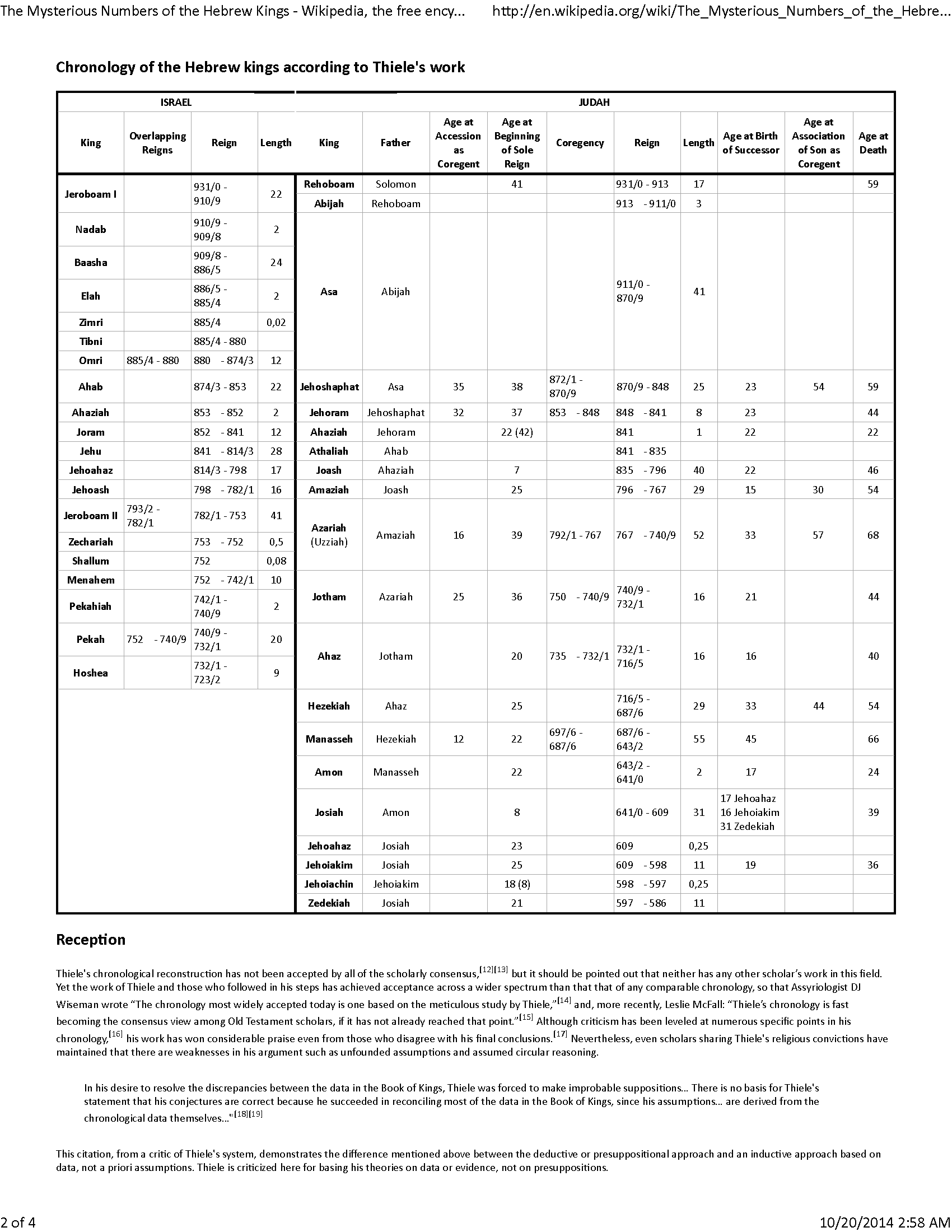
and the earthquake struck two years later. If we use Thiele (1983)'s widely accepted chronology of the Kings,
the Amos Quake struck between 766/765 and 751 BCE.
Schoors (2013:115) noted that the Amos Quake cannot be precisely dated (sometime around 760). A more precise date requires that we assume that Josephus' chronologically suspect synchronisms written about ~850 years after the event are correct. Josephus states that when King Uzziah tried to burn incense in the Temple, an earthquake damaged the Temple and he was struck with leprosy or leprosy was first recognized on him. Ben-Menahem (1991), assuming that Josephus' synchronisms are reliable, dated the Amos Quake to the evening of 11 October 759 BCE. This was based on a reasonable supposition that the story of Uzziah and the incense would have been meant to take place on 14 Tishrei, the eve before the Tabernacle holiday (aka Sukkot) which was the paramount holiday during the First Temple period. How Ben-Menahem (1991) or anyone else came up with a year of 759 BCE is not clear as it is not specified in Amos 1:2 or any other source. It is possible, this date was suggested due to an assumed allusion in Amos 8:9 to a solar eclipse that occurred in June 762 BCE. Austin et. al. (2000) also assumed that Josephus' account was reliable but came up with a year of 750 BCE. Ben-Menahem (1991)'s and Austin et. al. (2000)'s dates appear to be flawed as they do not account for the full uncertainty associated with this event. Josephus' uncited and chronologically suspect synchronisms cannot be relied on with certainty. |
| Amos | Hebrew |
|
Jewish |
Niehaus in McComiskey (2020:316-317) suggest that it is likely that [Amos] prophesied late in Jeroboam [II]'s reign, perhaps in the early 760s. |
not entirely known - Bethel and perhaps other locations in the northern Kingdom such as Samaria | Using Thiele's chronology, the first line of the Book of Amos
dates the earthquake to between 766/765 and 751 BCE. No seismic effects or locations were specified. Amos 1:1 - The words of Amos, one of the shepherds of Tekoa — the vision he saw concerning Israel two years before the earthquake, when Uzziah was king of Judah and Jeroboam (II) son of Jehoash [a] was king of Israel. |
| Zechariah | Hebrew |
|
Jewish | unknown - Longman and Dillard (1994:489) note that estimates for the date of the likely anonymous composition of Zechariah 14 vary from the 8th century BCE to the Maccabean period | unknown | In Zechariah 14:5, a prophetic passage likely written by an unknown author at an unknown date about the
"Day of the Lord" mentions that you will flee as you fled from the earthquake [a] in the days of Uzziah king of Judah.Using Thiele's chronology, this dates this earthquake to between 768/767 and 751/750 BCE. The previous sentence (Zechariah 14:4) refers to a prophetic splitting of the Mount of Olives; creating a valley between northern and southern parts of the Mount. The valley is said to extend to Azel; an unknown location presumably in the vicinity of Jerusalem. This description of a seismic effect on the Mount of Olives could echo previous oral or written reports of landslides on the Mount of Olives during one of the Amos Quakes. |
| Isaiah and Targumn Isaiah | Isaiah - Hebrew Targum Isaiah - Aramaic |
|
Jewish | Isaiah - Ch. 1-39 date to 738-687 BCE Targum Isaiah - between ~100 and ~300 CE (multiple authors) |
Isaiah - Judea and Samaria ? Targum Isaiah - Palestine and Babylon (multiple authors) |
Targum Isaiah 28:21 explains or interprets a cryptic passage in Isaiah 28:21 by stating that
the mountains shook when the glory of the Lord was revealed in the days of Uzziah the King. Using Thiele's chronology, this dates this earthquake to between 768/767 and 751/750 BCE. Isaiah 9:8 appears to describe damage to buildings and fallen trees in Samaria which was due to the Amos Quake. |
| Josephus | Greek, possibly translated from an earlier version in Aramaic |
|
Jewish | about 95 CE | Rome and ? | In a chronologically suspect passage, Josephus synchronizes the earthquake with an incident when King Uzziah (of Judah) put on a holy garment and burned incense at the Temple and, in turn, was afflicted with leprosy and experienced an earthquake which "rents" (cracks) the Temple. Using Thiele's chronology, this equates to 750/751 BCE. The reason that the passage is chronologically suspect is that by wearing the holy garment and burning incense at the Temple (in Jerusalem), Uzziah was usurping the duties and domain of the high Priest (Azariah II); thus incurring punishment from God for his actions in the form of leprosy and an earthquake. Seismic effects from the earthquake include a cracking of the First Temple in Jerusalem and possible landslides at Ein Rogel (near Jerusalem). |
| Avot de-Rabbi Nathan | Hebrew with a sprinkling of Aramaic along with Greek and Latin loan words |
|
Jewish | probably between the 1st and 3rd centuries CE | probably Palestine | Like Josephus, Avot de-Rabbi Nathan synchronizes the earthquake with an incident when King Uzziah (of Judah) burned incense at the Temple and, in turn, was afflicted with leprosy and experienced an earthquake which "rents" (cracks) the Temple. Using Thiele's chronology, this equates to 750/751 BCE. The passage is chronologically suspect because by burning incense at the Temple (in Jerusalem), Uzziah was usurping the duties and domain of the high Priest (Azariah II); thus incurring punishment from God for his actions in the form of leprosy and an earthquake. A second version of this text (version B) recounts the incident of King Uzziah burning incense at the Temple and getting afflicted by leprosy but does not mention an earthquake. |
| Midrash Tanchuma | Hebrew |
|
Jewish | Guidoboni et al (1994) noted to
See also Midrash Tanhuma to Noah, chapter 5. Although Amos is quoted in version B (aka Midrash Tanchuma Yelammedenu) of this text (Amos 2:6), the part of Amos mentioning the earthquake is not quoted and there does not seem to be any allusions to an earthquake. There is no mention of Amos or an earthquake in version A (aka Midrash Tanchuma Buber). |
||
| Jerome | Latin |
|
Christian | 406 CE | Bethlehem | Like Josephus, Jerome's commentary synchronizes the earthquake with an incident when King Uzziah (of Judah) attempted to make sacrifices at the 1st Temple in Jerusalem and, in turn, was afflicted with leprosy and experienced an earthquake. Using Thiele's chronology, this equates to 750/751 BCE. Although Jerome does not specifically mention damage to the 1st Temple due to the earthquake, the context of the account indicates that the earthquake was experienced at the 1st Temple in Jerusalem. |
| Legends of the Jews | English translated from German |
|
Jewish | 1909 CE | New York City (USA) | Like Josephus, Ginzberg (1936:262) synchronizes the earthquake
with an incident when King Uzziah (of Judah) attempted to make
sacrifices at the 1st Temple in Jerusalem and, in turn, was afflicted with leprosy and experienced an earthquake. Using Thiele's chronology,
this equates to 750/751 BCE. Seismic effects from the earthquake include a cracking of the First Temple in Jerusalem and a landslide.
Although Austin et al (2000:663) state that
details of the earthquake and landslide, as described by Josephus, are independently supported by very old traditions of the rabbis (Ginzberg, 1936, p. 262), Ginzberg (1936:262)'s sources are a complicated mix of Rabbinic and other sources and include Josephus and Avot de Rabbi Nathan (Traditional Version A).Ginzberg (1936:262)'s "seismic" source does not appear be independent from Josephus and the text by Ginzberg describing seismic effects are essentially identical to Josephus' account. |
| Text (with hotlink) | Original Language | Biographical Info | Religion | Date of Composition | Location Composed | Notes |
The first line of the Book of Amos specifies that Amos prophesied while
King Uzziah ruled Judah and
King Jeroboam (II) ruled Israel
and the earthquake struck two years later. If we use Thiele (1983)'s widely accepted chronology of the Kings,
the Amos Quake struck between 766/765 and 751 BCE.
Schoors (2013:115) noted that the Amos Quake cannot be precisely dated (sometime around 760)
.
A more precise date requires that we assume that Josephus' chronologically suspect synchronisms written about ~850 years after the event are correct.
Josephus states that when King Uzziah tried to burn incense in the Temple, an earthquake damaged the
Temple and he was struck with leprosy or leprosy was first recognized on him.
Ben-Menahem (1991),
assuming that Josephus' synchronisms are reliable, dated the Amos Quake to the evening of 11 October 759 BCE. This was based
on a reasonable supposition that the story of Uzziah and the incense would have been meant to take place on 14 Tishrei, the eve
before the Tabernacle holiday (aka Sukkot) which was the paramount holiday during
the First Temple period. How Ben-Menahem (1991)
or anyone else came up with a year of 759 BCE is not clear as it is not specified in Amos 1:2 or any other source.
It is possible, this date was suggested due to an assumed allusion in Amos 8:9
to a solar eclipse that occurred in June 762 BCE (see Notes at the bottom of the Ben-Menahem (1991) collapsible panel).
Austin et. al. (2000)
also assumed that Josephus' account was reliable but came up with a year of 750 BCE.
Ben-Menahem (1991)'s
and Austin et. al. (2000)'s
dates appear to be flawed as they do not account for the full uncertainty associated with this event. Josephus' uncited and chronologically suspect synchronisms
cannot be relied on with certainty. Nevertheless, the historical exegeses of
Ben-Menahem (1991)
and Austin et. al. (2000) have value as
hypotheses and explorations so their methodologies are shown in the collapsible panels below.
The other Amos Quake (observed in paleoseismic sections of the Dead Sea) is undated but,
according to Kagan et. al. (2011),
struck within a few decades of the one that is written about.
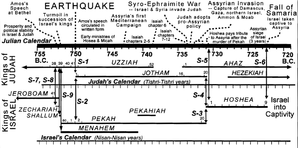 Fig. 6 - Time line showing the historical context and dating of Amos's earthquake.
Synchronisms, which are shown as vertical arrows under the time line, allow Amos's earthquake to be dated to 750 B.C.
The chronology of Hebrew kings follows Thiele (1983) with slight revisions by Finegan (1998).
Fig. 6 - Time line showing the historical context and dating of Amos's earthquake.
Synchronisms, which are shown as vertical arrows under the time line, allow Amos's earthquake to be dated to 750 B.C.
The chronology of Hebrew kings follows Thiele (1983) with slight revisions by Finegan (1998).In the second year of Pekah son of Remaliah king of Israel, Jotham son of King Uzziah of Judah began to reign)
| Date | Reference | Corrections | Notes |
|---|---|---|---|
| 750 BCE | none |
|
 from Onstott (2015)
The conclusion of regnal reckoning is as follows: the chronology of the Judges Era through the end of David's reign followed the linear, postdating system in which reign lengths were simply added together (a method currently popular in biblical scholarship). During this time, Israel's records and archives were handled by the priesthood (1 Chr 9:22; 18:16; 2 Sam 20:25). Under Solomon's administration, the linear-priestly system of reckoning chronology was abandoned in favor of the more sophisticated Egyptian antedating system, which depicted reigns more accurately. Solomon's strong ties with Egypt probably influenced this shift (1 Kings 9; see Table 9.31). This transfer probably occurred with the origin of the new document called "The Acts of Solomon" (1 Kgs 11:41), which was later inserted into the The Book of the Kings of Israel and Judah (2 Chr 16:11; see chap. 8.V.).
...
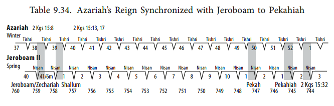
These conclusions are supported by another fact. Uzziah (Azariah), king of Judah, enjoyed one of the longest and most stable reigns in the Southern Kingdom's history. The date that Scripture provides for Uzziah allows no other conclusion for Jeroboam II's reign but the use of the linear-priestly postdating (accession-year) method. From all indications, this method continued to be employed in the Northern Kingdom until the kingdom's annihilation under Sargon and Shalmaneser V.172 Both of these systems are clarified by the scribe's synchronization of the regnal years of Judah's kings with the regnal dates of the kings of Israel (see Table 9.34).
| Location (with hotlink) | Status | Intensity | Notes |
|---|---|---|---|
| Jerusalem - Introduction | n/a | n/a | n/a |
| Jerusalem - City of David | possible to probable | ≥ 8 | Uziel and Chalaf (2021:55*) discovered
an 8th century BCE destruction layer in the earliest layer of Building 17081 in Area U where they found fallen stones above a row of smashed vessels ... along its northern wall. The fallen stones appeared to be from the upper part of the walls of the room, which had collapsed. They attributed the collapse to an earthquake. Dating was based on ceramics with one of the smashed vessels identified as Iron Age IIB - i.e. 8th century BCE. Uziel and Chalaf (2021:60*-61*) also re-interpreted destruction evidence at Area E, just south of Area U, in the City of David where they suggested that Stratum 12B contained a collapse layer likely caused by the same 8th century BCE seismic event seen in Area U. |
| En Hazeva | possible to unlikely | ≥ 6 | Tilted Gate Earthquake (?) -
 Digital Theodolite Shot of Tilted Iron Age Gate Wall at En Hatseva
Photo by Jefferson Williams 12 Jan. 2023 for nearly a couple of centuries showing no trace of later occupation activityand the immense fortress established at ‘En Hazeva over the abandoned building (Stratum VI), opens a new chapter in the site’s history, dating to the Iron Age IIB–C. Cohen and Yisrael (1995) suggested that the so-called "Middle Fortress"1 of Stratum VII was damaged by one of the Amos Quakes while Austin et al. (2000) and others have suggested that the tilted wall (see Fig. 5) in the Casemate Gate was tilted by one of these earthquakes. However, Dogon Ben-Ami (pers. communication, 2024)3 indicates that this Casemate Gate pier is in Stratum VI which dates its construction to nearly a couple of centuriesafter ~900 BCE putting it outside of the time window for the Amos Quakes - one of which struck in ~760 BCE. Although the Amos Quakes are excluded, it is possible that a later earthquake caused the tilt. However, there is a question why the other walls were not tilted. Dogon Ben-Ami (pers. communication, 2024)3 indicates that the tilted casemate pier is underlain by a layered sediment foundation like that which underlies Building 3011 (see Ben-Ami et al., 2024) while Roberts (2012:187-189) noted that floors were absent in the casemate walls. All of this points to a weak foundation which suggests an alternate theory for the wall tilt - poor construction techniques eventually led to differential settlement. In its current post excavated state, the wall  Tilted Iron Age Wall at En Hatseva
Click on image to open in a new tab where the photo can be magnified Photo by Jefferson Williams 6 Jan. 2023 Although this would seem to close the Chapter on Amos Quake evidence at En Haseva, I am going to assign an Event probability of possible to unlikely rather than unlikely simply because a final excavation report has not yet been produced, there have been changes in chronology at En Haseva as new research uncovers new evidence, and work on the site is still on-going. |
| Samaria-Sebaste | no evidence | needs investigation. There is no archaeoseismic evidence at this site for an 8th century BCE earthquake that I am aware of. | |
| Shechem | |||
| Iraq el-Amir | no evidence | needs investigation. There is no archaeoseismic evidence at this site for an 8th century BCE earthquake that I am aware of. | |
| Hazor | possible to probable | 7 | Stratum VI Earthquake - Excavations by Yigal Yadin at Hazor in the last half of the 1950s uncovered fairly compelling archaeoseismic
evidence on the south side of Area A in Stratum VI
(see, for example, Yadin et. al., 1959,
Yadin et. al., 1960,
Yadin, 1970, and/or
Yadin, 1975). The excavators encountered
tilted and collapsed walls including collapses which preserved the original courses, inclined pillars, and
fallen ceilings with extensive debris from ceiling plaster lying on floors.
Broken jars were found on the floors and some expensive luxury items were found in the debris. Stratum VI is fairly well dated. Pottery
dates it to the 8th century BCE perhaps even the first half of that century (Dever, 1992:28*
and Finkelstein, 1999:65 Table 1).
The overlying Stratum, Stratum V, is terminated by a burned destruction layer which appears to coincide with the
Assyrian destruction of Hazor in 732 BCE. Thus, it appears that Stratum VI contains a seismic destruction layer from the first half of the
8th century BCE which may coincide with one of the Amos Quakes. Although Dever (1992:28*), relying on personal communication with Amnon Ben-Tor, reports that more archaeoseismic evidence in Stratum VI was uncovered during renewed excavations in the 1990s - especially in a street and drain in Area A that seemed simply to have split down the centre — difficult to explain by any other hypothesis, Amnon Ben-Tor in Stern et al (2008) reports that indications of the destruction of stratum VI by earthquake, noted by Yadin, were not identified. A number of walls were described as tilting to the south and to the east. Ben-Menahem (1991) took this as evidence that Hazor was in the near field of seismic energy when the earthquake struck and estimated that the epicenter was only ~20 km. to the northeast. According to the report of the excavating archeologists [Yadin et. al., 1959], northern walls were tilted southward, while western walls tilted eastward. Figure 8 shows that these orientations are consistent with the effect of a near field horizontal shear acceleration coming to Hazor from the north east. This is consistent with modern ideas that structures in the near-field of a major earthquake are mostly affected by SH body waves and the fundamental Love mode. ( Ben-Menahem, 1991)While this may be correct, a true archaeoseismic survey was not conducted on the site in order to, for example, make exact measurements of tilting directions and inclinations, look for shifted ashlars, see if there were rotated stones, etc.. The fact that the damage was concentrated on the south side of Area A rather than throughout the entire site casts doubt on Ben-Menahem (1991)'s estimate of a ML = 7.3 earthquake with an epicenter a mere ~20 km. to the NE of the site. An earthquake that large and that close would have probably caused extensive damage throughout the site; not just on the south side of Area A. In addition, as noted by Korzhenkov and Mazor (1999), areas above a hypo-center do not reveal systematic inclination and collapse patterns, whereas some distance away inclination and collapse have pronounced directional patterns. Thus, while the archaeoseismic evidence does suggest that an earthquake struck the site, shaking would have been moderate rather than severe. This site may be subject to a ridge effect. |
| Megiddo | possible | ≥ 8 | Stratum IVA Earthquake (after ca. 800 BCE) - A destruction layer was found in Level H-5 of Area H which correlates to Stratum VA-IVB.
Eran Arie in Finkelstein et al. (2013 Vol. 1:270-272) reported evidence of collapse and destruction by fire while
Knauf (2002:2) reports that the occupation of Phase H5a [which correlates to Stratum IVA] was terminated by an earthquake, which cracked the city wall and strewed parts of walls of these southern buildings all over Area H. Marco et. al. (2006) observed that a staircase between the Iron II gate complex and a reservoir was tilted and faulted, a wall in the courtyard of the Southern Stables tilted to the west, there were fractures in the walls of a Silo (1404), and there were fractures in the limestone bedrock of Tunnel 1000 of the water system. Although they suggested the most likely candidate for this archaeoseismic evidence was the ~760 BCE Amos Quake, they noted that an inability to establish a terminus ante quem created chronological uncertainty and opened up the possibility that the causitive earthquake struck later. The terminus post quem was c. 800 BCE. |
| Gezer | possible | ≥ 8 | 8th century BCE Earthquake - In the vicinity of what Macalister (1912 vol.1:251)
labeled as "Tower VI" and "Tower VII", the outer city wall was variously displaced, tilted, or folded. At "Tower VI", joints traversing
adjacent ashlars and shifted ashlars were observed. Dating appears to have been assisted by a terminus ante quem due to a destruction
layer created when the Assyrians sieged the city in 733 BCE.
Younker (1991) reports that debris layers consisting of fallen ashlar blocks in a bricky fill containing 8th century BCE sherds were found above 10th century BCE fill from an excavation against the outer face of Macalister's "Tower VII". This would seem to date the apparent outer wall archaeoseismic evidence to the 8th century BCE and before 733 BCE. However, displacement and tilting is all in a downslope direction on top of a steep slope. The deformations could be due to soil creep rather than an earthquake. This site may be subject to a ridge effect. |
| Tel Ateret aka Vadun Jacob | possible | Iron Age IIA and later Earthquake(s) - 980 BCE - 142 BCE - Ellenblum et. al. (2015:6)
uncovered Iron Age IIA remains (ca. 980-830 BCE) to the south and partially beneath the Hellenistic ruins in the southern part of the site. Preliminary dating was based on
architectural style and pottery typologies.
Ellenblum et. al. (2015:6) estimated
that the Iron Age IIA wall was displaced 8 m across the fault with 6 m of displacement taking place after the early Hellenistic period. This left 2 m of displacement in an
unknown number of events during the first millennium BCE prior to the 142 BCE earthquake. |
|
| Arad | possible | ≥ 8 | Stratum XI Earthquake - 2nd half of the 9th century BCE to the 1st half of the 8th century BCE -
Herzog (2002:96-97) suggested that the ~760 BCE Amos Quake
destroyed fortifications at Arad in Stratum XI leading to the rebuilding observed in Stratum X.
Since his earthquake assignment was based on rebuilding evidence, no seismic effects
were observed but one could assume that, if
Herzog (2002)'s seismic interpretation is correct, that there would have been some collapsed walls
in Stratum XI.
Herzog (2002:94) dated Stratum XI to between the second half of the 9th century BCE and the first half of the 8th century BCE.
He used the 'low chronology' of Finkelstein and dating was based on pottery, comparison with other sites, climate change, interpretation
of socio-political developments, and architectural style.
It appears that the ~760 BCE Amos Quake was used to assign the end date of Stratum XI and
an association with Pharaoh Shishak's raid in 926 BCE and other
concomitant phenomenon was used to assign the start date. Arad was mentioned in the list of cities conquered by
Pharaoh Shishak in 926 BCE (
Herzog, 2002:92).
Singer-Avitz (2002:162) noted that there was no clear indication of the date of the establishment of Stratum Xwhich followed Stratum XI. This inferred archaeoseismic evidence is not particularly well dated. The Intensity estimate is based on an assumption of collapsed walls. |
| Lachish | possible | ≥ 8 | Level IV Earthquake (?) - ~8th century BCE (?) -
Ussishkin (2014:214) wrote that it is not at all clear why the fortified city of Lachish Level IV came to an end and Level III was built.Ussishkin (2014:214) noted changes to the the City Gate, building and rebuilding activity in domestic structures in Area S, and changes to the superstructures but not the foundations of the Palace Fort and the Southern Annex. The city walls seem to have continued in use unchanged.Level III structures were said to resemble their Level IV predecessors. Numerous broken pottery vessels found in Level IV of Area S (domestic dwellings) was thought to allude to sudden destructionbut nothing was found that would indicate that this destruction had been intentional or that an enemy had set fire to it.Moshe Kochavi, who had excavated with Yigal Yadin at Hazor in 1955 (Roberts, 2012), was said to have visited Lachish in 1976 and suggested that Level IV was destroyed by the Amos Quake ( Ussishkin, 2014:215). While Excavator David Ussishkin has reported this as a possibility, he has never mentioned it as a certainty or even a probability in a number of subsequent publications about Lachish. In addition to the mystery of what led to the destruction of Level IV, there is a chronological debate over it's date that largely stems from a lack of sufficient evidence to date it solely from material found at the site. |
| Tell es-Safi (Gath) | probable | 9 | Stratum F8A Earthquake - early to mid 8th century BCE -
Chadwick and Maeir (2018) uncovered collapsed walls of what was
a then abandoned domestic dwelling in Area F. Brick collapses were
all found to be sloping northward having shifted violently and simultaneously north off their stone foundations.They added that in some cases the lower courses of brick wall superstructures were still intact, and in one instance the flat course lines of a wall showed where its second course had sheared cleanly away from its foundation course, lying slanted over a meter north of its original line.They report that consulting engineers Oded Rabinovitch (The Technion, Israel Institute of Technology) and Amos Shiran estimated it would have taken 1 g-force of energy to move the walls off their foundations in this manner.This equates to a local Intensity of ~IX using the equation of Wald et. al. (1999). A bit below the collapse layer was Stratum F9 - dated as Iron IIA and interpreted as reflecting Philistine occupation. Above this layer two successive debris layers were found: a layer of destruction debris from the attack of Hazael (r. 842-796 BCE)'s Aramean forces, and atop that another layer of eroded brick detritus, winter rain-wash, and wind-blown soilswhich had all accumulated as the abandoned houses decayed over several decades.Collapse Layer F8A was found above this detritus and was overlain by a much thinner layer of winter rain-wash and wind-blown soilwhich in turn was covered by Judahite structures dated by ceramics to the 8th century BCE and which were probably built as early as the mid-eighth century B.C.E.and were designated as Stratum 8 which was discerned across the entire area.Because the Judahites buried the F8A earthquake collapses under new terraces and fills in Area F, the chronology of seismic destruction was preserved enabling the excavators to supply a confident date of the early to middle part of the 8th century BCE for this seismic shaking in Stratum F8A. In addition to the collapsed wall in Area F, Chadwick and Maeir (2018) report that walls collapsed by the earthquakewere also found in in Area A, on the flatter terrain of Gath's lower east side, and in Area D of the northern lower city. |
| Tell ej-Judeideh | possible | ≥ 8 | Lower Phase of Iron IIB Earthquake (?) - 8th century BCE -
Gibson (1994) re-appraised earlier excavations reported in
Bliss (1900a),
Bliss (1900b), and
Bliss and Macalister (1902). He detected two Iron IIB level building phases noting that
the structures from the lower phase were apparently destroyed (in an earthquake?) and then, in the upper phase, [] rebuilt roughly along the same lines.The pottery belonging to the lower phase did not contain the lmlk stamped handles so typical of the upper phase (Bliss 1900b:219)which led Gibson (1994) to conclude that the lower phase of the Iron IIB level at Judeideh may be the equivalent of Level IV at Lachish.Ussishkin (2014:214) mentioned the possibility that Lachish Level IV ended in destruction by the Amos Quake. According to Gibson (1994), the destroyed structures at Tell ej-Judeideh were reported in Pit 4 by Maclister where an earlier system of wallswere detected beneath the structures of the upper Iron IIB phase.Gibson (1994) also noted that Macalister pointed out that many of the stones from the lower phase walls had been re-used in the upper phase walls. lmlk stamped handles are thought to have have first been issued around 700 BCE during the reign of King Hezekiah (wikipedia). Gibson (1994) suggested that the upper phase of Iron IIB at Tell ej-Judeideh which contained lmlk stamped handles ended in destruction by Sennacherib in 701 BCE and was equivalent to Lachish Level III. |
| Tel Agol | possible | ≥ 8 | Stratum IIIB Earthquake - probably in the mid-eighth century BCE -
Feig (2021a) reports damage to casemate walls in
Stratum IIIB which she interpreted to be due to seismic shaking. She estimated the date of the damaging event to
probably in the mid-eighth century BCE.Underlying Stratum IV was dated, based on pottery, to Iron Age II - probably Iron IIA. Overlying Stratum II showed evidence of repairs to the Stratum IIIB walls. As there were no signs of destruction or devastationdue to the Assyrian conquest in 732 BCE, the excavator surmised that the settlement may have been abandoned around that time. Observed damage included collapsed, displaced, and folded walls along with broken pottery found in fallen position. |
| Deir 'Alla | possible | ≥7 | Phase M/IX Earthquakes - 8th or 9th century BCE -
Extensive archaeoseismic evidence was uncovered at Deir 'Alla in Phase M (aka Phase IX), particularly in Area B.
The mud brick walls of the damaged structures were built on top of existing surfaces, and occasionally on reed layers or wooden beams(Franken, 1976). They lacked a true foundation and the walls were only one mudbrick thick (Ibrahim and van der Kooij, 1986:135-142). They were not seismically resistant. Some of the archaeoseismic evidence looks like what one would see in a paleoseismic trench with some vertical mostly E-W cracks extending through the top of the stratigraphic layer (M/IX) and ending where other deposits began. One crack was described as being 10 cm. wide and extensional (Franken, 1976). Some of the mudbrick walls broke away at floor level while others broke above the floor but after the whole wall had shifted(Franken, 1976). Complete pottery, though often broken by the destruction of the buildings, was found in almost all of the roomsof Area B (Ibrahim and van der Kooij, 1986:138). The stratigraphically confined cracks were caused by the second earthquake as this location recorded two Phase M/IX earthquakes (Franken, 1976). The first earthquake led to a fire and, apparently, some type of abandonment ( Ibrahim and van der Kooij, 1991). The second earthquake occurred after some time, because the new surface had been used a bit( Ibrahim and van der Kooij, 1991). Franken and Ibrahim (1978:60-68) suggested that it was raining when the second earthquake struck. Dating from radiocarbon, pottery (not wheel thrown), palaeography of an inscription found in the rubble left by the second earthquake, and cultural relations (i.e. before Assyrian influence was visible) suggest an 8th or 9th century BCE date. This site in Phase M (IX) appears to have been subject to a construction related site effect due to the foundation-less one mudbrick thick buildings built on top of what Franken (1976:9) described as clay. |
| Tell el-Mazar | possible | Stratum VI Destruction on the Main Mound - 8th century CE ? -
Yassine & van der Steen (2012:81-83) saw evidence of possible
earthquake destruction in Stratum VI on the main mound.
On the main tell architecture has been found from the Assyrian period onwards.This site may be subject to a construction related site effect in this stratum due to mudbrick construction |
|
| Damiya | possible | ≥7 | Stratum VIII Destruction - 8th century BCE -
In Stratum VIII, beneath the Stratum VII in area A,
Petit & Kafafi (2019) report that remains of of an older, rectangular buildingwas discovered with wide walls made of square clay bricks. Petit & Kafafi (2020:52-54) report that although not burnt, collapse debris suggest some sort of destruction, although the team could not exclude deliberate dismantling.They also report the discovery of broken pottery - sherds of a large pithos(a storage container >1 m in diameter) found on the floor and painted with a “tree of life” and two bulls or zebus. Petit & Kafafi (2018b:35-36) report that the wall and associated finds, such as a typical Iron Age II bowl, were dated to the 8th century B.C. (Fig. 31). This site may be subject to a construction related site effect in this stratum due to mudbrick construction |
| Tell Saidiyeh | possible | Stratum VI Destruction ? - Iron IIB - mid 8th century BCE -
Tubb (1998:126) noted that towards the middle of the eighth century the houses of Stratum VI were knocked down and leveled in preparation for another major building programmein Stratum V - something that may have been a response to earthquake destruction. This site may be subject to a construction related site effect in this stratum due to mudbrick construction |
|
| Pella | possible | ≥8 | Iron IIB Earthquake (?) - ~800 BCE - Bourke (2004:13-14, 20) described a
destruction layer dated to ~800 BCE in Iron IIb at the Temple Complex in Area XXII on Tabaqat Fahl (Pella)
and throughout the area.
The remodelled Iron Age II temple precinct at Pella was in use for perhaps 150 years (ca 950–800 BC) before the temple and the entire settlement was destroyed in an extensive conflagration (Bourke et al. 2003). While earthquake activity has been suggested as the likely cause for similarly dated destruction horizons at Deir ’Alla (Franken 1992), the same horizon of destruction at nearby Tell Hammeh (Cahill et al. 1987) and Tel Rehov (Mazar 1999) has been attributed to the military activities of either Egyptian (or just possibly) Aramaean invaders. At Pella, while earthquake destruction is still considered the most probable cause, significant militaria (specifically iron arrowheads and scale armour) are consistently associated with this destruction horizon. Whatever the ultimate cause, this destruction proved to be catastrophic to the long-term well-being of the city of Pella, as settlement ceased across the site for the next 500 years, only reviving with the Seleucid occupation of the region after 200 BC (Bourke 1997)Bourke (2004:13-14, 20) discussed the destruction layer and challenges in interpreting it. Thick deposits of ash and brick debris sealed the temple proper and most nearby areas. Interpretation of the final Iron II destruction horizons is complicated by the large and intrusive Late Antique (ca 550 AD) foundation trenches that cut through much of the area, largely frustrating attempts to study the spatial patterning of objects found in situ below destruction horizons. The Iron II temple proper suffered quite severely from later constructional activity. However, the area of the eastern courtyard surrounding the central altar was largely undisturbed, and it was here that many cult objects were identified. |
| Tel Abu Hawam | possible | ≥8 | Stratum IIIB Destruction - 2nd half of the 8th century BCE or possibly even in the 7th century BCE -
During R.W. Hamilton's excavations in 1932-1933, Stratum III was found to lie between two destruction layers: a thick upper one, below stratum II, and a lower one, above part of stratum IVB. According to Hamilton, Stratum III contained more than a single phase of construction( Balensi, Herrera, and Artzy in Stern et. al., 1993 v.1). Herrera (1983) examined original documents and material finds from the 1932-1933 excavations and divided Stratum III into two phases
earlier than the latter half of the eighth century BCE( Balensi, Herrera, and Artzy in Stern et. al., 1993 v.1). This firm terminus post quem was based on the fact that the ceramic assemblages found their best parallels at Israelite, Phoenician, and Cypriot sites, mainly in the second half of the eighth century BCE (Tell el Far'ah VIID, Hazor VI-V, Samaria V-VI, and Tell Keisan 5, among other sites).It was noted, however, that the possibility of even later finds, as suggested by a seventh-century Judean cooking pot, could move the end of Stratum IIIB to an even younger date ( Balensi, Herrera, and Artzy in Stern et. al., 1993 v.1). Balensi, Herrera, and Artzy in Stern et. al., (1993 v.1) dated Stratum IIIB, before it's destruction, to the time of the Divided Monarchy. In agreement with Herrera (1983), they provided a suspiciously narrow date range of ~750-725 BCE for it's destruction. As a caveat, Balensi (1985b:66-69) noted a lack of stratigraphic homogeneity within Stratum III. The destruction event that ended Stratum IIIB is described by Balensi et. al. (1985a:95) as a burnt layer which seals Stratum III and was followed by a period of abandonment. Hamilton (1935:6) described the destruction layer as ashes and mixed debris which, though tenuous or non-existent at the edges [of the Tel], were thick and well defined at the centre of the site. The cause of this destruction is unknown. It could have been due to human agency. |
| Tel Rehov | possible | ≥8 | Stratum IV Destruction - Late Iron IIA - ~9th-8th century BCE - According to
Panitz-Cohen and Mazar in Mazar et. al. (2020 v.2:186),
Stratum C-1a [equivalent to Stratum IV] came to an end in a sudden violent destruction that involved a fierce conflagration, evidenced in each of the excavated buildings revealed just below topsoil.Temperatures were thought to exceed 500°C, since it caused partial firing of the brick courses and the mud plaster in many of the walls.In several cases, they report that pottery vessels cracked and became distorted, with much calcification. As an example, they noted that the large pottery crate in Building CF was so distorted by the fire that it was extremely difficult to restore. According to Panitz-Cohen and Mazar in Mazar et. al. (2020 v.2:186), the destruction was sudden, based on the incredible quantity of pottery vessels and other objects found in the houses. Only one skeleton was found which might suggest an earthquake which struck during the daytime. No activity on the site was detected after the Stratum IV (C-1a) destruction except for one deep pit (6498 in Square Y/6) which cut through most of the Iron IIA strata, and possibly, a gray fill, devoid of finds, in Square Z/1 above part of Building CL.The site appears to have been abandoned after the earthquake. Archaeoseismic evidence in Area C, the best studied location, is fairly extensive and includes collapsed and tilted walls, fallen ceilings, broken pottery (some apparently found in fallen position), and debris. There also appears to be archaeoseismic evidence for this event in Areas D, E, and G. Unlike the Stratum V and VI earthquakes, there is no compelling or obvious evidence of vertical shaking during this event indicating that Tel Rehov probably was not in the hypocentral region and the active faults underlying the site probably did not slip. Dating was based on ceramic evidence and radiocarbon. Although Panitz-Cohen and Mazar in Mazar et. al. (2020 v.2) dated this Iron IIA event to the 9th century and no later than 840/830 BCE, Finkelstein and Piasetzky (2010:Table 2) and Finkelstein (2013: 7-8, Table 1, 83; 2017: 186) date the end of Late Iron IIA to ~760 BCE - which coincides with the approximate date of the Amos Quake. In the Tel Rehov Paleoseismic Trench, ~300 m north of Tel Rehov, Zilberman et. al. (2004) identified an Event (I) with 1.2+ meters of slip which they suggested was caused by the ~760 BCE Amos Quake (despite the fact that they dated Event I to the 7th century BCE in their report). Thus, it seems prudent to consider that the Stratum IV destruction could have been one and the same with the ~760 BCE Amos Quake. The dating range for this Stratum IV event has therefore been expanded out to include the 8th century BCE. The damaged structures were made entirely of mudbricks with wood beam foundations so there is likely a construction related site affect for all the Iron Age II structures. |
| Dan | no evidence | End of Stratum III - Iron Age II - No reported earthquake evidence - Although
Alanne (2017) lists an Earthquake between Strata III and II in the 9th or 8th century BCE in Table 1
(Stratigraphy), this appears to be based on
Yadin's excavations at nearby Hazor
where he interpreted archaeoseismic evidence on the south side of Area A in Hazor Stratum VI due to the
~760 BCE Amos Quake.
Alanne (2017:46) noted that Strata III and II show a progressive development without any traces of destruction layerswhile Stratum II (dated by Biran to the 8th century) faced quite a sudden destruction, most probably caused by the Assyrian attack around 732 BCE. |
|
| Location (with hotlink) | Status | Intensity | Notes |
| Location (with hotlink) | Status | Minimum PGA (g) | Likely PGA (g) | Likely Intensity1 | Comments |
|---|---|---|---|---|---|
| Jordan River Delta | possible | Niemi and Ben-Avraham (1994) estimated that Event 2 was younger than 3-5 ka and older than 1927 CE. | |||
| Jerusalem Landslides | |||||
| Location (with hotlink) | Status | Minimum PGA (g) | Likely PGA (g) | Likely Intensity1 | Comments |
| Location (with hotlink) | Status | Intensity | Notes |
|---|---|---|---|
| Hacipasa Trenches | possible to unlikely | ≥ 7 | The oldest event identified in the Ziyaret Trench dated to before 983 CE. A lower bound on age was not available due to insufficient radiocarbon dates. |
| Kazzab Trench | possible | ≥ 7 | Daeron et al (2007)
dated events S4, ?S5, and ?S6 to between 2115 and 6288 years B.P. These appear to be in Sequence 2 for which the age-depth functionis unknown and a hiatus was suspected. |
| Jarmaq Trench | possible | ≥ 7 | Nemer and Meghraoui (2006) date Event Y to between 2920-2879 BCE and 84-239 CE. |
| al-Harif Aqueduct | possible | ≥ 7 | Sbeinati et al (2010)
dated Event W, characterized from paleoseismology (Trench C only), to between 3400-3000 BCE and 800-510 BCE and speculated that it may have been caused by the ~1365 BCE
earthquake which, they claim, affected Ugharit near Latakia in Northern Syria and Tyre in Southern Lebanon or another earthquake. They noted that
the rate of sedimentation in unit f of trench C implies a minimum age of 962 B.C. for event Wand estimated ~4.6 m of slip. |
| Qiryat-Shemona Rockfalls | possible | Kanari, M. (2008) examined rockfalls in Qiryat-Shemona which were attributed to earthquakes. Optically stimulated luminescence (OSL) dating was performed on soil samples beneath the fallen rocks. Sample ID QS-13 was dated to 3.2 +/- 0.45 ka BP which makes one of the Amos Quakes a possible candidate (Kanari, 2008). | |
| Bet Zayda | no evidence | ≥ 7 | Earthquakes before 392 BCE were not observed by Wechsler et al (2014) or Wechsler et al (2018) however Tom Rockwell (personal correspondence, 2022) indicates that several unstudied southern channels in the area could have captured older events such as one of the Amos Quakes. |
| Jordan Valley - Tel Rehov Trench | possible | Zilberman et al (2004) dated Event I to the 7th century BCE and Event II to the 6th century BCE. Based on displacements, they estimated a Magnitude of 6.5-6.6 for Event I and 6.6-6.7 for Event II. | |
| Jordan Valley - Tell Saidiyeh and Ghor Kabed Trenches | no evidence | ≥ 7 | Ferry et al (2011) detected 12 surface rupturing seismic events in 4 trenches (T1-T4) in Tell Saidiyeh and Ghor Kabed; 10 of which were prehistoric. They did not identify any paleoseismic events matching with the Amos Quakes and cited archaeoseismic evidence from other studies in Deir 'Alla (Franken, 1989:204) and Tell Saidiyeh (Tubb, 1988:126-127, 130) for an earthquake from around this time. |
| Dead Sea - Seismite Types | n/a | n/a | n/a |
| Dead Sea - En Feshka | probable | 8 - 8.8 (both seismites) | Two seismites are candidates (Kagan et al, 2011)
|
| Dead Sea - Nahal Darga | possible to probable | ≥ 7 | Enzel et. al. (2000) identified a 150 cm. thick seismite in coarse grained lithology in Deformed Unit 7 in Stratigraphic Unit 9 which dated to ~750 BCE +/- 300 (~ 3000-2400 yrs BP). |
| Dead Sea - En Gedi | possible | 8 - 8.9 (both seismites) | Two possible seismites from the En Gedi Core
(
Migowski et. al., 2004)
|
| Dead Sea - Nahal Ze 'elim | probable | 8 - 9 (both seismites) | Two possible seismites from Kagan et al (2011) at ZA-2.
Jefferson Williams observed similar seismites in the East section of site ZA-4 above the Late Bronze Beach Ridge at (floating) depths of 577 cm. (8 cm. thick) and 616 cm. (6-8 cm.thick). |
| Araba - Introduction | n/a | n/a | n/a |
| Araba - Taybeh Trench | possible to probable | ≥ 7 | Event E8 in the Taybeh Trench (LeFevre et al., 2018) was dated to 700 BCE +/- 186 and matches well with a ~750 BCE date for the Southern Amos Quake. |
| Araba - Qatar Trench | unlikely | ≥ 7 | Klinger et. al. (2015) did not identify any events in the Qatar Trench which correlate with either of the Amos Quakes. |
| Araba - Taba Sabhka Trench | unlikely | ≥ 7 | None of the events in the Taba Sabhka Trench correlate with an earthquake around the time of the Amos Quakes (Allison, 2013). |
| Araba - Shehoret, Roded, and Avrona Alluvial Fan Trenches | possible | ≥ 7 | Event 5, with 0.2 m of displacement, dated to 500 BCE +/- 1000 (1500 BCE - 500 CE). |
| Location (with hotlink) | Status | Intensity | Notes |
Table 1 Earthquake damage around the DST during Bronze and Iron Ages


Raphael, Kate and Agnon, Amotz (2018). EARTHQUAKES EAST AND WEST OF THE DEAD SEA TRANSFORM IN THE BRONZE AND IRON AGES.
Tell it in Gath Studies in the History and Archaeology of Israel Essays in Honor of Aren M. Maeir on the Occasion of his Sixtieth Birthday
J. R. C. Itzhaq Shai, Louise Hitchcock, Amit Dagan, Chris McKinny, and Joe Uziel.
2. Biblical Evidence for the Earthquake Mentioned in Amos
Physical phenomena related to earthquakes include loud noises, ground shaking, ground displacement, landslide, liquefaction of unstable soils,
sand blows from the ground, damage to or collapse of units of the human constructed environment, fire, changes of water courses, and tsunami.
Forty possible references exist to almost all of these throughout the Book of Amos, excluding only sand blows and changes of water courses
(see Table 1). Of these forty, ten are quite certain. The distribution of such references throughout the book clearly indicates the high degree of impact
that at least one earthquake had upon Amos and the people of Israel. Earthquake-related destruction is one of the major types of looming destructive forces
that Amos proclaims will befall the Israelites. When taken in aggregate including all of the possible resultant phenomena, earthquake-related destructive
threats are the most numerous among the threats in Amos. The prominence of earthquake references and allusions substantiates the notion that the earthquake
in Amos's time is what solidified his prophecies as true via what must have been seen, at least in part, as their fulfillment. Some scholars have gone as
far as designating this turn of events as a major causative factor in the onset of classical Israelite prophecy in the form of non-professional, morally sensitive,
exhortatory prophets whose visions and admonitions were written down as non-narrative, literary works.
There are several types of references to earthquakes and earthquake-related phenomena in Amos. Most straightforward are explicit references to actual events,
which is found only in the superscription to the book (Amos 1:1). Other references in are found in the types of literature common to the book, mostly visions and
oracles. In those, there are allusions to impending disastrous events and descriptions of God's power over nature, as well as to God's walking and
presence, which may cause catastrophes. All of these types of allusions are used in multiple ways in connection with earthquakes and earthquake-related events.
...
The explicit references in Amos to the earthquake at his time are found in 1:1 and 9:1. The former, the superscription to the book, or at least its first group of
prophecies, locates the earthquake in time as [] two years before the earthquake. It also places Amos' mission in the days of Uzziah and Jereboam II,
which substantiates the equation of Amos' earthquake with that mentioned in Zechariah
14:4-5 that is said to have occurred in the days of Uzziah. Isaiah may also refer to that same earthquake in 2:10-21 and 6:4.
Amos 9:1 describes an interactive prophetic vision:
[] I saw my Lord standing by the altar, and He said: Strike the capitals so that the thresholds quake, and make an end of the first of them all.God instructs Amos to strike the capitals of the columns of the doorway to a temple in which Amos beholds Him standing atop or beside the altar. This will then shake the pillars of the doorway, which will tumble down on the people. Seemingly, this will initiate an earthquake. Even though this is not stated as historical fact, it still might indicate that the epicenter, the central surface location of an earthquake that corresponds to its underground focus, was near this temple. It is unclear to what temple the text refers. The only specific temple environs referred to in Amos are that of Bet El in the vignette of Amos and the priest Amaziah (7:10-17). As such, it is the most likely location for this story, although it may be in the temple in Jerusalem in Amos' homeland, or in another temple.
[] 4 On that day, He will set His feet on the Mount of Olives, near Jerusalem on the east; and the Mount of Olives shall split across from east to west, and one part of the Mount shall shift to the north and the other to the south, a huge gorge. 5 And the Valley in the Hills shall be stopped up, for the Valley of the Hills shall reach only to Azal; it shall be stopped up as it was stopped up as a result of the earthquake in the days of King Uzziah of Judah. And the Lord my God, with all the holy beings, will come to you.This passage describes some type of ground movements, either faulting, or, more probably, major landslides, which significantly changed the landscape east of Jerusalem. The first verse seems to describe the disintegration of the central part of the mountain, leaving two sister mountains, side-by-side. The second seems to refer to the damming up of the valley, either the new one between the mountains or the one between the Mount of Olives and the temple mount. However, it is very unclear as to how much of this description refers to the earthquake in the days of Uzziah. If one reads the word [] in accordance with the Massoretic Pointing as you escape(d), then the whole description seems to be of something similar to the earthquake in the days of Uzziah. But, if one understands [] as was closed up, then it seems that only the closing up of the valley is what was similar to that of the days of Uzziah. In either reading, it seems to imply that the earthquake in the days of Uzziah affected Jerusalem, although even that could be questioned.
[] And all of it swells like the Nile and subsides like the Nile of Egypt (8:8, 9:5).The image of the rise and fall of the Nile as applied by these verses to [] forms a double entendre, indicating both the ground movements of an earthquake and the water movements of a tsunami. Another phrase that is doubled in Amos, which directly describes God as creating a tsunami, reads,
[] Who summons the waters of the sea and pours them over the land (5:8, 9:6).It seems that the phrases in 8:8 and 5:8 were copied from the earlier locations in Amos and collated in Amos 9:5-6, possibly as an expansion on Amos' vision of the striking of the capitals in 9:1. If so, the collator definitely understood 9:1 as describing the divine onset of the earthquake. Tsunamis reach the Levantine shores of the Mediterranean due to either earthquakes from the underwater subduction zone arcing south of Cyprus or from farther afield, such as offshore Greece or Italy, or to nearby underwater slumps or avalanches caused by seismic shaking from the Dead Sea Transform.
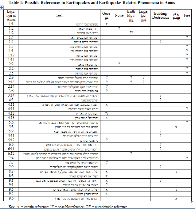 Table 1 - Danzig (2011)

 Chronology of the Hebrew Kings according to Thiele


