En Haseva
 Orthophoto of En Haseva
Click on Image to open a high resolution magnifiable image in a new tab
From Drone Survey by Jefferson Williams 12 Jan. 2023
| Transliterated Name | Source | Name |
|---|---|---|
| En Haseva | Hebrew | עין חצבה |
| Mezadit Hazeva (or Mezad Haseva) | Hebrew | מצודת חצבה |
| Ain Husub | Arabic | عين هسوب |
| Hosob | German (Musil) | |
| Tamara | Latin | |
| Thamana | Latin | |
| Thamaro | Greek/Latin form | Θαμαρώ |
| Tamar | Biblical Hebrew | תָּמָר |
- Location Map from
biblewalks.com
 Map of the area – during the Biblical periods
En Haseva is labeled as Tamar
(based on Bible Mapper 3.0)
Used with permission from BibleWalks.com - Location Map from
Cohen and Yisrael (1995)
 'En Haseva sits at a stratgeically crucial commercial crossroads, especially vital for the Arabian spice trade
Cohen and Yisrael (1995) - Map of the main Iron
Age sites in the Negev Hills (En Haseva not included) from Stern et al (1993 v. 3)
 Map of the main Iron Age sites in the Negev Hills
En Haseva not included
Stern et. al. (1993 v. 3)
- Annotated Satellite Image (google) of
En Haseva from biblewalks.com
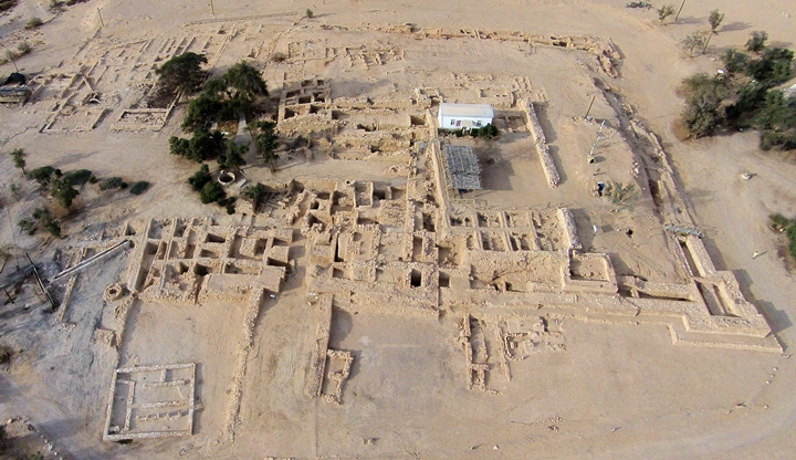
- Oblique Aerial Shot of Entire Site
by Jefferson Williams
 Oblique Aerial Shot of entire excavated site of En Hatseva
Photo by Jefferson Williams 12 Jan. 2023 - Oblique Aerial Shot of Entire Site
(cropped) by Jefferson Williams
 Cropped Oblique Aerial Shot of entire excavated site of En Hatseva
Photo by Jefferson Williams 12 Jan. 2023 - Aerial View of En Haseva
from biblewalks.com
 Aerial View of En Haseva
Click on Image for high resolution magnifiable image
Used with permission from BibleWalks.com - Outline of early Israelite
fortress in En Haseva from biblewalks.com
- Outline of Roman
fortress, bathhouse, and Inn in En Haseva from biblewalks.com
- Fig. 1.83 - Aerial Photo of
site from Erickson-Gini (2010)
 Figure 1.83
‘En Hazeva, 1990-1994 excavations (Note revised plan of the cavalry camp in Fig. 1.58)
Erickson-Gini (2010) - Oblique Aerial Shot of Iron Age
Gate by Jefferson Williams
 Oblique Aerial Shot of Iron Age Gate at En Hatseva
Photo by Jefferson Williams 6 Jan. 2023 - Fig. 11 - Aerial photo
of Area E from Erickson-Gini and Moore Bekes (2019)
 Figure 11
Aerial photo of Area E prior to balk removal, looking northwest
Erickson-Gini and Moore Bekes (2019) - En Haseva in Google Earth
 En Haseva
click on image to explore this site on a new tab in Google Earth - En Haseva on govmap.gov.il
 En Haseva
click on image to explore this site on a new tab in govmap.gov.il


Orthophoto of En HasevaClick on Image to open a high resolution magnifiable image in a new tab
From Drone Survey by Jefferson Williams 12 Jan. 2023
- Fig. 1.83 - Aerial Photo of
site from Erickson-Gini (2010)
Figure 1.83
‘En Hazeva, 1990-1994 excavations (Note revised plan of the cavalry camp in Fig. 1.58)
Erickson-Gini (2010) - Fig. 1.83 - Site plan from
from Erickson-Gini (2010)
 Figure 1.83
‘En Hazeva, 1990-1994 excavations (Note revised plan of the cavalry camp in Fig. 1.58)
Erickson-Gini (2010) - Site plan with Cohen's
original stratigraphy (in Hebrew where שִׁכבָה = Stratum) from Cohen and Israel (1990)
 Site plan with Cohen's original stratigraphy (in Hebrew)
שִׁכבָה = Stratum
Cohen and Israel (1990)
- Fig. 1.83 - Aerial Photo of
site from Erickson-Gini (2010)
Figure 1.83
‘En Hazeva, 1990-1994 excavations (Note revised plan of the cavalry camp in Fig. 1.58)
Erickson-Gini (2010) - Fig. 1.83 - Site plan from
from Erickson-Gini (2010)
Figure 1.83
‘En Hazeva, 1990-1994 excavations (Note revised plan of the cavalry camp in Fig. 1.58)
Erickson-Gini (2010) - Site plan with Cohen's
original stratigraphy (in Hebrew where שִׁכבָה = Stratum) from Cohen and Israel (1990)
Site plan with Cohen's original stratigraphy (in Hebrew)
שִׁכבָה = Stratum
Cohen and Israel (1990)
- Plan of fortresses at En Haseva
from Stern et al (1993 v. 2)
 Mezad Hazeva: plan of the Roman fortress and the two Iron Age fortresses
Stern et. al. (1993) - Fig. 1.84 - Plan of Late
Roman Fort from Erickson-Gini (2010)
 Figure 1.84
‘En Hazeva Late Roman Fort
Erickson-Gini (2010) - Artist's depiction of the
Middle Fortress at En Haseva from Cohen and Yisrael (1995)
 The middle fortress (Stratum 5) from the ninth-eighth centuries BCE occupies roughly four times the areal extent
of contemporaneous Negev fortresses. Perhaps the site should be regarded as a small administrative city, like the Judean
fortified city of Tel Beersheba, rather than a large fortress. Courtesy of the Israel Antiquities Authority.
The middle fortress (Stratum 5) from the ninth-eighth centuries BCE occupies roughly four times the areal extent
of contemporaneous Negev fortresses. Perhaps the site should be regarded as a small administrative city, like the Judean
fortified city of Tel Beersheba, rather than a large fortress. Courtesy of the Israel Antiquities Authority.
Cohen and Yisrael (1995)
- Plan of fortresses
at En Haseva from Stern et al (1993 v. 2)
Mezad Hazeva: plan of the Roman fortress and the two Iron Age fortresses
Stern et. al. (1993) - Fig. 1.84 - Plan of Late
Roman Fort from Erickson-Gini (2010)
Figure 1.84
‘En Hazeva Late Roman Fort
Erickson-Gini (2010) - Artist's depiction of the
Middle Fortress at En Haseva from Cohen and Yisrael (1995)
The middle fortress (Stratum 5) from the ninth-eighth centuries BCE occupies roughly four times the areal extent
of contemporaneous Negev fortresses. Perhaps the site should be regarded as a small administrative city, like the Judean
fortified city of Tel Beersheba, rather than a large fortress. Courtesy of the Israel Antiquities Authority.
Cohen and Yisrael (1995)
- Fig. 4 - Plan of the eastern
part of the Roman camp from Erickson-Gini and Moore Bekes (2019)
 Figure 4
The eastern part of the camp, plan
JW: locations
Room 45 - upper right
Wall 785 - mid right
Room 53 - bottom center
Wall W578 - bottom right
Erickson-Gini and Moore Bekes (2019) - Fig. 1.58 - Plan of Late
Roman cavalry camp from Erickson-Gini (2010)
 Figure 1.58
Late Roman cavalry camp, ‘En Hazeva
Erickson-Gini (2010) - Fig. 1.59 - Cavalry camp
treasury vault sections (before and after Late Roman or Byzantine Earthquake from Erickson-Gini (2010)
 Figure 1.59
'En Hazeva cavalry camp treasury vault sections
Erickson-Gini (2010) - Fig. 9 - Plan and sections
of Room 53 from Erickson-Gini and Moore Bekes (2019)
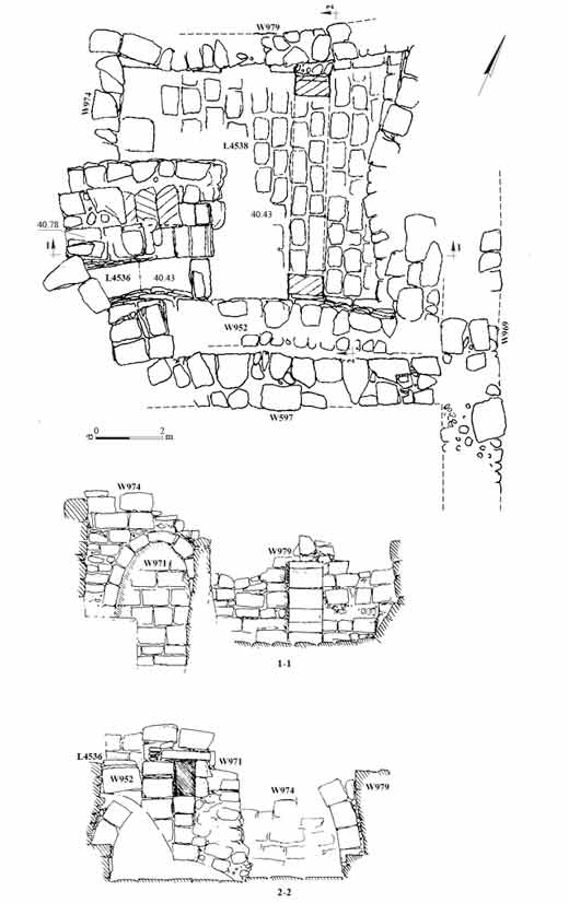 Figure 9
Room 53, plan and sections
Erickson-Gini and Moore Bekes (2019)
- Fig. 4 - Plan of the eastern
part of the Roman camp from Erickson-Gini and Moore Bekes (2019)
Figure 4
The eastern part of the camp, plan
JW: locations
Room 45 - upper right
Wall 785 - mid right
Room 53 - bottom center
Wall W578 - bottom right
Erickson-Gini and Moore Bekes (2019) - Fig. 1.58 - Plan of Late
Roman cavalry camp from Erickson-Gini (2010)
Figure 1.58
Late Roman cavalry camp, ‘En Hazeva
Erickson-Gini (2010) - Fig. 1.59 - Cavalry camp
treasury vault sections (before and after Late Roman or Byzantine Earthquake from Erickson-Gini (2010)
Figure 1.59
'En Hazeva cavalry camp treasury vault sections
Erickson-Gini (2010) - Fig. 9 - Plan and sections
of Room 53 from Erickson-Gini and Moore Bekes (2019)
Figure 9
Room 53, plan and sections
Erickson-Gini and Moore Bekes (2019)
 Figure 2
Plan of ‘En Hazeva, Phase VIIB
(drawn by D. Poretzki, Israel Antiquities Authority)
Ben-Ami et al. (2024)
Figure 3Plan of ‘En Hazeva, Phase VIIA
(drawn by D. Poretzki, Israel Antiquities Authority)
Ben-Ami et al. (2024)
 Figure 2
Plan of ‘En Hazeva, Phase VIIB
(drawn by D. Poretzki, Israel Antiquities Authority)
Ben-Ami et al. (2024)
 Figure 3
Plan of ‘En Hazeva, Phase VIIA
(drawn by D. Poretzki, Israel Antiquities Authority)
Ben-Ami et al. (2024)
 Table 1
Radiocarbon measurements, their archaeological contexts, and calibrated ranges without modelling. The δ13C was measured in the AMS
Ben-Ami et al. (2024)
 Figure 15
Modelled probability distributions of ‘En Hazeva, based on stratigraphic model. The agreement of the model is 69%. The modelled distribution is marked with dark grey or colour, while the borders and highly transparent colouring mark the entire unmodelled probability distribution. The upper line below the distributions is the 68.3% range, and the lower line is the 95.4% probability
Ben-Ami et al. (2024)
 Figure 16
Calibrated probability distributions on the Calibration Curve. The modelled distribution is marked with grey or colour, while the borders and highly transparent colouring mark the entire unmodelled probability distribution. The lines below the distributions mark the 68.3% range. The sample in red (RTD-12153) is stratigraphically the earliest sample at the site and falls at a low part of the wiggle around 960 BC. The two samples in green were taken from Phases VIIB and VIIA in situ contexts. Sample RTD 12207 comes from the latest use of Building 3011
Ben-Ami et al. (2024)
 Figure 17
Separate sums of all the probability distributions of the radiocarbon dates published from ‘En Hazeva, Khirbet en- Nahas and Atar Haroa. The number of samples used for each sum-plot appears next to the site names. The dark grey area in the ‘En Hazeva plot denotes the modelled date range of the site.
Ben-Ami et al. (2024)
- Fig. 14 - Wall 578 and
the eastern wall of the gatehouse (W595) from Erickson-Gini and Moore Bekes (2019)
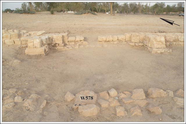 Figure 14
Wall 578 and the eastern wall of the gatehouse (W595), looking east.
Erickson-Gini and Moore Bekes (2019) - Fig. 1.85 - Restored
finds from 363 CE destruction layer in casemate rooms in Late Roman fort at ‘En Hazeva from Erickson-Gini (2010)
 Figure 1.85
Restored finds from the 363 CE destruction layer in the casemate rooms in the Late Roman fort at ‘En Hazeva
Erickson-Gini (2010) - Fig. 1.85 - Restored
finds from 363 CE destruction layer in casemate rooms in Late Roman fort at ‘En Hazeva from Erickson-Gini (2010)
 Figure 1.85
Restored finds from the 363 CE destruction layer in the casemate rooms in the Late Roman fort at ‘En Hazeva
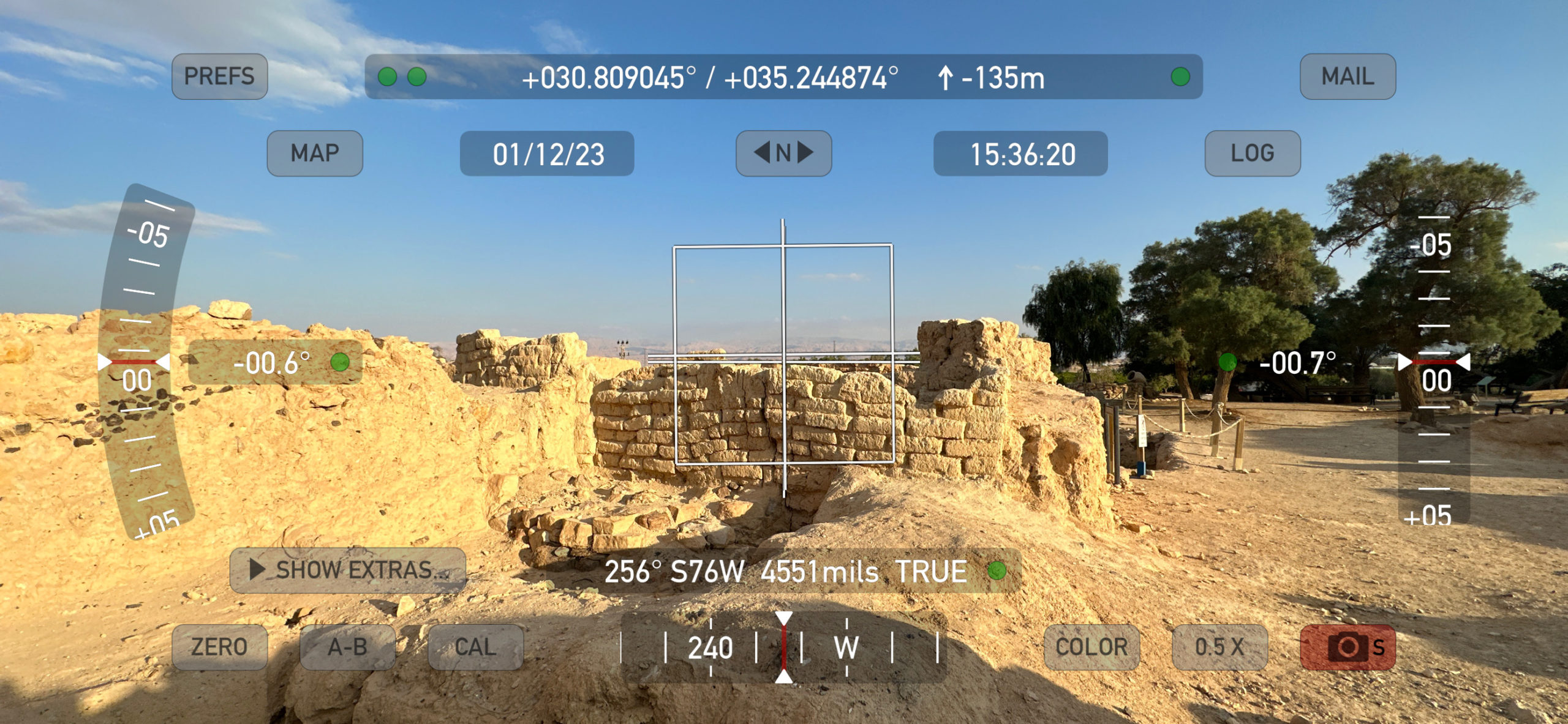
Erickson-Gini (2010) - Digital Theodolite photo
of the Iron Age Gate's Tilted Wall - photo by JW
 Digital Theodolite Shot of Tilted Iron Age Gate Wall at En Hatseva
Photo by Jefferson Williams 12 Jan. 2023 - Fig. 4 - Constructional
fills below Room 4’s floor from Ben-Ami et al. (2024)
 Figure 4
Constructional fills below Room 4’s floor, looking west. Note there is no foundation trench for W330 on the left
(photograph by A. Peretz, Israel Antiquities Authority)
Ben-Ami et al. (2024) - Fig. 5 - Constructional
fills diagonally slanting from the outer face of Wall W340 from Ben-Ami et al. (2024)
 Figure 5
Constructional fills diagonally slanting from the outer face of W340, looking south. The connection between the wall and the fills was cut in modern times
(photograph by A. Peretz, Israel Antiquities Authority)
Ben-Ami et al. (2024) - Fig. 6 - Constructional
fills diagonally slanting from the outer face of Wall W871 from Ben-Ami et al. (2024)
 Figure 6
Constructional fills diagonally slanting from the outer face of W871, looking west
(photograph by A. Peretz, Israel Antiquities Authority)
Ben-Ami et al. (2024) - Fig. 7 - General view
of Building 3011 from Ben-Ami et al. (2024)
 Figure 7
General view of Building 3011, looking north-west. At the rear, Stratum VI mudbrick installation L3137
(photograph by A. Peretz, Israel Antiquities Authority)
Ben-Ami et al. (2024) - Fig. 9 - Building 3011
from Ben-Ami et al. (2024)
 Figure 9
Building 3011, looking north-west; the location of the dated samples marked
(photograph by A. Peretz, Israel Antiquities Authority)
Ben-Ami et al. (2024) - Fig. 11 - Black surface
L131 extending under Building 3011’s southern foundation wall (W871) from Ben-Ami et al. (2024)
 Figure 11
Black surface L131 extending under Building 3011’s southern foundation wall (W871); the location of dated sample RDT 12153 marked. Looking north
(photograph by A. Peretz, Israel Antiquities Authority)
Ben-Ami et al. (2024) - Fig. 12 - Wall W132
(St. VIII) and two related floors — L132 and L134 from Ben-Ami et al. (2024)
 Figure 12
W132 (St. VIII) and two related floors — L132 and L134, looking south-east; showing the location of dated sample RDT 12152
(photograph by J. Regev)
Ben-Ami et al. (2024) - Fig. 13 - Mudbrick superstructure
wall (W855) atop a stone foundation from Ben-Ami et al. (2024)
 Figure 13
Mudbrick superstructure wall (W855) atop a stone foundation showing the location of dated sample RDT 12155, looking east
(photograph by A. Peretz, Israel Antiquities Authority)
Ben-Ami et al. (2024) - Fig. 14 - Floor 130 (Phase VIIB; Room 3)
with circular deposit of dark heat-altered sediments (L129) from Ben-Ami et al. (2024)
 Figure 14
Floor 130 (Phase VIIB; Room 3) with circular deposit of dark heat-altered sediments (L129), looking north-west; showing the location of dated sample RDT 12154
(photograph by A. Peretz, Israel Antiquities Authority)
Ben-Ami et al. (2024)
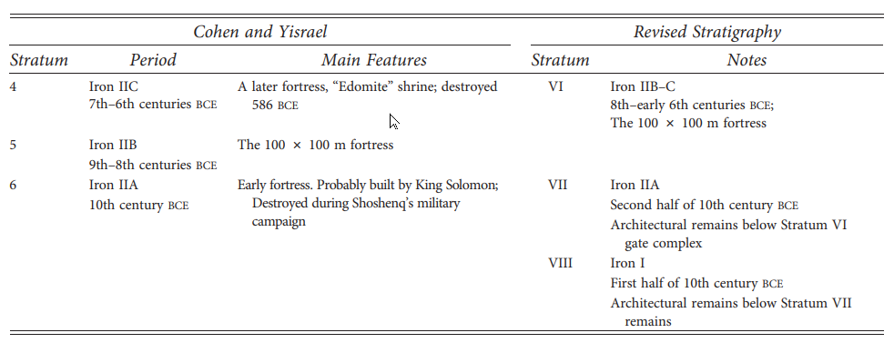 Table 3
The Iron Age Strata at ʿEn Hazeva ̣ – Revised Stratigraphical Sequence Presented in This Article
click on image to open in a new tab
Ben-Ami et al. (2026)
- Artist's depiction of the
Middle Fortress at En Haseva from Cohen and Yisrael (1995)
The middle fortress (Stratum 5) from the ninth-eighth centuries BCE occupies roughly four times the areal extent
of contemporaneous Negev fortresses. Perhaps the site should be regarded as a small administrative city, like the Judean
fortified city of Tel Beersheba, rather than a large fortress. Courtesy of the Israel Antiquities Authority.
Cohen and Yisrael (1995) - Fig. 5 The tilted Iron Age
wall of En Haseva from Austin et al (2000)
 Figure 5
Foundation failure beneath the inside pier of the fortress gate at `En Haseva. Although the Iron Age fortress gate is superbly constructed of well-hewn stones, individual blocks within the pier cracked on several courses as the foundation compacted differentially. The whole pier of the gate now leans northeastward. The excavators of the gate complex associated destruction debris within the gate complex to damage caused by an earthquake, not foundation failure caused by a continuous process of creep.
Austin et al (2000) - Photo of Tilted Iron Age Gate
Wall by Jefferson Williams
 Tilted Iron Age Wall at En Hatseva
Click on image to open in a new tab where the photo can be magnified
Photo by Jefferson Williams 6 Jan. 2023 - Digital Theodolite photo
of the Iron Age Gate's Tilted Wall - photo by Jefferson Williams
Digital Theodolite Shot of Tilted Iron Age Gate Wall at En Hatseva
Photo by Jefferson Williams 12 Jan. 2023
Ben-Ami et al. (2024)
used radiocarbon to produce an absolute chronology for the so-called "Early Fortress"1 of Strata VIII and the
so-called "Middle Fortress"1 of Stratum VII. Stratum VIII was dated ending in ~950 BCE while both phases of Stratum VII (A and B) were dated to between
~950 and ~900 BCE.
Ben-Ami et al. (2024)
assigned Stratum VIII to Iron Age I and both phases of Stratum VII to Iron Age IIA - which appears to follow Finklestein's Low Chronology2.
The date ranges of
Ben-Ami et al. (2024)
were supplemented with pottery, cross-checked with radiocarbon dates from nearby sites, compared to architectural styles of the time, and assessed in regards to historical trends in the region.
Ben-Ami et al. (2024)
contend that during the Early Iron Age IIA (Stratum VII), 'En Haseva was associated or involved with copper trade from the nearby copper mining and production site of Khirbet en-Nahas in Wadi Faynan.
They also concluded that abandonment at the end of Stratum VII in ~900 BCE was not due to Egyptian Pharaoh's Shoshenq I's ~925 BCE military campaign in Southern Canaan.
Post Stratum VII abandonment, according to
Ben-Ami et al. (2024),
lasted for nearly a couple of centuries showing no trace of later occupation activity
and the immense fortress established at ‘En Hazeva over the abandoned building (Stratum VI),
opens a new chapter in the site’s history, dating to the Iron Age IIB–C
.
Cohen and Yisrael (1995) suggested that the so-called "Middle Fortress"1 of Stratum VII was damaged by one of the
Amos Quakes while
Austin et al. (2000) and others
have suggested that the tilted wall (see Fig. 5) in the Casemate Gate was tilted by one of these earthquakes. However, Dogon Ben-Ami (pers. communication, 2024)3 indicates that
this Casemate Gate pier is in Stratum VI which dates its construction to nearly a couple of centuries
after ~900 BCE putting it outside of the time window for the
Amos Quakes - one of which struck in ~760 BCE.
Although the Amos Quakes are excluded, it is possible that a later earthquake caused the tilt.
However, there is a question why the other walls were not tilted. Dogon Ben-Ami (pers. communication, 2024)3 indicates that the tilted casemate pier is underlain by
a layered sediment foundation like that which underlies Building 3011
(see Ben-Ami et al., 2024)
while Roberts (2012:187-189) noted that floors were absent in the casemate walls. All of this points to a weak foundation which suggests an
alternate theory for the wall tilt - poor construction techniques eventually led to differential settlement.
In its current post excavated state, the wall
Tilted Iron Age Wall at En HatsevaClick on image to open in a new tab where the photo can be magnified
Photo by Jefferson Williams 6 Jan. 2023
Although this would seem to close the Chapter on Amos Quake evidence at En Haseva, I am going to assign an Event probability of possible to unlikely rather than unlikely simply because a final excavation report has not yet been produced, there have been changes in chronology at En Haseva as new research uncovers new evidence, and work on the site is still on-going.
21. 'Haseva
‘En Haseva (Tamar) stood as a massive 100m x 100m Iron Age fortress (or fortified city) on the southern border of ancient Judah about 35 km south of the Dead Sea. While excavation began in the early 1970’s, it was only in 1987 that the excavations, directed by Rudolph Cohen and Yigal Yisrael, uncovered an Iron Age fortress.135 In Cohen’s 1993 article that updated the discovery of the Iron Age fortress, he also noted that the end of strata 2, the Late Roman Period (third-fourth century CE) could have been due to the earthquake of 363 CE though he did not supply any evidence for his suggestion.136 While early on, there was very little pottery to help date the Iron Age strata, more discoveries helped excavators conclude that Stratum 5 was built in the ninth-eighth century rather than a century later as they previously thought. towers at the corners and an offset-inset casemate wall built of dressed stones. These walls surround a large courtyard with a four-room gate near the northeastern corner of the fortress with some storehouses and granaries near an inner courtyard surrounded by casemate walls. An interesting feature of the site is the absence of floors. In both the storehouses and in the casemate walls floors are absent and complete vessels were found in only two of the casemate rooms near the gate and in the granaries.
Regarding the end of Stratum V, the excavators suggest an earthquake, “Based on the destruction debris and its configuration, we believe that the quake mentioned in Amos and Zechariah was responsible for the destruction of…the gate complex…”137 They do not list reasons other than the foundation failure associated with the uneven compaction of the substrate.
There is little to evaluate Cohen and Yisrael’s view publication was limited to small reports and Cohen’s untimely death inhibited a full publication of the results though some reevaluation has taken place. For example, Nadav Na’aman has argued that the builders of Stratum V were not Judean kings, but Assyrians in the late eighth century.138 Na’aman sees three Assyrian forts in the Negev, at {En Haseva, in Wadi {Aravah near the copper mines, and on the road to the Gulf of Eilat in addition to those at Kadesh Barnea and Tell el-Kheleifeh. Na’aman’s suggestion of a later genesis in the building of {En H¸asΩeva’s fortress would certainly dismiss its fate at the hands of an earthquake though Na’aman does not explain how the Stratum V would have ended.139 David Ussishkin approaches stratum 5 from a different perspective, arguing that the casemate wall of the fortress and its monumental gate form the substructure of the complex and not the superstructure.140 He notes, more surprising, that this conclusion was reached with the excavators during a tour of the site during excavations of the stratum 5 gate. In sum, a superstructure of mostly mudbrick would sit on top of the stone substructure. Usshiskin sees evidence of a similar type of construction at other Iron II locations such as a courtyard gate at Megiddo dating to the VA-IVB Southern Palace as well as the inner gatehouse at Lachish from Level IV-III.141 Ussishkin raises some interesting points about the role of the stone walls and how this could affect earthquake interpretations. The parallel fortresses he provides would argue against Na’aman’s proposal of an Assyrian fortress as well as the date of its construction. All this to say, the fortress remains inconclusive for earthquake damage.
136 Rudolph Cohen, “The Fortress at 'En 'Haseva,” BA 57 (1994): 203-214. On the 363 CE earthquake, see Kenneth
W. Russell, “The Earthquake of May 19, A.D. 363,” BASOR 238 (1980): 47–64; Kenneth W. Russell, “The
Earthquake Chronology of Palestine and Northwest Arabia from the 2nd Through the Mid-9th Century A.D.,” BASOR
260 (1985): 37–59.
137 Cohen and Yisrael, “The Iron Age Fortreses,” 231. Austin et al., “Amos’s Earthquake,” 661-662, list ‘En Haseva
as one of the sites that corroborates evidence of earthquake damage.
138 Nadav Na’aman, “Notes on the Excavation of {Ein HasΩeva,” Qadmoniot 30 (1997): 60 (Hebrew); Nadav
Na’aman, “An Assyrian Residence at Ramat RahΩel?,” TA 28 (2001): 260-280.
139 To be fair, stratum 4 dates to the seventh-sixth centuries so a tight sequence is not needed to explain the end of
stratum 5 before stratum 4 began.
140 David Ussishkin, “{En H¸asΩeva: On the Gate of the Iron Age II Fortress,” TA 37 (2010): 246-253.
141 David Ussishkin, “The City-Gate Complex: A Synopsis of the Stratigraphy and Architecture,” in The Renewed
Archaeological Excavations at Lachish (1973–1994) (Monograph Series of the Institute of Archaeology of Tel Aviv
University 22). Tel Aviv: Tel Aviv University, 2004), 504–524.
The earliest radiocarbon measurement obtained from ‘En Hazeva dates to 980–950 BCE and is associated with Stratum VIII. The three short-lived samples analyzed from this early context, which is stratigraphically located beneath the Stratum VII floors, point to a date in the Iron Age I for Stratum VIII. Thus far, we have only measured its latest upper boundary; our project aims for a broader architectural and stratigraphical exposure of Stratum VIII in the coming excavation season, which will undoubtedly allow us to study its character and set the absolute date of its foundation phase.
Building 3011 is a nearly complete architectural unit. Structures with this plan are common farther west, in the Negev Highlands, during the early Iron Age IIA (second half of the 10th century–first half of the 9th century BCE; see Finkelstein and Piasetzky, 2010; Herzog and Singer-Avitz 2004). Cohen and Yisrael, who excavated the building, suggested that it was part of a fortress. According to them, the early Iron Age IIA ‘fortress’ at ‘En Hazeva was part of a fortress network established in the 10th century BCE under royal initiative. They ascribed it to the United Monarchy during Solomon’s reign. The reasons behind establishing these ‘fortresses’ were twofold — to safeguard the roads crossing the central Negev, and to defend the kingdom’s southern border. Cohen and Yisrael (1995: 232; 1996: 91; and see below) attributed the destruction of the ‘fortresses’, ‘En Hazeva included, to Sheshonq’s military campaign in c. 926 BCE. However, the data retrieved during the 2023 excavations at ‘En Hazeva lead to a somewhat different interpretation of the fortress’ precise date and character.
Recent investigations into the early Iron Age IIA settlements in the southern arid regions of southern Israel and southern Jordan have provided significant insights that allow ‘En Hazeva Stratum VII to be set in a broader historical context. The ‘En Hazeva building parallels in plan several Negev-Highlands structures, the closest parallel being Har Hemet (Cohen and Cohen-Amin 2004: fig. 95:6). Like the Negev-Highlands structures, the ‘En Hazeva building included a pottery assemblage dated to the early Iron Age IIA, comprising two wares typical of the region — the wheel-made and the hand-made (i.e., ‘Negebite’) vessels (Cohen and Cohen-Amin 2004: 121–41, 6*–8*).7 Thus, based on its chronological setting, architectural plan and pottery assemblages, Building 3011 is associated with this early Iron Age IIA settlement wave (see below).
Although it is widely accepted that the Iron Age settlements in the Negev Highlands should all be dated to the early Iron Age IIA (Finkelstein 2014: 95; Martin et al. 2013), other fundamental issues remain in dispute. Debates are mainly concerned with the ‘who’ and ‘why’ questions, and relate primarily to the identity of the inhabitants, the reasons for their sudden establishment in this arid zone, and their abrupt demise. As these subjects have been widely discussed in literature without reaching a consensual view, it is futile to repeat the various approaches and sets of arguments here (for detailed discussions and references, see Aharoni 1967; Cohen 1979; Cohen and Cohen-Amin 2004; Eitam 1988; Faust 2006; Finkelstein 1984; Haiman 1994; Herzog 1983; Martin et al. 2013; Meshel 1994; and Rothenberg 1967).
Many of the studies have shown that the incentive for the Negev Highlands settlements was economic, since they chronologically coincide with the peak of copper production activity at Faynan (Bienkowski 2022: 128; Howland 2021: 75–79). Intensive research into the Arabah copper production centres, primarily the leading site of Khirbet en-Nahas, concludes that copper production lasted from the 12th to the 9th centuries BCE, with major mining activity occurring during the early Iron Age IIA (Ben-Yosef 2010; 2018; Ben-Yosef and Thomas 2023; Levy 2009). In this respect, the significance of ‘En Hazeva’s geographical proximity to the western end of Wadi Faynan cannot be overestimated. Situated close to the Wadis Faynan-Arabah meeting point, c. 20 kilometres, only, from the largest copper industry centre in the Levant, Khirbet en-Nahas (Ben-Yosef et al. 2014: 544 and figs 6.38–6.39; Levy et al. 2004: 867), ‘En Hazeva enjoyed a prime location in the copper traffic network associated with the two copper production regions, Timna in the southern Arabah Valley and the close-by Wadi Faynan. Since much of the Arabah copper had to cross to the Negev Highlands and proceed through the Beer-Sheba Valley to Gaza and the Mediterranean seaports, ‘En Hazeva was a strategic station along the commercial trade routes (Finkelstein 2014: 96; Singer-Avitz 1999: 10; 2008: 79). Its strategic location in this international copper trade network is further supported on petrographic grounds: preliminary results of the petrographic analyses, carried out on the pottery assemblage from Building 3011, testify that the hand-made ware included crushed copper slag as a tempering agent in the clay matrix (see below). This phenomenon aligns perfectly with studies establishing a connection between the Negev Highlands and the Arabah copper production centres (Howland 2021: 70–72 with extensive literature). Thus, the Negev Highlands phenomenon must be seen as a westward expansion of the activities centred in the Arabah Valley (Ben-Yosef 2023: 240; for the resemblance of the Area R building at Khirbet an-Nahas to some of the Negev Highlands structures, particularly that of Atar Haroa, see Bienkowski 2022: 126–27; Levy et al. 2014a: 231–32), with ‘En Hazeva located close to its hub. The absolute chronology of Building 3011 is harmoniously aligned with the peak recorded in the Arabah mining activity during the early Iron Age IIA. This economic prosperity was ‘En Hazeva’s raison d’être during this period.
To assess the overlapping activity intensities at ‘En Hazeva with the two bounding regions — Faynan on its east and the Negev Highlands settlements on its west — the radiocarbon dates from Khirbet en-Nahas and the Negev Highlands site of Atar Haroa were compared. One hundred and ten measurements were published from Khirbet en-Nahas (Levy et al. 2010; 2014a; see Tebes 2022: n. 4), and 16 from Atar Haroa (Boaretto et al. 2010). In principle, a site-specific stratigraphic model is the ideal approach to compare site chronologies. However, Atar Haroa has no discernible stratigraphy and is considered to be a single-layer site. In the case of Khirbet en-Nahas, the measured samples, including charred wood and charred seeds, are from stratigraphic layers in different areas, meaning that several chronologies would need to be built, which is beyond the scope of this study. Consequently, the Sum function available at the OxCal software was used to obtain a rough estimate of the dominant activity phases at these two sites and compare them with ‘En Hazeva. The individual probability distributions of all the samples measured at each site were combined into a single probability distribution plot (Fig. 17). These plots illustrate the timespan in which the sites show high values of occupation intensity. It should be taken into account that the resolution of these plots is dependent on the number of samples that the excavators decided to date, particularly at Khirbet en-Nahas. Nevertheless, they give the trends of occupation intensity. It should be noted that since most of the samples from Khirbet en-Nahas were of charcoal, there is a potential bias towards slightly older dates; however, sampling outer rings reduces the ‘old wood effect’. On the other hand, at the site of Atar Haroa, the samples were of short-lived material.
Figure 17Separate sums of all the probability distributions of the radiocarbon dates published from ‘En Hazeva, Khirbet en- Nahas and Atar Haroa. The number of samples used for each sum-plot appears next to the site names. The dark grey area in the ‘En Hazeva plot denotes the modelled date range of the site.
Ben-Ami et al. (2024)
These comparisons, between the three sites, allow for some conclusions to be drawn. It is clearly shown that ‘En Hazeva was already inhabited during Iron Age I (Stratum VIII), a time when substantial activity was noted at Khirbet en-Nahas. Building 3011, of the subsequent Stratum VII at ‘En Hazeva, is dated to the second half of the 10th century BCE, coinciding with increased activity at Khirbet en-Nahas. However, while the peak of the Faynan copper industry seems to be around the mid-9th century BCE, corresponding to the chronology of Atar Haroa, En Hazeva was abandoned slightly earlier, at the close of the 10th century BCE (see below).
The alterations recorded in Building 3011 distinguish ‘En Hazeva from most other Negev Highlands settlements, which, in general, lack complex stratigraphy, and mostly feature one short-span occupation phase (e.g., Eitam 1979: 128; Faust 2006: 139; Haiman 1994: 57–58; Meshel 1994: 58). Building 3011 provides a firsthand opportunity to pinpoint the dating of its establishment, duration and final use. The stratigraphically well-controlled radiocarbon dates of the sampled mudbricks, offer a range between 950 and 920 BCE, setting the mid-10th century BCE as the earliest possible date for its construction. The date pits sampled from the floors of the two phases put Phase VIIB at c. 940–910 BCE, while Phase VIIA is dated to c. 935–900 BCE. Hence, Building 3011 is dated exclusively within the early Iron Age IIA, occupying the second half of the 10th century BCE. These stratigraphical and chronological settings have significant implications for the historical circumstances in the southern arid regions, namely the Arabah Valley and the Negev Highlands, during the early Iron Age IIA.
Historically, the second half of the 10th century BCE is primarily known for Pharaoh Sheshonq I’s (biblical Shishak) Asiatic campaign to Canaan (for some uncertainty regarding the exact year of Sheshonq’s campaign, see Boaretto et al. 2010, n. 4; Fantalkin and Finkelstein 2006; Finkelstein 2002; c.f., Webster et al. 2023). The Sheshonq I list, on a wall of the temple of Amun at Karnak, boasting about his campaign into Canaan, includes a large group of toponyms widely accepted as being located in Canaan’s southern, arid zone (Kitchen 1986: 293–300, 432–47; 2003; Na’aman 1998 with further references). Archaeologically, this region is known to have experienced a sudden wave of short-term settlements during the early Iron Age IIA, and the two (i.e., the campaign and the settlement wave) demonstrate, to a certain extent, possible contemporaneity (Mazar 2007: 148). It is widely accepted that this settlement wave was economically motivated by the Arabah copper production and commerce system. Indeed, recent works focusing on the economic prosperity that evolved from the copper exploitation system of the early Iron Age IIA in the southern arid zones have already suggested a link between this settlement wave and Sheshonq’s enterprise in southern Canaan, stressing the Pharaoh’s intention to gain control over the copper production and trade system and improve its efficiency (Boaretto et al. 2010: 10; Fantalkin and Finkelstein 2006: 27– 28; Martin et al. 2013: 3790; c.f. Ben-Yosef 2010: 971–77; 2016: 193; 2023: 240, 247; for a scarab of this Pharaoh found at Wadi Fidan see Levy et al. 2014b). This interpretation is supported by a set of radiocarbon measurements from short-lived samples measured at Atar Haroa (Boaretto et al. 2010) and similar determinations from the nearby site of Nahal Boqer (Finkelstein 2014: 95, 98; Shahack-Gross et al. 2014: 107–08; 114–15) alluding to early Iron Age IIA dates in the 9th century BCE. In light of the new radiocarbon chronology of ‘En Hazeva, these 14C determinations invalidate the possibility that the settlements were destroyed by, or even abandoned as a result of, the Egyptian Pharaoh’s campaign (c.f., Cohen and Cohen-Amin 2004: 157; Cohen and Yisrael 1995: 232; 1996: 91; Faust 2006: 153; Mazar 1997: 160–61; 2007: 149–52; 2010: 31; Na’aman 1992: 83–85, 88; 1998).
‘En Hazeva provides a unique insight into this complex period due to its stratigraphical, architectural and chronological settings, and the fact that it was not destroyed but rather abandoned in the late 10th century BCE. If indeed the ultimate candidate for royal initiative in the Arabah Valley and the Negev Highlands during the early Iron Age IIA is Pharaoh Sheshonq I, then Building 3011 resonates with this scenario. As noted earlier, Building 3011 was founded on a massive elevated built-up substructure, a fact that attests to a significant investment in labour and to knowledge of complex construction techniques. Initiatives on such a scale must have been carried out by an authority with an established tradition of large-scale construction operations, which, therefore, makes the local desert inhabitants less likely candidates (for a different view, see the ‘architectural bias’ in Ben-Yosef 2010: 988; 2019; 2020; 2023; Ben-Yosef and Thomas 2023). Indeed, the coarse hand-made pottery found in the building, and understood by many scholars as a product of the desert nomads, suggests that the building has pastoral nomadic traits, possibly of the local desert population (Faust 2006: 149; Herzog 1984: 26; Martin and Finkelstein 2013: 12; Meshel 1994: 59; Tebes 2006). Nonetheless, this does not mean that this section of the population was, necessarily, responsible for the planning and execution of the enterprise. Any attempt to claim that groups with nomadic back ground were involved in the construction of the site, or to consider them among its dwellers, solely on the basis of the hand-made ware in the pottery assemblage, would, at best, be mere speculation. Hand-made ware has been accepted as a distinct regional phenomenon, confined almost exclusively to the desert regions of the Negev Highlands and Wadi Arabah. Recently, however, this view has changed, and it is now deemed to have been transported into these regions from Wadi Faynan via the movement of people (Bienkowski 2022: 127; Martin et al. 2013; Martin and Finkelstein 2013; Yahalom-Mack et.al 2015). Thus, the hand-made vessels cannot be considered a firm indicator of either the participation of the desert communities in the construction of Building 3011, or of their actual presence there (see Bernick-Greenberg 2007: 210); it can only allude to a certain degree of contact between the building’s dwellers and this nomadic element.
Table 3
The Iron Age Strata at ʿEn Hazeva ̣ – Revised Stratigraphical Sequence Presented in This Article
click on image to open in a new tab
Ben-Ami et al. (2026)
Strata VIII-VII assemblages are typologically similar, demonstrating continuity between these two occupations and their close chronological relationship. However, certain differences can be identified, enabling distinction between the ceramic horizons associated with each stratum. The typological analysis indicates that many of the pottery types represented in the Stratum VIII repertoire are paralleled in late Iron Age I assemblages, whereas the types of the subsequent Stratum VII can be defined as belonging to the early Iron Age IIA ceramic horizon.
The late Iron Age I date for Stratum VIII is marked primarily by pottery types and wares typical of the Iron Age I ceramic tradition in southern Israel and Jordan. Such are the small, closed bowls found only in the earlier context and the deep bowl decorated with black bands (Fig. 6:4). The kraters with the thickened everted rim occur only in Stratum VIII contexts and are known in other Iron Age I assemblages. In contrast, the in-turned-rim kraters are found exclusively in Stratum VII. These kraters occur elsewhere in Iron Age I contexts and continue in many early Iron Age IIA assemblages. The presence of cooking pots with a folded rim only in Stratum VIII contexts is worth noting, since such cooking pots made their earliest appearance in Iron Age I assemblages. Another early vessel type found in Stratum VIII is the pithos fragment illustrated in Figure 3:13, which has surface treatment reminiscent of Iron Age I pithoi found in northern sites.
The juglet associated with the "Black juglets" type, represented by a single fragment in Stratum VIII (Fig. 3:15), is indeed a typical early Iron Age IIA vessel, yet this type is known to have appeared earlier in some late Iron Age I assemblages. A similar case is the single red-slipped, hand-burnished bowl (Fig. 3:7) that was found in Stratum VIII. Red-slipped hand-burnished bowls (and kraters) are a significant chronological indicator, primarily characterizing the Iron Age IIA (Singer-Avitz 2002: 119; 2016a: 482, 507-8 with extensive literature). However, sparse examples uncovered in Iron Age I assemblages testify to its use during the late Iron Age I (Singer-Avitz 2016b: 233, 237).
Lastly, the distribution of the QPW made it possible to establish an Iron Age I date for the Stratum VIII pottery assemblages. Seven QPW fragments were uncovered in the Strata VIII-VII assemblages at 'En Hazeva, all stratigraphically attributed to Stratum VIII—the earliest occupation at the site.
Many argue that the earliest occurrence of QPW in southern Levantine contexts should be dated to the later phase of the Late Bronze Age and the beginning of the Iron Age (around the 13th-12th century B.C.E.; see Rothenberg and Glass 1983; Singer-Avitz 2014, 2022a with extensive literature). However, recent stratigraphic excavations have provided new evidence suggesting a continuous occurrence of this ware until a later date, still within the Iron Age I.
Excavations at Tayma in the Hejaz provided a stratigraphic sequence supported by radiocarbon dates indicating that the main phase of QPW production and use at Tayma "may have come to an end before the end of the 11th century BC" (Hausleiter 2014: 408), pointing to QPW still being manufactured during the 11th century B.C.E. An early Iron Age I date for QPW was also attested at Yotveta, a single-period site (Singer-Avitz 2022b). Based on stratigraphic considerations and radiocarbon measurements, a 10th-century date for this ware was obtained from the renewed excavations at Timna Sites 30 (Ben-Yosef et al. 2012: 62) and 34 (Kleiman, Kleiman, and Ben-Yosef 2017: 251, 259).
This dating corresponds with Bernick-Greenberg's chronology for the QPW excavated at Kadesh Barnea, some of which originated in primary contexts attributed to the earliest stratigraphic layer, Substratum 4b, dated by Bernick-Greenberg, following the conventional high chronology, to Iron Age IIA (Bernick-Greenberg 2007: 143; see contra Singer-Avitz 2008). Similarly, the QPW from KEN, which originated in various excavated areas, was radiocarbon-dated to the 10th century B.C.E. (ascribed there to the early Iron Age IIA). A similar 14C date was assigned to a QPW fragment from the single-period site of Rujm Hamra Ifdan, Sounding A (Smith and Levy 2014: 412).
The findings from 'En Hazeva are an essential addition to the increasing number of stratigraphic excavations in the southern Levant that yielded contextualized QPW. These findings offer substantial archaeological evidence supporting an extended date for QPW until the late Iron Age I. In absolute terms, the latest occurrence of QPW in southern Levantine sites is associated with 10th-century B.C.E. archaeological contexts, a date further supported by radiocarbon measurements (recently, Kleiman, Kleiman, and Ben-Yosef [2024] argued that QPW circulated outside the Hejaz until the 10th and even the 9th centuries B.C.E.).
The Stratum VIII pottery assemblage therefore testifies to a date in the late Iron Age I. The vessel types in Stratum VII, on the other hand, find abundant parallels in other southern sites of the early Iron Age IIA, establishing an early Iron Age IIA pottery tradition for this stratum. For the revised stratigraphic sequence presented in this article, see Table 3.
Table 3
The Iron Age Strata at ʿEn Hazeva ̣ – Revised Stratigraphical Sequence Presented in This Article
click on image to open in a new tab
Ben-Ami et al. (2026)
The typological study of 'En Hazeva assemblages, coupled with petrographic analysis, provides valuable insight into the pottery tradition of the site during its early Iron Age occupation and points to its interregional connections. The results determine a late Iron Age I date for 'En Hazeva Stratum VIII, while Stratum VII belongs to the early Iron Age IIA, indicating a continuous, uninterrupted settlement. These dates align with Zeev Herzog and Singer-Avitz's (2004) assertion that the transition from Iron Age I to Iron Age IIA in southern Israel occurred around the mid-10th century B.C.E. (Table 3). This chronological scheme is further supported by radiocarbon dates obtained from short-lived samples from 'En Hazeva, which place Strata VIII and VII in the first and second half of the 10th century B.C.E., respectively (Ben-Ami, Regev, and Boaretto 2024).
The extensive petrographic analysis provides first-hand evidence of 'En Hazeva's interregional connections. The most outstanding conclusion derived from this analysis is that the pottery used by 'En Hazeva's inhabitants was not produced on-site but transported from other locations. Prominent among these is the Faynan district, to which the lion's share of the petrographic fingerprints is ascribed. This petrographic observation provides conclusive proof of the tight relationships between the Faynan district and 'En Hazeva during the 10th century B.C.E.
As noted above, previous petrographic analyses on the ceramics of Negev Highlands sites (Martin et al. 2013; Martin and Finkelstein 2013 with earlier references) pointed to a similar pattern, providing firsthand evidence for high percentages of non-local material in the pottery assemblages of these sites. These results conclusively indicate that most of the Negebite sites' wares, wheelmade and handmade alike, originated in the Arabah Valley. Therefore, the name "Arabah Wares" was proposed for these wares (Martin and Finkelstein 2013: 22-29). The current study contributes to the growing empirical evidence for imports from the eastern arid zones. Beyond the valuable insight into the close ties between 'En Hazeva and sites in the eastern Arabah Valley, two key conclusions emerge. Firstly, in the case of 'En Hazeva, the provenience of the vast majority of its "Arabah Wares" can be narrowed down to the Faynan region. Secondly, 'En Hazeva Stratum VIII provides concrete evidence for dating the spread of Faynan wares westward as early as the late Iron Age I.
Although sharing a general resemblance in their eastern-provenienced imports, the Negev Highlands sites and 'En Hazeva show some diversity, suggesting varied fabric sources (see above). It is the wheelmade vessels found in the Negev Highlands sites that constitute "a sizable collection ... [that] can be traced to the sedentary regions north and northwest of the Negev Highlands" (Martin and Finkelstein 2013: 29) that mark a distinct difference between the assemblages. Among the "northern" wheelmade vessels found in the Negev Highlands sites, the red-slipped, mostly hand-burnished specimens are prevalent (12% of the wheelmade forms). This ratio contrasts with the single red-slipped hand-burnished bowl found in the Strata VIII-VII assemblage from 'En Hazeva. Moreover, aside from a handful of vessels that could be ascribed to a northern source (see Table 2), nothing in the 'En Hazeva assemblage suggests a northern association of any kind. The almost total absence of wheelmade wares from the sedentary lands precludes any attempt to connect the establishment of 'En Hazeva with a northern (Shephelah, Judean Hills) initiative or suggest the actual presence of such elements at the site.
Situated at the crossing of the Arabah Valley, close to the most significant copper industry center in the Levant, Khirbet en-Nahas (Ben-Yosef, Najjar, and Levy 2014: 544, figs. 6.38-39; Levy et al. 2004: 867), 'En Hazeva was the first waystation on the transport route of Faynan copper westward toward the Mediterranean coastal plain. As much of the copper from the Arabah needed to cross into the Negev Highlands and continue through the Beer-Sheba Valley to Mediterranean seaports, 'En Hazeva served as a strategic station along these commercial trade routes.
Following Finkelstein's definition of the two-phase copper industry activity in the Arabah during the Iron Age (2020: 19-20), 'En Hazeva Stratum VIII fits within the early, "formative" phase (from the late 12th to the middle of the 10th century B.C.E.), contemporary with Strata V-IV at Khirbet en-Nahas, while Stratum VII belongs to the second, "full-blown" phase, dated to the Iron Age IIA, contemporary with Stratum III at Khirbet en-Nahas. This later phase, which started sometime in the second half of the 10th century B.C.E. (Finkelstein 2020: 19), is closely associated with the growing interest of Egypt's 22nd Dynasty in controlling Faynan copper exploitation and trade (Fantalkin and Finkelstein 2006: 27-28; Martin et al. 2013: 3790; Ben-Ami, Regev, and Boaretto 2024; but cf. Ben-Yosef 2010: 971-77, 2016: 193, 2023: 240, 247).
There is no solid evidence in 'En Hazeva's material that culturally links it to sites in the Beer-Sheba Valley, including Tel Masos, situated in the eastern Beer-Sheba Valley, whose primary activities date to the Iron I and Iron IIA periods—corresponding to 'En Hazeva's Strata VIII-VII and the peak of copper production in the Arabah region. The identity of the central authority that operated the Faynan copper industry system and controlled the commercial network that maintained the flow of copper westward toward Mediterranean seaports is a fiercely debated issue that lies beyond the scope of this paper. However, irrespective of the outcome of this debate, Iron Age I-IIA 'En Hazeva must be considered a "Faynanite" entity under any historical and cultural scenario, a satellite site of the Faynan region whose foundation was unequivocally stimulated by the thriving metallurgical activity there.
- Plan of En Haseva from
Erickson-Gini and Moore Bekes (2019)
Figure 4
The eastern part of the camp, plan
JW: locations
Room 45 - upper right
Wall 785 - mid right
Room 53 - bottom center
Wall W578 - bottom right
Erickson-Gini and Moore Bekes (2019) - Fig. 6 Collapsed arches
in Room 45 from Erickson-Gini and Moore Bekes (2019)
 Figure 6
Line of collapsed arches over a layer of ash in Room 45, looking west
Erickson-Gini and Moore Bekes (2019) - Fig. 7 Collapsed arches
in Room 45 from Erickson-Gini and Moore Bekes (2019)
 Figure 7
Line of collapsed arches over a layer of ash in Room 45, looking east.
Erickson-Gini and Moore Bekes (2019)
- Plan of En Haseva from
Erickson-Gini and Moore Bekes (2019)
Figure 4
The eastern part of the camp, plan
JW: locations
Room 45 - upper right
Wall 785 - mid right
Room 53 - bottom center
Wall W578 - bottom right
Erickson-Gini and Moore Bekes (2019)
| Effect | Location | Image(s) | Description |
|---|---|---|---|
| Tilted Wall | "Middle Fortress" Gate
Mezad Hazeva: plan of the Roman fortress and the two Iron Age fortresses
Stern et. al. (1993)
The middle fortress (Stratum 5) from the ninth-eighth centuries BCE occupies roughly four times the areal extent
of contemporaneous Negev fortresses. Perhaps the site should be regarded as a small administrative city, like the Judean
fortified city of Tel Beersheba, rather than a large fortress. Courtesy of the Israel Antiquities Authority.
Cohen and Yisrael (1995) |
Figure 5 Foundation failure beneath the inside pier of the fortress gate at `En Haseva. Although the Iron Age fortress gate is superbly constructed of well-hewn stones, individual blocks within the pier cracked on several courses as the foundation compacted differentially. The whole pier of the gate now leans northeastward. The excavators of the gate complex associated destruction debris within the gate complex to damage caused by an earthquake, not foundation failure caused by a continuous process of creep. Austin et al (2000)
Digital Theodolite Shot of Tilted Iron Age Gate Wall at En HatsevaPhoto by Jefferson Williams 12 Jan. 2023
Oblique Aerial Shot of Iron Age Gate at En HatsevaPhoto by Jefferson Williams 6 Jan. 2023 |
| Effect | Location | Image(s) | Description |
|---|---|---|---|
| Collapsed arches | Room 45 in the Cavalry Camp (aka Roman Camp)
Figure 1.83 ‘En Hazeva, 1990-1994 excavations (Note revised plan of the cavalry camp in Fig. 1.58) Erickson-Gini (2010)
Figure 11Aerial photo of Area E prior to balk removal, looking northwest Erickson-Gini and Moore Bekes (2019)
Figure 4The eastern part of the camp, plan JW: locations Room 45 - upper right Wall 785 - mid right Room 53 - bottom center Wall W578 - bottom right Erickson-Gini and Moore Bekes (2019) |
Figure 6 Line of collapsed arches over a layer of ash in Room 45, looking west Erickson-Gini and Moore Bekes (2019)
Figure 7Line of collapsed arches over a layer of ash in Room 45, looking east. Erickson-Gini and Moore Bekes (2019) |
A north–south wall (W785), running through the center of the room was exposed to its full length. The wall was made up of pilasters and collapsed arches over a layer of dark soil and ash (Fig.s 6, 7)- Erickson-Gini and Moore Bekes (2019) |
|
Room 53 (aka the Treasury Vault) in the Cavalry Camp (aka Roman Camp)
Figure 1.83 ‘En Hazeva, 1990-1994 excavations (Note revised plan of the cavalry camp in Fig. 1.58) Erickson-Gini (2010)
Figure 11Aerial photo of Area E prior to balk removal, looking northwest Erickson-Gini and Moore Bekes (2019)
Figure 4The eastern part of the camp, plan JW: locations Room 45 - upper right Wall 785 - mid right Room 53 - bottom center Wall W578 - bottom right Erickson-Gini and Moore Bekes (2019)
Figure 9Room 53, plan and sections Erickson-Gini and Moore Bekes (2019) |
According to the 1994–1995 field notes by Y. Kalman, Area E supervisor, Room 53 was filled with collapsed debris, stone slabs that were used for roofing, arch stones and other building stones. The structure probably collapsed in the 363 CE earthquake.- Erickson-Gini and Moore Bekes (2019) |
|
| Blocked gatehouse | Original Gatehouse in the Cavalry Camp (aka Roman Camp)
Figure 1.83 ‘En Hazeva, 1990-1994 excavations (Note revised plan of the cavalry camp in Fig. 1.58) Erickson-Gini (2010)
Figure 11Aerial photo of Area E prior to balk removal, looking northwest Erickson-Gini and Moore Bekes (2019)
Figure 4The eastern part of the camp, plan JW: locations Room 45 - upper right Wall 785 - mid right Room 53 - bottom center Wall W578 - bottom right Erickson-Gini and Moore Bekes (2019) |
Figure 14 Wall 578 and the eastern wall of the gatehouse (W595), looking east. Erickson-Gini and Moore Bekes (2019) |
The wall running down the center of the structure and dividing it into two (W578; Fig. 14)—probably a stylobate or a foundation for a series of arches—appears to have been constructed in the second, post-363 CE phase of the camp. This wall is essentially an extension of W785, running down the center of Room 45. This suggests that the original gatehouse was blocked, probably after it was damaged in the earthquake, and the entrance to the camp was removed to a different location.- Erickson-Gini and Moore Bekes (2019) |
| Effect | Location | Image(s) | Description |
|---|---|---|---|
| Collapsed wall (collapsed to the west) |
western wall of Room 45 (W790)
Figure 4 The eastern part of the camp, plan JW: locations Room 45 - upper right Wall 785 - mid right Room 53 - bottom center Wall W578 - bottom right Erickson-Gini and Moore Bekes (2019)
Figure 11Aerial photo of Area E prior to balk removal, looking northwest Erickson-Gini and Moore Bekes (2019) |
Evidence of damage caused by the earthquake that occurred in the sixth century CE was found in the collapse of the western wall of Room 45 (W790); it fell into an open space west of the room (L600)- Erickson-Gini and Moore Bekes (2019) |
- Modified by JW from a plan in Stern et al (1993 v. 2)
 Deformation Map
Modified by JW from a plan in Stern et al (1993 v. 2)
- Modified by JW from Fig. 4 of Erickson-Gini and Moore Bekes (2019)
 Deformation Map
Modified by JW from Fig. 4 of Erickson-Gini and Moore Bekes (2019)
- Modified by JW from Fig. 4 of Erickson-Gini and Moore Bekes (2019)
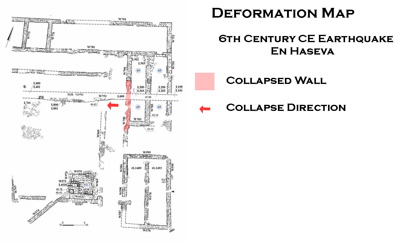 Deformation Map
Modified by JW from Fig. 4 of Erickson-Gini and Moore Bekes (2019)
-
Earthquake Archeological Effects chart
of Rodríguez-Pascua et al (2013: 221-224)
 Earthquake Archeological Effects (EAE)
Rodríguez-Pascua et al (2013: 221-224)
| Effect | Location | Image(s) | Description | Intensity |
|---|---|---|---|---|
| Tilted Wall | "Middle Fortress" Gate
Mezad Hazeva: plan of the Roman fortress and the two Iron Age fortresses
Stern et. al. (1993)
The middle fortress (Stratum 5) from the ninth-eighth centuries BCE occupies roughly four times the areal extent
of contemporaneous Negev fortresses. Perhaps the site should be regarded as a small administrative city, like the Judean
fortified city of Tel Beersheba, rather than a large fortress. Courtesy of the Israel Antiquities Authority.
Cohen and Yisrael (1995) |
Figure 5 Foundation failure beneath the inside pier of the fortress gate at `En Haseva. Although the Iron Age fortress gate is superbly constructed of well-hewn stones, individual blocks within the pier cracked on several courses as the foundation compacted differentially. The whole pier of the gate now leans northeastward. The excavators of the gate complex associated destruction debris within the gate complex to damage caused by an earthquake, not foundation failure caused by a continuous process of creep. Austin et al (2000)
Digital Theodolite Shot of Tilted Iron Age Gate Wall at En HatsevaPhoto by Jefferson Williams 12 Jan. 2023
Oblique Aerial Shot of Iron Age Gate at En HatsevaPhoto by Jefferson Williams 6 Jan. 2023 |
VI + |
-
Earthquake Archeological Effects chart
of Rodríguez-Pascua et al (2013: 221-224)
Earthquake Archeological Effects (EAE)
Rodríguez-Pascua et al (2013: 221-224)
| Effect | Location | Image(s) | Description | Intensity |
|---|---|---|---|---|
| Collapsed arches | Room 45 in the Cavalry Camp (aka Roman Camp)
Figure 1.83 ‘En Hazeva, 1990-1994 excavations (Note revised plan of the cavalry camp in Fig. 1.58) Erickson-Gini (2010)
Figure 11Aerial photo of Area E prior to balk removal, looking northwest Erickson-Gini and Moore Bekes (2019)
Figure 4The eastern part of the camp, plan JW: locations Room 45 - upper right Wall 785 - mid right Room 53 - bottom center Wall W578 - bottom right Erickson-Gini and Moore Bekes (2019) |
Figure 6 Line of collapsed arches over a layer of ash in Room 45, looking west Erickson-Gini and Moore Bekes (2019)
Figure 7Line of collapsed arches over a layer of ash in Room 45, looking east. Erickson-Gini and Moore Bekes (2019) |
A north–south wall (W785), running through the center of the room was exposed to its full length. The wall was made up of pilasters and collapsed arches over a layer of dark soil and ash (Fig.s 6, 7)- Erickson-Gini and Moore Bekes (2019) |
VI+ |
|
Room 53 (aka the Treasury Vault) in the Cavalry Camp (aka Roman Camp)
Figure 1.83 ‘En Hazeva, 1990-1994 excavations (Note revised plan of the cavalry camp in Fig. 1.58) Erickson-Gini (2010)
Figure 11Aerial photo of Area E prior to balk removal, looking northwest Erickson-Gini and Moore Bekes (2019)
Figure 4The eastern part of the camp, plan JW: locations Room 45 - upper right Wall 785 - mid right Room 53 - bottom center Wall W578 - bottom right Erickson-Gini and Moore Bekes (2019)
Figure 9Room 53, plan and sections Erickson-Gini and Moore Bekes (2019) |
According to the 1994–1995 field notes by Y. Kalman, Area E supervisor, Room 53 was filled with collapsed debris, stone slabs that were used for roofing, arch stones and other building stones. The structure probably collapsed in the 363 CE earthquake.- Erickson-Gini and Moore Bekes (2019) |
|
constructed on shallow foundations in soilwhile the Roman Fort was
founded on the walls of earlier buildings on the tell.
-
Earthquake Archeological Effects chart
of Rodríguez-Pascua et al (2013: 221-224)
Earthquake Archeological Effects (EAE)
Rodríguez-Pascua et al (2013: 221-224)
| Effect | Location | Image(s) | Description | Intensity |
|---|---|---|---|---|
| Collapsed wall (collapsed to the west) |
western wall of Room 45 (W790)
Figure 4 The eastern part of the camp, plan JW: locations Room 45 - upper right Wall 785 - mid right Room 53 - bottom center Wall W578 - bottom right Erickson-Gini and Moore Bekes (2019)
Figure 11Aerial photo of Area E prior to balk removal, looking northwest Erickson-Gini and Moore Bekes (2019) |
Evidence of damage caused by the earthquake that occurred in the sixth century CE was found in the collapse of the western wall of Room 45 (W790); it fell into an open space west of the room (L600)- Erickson-Gini and Moore Bekes (2019) |
VIII + |
Orthophoto of En HasevaClick on Image to open a high resolution magnifiable image in a new tab
From Drone Survey by Jefferson Williams 12 Jan. 2023
| Description | Photo | Comments |
|---|---|---|
| Oblique Aerial Shot of Entire Site |
Oblique Aerial Shot of entire excavated site of En Hatseva Photo by Jefferson Williams 12 Jan. 2023 |
|
| Cropped Oblique Aerial Shot of Entire Site |
Cropped Oblique Aerial Shot of entire excavated site of En Hatseva Photo by Jefferson Williams 12 Jan. 2023 |
|
| Oblique Aerial Shot of Iron Age Gate |
Oblique Aerial Shot of Iron Age Gate at En Hatseva Photo by Jefferson Williams 6 Jan. 2023 |
|
| Tilted Wall of Iron Age Gate |
Tilted Iron Age Wall at En Hatseva Photo by Jefferson Williams 6 Jan. 2023 |
|
| Tilted Wall of Iron Age Gate (Digital Theodolite) |
Digital Theodolite Shot of Side View Tilted Iron Age Wall at En Hatseva Photo by Jefferson Williams 12 Jan. 2023 |
|
| Orientation Measurement (Az = 51°) of Wall of Iron Age Gate (Digital Compass) |
 Orientation Measurement (Az = 51°) of Wall of Iron Age Gate at En Hatseva
Photo by Jefferson Williams 12 Jan. 2023 |
|
| Tilt Measurement (8.6°) of Wall of Iron Age Gate (Digital Theodolite) |
 Digital Theodolite Measurement of Tilt of 8.6° of Iron Age Wall at En Hatseva
Photo by Jefferson Williams 12 Jan. 2023 |
|
| Tilt Measurement (7°) of Wall of Iron Age Gate (Clinometer) |
 Tilt Measurement of Tilt of 7° of Iron Age Wall at En Hatseva
Photo by Jefferson Williams 12 Jan. 2023 |
|
| Slumped and Faulted Walls |
 Slumped and Faulted Walls at En Hatseva
Photo by Jefferson Williams 12 Jan. 2023 |
|
| Slumped and Faulted Walls (Digital Theodolite) |
 Digital Theodolite Shot of Slumped and Faulted Walls at En Hatseva
Photo by Jefferson Williams 12 Jan. 2023 |