Tell ej-Judeideh
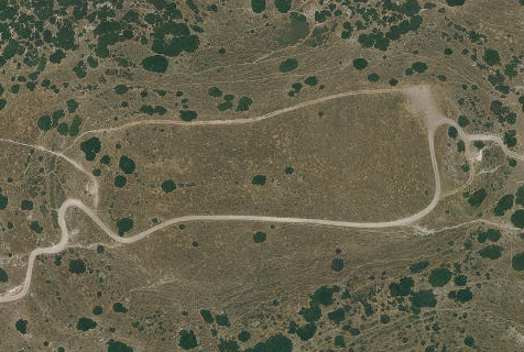 Aerial View of Tell ej-Judeideh
Click on Image for high resolution magnifiable map
from www.govmap.gov.il
| Transliterated Name | Source | Name |
|---|---|---|
| Tell ej-Judeideh | Arabic | خربة الجديدة |
| Tell ej-Judeideh | Arabic | تل الجديدة |
| Tell Goded | Modern Hebrew | תל גודד |
| Moresheth-Gath | Biblical Hebrew | מוֹרֶשֶׁת גַּת |
- Fig. 1 Map with location of
Tel Goded (aka Tell ej-Judeideh) from Schniedewind (1998)
 Figure 1
Topography of southern coast and Judaean Shephelah
Schniedewind (1998)
- Fig. 1 Map with location of
Tel Goded (aka Tell ej-Judeideh) from Schniedewind (1998)
Figure 1
Topography of southern coast and Judaean Shephelah
Schniedewind (1998)
- Tell ej-Judeideh in Google Earth
 Tell ej-Judeideh
click on image to explore this site on a new tab in Google Earth - Tell ej-Judeideh on govmap.gov.il
Tell ej-Judeideh
click on image to explore this site on a new tab in govmap.gov.il
- Fig. 1 - Site Plan from
Gibson (1994)
 Figure 1
General plan of the summit of Tell ej-Judeideh, showing the position of the five shafts (=S) and the six pits (Bliss 1900b: Pl. I, with corrections and additions based on PEF materials).
Gibson (1994) - Pl. I - Site plan with
locations of excavation pits from Bliss (1900b)
 Plate I
Bliss (1900b)
- Fig. 1 - Site Plan from
Gibson (1994)
Figure 1
General plan of the summit of Tell ej-Judeideh, showing the position of the five shafts (=S) and the six pits (Bliss 1900b: Pl. I, with corrections and additions based on PEF materials).
Gibson (1994) - Pl. I - Site plan with
locations of excavation pits from Bliss (1900b)
Plate I
Bliss (1900b)
- Fig. 4 - Plan of Pit 4
Iron IIB (upper phase) structures from Gibson (1994)
 Figure 4
Pit 4: Iron IIB (upper phase) structures
(after a sketch and measurements by Macalister: PEF Archives: BLISS/l51/2).
Gibson (1994) - Fig. 7 - Plan of Pit 5
Iron IIB (upper phase) structures from Gibson (1994)
 Figure 7
Pit 5: Iron IIB (upper phase) structures
(after a sketch and measurements by Macalister: PEF Archives: BLISS/l51/2).
Gibson (1994)
- Fig. 4 - Plan of Pit 4
Iron IIB (upper phase) structures from Gibson (1994)
Figure 4
Pit 4: Iron IIB (upper phase) structures
(after a sketch and measurements by Macalister: PEF Archives: BLISS/l51/2).
Gibson (1994) - Fig. 7 - Plan of Pit 5
Iron IIB (upper phase) structures from Gibson (1994)
Figure 7
Pit 5: Iron IIB (upper phase) structures
(after a sketch and measurements by Macalister: PEF Archives: BLISS/l51/2).
Gibson (1994)
- Plate 101 - Plan of Pit 4
from Bliss & Macalister (1902)
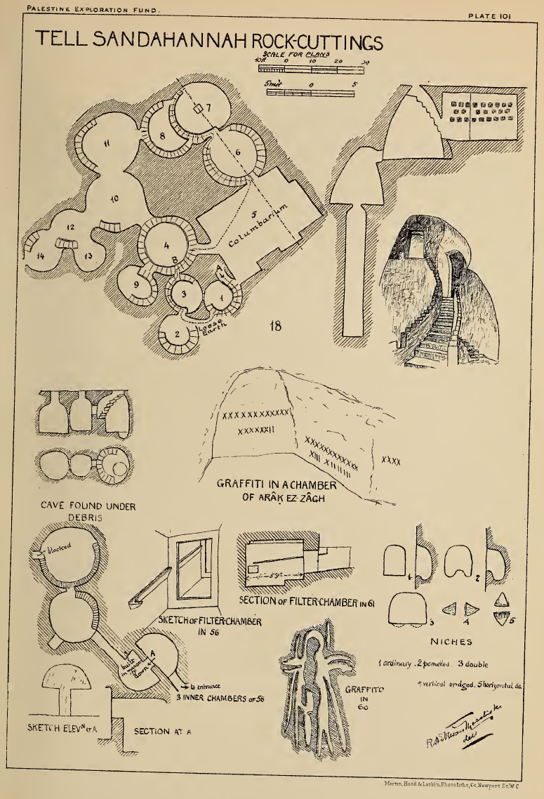 Plate 101
Tell Sandahannah Rock Cuttings
click on image to open in a new tab
Bliss & Macalister (1902)
- Plate 101 - Plan of Pit 4
from Bliss & Macalister (1902)
Plate 101
Tell Sandahannah Rock Cuttings
click on image to open in a new tab
Bliss & Macalister (1902)
- Fig. 1 - Plan of Tell ej-Judeideh
from Gibson (1994)
Figure 1
General plan of the summit of Tell ej-Judeideh, showing the position of the five shafts (=S) and the six pits (Bliss 1900b: Pl. I, with corrections and additions based on PEF materials).
Gibson (1994) - Pl. I - Plan of Tell ej-Judeideh
showing locations of excavation pits from Bliss (1900b)
Plate I
Bliss (1900b) - Fig. 4 - Plan of Pit 4 Iron IIB (upper phase)
structures from Gibson (1994)
Figure 4
Pit 4: Iron IIB (upper phase) structures
(after a sketch and measurements by Macalister: PEF Archives: BLISS/l51/2).
Gibson (1994) - Fig. 7 - Plan of Pit 5 Iron IIB (upper phase)
structures from Gibson (1994)
Figure 7
Pit 5: Iron IIB (upper phase) structures
(after a sketch and measurements by Macalister: PEF Archives: BLISS/l51/2).
Gibson (1994)
- Figure 3 - Time-stratigraphic correlation
chart of Iron IIb excavations throughout an extensive region of Israel and Jordan from Austin et. al. (2000)
 FIG. 3
Time-stratigraphic correlation chart of Iron IIb excavations throughout an extensive region of Israel and Jordan. Datum for correlation is earthquake debris or rebuilding horizons assigned to a single, 750 B.C. seismic event. Locations of cities are shown in Figure 1. Strata names at each site are from primary archaeological reports.
Symbols
- P = pottery date
- C-14 = radiocarbon date
- T = dated text material
- D = military destruction layer with historical date assigned
- A = historically dated architectural style
- E = earthquake destruction layer
- E ? = probable earthquake destruction layer (significant rebuilding horizon without evidence of military conquest)
Austin et. al. (2000)
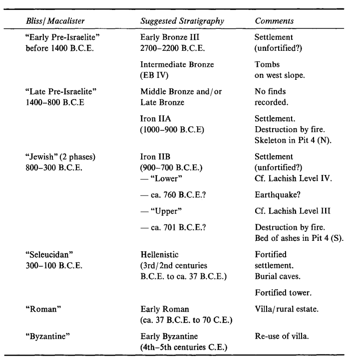
Another fortified Iron Age city of Judah was Tell Judeideh, located eight km northeast of Lachish. Excavations at Tell Judeideh by Bliss and Macalister (1902) showed that the Iron IIb could be divided into two phases. Bliss and Macalister provide no answers to the destruction of the lower phase. However, Gibson (1994), after an extensive review of the archival materials, noted that pottery of the two phases has strong stratigraphic correlation to Level III and IV of nearby Lachish. He agreed with Ussishkin and Dever that earthquake destruction debris marks the top of Lachish Level IV. Therefore, Gibson (1994, p. 230) concluded that an earthquake in approximately 760 B.C destroyed Tell Judeideh's lower-phase buildings.
| Effect | Location | Image(s) | Discussion |
|---|---|---|---|
| Destroyed Structures | Pit 4
Figure 4 Pit 4: Iron IIB (upper phase) structures (after a sketch and measurements by Macalister: PEF Archives: BLISS/l51/2). Gibson (1994) |
|
|
| Re-used building elements | Pit 4
Figure 4 Pit 4: Iron IIB (upper phase) structures (after a sketch and measurements by Macalister: PEF Archives: BLISS/l51/2). Gibson (1994) |
|
- Earthquake Archeological Effects chart
of Rodríguez-Pascua et al (2013: 221-224)
 Earthquake Archeological Effects (EAE)
Rodríguez-Pascua et al (2013: 221-224)
| Effect | Location | Image(s) | Discussion | Intensity |
|---|---|---|---|---|
| Collapsed Walls (Destroyed Structures) | Pit 4
Figure 4 Pit 4: Iron IIB (upper phase) structures (after a sketch and measurements by Macalister: PEF Archives: BLISS/l51/2). Gibson (1994) |
|
VIII+ |