Megiddo

 Left
LeftTel Megiddo from the NorthWest
Click on Image for high resolution magnifiable image
Used with permission from BibleWalks.com
Right
Tel Megiddo from the Southeast
Click on Image for high resolution magnifiable image
Drone photos taken by Jefferson Williams on 27 April 2023
- Fig. 31.1 - Faults and Epicenters near Meggiddo
from Marco et. al. (2006)
 Fig. 31.1
Location of faults near Megiddo and recent earthquake epicentres in the vicinity of the Carmel Fault. Earthquake data from the Geophysical Institute of Israel
- Y - Yoqne'am
- M - Megiddo
- T - Ta'anach
Marco et. al. (2006) - Fig. 25 Late Iron I destructions
in the southern Levant from Kleiman et al. (2023)
 Fig. 25
Late Iron I destructions in the southern Levant. A few of these sites, e.g., Shiloh, were devastated slightly earlier, in the middle Iron I, while other sites, e.g., Khirbet Qeiyafa and Tel Miqne/Ekron (Stratum IV), were destroyed a bit later, in the Iron I/II transition
Kleiman et al. (2023)
- Annotated Aerial View of
Tel Megiddo from biblewalks.com
- Annotated Aerial View of
Tel Megiddo from the north from BibleWalks.com
- Unannotated Aerial View of
Tel Megiddo from the north from BibleWalks.com
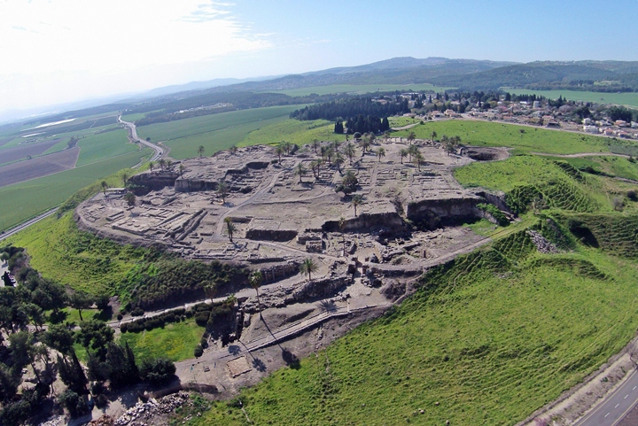
- Aerial View of Tel Megiddo
from wikipedia
 Tel Megiddo with archaeological remains from the Bronze and Iron Ages
Click on Image for high resolution magnifiable image
AVRAM GRAICER - wikipedia - CC by SA 3.0 - Aerial View of Tel Megiddo
in 1948 from Loud (1948)
 Air View of The Mound
Loud (1948) - Fig. 2 Annotated Aerial View
of Tel Megiddo and Tel Megiddo East from Sapir-Hen et al. (2022)
 Fig. 2
The dual site of Megiddo and Tel Megiddo East in the Early Bronze Age Ib.
(Illustration by M. J. Adams)
Sapir-Hen et al. (2022) - Megiddo in Google Earth
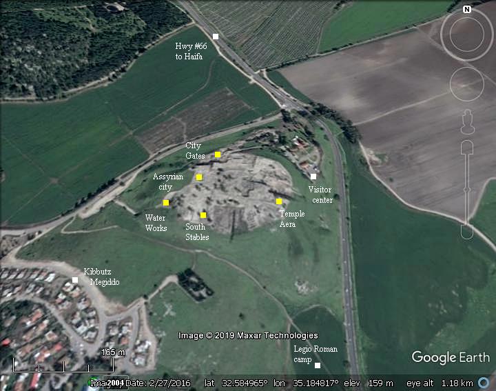
 Megiddo in Google Earth
click on image to explore this site on a new tab in Google Earth - Megiddo on govmap.gov.il
 Megiddo on govmap.gov.il
click on image to explore this site on a new tab in govmap.gov.il

- Fig. 5.1 - Map of the
mound and excavation areas of the Tel Aviv University expedition from Ussishkin (2018))
 Fig. 5.1
Excavation areas of the Tel Aviv University expedition
Ussishkin (2018) - Map of the site and
renewed excavation areas from Stern et al (2008 v. 5)
 Megiddo: map of the site, showing excavation areas
Stern et al (2008 v. 5) - Fig. 1 Map of the site
with excavation areas from Kleiman et al. (2023)
 Fig. 1
Aerial view of Megiddo, looking north, indicating the excavation areas discussed in the article
(courtesy of the Megiddo Expedition).
Kleiman et al. (2023)
- Fig. 5.1 - Map of the
mound and excavation areas of the Tel Aviv University expedition from Ussishkin (2018))
Fig. 5.1
Excavation areas of the Tel Aviv University expedition
Ussishkin (2018) - Map of the site and
renewed excavation areas from Stern et al (2008 v. 5)
Megiddo: map of the site, showing excavation areas
Stern et al (2008 v. 5) - Fig. 1 Map of the site
with excavation areas from Kleiman et al. (2023)
Fig. 1
Aerial view of Megiddo, looking north, indicating the excavation areas discussed in the article
(courtesy of the Megiddo Expedition).
Kleiman et al. (2023)
- Plan of Strata
VA-IVB and IVA from Stern et al (1993 v. 3)
 Megiddo: plan of the city and main buildings in strata VA-IVB and IVA.
Stern et al (1993 v. 3) - Fig. 15.2 - Plan of
Strata VA-IVB from Ussishkin (2018)
 Fig. 15:2
Plan of Stratum VA-IVB
Ussishkin (2018) - Fig. 18.1 - Plan of
Stratum IVA from Ussishkin (2018)
 Fig. 18:1
Plan of Stratum IVA
Ussishkin (2018) - Fig. 19.3 - Plan of
Stratum III from Ussishkin (2018)
 Fig. 19:3
Plan of Stratum III, after Ze'ev Herzog
Ussishkin (2018) - Fig. 24 Evidence for
the fierce conflagration of Stratum VIA from Kleiman et al. (2023)
 Fig. 24
Evidence for the fierce conflagration of Stratum VIA at Megiddo; areas with evidence for burials/human remains under collapse are indicated. Though the stratigraphic situation in Area BB is fuzzy, signs of a violent event were found there too.
Kleiman et al. (2023)
- Plan of Strata
VA-IVB and IVA from Stern et al (1993 v. 3)
Megiddo: plan of the city and main buildings in strata VA-IVB and IVA.
Stern et al (1993 v. 3) - Fig. 15.2 - Plan of
Strata VA-IVB from Ussishkin (2018)
Fig. 15:2
Plan of Stratum VA-IVB
Ussishkin (2018) - Fig. 18.1 - Plan of
Stratum IVA from Ussishkin (2018)
Fig. 18:1
Plan of Stratum IVA
Ussishkin (2018) - Fig. 19.3 - Plan of
Stratum III from Ussishkin (2018)
Fig. 19:3
Plan of Stratum III, after Ze'ev Herzog
Ussishkin (2018)
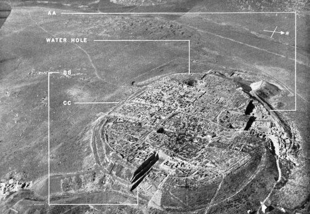
 Fig. 31.2
Location map of deformed structures at Megiddo. Arrows indicate direction of shaking. Stars mark deformation that cannot be associated with a particular sense of movement.
JW: Excavation Area Overlay in Red is approximate
Modified from Marco et. al. (2006)
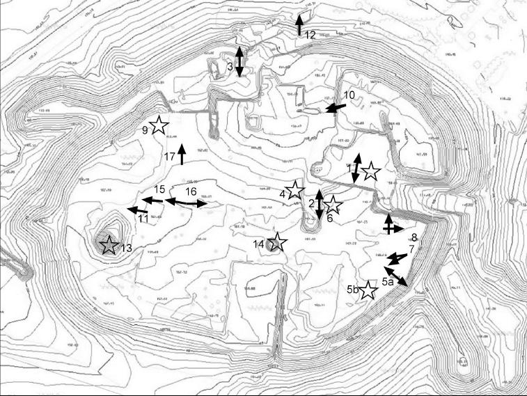 Fig. 31.2
Location map of deformed structures at Megiddo. Arrows indicate direction of shaking. Stars mark deformation that cannot be associated with a particular sense of movement.
Marco et. al. (2006)
- Fig. 2.5a - Excavation
areas of Schumacher from Ussishkin (2018)
 Fig. 2:5a
The plan of the tell and the excavations prepared by Schumacher
Ussishkin (2018) - Fig. 2.5b - North-South
section of Schumacher from Ussishkin (2018)
 Fig. 2:5b
North-South section prepared by Schumacher
Ussishkin (2018) - Fig. 3.5 - Excavation
areas of Oriental Institute expedition (Univ. of Chicago) from Ussishkin (2018)
 Fig. 3:15
The excavation areas of the Oriental Institute expedition
Ussishkin (2018)
- Fig. 2.5a - Excavation
areas of Schumacher from Ussishkin (2018)
Fig. 2:5a
The plan of the tell and the excavations prepared by Schumacher
Ussishkin (2018) - Fig. 2.5b -
North-South section of Schumacher from Ussishkin (2018)
Fig. 2:5b
North-South section prepared by Schumacher
Ussishkin (2018) - Fig. 3.5 - Excavation
areas of Oriental Institute expedition (Univ. of Chicago) from Ussishkin (2018)
Fig. 3:15
The excavation areas of the Oriental Institute expedition
Ussishkin (2018)
- Fig. 2.5b -
North-South section of Schumacher from Ussishkin (2018)
Fig. 2:5b
North-South section prepared by Schumacher
Ussishkin (2018)
- Fig. 5.2 - Plan of
Level H-9 from Finkelstein et al. (2013 Vol. 1)
 Figure 5.2
Plan of Level H-9
Finkelstein et al. (2013 Vol. 1) - Fig. 5.8 - Photo of
Level H-9 from Finkelstein et al. (2013 Vol. 1)
 Figure 5.8
General view of Level H-9, looking north.
Finkelstein et al. (2013 Vol. 1) - Fig. 5.4 - South
section of Area H from Finkelstein et al. (2013 Vol. 1)
 Figure 5.4
South section of Area H (Squares E—F/6).
Finkelstein et al. (2013 Vol. 1) - Fig. 5.5 - East section
of Area H from Finkelstein et al. (2013 Vol. 1)
 Figure 5.5
East section of Area H (Squares F/6-9).
Finkelstein et al. (2013 Vol. 1) - Fig. 5.6 - West section
of Area H from Finkelstein et al. (2013 Vol. 1)
 Figure 5.6
West section of Area H (Squares E/6-9).
Finkelstein et al. (2013 Vol. 1) - Fig. 5.7 - Eastern section
of Area H from Finkelstein et al. (2013 Vol. 1)
 Figure 5.7
Eastern section of Squares E/6-9.
Finkelstein et al. (2013 Vol. 1) - Fig. 5.8 - Photo of
Level H-9 from Finkelstein et al. (2013 Vol. 1)
Figure 5.8
General view of Level H-9, looking north.
Finkelstein et al. (2013 Vol. 1) - Fig. 5.25 - Plan of Level H-5
from Finkelstein et al. (2013 Vol. 1)
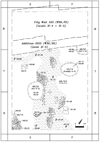 Figure 5.25
Plan of Level H-5
Finkelstein et al. (2013 Vol. 1) - Fig. 5.26 - View of Level H-5 looking north
from Finkelstein et al. (2013 Vol. 1)
 Figure 5.26
General View of Level H-5, looking north
Finkelstein et al. (2013 Vol. 1)
- Fig. 5.2 - Plan of
Level H-9 from Finkelstein et al. (2013 Vol. 1)
Figure 5.2
Plan of Level H-9
Finkelstein et al. (2013 Vol. 1) - Fig. 5.4 - South
section of Area H from Finkelstein et al. (2013 Vol. 1)
Figure 5.4
South section of Area H (Squares E—F/6).
Finkelstein et al. (2013 Vol. 1) - Fig. 5.5 - East section
of Area H from Finkelstein et al. (2013 Vol. 1)
Figure 5.5
East section of Area H (Squares F/6-9).
Finkelstein et al. (2013 Vol. 1) - Fig. 5.6 - West section
of Area H from Finkelstein et al. (2013 Vol. 1)
Figure 5.6
West section of Area H (Squares E/6-9).
Finkelstein et al. (2013 Vol. 1) - Fig. 5.7 - Eastern section
of Area H from Finkelstein et al. (2013 Vol. 1)
Figure 5.7
Eastern section of Squares E/6-9.
Finkelstein et al. (2013 Vol. 1) - Fig. 5.8 - Photo of
Level H-9 from Finkelstein et al. (2013 Vol. 1)
Figure 5.8
General view of Level H-9, looking north.
Finkelstein et al. (2013 Vol. 1) - Fig. 5.25 - Plan of
Level H-5 from Finkelstein et al. (2013 Vol. 1)
Figure 5.25
Plan of Level H-5
Finkelstein et al. (2013 Vol. 1) - Fig. 5.26 - View of
Level H-5 looking north from Finkelstein et al. (2013 Vol. 1)
Figure 5.26
General View of Level H-5, looking north
Finkelstein et al. (2013 Vol. 1)
- Fig. 3.2 Plan of the
Stratum XIX Temple from Finkelstein et al. (2000)
 Figure 3.2
Plan of the Stratum XIX Temple
(after Loud 1948: Fig. 390; Courtesy of The Oriental Institute of The University of Chicago).
Finkelstein et al. (2000) - Fig. 3 Reconstruction
of the Great Temple of Stratum XVIII (Level J-4) from Sapir-Hen et al. (2022)
 Fig. 3
Plan of the Great Temple of Level J-4.
(Illustration by M. J. Adams)
Sapir-Hen et al. (2022) - Fig. 2.7 - Reconstruction
of the Great Temple of Stratum XVIII (Level J-4) from Ussishkin (2011)
 Fig. 2.7
The Great Temple of Stratum XVIII; a reconstructed plan.
Ussishkin (2011) - Fig. 2.37 - Section from
Squares H–G/7–8, eastern section from Adams in Finkelstein et al. (2013)
 Figure 2.37
Squares H–G/7–8, eastern section.
Adams in Finkelstein et al. (2013)
- Fig. 3.2 Plan of the
Stratum XIX Temple from Finkelstein et al. (2000)
Figure 3.2
Plan of the Stratum XIX Temple
(after Loud 1948: Fig. 390; Courtesy of The Oriental Institute of The University of Chicago).
Finkelstein et al. (2000) - Fig. 3 Reconstruction
of the Great Temple of Stratum XVIII (Level J-4) from Sapir-Hen et al. (2022)
Fig. 3
Plan of the Great Temple of Level J-4.
(Illustration by M. J. Adams)
Sapir-Hen et al. (2022) - Fig. 2.7 - Reconstruction
of the Great Temple of Stratum XVIII (Level J-4) from Ussishkin (2011)
Fig. 2.7
The Great Temple of Stratum XVIII; a reconstructed plan.
Ussishkin (2011) - Fig. 2.37 - Section from
Squares H–G/7–8, eastern section from Adams in Finkelstein et al. (2013)
Figure 2.37
Squares H–G/7–8, eastern section.
Adams in Finkelstein et al. (2013)
- Fig. 2.6 - Superposition
of temples in the cultic area from Ussishkin (2011)
 Fig. 2.6
Diagram showing the superposition of the temples in the cultic area:
- at the bottom, at left – the Stratum XIX temple
- above it, and further to the right – The Great Temple of Stratum XVIII
- above it – the Round Altar (Stratum XVI) and the three Megaron Temples (Stratum XV)
- at the top – the Tower Temple of the Middle and Late Bronze Ages
Ussishkin (2011)
- Fig. 2.6 - Superposition
of temples in the cultic area from Ussishkin (2011)
Fig. 2.6
Diagram showing the superposition of the temples in the cultic area:
- at the bottom, at left – the Stratum XIX temple
- above it, and further to the right – The Great Temple of Stratum XVIII
- above it – the Round Altar (Stratum XVI) and the three Megaron Temples (Stratum XV)
- at the top – the Tower Temple of the Middle and Late Bronze Ages
Ussishkin (2011)
- Fig. 7.7 Plan of
Level K-4 from Finkelstein et al. (2006)
 Figure 7.7
Plan of Level K-4
Finkelstein et al. (2006)
- Fig. 7.7 Plan of
Level K-4 from Finkelstein et al. (2006)
Figure 7.7
Plan of Level K-4
Finkelstein et al. (2006)
- Fig. 4.20 - Plan of
Level M-4 from Finkelstein et al. (2013 Vol. 1)
 Figure 4.20
Plan of Level M-4.
Finkelstein et al. (2013 Vol. 1) - Fig. 5.1 Left - Location
of Area M vis-a-vis the central sector of Schumacher's trench (plan) from Finkelstein et al. (2006)
 Figure 5.1
Location of Area M vis-a-vis the central sector of Schumacher's trench. Plan.
(based on Loud 1948: Fig. 415)
Finkelstein et al. (2006) - Fig. 5.1 Right - Location
of Area M vis-a-vis the central sector of Schumacher's trench (Aerial view) from Finkelstein et al. (2006)
 Figure 5.1
Location of Area M vis-a-vis the central sector of Schumacher's trench. Aerial view 1998, looking north.
Finkelstein et al. (2006)
- Fig. 4.20 - Plan of
Level M-4 from Finkelstein et al. (2013 Vol. 1)
Figure 4.20
Plan of Level M-4.
Finkelstein et al. (2013 Vol. 1) - Fig. 5.1 Left - Location
of Area M vis-a-vis the central sector of Schumacher's trench (plan) from Finkelstein et al. (2006)
Figure 5.1
Location of Area M vis-a-vis the central sector of Schumacher's trench. Plan.
(based on Loud 1948: Fig. 415)
Finkelstein et al. (2006) - Fig. 5.1 Right - Location
of Area M vis-a-vis the central sector of Schumacher's trench (Aerial view) from Finkelstein et al. (2006)
Figure 5.1
Location of Area M vis-a-vis the central sector of Schumacher's trench. Aerial view 1998, looking north.
Finkelstein et al. (2006)
- Fig. 2 Aerial view of
Squares H–I/4–5 in Area Q from Kleiman et al. (2023)
 Fig. 2
Aerial view of Squares H–I/4–5 in Area Q at the end of the 2016 season, looking north
(courtesy of the Megiddo Expedition).
Kleiman et al. (2023) - Fig. 4 Plan of Level
Q-9 of the Late Bronze III from Kleiman et al. (2023)
 Fig. 4
Plan of Level Q-9 of the Late Bronze III (this phase was revealed only in limited probes below the floors of Level Q-8)
(courtesy of the Megiddo Expedition).
Kleiman et al. (2023) - Fig. 6 Plan of Level
Q-8 from Kleiman et al. (2023)
 Fig. 6
Plan of Level Q-8; shaded walls signify elements built in a previous occupational phase and reused
(courtesy of the Megiddo Expedition).
Kleiman et al. (2023) - Fig. 8 Plan of Level
Q-7b from Kleiman et al. (2023)
 Fig. 8
Plan of Level Q-7b; shaded walls signify elements built in a previous occupational phase and reused
(courtesy of the Megiddo Expedition).
Kleiman et al. (2023) - Fig. 10 Plan of Level
Q-7a from Kleiman et al. (2023)
 Fig. 10
Plan of Level Q-7a; shaded walls signify elements built in a previous occupational phase and reused
(courtesy of the Megiddo Expedition).
Kleiman et al. (2023)
- Fig. 2 Aerial view of
Squares H–I/4–5 in Area Q from Kleiman et al. (2023)
Fig. 2
Aerial view of Squares H–I/4–5 in Area Q at the end of the 2016 season, looking north
(courtesy of the Megiddo Expedition).
Kleiman et al. (2023) - Fig. 4 Plan of Level
Q-9 of the Late Bronze III from Kleiman et al. (2023)
Fig. 4
Plan of Level Q-9 of the Late Bronze III (this phase was revealed only in limited probes below the floors of Level Q-8)
(courtesy of the Megiddo Expedition).
Kleiman et al. (2023) - Fig. 6 Plan of Level
Q-8 from Kleiman et al. (2023)
Fig. 6
Plan of Level Q-8; shaded walls signify elements built in a previous occupational phase and reused
(courtesy of the Megiddo Expedition).
Kleiman et al. (2023) - Fig. 8 Plan of Level
Q-7b from Kleiman et al. (2023)
Fig. 8
Plan of Level Q-7b; shaded walls signify elements built in a previous occupational phase and reused
(courtesy of the Megiddo Expedition).
Kleiman et al. (2023) - Fig. 10 Plan of Level
Q-7a from Kleiman et al. (2023)
Fig. 10
Plan of Level Q-7a; shaded walls signify elements built in a previous occupational phase and reused
(courtesy of the Megiddo Expedition).
Kleiman et al. (2023)
- Fig. 3.2 Plan of the
Stratum XIX Temple from Finkelstein et al. (2000)
Figure 3.2
Plan of the Stratum XIX Temple
(after Loud 1948: Fig. 390; Courtesy of The Oriental Institute of The University of Chicago).
Finkelstein et al. (2000) - Fig. 3.1 Aerial view of
f Area J at the end of the 1996 season from Finkelstein et al. (2000)
 Figure 3.1
Aerial view of Area J at the end of the 1996 season; looking east.
Finkelstein et al. (2000) - Fig. 31.3D - Fractured
Temple Walls from Marco et. al. (2006)
 Figure 31.3D
In Area J, the monumental walls of the Level J-4 temple are fractured in several places along their strike (Fig. 31.3d) as well as perpendicular to the strike (Figs. 31.3e-f). The overlying walls of the EB III temple 4050 are not fractured
Marco et. al. (2006) - Fig. 31.3E - Fractured
Temple Walls from Marco et. al. (2006)
 Figure 31.3E
In Area J, the monumental walls of the Level J-4 temple are fractured in several places along their strike (Fig. 31.3d) as well as perpendicular to the strike (Figs. 31.3e-f). The overlying walls of the EB III temple 4050 are not fractured
Marco et. al. (2006) - Fig. 31.3F - Fractured
Temple Walls from Marco et. al. (2006)
 Figure 31.3F
In Area J, the monumental walls of the Level J-4 temple are fractured in several places along their strike (Fig. 31.3d) as well as perpendicular to the strike (Figs. 31.3e-f). The overlying walls of the EB III temple 4050 are not fractured
Marco et. al. (2006) - Fig. 40.1 - Extension
Fractures in Stone Wall of Level J-4 Temple from Finkelstein et al. (2013 Vol. 3)
 Figure 40.1
Wall 96/J/1 in Square H-10, looking east. Note fracture along the strike on the edge of the wall.
Finkelstein et al. (2013 Vol. 3) - Fig. 2.28 - J-4 Temple
Collapse Layer from Adams in Finkelstein et al. (2013)
 Figure 2.28
Square H/7 east section. Striated remains near the base of the section are Level J-4a squatter’s debris and temple collapse (see also Fig. 2.38). At left, Probe 06/J/099/PT003 reveals the bottom of Wall 00/J/21. Note phytolith level 08/J/185 in low baulk at right.
Adams in Finkelstein et al. (2013) - Fig. 2.47 - Strike Fractures
in Temple 4040 from Adams in Finkelstein et al. (2013)
 Figure 2.47
Strike fractures in Temple 4040 Wall 08/J/38.
Adams in Finkelstein et al. (2013)
- Fig. 3.2 Plan of the
Stratum XIX Temple from Finkelstein et al. (2000)
Figure 3.2
Plan of the Stratum XIX Temple
(after Loud 1948: Fig. 390; Courtesy of The Oriental Institute of The University of Chicago).
Finkelstein et al. (2000) - Fig. 3.1 Aerial view of
Area J at the end of the 1996 season from Finkelstein et al. (2000)
Figure 3.1
Aerial view of Area J at the end of the 1996 season; looking east.
Finkelstein et al. (2000) - Fig. 31.3D - Fractured
Temple Walls from Marco et. al. (2006)
Figure 31.3D
In Area J, the monumental walls of the Level J-4 temple are fractured in several places along their strike (Fig. 31.3d) as well as perpendicular to the strike (Figs. 31.3e-f). The overlying walls of the EB III temple 4050 are not fractured
Marco et. al. (2006) - Fig. 31.3E - Fractured
Temple Walls from Marco et. al. (2006)
Figure 31.3E
In Area J, the monumental walls of the Level J-4 temple are fractured in several places along their strike (Fig. 31.3d) as well as perpendicular to the strike (Figs. 31.3e-f). The overlying walls of the EB III temple 4050 are not fractured
Marco et. al. (2006) - Fig. 31.3F - Fractured
Temple Walls from Marco et. al. (2006)
Figure 31.3F
In Area J, the monumental walls of the Level J-4 temple are fractured in several places along their strike (Fig. 31.3d) as well as perpendicular to the strike (Figs. 31.3e-f). The overlying walls of the EB III temple 4050 are not fractured
Marco et. al. (2006) - Fig. 40.1 - Extension
Fractures in Stone Wall of Level J-4 Temple from Finkelstein et al. (2013 Vol. 3)
Figure 40.1
Wall 96/J/1 in Square H-10, looking east. Note fracture along the strike on the edge of the wall.
Finkelstein et al. (2013 Vol. 3) - Fig. 2.28 - J-4 Temple
Collapse Layer from Adams in Finkelstein et al. (2013)
Figure 2.28
Square H/7 east section. Striated remains near the base of the section are Level J-4a squatter’s debris and temple collapse (see also Fig. 2.38). At left, Probe 06/J/099/PT003 reveals the bottom of Wall 00/J/21. Note phytolith level 08/J/185 in low baulk at right.
Adams in Finkelstein et al. (2013) - Fig. 2.47 - Strike Fractures
in Temple 4040 from Adams in Finkelstein et al. (2013)
Figure 2.47
Strike fractures in Temple 4040 Wall 08/J/38.
Adams in Finkelstein et al. (2013)
- Fig. 31.3H - Extension cracks and
shifted Ashlars in the Late Bronze gate from Marco et. al. (2006)
 Figure 31.3H
Extension cracks in the Late Bronze gate. Ashlar stones in courses in the middle of the walls (sandwiched between other courses) are fractured in opening mode. Horizontal sliding of the fragments occurred everywhere in the same direction, sub-parallel to N-S trend of the wall (Fig. 31.3h). The gate has no foundations, a fact that could have made it particularly vulnerable to seismic vibrations.
Marco et. al. (2006)
- Fig. 5.3 - Destruction Layers H-5 and H-9
from Finkelstein et al. (2013 Vol. 1)
 Figure 5.3
Southern section of Area H, looking south. The figure is standing on the floor of Level H-9. From bottom: the thick accumulation debris of Level H-9, the floors of Level H-7 and the destruction of Level H-5. (Note the differences in the nature of destruction between Levels H-9 and H-5.)
Finkelstein et al. (2013 Vol. 1) - Fig. 5.8 - Photo of Level H-9
from Finkelstein et al. (2013 Vol. 1)
Figure 5.8
General view of Level H-9, looking north.
Finkelstein et al. (2013 Vol. 1) - Fig. 5.9 - Smashed storage jar
and charred beam in Level H-9 from Finkelstein et al. (2013 Vol. 1)
 Figure 5.9
Smashed storage jar lying on the floor of Courtyard 08/H/38 of Level H-9 (note charred beam between mudbricks), looking east.
Finkelstein et al. (2013 Vol. 1) - Fig. 5.10 - Complete storage jar in Level H-9
from Finkelstein et al. (2013 Vol. 1)
 Figure 5.10
A complete storage jar on Paved Floor 06/H/51 in the northwestern part of Courtyard 08/H/38 of Level H-9 (note the depth of City Wall 325), looking east.
Finkelstein et al. (2013 Vol. 1) - Fig. 5.11 - Smashed pottery vessels in Level H-9
from Finkelstein et al. (2013 Vol. 1)
 Figure 5.11
Smashed pottery vessels in the eastern part of Courtyard 08/H/38 with Partition wall 06/H/8, Level H-9, looking east.
Finkelstein et al. (2013 Vol. 1) - Fig. 3 Stratum VIA destruction
debris in Area Q from Kleiman et al. (2023)
 Fig. 3
A typical accumulation of the destruction debris of Stratum VIA. The black line at the bottom of the debris signifies the floor; Square I/2 in Area Q, looking north
(courtesy of the Megiddo Expedition).
Kleiman et al. (2023) - Fig. 5 Pottery on the floor of
Level Q-9 from Kleiman et al. (2023)
 Fig. 5
Restorable vessels on the floor of Level Q-9. On the left, the eastern wall of Schumacher’s Südliches Burgtor; looking north
(courtesy of the Megiddo Expedition).
Kleiman et al. (2023) - Fig. 7 Floor of Level Q-8
from Kleiman et al. (2023)
 Fig. 7
Floor 14/Q/106 of Level Q-8 below remains of Level Q-7, looking north
(courtesy of the Megiddo Expedition).
Kleiman et al. (2023) - Fig. 9 Stone pillars in Area Q
from Kleiman et al. (2023)
 Fig. 9
- Two of the three octagonal stone pillars of a possibly small shrine in Square I/4 after the 2014 season (Building 14/ Q/145), looking east (courtesy of the Tel Aviv University Institute of Archaeology)
- combined 3D model of Squares I/ 3–4 in Area Q, after the exposure of the third octagonal pillar in the 2016 season
(courtesy of the Megiddo Expedition).
Kleiman et al. (2023) - Fig. 11a pavement of Level Q-7a
building from Kleiman et al. (2023)
 Fig. 11a
The pavement of the new Level Q-7a building erected above Building 14/Q/145, looking north-east; note the third pillar of Building 14/Q/145 on the right side of the photo
(courtesy of the Megiddo Expedition).
Kleiman et al. (2023) - Fig. 11b broken stelae originating
from pavement of Building 16/Q/48 from Kleiman et al. (2023)
 Fig. 11b
one of the broken stelae, which originated from the pavement of Building 16/Q/48
(courtesy of the Megiddo Expedition).
Kleiman et al. (2023) - Fig. 12 Level Q-7 (Stratum VIA)
destruction layer from Kleiman et al. (2023)
 Fig. 12
A view of the destruction of the Level Q-7 (Stratum VIA) city in Squares H/4–5, looking south-east
(courtesy of the Megiddo Expedition).
Kleiman et al. (2023) - Fig. 13 Level Q-6b stone monolith
erected above the ruins of the Iron I destruction from Kleiman et al. (2023)
 Fig. 13
A stone monolith erected in Level Q-6b above the ruins of the Iron I destruction, looking north
(courtesy of the Megiddo Expedition).
Kleiman et al. (2023) - Fig. 14 Skeletal remains
from Stratum VIA destruction in Area Q from Kleiman et al. (2023)
 Fig. 14
Remains of an individual found in Locus 16/Q/79:
- schematic diagram that shows which skeletal elements were recovered (in grey)
- in situ photo of the individual’s right pelvis and femoral head
- proximal ends of right (on left) and left (on right) radii, showing differential size and colouration
- left (on left) and right (on right) fourth metacarpals, showing differential size and colouration
(courtesy of the Megiddo Expedition).
Kleiman et al. (2023) - Fig. 17 Iron blades and stacked
bronze bowls from cache from Locus 12/Q/76 from Kleiman et al. (2023)
 Fig. 17
The cache from Locus 12/Q/76, which contained iron blades placed beside two stacked bronze bowls filled with additional items
(courtesy of the Megiddo Expedition).
Kleiman et al. (2023) - Fig. 21 Burials in Area CC
along with smashed pottery from Kleiman et al. (2023)
 Fig. 21
Burials in Square Q/10 (Locus 1770) in Area CC (Harrison 2004: fig. 73). Note the relationship between the skeletons on the right, with respect to architecture and the smashed pottery
(courtesy of the Institute for the Study of Ancient Cultures of the University of Chicago)
Kleiman et al. (2023) - Fig. 22 Skeletal remains in
Area K from Kleiman et al. (2023)
 Fig. 22
Skeletal remains in articulation in Baulk N–O/11 (Locus 04/K/38) in Area K. Note that the initial exposure of the individual was under Locus 04/K/26
(courtesy of the Megiddo Expedition, previously unpublished photo)
Kleiman et al. (2023) - Fig. 7.10 Destruction
layer of Level K-4 showing collapsed mudbricks and vessels from Finkelstein et al. (2006)
 Figure 7.10
Destruction layer of Level K-4 in the southern baulk of Square N/11. Note collapse of mudbricks and vessels.
Finkelstein et al. (2006) - Fig. 7.11 Destruction
layer of Level K-4 from Finkelstein et al. (2006)
 Figure 7.11
Destruction layer of Level K-4 in Square O/9.
Finkelstein et al. (2006) - Fig. 7.12 Square O/9
with remains of Level K-4 (Tabun 00/K/19), looking south from Finkelstein et al. (2006)
 Figure 7.12
Square O/9 with remains of Level K-4 (Tabun 00/K/19), looking south.
Finkelstein et al. (2006) - Fig. 7.13 Room 00/K/45
of Level K-4 from Finkelstein et al. (2006)
 Figure 7.13
Room 00/K/45 of Level K-4, looking west
Finkelstein et al. (2006) - Fig. 7.14 Square M/11
of Level K-4 from Finkelstein et al. (2006)
 Figure 7.14
Square M/11, looking north. Note plaster floor of Level K-6 and lines of ash cut by a robber trench in the section
Finkelstein et al. (2006)
- Fig. 5.26 - View of Level H-5 looking north
from Finkelstein et al. (2013 Vol. 1)
Figure 5.26
General View of Level H-5, looking north
Finkelstein et al. (2013 Vol. 1) - Fig. 5.27 - Level H-5 Destruction Layer
from Finkelstein et al. (2013 Vol. 1)
 Figure 5.27
The southern section of Area H with Level H-5 destruction in the centre of the picture (note the sloping down of the Level H-5 floor toward Installation 06 H 14 in the right) and Level H-7 floors, looking south.
Finkelstein et al. (2013 Vol. 1) - Fig. 5.28 - Level H-5 Destruction Debris
from Finkelstein et al. (2013 Vol. 1)
 Figure 5.28
Destruction debris on Floor 98 H 62 of Level H-5, looking west.
Finkelstein et al. (2013 Vol. 1)
- Fig. 2.12 - Strata VIII-VII Canaanite Gate
before restoration from Ussishkin (2011)
 Fig. 2.12
The late Canaanite city-gate (Strata VIII-VII)
Ussishkin (2011) - Old photo of the Canaanite Gate
from Stern et al (1993 v. 3)
 LB city gate in area AA.
Stern et al (1993 v. 3)
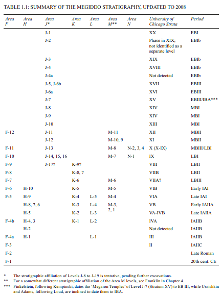 Table 1.1
Summary of Megiddo stratigraphy updated to 2008
Finkelstein et al. (2013 Vol. 1)
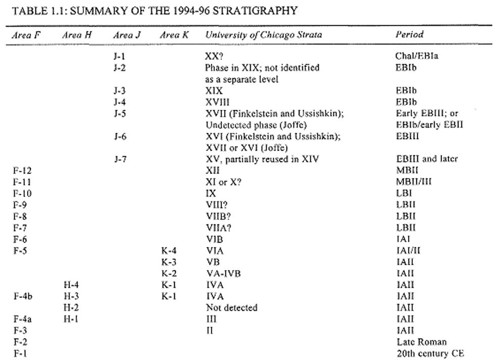 Table 1.1
Summary of the 1994-1996 Stratigraphy
Finkelstein et al. (2000)
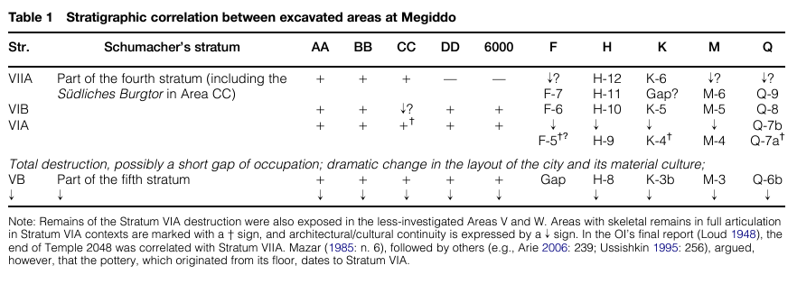 Table 1
Stratigraphic correlation between excavated areas at Megiddo
Kleiman et al. (2023)
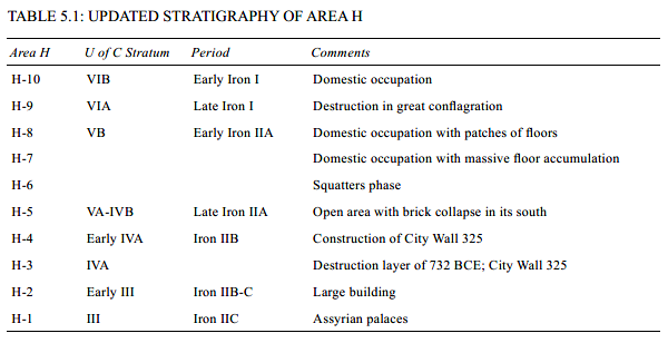 Table 5.1
Updated Stratigraphy of Area H
Finkelstein et al. (2013 Vol. 1)
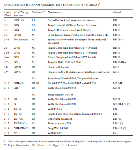 Table 2.2
Revised and Augmented Stratigraphy of Area J
Finkelstein et al. (2013 Vol. 1)
 Figure 3.1
Updated Stratigraphy and Chronology of Early Bronze Age Megiddo
Finkelstein et al. (2006, Megiddo IV: Vol. 1)
 Table 2.6
Schematic Stratigraphic Sequence Of The Level J-4 Floor And The Phase J-4a Activity
Finkelstein et al. (2006, Megiddo IV: Vol. 1)
- from Ussishkin (2015)
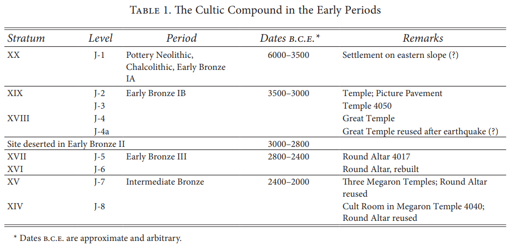 Table 1
The Cultic Compound in the Early Periods
Ussishkin (2015)
 Table 2
The Six Stages of the Sacred Area during Strata XX-XIV Levels J-1 - J-8
Ussishkin (2015)
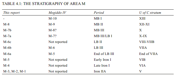 Table 4.1
The Stratigraphy of Area M
Finkelstein et al. (2013 Vol. 1)
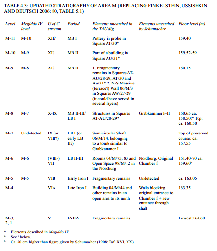 Table 4.3
UPDATED STRATIGRAPHY OF AREA M (REPLACING FINKELSTEIN, USSISHKIN AND DEUTSCH 2006: 80, TABLE 5.1)
Finkelstein et al. (2013 Vol. 1)

 Table 3
Radiocarbon dates from Level Q-9 to Q-6b (Boaretto 2022: table 41.1
Kleiman et al. (2023)
 Fig. 20
The Area Q radiocarbon sequence ((based on the data reported in Boaretto 2022: table 41.1
Kleiman et al. (2023)
- Fig. 3.2 Plan of the
Stratum XIX Temple from Finkelstein et al. (2000)
Figure 3.2
Plan of the Stratum XIX Temple
(after Loud 1948: Fig. 390; Courtesy of The Oriental Institute of The University of Chicago).
Finkelstein et al. (2000) - Fig. 3.1 Aerial view of
f Area J at the end of the 1996 season from Finkelstein et al. (2000)
Figure 3.1
Aerial view of Area J at the end of the 1996 season; looking east.
Finkelstein et al. (2000) - Fig. 31.3D - Fractured
Temple Walls from Marco et. al. (2006)
Figure 31.3D
In Area J, the monumental walls of the Level J-4 temple are fractured in several places along their strike (Fig. 31.3d) as well as perpendicular to the strike (Figs. 31.3e-f). The overlying walls of the EB III temple 4050 are not fractured
Marco et. al. (2006) - Fig. 31.3E - Fractured
Temple Walls from Marco et. al. (2006)
Figure 31.3E
In Area J, the monumental walls of the Level J-4 temple are fractured in several places along their strike (Fig. 31.3d) as well as perpendicular to the strike (Figs. 31.3e-f). The overlying walls of the EB III temple 4050 are not fractured
Marco et. al. (2006) - Fig. 31.3F - Fractured
Temple Walls from Marco et. al. (2006)
Figure 31.3F
In Area J, the monumental walls of the Level J-4 temple are fractured in several places along their strike (Fig. 31.3d) as well as perpendicular to the strike (Figs. 31.3e-f). The overlying walls of the EB III temple 4050 are not fractured
Marco et. al. (2006) - Fig. 40.1 - Extension
Fractures in Stone Wall of Level J-4 Temple from Finkelstein et al. (2013 Vol. 3)
Figure 40.1
Wall 96/J/1 in Square H-10, looking east. Note fracture along the strike on the edge of the wall.
Finkelstein et al. (2013 Vol. 3) - Fig. 2.28 - J-4 Temple
Collapse Layer from Adams in Finkelstein et al. (2013)
Figure 2.28
Square H/7 east section. Striated remains near the base of the section are Level J-4a squatter’s debris and temple collapse (see also Fig. 2.38). At left, Probe 06/J/099/PT003 reveals the bottom of Wall 00/J/21. Note phytolith level 08/J/185 in low baulk at right.
Adams in Finkelstein et al. (2013) - Fig. 2.37 - Section from
Squares H–G/7–8, eastern section from Adams in Finkelstein et al. (2013)
Figure 2.37
Squares H–G/7–8, eastern section.
Adams in Finkelstein et al. (2013) - Fig. 2.47 - Strike Fractures
in Temple 4040 from Adams in Finkelstein et al. (2013)
Figure 2.47
Strike fractures in Temple 4040 Wall 08/J/38.
Adams in Finkelstein et al. (2013)
Marco et. al. (2006) reported that
in Area J, the monumental walls of the Level J-4 temple are fractured in several places along their strike (Fig. 31.3d)
as well as perpendicular to the strike (Figs. 31.3e-f)
while the overlying walls of the EB III temple 4050 are not fractured.
They attributed this to probable catastrophic horizontal shaking
and categorized this as an earthquake event that was
beyond doubt
. This archaeoseismic evidence is indeed compelling.
Israel Finkelstein in Adams et al. (2013 Vol. 3:1331) reports that
Adams in Adams et al. (2013 Vol. 3 Ch.3 Part III) argues against this interpretation attributing
abandonment of the temple in particular and Megiddo in general to socio-political change.
Israel Finkelstein in Adams et al. (2013 Vol. 3:1331) summarized Pro and Con arguments in the Table below while asserting that
an earthquake was likely responsible for the wall fractures.
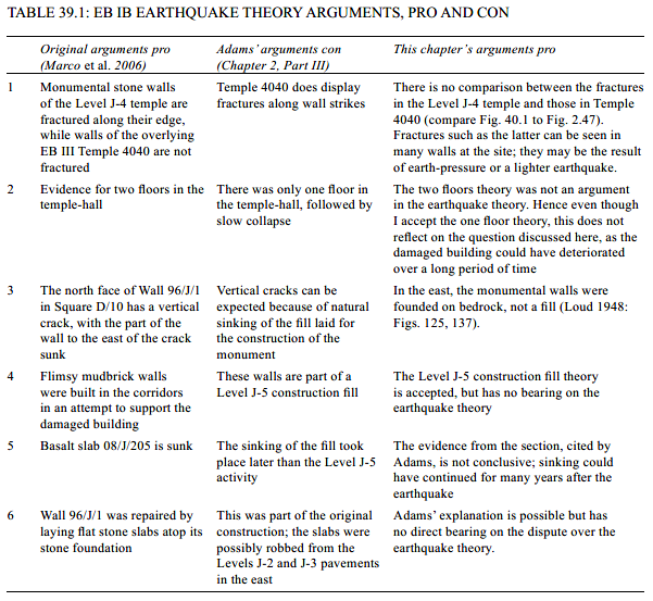 Table 39.1
EB IB Earthquake Theory Arguments, Pro and Con
Israel Finkelstein in Adams et al. (2013 Vol. 3:1331)
In an effort to better understand the sequence of activity during the ‘crisis phase’, a portion of the 2008 season was dedicated to a detailed study of the 10–20 cm accumulation (Figs. 2.28, 2.37) in the Squares H/8–9 baulk, the Squares G–H/7+G–H/8 baulk and the Square J/7 western incision. To complement this approach, a sampling strategy was coordinated with Ruth Shahack-Gross. (The results of the micromorphological analysis of these samples appear in Part V of this chapter; RME numbers refer to these samples, see Table 2.8.)
The simplest of the sequences was excavated in the Square J/7 western incision. Here, the distinct Level J-5 construction Fill 08/J/212 overlaid the robbed Wall 08/J/25, the preserved plaster face of that wall and a 2–3-cm-thick grey-white ash accumulation that also exhibited traces of fired mudbrick fragments (08/J/145). The ash layer overlaid a mud-packed surface with clear signs of heating (low temperature firing of mud surface). Within the ash and clearly upon the floor were a scattering of bones, including an articulation of a young bos primogenius PH2 and 3 (preliminary field identification; notably the species and carcass part itself is statistically rare in the corridor assemblage, Wapnish and Hesse 2000). These bones were not singed; it would appear that the ash, then, was swept away from the primary fire location.
The presence of a distinct and contiguous phytolith layer (08/J/185, RME-30) provided a link between the sequences excavated across the sanctuary and supplied important stratigraphic data regarding this period (Phase J-4a; Figs. 2.43–2.44; see also Fig. 2.28):
- The phytolith layer clearly overlays the circular basalt tables. It is evidenced in the Square G/8 southern baulk and was detected on top of Tables 08/J/207, 08/J/208 and 08/J/205. This phytolith layer was interpreted in Square F/8 in previous seasons as the ‘upper floor’ and also overlaid portions of the rectangular basalt Table 08/J/210. The cavity within Table 08/J/207 was filled with collapsed brick and plaster (Fig. 2.33), and was perfectly sealed by the phytolith layer, demonstrating that the phytolith was deposited after the temple had begun to crumble.
- The phytolith layer completely overlaid the basalt pillar base near the circular tables (Figs. 2.37, 2.44). Certainly the wooden pillars had to have been removed before the deposition of the phytolith layer.
- The phytolith is clearly overlaid by the super compacted and dense clayish-earth mixed with chunky white chalk fragments excavated in Square G/7 and the Squares G/7–8 baulk (08/J/18=08/J/193/LB01; RME-36), where it was confined. These chalk fragments are whiter than the wall plaster of the temple and may not belong to the Level J-4 architecture as we understand it.
- The phytolith layer is clearly overlaid by ca. 15 cm of mudbrick debris and lots of bones. This is the bone layer found in 2000 in Square F/8 (the ‘upper floor’; Finkelstein, Ussishkin and Peersmann 2006: 38). An archaeozoological comparison of this assemblage to that in the bone favissae (corridors) has not yet been made. In what may be a contrast with the corridor favissae ,16 the final deposition of the bones in the sanctuary occurred after the Level J-4 temple began to collapse, i.e., in Phase J-4a.
- The phytolith layer is overlaid and underlaid by ephemeral hearths scattered around the sanctuary (Figs. 2.43–2.44). Several of these hearths, particularly in the Squares G–H/7 baulk, are superimposed as a result of multiple visits. Fragments of collapsed chalk paste from the temple walls were found under, over and between all of these hearths.
- Most noticeably on the northern end of the Squares G–H/7 baulk (Fig. 2.28; but evidenced throughout), the phytolith layer clearly overlies and underlies collapsed plaster debris identical with the plaster preserved on the walls of the Level J-4 temple. This demonstrates that the phytolith layer is but one episode in the slow collapse of the Level J-4 temple after its abandonment.
Table 2.6Schematic Stratigraphic Sequence Of The Level J-4 Floor And The Phase J-4a Activity
Adams in Finkelstein et al. (2013)
adams (chapter 2, Part iii) now argues against our previous interpretation (Finkelstein et al. 2006c: 846), based on the work of marco et al. (2006), according to which the great temple of level J-4 had been damaged by an earthquake and was consequently abandoned for several centuries (in the eb ii). instead, adams relates the abandonment of the temple in particular and megiddo in general to socio-political change. Yet, none of Adams’ arguments is sufficiently strong to change the earthquake theory. Table 39.1 summarizes the arguments pro and con.
Table 39.1EB IB Earthquake Theory Arguments, Pro and Con
Israel Finkelstein in Adams et al. (2013 Vol. 3:1331)
to sum up this issue, the two main pieces of evidence for the earthquake theory – nos. 1 and 3 in the table – have not been challenged and no factual evidence for an alternative theory has thus far been presented. Taking into consideration the sensitive location of Megiddo on the Carmel fault, and the difficult-to-explain abandonment of such a strategic site for several centuries, the earthquake theory should be maintained.
- Fig. 31.3H - Extension cracks and
shifted Ashlars in the Late Bronze gate from Marco et. al. (2006)
Figure 31.3H
Extension cracks in the Late Bronze gate. Ashlar stones in courses in the middle of the walls (sandwiched between other courses) are fractured in opening mode. Horizontal sliding of the fragments occurred everywhere in the same direction, sub-parallel to N-S trend of the wall (Fig. 31.3h). The gate has no foundations, a fact that could have made it particularly vulnerable to seismic vibrations.
Marco et. al. (2006)
- Fig. 7.1 Aerial view of
Megiddo from Nur and Burgess (2008)
 Fig. 7.1
Aerial view of ruins of the ancient city of Megiddo (Armageddon)
Nur and Burgess (2008) - Fig. 7.2 Location map
of Megiddo from Nur and Burgess (2008)
 Fig. 7.2
Location map of Megiddo showing its strategic placement in the local topography
(after Nelson 1913)
Nur and Burgess (2008) - Fig. 7.3 Skeleton and
crushed pottery beneath collapsed wall in Stratum VI at Megiddo from Nur and Burgess (2008)
 Fig. 7.3
Victim of an earthquake. Excavations at Megiddo in 1932–34 uncovered a skeleton buried beneath the rubble of collapsed walls and smashed jars at Stratum VI. Note smashed jar (pithos) next to the body. The earthquake believed to be responsible is that of ca. 1020 BC, also implicated in the death of Doreen at Dor, 40 km west of Megiddo
Nur and Burgess (2008) - Fig. 7.4 Jars full of
carbonized grain found beneath a collapsed wall in Jericho, dated to ca. 1600–1550 BC from Nur and Burgess (2008)
 Fig. 7.4
Jars full of carbonized grain found beneath a collapsed wall in Jericho, dated to ca. 1600–1550 BC by Kathleen Kenyon
(from Kenyon 1953)
Nur and Burgess (2008)
- Fig. 7.1 Aerial view of
Megiddo from Nur and Burgess (2008)
Fig. 7.1
Aerial view of ruins of the ancient city of Megiddo (Armageddon)
Nur and Burgess (2008) - Fig. 7.2 Location map
of Megiddo from Nur and Burgess (2008)
Fig. 7.2
Location map of Megiddo showing its strategic placement in the local topography
(after Nelson 1913)
Nur and Burgess (2008) - Fig. 7.3 Skeleton and
crushed pottery beneath collapsed wall in Stratum VI at Megiddo from Nur and Burgess (2008)
Fig. 7.3
Victim of an earthquake. Excavations at Megiddo in 1932–34 uncovered a skeleton buried beneath the rubble of collapsed walls and smashed jars at Stratum VI. Note smashed jar (pithos) next to the body. The earthquake believed to be responsible is that of ca. 1020 BC, also implicated in the death of Doreen at Dor, 40 km west of Megiddo
Nur and Burgess (2008) - Fig. 7.4 Jars full of
carbonized grain found beneath a collapsed wall in Jericho, dated to ca. 1600–1550 BC from Nur and Burgess (2008)
Fig. 7.4
Jars full of carbonized grain found beneath a collapsed wall in Jericho, dated to ca. 1600–1550 BC by Kathleen Kenyon
(from Kenyon 1953)
Nur and Burgess (2008)
A modest mound southeast of the Carmel Ridge in Israel, the tell of Megiddo rises 50 meters above the surrounding Jezreel Plain and covers some 6 hectares (15 acres) of land (Figure 7.1). This tell was first identified as the legendary Armageddon [the Greek corruption of the Hebrew “Har Megiddo” or Mount Megiddo] by a Jewish writer of the fourteenth century, Esthori Haparchi, and then was rediscovered by the British army officer H. H. Kitchener five hundred years later. Extensive excavations were conducted at the site by C. Fisher, P. Guy, and G. Loud (Yadin 1975). These archaeological studies revealed physical evidence of the historical development of Megiddo.
Megiddo’s strategic importance, belied by its unimposing appearance today, stems from its unique topography (Figure 7.2). The land between the Mediterranean and the Jordan River served as a bridge between the civilizations in the South, in Egypt and Arabia, and those in the North, in Syria, Mesopotamia, and Anatolia. It was also a continuation of sea routes from the Mediterranean and the Gulf of Suez. The ruggedness of the region, however, crossed by several ranges of mountains and hills as well as the lowest valley on Earth, limited the possible routes for overland shipping or wheeled travel. The Carmel-Gilboa mountain range was a particular obstacle, and traffic from the Mediterranean to Syria and Jordan was funneled through a few gaps in the range. In fact, both the passes and the mountain range that obstructed traffic were products of tectonic motion along the seismically active Carmel Gilboa fault system, which branches off from the Dead Sea Transform (see Figure 4.5).
The mound of Megiddo stands guard over one of the most important of these mountain passes, the Nahal Iron Pass, a traffic bottleneck on the main route between Egypt and Syria. Until the advent of more elaborate road construction by the Roman Empire in the first and second centuries AD, the gap at Megiddo was the only one that permitted the passage of chariots, though it was not an easy passage. A description from the latter part of the thirteenth century BC, found in the Egyptian Papyrus Anastasi I, gives some idea of the difficulty of the route:
Thy path is filled with boulders and pebbles, without a toe-hold for passing by, overgrown with reeds, thorns, brambles, and wolf’s paw. The ravine is on one side of thee, and the mountain rises on the other. Thou goest on jolting, with thy chariot on its side, afraid to press thy horse too hard. . . . The horse is played out by the time thou findest night quarters. (Hori [Egyptian Royal Official], Papyrus Anastasi I)This narrow and difficult route made the pass from Megiddo particularly easy to guard, so whoever held power in Megiddo controlled not only the course of trade in the Fertile Crescent but that of war as well. Thus, the site figured prominently in some of the greatest ancient battles fought in this region. As Pharaoh Thutmose III expressed it, “The capture of Megiddo is the capture of 1,000 towns.” Indeed, fortifications were built and rebuilt there for close to five millennia, until around 500 BC (Finkelstein and Ussishkin 1994).
Four levels of destruction in the mound of Tel Megiddo are consistent with earthquake destruction, the lowest one attributed to the conquest by Thutmose III in 1468 BC. Why, however, would the Pharaoh have destroyed the place if his goal were to occupy the site and exact tribute? Although it is clear that Thutmose III conquered Megiddo, there is no more reason to assume that he ordered its physical destruction than to believe it was caused by an earthquake.
The second massive destruction at Megiddo, which occurred around 1250 BC, has variously been attributed to the Israelites or the Philistines, although historical evidence supports neither candidate. Again, however, the excavation of collapsed walls in Megiddo, and similar contemporaneous destruction in many nearby sites (Davies 1986), make the earthquake hypothesis a likely candidate.
The strongest evidence for earthquake destruction at Megiddo is probably the layer dating to between 1130 and 1000 BC, which some scholars attribute to conquest by King David’s army. There is no historical mention, however, of David capturing Megiddo, much less leveling it, and, given the importance of the place at the time, it seems unlikely that such a conquest would go unheralded. More likely, Megiddo was destroyed by a massive earthquake, perhaps the same one that, according to the Bible, occurred during the battle of Michmash (1 Samuel 14:15). In the 1930s, excavators found collapsed walls from this period and, under the walls, smashed jars and several human skeletons, including the one shown in Figure 7.3. This layer is possibly contemporaneous with destruction layers from Dor, Gezer, and at least a dozen other sites in Israel and Jordan, all of them consistent with earthquake destruction.
The fourth layer of destruction occurred sometime after the conquest of Megiddo by Pharaoh Sheshonq in 925 BC. Although this layer is sometimes attributed to him, most documentary and archaeological evidence indicates that Sheshonq did not destroy the city but rather had a monument erected in his honor there and exacted tribute from the residents. Yet, on the other hand, no definitive evidence has yet been excavated to indicate that an earthquake caused this destruction. We know that the massive earthquake during the reign of King Uzziah, around 760 BC, was important in this area—so important, in fact, that it is mentioned in the prophesies in the book of Zechariah (14:4–5):
And his feet shall stand in that day upon the mount of Olives, which is before Jerusalem on the east, and the mount of Olives shall cleave in the midst thereof toward the east and toward the west, and there shall be a very great valley; and half of the mountain shall remove toward the north, and half of it toward the south. And ye shall flee to the valley of the mountains . . . yea, ye shall flee, like as ye fled from before the earthquake in the days of Uzziah king of Judah.Other sources claim that the earthquake Zechariah cites occurred around 760 BC. In any case, clearly it was a major enough disaster to be used as a temporal reference in Zechariah’s prophecy. In fact, the prophecy includes such vivid details that it may actually describe the ground motion that occurred in the 760 BC earthquake, perhaps motion across a strike-slip fault.
Another example of an earthquake prophecy appears in the book of Revelation, where a mighty earthquake is prophesied to occur during the battle of Armageddon:
And they assembled them at the place that in Hebrew is called Armageddon . . . and there came . . . a violent earthquake, such as had not occurred since people were upon the earth, so violent was that earthquake: And the great city was split into three parts, and the cities of the nations fell . . . And every island fled away, and no mountains were to be found.This account and the one in Zechariah may be examples of retrospective prophecies, a common feature in ancient literature where the author dramatizes a historic event as a kind of warning after the fact. This may indicate that, in the past, earthquakes were known to have struck Megiddo. Most important is that excavators keep in mind in future excavations that the area is subject to severe earthquake hazards, and always consider earthquakes as a possible cause for unexplained destruction there.
Topography is what made Megiddo so important militarily for so long, but other factors also determined the location of cities and forts in the ancient Mediterranean region. Another consideration in this arid land was the availability of water. The previous chapter discussed the importance of water in Qumran: dependent on cisterns to capture seasonal rainfall, Qumran was particularly vulnerable to earthquake damage. Cisterns were essential in many Israeli regions, and the collection, storage, and distribution of water was important throughout Israel’s history. Any place with a year-round supply of fresh water, particularly clean, filtered water from a dependable spring, was prime real estate. One example was Jericho, described in chapter 3.
Tel Jericho’s extraordinary stack of at least twenty-two layers of destruction has already been noted. With no modern city built on top of the tell—modern Jericho is a few miles from the remnants of its ancient namesake—archaeological excavation has progressed relatively unhindered, despite the usual impediment of political unrest in the area. This has been a liability in some ways, since excavations using early archaeological methods clearly destroyed at least as much information as they revealed. Still, because of these excavations, the repeated destruction and rebuilding of Jericho has been acknowledged for some time. With its long record and repeated rebuilding, Jericho would be a great candidate for a sort of key site, a place where evidence of repeated earthquake damage could be correlated with destruction in neighboring sites where the record might be less continuous. If we could systematically examine the written evidence of earthquakes and try to tie together the archaeological stratigraphy among the sites scattered around Israel and Jordan, we might be able to piece together a much more informative record than we could hope to gain from any one site alone. A great deal of archaeological work has been done to try to correlate the remains at Jericho with other sites throughout the Holy Land. Kathleen Kenyon (1978) was particularly comprehensive in her synthesis of the archaeology of the region. Although she does mention the general likelihood of earthquakes in this region and specifically ascribes certain damage layers to earthquakes, she makes no explicit effort to determine the range of such earthquake damage; she does not mention whether the earthquake in question could have damaged nearby towns.
One of the most suggestive layers in Jericho is one Kenyon dated, based on pottery styles, to between 1600 and 1550 BC, where the walls of Jericho collapsed, burying storage jars full of grain (Figure 7.4). The grain was carbonized by a fire concurrent with the collapse, and carbon dates of the grain have placed it remarkably close to Kenyon’s original estimate (Bruins and van der Plicht 1996). According to Kenyon (1979, 177–178), many towns in the region suffered total destruction at the same time (though she does not implicate an earthquake), including the sites of Tel Beit Mirsim, Hazor, Shechem, and Megiddo. Among these sites, only Megiddo was immediately rebuilt, with no apparent change in culture; most of the others were abandoned for more than a century.
In chapter 3, I speculated that an earthquake may have figured prominently in the biblical story of Joshua’s destruction of Jericho. Does the archaeological record preserve any evidence at all of Joshua’s Jericho? One of the early expeditions reported the discovery of a city wall from Joshua’s time, but Kenyon (1957) indicated that the dating of that wall was incorrect. As described in chapter 3, she found only one small remnant of Jericho that could have coincided with the traditional estimate of 1400 to 1250 BC for Joshua’s conquest of the site. If a larger habitation did exist at the site, the remains of that culture have all but vanished, eroded away during a long period of abandonment.
Recently, however, archaeologists have reexamined both the archaeological site at Jericho and radiocarbon dates for other events in the ancient world. One particularly notable theory links the plague of darkness in Egypt, before the Exodus, to the explosive eruption of the island of Thera in the Aegean Sea, an event dated to the end of the seventeenth century BC. If this date is correct, the nearly missing layer Kenyon attributed to Joshua’s time would be far too recent, and therefore the destruction from ca. 1600 would be a more likely candidate.
The debate over the assignment of this layer, based on samples of locally made pottery unearthed at Jericho, and on radiocarbon dates from the charred grain and from bits of timber found in the destruction layer, has at times been heated, almost vicious. (For an example of two diametrically opposed interpretations of the same evidence, presented side-by-side in one issue of Biblical Archaeology Review, complete with ad hominem attacks, see Bienkowski 1990 and Wood 1990.) It will be some time before the dust settles on this issue. For now, the archaeology is the source of more questions than answers, and until some of those questions can be resolved, using Jericho as a key site will remain difficult.
Although the mound of ancient Megiddo was eventually abandoned, and the modern city of Jericho has abandoned the old tell, the city of Jerusalem has been continuously inhabited for at least four thousand years (Cline 2004). The reason for its continued importance reaches beyond favorable topography or water supply to that least tangible reason for the persistence of cities: religious significance. King David’s choice of Jerusalem as the capital city of his Hebrew nation, and, probably more important, his decision to move the Ark of the Covenant into the city, sealed its fate as an enduring human habitation into modern times.
Despite its long history, most of the city’s archaeological secrets are nearly impossible to reveal. The whole city has been densely inhabited for millennia, with almost no abandonment in any quarter. Modern and ancient homes, churches, and official buildings block access to the layers of rubble beneath them. When a scrap of real estate is not actively occupied, it is usually because it is imbued with some intense political or religious importance and digging into it would touch off a firestorm of controversy.
As a result, excavations carried out in Jerusalem are often quite limited and piecemeal, undertaken only when an opportunity happens to present itself. This occurred in 1948, for example, when, during the Arab-Israeli war, a mortar hit a building that, according to tradition, housed the tomb of King David. In the process of repairing the damage inflicted by the explosion, the archaeologist Jacob Pinkerfeld (1990) also did a cursory excavation of one portion of the structure. Beneath the floor, he found over half a meter of debris, including three earlier floors. In fact, further investigations have suggested that the walls of this building were part of the Church of the Apostles, built in the first century AD at the place where the Last Supper was thought to have occurred. The walls have been destroyed and rebuilt many times, but because of the site’s importance to those who believe it was the tomb of David, the excavation was hindered and no further investigation was possible.
Still, although the city cannot be systematically excavated, modern instruments can probe beneath the surface to tell us not how old the layers are or what artifacts are in them but at least whether specific parts of the city are founded on archaeological debris or on solid ground. A government study by Israel’s Geological Survey was released in 2004, confirming what archaeologists had long suspected: the Old City is mostly founded on the rubble of previous constructions. As discussed in chapter 2, this makes the Old City particularly vulnerable to earthquake damage.
The historical record bears this out. In nearly every historical report of earthquakes affecting Jerusalem, damage is reported either to the Temple, the Old City walls, or both. Of course, the importance of this site and its role as the focus of religious pilgrimages for the world’s three major religions guarantees a record that is unparalleled in any other region. We have written records from many sources for earthquakes in Jerusalem, most of which also affected large regions of the countryside.
A recent geological investigation of sediments from the Dead Sea (Ken-Tor et al. 2001), confirms the validity of many of the historical reports mentioned in this chapter. As described in chapter 2, when shaking of sea-floor sediments is severe enough, the loose, water-saturated sediments lose their strength and flow like a liquid. When the shaking stops, the sediments settle and resolidify, leaving behind a chaotic, mixed layer that is readily identified, a seismite. These layers frequently contain organic material that scientists can date by Carbon-14 dating.
The 2001 study examined layers from the Ze’elim Terrace on the shore of the Dead Sea, a stack of sediments exposed by rapid modern drops in Dead Sea water levels (caused by diversion of the fresh water sources that feed the Dead Sea). There are gaps in this sequence, marking drought periods where the ancient water level in the Dead Sea was lower than usual and there was no sediment deposited at the Ze’elim Terrace site. However, during the periods when sediments accumulated there, every major historical earthquake on the Dead Sea Transform has been correlated to a seismite. This is a great new resource and one that can be extended in the future. The periods for which the Ze’elim Terrace contains no data could be examined by drilling into the deeper sediments in the Dead Sea floor. Thus, we can confirm the historical record at Jerusalem, and use it, along with the archaeological record in more accessible sites nearby, to build a physical earthquake stratigraphy for the region.
- Fig. 5.2 - Plan of Level H-9
from Finkelstein et al. (2013 Vol. 1)
Figure 5.2
Plan of Level H-9
Finkelstein et al. (2013 Vol. 1) - Fig. 5.3 - Destruction Layers H-5 and H-9
from Finkelstein et al. (2013 Vol. 1)
Figure 5.3
Southern section of Area H, looking south. The figure is standing on the floor of Level H-9. From bottom: the thick accumulation debris of Level H-9, the floors of Level H-7 and the destruction of Level H-5. (Note the differences in the nature of destruction between Levels H-9 and H-5.)
Finkelstein et al. (2013 Vol. 1) - Fig. 5.4 - South section of
Area H from Finkelstein et al. (2013 Vol. 1)
Figure 5.4
South section of Area H (Squares E—F/6).
Finkelstein et al. (2013 Vol. 1) - Fig. 5.5 - East section of
Area H from Finkelstein et al. (2013 Vol. 1)
Figure 5.5
East section of Area H (Squares F/6-9).
Finkelstein et al. (2013 Vol. 1) - Fig. 5.6 - West section of
Area H from Finkelstein et al. (2013 Vol. 1)
Figure 5.6
West section of Area H (Squares E/6-9).
Finkelstein et al. (2013 Vol. 1) - Fig. 5.7 - Eastern section of
Area H from Finkelstein et al. (2013 Vol. 1)
Figure 5.7
Eastern section of Squares E/6-9.
Finkelstein et al. (2013 Vol. 1) - Fig. 5.8 - Photo of Level H-9
from Finkelstein et al. (2013 Vol. 1)
Figure 5.8
General view of Level H-9, looking north.
Finkelstein et al. (2013 Vol. 1) - Fig. 5.9 - Smashed storage jar
and charred beam in Level H-9 from Finkelstein et al. (2013 Vol. 1)
Figure 5.9
Smashed storage jar lying on the floor of Courtyard 08/H/38 of Level H-9 (note charred beam between mudbricks), looking east.
Finkelstein et al. (2013 Vol. 1) - Fig. 5.10 - Complete storage jar in Level H-9
from Finkelstein et al. (2013 Vol. 1)
Figure 5.10
A complete storage jar on Paved Floor 06/H/51 in the northwestern part of Courtyard 08/H/38 of Level H-9 (note the depth of City Wall 325), looking east.
Finkelstein et al. (2013 Vol. 1) - Fig. 5.11 - Smashed pottery vessels in Level H-9
from Finkelstein et al. (2013 Vol. 1)
Figure 5.11
Smashed pottery vessels in the eastern part of Courtyard 08/H/38 with Partition wall 06/H/8, Level H-9, looking east.
Finkelstein et al. (2013 Vol. 1)
Israel Finkelstein in Adams et al. (2013 Vol. 3:1336) reports the following regarding Iron Age stratigraphy in Area H
Area H provides the best stratigraphic sequence for Iron Age Megiddo, with two pre-732 BCE Iron IIB layers (levels H-3 and H-4), four Iron IIA layers (levels H-5 to H-8), one late Iron I layer (level H-9) and at least two early Iron I layers (levels H-10 and H-11, which will be reported on in the next Megiddo report). This system of nine layers (only five were detected by the University of Chicago) covers a time span of ca. 370 years (ca. 1100–732 BCE) with an accumulation of ca. 5.5 m. three of the settlements – levels H-9, H-5 and H-3 – ended in destruction.Eran Arie in Finkelstein et al. (2013 Vol. 1:253-256) reported the following about Level H-9:
Level H-9
Level H-9 (Fig. 5.2) was violently destroyed by a fierce fire leaving a thick accumulation of red burnt mudbrick debris. In some places the collapse debris reached over 1 min height (Figs. 5.3-5.5). This red brick debris and the typical pottery retrieved from this phase leave no doubt regarding the correlation between Level H-9 and Stratum VIA of the University of Chicago expedition, dated to the late Iron I. The excellent state of preservation of Level H-9 is manifested by a large number of pottery vessels and small finds.
Due to the narrow dimensions of Area H, the architecture assigned to Level H-9 does not provide a clear layout of a building. It comprises architectural elements that were reconstructed in this report as one unit called Building 08/H/38 (Fig. 5.8).
CENTRAL COURTYARD 08/H/38
Due to its large expanse it is logical to assume that this architectural unit served as a courtyard. Still, two flat stones that probably served as pillar bases, which were found in the western side of this unit, may suggest that it was partly roofed. Several carbonized beams that were found here could have originated from this roof or from the pillars themselves (Fig. 5.9).
While the floor of most of the courtyard was made of beaten earth, two parts of it were paved with fieldstones. The first (06/H/55) located in the southeastern corner of the courtyard, was probably constructed in order to support the weight of Basin 08/H/30 (see below). Above this pavement, a thick phytolith layer was found, identified by Ruth Shahack-Gross (personal communication) as some kind of a mat. The second paved area (06/H/51), which was found in the northwestern part of the courtyard, slopes down toward the south probably due to sinking (Fig. 5.10). It originally abutted Wall 06/H/13 and probably represents a larger floor that was not preserved.
Courtyard 08/H/38 yielded the largest accumulation of finds retrieved from Level H-9. The thick debris of red-fired mudbricks spread all over the courtyard contained dozens of pottery vessels (Fig. 5.11). It is worth mentioning that the southwestern part of the courtyard can be distinguished from its western sector by the character of its finds: a significant number of small vessels in the former versus mostly big storage vessels in the latter (see Chapter 12).
...
It is worth mentioning that below the floors dated to the last destruction of Level H-9 an accumulation of beaten earth floors (ca. 0.20 m thick) was excavated all over the courtyard. These represent the life span of Level H-9. This phenomenon was recognized only in this unit, seemingly also testifying to its function as a courtyard.
- Table 4.1 - The Stratigraphy of Area M
from Finkelstein et al. (2013 Vol. 1)
Table 4.1
The Stratigraphy of Area M
Finkelstein et al. (2013 Vol. 1) - Fig. 4.20 - Plan of Level M-4
from Finkelstein et al. (2013 Vol. 1)
Figure 4.20
Plan of Level M-4.
Finkelstein et al. (2013 Vol. 1)
Norma Franklin in Finkelstein et al. (2013 Vol. 1) interpreted Area M while noting that her interpretation also took into account
the results of past excavations in this area, mainly Schumacher's.She reported the following on pages 202-203 about the demise of Level M-4:
THE DEMISE OF LEVEL M-4
Level M-4 came to an end in a dramatic destruction, with heavy conflagration. This destruction is the contemporary of Level K-4 (Gadot et al. 2006: 94-101) and Level H-9 (Chapter 5).
There was a marked difference between the burnt mudbrick material deposited over Rooms 04/M/44 and 04/M/55 in Squares AV—AW/27 and the material deposited over the open area in Squares AV/28-29 and AW/28-29. The former featured a thick concentration of (unburnt) mudbrick debris. In Square AW/27 (Locus 04/M/24) there was disturbed mudbrick debris, rock tumble, pottery sherds, and broken fragments of worked basalt, and the Level M-4 walls had been partially robbed of their stones. Square AV/27 featured a similar picture: a north-south robber trench traversed the east side of the square (Locus 04/M/14); it was located over Level M-4 Wall 04/M/5, and possibly represents the robbing of part of the wall's superstructure.
The other squares were covered with a thick layer of burnt mudbrick. For example Loci 00/M/31 and 00/M/33 north and south of Wall 00/M/27, respectively, contained burnt mudbrick debris that appeared to have been deposited, after burning, on the ashy surfaces of Level M-4. Only a few of the burnt mudbricks were in situ, e.g., part of the mudbrick superstructure of Wall 00/M/27.
The most dramatic picture of the conflagration that marked the end of Level M-4 was seen in Square AW/28. The best preserved and most colourful selection of burnt mudbrick debris was revealed here, including whole mudbricks measuring 46 x 30 x 12 cm. Some were black due to carbonized organic material, others ranged from yellow ochre, through burnt sienna to burnt umber. The pile was at its highest in the southeast corner of the square and sloped down to the west and north; on excavation it resembled a veritable cascade of mudbrick (Fig. 4.26). However the `cascade' was in fact a post-occupation level deposit that contained Level M-4 material (see below). The lowest point of the `cascade' cut through the original Level M-4 surface (02/M/71), but the bulk of the burnt material rested on the floor and covered Wall 00/M/27.
- Fig. 1 Map of the site
with excavation areas from Kleiman et al. (2023)
Fig. 1
Aerial view of Megiddo, looking north, indicating the excavation areas discussed in the article
(courtesy of the Megiddo Expedition).
Kleiman et al. (2023) - Fig. 2 Aerial view of
Squares H–I/4–5 in Area Q from Kleiman et al. (2023)
Fig. 2
Aerial view of Squares H–I/4–5 in Area Q at the end of the 2016 season, looking north
(courtesy of the Megiddo Expedition).
Kleiman et al. (2023) - Fig. 4 Plan of Level
Q-9 of the Late Bronze III from Kleiman et al. (2023)
Fig. 4
Plan of Level Q-9 of the Late Bronze III (this phase was revealed only in limited probes below the floors of Level Q-8)
(courtesy of the Megiddo Expedition).
Kleiman et al. (2023) - Fig. 6 Plan of Level
Q-8 from Kleiman et al. (2023)
Fig. 6
Plan of Level Q-8; shaded walls signify elements built in a previous occupational phase and reused
(courtesy of the Megiddo Expedition).
Kleiman et al. (2023) - Fig. 8 Plan of Level
Q-7b from Kleiman et al. (2023)
Fig. 8
Plan of Level Q-7b; shaded walls signify elements built in a previous occupational phase and reused
(courtesy of the Megiddo Expedition).
Kleiman et al. (2023) - Fig. 10 Plan of Level
Q-7a from Kleiman et al. (2023)
Fig. 10
Plan of Level Q-7a; shaded walls signify elements built in a previous occupational phase and reused
(courtesy of the Megiddo Expedition).
Kleiman et al. (2023)
- Fig. 7.1 Aerial view of
Megiddo from Nur and Burgess (2008)
Fig. 7.1
Aerial view of ruins of the ancient city of Megiddo (Armageddon)
Nur and Burgess (2008) - Fig. 7.2 Location map
of Megiddo from Nur and Burgess (2008)
Fig. 7.2
Location map of Megiddo showing its strategic placement in the local topography
(after Nelson 1913)
Nur and Burgess (2008) - Fig. 7.3 Skeleton and
crushed pottery beneath collapsed wall in Stratum VI at Megiddo from Nur and Burgess (2008)
Fig. 7.3
Victim of an earthquake. Excavations at Megiddo in 1932–34 uncovered a skeleton buried beneath the rubble of collapsed walls and smashed jars at Stratum VI. Note smashed jar (pithos) next to the body. The earthquake believed to be responsible is that of ca. 1020 BC, also implicated in the death of Doreen at Dor, 40 km west of Megiddo
Nur and Burgess (2008) - Fig. 7.4 Jars full of
carbonized grain found beneath a collapsed wall in Jericho, dated to ca. 1600–1550 BC from Nur and Burgess (2008)
Fig. 7.4
Jars full of carbonized grain found beneath a collapsed wall in Jericho, dated to ca. 1600–1550 BC by Kathleen Kenyon
(from Kenyon 1953)
Nur and Burgess (2008)
A modest mound southeast of the Carmel Ridge in Israel, the tell of Megiddo rises 50 meters above the surrounding Jezreel Plain and covers some 6 hectares (15 acres) of land (Figure 7.1). This tell was first identified as the legendary Armageddon [the Greek corruption of the Hebrew “Har Megiddo” or Mount Megiddo] by a Jewish writer of the fourteenth century, Esthori Haparchi, and then was rediscovered by the British army officer H. H. Kitchener five hundred years later. Extensive excavations were conducted at the site by C. Fisher, P. Guy, and G. Loud (Yadin 1975). These archaeological studies revealed physical evidence of the historical development of Megiddo.
Megiddo’s strategic importance, belied by its unimposing appearance today, stems from its unique topography (Figure 7.2). The land between the Mediterranean and the Jordan River served as a bridge between the civilizations in the South, in Egypt and Arabia, and those in the North, in Syria, Mesopotamia, and Anatolia. It was also a continuation of sea routes from the Mediterranean and the Gulf of Suez. The ruggedness of the region, however, crossed by several ranges of mountains and hills as well as the lowest valley on Earth, limited the possible routes for overland shipping or wheeled travel. The Carmel-Gilboa mountain range was a particular obstacle, and traffic from the Mediterranean to Syria and Jordan was funneled through a few gaps in the range. In fact, both the passes and the mountain range that obstructed traffic were products of tectonic motion along the seismically active Carmel Gilboa fault system, which branches off from the Dead Sea Transform (see Figure 4.5).
The mound of Megiddo stands guard over one of the most important of these mountain passes, the Nahal Iron Pass, a traffic bottleneck on the main route between Egypt and Syria. Until the advent of more elaborate road construction by the Roman Empire in the first and second centuries AD, the gap at Megiddo was the only one that permitted the passage of chariots, though it was not an easy passage. A description from the latter part of the thirteenth century BC, found in the Egyptian Papyrus Anastasi I, gives some idea of the difficulty of the route:
Thy path is filled with boulders and pebbles, without a toe-hold for passing by, overgrown with reeds, thorns, brambles, and wolf’s paw. The ravine is on one side of thee, and the mountain rises on the other. Thou goest on jolting, with thy chariot on its side, afraid to press thy horse too hard. . . . The horse is played out by the time thou findest night quarters. (Hori [Egyptian Royal Official], Papyrus Anastasi I)This narrow and difficult route made the pass from Megiddo particularly easy to guard, so whoever held power in Megiddo controlled not only the course of trade in the Fertile Crescent but that of war as well. Thus, the site figured prominently in some of the greatest ancient battles fought in this region. As Pharaoh Thutmose III expressed it, “The capture of Megiddo is the capture of 1,000 towns.” Indeed, fortifications were built and rebuilt there for close to five millennia, until around 500 BC (Finkelstein and Ussishkin 1994).
Four levels of destruction in the mound of Tel Megiddo are consistent with earthquake destruction, the lowest one attributed to the conquest by Thutmose III in 1468 BC. Why, however, would the Pharaoh have destroyed the place if his goal were to occupy the site and exact tribute? Although it is clear that Thutmose III conquered Megiddo, there is no more reason to assume that he ordered its physical destruction than to believe it was caused by an earthquake.
The second massive destruction at Megiddo, which occurred around 1250 BC, has variously been attributed to the Israelites or the Philistines, although historical evidence supports neither candidate. Again, however, the excavation of collapsed walls in Megiddo, and similar contemporaneous destruction in many nearby sites (Davies 1986), make the earthquake hypothesis a likely candidate.
The strongest evidence for earthquake destruction at Megiddo is probably the layer dating to between 1130 and 1000 BC [JW: Based on the Caption in Fig. 7.3, this refers to Stratum VI], which some scholars attribute to conquest by King David’s army. There is no historical mention, however, of David capturing Megiddo, much less leveling it, and, given the importance of the place at the time, it seems unlikely that such a conquest would go unheralded. More likely, Megiddo was destroyed by a massive earthquake, perhaps the same one that, according to the Bible, occurred during the battle of Michmash (1 Samuel 14:15). In the 1930s, excavators found collapsed walls from this period and, under the walls, smashed jars and several human skeletons, including the one shown in Figure 7.3. This layer is possibly contemporaneous with destruction layers from Dor, Gezer, and at least a dozen other sites in Israel and Jordan, all of them consistent with earthquake destruction.
The fourth layer of destruction occurred sometime after the conquest of Megiddo by Pharaoh Sheshonq in 925 BC. Although this layer is sometimes attributed to him, most documentary and archaeological evidence indicates that Sheshonq did not destroy the city but rather had a monument erected in his honor there and exacted tribute from the residents. Yet, on the other hand, no definitive evidence has yet been excavated to indicate that an earthquake caused this destruction. We know that the massive earthquake during the reign of King Uzziah, around 760 BC, was important in this area—so important, in fact, that it is mentioned in the prophesies in the book of Zechariah (14:4–5):
And his feet shall stand in that day upon the mount of Olives, which is before Jerusalem on the east, and the mount of Olives shall cleave in the midst thereof toward the east and toward the west, and there shall be a very great valley; and half of the mountain shall remove toward the north, and half of it toward the south. And ye shall flee to the valley of the mountains . . . yea, ye shall flee, like as ye fled from before the earthquake in the days of Uzziah king of Judah.Other sources claim that the earthquake Zechariah cites occurred around 760 BC. In any case, clearly it was a major enough disaster to be used as a temporal reference in Zechariah’s prophecy. In fact, the prophecy includes such vivid details that it may actually describe the ground motion that occurred in the 760 BC earthquake, perhaps motion across a strike-slip fault.
Another example of an earthquake prophecy appears in the book of Revelation, where a mighty earthquake is prophesied to occur during the battle of Armageddon:
And they assembled them at the place that in Hebrew is called Armageddon . . . and there came . . . a violent earthquake, such as had not occurred since people were upon the earth, so violent was that earthquake: And the great city was split into three parts, and the cities of the nations fell . . . And every island fled away, and no mountains were to be found.This account and the one in Zechariah may be examples of retrospective prophecies, a common feature in ancient literature where the author dramatizes a historic event as a kind of warning after the fact. This may indicate that, in the past, earthquakes were known to have struck Megiddo. Most important is that excavators keep in mind in future excavations that the area is subject to severe earthquake hazards, and always consider earthquakes as a possible cause for unexplained destruction there.
Topography is what made Megiddo so important militarily for so long, but other factors also determined the location of cities and forts in the ancient Mediterranean region. Another consideration in this arid land was the availability of water. The previous chapter discussed the importance of water in Qumran: dependent on cisterns to capture seasonal rainfall, Qumran was particularly vulnerable to earthquake damage. Cisterns were essential in many Israeli regions, and the collection, storage, and distribution of water was important throughout Israel’s history. Any place with a year-round supply of fresh water, particularly clean, filtered water from a dependable spring, was prime real estate. One example was Jericho, described in chapter 3.
Tel Jericho’s extraordinary stack of at least twenty-two layers of destruction has already been noted. With no modern city built on top of the tell—modern Jericho is a few miles from the remnants of its ancient namesake—archaeological excavation has progressed relatively unhindered, despite the usual impediment of political unrest in the area. This has been a liability in some ways, since excavations using early archaeological methods clearly destroyed at least as much information as they revealed. Still, because of these excavations, the repeated destruction and rebuilding of Jericho has been acknowledged for some time. With its long record and repeated rebuilding, Jericho would be a great candidate for a sort of key site, a place where evidence of repeated earthquake damage could be correlated with destruction in neighboring sites where the record might be less continuous. If we could systematically examine the written evidence of earthquakes and try to tie together the archaeological stratigraphy among the sites scattered around Israel and Jordan, we might be able to piece together a much more informative record than we could hope to gain from any one site alone. A great deal of archaeological work has been done to try to correlate the remains at Jericho with other sites throughout the Holy Land. Kathleen Kenyon (1978) was particularly comprehensive in her synthesis of the archaeology of the region. Although she does mention the general likelihood of earthquakes in this region and specifically ascribes certain damage layers to earthquakes, she makes no explicit effort to determine the range of such earthquake damage; she does not mention whether the earthquake in question could have damaged nearby towns.
One of the most suggestive layers in Jericho is one Kenyon dated, based on pottery styles, to between 1600 and 1550 BC, where the walls of Jericho collapsed, burying storage jars full of grain (Figure 7.4). The grain was carbonized by a fire concurrent with the collapse, and carbon dates of the grain have placed it remarkably close to Kenyon’s original estimate (Bruins and van der Plicht 1996). According to Kenyon (1979, 177–178), many towns in the region suffered total destruction at the same time (though she does not implicate an earthquake), including the sites of Tel Beit Mirsim, Hazor, Shechem, and Megiddo. Among these sites, only Megiddo was immediately rebuilt, with no apparent change in culture; most of the others were abandoned for more than a century.
In chapter 3, I speculated that an earthquake may have figured prominently in the biblical story of Joshua’s destruction of Jericho. Does the archaeological record preserve any evidence at all of Joshua’s Jericho? One of the early expeditions reported the discovery of a city wall from Joshua’s time, but Kenyon (1957) indicated that the dating of that wall was incorrect. As described in chapter 3, she found only one small remnant of Jericho that could have coincided with the traditional estimate of 1400 to 1250 BC for Joshua’s conquest of the site. If a larger habitation did exist at the site, the remains of that culture have all but vanished, eroded away during a long period of abandonment.
Recently, however, archaeologists have reexamined both the archaeological site at Jericho and radiocarbon dates for other events in the ancient world. One particularly notable theory links the plague of darkness in Egypt, before the Exodus, to the explosive eruption of the island of Thera in the Aegean Sea, an event dated to the end of the seventeenth century BC. If this date is correct, the nearly missing layer Kenyon attributed to Joshua’s time would be far too recent, and therefore the destruction from ca. 1600 would be a more likely candidate.
The debate over the assignment of this layer, based on samples of locally made pottery unearthed at Jericho, and on radiocarbon dates from the charred grain and from bits of timber found in the destruction layer, has at times been heated, almost vicious. (For an example of two diametrically opposed interpretations of the same evidence, presented side-by-side in one issue of Biblical Archaeology Review, complete with ad hominem attacks, see Bienkowski 1990 and Wood 1990.) It will be some time before the dust settles on this issue. For now, the archaeology is the source of more questions than answers, and until some of those questions can be resolved, using Jericho as a key site will remain difficult.
Although the mound of ancient Megiddo was eventually abandoned, and the modern city of Jericho has abandoned the old tell, the city of Jerusalem has been continuously inhabited for at least four thousand years (Cline 2004). The reason for its continued importance reaches beyond favorable topography or water supply to that least tangible reason for the persistence of cities: religious significance. King David’s choice of Jerusalem as the capital city of his Hebrew nation, and, probably more important, his decision to move the Ark of the Covenant into the city, sealed its fate as an enduring human habitation into modern times.
Despite its long history, most of the city’s archaeological secrets are nearly impossible to reveal. The whole city has been densely inhabited for millennia, with almost no abandonment in any quarter. Modern and ancient homes, churches, and official buildings block access to the layers of rubble beneath them. When a scrap of real estate is not actively occupied, it is usually because it is imbued with some intense political or religious importance and digging into it would touch off a firestorm of controversy.
As a result, excavations carried out in Jerusalem are often quite limited and piecemeal, undertaken only when an opportunity happens to present itself. This occurred in 1948, for example, when, during the Arab-Israeli war, a mortar hit a building that, according to tradition, housed the tomb of King David. In the process of repairing the damage inflicted by the explosion, the archaeologist Jacob Pinkerfeld (1990) also did a cursory excavation of one portion of the structure. Beneath the floor, he found over half a meter of debris, including three earlier floors. In fact, further investigations have suggested that the walls of this building were part of the Church of the Apostles, built in the first century AD at the place where the Last Supper was thought to have occurred. The walls have been destroyed and rebuilt many times, but because of the site’s importance to those who believe it was the tomb of David, the excavation was hindered and no further investigation was possible.
Still, although the city cannot be systematically excavated, modern instruments can probe beneath the surface to tell us not how old the layers are or what artifacts are in them but at least whether specific parts of the city are founded on archaeological debris or on solid ground. A government study by Israel’s Geological Survey was released in 2004, confirming what archaeologists had long suspected: the Old City is mostly founded on the rubble of previous constructions. As discussed in chapter 2, this makes the Old City particularly vulnerable to earthquake damage.
The historical record bears this out. In nearly every historical report of earthquakes affecting Jerusalem, damage is reported either to the Temple, the Old City walls, or both. Of course, the importance of this site and its role as the focus of religious pilgrimages for the world’s three major religions guarantees a record that is unparalleled in any other region. We have written records from many sources for earthquakes in Jerusalem, most of which also affected large regions of the countryside.
A recent geological investigation of sediments from the Dead Sea (Ken-Tor et al. 2001), confirms the validity of many of the historical reports mentioned in this chapter. As described in chapter 2, when shaking of sea-floor sediments is severe enough, the loose, water-saturated sediments lose their strength and flow like a liquid. When the shaking stops, the sediments settle and resolidify, leaving behind a chaotic, mixed layer that is readily identified, a seismite. These layers frequently contain organic material that scientists can date by Carbon-14 dating.
The 2001 study examined layers from the Ze’elim Terrace on the shore of the Dead Sea, a stack of sediments exposed by rapid modern drops in Dead Sea water levels (caused by diversion of the fresh water sources that feed the Dead Sea). There are gaps in this sequence, marking drought periods where the ancient water level in the Dead Sea was lower than usual and there was no sediment deposited at the Ze’elim Terrace site. However, during the periods when sediments accumulated there, every major historical earthquake on the Dead Sea Transform has been correlated to a seismite. This is a great new resource and one that can be extended in the future. The periods for which the Ze’elim Terrace contains no data could be examined by drilling into the deeper sediments in the Dead Sea floor. Thus, we can confirm the historical record at Jerusalem, and use it, along with the archaeological record in more accessible sites nearby, to build a physical earthquake stratigraphy for the region.
- Fig. 7.1 Aerial view of
Megiddo from Nur and Burgess (2008)
Fig. 7.1
Aerial view of ruins of the ancient city of Megiddo (Armageddon)
Nur and Burgess (2008) - Fig. 7.2 Location map
of Megiddo from Nur and Burgess (2008)
Fig. 7.2
Location map of Megiddo showing its strategic placement in the local topography
(after Nelson 1913)
Nur and Burgess (2008) - Fig. 7.3 Skeleton and
crushed pottery beneath collapsed wall in Stratum VI at Megiddo from Nur and Burgess (2008)
Fig. 7.3
Victim of an earthquake. Excavations at Megiddo in 1932–34 uncovered a skeleton buried beneath the rubble of collapsed walls and smashed jars at Stratum VI. Note smashed jar (pithos) next to the body. The earthquake believed to be responsible is that of ca. 1020 BC, also implicated in the death of Doreen at Dor, 40 km west of Megiddo
Nur and Burgess (2008) - Fig. 7.4 Jars full of
carbonized grain found beneath a collapsed wall in Jericho, dated to ca. 1600–1550 BC from Nur and Burgess (2008)
Fig. 7.4
Jars full of carbonized grain found beneath a collapsed wall in Jericho, dated to ca. 1600–1550 BC by Kathleen Kenyon
(from Kenyon 1953)
Nur and Burgess (2008)
A modest mound southeast of the Carmel Ridge in Israel, the tell of Megiddo rises 50 meters above the surrounding Jezreel Plain and covers some 6 hectares (15 acres) of land (Figure 7.1). This tell was first identified as the legendary Armageddon [the Greek corruption of the Hebrew “Har Megiddo” or Mount Megiddo] by a Jewish writer of the fourteenth century, Esthori Haparchi, and then was rediscovered by the British army officer H. H. Kitchener five hundred years later. Extensive excavations were conducted at the site by C. Fisher, P. Guy, and G. Loud (Yadin 1975). These archaeological studies revealed physical evidence of the historical development of Megiddo.
Megiddo’s strategic importance, belied by its unimposing appearance today, stems from its unique topography (Figure 7.2). The land between the Mediterranean and the Jordan River served as a bridge between the civilizations in the South, in Egypt and Arabia, and those in the North, in Syria, Mesopotamia, and Anatolia. It was also a continuation of sea routes from the Mediterranean and the Gulf of Suez. The ruggedness of the region, however, crossed by several ranges of mountains and hills as well as the lowest valley on Earth, limited the possible routes for overland shipping or wheeled travel. The Carmel-Gilboa mountain range was a particular obstacle, and traffic from the Mediterranean to Syria and Jordan was funneled through a few gaps in the range. In fact, both the passes and the mountain range that obstructed traffic were products of tectonic motion along the seismically active Carmel Gilboa fault system, which branches off from the Dead Sea Transform (see Figure 4.5).
The mound of Megiddo stands guard over one of the most important of these mountain passes, the Nahal Iron Pass, a traffic bottleneck on the main route between Egypt and Syria. Until the advent of more elaborate road construction by the Roman Empire in the first and second centuries AD, the gap at Megiddo was the only one that permitted the passage of chariots, though it was not an easy passage. A description from the latter part of the thirteenth century BC, found in the Egyptian Papyrus Anastasi I, gives some idea of the difficulty of the route:
Thy path is filled with boulders and pebbles, without a toe-hold for passing by, overgrown with reeds, thorns, brambles, and wolf’s paw. The ravine is on one side of thee, and the mountain rises on the other. Thou goest on jolting, with thy chariot on its side, afraid to press thy horse too hard. . . . The horse is played out by the time thou findest night quarters. (Hori [Egyptian Royal Official], Papyrus Anastasi I)This narrow and difficult route made the pass from Megiddo particularly easy to guard, so whoever held power in Megiddo controlled not only the course of trade in the Fertile Crescent but that of war as well. Thus, the site figured prominently in some of the greatest ancient battles fought in this region. As Pharaoh Thutmose III expressed it, “The capture of Megiddo is the capture of 1,000 towns.” Indeed, fortifications were built and rebuilt there for close to five millennia, until around 500 BC (Finkelstein and Ussishkin 1994).
Four levels of destruction in the mound of Tel Megiddo are consistent with earthquake destruction, the lowest one attributed to the conquest by Thutmose III in 1468 BC. Why, however, would the Pharaoh have destroyed the place if his goal were to occupy the site and exact tribute? Although it is clear that Thutmose III conquered Megiddo, there is no more reason to assume that he ordered its physical destruction than to believe it was caused by an earthquake.
The second massive destruction at Megiddo, which occurred around 1250 BC, has variously been attributed to the Israelites or the Philistines, although historical evidence supports neither candidate. Again, however, the excavation of collapsed walls in Megiddo, and similar contemporaneous destruction in many nearby sites (Davies 1986), make the earthquake hypothesis a likely candidate.
The strongest evidence for earthquake destruction at Megiddo is probably the layer dating to between 1130 and 1000 BC [JW: Based on the Caption in Fig. 7.3, this refers to Stratum VI], which some scholars attribute to conquest by King David’s army. There is no historical mention, however, of David capturing Megiddo, much less leveling it, and, given the importance of the place at the time, it seems unlikely that such a conquest would go unheralded. More likely, Megiddo was destroyed by a massive earthquake, perhaps the same one that, according to the Bible, occurred during the battle of Michmash (1 Samuel 14:15). In the 1930s, excavators found collapsed walls from this period and, under the walls, smashed jars and several human skeletons, including the one shown in Figure 7.3. This layer is possibly contemporaneous with destruction layers from Dor, Gezer, and at least a dozen other sites in Israel and Jordan, all of them consistent with earthquake destruction.
The fourth layer of destruction occurred sometime after the conquest of Megiddo by Pharaoh Sheshonq in 925 BC. Although this layer is sometimes attributed to him, most documentary and archaeological evidence indicates that Sheshonq did not destroy the city but rather had a monument erected in his honor there and exacted tribute from the residents. Yet, on the other hand, no definitive evidence has yet been excavated to indicate that an earthquake caused this destruction. We know that the massive earthquake during the reign of King Uzziah, around 760 BC, was important in this area—so important, in fact, that it is mentioned in the prophesies in the book of Zechariah (14:4–5):
And his feet shall stand in that day upon the mount of Olives, which is before Jerusalem on the east, and the mount of Olives shall cleave in the midst thereof toward the east and toward the west, and there shall be a very great valley; and half of the mountain shall remove toward the north, and half of it toward the south. And ye shall flee to the valley of the mountains . . . yea, ye shall flee, like as ye fled from before the earthquake in the days of Uzziah king of Judah.Other sources claim that the earthquake Zechariah cites occurred around 760 BC. In any case, clearly it was a major enough disaster to be used as a temporal reference in Zechariah’s prophecy. In fact, the prophecy includes such vivid details that it may actually describe the ground motion that occurred in the 760 BC earthquake, perhaps motion across a strike-slip fault.
Another example of an earthquake prophecy appears in the book of Revelation, where a mighty earthquake is prophesied to occur during the battle of Armageddon:
And they assembled them at the place that in Hebrew is called Armageddon . . . and there came . . . a violent earthquake, such as had not occurred since people were upon the earth, so violent was that earthquake: And the great city was split into three parts, and the cities of the nations fell . . . And every island fled away, and no mountains were to be found.This account and the one in Zechariah may be examples of retrospective prophecies, a common feature in ancient literature where the author dramatizes a historic event as a kind of warning after the fact. This may indicate that, in the past, earthquakes were known to have struck Megiddo. Most important is that excavators keep in mind in future excavations that the area is subject to severe earthquake hazards, and always consider earthquakes as a possible cause for unexplained destruction there.
Topography is what made Megiddo so important militarily for so long, but other factors also determined the location of cities and forts in the ancient Mediterranean region. Another consideration in this arid land was the availability of water. The previous chapter discussed the importance of water in Qumran: dependent on cisterns to capture seasonal rainfall, Qumran was particularly vulnerable to earthquake damage. Cisterns were essential in many Israeli regions, and the collection, storage, and distribution of water was important throughout Israel’s history. Any place with a year-round supply of fresh water, particularly clean, filtered water from a dependable spring, was prime real estate. One example was Jericho, described in chapter 3.
Tel Jericho’s extraordinary stack of at least twenty-two layers of destruction has already been noted. With no modern city built on top of the tell—modern Jericho is a few miles from the remnants of its ancient namesake—archaeological excavation has progressed relatively unhindered, despite the usual impediment of political unrest in the area. This has been a liability in some ways, since excavations using early archaeological methods clearly destroyed at least as much information as they revealed. Still, because of these excavations, the repeated destruction and rebuilding of Jericho has been acknowledged for some time. With its long record and repeated rebuilding, Jericho would be a great candidate for a sort of key site, a place where evidence of repeated earthquake damage could be correlated with destruction in neighboring sites where the record might be less continuous. If we could systematically examine the written evidence of earthquakes and try to tie together the archaeological stratigraphy among the sites scattered around Israel and Jordan, we might be able to piece together a much more informative record than we could hope to gain from any one site alone. A great deal of archaeological work has been done to try to correlate the remains at Jericho with other sites throughout the Holy Land. Kathleen Kenyon (1978) was particularly comprehensive in her synthesis of the archaeology of the region. Although she does mention the general likelihood of earthquakes in this region and specifically ascribes certain damage layers to earthquakes, she makes no explicit effort to determine the range of such earthquake damage; she does not mention whether the earthquake in question could have damaged nearby towns.
One of the most suggestive layers in Jericho is one Kenyon dated, based on pottery styles, to between 1600 and 1550 BC, where the walls of Jericho collapsed, burying storage jars full of grain (Figure 7.4). The grain was carbonized by a fire concurrent with the collapse, and carbon dates of the grain have placed it remarkably close to Kenyon’s original estimate (Bruins and van der Plicht 1996). According to Kenyon (1979, 177–178), many towns in the region suffered total destruction at the same time (though she does not implicate an earthquake), including the sites of Tel Beit Mirsim, Hazor, Shechem, and Megiddo. Among these sites, only Megiddo was immediately rebuilt, with no apparent change in culture; most of the others were abandoned for more than a century.
In chapter 3, I speculated that an earthquake may have figured prominently in the biblical story of Joshua’s destruction of Jericho. Does the archaeological record preserve any evidence at all of Joshua’s Jericho? One of the early expeditions reported the discovery of a city wall from Joshua’s time, but Kenyon (1957) indicated that the dating of that wall was incorrect. As described in chapter 3, she found only one small remnant of Jericho that could have coincided with the traditional estimate of 1400 to 1250 BC for Joshua’s conquest of the site. If a larger habitation did exist at the site, the remains of that culture have all but vanished, eroded away during a long period of abandonment.
Recently, however, archaeologists have reexamined both the archaeological site at Jericho and radiocarbon dates for other events in the ancient world. One particularly notable theory links the plague of darkness in Egypt, before the Exodus, to the explosive eruption of the island of Thera in the Aegean Sea, an event dated to the end of the seventeenth century BC. If this date is correct, the nearly missing layer Kenyon attributed to Joshua’s time would be far too recent, and therefore the destruction from ca. 1600 would be a more likely candidate.
The debate over the assignment of this layer, based on samples of locally made pottery unearthed at Jericho, and on radiocarbon dates from the charred grain and from bits of timber found in the destruction layer, has at times been heated, almost vicious. (For an example of two diametrically opposed interpretations of the same evidence, presented side-by-side in one issue of Biblical Archaeology Review, complete with ad hominem attacks, see Bienkowski 1990 and Wood 1990.) It will be some time before the dust settles on this issue. For now, the archaeology is the source of more questions than answers, and until some of those questions can be resolved, using Jericho as a key site will remain difficult.
Although the mound of ancient Megiddo was eventually abandoned, and the modern city of Jericho has abandoned the old tell, the city of Jerusalem has been continuously inhabited for at least four thousand years (Cline 2004). The reason for its continued importance reaches beyond favorable topography or water supply to that least tangible reason for the persistence of cities: religious significance. King David’s choice of Jerusalem as the capital city of his Hebrew nation, and, probably more important, his decision to move the Ark of the Covenant into the city, sealed its fate as an enduring human habitation into modern times.
Despite its long history, most of the city’s archaeological secrets are nearly impossible to reveal. The whole city has been densely inhabited for millennia, with almost no abandonment in any quarter. Modern and ancient homes, churches, and official buildings block access to the layers of rubble beneath them. When a scrap of real estate is not actively occupied, it is usually because it is imbued with some intense political or religious importance and digging into it would touch off a firestorm of controversy.
As a result, excavations carried out in Jerusalem are often quite limited and piecemeal, undertaken only when an opportunity happens to present itself. This occurred in 1948, for example, when, during the Arab-Israeli war, a mortar hit a building that, according to tradition, housed the tomb of King David. In the process of repairing the damage inflicted by the explosion, the archaeologist Jacob Pinkerfeld (1990) also did a cursory excavation of one portion of the structure. Beneath the floor, he found over half a meter of debris, including three earlier floors. In fact, further investigations have suggested that the walls of this building were part of the Church of the Apostles, built in the first century AD at the place where the Last Supper was thought to have occurred. The walls have been destroyed and rebuilt many times, but because of the site’s importance to those who believe it was the tomb of David, the excavation was hindered and no further investigation was possible.
Still, although the city cannot be systematically excavated, modern instruments can probe beneath the surface to tell us not how old the layers are or what artifacts are in them but at least whether specific parts of the city are founded on archaeological debris or on solid ground. A government study by Israel’s Geological Survey was released in 2004, confirming what archaeologists had long suspected: the Old City is mostly founded on the rubble of previous constructions. As discussed in chapter 2, this makes the Old City particularly vulnerable to earthquake damage.
The historical record bears this out. In nearly every historical report of earthquakes affecting Jerusalem, damage is reported either to the Temple, the Old City walls, or both. Of course, the importance of this site and its role as the focus of religious pilgrimages for the world’s three major religions guarantees a record that is unparalleled in any other region. We have written records from many sources for earthquakes in Jerusalem, most of which also affected large regions of the countryside.
A recent geological investigation of sediments from the Dead Sea (Ken-Tor et al. 2001), confirms the validity of many of the historical reports mentioned in this chapter. As described in chapter 2, when shaking of sea-floor sediments is severe enough, the loose, water-saturated sediments lose their strength and flow like a liquid. When the shaking stops, the sediments settle and resolidify, leaving behind a chaotic, mixed layer that is readily identified, a seismite. These layers frequently contain organic material that scientists can date by Carbon-14 dating.
The 2001 study examined layers from the Ze’elim Terrace on the shore of the Dead Sea, a stack of sediments exposed by rapid modern drops in Dead Sea water levels (caused by diversion of the fresh water sources that feed the Dead Sea). There are gaps in this sequence, marking drought periods where the ancient water level in the Dead Sea was lower than usual and there was no sediment deposited at the Ze’elim Terrace site. However, during the periods when sediments accumulated there, every major historical earthquake on the Dead Sea Transform has been correlated to a seismite. This is a great new resource and one that can be extended in the future. The periods for which the Ze’elim Terrace contains no data could be examined by drilling into the deeper sediments in the Dead Sea floor. Thus, we can confirm the historical record at Jerusalem, and use it, along with the archaeological record in more accessible sites nearby, to build a physical earthquake stratigraphy for the region.
- Fig. 5.25 - Plan of Level H-5
from Finkelstein et al. (2013 Vol. 1)
Figure 5.25
Plan of Level H-5
Finkelstein et al. (2013 Vol. 1) - Fig. 5.26 - View of Level H-5 looking north
from Finkelstein et al. (2013 Vol. 1)
Figure 5.26
General View of Level H-5, looking north
Finkelstein et al. (2013 Vol. 1) - Fig. 5.27 - Level H-5 Destruction Layer
from Finkelstein et al. (2013 Vol. 1)
Figure 5.27
The southern section of Area H with Level H-5 destruction in the centre of the picture (note the sloping down of the Level H-5 floor toward Installation 06 H 14 in the right) and Level H-7 floors, looking south.
Finkelstein et al. (2013 Vol. 1) - Fig. 5.28 - Level H-5 Destruction Debris
from Finkelstein et al. (2013 Vol. 1)
Figure 5.28
Destruction debris on Floor 98 H 62 of Level H-5, looking west.
Finkelstein et al. (2013 Vol. 1) - Table 5.1 - Updated Stratigraphy of Area H
from Finkelstein et al. (2013 Vol. 1)
Table 5.1
Updated Stratigraphy of Area H
Finkelstein et al. (2013 Vol. 1)
Israel Finkelstein in Adams et al. (2013 Vol. 3:1336) reports the following regarding Iron Age stratigraphy in Area H
Area H provides the best stratigraphic sequence for Iron Age Megiddo, with two pre-732 BCE Iron IIB layers (levels H-3 and H-4), four Iron IIA layers (levels H-5 to H-8), one late Iron I layer (level H-9) and at least two early Iron I layers (levels H-10 and H-11, which will be reported on in the next Megiddo report). This system of nine layers (only five were detected by the University of Chicago) covers a time span of ca. 370 years (ca. 1100–732 BCE) with an accumulation of ca. 5.5 m. three of the settlements – levels H-9, H-5 and H-3 – ended in destruction.Eran Arie in Finkelstein et al. (2013 Vol. 1:270-272) reported the following about Level H-5:
... It is now clear that level H-5 is indeed part of Stratum VA-IVB (Arie, Chapter 13).
Level H-5
Level H-5 (Figs. 5.25-5.26), which is reported here, is equivalent to Knauf's Level H-5a (Knauf 2006: 142). As far as I can judge, there is no evidence for his earlier phases (his Levels H-5b and H-5c). The reconstruction of Finkelstein and Ussishkin (2006: 145) is also inaccurate, as it combined remains of both Levels H-6 and H-5.
During Level H-5, Area H served as an open space devoid of any architectural remains. A plaster floor set with pebbles covered most of the area. Some of the highest stones of Level H-6 walls could be seen on top of this. The level of the floor was 161.00±15 all over the area. The floor was damaged by three large pits. While two pits (98/H/22 and 98/H/63) are related to an intermediate phase between Levels H-4 and H-3 (Petit 2006: 136), the third (00/H/14) was probably dug during the time of Level H-4.
Installation 00/H/4 was probably used for cooking. It was made of three stones; the central one was crumbling since it was exposed to fire. A semicircular installation (00/H/9) was located in the southwestern part of this open space. It is stone-lined and could have been used as a posthole. Another installation (06/H/14) is located in the southwestern part of the area. It was dug to a depth of ca. 70 cm below the floor of Level H-5 and it therefore cuts a Level H-6 floor (this is seen in the southern and western sections of the area). The floor of this installation was paved; it was laid at almost the same elevation as that of the highest floor of the Level H-7 courtyard (Fig. 5.27). Because only a limited part of this installation was uncovered, its function is unknown. It is important to emphasize that in the past this installation was wrongly interpreted as related to either Level H-7 (Knauf 2006: 137) or to Level H-6 (Finkelstein and Ussishkin 2006: 145); this led to a misunderstanding of the relationship between the University of Chicago strata and the Megiddo Expedition levels.
Level H-5 came to its end in a violent destruction. This is best seen in the southern part of the area, where a collapse of big stones, burnt mudbricks, large chunks of charcoal and restorable pottery vessels were found (Fig. 5.28). Evidence for this destruction was also found on the floor of Installation 06/H/14.
CONCLUSION
Level H-5 represents a complete change in the architectural planning of Area H. After many years in which the area comprised domestic buildings surrounded by open courtyards, Area H became an open space that probably functioned as a public area. The gap in elevation between the floors of Level H-6 (ca. 160.40 m) and Level H-5 (ca. 161.00 m) can be explained as a result of the clearing and flattening of the debris originating from the architecture of Level H-6 and the preparation of the area for plastering.
It is logical to assume that this plaster floor and the plaster floor reported by Loud (1948: Fig. 380) in the adjacent Square L6, which are at the same elevation (161.00±15 m), were connected to each other. Loud affiliated this floor with Stratum IVA and according to his plan it abuts City Wall 325. Yet, it seems that Loud's floor could not have abutted the city wall, because today it is clear that Addition 1055, which was reported in Megiddo I (and was affiliated with Stratum III [Lamon and Shipton 1939: Fig. 89]), must have cut this floor from the city wall. Consequently, Loud's floor has to be understood as the continuation of the Level H-5 floor; both are earlier than the construction of City Wall 325. This assumption is strengthened by the fact that Loud (1948: Fig. 388) did not associate any architectural elements with Stratum VA (the equivalent to Level H-5) in Square L6. The large size of this plaster floor (all of Area H and the floor reported by Loud) placed in a public area, may hint that a central government was involved in its construction.
The fact that the most significant evidence for collapse and destruction is located in the southern parts of the area may testify that a building stood right to the south of Area H. A wood sample from this area was recognized as Cedar of Lebanon, hinting at the probable wealth of this building's inhabitants (Liphschitz 2006: 515). The nature of destruction of Level H-5, together with its stratigraphic position and its characteristic pottery, enable its correlation with Stratum VA-IVB. The destruction of this city was not complete and certain parts of the mound did not show evidence of destruction by fire (Finkelstein 2009: 117).
- Fig. 7.1 Aerial view of
Megiddo from Nur and Burgess (2008)
Fig. 7.1
Aerial view of ruins of the ancient city of Megiddo (Armageddon)
Nur and Burgess (2008) - Fig. 7.2 Location map
of Megiddo from Nur and Burgess (2008)
Fig. 7.2
Location map of Megiddo showing its strategic placement in the local topography
(after Nelson 1913)
Nur and Burgess (2008) - Fig. 7.3 Skeleton and
crushed pottery beneath collapsed wall in Stratum VI at Megiddo from Nur and Burgess (2008)
Fig. 7.3
Victim of an earthquake. Excavations at Megiddo in 1932–34 uncovered a skeleton buried beneath the rubble of collapsed walls and smashed jars at Stratum VI. Note smashed jar (pithos) next to the body. The earthquake believed to be responsible is that of ca. 1020 BC, also implicated in the death of Doreen at Dor, 40 km west of Megiddo
Nur and Burgess (2008) - Fig. 7.4 Jars full of
carbonized grain found beneath a collapsed wall in Jericho, dated to ca. 1600–1550 BC from Nur and Burgess (2008)
Fig. 7.4
Jars full of carbonized grain found beneath a collapsed wall in Jericho, dated to ca. 1600–1550 BC by Kathleen Kenyon
(from Kenyon 1953)
Nur and Burgess (2008)
A modest mound southeast of the Carmel Ridge in Israel, the tell of Megiddo rises 50 meters above the surrounding Jezreel Plain and covers some 6 hectares (15 acres) of land (Figure 7.1). This tell was first identified as the legendary Armageddon [the Greek corruption of the Hebrew “Har Megiddo” or Mount Megiddo] by a Jewish writer of the fourteenth century, Esthori Haparchi, and then was rediscovered by the British army officer H. H. Kitchener five hundred years later. Extensive excavations were conducted at the site by C. Fisher, P. Guy, and G. Loud (Yadin 1975). These archaeological studies revealed physical evidence of the historical development of Megiddo.
Megiddo’s strategic importance, belied by its unimposing appearance today, stems from its unique topography (Figure 7.2). The land between the Mediterranean and the Jordan River served as a bridge between the civilizations in the South, in Egypt and Arabia, and those in the North, in Syria, Mesopotamia, and Anatolia. It was also a continuation of sea routes from the Mediterranean and the Gulf of Suez. The ruggedness of the region, however, crossed by several ranges of mountains and hills as well as the lowest valley on Earth, limited the possible routes for overland shipping or wheeled travel. The Carmel-Gilboa mountain range was a particular obstacle, and traffic from the Mediterranean to Syria and Jordan was funneled through a few gaps in the range. In fact, both the passes and the mountain range that obstructed traffic were products of tectonic motion along the seismically active Carmel Gilboa fault system, which branches off from the Dead Sea Transform (see Figure 4.5).
The mound of Megiddo stands guard over one of the most important of these mountain passes, the Nahal Iron Pass, a traffic bottleneck on the main route between Egypt and Syria. Until the advent of more elaborate road construction by the Roman Empire in the first and second centuries AD, the gap at Megiddo was the only one that permitted the passage of chariots, though it was not an easy passage. A description from the latter part of the thirteenth century BC, found in the Egyptian Papyrus Anastasi I, gives some idea of the difficulty of the route:
Thy path is filled with boulders and pebbles, without a toe-hold for passing by, overgrown with reeds, thorns, brambles, and wolf’s paw. The ravine is on one side of thee, and the mountain rises on the other. Thou goest on jolting, with thy chariot on its side, afraid to press thy horse too hard. . . . The horse is played out by the time thou findest night quarters. (Hori [Egyptian Royal Official], Papyrus Anastasi I)This narrow and difficult route made the pass from Megiddo particularly easy to guard, so whoever held power in Megiddo controlled not only the course of trade in the Fertile Crescent but that of war as well. Thus, the site figured prominently in some of the greatest ancient battles fought in this region. As Pharaoh Thutmose III expressed it, “The capture of Megiddo is the capture of 1,000 towns.” Indeed, fortifications were built and rebuilt there for close to five millennia, until around 500 BC (Finkelstein and Ussishkin 1994).
Four levels of destruction in the mound of Tel Megiddo are consistent with earthquake destruction, the lowest one attributed to the conquest by Thutmose III in 1468 BC. Why, however, would the Pharaoh have destroyed the place if his goal were to occupy the site and exact tribute? Although it is clear that Thutmose III conquered Megiddo, there is no more reason to assume that he ordered its physical destruction than to believe it was caused by an earthquake.
The second massive destruction at Megiddo, which occurred around 1250 BC, has variously been attributed to the Israelites or the Philistines, although historical evidence supports neither candidate. Again, however, the excavation of collapsed walls in Megiddo, and similar contemporaneous destruction in many nearby sites (Davies 1986), make the earthquake hypothesis a likely candidate.
The strongest evidence for earthquake destruction at Megiddo is probably the layer dating to between 1130 and 1000 BC [JW: Based on the Caption in Fig. 7.3, this refers to Stratum VI], which some scholars attribute to conquest by King David’s army. There is no historical mention, however, of David capturing Megiddo, much less leveling it, and, given the importance of the place at the time, it seems unlikely that such a conquest would go unheralded. More likely, Megiddo was destroyed by a massive earthquake, perhaps the same one that, according to the Bible, occurred during the battle of Michmash (1 Samuel 14:15). In the 1930s, excavators found collapsed walls from this period and, under the walls, smashed jars and several human skeletons, including the one shown in Figure 7.3. This layer is possibly contemporaneous with destruction layers from Dor, Gezer, and at least a dozen other sites in Israel and Jordan, all of them consistent with earthquake destruction.
The fourth layer of destruction occurred sometime after the conquest of Megiddo by Pharaoh Sheshonq in 925 BC. Although this layer is sometimes attributed to him, most documentary and archaeological evidence indicates that Sheshonq did not destroy the city but rather had a monument erected in his honor there and exacted tribute from the residents. Yet, on the other hand, no definitive evidence has yet been excavated to indicate that an earthquake caused this destruction. We know that the massive earthquake during the reign of King Uzziah, around 760 BC, was important in this area—so important, in fact, that it is mentioned in the prophesies in the book of Zechariah (14:4–5):
And his feet shall stand in that day upon the mount of Olives, which is before Jerusalem on the east, and the mount of Olives shall cleave in the midst thereof toward the east and toward the west, and there shall be a very great valley; and half of the mountain shall remove toward the north, and half of it toward the south. And ye shall flee to the valley of the mountains . . . yea, ye shall flee, like as ye fled from before the earthquake in the days of Uzziah king of Judah.Other sources claim that the earthquake Zechariah cites occurred around 760 BC. In any case, clearly it was a major enough disaster to be used as a temporal reference in Zechariah’s prophecy. In fact, the prophecy includes such vivid details that it may actually describe the ground motion that occurred in the 760 BC earthquake, perhaps motion across a strike-slip fault.
Another example of an earthquake prophecy appears in the book of Revelation, where a mighty earthquake is prophesied to occur during the battle of Armageddon:
And they assembled them at the place that in Hebrew is called Armageddon . . . and there came . . . a violent earthquake, such as had not occurred since people were upon the earth, so violent was that earthquake: And the great city was split into three parts, and the cities of the nations fell . . . And every island fled away, and no mountains were to be found.This account and the one in Zechariah may be examples of retrospective prophecies, a common feature in ancient literature where the author dramatizes a historic event as a kind of warning after the fact. This may indicate that, in the past, earthquakes were known to have struck Megiddo. Most important is that excavators keep in mind in future excavations that the area is subject to severe earthquake hazards, and always consider earthquakes as a possible cause for unexplained destruction there.
Topography is what made Megiddo so important militarily for so long, but other factors also determined the location of cities and forts in the ancient Mediterranean region. Another consideration in this arid land was the availability of water. The previous chapter discussed the importance of water in Qumran: dependent on cisterns to capture seasonal rainfall, Qumran was particularly vulnerable to earthquake damage. Cisterns were essential in many Israeli regions, and the collection, storage, and distribution of water was important throughout Israel’s history. Any place with a year-round supply of fresh water, particularly clean, filtered water from a dependable spring, was prime real estate. One example was Jericho, described in chapter 3.
Tel Jericho’s extraordinary stack of at least twenty-two layers of destruction has already been noted. With no modern city built on top of the tell—modern Jericho is a few miles from the remnants of its ancient namesake—archaeological excavation has progressed relatively unhindered, despite the usual impediment of political unrest in the area. This has been a liability in some ways, since excavations using early archaeological methods clearly destroyed at least as much information as they revealed. Still, because of these excavations, the repeated destruction and rebuilding of Jericho has been acknowledged for some time. With its long record and repeated rebuilding, Jericho would be a great candidate for a sort of key site, a place where evidence of repeated earthquake damage could be correlated with destruction in neighboring sites where the record might be less continuous. If we could systematically examine the written evidence of earthquakes and try to tie together the archaeological stratigraphy among the sites scattered around Israel and Jordan, we might be able to piece together a much more informative record than we could hope to gain from any one site alone. A great deal of archaeological work has been done to try to correlate the remains at Jericho with other sites throughout the Holy Land. Kathleen Kenyon (1978) was particularly comprehensive in her synthesis of the archaeology of the region. Although she does mention the general likelihood of earthquakes in this region and specifically ascribes certain damage layers to earthquakes, she makes no explicit effort to determine the range of such earthquake damage; she does not mention whether the earthquake in question could have damaged nearby towns.
One of the most suggestive layers in Jericho is one Kenyon dated, based on pottery styles, to between 1600 and 1550 BC, where the walls of Jericho collapsed, burying storage jars full of grain (Figure 7.4). The grain was carbonized by a fire concurrent with the collapse, and carbon dates of the grain have placed it remarkably close to Kenyon’s original estimate (Bruins and van der Plicht 1996). According to Kenyon (1979, 177–178), many towns in the region suffered total destruction at the same time (though she does not implicate an earthquake), including the sites of Tel Beit Mirsim, Hazor, Shechem, and Megiddo. Among these sites, only Megiddo was immediately rebuilt, with no apparent change in culture; most of the others were abandoned for more than a century.
In chapter 3, I speculated that an earthquake may have figured prominently in the biblical story of Joshua’s destruction of Jericho. Does the archaeological record preserve any evidence at all of Joshua’s Jericho? One of the early expeditions reported the discovery of a city wall from Joshua’s time, but Kenyon (1957) indicated that the dating of that wall was incorrect. As described in chapter 3, she found only one small remnant of Jericho that could have coincided with the traditional estimate of 1400 to 1250 BC for Joshua’s conquest of the site. If a larger habitation did exist at the site, the remains of that culture have all but vanished, eroded away during a long period of abandonment.
Recently, however, archaeologists have reexamined both the archaeological site at Jericho and radiocarbon dates for other events in the ancient world. One particularly notable theory links the plague of darkness in Egypt, before the Exodus, to the explosive eruption of the island of Thera in the Aegean Sea, an event dated to the end of the seventeenth century BC. If this date is correct, the nearly missing layer Kenyon attributed to Joshua’s time would be far too recent, and therefore the destruction from ca. 1600 would be a more likely candidate.
The debate over the assignment of this layer, based on samples of locally made pottery unearthed at Jericho, and on radiocarbon dates from the charred grain and from bits of timber found in the destruction layer, has at times been heated, almost vicious. (For an example of two diametrically opposed interpretations of the same evidence, presented side-by-side in one issue of Biblical Archaeology Review, complete with ad hominem attacks, see Bienkowski 1990 and Wood 1990.) It will be some time before the dust settles on this issue. For now, the archaeology is the source of more questions than answers, and until some of those questions can be resolved, using Jericho as a key site will remain difficult.
Although the mound of ancient Megiddo was eventually abandoned, and the modern city of Jericho has abandoned the old tell, the city of Jerusalem has been continuously inhabited for at least four thousand years (Cline 2004). The reason for its continued importance reaches beyond favorable topography or water supply to that least tangible reason for the persistence of cities: religious significance. King David’s choice of Jerusalem as the capital city of his Hebrew nation, and, probably more important, his decision to move the Ark of the Covenant into the city, sealed its fate as an enduring human habitation into modern times.
Despite its long history, most of the city’s archaeological secrets are nearly impossible to reveal. The whole city has been densely inhabited for millennia, with almost no abandonment in any quarter. Modern and ancient homes, churches, and official buildings block access to the layers of rubble beneath them. When a scrap of real estate is not actively occupied, it is usually because it is imbued with some intense political or religious importance and digging into it would touch off a firestorm of controversy.
As a result, excavations carried out in Jerusalem are often quite limited and piecemeal, undertaken only when an opportunity happens to present itself. This occurred in 1948, for example, when, during the Arab-Israeli war, a mortar hit a building that, according to tradition, housed the tomb of King David. In the process of repairing the damage inflicted by the explosion, the archaeologist Jacob Pinkerfeld (1990) also did a cursory excavation of one portion of the structure. Beneath the floor, he found over half a meter of debris, including three earlier floors. In fact, further investigations have suggested that the walls of this building were part of the Church of the Apostles, built in the first century AD at the place where the Last Supper was thought to have occurred. The walls have been destroyed and rebuilt many times, but because of the site’s importance to those who believe it was the tomb of David, the excavation was hindered and no further investigation was possible.
Still, although the city cannot be systematically excavated, modern instruments can probe beneath the surface to tell us not how old the layers are or what artifacts are in them but at least whether specific parts of the city are founded on archaeological debris or on solid ground. A government study by Israel’s Geological Survey was released in 2004, confirming what archaeologists had long suspected: the Old City is mostly founded on the rubble of previous constructions. As discussed in chapter 2, this makes the Old City particularly vulnerable to earthquake damage.
The historical record bears this out. In nearly every historical report of earthquakes affecting Jerusalem, damage is reported either to the Temple, the Old City walls, or both. Of course, the importance of this site and its role as the focus of religious pilgrimages for the world’s three major religions guarantees a record that is unparalleled in any other region. We have written records from many sources for earthquakes in Jerusalem, most of which also affected large regions of the countryside.
A recent geological investigation of sediments from the Dead Sea (Ken-Tor et al. 2001), confirms the validity of many of the historical reports mentioned in this chapter. As described in chapter 2, when shaking of sea-floor sediments is severe enough, the loose, water-saturated sediments lose their strength and flow like a liquid. When the shaking stops, the sediments settle and resolidify, leaving behind a chaotic, mixed layer that is readily identified, a seismite. These layers frequently contain organic material that scientists can date by Carbon-14 dating.
The 2001 study examined layers from the Ze’elim Terrace on the shore of the Dead Sea, a stack of sediments exposed by rapid modern drops in Dead Sea water levels (caused by diversion of the fresh water sources that feed the Dead Sea). There are gaps in this sequence, marking drought periods where the ancient water level in the Dead Sea was lower than usual and there was no sediment deposited at the Ze’elim Terrace site. However, during the periods when sediments accumulated there, every major historical earthquake on the Dead Sea Transform has been correlated to a seismite. This is a great new resource and one that can be extended in the future. The periods for which the Ze’elim Terrace contains no data could be examined by drilling into the deeper sediments in the Dead Sea floor. Thus, we can confirm the historical record at Jerusalem, and use it, along with the archaeological record in more accessible sites nearby, to build a physical earthquake stratigraphy for the region.
| Effect(s) | Location | Dating Info | Image(s) | Description |
|---|---|---|---|---|
| Fractured Walls | Site 1
Fig. 31.2 Location map of deformed structures at Megiddo. Arrows indicate direction of shaking. Stars mark deformation that cannot be associated with a particular sense of movement. JW: Excavation Area Overlay in Red is approximate Modified from Marco et. al. (2006)
Fig. 3Plan of the Great Temple of Level J-4. (Illustration by M. J. Adams) Sapir-Hen et al. (2022)
Fig. 2.7The Great Temple of Stratum XVIII; a reconstructed plan. Ussishkin (2011) |
|
Figure 31.3D In Area J, the monumental walls of the Level J-4 temple are fractured in several places along their strike (Fig. 31.3d) as well as perpendicular to the strike (Figs. 31.3e-f). The overlying walls of the EB III temple 4050 are not fractured Marco et. al. (2006)
Figure 31.3EIn Area J, the monumental walls of the Level J-4 temple are fractured in several places along their strike (Fig. 31.3d) as well as perpendicular to the strike (Figs. 31.3e-f). The overlying walls of the EB III temple 4050 are not fractured Marco et. al. (2006)
Figure 31.3FIn Area J, the monumental walls of the Level J-4 temple are fractured in several places along their strike (Fig. 31.3d) as well as perpendicular to the strike (Figs. 31.3e-f). The overlying walls of the EB III temple 4050 are not fractured Marco et. al. (2006) |
|
| Fractured Walls | Site 1
Fig. 31.2 Location map of deformed structures at Megiddo. Arrows indicate direction of shaking. Stars mark deformation that cannot be associated with a particular sense of movement. JW: Excavation Area Overlay in Red is approximate Modified from Marco et. al. (2006)
Fig. 3Plan of the Great Temple of Level J-4. (Illustration by M. J. Adams) Sapir-Hen et al. (2022)
Fig. 2.7The Great Temple of Stratum XVIII; a reconstructed plan. Ussishkin (2011)  Figure 15
A suggested reconstruction for Stratum XVIII/Level J-4 Great Temple. JW: Wall 96/1 (with the fractures) is in the lower right (Courtesy of the Megiddo Expedition, the Institute of Archaeology, Tel Aviv University) Ussishkin (2015)  Figure 14
The uncovered remains of Stratum XVIII/Level J-4 Great Temple JW: Dotted lines follow the suggested reconstruction in Fig. 15 above. This places fractured wall 96/1 in Square B-11 (Courtesy of the Megiddo Expedition, the Institute of Archaeology, Tel Aviv University) Ussishkin (2015)  Figure 1
A plan of Megiddo, showing Area BB and Area J. JW: Round Altar 4017 is the area of interest with the fractured walls (Courtesy of the Megiddo Expedition, the Institute of Archaeology, Tel Aviv University) Ussishkin (2015)  Figure 16
The sanctuary of the Great Temple, from the north JW: Use the round altar to find your way in the plans (Photo by P. Shrago; courtesy of the Megiddo Expedition, the Institute of Archaeology, Tel Aviv University) Ussishkin (2015)  Aerial Shot of the part of the Tel that includes Area J
click on image to open a magnifiable image in a new tab Drone Photo by Jefferson Williams on 27 April 2023 (taken from outside the park) |
Level J-4 (Stratum XVIII) |
Figure 40.1 Wall 96/J/1 in Square H-10, looking east. Note fracture along the strike on the edge of the wall. Finkelstein et al. (2013 Vol. 3) |
|
| Effect(s) | Location | Dating Info | Image(s) | Description |
|---|---|---|---|---|
| Fractured and Shifted Ashlar Stones | Site 3
Fig. 31.2 Location map of deformed structures at Megiddo. Arrows indicate direction of shaking. Stars mark deformation that cannot be associated with a particular sense of movement. JW: Excavation Area Overlay in Red is approximate Modified from Marco et. al. (2006) |
|
Figure 31.3H Extension cracks in the Late Bronze gate. Ashlar stones in courses in the middle of the walls (sandwiched between other courses) are fractured in opening mode. Horizontal sliding of the fragments occurred everywhere in the same direction, sub-parallel to N-S trend of the wall (Fig. 31.3h). The gate has no foundations, a fact that could have made it particularly vulnerable to seismic vibrations. Marco et. al. (2006)
Fig. 2.12The late Canaanite city-gate (Strata VIII-VII) Ussishkin (2011)
LB city gate in area AA. Stern et al (1993 v. 3) Link to 3D scan of Canaanite Gate (east side) Link to 3D scan of Canaanite Gate (west side) |
|
| Fractured Roof Plate | Site 2
Fig. 31.2 Location map of deformed structures at Megiddo. Arrows indicate direction of shaking. Stars mark deformation that cannot be associated with a particular sense of movement. JW: Excavation Area Overlay in Red is approximate Modified from Marco et. al. (2006) |
|
|
| Effect(s) | Location | Dating Info | Image(s) | Description |
|---|---|---|---|---|
| Folding and Liquefaction | Site 4
Fig. 31.2 Location map of deformed structures at Megiddo. Arrows indicate direction of shaking. Stars mark deformation that cannot be associated with a particular sense of movement. JW: Excavation Area Overlay in Red is approximate Modified from Marco et. al. (2006) |
|
 Figure 31.3G
Distorted and liquefied sand horizon in the western section of the Schumacher trench, excavated in the early 20th century. (Fig. 31.3g). Marco et. al. (2006) |
|
| Fractures | Area K - aka Site 5b
Fig. 31.2 Location map of deformed structures at Megiddo. Arrows indicate direction of shaking. Stars mark deformation that cannot be associated with a particular sense of movement. JW: Excavation Area Overlay in Red is approximate Modified from Marco et. al. (2006)
Fig. 5.1Excavation areas of the Tel Aviv University expedition Ussishkin (2018)
Megiddo: map of the site, showing excavation areasStern et al (2008 v. 5)
Fig. 1Aerial view of Megiddo, looking north, indicating the excavation areas discussed in the article (courtesy of the Megiddo Expedition). Kleiman et al. (2023)
Fig. 24Evidence for the fierce conflagration of Stratum VIA at Megiddo; areas with evidence for burials/human remains under collapse are indicated. Though the stratigraphic situation in Area BB is fuzzy, signs of a violent event were found there too. Kleiman et al. (2023)
Figure 7.7Plan of Level K-4 Finkelstein et al. (2006) |
Date of Level K-4
|
|
|
| Folded Wall | Area K aka Site 5a
Fig. 31.2 Location map of deformed structures at Megiddo. Arrows indicate direction of shaking. Stars mark deformation that cannot be associated with a particular sense of movement. JW: Excavation Area Overlay in Red is approximate Modified from Marco et. al. (2006)
Fig. 5.1Excavation areas of the Tel Aviv University expedition Ussishkin (2018)
Megiddo: map of the site, showing excavation areasStern et al (2008 v. 5)
Fig. 1Aerial view of Megiddo, looking north, indicating the excavation areas discussed in the article (courtesy of the Megiddo Expedition). Kleiman et al. (2023)
Fig. 24Evidence for the fierce conflagration of Stratum VIA at Megiddo; areas with evidence for burials/human remains under collapse are indicated. Though the stratigraphic situation in Area BB is fuzzy, signs of a violent event were found there too. Kleiman et al. (2023)
Figure 7.7Plan of Level K-4 Finkelstein et al. (2006) |
|
 Figure 31.3I
A warped wall trending 220° in Area K is tilted to both sides 12°-15°. (Fig. 31.3i.) Marco et. al. (2006)  Figure 2L
A deformed, wall in Megiddo, part of a Late Iron Age, 8th century BC building (Marco et al., 2006). Site 10 in Fig. 1 Marco (2008) |
|
|
Area K - Central Courtyard - 00/10
Fig. 5.1 Excavation areas of the Tel Aviv University expedition Ussishkin (2018)
Megiddo: map of the site, showing excavation areasStern et al (2008 v. 5)
Fig. 1Aerial view of Megiddo, looking north, indicating the excavation areas discussed in the article (courtesy of the Megiddo Expedition). Kleiman et al. (2023)
Fig. 24Evidence for the fierce conflagration of Stratum VIA at Megiddo; areas with evidence for burials/human remains under collapse are indicated. Though the stratigraphic situation in Area BB is fuzzy, signs of a violent event were found there too. Kleiman et al. (2023)
Figure 7.7Plan of Level K-4 Finkelstein et al. (2006) |
Fig. 22
Fig. 22 Skeletal remains in articulation in Baulk N–O/11 (Locus 04/K/38) in Area K. Note that the initial exposure of the individual was under Locus 04/K/26 (courtesy of the Megiddo Expedition, previously unpublished photo) Kleiman et al. (2023) |
|
|
|
Area K - Room 98/70
Fig. 5.1 Excavation areas of the Tel Aviv University expedition Ussishkin (2018)
Megiddo: map of the site, showing excavation areasStern et al (2008 v. 5)
Fig. 1Aerial view of Megiddo, looking north, indicating the excavation areas discussed in the article (courtesy of the Megiddo Expedition). Kleiman et al. (2023)
Fig. 24Evidence for the fierce conflagration of Stratum VIA at Megiddo; areas with evidence for burials/human remains under collapse are indicated. Though the stratigraphic situation in Area BB is fuzzy, signs of a violent event were found there too. Kleiman et al. (2023)
Figure 7.7Plan of Level K-4 Finkelstein et al. (2006) |
Fig. 7.11
Figure 7.11 Destruction layer of Level K-4 in Square O/9. Finkelstein et al. (2006) |
|
|
|
Area K - Room 98/77
Fig. 5.1 Excavation areas of the Tel Aviv University expedition Ussishkin (2018)
Megiddo: map of the site, showing excavation areasStern et al (2008 v. 5)
Fig. 1Aerial view of Megiddo, looking north, indicating the excavation areas discussed in the article (courtesy of the Megiddo Expedition). Kleiman et al. (2023)
Fig. 24Evidence for the fierce conflagration of Stratum VIA at Megiddo; areas with evidence for burials/human remains under collapse are indicated. Though the stratigraphic situation in Area BB is fuzzy, signs of a violent event were found there too. Kleiman et al. (2023)
Figure 7.7Plan of Level K-4 Finkelstein et al. (2006) |
Fig. 7.10
Figure 7.10 Destruction layer of Level K-4 in the southern baulk of Square N/11. Note collapse of mudbricks and vessels. Finkelstein et al. (2006) |
|
|
|
Area K - Room 98/46
Fig. 5.1 Excavation areas of the Tel Aviv University expedition Ussishkin (2018)
Megiddo: map of the site, showing excavation areasStern et al (2008 v. 5)
Fig. 1Aerial view of Megiddo, looking north, indicating the excavation areas discussed in the article (courtesy of the Megiddo Expedition). Kleiman et al. (2023)
Fig. 24Evidence for the fierce conflagration of Stratum VIA at Megiddo; areas with evidence for burials/human remains under collapse are indicated. Though the stratigraphic situation in Area BB is fuzzy, signs of a violent event were found there too. Kleiman et al. (2023)
Figure 7.7Plan of Level K-4 Finkelstein et al. (2006) |
|
||
|
Area K - Rooms 00/51 and 00/45
Fig. 5.1 Excavation areas of the Tel Aviv University expedition Ussishkin (2018)
Megiddo: map of the site, showing excavation areasStern et al (2008 v. 5)
Fig. 1Aerial view of Megiddo, looking north, indicating the excavation areas discussed in the article (courtesy of the Megiddo Expedition). Kleiman et al. (2023)
Fig. 24Evidence for the fierce conflagration of Stratum VIA at Megiddo; areas with evidence for burials/human remains under collapse are indicated. Though the stratigraphic situation in Area BB is fuzzy, signs of a violent event were found there too. Kleiman et al. (2023)
Figure 7.7Plan of Level K-4 Finkelstein et al. (2006) |
Figure 7.13 Room 00/K/45 of Level K-4, looking west Finkelstein et al. (2006) |
|
|
|
Area K - Outside Building 00/10
Fig. 5.1 Excavation areas of the Tel Aviv University expedition Ussishkin (2018)
Megiddo: map of the site, showing excavation areasStern et al (2008 v. 5)
Fig. 1Aerial view of Megiddo, looking north, indicating the excavation areas discussed in the article (courtesy of the Megiddo Expedition). Kleiman et al. (2023)
Fig. 24Evidence for the fierce conflagration of Stratum VIA at Megiddo; areas with evidence for burials/human remains under collapse are indicated. Though the stratigraphic situation in Area BB is fuzzy, signs of a violent event were found there too. Kleiman et al. (2023)
Figure 7.7Plan of Level K-4 Finkelstein et al. (2006) |
|
||
|
Area K - Activity area 98/45
Fig. 5.1 Excavation areas of the Tel Aviv University expedition Ussishkin (2018)
Megiddo: map of the site, showing excavation areasStern et al (2008 v. 5)
Fig. 1Aerial view of Megiddo, looking north, indicating the excavation areas discussed in the article (courtesy of the Megiddo Expedition). Kleiman et al. (2023)
Fig. 24Evidence for the fierce conflagration of Stratum VIA at Megiddo; areas with evidence for burials/human remains under collapse are indicated. Though the stratigraphic situation in Area BB is fuzzy, signs of a violent event were found there too. Kleiman et al. (2023)
Figure 7.7Plan of Level K-4 Finkelstein et al. (2006) |
|
||
| Collapsed Walls | Area M aka Site 6
Fig. 31.2 Location map of deformed structures at Megiddo. Arrows indicate direction of shaking. Stars mark deformation that cannot be associated with a particular sense of movement. JW: Excavation Area Overlay in Red is approximate Modified from Marco et. al. (2006)
Fig. 5.1Excavation areas of the Tel Aviv University expedition Ussishkin (2018)
Megiddo: map of the site, showing excavation areasStern et al (2008 v. 5)
Fig. 24Evidence for the fierce conflagration of Stratum VIA at Megiddo; areas with evidence for burials/human remains under collapse are indicated. Though the stratigraphic situation in Area BB is fuzzy, signs of a violent event were found there too. Kleiman et al. (2023)
Figure 5.1Location of Area M vis-a-vis the central sector of Schumacher's trench. Plan. (based on Loud 1948: Fig. 415) Finkelstein et al. (2006)
Figure 5.1Location of Area M vis-a-vis the central sector of Schumacher's trench. Aerial view 1998, looking north. Finkelstein et al. (2006)
Figure 4.20Plan of Level M-4. Finkelstein et al. (2013 Vol. 1) |
|
|
|
|
Area M - Square M/9
Fig. 5.1 Excavation areas of the Tel Aviv University expedition Ussishkin (2018)
Megiddo: map of the site, showing excavation areasStern et al (2008 v. 5)
Fig. 24Evidence for the fierce conflagration of Stratum VIA at Megiddo; areas with evidence for burials/human remains under collapse are indicated. Though the stratigraphic situation in Area BB is fuzzy, signs of a violent event were found there too. Kleiman et al. (2023)
Figure 5.1Location of Area M vis-a-vis the central sector of Schumacher's trench. Plan. (based on Loud 1948: Fig. 415) Finkelstein et al. (2006)
Figure 5.1Location of Area M vis-a-vis the central sector of Schumacher's trench. Aerial view 1998, looking north. Finkelstein et al. (2006)
Figure 4.20Plan of Level M-4. Finkelstein et al. (2013 Vol. 1) |
|
||
|
Area M
Fig. 5.1 Excavation areas of the Tel Aviv University expedition Ussishkin (2018)
Megiddo: map of the site, showing excavation areasStern et al (2008 v. 5)
Fig. 24Evidence for the fierce conflagration of Stratum VIA at Megiddo; areas with evidence for burials/human remains under collapse are indicated. Though the stratigraphic situation in Area BB is fuzzy, signs of a violent event were found there too. Kleiman et al. (2023)
Figure 5.1Location of Area M vis-a-vis the central sector of Schumacher's trench. Plan. (based on Loud 1948: Fig. 415) Finkelstein et al. (2006)
Figure 5.1Location of Area M vis-a-vis the central sector of Schumacher's trench. Aerial view 1998, looking north. Finkelstein et al. (2006)
Figure 4.20Plan of Level M-4. Finkelstein et al. (2013 Vol. 1) |
|
||
|
Area Q
Fig. 1 Aerial view of Megiddo, looking north, indicating the excavation areas discussed in the article (courtesy of the Megiddo Expedition). Kleiman et al. (2023)
Fig. 10Plan of Level Q-7a; shaded walls signify elements built in a previous occupational phase and reused (courtesy of the Megiddo Expedition). Kleiman et al. (2023)
Fig. 24Evidence for the fierce conflagration of Stratum VIA at Megiddo; areas with evidence for burials/human remains under collapse are indicated. Though the stratigraphic situation in Area BB is fuzzy, signs of a violent event were found there too. Kleiman et al. (2023) |
|
Fig. 3 A typical accumulation of the destruction debris of Stratum VIA. The black line at the bottom of the debris signifies the floor; Square I/2 in Area Q, looking north (courtesy of the Megiddo Expedition). Kleiman et al. (2023)
Fig. 12A view of the destruction of the Level Q-7 (Stratum VIA) city in Squares H/4–5, looking south-east (courtesy of the Megiddo Expedition). Kleiman et al. (2023) |
|
| Human Remains | Area Q - Baulk H–I/4 on a floor to the north-east of Building 16/Q/48 of Level Q-7a, directly below the destruction debris (Locus 16/Q/79)
Fig. 1 Aerial view of Megiddo, looking north, indicating the excavation areas discussed in the article (courtesy of the Megiddo Expedition). Kleiman et al. (2023)
Fig. 10Plan of Level Q-7a; shaded walls signify elements built in a previous occupational phase and reused (courtesy of the Megiddo Expedition). Kleiman et al. (2023) |
|
Fig. 14 Remains of an individual found in Locus 16/Q/79:
(courtesy of the Megiddo Expedition) Kleiman et al. (2023) |
|
|
many other places across the site
Fig. 24Evidence for the fierce conflagration of Stratum VIA at Megiddo; areas with evidence for burials/human remains under collapse are indicated. Though the stratigraphic situation in Area BB is fuzzy, signs of a violent event were found there too. Kleiman et al. (2023) |
|
| Effect(s) | Location | Dating Info | Image(s) | Description |
|---|---|---|---|---|
| Tilted Walls | Site 8
Fig. 31.2 Location map of deformed structures at Megiddo. Arrows indicate direction of shaking. Stars mark deformation that cannot be associated with a particular sense of movement. JW: Excavation Area Overlay in Red is approximate Modified from Marco et. al. (2006)
Fig. 15:2Plan of Stratum VA-IVB Ussishkin (2018)
Megiddo: plan of the city and main buildings in strata VA-IVB and IVA.Stern et al (1993 v. 3) |
|
|
|
| Tilted Floor | Site 10
Fig. 31.2 Location map of deformed structures at Megiddo. Arrows indicate direction of shaking. Stars mark deformation that cannot be associated with a particular sense of movement. JW: Excavation Area Overlay in Red is approximate Modified from Marco et. al. (2006)
Fig. 15:2Plan of Stratum VA-IVB Ussishkin (2018)
Megiddo: plan of the city and main buildings in strata VA-IVB and IVA.Stern et al (1993 v. 3) |
|
 Figure 31.3A
The south-western corner of Palace 6000 (Area L, Squares D/5, E/4-5) is tilted 3°-5° (top dipping to 250°-260° — Fig. 31.3a). In the northern baulk of Squares D-E/4, a white layer which belongs to the palace's floor make-up is also tilted. Immediately to the east, in the northern section of Square E/4, there are two fissures, each about 10-15 cm wide in the same floor make-up. The fissures are filled with grey unconsolidated soil that contains a few ceramic fragments. The white make-up for Floor 98/L/59 and plaster Floor 98/L/120 — both of the Level L-2 stables — are horizontal Marco et. al. (2006)  Figure 2N
An episode of tilting is exhibited by an angle between tilted stone floor and an overlying horizontal plaster floor in Megiddo. The stratigraphy shows that the tilting postdates the lower and predates the upper floor, but the precise time of construction is archaeologically indistinguishable. Both were built in the Iron Age II (9th century BC). Since the upper floor remained perfectly horizontal in the last 3 millennia we assume that the tilting of its precedent was rapid and exceptional, probably associated with an earthquake (Marco et al., 2006). Site 10 in Fig. 1 Marco (2008) |
|
| Tilted Columns | Site 7
Fig. 31.2 Location map of deformed structures at Megiddo. Arrows indicate direction of shaking. Stars mark deformation that cannot be associated with a particular sense of movement. JW: Excavation Area Overlay in Red is approximate Modified from Marco et. al. (2006)
Fig. 15:2Plan of Stratum VA-IVB Ussishkin (2018)
Megiddo: plan of the city and main buildings in strata VA-IVB and IVA.Stern et al (1993 v. 3) |
|
 Figure 31.3B
A group of six pillars in Building 1A (Lamon and Shipton 1939: Fig. 6) are all tilted 8°-11° to the west (265°-295°). (Fig. 31.3b). Marco et. al. (2006)  Figure 2M
Leaning Iron Age II (9th century BC) columns in Megiddo (Marco et al., 2006). The supports at the bottom are modern. Site 10 in Fig. 1 Marco (2008)  View of the three tilted pillar using digital theodolite with theodolite orinted flat
Digital Theodolite Photo by Jefferson Williams on 27 April 2023  View of the three tilted pillar using digital theodolite to estimate tilt on central Pillar. Tilt estimate is 8.2°.
Digital Theodolite Photo by Jefferson Williams on 27 April 2023  Tilt direction estimate using iPhone Compass and square wood dowel spanning two of the columns. Direction estimate of Azimuth is 288°.
Photo by Jefferson Williams on 27 April 2023 Link to 3D scan of 3 tilted pillars (Site 7) |
|
| Collapsed Walls | Site 9
Fig. 31.2 Location map of deformed structures at Megiddo. Arrows indicate direction of shaking. Stars mark deformation that cannot be associated with a particular sense of movement. JW: Excavation Area Overlay in Red is approximate Modified from Marco et. al. (2006) |
|
|
| Effect(s) | Location | Dating Info | Image(s) | Description |
|---|---|---|---|---|
| Tilted and Faulted Staircase | Site 12
Fig. 31.2 Location map of deformed structures at Megiddo. Arrows indicate direction of shaking. Stars mark deformation that cannot be associated with a particular sense of movement. JW: Excavation Area Overlay in Red is approximate Modified from Marco et. al. (2006) 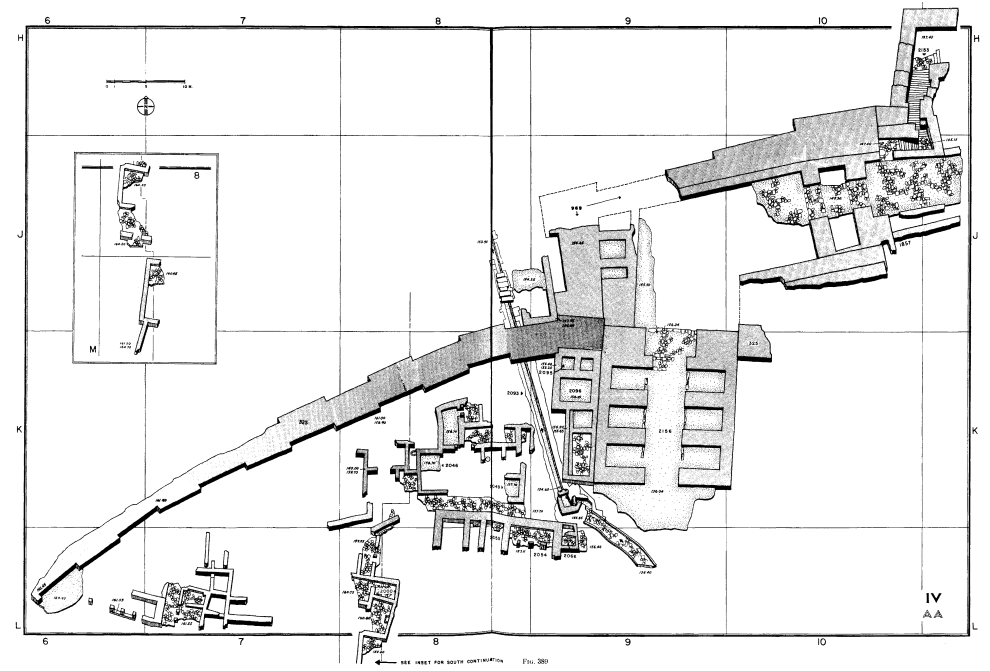 Figure 389
JW: Staircase is upper right - see closeup Loud (1948)  Figure 389 Closeup
Loud (1948)
Fig. 18:1Plan of Stratum IVA Ussishkin (2018) |
|
 Figure 31.3C
Staircase leading from the Iron II gate complex to a water system reservoir (Loud 1948: Fig. 389, Square H/10) is tilted 9°/000°. The staircase is built on a steep slope. (Fig. 31.3c). Marco et. al. (2006) Link to 3D scan of faulted staircase Link to 3D scan of faulted staircase (closeup) |
|
| Tilted Wall | Site 11
Fig. 31.2 Location map of deformed structures at Megiddo. Arrows indicate direction of shaking. Stars mark deformation that cannot be associated with a particular sense of movement. JW: Excavation Area Overlay in Red is approximate Modified from Marco et. al. (2006)
Fig. 18:1Plan of Stratum IVA Ussishkin (2018) |
|
|
|
| Fractured bedrock | Site 13
Fig. 31.2 Location map of deformed structures at Megiddo. Arrows indicate direction of shaking. Stars mark deformation that cannot be associated with a particular sense of movement. JW: Excavation Area Overlay in Red is approximate Modified from Marco et. al. (2006)
Fig. 18:1Plan of Stratum IVA Ussishkin (2018) |
|
|
|
| Fractured Walls | Site 14
Fig. 31.2 Location map of deformed structures at Megiddo. Arrows indicate direction of shaking. Stars mark deformation that cannot be associated with a particular sense of movement. JW: Excavation Area Overlay in Red is approximate Modified from Marco et. al. (2006)
Fig. 18:1Plan of Stratum IVA Ussishkin (2018) |
|
 Figure 77
Stratum III Storage Pit 1414 Lamon and Shipton (1939) |
|
| Destruction and Collapse Layer | Area H
Figure 5.25 Plan of Level H-5 Finkelstein et al. (2013 Vol. 1)
Fig. 5.1Excavation areas of the Tel Aviv University expedition Ussishkin (2018)
Megiddo: map of the site, showing excavation areasStern et al (2008 v. 5) |
|
Figure 5.27 The southern section of Area H with Level H-5 destruction in the centre of the picture (note the sloping down of the Level H-5 floor toward Installation 06/H/14 in the right) and Level H-7 floors, looking south. Finkelstein et al. (2013 Vol. 1)
Figure 5.28Destruction debris on Floor 98/H/62 of Level H-5, looking west. Finkelstein et al. (2013 Vol. 1) |
|
| Effect(s) | Location | Dating Info | Image(s) | Description |
|---|---|---|---|---|
| Fractured Walls | Site 14
Fig. 31.2 Location map of deformed structures at Megiddo. Arrows indicate direction of shaking. Stars mark deformation that cannot be associated with a particular sense of movement. JW: Excavation Area Overlay in Red is approximate Modified from Marco et. al. (2006)
Fig. 19:3Plan of Stratum III, after Ze'ev Herzog Ussishkin (2018) |
|
Figure 77 Stratum III Storage Pit 1414 Lamon and Shipton (1939) |
|
| Tilted Pillar | Site 15
Fig. 31.2 Location map of deformed structures at Megiddo. Arrows indicate direction of shaking. Stars mark deformation that cannot be associated with a particular sense of movement. JW: Excavation Area Overlay in Red is approximate Modified from Marco et. al. (2006)  Figure 72
Plan of Area A, Stratum III (cf. Fig, 115) Numbers in parentheses belong to Stratum III B JW: Building 1513 is in top left corner - see closeup Lamon and Shipton (1939)  Figure 72 Closeup
 Plan of Area A, Stratum III (cf. Fig, 115) Numbers in parentheses belong to Stratum III B Lamon and Shipton (1939)
Fig. 19:3Plan of Stratum III, after Ze'ev Herzog Ussishkin (2018) |
|
|
|
| Tilted and partially collapsed wall | Site 16
Fig. 31.2 Location map of deformed structures at Megiddo. Arrows indicate direction of shaking. Stars mark deformation that cannot be associated with a particular sense of movement. JW: Excavation Area Overlay in Red is approximate Modified from Marco et. al. (2006)
Figure 72Plan of Area A, Stratum III (cf. Fig, 115) Numbers in parentheses belong to Stratum III B JW: Building 1513 is in top left corner - see closeup Lamon and Shipton (1939)
Figure 72 Closeup Plan of Area A, Stratum III (cf. Fig, 115) Numbers in parentheses belong to Stratum III B Lamon and Shipton (1939)
Fig. 19:3Plan of Stratum III, after Ze'ev Herzog Ussishkin (2018) |
|
|
|
| Folded Wall | Site 17
Fig. 31.2 Location map of deformed structures at Megiddo. Arrows indicate direction of shaking. Stars mark deformation that cannot be associated with a particular sense of movement. JW: Excavation Area Overlay in Red is approximate Modified from Marco et. al. (2006)
Fig. 19:3Plan of Stratum III, after Ze'ev Herzog Ussishkin (2018) |
|
|
| Effect(s) | Location | Dating Info | Image(s) | Description |
|---|---|---|---|---|
| Fractured Walls | Site 1
Fig. 31.2 Location map of deformed structures at Megiddo. Arrows indicate direction of shaking. Stars mark deformation that cannot be associated with a particular sense of movement. JW: Excavation Area Overlay in Red is approximate Modified from Marco et. al. (2006) |
|
Figure 31.3D In Area J, the monumental walls of the Level J-4 temple are fractured in several places along their strike (Fig. 31.3d) as well as perpendicular to the strike (Figs. 31.3e-f). The overlying walls of the EB III temple 4050 are not fractured Marco et. al. (2006)
Figure 31.3EIn Area J, the monumental walls of the Level J-4 temple are fractured in several places along their strike (Fig. 31.3d) as well as perpendicular to the strike (Figs. 31.3e-f). The overlying walls of the EB III temple 4050 are not fractured Marco et. al. (2006)
Figure 31.3FIn Area J, the monumental walls of the Level J-4 temple are fractured in several places along their strike (Fig. 31.3d) as well as perpendicular to the strike (Figs. 31.3e-f). The overlying walls of the EB III temple 4050 are not fractured Marco et. al. (2006) |
|
| Fractured Walls | Site 1
Fig. 31.2 Location map of deformed structures at Megiddo. Arrows indicate direction of shaking. Stars mark deformation that cannot be associated with a particular sense of movement. JW: Excavation Area Overlay in Red is approximate Modified from Marco et. al. (2006)
Figure 15A suggested reconstruction for Stratum XVIII/Level J-4 Great Temple. JW: Wall 96/1 (with the fractures) is in the lower right (Courtesy of the Megiddo Expedition, the Institute of Archaeology, Tel Aviv University) Ussishkin (2015)
Figure 14The uncovered remains of Stratum XVIII/Level J-4 Great Temple JW: Dotted lines follow the suggested reconstruction in Fig. 15 above. This places fractured wall 96/1 in Square B-11 (Courtesy of the Megiddo Expedition, the Institute of Archaeology, Tel Aviv University) Ussishkin (2015)
Figure 1A plan of Megiddo, showing Area BB and Area J. JW: Round Altar 4017 is the area of interest with the fractured walls (Courtesy of the Megiddo Expedition, the Institute of Archaeology, Tel Aviv University) Ussishkin (2015)
Figure 16The sanctuary of the Great Temple, from the north JW: Use the round altar to find your way in the plans (Photo by P. Shrago; courtesy of the Megiddo Expedition, the Institute of Archaeology, Tel Aviv University) Ussishkin (2015)
Aerial Shot of the part of the Tel that includes Area Jclick on image to open a magnifiable image in a new tab Drone Photo by Jefferson Williams on 27 April 2023 (taken from outside the park) |
Level J-4 (Stratum XVIII) |
Figure 40.1 Wall 96/J/1 in Square H-10, looking east. Note fracture along the strike on the edge of the wall. Finkelstein et al. (2013 Vol. 3) |
|
| Fractured and Shifted Ashlar Stones | Site 3
Fig. 31.2 Location map of deformed structures at Megiddo. Arrows indicate direction of shaking. Stars mark deformation that cannot be associated with a particular sense of movement. JW: Excavation Area Overlay in Red is approximate Modified from Marco et. al. (2006) |
|
Figure 31.3H Extension cracks in the Late Bronze gate. Ashlar stones in courses in the middle of the walls (sandwiched between other courses) are fractured in opening mode. Horizontal sliding of the fragments occurred everywhere in the same direction, sub-parallel to N-S trend of the wall (Fig. 31.3h). The gate has no foundations, a fact that could have made it particularly vulnerable to seismic vibrations. Marco et. al. (2006)
Fig. 2.12The late Canaanite city-gate (Strata VIII-VII) Ussishkin (2011) Link to 3D scan of Canaanite Gate (east side) Link to 3D scan of Canaanite Gate (west side) |
|
| Fractured Roof Plate | Site 2
Fig. 31.2 Location map of deformed structures at Megiddo. Arrows indicate direction of shaking. Stars mark deformation that cannot be associated with a particular sense of movement. JW: Excavation Area Overlay in Red is approximate Modified from Marco et. al. (2006) |
|
|
|
| Folding and Liquefaction | Site 4
Fig. 31.2 Location map of deformed structures at Megiddo. Arrows indicate direction of shaking. Stars mark deformation that cannot be associated with a particular sense of movement. JW: Excavation Area Overlay in Red is approximate Modified from Marco et. al. (2006) |
|
Figure 31.3G Distorted and liquefied sand horizon in the western section of the Schumacher trench, excavated in the early 20th century. (Fig. 31.3g). Marco et. al. (2006) |
|
| Fractures | Site 5b
Fig. 31.2 Location map of deformed structures at Megiddo. Arrows indicate direction of shaking. Stars mark deformation that cannot be associated with a particular sense of movement. JW: Excavation Area Overlay in Red is approximate Modified from Marco et. al. (2006) |
Date of Level K-4
|
|
|
| Folded Wall | Site 5a
Fig. 31.2 Location map of deformed structures at Megiddo. Arrows indicate direction of shaking. Stars mark deformation that cannot be associated with a particular sense of movement. JW: Excavation Area Overlay in Red is approximate Modified from Marco et. al. (2006) |
|
Figure 31.3I A warped wall trending 220° in Area K is tilted to both sides 12°-15°. (Fig. 31.3i.) Marco et. al. (2006)
Figure 2LA deformed, wall in Megiddo, part of a Late Iron Age, 8th century BC building (Marco et al., 2006). Site 10 in Fig. 1 Marco (2008) |
|
| Collapsed Walls | Site 6
Fig. 31.2 Location map of deformed structures at Megiddo. Arrows indicate direction of shaking. Stars mark deformation that cannot be associated with a particular sense of movement. JW: Excavation Area Overlay in Red is approximate Modified from Marco et. al. (2006) |
|
|
|
| Tilted Walls | Site 8
Fig. 31.2 Location map of deformed structures at Megiddo. Arrows indicate direction of shaking. Stars mark deformation that cannot be associated with a particular sense of movement. JW: Excavation Area Overlay in Red is approximate Modified from Marco et. al. (2006) |
|
|
|
| Tilted Floor | Site 10
Fig. 31.2 Location map of deformed structures at Megiddo. Arrows indicate direction of shaking. Stars mark deformation that cannot be associated with a particular sense of movement. JW: Excavation Area Overlay in Red is approximate Modified from Marco et. al. (2006) |
|
Figure 31.3A The south-western corner of Palace 6000 (Area L, Squares D/5, E/4-5) is tilted 3°-5° (top dipping to 250°-260° — Fig. 31.3a). In the northern baulk of Squares D-E/4, a white layer which belongs to the palace's floor make-up is also tilted. Immediately to the east, in the northern section of Square E/4, there are two fissures, each about 10-15 cm wide in the same floor make-up. The fissures are filled with grey unconsolidated soil that contains a few ceramic fragments. The white make-up for Floor 98/L/59 and plaster Floor 98/L/120 — both of the Level L-2 stables — are horizontal Marco et. al. (2006)
Figure 2NAn episode of tilting is exhibited by an angle between tilted stone floor and an overlying horizontal plaster floor in Megiddo. The stratigraphy shows that the tilting postdates the lower and predates the upper floor, but the precise time of construction is archaeologically indistinguishable. Both were built in the Iron Age II (9th century BC). Since the upper floor remained perfectly horizontal in the last 3 millennia we assume that the tilting of its precedent was rapid and exceptional, probably associated with an earthquake (Marco et al., 2006). Site 10 in Fig. 1 Marco (2008) |
|
| Tilted Columns | Site 7
Fig. 31.2 Location map of deformed structures at Megiddo. Arrows indicate direction of shaking. Stars mark deformation that cannot be associated with a particular sense of movement. JW: Excavation Area Overlay in Red is approximate Modified from Marco et. al. (2006) |
|
Figure 31.3B A group of six pillars in Building 1A (Lamon and Shipton 1939: Fig. 6) are all tilted 8°-11° to the west (265°-295°). (Fig. 31.3b). Marco et. al. (2006)
Figure 2MLeaning Iron Age II (9th century BC) columns in Megiddo (Marco et al., 2006). The supports at the bottom are modern. Site 10 in Fig. 1 Marco (2008)
View of the three tilted pillar using digital theodolite with theodolite orinted flat
Digital Theodolite Photo by Jefferson Williams on 27 April 2023
View of the three tilted pillar using digital theodolite to estimate tilt on central Pillar. Tilt estimate is 8.2°.
Digital Theodolite Photo by Jefferson Williams on 27 April 2023
Tilt direction estimate using iPhone Compass and square wood dowel spanning two of the columns. Direction estimate of Azimuth is 288°.
Photo by Jefferson Williams on 27 April 2023 Link to 3D scan of 3 tilted pillars (Site 7) |
|
| Collapsed Walls | Site 9
Fig. 31.2 Location map of deformed structures at Megiddo. Arrows indicate direction of shaking. Stars mark deformation that cannot be associated with a particular sense of movement. JW: Excavation Area Overlay in Red is approximate Modified from Marco et. al. (2006) |
|
|
|
| Tilted and Faulted Staircase | Site 12
Fig. 31.2 Location map of deformed structures at Megiddo. Arrows indicate direction of shaking. Stars mark deformation that cannot be associated with a particular sense of movement. JW: Excavation Area Overlay in Red is approximate Modified from Marco et. al. (2006)
Figure 389JW: Staircase is upper right - see closeup Loud (1948)
Figure 389 CloseupLoud (1948) |
|
Figure 31.3C Staircase leading from the Iron II gate complex to a water system reservoir (Loud 1948: Fig. 389, Square H/10) is tilted 9°/000°. The staircase is built on a steep slope. (Fig. 31.3c). Marco et. al. (2006) Link to 3D scan of faulted staircase Link to 3D scan of faulted staircase (closeup) |
|
| Tilted Wall | Site 11
Fig. 31.2 Location map of deformed structures at Megiddo. Arrows indicate direction of shaking. Stars mark deformation that cannot be associated with a particular sense of movement. JW: Excavation Area Overlay in Red is approximate Modified from Marco et. al. (2006) |
|
|
|
| Fractured bedrock | Site 13
Fig. 31.2 Location map of deformed structures at Megiddo. Arrows indicate direction of shaking. Stars mark deformation that cannot be associated with a particular sense of movement. JW: Excavation Area Overlay in Red is approximate Modified from Marco et. al. (2006) |
|
|
|
| Destruction and Collapse Layer | Area H
Figure 5.25 Plan of Level H-5 Finkelstein et al. (2013 Vol. 1) |
|
Figure 5.27 The southern section of Area H with Level H-5 destruction in the centre of the picture (note the sloping down of the Level H-5 floor toward Installation 06/H/14 in the right) and Level H-7 floors, looking south. Finkelstein et al. (2013 Vol. 1)
Figure 5.28Destruction debris on Floor 98/H/62 of Level H-5, looking west. Finkelstein et al. (2013 Vol. 1) |
|
| Fractured Walls | Site 14
Fig. 31.2 Location map of deformed structures at Megiddo. Arrows indicate direction of shaking. Stars mark deformation that cannot be associated with a particular sense of movement. JW: Excavation Area Overlay in Red is approximate Modified from Marco et. al. (2006) |
|
Figure 77 Stratum III Storage Pit 1414 Lamon and Shipton (1939) |
|
| Tilted Pillar | Site 15
Fig. 31.2 Location map of deformed structures at Megiddo. Arrows indicate direction of shaking. Stars mark deformation that cannot be associated with a particular sense of movement. JW: Excavation Area Overlay in Red is approximate Modified from Marco et. al. (2006)
Figure 72Plan of Area A, Stratum III (cf. Fig, 115) Numbers in parentheses belong to Stratum III B JW: Building 1513 is in top left corner - see closeup Lamon and Shipton (1939)
Figure 72 Closeup Plan of Area A, Stratum III (cf. Fig, 115) Numbers in parentheses belong to Stratum III B Lamon and Shipton (1939) |
|
|
|
| Tilted and partially collapsed wall | Site 16
Fig. 31.2 Location map of deformed structures at Megiddo. Arrows indicate direction of shaking. Stars mark deformation that cannot be associated with a particular sense of movement. JW: Excavation Area Overlay in Red is approximate Modified from Marco et. al. (2006)
Figure 72Plan of Area A, Stratum III (cf. Fig, 115) Numbers in parentheses belong to Stratum III B JW: Building 1513 is in top left corner - see closeup Lamon and Shipton (1939)
Figure 72 Closeup Plan of Area A, Stratum III (cf. Fig, 115) Numbers in parentheses belong to Stratum III B Lamon and Shipton (1939) |
|
|
|
| Folded Wall | Site 17
Fig. 31.2 Location map of deformed structures at Megiddo. Arrows indicate direction of shaking. Stars mark deformation that cannot be associated with a particular sense of movement. JW: Excavation Area Overlay in Red is approximate Modified from Marco et. al. (2006) |
|
|
- Modified by JW from Fig. 31.2 of Marco et. al. (2006)
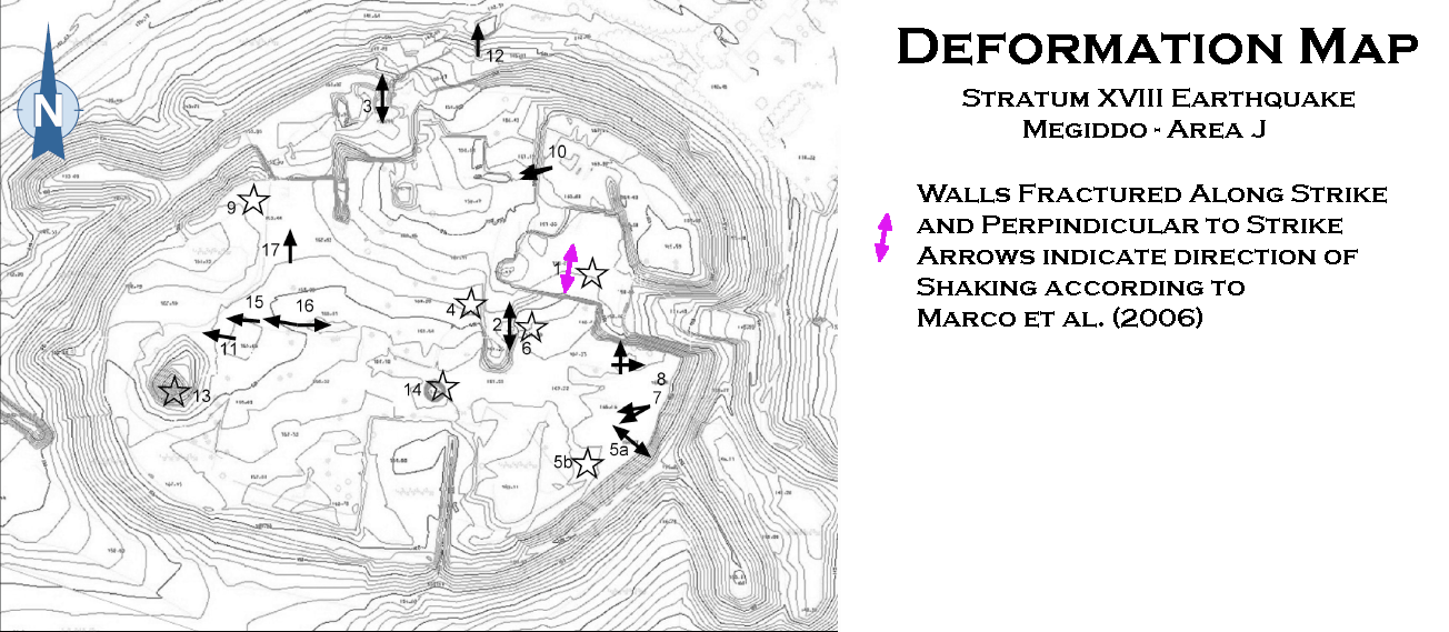 Deformation Map
Modified by JW from Fig. 31.2 of Marco et. al. (2006)
- Modified by JW from Fig. 31.2 of Marco et. al. (2006)
 Deformation Map
Modified by JW from Fig. 31.2 of Marco et. al. (2006)
- Modified by JW from Fig. 31.2 of Marco et. al. (2006)
 Deformation Map
Modified by JW from Fig. 31.2 of Marco et. al. (2006)
- Modified by JW from Fig. 31.2 of Marco et. al. (2006)
 Deformation Map
Modified by JW from Fig. 31.2 of Marco et. al. (2006)
- Modified by JW from Fig. 31.2 of Marco et. al. (2006)
 Deformation Map
Modified by JW from Fig. 31.2 of Marco et. al. (2006)
- Modified by JW from Fig. 31.2 of Marco et. al. (2006)
 Deformation Map
Modified by JW from Fig. 31.2 of Marco et. al. (2006)
-
Earthquake Archeological Effects chart
of Rodríguez-Pascua et al (2013: 221-224)
 Earthquake Archeological Effects (EAE)
Rodríguez-Pascua et al (2013: 221-224)
| Effect(s) | Location | Dating Info | Image(s) | Description | Intensity |
|---|---|---|---|---|---|
| Fractured Walls (Displaced Walls) | Site 1
Fig. 31.2 Location map of deformed structures at Megiddo. Arrows indicate direction of shaking. Stars mark deformation that cannot be associated with a particular sense of movement. JW: Excavation Area Overlay in Red is approximate Modified from Marco et. al. (2006)
Fig. 3Plan of the Great Temple of Level J-4. (Illustration by M. J. Adams) Sapir-Hen et al. (2022)
Fig. 2.7The Great Temple of Stratum XVIII; a reconstructed plan. Ussishkin (2011) |
|
Figure 31.3D In Area J, the monumental walls of the Level J-4 temple are fractured in several places along their strike (Fig. 31.3d) as well as perpendicular to the strike (Figs. 31.3e-f). The overlying walls of the EB III temple 4050 are not fractured Marco et. al. (2006)
Figure 31.3EIn Area J, the monumental walls of the Level J-4 temple are fractured in several places along their strike (Fig. 31.3d) as well as perpendicular to the strike (Figs. 31.3e-f). The overlying walls of the EB III temple 4050 are not fractured Marco et. al. (2006)
Figure 31.3FIn Area J, the monumental walls of the Level J-4 temple are fractured in several places along their strike (Fig. 31.3d) as well as perpendicular to the strike (Figs. 31.3e-f). The overlying walls of the EB III temple 4050 are not fractured Marco et. al. (2006) |
|
VII+ |
| Fractured Walls (Displaced Walls) | Site 1
Fig. 31.2 Location map of deformed structures at Megiddo. Arrows indicate direction of shaking. Stars mark deformation that cannot be associated with a particular sense of movement. JW: Excavation Area Overlay in Red is approximate Modified from Marco et. al. (2006)
Fig. 3Plan of the Great Temple of Level J-4. (Illustration by M. J. Adams) Sapir-Hen et al. (2022)
Fig. 2.7The Great Temple of Stratum XVIII; a reconstructed plan. Ussishkin (2011)
Figure 15A suggested reconstruction for Stratum XVIII/Level J-4 Great Temple. JW: Wall 96/1 (with the fractures) is in the lower right (Courtesy of the Megiddo Expedition, the Institute of Archaeology, Tel Aviv University) Ussishkin (2015)
Figure 14The uncovered remains of Stratum XVIII/Level J-4 Great Temple JW: Dotted lines follow the suggested reconstruction in Fig. 15 above. This places fractured wall 96/1 in Square B-11 (Courtesy of the Megiddo Expedition, the Institute of Archaeology, Tel Aviv University) Ussishkin (2015)
Figure 1A plan of Megiddo, showing Area BB and Area J. JW: Round Altar 4017 is the area of interest with the fractured walls (Courtesy of the Megiddo Expedition, the Institute of Archaeology, Tel Aviv University) Ussishkin (2015)
Figure 16The sanctuary of the Great Temple, from the north JW: Use the round altar to find your way in the plans (Photo by P. Shrago; courtesy of the Megiddo Expedition, the Institute of Archaeology, Tel Aviv University) Ussishkin (2015)
Aerial Shot of the part of the Tel that includes Area Jclick on image to open a magnifiable image in a new tab Drone Photo by Jefferson Williams on 27 April 2023 (taken from outside the park) |
Level J-4 (Stratum XVIII) |
Figure 40.1 Wall 96/J/1 in Square H-10, looking east. Note fracture along the strike on the edge of the wall. Finkelstein et al. (2013 Vol. 3) |
|
VII+ |
-
Earthquake Archeological Effects chart
of Rodríguez-Pascua et al (2013: 221-224)
Earthquake Archeological Effects (EAE)
Rodríguez-Pascua et al (2013: 221-224)
| Effect(s) | Location | Dating Info | Image(s) | Description | Intensity |
|---|---|---|---|---|---|
| Fractured and Shifted Ashlar Stones (displaced masonry blocks) | Site 3
Fig. 31.2 Location map of deformed structures at Megiddo. Arrows indicate direction of shaking. Stars mark deformation that cannot be associated with a particular sense of movement. JW: Excavation Area Overlay in Red is approximate Modified from Marco et. al. (2006) |
|
Figure 31.3H Extension cracks in the Late Bronze gate. Ashlar stones in courses in the middle of the walls (sandwiched between other courses) are fractured in opening mode. Horizontal sliding of the fragments occurred everywhere in the same direction, sub-parallel to N-S trend of the wall (Fig. 31.3h). The gate has no foundations, a fact that could have made it particularly vulnerable to seismic vibrations. Marco et. al. (2006)
Fig. 2.12The late Canaanite city-gate (Strata VIII-VII) Ussishkin (2011)
LB city gate in area AA. Stern et al (1993 v. 3) Link to 3D scan of Canaanite Gate (east side) Link to 3D scan of Canaanite Gate (west side) |
|
VIII+ |
| Fractured Roof Plate (displaced walls) | Site 2
Fig. 31.2 Location map of deformed structures at Megiddo. Arrows indicate direction of shaking. Stars mark deformation that cannot be associated with a particular sense of movement. JW: Excavation Area Overlay in Red is approximate Modified from Marco et. al. (2006) |
|
|
VII+ |
-
Earthquake Archeological Effects chart
of Rodríguez-Pascua et al (2013: 221-224)
Earthquake Archeological Effects (EAE)
Rodríguez-Pascua et al (2013: 221-224)
| Effect(s) | Location | Dating Info | Image(s) | Description | Intensity |
|---|---|---|---|---|---|
| Folding and Liquefaction | Site 4
Fig. 31.2 Location map of deformed structures at Megiddo. Arrows indicate direction of shaking. Stars mark deformation that cannot be associated with a particular sense of movement. JW: Excavation Area Overlay in Red is approximate Modified from Marco et. al. (2006) |
|
Figure 31.3G Distorted and liquefied sand horizon in the western section of the Schumacher trench, excavated in the early 20th century. (Fig. 31.3g). Marco et. al. (2006) |
|
VII+ |
| Fractures (penetrative fractures) | Area K - aka Site 5b
Fig. 31.2 Location map of deformed structures at Megiddo. Arrows indicate direction of shaking. Stars mark deformation that cannot be associated with a particular sense of movement. JW: Excavation Area Overlay in Red is approximate Modified from Marco et. al. (2006)
Fig. 5.1Excavation areas of the Tel Aviv University expedition Ussishkin (2018)
Megiddo: map of the site, showing excavation areasStern et al (2008 v. 5)
Fig. 1Aerial view of Megiddo, looking north, indicating the excavation areas discussed in the article (courtesy of the Megiddo Expedition). Kleiman et al. (2023)
Fig. 24Evidence for the fierce conflagration of Stratum VIA at Megiddo; areas with evidence for burials/human remains under collapse are indicated. Though the stratigraphic situation in Area BB is fuzzy, signs of a violent event were found there too. Kleiman et al. (2023)
Figure 7.7Plan of Level K-4 Finkelstein et al. (2006) |
Date of Level K-4
|
|
VI+ | |
| Folded Wall | Area K aka Site 5a
Fig. 31.2 Location map of deformed structures at Megiddo. Arrows indicate direction of shaking. Stars mark deformation that cannot be associated with a particular sense of movement. JW: Excavation Area Overlay in Red is approximate Modified from Marco et. al. (2006)
Fig. 5.1Excavation areas of the Tel Aviv University expedition Ussishkin (2018)
Megiddo: map of the site, showing excavation areasStern et al (2008 v. 5)
Fig. 1Aerial view of Megiddo, looking north, indicating the excavation areas discussed in the article (courtesy of the Megiddo Expedition). Kleiman et al. (2023)
Fig. 24Evidence for the fierce conflagration of Stratum VIA at Megiddo; areas with evidence for burials/human remains under collapse are indicated. Though the stratigraphic situation in Area BB is fuzzy, signs of a violent event were found there too. Kleiman et al. (2023)
Figure 7.7Plan of Level K-4 Finkelstein et al. (2006) |
|
Figure 31.3I A warped wall trending 220° in Area K is tilted to both sides 12°-15°. (Fig. 31.3i.) Marco et. al. (2006)
Figure 2LA deformed, wall in Megiddo, part of a Late Iron Age, 8th century BC building (Marco et al., 2006). Site 10 in Fig. 1 Marco (2008) |
|
VII+ |
|
Area K - Central Courtyard - 00/10
Fig. 5.1 Excavation areas of the Tel Aviv University expedition Ussishkin (2018)
Megiddo: map of the site, showing excavation areasStern et al (2008 v. 5)
Fig. 1Aerial view of Megiddo, looking north, indicating the excavation areas discussed in the article (courtesy of the Megiddo Expedition). Kleiman et al. (2023)
Fig. 24Evidence for the fierce conflagration of Stratum VIA at Megiddo; areas with evidence for burials/human remains under collapse are indicated. Though the stratigraphic situation in Area BB is fuzzy, signs of a violent event were found there too. Kleiman et al. (2023)
Figure 7.7Plan of Level K-4 Finkelstein et al. (2006) |
Fig. 22
Fig. 22 Skeletal remains in articulation in Baulk N–O/11 (Locus 04/K/38) in Area K. Note that the initial exposure of the individual was under Locus 04/K/26 (courtesy of the Megiddo Expedition, previously unpublished photo) Kleiman et al. (2023) |
|
|
|
|
Area K - Room 98/70
Fig. 5.1 Excavation areas of the Tel Aviv University expedition Ussishkin (2018)
Megiddo: map of the site, showing excavation areasStern et al (2008 v. 5)
Fig. 1Aerial view of Megiddo, looking north, indicating the excavation areas discussed in the article (courtesy of the Megiddo Expedition). Kleiman et al. (2023)
Fig. 24Evidence for the fierce conflagration of Stratum VIA at Megiddo; areas with evidence for burials/human remains under collapse are indicated. Though the stratigraphic situation in Area BB is fuzzy, signs of a violent event were found there too. Kleiman et al. (2023)
Figure 7.7Plan of Level K-4 Finkelstein et al. (2006) |
Fig. 7.11
Figure 7.11 Destruction layer of Level K-4 in Square O/9. Finkelstein et al. (2006) |
|
|
|
|
Area K - Room 98/77
Fig. 5.1 Excavation areas of the Tel Aviv University expedition Ussishkin (2018)
Megiddo: map of the site, showing excavation areasStern et al (2008 v. 5)
Fig. 1Aerial view of Megiddo, looking north, indicating the excavation areas discussed in the article (courtesy of the Megiddo Expedition). Kleiman et al. (2023)
Fig. 24Evidence for the fierce conflagration of Stratum VIA at Megiddo; areas with evidence for burials/human remains under collapse are indicated. Though the stratigraphic situation in Area BB is fuzzy, signs of a violent event were found there too. Kleiman et al. (2023)
Figure 7.7Plan of Level K-4 Finkelstein et al. (2006) |
Fig. 7.10
Figure 7.10 Destruction layer of Level K-4 in the southern baulk of Square N/11. Note collapse of mudbricks and vessels. Finkelstein et al. (2006) |
|
|
|
|
Area K - Room 98/46
Fig. 5.1 Excavation areas of the Tel Aviv University expedition Ussishkin (2018)
Megiddo: map of the site, showing excavation areasStern et al (2008 v. 5)
Fig. 1Aerial view of Megiddo, looking north, indicating the excavation areas discussed in the article (courtesy of the Megiddo Expedition). Kleiman et al. (2023)
Fig. 24Evidence for the fierce conflagration of Stratum VIA at Megiddo; areas with evidence for burials/human remains under collapse are indicated. Though the stratigraphic situation in Area BB is fuzzy, signs of a violent event were found there too. Kleiman et al. (2023)
Figure 7.7Plan of Level K-4 Finkelstein et al. (2006) |
|
|
||
|
Area K - Rooms 00/51 and 00/45
Fig. 5.1 Excavation areas of the Tel Aviv University expedition Ussishkin (2018)
Megiddo: map of the site, showing excavation areasStern et al (2008 v. 5)
Fig. 1Aerial view of Megiddo, looking north, indicating the excavation areas discussed in the article (courtesy of the Megiddo Expedition). Kleiman et al. (2023)
Fig. 24Evidence for the fierce conflagration of Stratum VIA at Megiddo; areas with evidence for burials/human remains under collapse are indicated. Though the stratigraphic situation in Area BB is fuzzy, signs of a violent event were found there too. Kleiman et al. (2023)
Figure 7.7Plan of Level K-4 Finkelstein et al. (2006) |
Figure 7.13 Room 00/K/45 of Level K-4, looking west Finkelstein et al. (2006) |
|
|
|
|
Area K - Outside Building 00/10
Fig. 5.1 Excavation areas of the Tel Aviv University expedition Ussishkin (2018)
Megiddo: map of the site, showing excavation areasStern et al (2008 v. 5)
Fig. 1Aerial view of Megiddo, looking north, indicating the excavation areas discussed in the article (courtesy of the Megiddo Expedition). Kleiman et al. (2023)
Fig. 24Evidence for the fierce conflagration of Stratum VIA at Megiddo; areas with evidence for burials/human remains under collapse are indicated. Though the stratigraphic situation in Area BB is fuzzy, signs of a violent event were found there too. Kleiman et al. (2023)
Figure 7.7Plan of Level K-4 Finkelstein et al. (2006) |
|
|
||
|
Area K - Activity area 98/45
Fig. 5.1 Excavation areas of the Tel Aviv University expedition Ussishkin (2018)
Megiddo: map of the site, showing excavation areasStern et al (2008 v. 5)
Fig. 1Aerial view of Megiddo, looking north, indicating the excavation areas discussed in the article (courtesy of the Megiddo Expedition). Kleiman et al. (2023)
Fig. 24Evidence for the fierce conflagration of Stratum VIA at Megiddo; areas with evidence for burials/human remains under collapse are indicated. Though the stratigraphic situation in Area BB is fuzzy, signs of a violent event were found there too. Kleiman et al. (2023)
Figure 7.7Plan of Level K-4 Finkelstein et al. (2006) |
|
|
||
| Collapsed Walls | Area M aka Site 6
Fig. 31.2 Location map of deformed structures at Megiddo. Arrows indicate direction of shaking. Stars mark deformation that cannot be associated with a particular sense of movement. JW: Excavation Area Overlay in Red is approximate Modified from Marco et. al. (2006)
Fig. 5.1Excavation areas of the Tel Aviv University expedition Ussishkin (2018)
Megiddo: map of the site, showing excavation areasStern et al (2008 v. 5)
Fig. 24Evidence for the fierce conflagration of Stratum VIA at Megiddo; areas with evidence for burials/human remains under collapse are indicated. Though the stratigraphic situation in Area BB is fuzzy, signs of a violent event were found there too. Kleiman et al. (2023)
Figure 5.1Location of Area M vis-a-vis the central sector of Schumacher's trench. Plan. (based on Loud 1948: Fig. 415) Finkelstein et al. (2006)
Figure 5.1Location of Area M vis-a-vis the central sector of Schumacher's trench. Aerial view 1998, looking north. Finkelstein et al. (2006)
Figure 4.20Plan of Level M-4. Finkelstein et al. (2013 Vol. 1) |
|
|
VIII+ | |
|
Area M - Square M/9
Fig. 5.1 Excavation areas of the Tel Aviv University expedition Ussishkin (2018)
Megiddo: map of the site, showing excavation areasStern et al (2008 v. 5)
Fig. 24Evidence for the fierce conflagration of Stratum VIA at Megiddo; areas with evidence for burials/human remains under collapse are indicated. Though the stratigraphic situation in Area BB is fuzzy, signs of a violent event were found there too. Kleiman et al. (2023)
Figure 5.1Location of Area M vis-a-vis the central sector of Schumacher's trench. Plan. (based on Loud 1948: Fig. 415) Finkelstein et al. (2006)
Figure 5.1Location of Area M vis-a-vis the central sector of Schumacher's trench. Aerial view 1998, looking north. Finkelstein et al. (2006)
Figure 4.20Plan of Level M-4. Finkelstein et al. (2013 Vol. 1) |
|
|
||
|
Area M
Fig. 5.1 Excavation areas of the Tel Aviv University expedition Ussishkin (2018)
Megiddo: map of the site, showing excavation areasStern et al (2008 v. 5)
Fig. 24Evidence for the fierce conflagration of Stratum VIA at Megiddo; areas with evidence for burials/human remains under collapse are indicated. Though the stratigraphic situation in Area BB is fuzzy, signs of a violent event were found there too. Kleiman et al. (2023)
Figure 5.1Location of Area M vis-a-vis the central sector of Schumacher's trench. Plan. (based on Loud 1948: Fig. 415) Finkelstein et al. (2006)
Figure 5.1Location of Area M vis-a-vis the central sector of Schumacher's trench. Aerial view 1998, looking north. Finkelstein et al. (2006)
Figure 4.20Plan of Level M-4. Finkelstein et al. (2013 Vol. 1) |
|
|
||
|
Area Q
Fig. 1 Aerial view of Megiddo, looking north, indicating the excavation areas discussed in the article (courtesy of the Megiddo Expedition). Kleiman et al. (2023)
Fig. 10Plan of Level Q-7a; shaded walls signify elements built in a previous occupational phase and reused (courtesy of the Megiddo Expedition). Kleiman et al. (2023)
Fig. 24Evidence for the fierce conflagration of Stratum VIA at Megiddo; areas with evidence for burials/human remains under collapse are indicated. Though the stratigraphic situation in Area BB is fuzzy, signs of a violent event were found there too. Kleiman et al. (2023) |
|
Fig. 3 A typical accumulation of the destruction debris of Stratum VIA. The black line at the bottom of the debris signifies the floor; Square I/2 in Area Q, looking north (courtesy of the Megiddo Expedition). Kleiman et al. (2023)
Fig. 12A view of the destruction of the Level Q-7 (Stratum VIA) city in Squares H/4–5, looking south-east (courtesy of the Megiddo Expedition). Kleiman et al. (2023) |
|
|
| Human Remains | Area Q - Baulk H–I/4 on a floor to the north-east of Building 16/Q/48 of Level Q-7a, directly below the destruction debris (Locus 16/Q/79)
Fig. 1 Aerial view of Megiddo, looking north, indicating the excavation areas discussed in the article (courtesy of the Megiddo Expedition). Kleiman et al. (2023)
Fig. 10Plan of Level Q-7a; shaded walls signify elements built in a previous occupational phase and reused (courtesy of the Megiddo Expedition). Kleiman et al. (2023) |
|
Fig. 14 Remains of an individual found in Locus 16/Q/79:
(courtesy of the Megiddo Expedition) Kleiman et al. (2023) |
|
VIII+ |
|
many other places across the site
Fig. 24Evidence for the fierce conflagration of Stratum VIA at Megiddo; areas with evidence for burials/human remains under collapse are indicated. Though the stratigraphic situation in Area BB is fuzzy, signs of a violent event were found there too. Kleiman et al. (2023) |
|
|
-
Earthquake Archeological Effects chart
of Rodríguez-Pascua et al (2013: 221-224)
Earthquake Archeological Effects (EAE)
Rodríguez-Pascua et al (2013: 221-224)
| Effect(s) | Location | Dating Info | Image(s) | Description | Intensity |
|---|---|---|---|---|---|
| Tilted Walls | Site 8
Fig. 31.2 Location map of deformed structures at Megiddo. Arrows indicate direction of shaking. Stars mark deformation that cannot be associated with a particular sense of movement. JW: Excavation Area Overlay in Red is approximate Modified from Marco et. al. (2006)
Fig. 15:2Plan of Stratum VA-IVB Ussishkin (2018)
Megiddo: plan of the city and main buildings in strata VA-IVB and IVA.Stern et al (1993 v. 3) |
|
|
VI+ | |
| Tilted Floor | Site 10
Fig. 31.2 Location map of deformed structures at Megiddo. Arrows indicate direction of shaking. Stars mark deformation that cannot be associated with a particular sense of movement. JW: Excavation Area Overlay in Red is approximate Modified from Marco et. al. (2006)
Fig. 15:2Plan of Stratum VA-IVB Ussishkin (2018)
Megiddo: plan of the city and main buildings in strata VA-IVB and IVA.Stern et al (1993 v. 3) |
|
Figure 31.3A The south-western corner of Palace 6000 (Area L, Squares D/5, E/4-5) is tilted 3°-5° (top dipping to 250°-260° — Fig. 31.3a). In the northern baulk of Squares D-E/4, a white layer which belongs to the palace's floor make-up is also tilted. Immediately to the east, in the northern section of Square E/4, there are two fissures, each about 10-15 cm wide in the same floor make-up. The fissures are filled with grey unconsolidated soil that contains a few ceramic fragments. The white make-up for Floor 98/L/59 and plaster Floor 98/L/120 — both of the Level L-2 stables — are horizontal Marco et. al. (2006)
Figure 2NAn episode of tilting is exhibited by an angle between tilted stone floor and an overlying horizontal plaster floor in Megiddo. The stratigraphy shows that the tilting postdates the lower and predates the upper floor, but the precise time of construction is archaeologically indistinguishable. Both were built in the Iron Age II (9th century BC). Since the upper floor remained perfectly horizontal in the last 3 millennia we assume that the tilting of its precedent was rapid and exceptional, probably associated with an earthquake (Marco et al., 2006). Site 10 in Fig. 1 Marco (2008) |
|
VIII+ |
| Tilted Columns (treated like tilted walls) | Site 7
Fig. 31.2 Location map of deformed structures at Megiddo. Arrows indicate direction of shaking. Stars mark deformation that cannot be associated with a particular sense of movement. JW: Excavation Area Overlay in Red is approximate Modified from Marco et. al. (2006)
Fig. 15:2Plan of Stratum VA-IVB Ussishkin (2018)
Megiddo: plan of the city and main buildings in strata VA-IVB and IVA.Stern et al (1993 v. 3) |
|
Figure 31.3B A group of six pillars in Building 1A (Lamon and Shipton 1939: Fig. 6) are all tilted 8°-11° to the west (265°-295°). (Fig. 31.3b). Marco et. al. (2006)
Figure 2MLeaning Iron Age II (9th century BC) columns in Megiddo (Marco et al., 2006). The supports at the bottom are modern. Site 10 in Fig. 1 Marco (2008)
View of the three tilted pillar using digital theodolite with theodolite orinted flat
Digital Theodolite Photo by Jefferson Williams on 27 April 2023
View of the three tilted pillar using digital theodolite to estimate tilt on central Pillar. Tilt estimate is 8.2°.
Digital Theodolite Photo by Jefferson Williams on 27 April 2023
Tilt direction estimate using iPhone Compass and square wood dowel spanning two of the columns. Direction estimate of Azimuth is 288°.
Photo by Jefferson Williams on 27 April 2023 Link to 3D scan of 3 tilted pillars (Site 7) |
|
VI+ |
| Collapsed Walls | Site 9
Fig. 31.2 Location map of deformed structures at Megiddo. Arrows indicate direction of shaking. Stars mark deformation that cannot be associated with a particular sense of movement. JW: Excavation Area Overlay in Red is approximate Modified from Marco et. al. (2006) |
|
|
VIII+ |
-
Earthquake Archeological Effects chart
of Rodríguez-Pascua et al (2013: 221-224)
Earthquake Archeological Effects (EAE)
Rodríguez-Pascua et al (2013: 221-224)
| Effect(s) | Location | Dating Info | Image(s) | Description | Intensity |
|---|---|---|---|---|---|
| Tilted and Faulted Staircase (Fractures folds and popups on pavements) | Site 12
Fig. 31.2 Location map of deformed structures at Megiddo. Arrows indicate direction of shaking. Stars mark deformation that cannot be associated with a particular sense of movement. JW: Excavation Area Overlay in Red is approximate Modified from Marco et. al. (2006)
Figure 389JW: Staircase is upper right - see closeup Loud (1948)
Figure 389 CloseupLoud (1948) |
|
Figure 31.3C Staircase leading from the Iron II gate complex to a water system reservoir (Loud 1948: Fig. 389, Square H/10) is tilted 9°/000°. The staircase is built on a steep slope. (Fig. 31.3c). Marco et. al. (2006) Link to 3D scan of faulted staircase Link to 3D scan of faulted staircase (closeup) |
|
VI+ |
| Tilted Wall | Site 11
Fig. 31.2 Location map of deformed structures at Megiddo. Arrows indicate direction of shaking. Stars mark deformation that cannot be associated with a particular sense of movement. JW: Excavation Area Overlay in Red is approximate Modified from Marco et. al. (2006)
Fig. 18:1Plan of Stratum IVA Ussishkin (2018) |
|
|
VI+ | |
| Fractured bedrock (fractures, folds, and popups on irregular pavements) | Site 13
Fig. 31.2 Location map of deformed structures at Megiddo. Arrows indicate direction of shaking. Stars mark deformation that cannot be associated with a particular sense of movement. JW: Excavation Area Overlay in Red is approximate Modified from Marco et. al. (2006)
Fig. 18:1Plan of Stratum IVA Ussishkin (2018) |
|
|
VI+ | |
| Fractured Walls (displaced wallls ?) | Site 14
Fig. 31.2 Location map of deformed structures at Megiddo. Arrows indicate direction of shaking. Stars mark deformation that cannot be associated with a particular sense of movement. JW: Excavation Area Overlay in Red is approximate Modified from Marco et. al. (2006)
Fig. 18:1Plan of Stratum IVA Ussishkin (2018) |
|
Figure 77 Stratum III Storage Pit 1414 Lamon and Shipton (1939) |
|
VII+ |
| Destruction and Collapse Layer (collapsed walls) | Area H
Figure 5.25 Plan of Level H-5 Finkelstein et al. (2013 Vol. 1)
Fig. 5.1Excavation areas of the Tel Aviv University expedition Ussishkin (2018)
Megiddo: map of the site, showing excavation areasStern et al (2008 v. 5) |
|
Figure 5.27 The southern section of Area H with Level H-5 destruction in the centre of the picture (note the sloping down of the Level H-5 floor toward Installation 06/H/14 in the right) and Level H-7 floors, looking south. Finkelstein et al. (2013 Vol. 1)
Figure 5.28Destruction debris on Floor 98/H/62 of Level H-5, looking west. Finkelstein et al. (2013 Vol. 1) |
|
VIII+ |
the destruction of this city was not complete and certain parts of the mound did not show evidence of destruction by fire (Finkelstein 2009: 117).The fractured bedrock lacks a reliable terminus ante quem and may not have been fractured by seismic activity. If it was fractured by seismic activity, one would expect city-wide collapse as it suggests an Intensity of IX or higher. If Level H-5 destruction was due to an earthquake, this evidence requires a minimum Intensity of VIII (8) when using the Earthquake Archeological Effects chart of Rodríguez-Pascua et al (2013: 221-224).
-
Earthquake Archeological Effects chart
of Rodríguez-Pascua et al (2013: 221-224)
Earthquake Archeological Effects (EAE)
Rodríguez-Pascua et al (2013: 221-224)
| Effect(s) | Location | Dating Info | Image(s) | Description | Intensity |
|---|---|---|---|---|---|
| Fractured Walls (displaced walls ?) | Site 14
Fig. 31.2 Location map of deformed structures at Megiddo. Arrows indicate direction of shaking. Stars mark deformation that cannot be associated with a particular sense of movement. JW: Excavation Area Overlay in Red is approximate Modified from Marco et. al. (2006)
Fig. 19:3Plan of Stratum III, after Ze'ev Herzog Ussishkin (2018) |
|
Figure 77 Stratum III Storage Pit 1414 Lamon and Shipton (1939) |
|
VII+ |
| Tilted Pillar (treated as a tilted wall) | Site 15
Fig. 31.2 Location map of deformed structures at Megiddo. Arrows indicate direction of shaking. Stars mark deformation that cannot be associated with a particular sense of movement. JW: Excavation Area Overlay in Red is approximate Modified from Marco et. al. (2006)
Figure 72Plan of Area A, Stratum III (cf. Fig, 115) Numbers in parentheses belong to Stratum III B JW: Building 1513 is in top left corner - see closeup Lamon and Shipton (1939)
Figure 72 Closeup Plan of Area A, Stratum III (cf. Fig, 115) Numbers in parentheses belong to Stratum III B Lamon and Shipton (1939)
Fig. 19:3Plan of Stratum III, after Ze'ev Herzog Ussishkin (2018) |
|
|
VI+ | |
| Tilted and partially collapsed wall | Site 16
Fig. 31.2 Location map of deformed structures at Megiddo. Arrows indicate direction of shaking. Stars mark deformation that cannot be associated with a particular sense of movement. JW: Excavation Area Overlay in Red is approximate Modified from Marco et. al. (2006)
Figure 72Plan of Area A, Stratum III (cf. Fig, 115) Numbers in parentheses belong to Stratum III B JW: Building 1513 is in top left corner - see closeup Lamon and Shipton (1939)
Figure 72 Closeup Plan of Area A, Stratum III (cf. Fig, 115) Numbers in parentheses belong to Stratum III B Lamon and Shipton (1939)
Fig. 19:3Plan of Stratum III, after Ze'ev Herzog Ussishkin (2018) |
|
|
VIII+ | |
| Folded Wall | Site 17
Fig. 31.2 Location map of deformed structures at Megiddo. Arrows indicate direction of shaking. Stars mark deformation that cannot be associated with a particular sense of movement. JW: Excavation Area Overlay in Red is approximate Modified from Marco et. al. (2006)
Fig. 19:3Plan of Stratum III, after Ze'ev Herzog Ussishkin (2018) |
|
|
VII+ |


