| Location | Sources | Notes |
|---|---|---|
| Egypt | al-Baghdadi, Ibn al-Athir, Abu Shama, Ibn Wasil, Abu'l-Fida, al-Dawadari, al-Wardi | |
| Upper Egypt | al-Baghdadi, Abu Shama, al-Dawadari, as-Suyuti | By mentioning Qus, al-Baghdadi is mentioning Upper Egypt |
| Qus | al-Baghdadi | |
| Baniyan in Egypt | Abu Shama | |
| Damietta | al-Baghdadi | |
| Alexandria | al-Baghdadi | |
| Syria | al-Baghdadi, Ibn al-Athir, Ibn Wasil, Abu'l-Fida, al-Dawadari, al-Wardi, Ibn Munkala, as-Suyuti | |
| Hamah | al-Baghdadi, Ibn al-Athir, Sibt Ibn al-Jawzi, Abu Shama, Bar Hebraeus, al-Dawadari | al-Baghdadi calls this Hemat |
| Homs | Ibn al-Athir, Sibt Ibn al-Jawzi, Abu Shama, Bar Hebraeus, al-Dawadari | |
| Barin | al-Baghdadi | |
| Baalbek | al-Baghdadi, Sibt Ibn al-Jawzi, Abu Shama, al-Dawadari | |
| Mountains outside Baalbek or, less likely, Mt Lebanon | al-Baghdadi, Sibt Ibn al-Jawzi, Abu Shama, al-Dawadari | |
| Damascus | al-Baghdadi, Ibn al-Athir, Sibt Ibn al-Jawzi, Abu Shama, Bar Hebraeus, al-Dawadari | |
| Aleppo | Sibt Ibn al-Jawzi, Abu Shama, al-Dawadari | |
| Paneas | al-Baghdadi, Abu Shama, al-Dawadari | |
| Hunayn | al-Dawadari | |
| Safet | al-Baghdadi | |
| Tebnin | al-Baghdadi | |
| Nablus | al-Baghdadi, Ibn al-Athir, Sibt Ibn al-Jawzi, Abu Shama, Bar Hebraeus, al-Dawadari | |
| Beth Rhomaye | Bar Hebraeus | |
| Beit Jan1 | al-Baghdadi | |
| Hauran | al-Baghdadi | |
| Village near Busra | Ibn al-Athir | |
| Syrian Coast | al-Baghdadi, Ibn al-Athir, Sibt Ibn al-Jawzi, Abu'l-Fida, al-Dawadari, as-Suyuti | |
| Acre | Geoffrey of Donjon, Philipe du Plessis, al-Baghdadi, Ibn al-Athir, Sibt Ibn al-Jawzi, Abu Shama, Chronicle of Ernoul, History of Heraclius, Bar Hebreus, al-Dawadari, Annales de Terre Sainte | |
| Tyre | Geoffrey of Donjon, Philipe du Plessis, Robert of Auxerre, al-Baghdadi, Ibn al-Athir, Sibt Ibn al-Jawzi, Abu Shama, Chronicle of Ernoul, Marsilio Zorzi, History of Heraclius, Bar Hebraeus, Abu'l-Fida, al-Dawadari, al-Wardi, Annales de Terre Sainte | |
| Beirut | Chronicle of Ernoul | |
| Gibelet (Byblos) | Annales de Terre Sainte | |
| Tripolis | Geoffrey of Donjon, Philipe du Plessis, Robert of Auxerre, Ibn al-Athir, Sibt Ibn al-Jawzi, Bar Hebraeus, Annales de Terre Sainte | |
| Arches [`Arqa] | Geoffrey of Donjon, Philipe du Plessis, Robert of Auxerre, Sibt Ibn al-Jawzi, Annales de Terre Sainte | Sibt Ibn al-Jawzi specifies 'Araqa |
| Krak [Hisn al-'Akrad] | Geoffrey of Donjon, Sibt Ibn al-Jawzi | |
| Margat [Marqab] | Geoffrey of Donjon | |
| Arsum [Arima]2 | Philipe du Plessis | |
| Chastel Blanc (Burj Safitha) and/or Safith | Philipe du Plessis, Robert of Auxerre, al-Baghdadi | |
| Irka | al-Baghdadi | |
| Cyprus | al-Baghdadi, Ibn al-Athir, Sibt Ibn al-Jawzi, Abu Shama, Abu Shama, Ibn Wasil, Abu'l-Fida, al-Dawadari, al-Dawadari, al-Wardi, Ibn Munkala |
1 Ambraseys and Melville (1988:187) note
Two possibilities present themselves for the identification of Bait Jann out of the three noted by de Sacy in 'Abd al-Latif [aka al-Baghdadi], p. 446, both being known to the Crusaders (see Dussaud, 1927, pp. 7, 391). The first is 10 km west of Safad and the second on the road between Damascus and Baniyas, see Ibn Jubair, p. 300, who described it as situated in between the mountains. The context in which Bait Jann is mentioned by 'Abd al-Latif [aka al-Baghdadi] allows either alternative to be acceptable, but the second is preferred here because the location was better known as marking the boundary between Muslims and Franks before the conquests of Saladin (cf. Deschamps, 1939, p. 146).2 Mayer (1972:304 n.1) notes
There is no known Crusader castle which was called Arsum in either Arabic or Latin. One might suggest that arsum is a copyist's mistake for mediaeval Arsur, Arabic Arsuf, south of Cesarea, but this explanation would not be very illuminating, for this part of Philip's letter is evidently concerned with places in the county of Tripole much farther north.
| Location | Sources | Notes |
|---|---|---|
| Jazira | Ibn al-Athir, Sibt Ibn al-Jawzi, Abu Shama, Ibn Wasil, Abu'l-Fida, al-Dawadari, al-Wardi, as-Suyuti | |
| Iraq | Ibn al-Athir, Ibn Wasil, Abu'l-Fida, al-Wardi, Ibn Munkala, as-Suyuti | Ibn al-Athir, probably writing from Mosul, says slight damage and no homes destroyed |
| Mosul | Ibn al-Athir, Ibn Wasil | |
| Akhlat | Geoffrey of Donjon, al-Baghdadi, Sibt Ibn al-Jawzi, al-Dawadari | probably just felt. Ambraseys (2009) lists an earthquake in Ahlat in 1208 CE based on reports by Ibn al-Athir and Abu Shama. |
| Text (with hotlink) | Original Language | Religion | Date of Composition | Location Composed | Notes |
|---|---|---|---|---|---|
| Damage and Chronology Reports from Textual Sources | n/a | n/a | n/a | n/a | n/a |
| Geoffrey of Donjon | Latin | Christian | June 1202 CE | Acre ? | |
| Philipe du Plessis | Latin | Christian | June 1202 CE | County of Tripoli between Chastel Blanc (Burj Safitha) and Hamah ? (Mayer, 1972:303) | |
| Robert of Auxerre | Latin | Christian | before 1211 CE | Monastery of St.Marien at Auxerre (France) | |
| 'Abd al-Latif al-Baghdadi | Arabic | Muslim | contemporaneous eyewitness account. Ambraseys (2009) states that
al-Baghdadi wrote his account in Ramadan 600/May 1204, two years after the event. |
probably Cairo. Ambraseys (2009) states that al-Baghdadi was in Cairo at the time of the earthquake. | |
| Ibn al-Athir | Arabic | Sunni Muslim | ~ 1200 - 1231 CE | Mosul | |
| Abu 'l-Fada'il of Hamah | Arabic | Muslim | ca. 1233 | Hamah | |
| Sibt Ibn al-Jawzi | Arabic | Hanbali Sunni Muslim - may have had Shi'a tendencies (Keany, 2013:83) | before 1256 CE | Damascus | |
| Abu Shama | Arabic | Sunni Muslim | before 1268 CE | Damascus | |
| Chronicle of Ernoul and of Bernard le Tresorier | Vulgar French | Christian | probably before 1231 CE | ? | |
| Marsilio Zorzi | Latin | Christian | Oct. 1243 CE | ? | |
| History of Heraclius (The Eracles or Estoire d’Eracles) | Vulgar French | Christian | possibly between 1220 and 1277 CE | possibly in the West | |
| Bar Hebraeus | Syriac | Syriac Orthodox Church | 13th century CE | possibly Maraghah | |
| Ibn Wasil | Arabic | Muslim | Before 1298 CE | Hama ? | |
| Abu'l-Fida | Arabic | Muslim | 1329 CE ? | Hama ? | |
| Ibn al-Dawadari | Arabic | Muslim | between 1331 and 1335 CE | Damascus and possibly Cairo | |
| Ibn al-Wardi | Arabic | Muslim | before 1359 CE | ? | |
| Annales de Terre Sainte | Vulgar French | Christian | 14th century CE | ? | |
| Chronique de Terre Sainte | Vulgar French | Christian | early 14th century CE | ? | |
| as-Suyuti | Arabic | Sufi Muslim | 15th c. CE | Cairo | |
| Ibn Munkala | Arabic | Muslim | ? | Egypt ? | |
| Katib Celebi | Arabic and/or possibly Turkish | Hanafi Sunni Muslim | before 1657 CE | Istanbul ? | |
| Other Authors | |||||
| Historiography | |||||
| Text (with hotlink) | Original Language | Religion | Date of Composition | Location Composed | Notes |
´
| Duration | Reporting from | Source | Notes |
|---|---|---|---|
| long time | Egypt | al-Baghdadi | |
| long enough to read the the Surat al-Kafirun - about 45 seconds | Damascus | Sibt Ibn al-Jawzi | This probably refers to the initial shock |
| about one hour | Hemat | al-Baghdadi | This probably refers to continuing shocks. |
| long enough to read the Surat of the Koran entitled 'The Cavern' (Surat Al-Kahf - ~33.25 minutes) | Damascus | al-Baghdadi, Abu Shama | This probably refers to continuing shocks. al-Baghdadi's Letter from Damascus said it both last[ed] for some timeand one of us said that it lasted long enough to read the Surat of the Koran entitled 'The Cavern'. Abu Shama says that for an hour the ground was like the seaand the initial violence of the earthquake abated in the time it takes to read the Sura of The Cave (Surat Al-Kahf - ~33.25 minutes) but the shocks continued for days |
| Spoke of earthquakes (plural) but did not discuss duration | various locations | Philipe du Plessis, Robert of Auxerre, Chronicle of Ernoul, History of Heraclius | This may refer to continuing shocks. |
the first shock is said to have lasted but a short time, but after that it continued for several days.
| Source | Reporting from | Description |
|---|---|---|
| Geoffrey of Donjon | Acre? | one earthquake a little before first light 20 May |
| Philipe du Plessis | County of Tripoli | earthquakes (plural). 1st earthquake struck at dawn on 20 May. Timing of later shocks unspecified. |
| al-Baghdadi | Cairo | long duration shock early in the morning on 20 May which consisted of three violent shocks. Further short duration weak shocks around midday. |
| al-Baghdadi - Letter from Hemat | Hemat | long duration shock in the early morning on 20 May. time of second shock not specified - it was shorter but stronger. Also reports two more earthquakes on 21 May at ~12 pm (felt by all including those sleeping) and ~ 3pm. |
| al-Baghdadi - Letter from Damascus | Damascus | long duration shock at the break of dawn on 20 May. Shocks felt in the daytime and nighttime on the following four days |
| Sibt Ibn al-Jawzi | Damascus | long duration shock at dawn/daybreak on 20 May followed by aftershocks which, depending on the translation, lasted until the next morning or included a weak shock the next morning |
| Abu Shama | Damascus | time not specified . described as a long duration shock and notes that the ground was like the sea for an hour. says that shocks continued for days. |
| Chronicle of Ernoul | ? | time not specified - mentions earthquakes (plural) |
| History of Heraclius | possibly in the West | time not specified - mentions earthquakes (plural) |
´
| Effect | Sources | Notes |
|---|---|---|
| unlocated tsunami | al-Baghdadi | |
| tsunami in Cyprus | Sibt Ibn al-Jawzi, Abu Shama, Ibn al-Dawadari, Ibn Munkala | location in text by Ibn al-Dawadari suggests the tsunami struck Cyprus |
| landslide in the Lebanon Mountains | al-Baghdadi, Sibt Ibn al-Jawzi, Abu Shama, Ibn al-Dawadari | |
| walls of Tyre destroyed or damaged | Geoffrey of Donjon, Philipe du Plessis, Robert of Auxerre, Ibn al-Athir, Chronicle of Ernoul, History of Heraclius, Abu'l-Fida | |
| Nablus destroyed | al-Baghdadi, Sibt Ibn al-Jawzi, Abu Shama, Ibn al-Dawadari | Sibt Ibn al-Jawzi just says that it reached Nablus |
| Damage to the Umayyad Mosque in Damascus | al-Baghdadi, Sibt Ibn al-Jawzi, Abu Shama, Ibn al-Dawadari |
| Location | Sources | Notes |
|---|---|---|
| Egypt | al-Baghdadi, Ibn al-Athir, Abu Shama, Ibn Wasil, Abu'l-Fida, al-Dawadari, al-Wardi | |
| Upper Egypt | Abu Shama, al-Dawadari, as-Suyuti, al-Baghdadi | By mentioning Qus, al-Baghdadi mentions Upper Egypt |
| Qus | al-Baghdadi | |
| Baniyan in Egypt | Abu Shama | |
| Damietta | al-Baghdadi | |
| Alexandria | al-Baghdadi | |
| Syria | al-Baghdadi, Ibn al-Athir, Ibn Wasil, Abu'l-Fida, al-Dawadari, al-Wardi, Ibn Munkala, as-Suyuti | |
| Fortress at Hamah (Abu Qubyas) | al-Baghdadi | |
| Hamah | al-Baghdadi, Ibn al-Athir, Sibt Ibn al-Jawzi, Abu Shama, Bar Hebraeus, al-Dawadari | al-Baghdadi calls Hama Hemat. |
| Homs | Ibn al-Athir, Sibt Ibn al-Jawzi, Abu Shama, Bar Hebraeus, al-Dawadari | |
| Barin | al-Baghdadi | |
| Baalbek | al-Baghdadi, Sibt Ibn al-Jawzi, Abu Shama, al-Dawadari | |
| Mountains outside Baalbek or, less likely, Mt Lebanon | al-Baghdadi, Sibt Ibn al-Jawzi, Abu Shama, al-Dawadari | |
| Damascus | al-Baghdadi, Ibn al-Athir, Sibt Ibn al-Jawzi, Abu Shama, Bar Hebraeus, al-Dawadari | |
| Aleppo | Sibt Ibn al-Jawzi, Abu Shama, al-Dawadari | |
| Paneas | al-Baghdadi, Abu Shama, al-Dawadari | |
| Hunayn | al-Dawadari | |
| Safet | al-Baghdadi | |
| Tebnin | al-Baghdadi | |
| Nablus | al-Baghdadi, Ibn al-Athir, Sibt Ibn al-Jawzi, Abu Shama, Bar Hebraeus, al-Dawadari | |
| Beth Rhomaye | Bar Hebraeus | |
| Beit Jan1 | al-Baghdadi | |
| Hauran | al-Baghdadi | |
| Village near Busra | Ibn al-Athir | |
| Syrian Coast | al-Baghdadi, Ibn al-Athir, Sibt Ibn al-Jawzi, Abu'l-Fida, al-Dawadari, as-Suyuti | |
| Acre | Geoffrey of Donjon, Philipe du Plessis, al-Baghdadi, Ibn al-Athir, Sibt Ibn al-Jawzi, Abu Shama, Chronicle of Ernoul, History of Heraclius, Bar Hebreus, al-Dawadari, Annales de Terre Sainte | |
| Tyre | Geoffrey of Donjon, Philipe du Plessis, Robert of Auxerre, al-Baghdadi, Ibn al-Athir, Sibt Ibn al-Jawzi, Abu Shama, Chronicle of Ernoul, Marsilio Zorzi, History of Heraclius, Bar Hebraeus, Abu'l-Fida, al-Dawadari, al-Wardi, Annales de Terre Sainte | |
| Beirut | Chronicle of Ernoul | |
| Gibelet (Byblos) | Annales de Terre Sainte | |
| Tripolis | Geoffrey of Donjon, Philipe du Plessis, Robert of Auxerre, Ibn al-Athir, Sibt Ibn al-Jawzi, Bar Hebraeus, Annales de Terre Sainte | |
| Arches [`Arqa] | Geoffrey of Donjon, Philipe du Plessis, Robert of Auxerre, Sibt Ibn al-Jawzi, Annales de Terre Sainte | Sibt Ibn al-Jawzi specifies 'Araqa |
| Krak [Hisn al-'Akrad] | Geoffrey of Donjon, Sibt Ibn al-Jawzi | |
| Margat [Marqab] | Geoffrey of Donjon | |
| Arsum [Arima]1 | Philipe du Plessis | |
| Chastel Blanc (Burj Safitha) and/or Safith | Philipe du Plessis, Robert of Auxerre, al-Baghdadi | |
| Irka | al-Baghdadi | |
| Antioch | Geoffrey of Donjon | Geoffrey of Donjon said Antioch and parts of Armenia were shaken by this earthquake, but did not suffer damage to the same lamentable extent. |
| Cyprus | al-Baghdadi, Ibn al-Athir, Sibt Ibn al-Jawzi, Abu Shama, Abu Shama, Ibn Wasil, Abu'l-Fida, al-Dawadari, al-Dawadari, al-Wardi, Ibn Munkala | |
| Jazira | Ibn al-Athir, Sibt Ibn al-Jawzi, Abu Shama, Ibn Wasil, Abu'l-Fida, al-Dawadari, al-Wardi, as-Suyuti | |
| Iraq | Ibn al-Athir, Ibn Wasil, Abu'l-Fida, al-Wardi, Ibn Munkala, as-Suyuti | Ibn al-Athir, probably writing from Mosul, says slight damage and no homes destroyed |
| Mosul | Ibn al-Athir, Ibn Wasil | |
| Armenia | Geoffrey of Donjon, Sibt Ibn al-Jawzi, Abu Shama, al-Dawadari, as-Suyuti | Geoffrey of Donjon said Antioch and parts of Armenia were shaken by this earthquake, but did not suffer damage to the same lamentable extent. as-Suyuti said it was felt |
| Azerbijan | Sibt Ibn al-Jawzi, Abu Shama, al-Dawadari, as-Suyuti | as-Suyuti said it was felt |
| Byzantium | Ibn al-Athir, Ibn Wasil, Abu'l-Fida, al-Wardi, Ibn Munkala, as-Suyuti | |
| Akhlat | Geoffrey of Donjon, al-Baghdadi, Sibt Ibn al-Jawzi, al-Dawadari | probably just felt. Ambraseys (2009) lists an earthquake in Ahlat in 1208 CE based on reports by Ibn al-Athir and Abu Shama. |
| Sicily | Ibn al-Athir, Ibn Wasil, Abu'l-Fida, al-Wardi | |
| Ceuta, Morocco | Ibn Wasil | |
| Ajam | al-Dawadari |
1 Ambraseys and Melville (1988:187) note
Two possibilities present themselves for the identification of Bait Jann out of the three noted by de Sacy in 'Abd al-Latif [aka al-Baghdadi], p. 446, both being known to the Crusaders (see Dussaud, 1927, pp. 7, 391). The first is 10 km west of Safad and the second on the road between Damascus and Baniyas, see Ibn Jubair, p. 300, who described it as situated in between the mountains. The context in which Bait Jann is mentioned by 'Abd al-Latif [aka al-Baghdadi] allows either alternative to be acceptable, but the second is preferred here because the location was better known as marking the boundary between Muslims and Franks before the conquests of Saladin (cf. Deschamps, 1939, p. 146).2 Mayer (1972:304 n.1) notes
There is no known Crusader castle which was called Arsum in either Arabic or Latin. One might suggest that arsum is a copyist's mistake for mediaeval Arsur, Arabic Arsuf, south of Cesarea, but this explanation would not be very illuminating, for this part of Philip's letter is evidently concerned with places in the county of Tripole much farther north.
| Location | Sources | Notes |
|---|---|---|
| Tortosa | Philipe du Plessis, Robert of Auxerre | |
| Antioch | Geoffrey of Donjon | Geoffrey of Donjon says that Antioch and parts of Armenia were shaken by this earthquake, but did not suffer damage to the same lamentable extent |
| Armenia | Geoffrey of Donjon | Geoffrey of Donjon says that Antioch and parts of Armenia were shaken by this earthquake, but did not suffer damage to the same lamentable extent |
| Jerusalem | al-Baghdadi (Letter from Damascus) | al-Baghdadi (Letter from Damascus) says It is said that Jerusalem ... has suffered nothing. |
| Iraq | Ibn al-Athir | Ibn al-Athir (probably contemporaneously reporting from Mosul) says in Iraq, the damage was slight - no houses were destroyed |
| The East | Bar Hebraeus | Bar Hebraeus says it was not violent in the East |
| Location (with hotlink) | Status | Intensity | Notes |
|---|---|---|---|
| Tel Ateret aka Vadun Jacob | possible to probable | 9-10+ |
Vadum Jacob Earthquake - probably 1202 CE
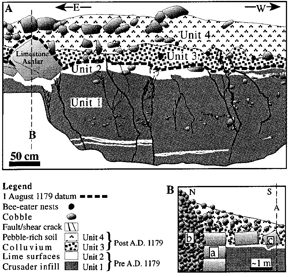
the foundation stone of the castle [of Vadum Jacob] was laid in October 1178 CE. The castle, only partially constructed at the time, was besieged and destroyed 11 months later, on 30 August 1179 CEproviding a terminus post quem of 1179 CE for its seismic destruction. Up to ~2.1 m of lateral slip was observed in the southern and northern defense walls along with up to 10 cm. of vertical slip. 0.5 m of the lateral slip was attributed to a later seismic event which damaged an Ottoman Mosque which was later built on the site. This left ~1.6 m of slip between the military destruction of the castle in 1179 CE and the seismic event that damaged the Ottoman mosque. In order to produce a terminus ante quem for initial seismic damage to Vadum Jacob, a trench was dug parallel to the southern face of the castle in which 4 units were identified. Units 1 and 2 were recorded as having been deposited on or prior to the castle's military destruction on 30 August 1179 CE. A fallen ashlar block on top of Unit 2 was presumed to have fallen immediately after the Muslim conquest as a historical source document (Abu-Shama) details partial dismantling of the castle soon after it was conquered. Colluvial Unit 3 was dated from 1179 CE to present and was presumed to have accumulated in the centuries after the Muslim conquest. Unit 4 is a modern bioturbated soil horizon. Faults within the trench were associated with seismic displacement of the Crusader wall and a later seismic event. Ellenblum et al (1998:305) described the faults as follows: The faults extend to two different stratigraphic levels: One group of faults displaces the alluvium of unit 1 and the limy level of unit 2, but extends only a few centimeters into post-1179 unit 3; the second group of faults breaks much higher into the colluvial wedge, up to the base of the modern soil horizon, and possibly to the surface. These observations suggest that at least two earthquakes produced the 2.1 m offset of the southern wall that is now observed. One event occurred soon after the outer ashlar wall was removed, i.e., very soon after 1179. The second post-1179 earthquake also produced rupture at Vadum Jacob, but well after removal of the wall and the accumulation of the colluvium, probably much closer to the present.Although a strict terminus ante quem was not established, the trench suggests that an earthquake struck soon after military destruction of the castle leaving the 1202 CE earthquake as the most likely candidate. |
| Baalbek | I can't find any archaeoseismic information on Baalbek for this time period. | ||
| Tell Ya'amun | possible | ≥8 |
Earthquake
Savage et al (2003:457-458) report the following: To the south of the previously excavated Byzantine church, we uncovered two rooms with walls surviving to a height of 2 m. Each room has a door opening onto the flat stone pavement that separates these rooms from the church. The mosaic floors are preserved along with the bases of archways for ceiling supports. Coins, architectural stratigraphy, and style of mosaic decoration all indicate contemporaneity between the sixth-century church and rooms. The rooms were modified during the Umayyad period when the mosaic floor was repaired with flat paving stones along the damaged edges and some walls were reconstructed with differently sized stones. Further modification and re-use occurred during the Ayyubid-Mamluk period when new walls were built directly on top of the mosaic floors. The mosaic floor of the east room is extensively dented by collapsed wall stones, which suggests that use ended with destruction caused by an earthquake. |
| al-Marqab Citadel | possible to probable | ≥7 Kázmér and Major (2010) estimated an Intensity of 8-9 but did not consider the possibility of a slope or ridge effect |
Earthquake I - 1187-1285 CE
Kázmér and Major (2010:194) report the following: Earthquake 1 produced the V-shaped extrusion on top of the donjon (60°–240°). This earthquake occurred after the donjon was completed and before the southern tower was built: there are no traces at all of this damage direction on the southern tower. Earthquake 1 occurred during the interval between 1187 and 1285, after Hospitallers took the castle and before Mamluk occupation. A candidate earthquake is that of 1202, this being the largest in the Middle East ever recorded (see Table 1).Kázmér and Major (2010:196) also stated Earthquake 1 consisted of vibration in SW-NE plane, damaging the donjon and room M3. It was a major event between 1187 and 1285, possibly the 1202 earthquake. |
| Chastel Blanc | possible to probable | ≥8 Kázmér and Major (2015:188) estimated a minimum intensity of IX (9). |
Kázmér and Major (2015) examined and dated
seismic effects on the donjon of Chastel Blanc (Safita) along with fallen architecture and rockfall evidence
from the nearby villages of Khirbat al-Qurshiyya and ‘Ayn-Qadıb. While they suggested that all three locations were affected by the 1202 CE earthquake, Chastel Blanc provided the
most reliable date. Their intensity estimate however came from all three sites. The dropdown panel below summarizes their chronological reasons for assigning archaeoseismic damage at
the donjon of Chastel Blanc (Safita) to the 1202 CE earthquake. See the full Chastel Blanc entry for
additional discussions on Khirbat al-Qurshiyya and ‘Ayn-Qadıb.
1202 CE Earthquake at the donjon of Chastel Blanc
Kázmér and Major (2015:187) assigned
Footnotes
1 Relevant excerpt from the letter of Phillipe de Plessis English |
| Amman Citadel | possible | needs investigation | |
| Location (with hotlink) | Status | Intensity | Notes |
| Location (with hotlink) | Status | Intensity | Notes |
|---|---|---|---|
| Byblos | possible | Morhange et al (2006:91) noted that
A review of the vertical movements having affected Lebanon during the late Holocene shows that tectonic uplift of the coastal areas occurred around 3000 yr BP, in the 6th century AD, and possibly in the 10th to 11th centuries AD (Pirazzoli 2005, Morhange et al., submitted). |
|
| Location (with hotlink) | Status | Intensity | Notes |
| Location (with hotlink) | Status | Intensity | Notes | ||||||||||||||||||||||||||||
|---|---|---|---|---|---|---|---|---|---|---|---|---|---|---|---|---|---|---|---|---|---|---|---|---|---|---|---|---|---|---|---|
| Kazzab Trench | possible to probable | ≥ 7 | Daeron et al (2007) dated Event S1 to between 926 and 1381 CE (2σ) and assigned it to the 1202 CE earthquake. Daëron et al (2005:529-530) presented surface faulting evidence that suggested younger less weathered fault scarplets on the Rachaıya-Serghaya faults and fresh mole-tracks on the Rachaıya fault were associated with one of the 1759 CE fault breaks while older more weathered faults scarplets on the Yammouneh fault were associated with one of the the 1202 CE earthquakes. | ||||||||||||||||||||||||||||
| Jarmaq Trench | possible | ≥ 7 | Nemer and Meghraoui (2006) date Event Z to after 84-239 CE. They suggested the Safed Earthquake of 1837 CE as the most likely candidate. | ||||||||||||||||||||||||||||
| al-Harif Aqueduct | possible | ≥ 7 | Sbeinati et al (2010) dated Event Z to between 1010 and 1210 CE (2σ) and suggested that it was probably caused by the 1170 CE earthquake. | ||||||||||||||||||||||||||||
| Qiryat-Shemona Rockfalls | possible | Kanari et al (2019) assigned the 1033 CE earthquake to sample QS-4 although Kanari (2008) assigned the same sample to the 1202 CE earthquake. Either are possible. | |||||||||||||||||||||||||||||
| Bet Zayda | possible to probable | ≥ 7 | Marco et al (2005) dated Event E.H. 1 to between 1020 to 1280 CE (ages were unmodeled) and assigned this event to the 1202 CE earthquake. They observed 2.2 m of offset which results in a 7.1-7.3 estimate of Moment Magnitude when using a relationship from Wells and Coppersmith (1994). | ||||||||||||||||||||||||||||
| Jordan Valley - Tell Saidiyeh and Ghor Kabed Trenches | possible | ≥ 7 | Ferry et al (2011) detected 12 surface rupturing seismic events in 4 trenches (T1-T4) in Tell Saidiyeh and Ghor Kabed; 10 of which were prehistoric. The tightest chronology came from the Ghor Kabed trenches (T1 and T2) where Events Y and Z were constrained to between 560 and 1800 CE. | ||||||||||||||||||||||||||||
| Dead Sea - Seismite Types | n/a | n/a | n/a | ||||||||||||||||||||||||||||
| Dead Sea - En Feshka | possible | 8.1 - 8.9 (12 cm.) 8.0 - 8.8 (28 cm.) 8.1 - 8.9 (40 cm.) |
Kagan et. al. (2011)
identified several seismites from around this time.
|
||||||||||||||||||||||||||||
| Dead Sea - En Gedi | possible | ? |
|
||||||||||||||||||||||||||||
| Dead Sea - Nahal Ze 'elim | possible | 8.2 -9.0 | At site ZA-1, Ken-Tor et al (2001a) assigned a a date of 1212 CE to a ~10 cm. thick Type 4 seismite which they labeled as Event E and was dated between 1220 and 1390 CE (± 2σ). In Table 4 of Kagan et. al. (2011), a 10.5 cm. thick seismite at ZA-1 was associated with the 1212 CE earthquake. At site ZA-2, Kagan et. al. (2011) did not find any seismites whose time window encompassed 1202 CE. | ||||||||||||||||||||||||||||
| Araba - Introduction | n/a | n/a | n/a | ||||||||||||||||||||||||||||
| Araba - Qasr Tilah | unlikley to possible | ≥ 7 | Haynes et al. (2006) dated Events II and III to between the 7th and 12th centuries CE. | ||||||||||||||||||||||||||||
| Araba - Taybeh Trench | unlikely | LeFevre et al. (2018) did not assign any seismic events to an earthquake in 1202 CE. | |||||||||||||||||||||||||||||
| Araba - Qatar Trench | possible | ≥ 7 | Klinger et. al. (2015) identified one seismic event which fits but was assigned to the 1212 CE earthquake..
|
||||||||||||||||||||||||||||
| Araba - Taba Sabhka Trench | possible | ≥ 7 | Allison (2013) assigned a 1068 CE date to a seismic event which they dated to between 1045 and 1661 CE and Allison (2013) assigned a 1212 CE date to a seismic event which they dated to between the mid 11th century CE and the 16-17th centuries CE. | ||||||||||||||||||||||||||||
| Araba - Shehoret, Roded, and Avrona Alluvial Fan Trenches | possible | ≥ 7 | Events 7, 8, and 9 in Trench T-18 have a wide spread of ages however, taken together, the evidence suggests the 1212 CE, 1068 CE, and one earlier earthquake, perhaps between ~500 CE and 1000 CE, struck the area. Zilberman et al (2005) also discovered an early Islamic ranch in the western part of Avrona playa. The ranch was dated to the 11th century CE and was abandoned during the same century - an abandonment which Zilberman et al (2005) attributed to the effects of the 1068 CE earthquake. They measured 1 m of displacement of a Qanat (a covered water canal) on the ranch which they also attributed to the 1068 CE earthquake although it is possible that the displacement was caused by an earthquake which struck the area in 1212 CE. | ||||||||||||||||||||||||||||
| Araba - Elat Sabhka Trenches | possible | Kanari et al (2020) suggested that a dewatering structure (aka a liquefaction fluid escape structure) found in Trench T1 and dated to before 1269-1389 CE was caused by the 1068 CE Quake(s) or the 1212 CE Quake. | |||||||||||||||||||||||||||||
| Araba - Trenches in Aqaba | possible | ≥ 7 |
Niemi (2011:153) noted that the most recent scarp-forming event fault [in Trench AQ-1] occurred after A.D. 1045-1278 based on a corrected, calibrated radiocarbon age from charcoal collected from a buried campfire at the base of the scarp in Trench T-1. This likely represents fault motion in one of the historical earthquakes affecting southern Jordan (e.g. 1068, 1212, 1458, or 1588). |
||||||||||||||||||||||||||||
| Location (with hotlink) | Status | Intensity | Notes |
Daeron et al (2007)
dated Event S1 to between 926 and 1381 CE (2σ) and assigned it to the 1202 CE earthquake.
Daëron et al (2005:529-530) presented surface faulting evidence that suggested younger
less weathered fault scarplets on the Rachaıya-Serghaya faults and fresh mole-tracks on the Rachaıya fault were associated with one of the 1759 CE fault
breaks while older more weathered faults scarplets on the Yammouneh fault were associated with one of the the 1202 CE earthquakes.
Nemer and Meghraoui (2006) date Event Z to after 84-239 CE. They suggested the
Safed Earthquake of 1837 CE as the most likely candidate.
Sbeinati et al (2010)
dated Event Z to between 1010 and 1210 CE (2σ) and suggested that it was probably caused by the 1170 CE earthquake.
Kanari et al (2019) assigned the 1033 CE earthquake to sample QS-4
although Kanari (2008) assigned the same sample to the 1202 CE earthquake.
Either are possible.
Marco et al (2005) dated Event E.H. 1 to between 1020 to 1280 CE (ages were unmodeled)
and assigned this event to the 1202 CE earthquake. They observed 2.2 m of offset which
results in a 7.1-7.3 estimate of Moment Magnitude when using a relationship from
Wells and Coppersmith (1994).
Ferry et al (2011) detected 12 surface rupturing seismic events in 4 trenches (T1-T4) in Tell Saidiyeh and Ghor Kabed; 10 of which were prehistoric. The tightest chronology came from the Ghor Kabed trenches
(T1 and T2) where Events Y and Z were constrained to between 560 and 1800 CE.
Note: Although
Ferry et al (2011) combined archaeoseismic interpretations, their paleoseismic evidence, and entries from earthquake catalogs to produce earthquake dates and some overly
optimistic probabilities, only the paleoseismic data is presented here.
Ferry et al (2011)'s archaeoseismic data was researched and is treated separately.
Kagan et. al. (2011) identified several seismites from around this time.
| Depth (cm.) | Thickness (cm.) | Seismite Type | Modeled Age (± 1σ) | Modeled Age (± 2σ) | Quake Assignment (Kagan) | Quake Assignment (Williams) |
|---|---|---|---|---|---|---|
| 12 | 7 | 4 | 1277 CE ± 17 | 1303 CE ± 64 | 1293 CE Quake | 1293 CE Quake |
| 28 | 2 | 4 | 1220 CE ± 21 | 1222 CE ± 46 | 1202 CE Quake and 1212 CE Quake | not assigned |
| 40 | 6 | 4 | 1170 CE ± 20 | 1168 CE ± 43 | 1170 CE Quake | not assigned |
Figure 10
At site ZA-1, Ken-Tor et al (2001a)
assigned a a date of 1212 CE to a ~10 cm. thick Type 4 seismite
which they labeled as Event E and was dated between 1220 and 1390 CE (± 2σ). In Table 4 of Kagan et. al. (2011), a 10.5 cm. thick
seismite at ZA-1 was associated with the 1212 CE earthquake.
At site ZA-2, Kagan et. al. (2011)
did not find any seismites whose time window encompassed 1202 CE.
Haynes et al. (2006) dated Events II and III to between the 7th and 12th centuries CE.
LeFevre et al. (2018) did not assign any seismic events to an earthquake in 1202 CE.
Klinger et. al. (2015) identified one seismic event which fits but was assigned to the 1212 CE earthquake.
| Event | Mean Date | Age Range | Quake Assignment (Klinger) | Quake Assignment (Williams) |
|---|---|---|---|---|
| E2 | 1212 CE ± 57 | 1155-1269 CE | 1212 CE Quake | not assigned |
Allison (2013)
assigned a 1068 CE date to a seismic event which they dated to between 1045 and 1661 CE and
Allison (2013)
assigned a 1212 CE date to a seismic event which they dated to between the mid 11th century CE and the 16-17th centuries CE.
Events 7, 8, and 9 in Trench T-18 have a wide spread of ages however, taken together, the evidence suggests the 1212 CE, 1068 CE, and
one earlier earthquake, perhaps between ~500 CE and 1000 CE, struck the area.
Zilberman et al (2005) also discovered an early Islamic ranch in the western part of Avrona playa. The ranch was dated to the 11th century CE and
was abandoned during the same century - an abandonment which Zilberman et al (2005) attributed to the effects of the 1068 CE earthquake.
They measured 1 m of displacement of a Qanat (a covered water canal) on the ranch which they also attributed to the 1068 CE earthquake although
it is possible that the displacement was caused by an earthquake which struck the area in 1212 CE.
Kanari et al (2020) suggested that a dewatering structure
(aka a liquefaction fluid escape structure) found in Trench T1 and dated to before 1269-1389 CE was caused by the
1068 CE Quake(s) or the
1212 CE Quake.
Niemi (2011:153) noted that the most recent scarp-forming event fault [in Trench AQ-1]
occurred after A.D. 1045-1278 based on a corrected,
calibrated radiocarbon age from charcoal collected
from a buried campfire at the base of the scarp in
Trench T-1. This likely represents fault motion in one
of the historical earthquakes affecting southern
Jordan (e.g. 1068, 1212, 1458, or 1588).

Fig. 16. Map of intensity distribution for May 20, 1202 earthquake
(Ambraseys and Melville, 1988). Shaded zone is the most affected
region. (from
Sbeinati et al, 2005)
AD 1202 May 20 Baalbek
A large earthquake occurred in the Middle East around
daybreak on 20 May 1202. It was felt across an area of
radius 500 km: from the Nile Delta in the south to Lesser
Armenia in the north and from Cyprus in the west to the
eastern parts of Syria.
It caused widespread damage in Syria. In Tyre,
everything, with the exception of three towers and some
outlying fortifications, was destroyed. A third of Acre
was probably destroyed, with considerable damage to the
royal palace and the walls, although the Knights Templar
complex in the southwest of the city was spared. At least
some repairs took place in both cities.
Inland, in Samaria (Shamrin) and Hauran, dam-
age was equally severe. It was reported that Safa was
partially destroyed, resulting in the deaths of all but the
son of the garrison commander. Also Hunin (Chastel
Neuf), Baniyas (Paneas) and Tibnin (Toron) were badly
affected. The walls at Bait Jann collapsed. A landslide
reportedly razed a village near Busra to the ground and
Nablus was totally flattened, except for a few walls, and
may have sustained further damage in an aftershock.
Most of the towns of the Hauran were so badly damaged
as to be rendered unidentifiable.
Jerusalem suffered relatively little, but further
north Damascus was strongly shaken. Many houses
apparently collapsed and major buildings near the citadel
were damaged. The Ummayad mosque lost its eastern
minaret and 16 crenellations on its north wall. One man
died when the Jirun (eastern) gate fell and the lead
dome split in two and one of the other minarets fissured.
The adjacent Kallasa mosque was ruined, killing
two people, and the nearby Nur ed Din Hospital was
completely flattened. People fled to the safety of open
spaces.
Further north, houses collapsed in Jubail
(Gibelet), the battlements of the walls of Beirut had
to be repaired and Batun was damaged, but this damage
may have been due, at least partially, to military attacks.
Rock falls on Mt Lebanon killed 200 people and nearby
Baalbek was almost totally ruined.
Damage to Tripoli was probably substantial, since
it is said that there was loss of life. The castles of Arches
(`Arqa) and Arsum (`Arima?) were almost destroyed,
and Chastel Blanc (Safitha) was badly weakened, while
the castles of Margat (Marqab), Krak (Hisn al-Akrad)
and Barin suffered some damage but remained secure.
Tarsus (Tortosa) largely escaped damage, however.
At Hims (Homs, Emessa) the earthquake caused
a castle watchtower to collapse. In Hamah there were
two shocks, the first lasting for a long time, then a second,
stronger shock, which destroyed the castle and many
other buildings.
The earthquake was felt in Aleppo and other
regional capitals, and less strongly in Antioch. It was perceptible
at a few places further away, such as Mosul and
in Mesopotamia, at Akhlat and from Qus on the Nile.
In Egypt, the shock was felt in Alexandria and in Cairo
woke sleepers and shook buildings, threatening the collapse
of tall structures.
In Cyprus the earthquake was felt, causing no
damage, but it was felt strongly on the east coast of the
island, where a seismic sea wave flooded the eastern coast
of Cyprus and the coast of Syria.
The death toll is uncertain bacause the earthquake
coincided with famine and plague, but it must have
been high, since it struck at daybreak when most people
were still in bed.
Aftershocks lasting at least four days were
reported in Hamah, Damascus and Cairo. For an attempt
to locate a probable coseismic surface fault break the
basis of exclusively on geomorphology, see Ellenblum
et al. (1998) and Daeron et al. (2005)
This earthquake has been examined by
Ambraseys and Melville (1988). However, new data
have been found, and the intensity has been re-evaluated
using a modified version of the MSK intensity scale,
which takes into account the high vulnerability of the
building stock in the region, necessitating a review of the
original conclusions. Also because of the importance of
the event and for the sake of completeness, a summary
and full translations of the most important sources are
given here.
This was a major earthquake in the upper Jordan
and Litani Valleys, responsible for tens of thousands of
casualties in the Eastern Mediterranean region. Owing to
the Crusader presence in the Levant, information on the
effects of the earthquake is available from both Chritian
and Muslim authors. Both sets of data naturally
refer most particularly to the territory belonging to their
respective sides, but they complement each other to a
large degree.
It is clear that most of the chronological confusion
surrounding the event has been caused by the uncritical
use of Muslim chronicles. It is also remarkable that hardly
any use has been made of western sources, which are far
more accessible to most European authors and unambiguously
resolve the dating of the earthquake. These
works, though largely ignored by earthquake cataloguers,
are of course well known to the historians of the Crusades
(e.g. Rehricht 1898).
The political context of the earthquake is briefly
outlined in Mayer (1972; 1989; see also [1, 2]) and more
fully in Cahen (1940), Runciman (1951; 1952; 1954; 1965)
and Setton (1969), where detailed reference is made to
the narrative sources available. The Crusader states had
been greatly reduced by Saladin's campaign of 1187 and
only partially reconstituted by the Third Crusade, most of
their defenses being in a vulnerable state of repair.
Regarding the non-Muslim accounts, it is unfortunate
that the main political and military developments at
this time were taking place outside the Levant, in preparation
for the ill-fated Fourth Crusade. The focus is not,
therefore, so clearly on events in the east, where the Crusader
states were on the defensive and greatly reduced
in terms of their sphere of operations. Most of the few
places retained by the Christians are mentioned in European
accounts, all in the truncated kingdom of Jerusalem
and the county of Tripoli, on or near the coastal strip.
No details of wider effects in the Syrian hinterland
are given in Christian sources. Similarly, no details of
the shock further north, in the principality of Antioch, are
provided, beyond the indications that it was not severe
there.
The two letters from the Hospitaller and Templar
Grand Masters published in Mayer (1972) contain
the fullest occidental accounts and refer particularly to
the possessions of their respective Orders. Very few
additional details are found in other sources (among
them the references to Jubail in various texts of the
Annales de Terre Sainte).
As demonstrated by Mayer, the near contemporary
account of Robert of Auxerre (died
1212) has many points of similarity with Philip du
Plessis' description. Variations of date occur in the
Christian sources, but not concerning the year. William
of Nangis (died c. 1300) gives 30 May, three days before
Ascension (which was in fact on 23 May in 1202). Felix
Fabri (fl. 1480) has 30 March. The Barletta manuscript
(Kohler 1901, 401) appears to read 3 March. Most of
these sources are telegraphic, containing only general
information.
Arabic sources from the Muslim areas surrounding
the Christian states naturally offer a broader perspective
and provide the most information. Just as both the
contemporary European letters date the earthquake to
Monday 20 May 1202, so do a comparable pair of Arabic
letters from Hamah and Damascus. These were received
by `Abd al-Latif b. al-Labbad al-Baghdadi, who was in
Cairo at the time of the earthquake and wrote his account
in Ramadan 600/May 1204, two years after the event.
Both he and the letters he transcribes give the date as
early on the morning of Monday 26 Sha'aban 598 hijri
(Muslim calendar = 21 May 1202, which was a Tuesday)
or 25 Pashon (Coptic calendar = Monday 20 May). A discrepancy
of one day is common when converting from
the Muslim calendar. As noted above, the latter date is
confirmed by the contemporary European accounts. Abu
Shama, quoting the testimony of al-'Izz Muhammad b.
Taj al-Umana' (died a.H. 643/AD 1245), also had Monday
26 Sha'ban, 598 or 20 Ab (Syriac calendar = August
(sic.) 1202).
There can thus be no doubt that the correct Muslim
year is 598 a.H. which runs from 1 October 1201
to 19 September 1202. Unfortunately other later Arabic
texts contain variations on the date of the earthquake and
in some cases split its effects into accounts of separate
events in different years. The most influential of these
alternative texts is that of Ibn al-Athir of Mosul (died
1233), who has a general account of the earthquakes felt
throughout Mesopotamia, Egypt, Syria and elsewhere,
dated Sha'ban 597 a.H. which is a year early. It is not
clear whether he refers to the same event. His account
is followed almost verbatim in the Syriac Chronicle of
Bar Hebraeus (Abu 'l-Faraj, died 1286), and in greatly
abbreviated form by Abu 'l-Fida (died 1331), under 597
a.H. Another early source, Abu 1-Fada'il of Hamah (c.
1233) has a brief notice of the shock under 597 a.H.
It is of interest that he does not refer to the shock in
Hamah, but mentions that it destroyed most of the towns
belonging to the 'Franks'. Reconciling these accounts is
no problem; it is simply that an error of one year has
occurred.
A greater problem is introduced since Ibn al-
Athir has another, shorter but similar, account of the
(same) earthquake under the year 600 a.H. (10 September
1203 to 28 August 1204), without specifying the
month. He says that the shock destroyed the walls of Tyre
and also affected Sicily and Cyprus. This 'second' earthquake
is once more reported by Bar Hebraeus and Abu
'l-Fida. A similar account, with the addition of new information
that the shock was felt in Sabta (Ceuta), is given
by Ibn Wasil (died 1298). Since Ibn Wasil was a native
of Hamah, it is surprising that he does not have access to
independent local information. Neither does he have any
reference to the shock under 597 or 598 a.H.
It is not clear why Ibn al-Athir should duplicate
his account under the dates 597 and 600 a.H., but it is
perhaps sufficient to note that this sort of duplication is
not uncommon in both European and Islamic medieval
chronicles. Within this repetition, there must be some
echo of large aftershocks or a prolonged period of seismic
activity.
Two separate notices are also found in the chronicle
of Sibt b. al-Jauzi (died 1256), this time under 597
and 598 a.H. The first account, under Sha'ban 597 a.H.
echoes that of `Abd al-Latif, while mentioning a few additional
places. The date, however, is the one given by
Ibn al-Athir. Sibt b. al-Jauzi supports this date by saying
(480) that after these earthquakes in a.H. 597/AD 1201,
both 'Imad al-Din (the historian whose work he had earlier
quoted for an account of the famine in Egypt that
year) and the author's own grandfather (the historian Ibn
al-Jauzi) died. It is generally accepted that both men did
indeed die in this year and thus 'before the earthquake'.
This is awkward to explain, but the author is probably
trying to rationalise two conflicting pieces of chronological
data. He is not so much dating the deaths by reference
to the earthquake as accommodating the false date that
he has accepted for the earthquake within the sequence
of other events that year. Under the correct year, 598
a.H. he has a much briefer account, describing damage
to the castles at Hims and Hisn al-akrad. He says the
shock extended to Cyprus and destroyed what was left
of Nablus (i.e. after the first earthquake). This implies
two shocks. On the other hand, Sibt b. al-Jauzi's second
account is not unlike Ibn al-Athir's second account
(under 600 a.H.), and may again simply be an attempt to
accommodate the conflicting dates. It is significant that
Sibt b. al-Jauzi has no report of an earthquake under
600 a.H. Abu Shama, who quotes Sibt b. al-Jauzi's
accounts under 597 and 598 a.H. in turn, in both cases
cites the additional testimony of al'Izz b. Taj al-umana',
a descendant of Ibn `Asakir and continuator of the latter's
Biographical History of Damascus (Cahen, 1940).
It is clear that the first part of Sibt b. al-Jauzi's 597
a.H. account also follows al-'Izz. Under 598 a.H. al-'Izz
records the effect of the shock in northern Syria and in
Damascus, with some minor details in addition to those
provided by `Abd al-Latif.
A1-Suyuti summarises the dating confusion found
in his sources, by entering the earthquake under 597
a.H. (quoting al-Dhahabi, `Ibar and Sibt b. al-Jauzi), 598
a.H. (quoting Sibt b. al-Jauzi) and 600 a.H. (citing Ibn
al-Athir). Later sources add no details. It is worth noting
that the Aleppo author Ibn al-'Adim (died 1262) makes
no reference to the earthquake under any of the years
found elsewhere.
Despite the conspicuous duality of accounts in
almost all Muslim sources, probably reflecting protracted
aftershock activity, there remains no evidence of more
than one principal but multiple earthquake. Apart from
the silence of contemporary occidental and oriental
authors, `Abd al-Latif was in a position to record separate
earthquakes in both 597 and 600 a.H. had they
occurred. The amalgamation of these several accounts
therefore removes much of the mystery surrounding the
a.H. 598/AD 1202 event, and allows a coherent identification
of its effects and the area over which it was
felt. Many sources speak of strong effects and significant
damage along the Mediterranean littoral of Syria,
affecting both the 'Franks' and the 'Saracens' (Abu
'l-Fada'il, fol. 113a-b; Hethum Gor'igos, 480, Ibn al-
Furat, 240). Specifically, the two main Christian centres,
Acre and Tyre, were severely damaged, with loss of life.
Contemporary letters (Mayer 1972) speak of damage to
walls and towers in both cities, including the palace at
Acre. The house of the Templars in Acre (in the southwest
of the city, see Enlart 1928, 23) was, however, fortunately
spared. All but three towers and some outlying
fortifications were destroyed in Tyre, together with
churches and many houses. The English chronicler Ralph
of Coggeshall (died 1228) says that most of Tyre and
one third of Acre were overthrown (Cogg. 141-2). Muslim
sources largely confirm this, `Abd al-Latif stating that
the greatest part of Acre and one third of Tyre were
destroyed. Intensities in Tyre may be assessed as having
been higher than those in Acre, respectively about IX
and VIII. Funds were made available for both cities to be
reconstructed (L'Estoire de Eracles, 245; Sanuto ii, 203),
though no specific indication of the extent of these repairs
is available (Enlart 1928, 4, Deschamps 1939, 137).
Inland from the Christian territories, in Shamrin
(Samaria) and Hauran, damage was equally serious. It
was reported that Safad was partially ruined, with the loss
of all but the son of the garrison commander; also Hunin
(Chastel Neuf), Baniyas (Paneas) and Tibnin (Toron)
were badly affected. At Bait Jann (Bedegene), not even
the foundations of walls remained standing, everything
having been 'swallowed up'. Two possibilities present
themselves for the identification of Bait Jann out of the
three noted by de Sacy in `Abd al-Latif (446), both being
known to the Crusaders (see Dussaud 1927, 7, 391). The
first is 10 km west of Safad and the second on the road
between Damascus and Baniyas (see Ibn Jubayr (300),
who described it as situated in between the mountains).
The context in which Bait Jann is mentioned by `Abd al-
Latif allows either alternative to be acceptable, but the
second .is preferred here because the location was better
known as marking the boundary between Muslims and
Franks before the conquests of Saladin (cf. Deschamps
1939, 146). In Nablus there was total destruction except
for some walls in the 'Street of the Samaritans', while in
Hauran province most of the towns were so badly damaged
that they could not be readily identified (`Abd al-
Latif, 417, Sibt b. al-Jauzi, 478). It is said that one of the
villages around Busra was completely destroyed, perhaps
by landslides (Ibn al-Athir, xii, 112).
To the south of this area, Jerusalem suffered
lightly, according to the information available to `Abd al-
Latif (415, 417). His account indicates that further north,
however, Damascus was strongly shaken. A number of
houses are reported to have collapsed and besides the
destruction in town, major buildings near the citadel were
damaged. The Umayyad mosque lost its eastern minaret
and 16 ornamental battlements along its north wall. One
man was killed in the collapse of the Jirun (eastern) gate
of the mosque. The lead dome of the mosque was split
in two and one other minaret fissured (cf. Le Strange
1890, 241). The adjacent Kallasa mosque was ruined,
killing a North African and a Mamluk slave (Abu Shama,
29, quoting al-'Izz). This building had been founded in
1160 by Nur al-Din and restored by Saladin in 1189 after
its destruction by fire (Elisseeff 1967, 294). West of the
mosque, Nur ad Din's hospital was completely destroyed.
People fled for the safety of open spaces. The shock
in Damascus was of long duration and old men could
not recall ever .having felt such a severe tremor (`Abd
al-Latif, 416-417). Previous destructive earthquakes had
occurred in 1157 and 1170. Another slight shock was felt
early the following morning (Abu Shama, 29), and aftershocks
continued for at least four days (`Abd al-Latif,
417). Further north, houses are said to have collapsed
at Jubail (Gibelet), which had recently been recovered
by the German Crusade (1197), restoring the land link
between the Kingdom of Acre and the County of Tripoli
(Annales de Terre Sainte, 435, Chronique de Terre Sainte,
16). The walls of Beirut, also regained in 1197, are said
to have been repaired at about this time following earthquake
damage (variant readings in L'Estoire de Eracles
(244-245) incorrectly under 1200; likewise Ernoul, 338).
The fact that the Prince of Batrun, a Pisan, granted his
compatriots remission of taxation early in 1202 indicates
that this town too suffered damage (Muralt 1871, 264).
The extent of the destruction is not easy to assess in these
places. The walls of Jubail were dismantled by Saladin
in 1190 and were probably not rebuilt after the Christian
takeover. Wilbrand of Oldenburg, who visited Jubail
in 1211, found only a strong citadel, and a similar situation
in Beirut and Batrun (166-167; cf. Rey 1871, 121).
There is therefore the danger that the extensive military
operations in the period before and during the Third Crusade
are misreported as earthquake damage, and even if
this is not the case, some of these castles may have been
rendered more vulnerable by acts of warfare. Inland rock
falls from Mt Lebanon, however, overwhelmed about 200
people from Baalbek who were gathering rhubarb. Baalbek
itself was destroyed despite its strength and solidity
(`Abd al-Latif, 416).
In the County of Tripoli, the Christian sources disagree
slightly on the degree of damage to Tripoli itself,
though both main accounts refer to heavy loss of life
(Mayer 1972). Ibn al-Athir (xii, 112) also refers to the
heavy damage there, suggesting intensities not less than
VIII. Other strongholds were severely shaken. The castle
of 'Arco (Arches) was ruined and deserted villages
in the area were taken by Philip du Plessis to indicate
heavy loss of life, but perhaps this simply implied the
flight of the inhabitants, since famine and sickness were
also rife. It may be noted that Rey (1871, 92) cites `Abd
al-Latif and Robert of Auxerre concerning an earthquake
in Sha'ban 597 (sic.)120 May 1202 that destroyed Jebel
`Akkar and Chastel Blanc, falsely equating `Archas'
with `Akkar, which the occidentals called Gibelcar. The
destruction of `Arqa is also mentioned by Arab writers
(`Abd al-Latif, 417, Abu Shama, 29). Philip du Plessis
records the complete destruction of the castle at `Arsum',
which is not satisfactorily identified but perhaps refers to
`Arima. Mayer (1972, 304) is reluctant to identify Arsum
but points to the possibility of Arsuf, near Caesarea. Support
for this is found in the account of the pilgrimage
of Wilbrand of Oldenburg, who in 1212 found the small
ruined town of `Arsim' (Arsuf) on his way to Ramla
(184). As Mayer mentions, however, the letter seems to
refer rather to a place in Tripoli, and `Arima is suggested
on the grounds (1) that it probably belonged to the Templars
and (2) it was one of the few strongholds retained
by the Christians in the truce that ended the Third Crusade
(Setton 1969, i. 664). It is situated a few miles south-southwest
of Chastel Blanc. Philip further reported that
the greater part of the walls of the Templar stronghold
Chastel Blanc (Safitha) had fallen and the keep had been
weakened to such an extent that it would have been better
had it collapsed completely. `Abd al-Latif (417) also
mentions the destruction of the castle. The castle keep
was probably rebuilt using existing materials (Deschamps
1977, 257-258). Tortosa (Tartus), however, its Templar
citadel and notably the Cathedral of Notre Dame seem
largely to have been spared (Berchem and Fatio 1914,
323; Enlart 1928, 397).
The Grand Master of the Hospitallers (Geoffrey
of Donjon) wrote that their strongholds at Margat (Marqab)
and Krak were badly damaged but could probably
still hold their own in the event of attack. Damage to
Krak (Hisn al-akrad) is also mentioned in the account of
Sibt b. al-Jauzi (510). In the same vicinity, but in Muslim,
hands, the castle of Barin (Montferrand), despite its compactness
and fineness, was also damaged (`Abd al-Latif,
416).
There is little additional evidence to help assess
the intensities indicated by these reports. Authors
of studies of military architecture (e.g. Rey 1871,
Deschamps 1934; 1977) on the whole use documentary
evidence of earthquakes to support the chronology and
identification of building phases at the castles, rather than
documentary or archaeological evidence of rebuilding to
indicate the extent of earthquake damage. Indeed, it is
interesting that Deschamps, unaware of the reports of
earthquake damage at Marqab in 1202, makes no reference
to this specific period as being one of substantial
building at the castle (Deschamps 1977, 282-284),
whereas in the case of Krak, damage done by the earthquake
is thought to have been responsible for some of
the reconstruction work analysed (Deschamps 1934, 281).
Even so, the fact that the knights of Krak were frequently
on the offensive in the next few years after 1203, and
were joined by the knights from Marqab, is thought to
indicate that both castles Were 'already in a perfect state
of defence'. These raids may rather suggest that attack
was the best form of defence. Nevertheless, the circumstantial
testimony by Geoffrey can be taken at face value
and is supported by the fact that Marqab successfully
resisted a counter-attack by al-Malik al-Zahir, amir of
Aleppo, in a.H. 601/AD 1204-1205 (Ibn Wasil, iii. 165).
Both Marqab and Krak were visited in 1211 by Wilbrand
of Oldenburg and seemed to his probably unprofessional
gaze to be very strong, the latter housing 2000 defendants
(169-170). Few details are available about Barin, which
was finally dismantled in 1238-39 (Deschamps 1977, 322).
It seems unlikely that intensities exceeding VII coupled
with a long duration of shaking were experienced at any
of these strongholds.
In neighbouring Muslim territory, the shock
was experienced at similar intensities in Hims (Hons,
Emessa), where a watchtower of the castle was thrown
down (Sibt b. al-Jauzi, 510), and Hamah, where the earthquake
was experienced as two shocks, the first lasting 'an
hour' and the second shorter but stronger. Despite its
strength, the castle was destroyed, together with houses
and other buildings. Two further shocks followed in the
afternoon (`Abd al-Latif, 416). Considerable damage to
houses in both towns is implied by Ibn al-Athir (xii,
112).
Further north, the earthquake is said to have been
felt in Aleppo and other regional capitals (Sibt b. al-Jauzi,
478), and also in Antioch, though less strongly (Geoffrey
of Donjon). It was also reported as being perceptible
in Mosul and throughout the districts of Mesapotamia,
as far as Iraq. Azerbaijan, Armenia, parts of Anatolia
and the town of Akhlat are said to have experienced the
earthquake (Ibn al-Athir, xii, 112; Sibt b. al-Jauzi, 478).
In the south, the shock was felt throughout Egypt
from Qus to Alexandria. Sibt b. al-Jauzi (478, probably
quoting al-'Izz) says that the shock came from al-Sa'id
and extended into Syria, al-Sa'id being the region south
of Fustat (Old Cairo) down to Aswan (Yaqut, iii, 392).
In Cairo, the shock was of long duration and aroused
sleepers, who jumped from their beds in fear. Three violent
shocks were reported, shaking buildings, doors and
roofs. Only tall or vulnerable buildings were particularly
affected, and those on high ground, seemed on the verge
of collapse (`Abd al-Latif, 414-415). The details provided
indicate that Egypt experienced shaking of long duration,
as is typical of other large earthquakes occurring at great
epicentral distances away (Ambraseys 1991; 2001).
Another earthquake, probably of considerable
magnitude, was felt at about midday the same morning,
probably the one reported from Hamah at midday on
Tuesday 27 Sha'ban (21 May). It should have been a large
shock but its effects cannot be separated from those of the
main shock.
The shocks were felt in Cyprus, which had been
under Frankish rule since 1191, the earthquake causing
some damage to churches, belfries and other buildings
(Annales 5689, fol. 108b; `Abd al-Latif, 415; Ibn al-Athir,
xii, 130). Damage to buildings is not, however, very well
attested and it is noteworthy that most of the `cypriot
chronicles' refer only to damage on the mainland. In the
words of the Arabic authors, the sea between Cyprus and
the coast 'parted and mountainous waves were piled up,
throwing ships up onto the land'. It is said that the eastern
parts of the island and of the Syrian coast were flooded
and numbers of fish were left stranded (`Abd al-Latif,
415; Ibn Mankali in Taher 1979). The significance of this
seismic sea wave is discussed below.
The loss of life caused by this earthquake and its
aftershocks is difficult to estimate. A figure frequently
quoted in Arab sources is 1 100 000 dead (e.g. al-Dhahabi,
iv, 296, al-Suyuti, 47) for the year 597-598 a.H. (AD
1201-2). This specifically includes those dying of famine
and the epidemic consequent on the failure of the Nile
floods, graphically described by `Abd al-Latif, who notes
111 000 (sic.) deaths in Cairo alone between 596 and 598
a.H. (412). More realistically, the figure of 30 000 casualties
is given, primarily, it would seem, in the Nablus area
(Sibt b. al-Jauzi, 478). No reliance can be placed on such
figures, but the fact that the main shock occurred at dawn,
when most people were in bed, without noticeable foreshocks,
probably contributed to a high death toll.
Aftershocks were reported from Hamah, Damascus
and Cairo, for at least four days (`Abd al-Latif, 417;
Abu Shama, 29), one of which, apparently felt in Cairo
and Hamah, must have been a large event. There remains
the possibility that the aftershock sequence was terminated
with a destructive shock that totally destroyed what
was left of Nablus, but it seems preferable to consider
both reports by Sibt b. al-Jauzi as referring to the same
shock. Whatever the exact sequence of events, the cumulative
effects of the earthquake were clearly very serious.
Most of the sites affected in the epicentral region
must have needed total reconstruction or major repairs,
although in most cases the evidence is circumstantial, not
specific.
More information can be found in Abu Shama
(Dhayl 18v, 29r), Alexandre (1990, 170), Rohricht (1893,
1114); Alb. Mil., Amadi, Fabri, Ibn al-Furat (k. 132),
Het'um (Chron.), Ibn al-Dawadari, Katib Celebi, Mem.
Edm. Abb.; Nuwairi (118v) and Sal. Ad. 23 (see below).
In contrast to authors of earlier studies, who
assign to the event an excessive radius of perceptibility of
over 1000 km, we find that in fact the area within which
the earthquake was generally felt was confined to an area
of radius only about 500 km.
To the south and close to the epicentral area
Jerusalem suffered lightly. There is no evidence that the
shock was felt west of Cyprus, that is on Crete, the
Aegean Islands, or mainland Greece, and this during
a period for which occidental and local sources from
coastal areas are not lacking. Also the shaking reported
in and around Constantinople on or after 1 March
1202 obviously was not from the earthquake of 20 May
(Nicetas, 701 (19).
Moreover, no evidence for an earthquake has
been recovered in the western Mediterranean area. The
earthquake is said to have been felt as far away as Sicily
(Ibn al-Athir, xii, 130) and Ceuta (Ibn Wasil, iii, 161),
but this lacks confirmation in the annals of the Muslim
west, which was dominated by the Almohads during this
period.
The occurrence of a seismic sea wave between
Cyprus and the Syrian coast, 50-100 km from the epicentral
region, is difficult to understand. It may be explained
by invoking the generation of a large-scale subaqueous
slide from the continental margin of Syria by the earthquake.
North of Acre the continental shelf narrows to a
few kilometres and off the coast of Lebanon the continental
slope steepens from near Acre northwards to an
average of 10°. Under these circumstances, the principal
cause of a seismic sea wave could be submarine sliding
and slumping. The whole of that coast is certainly prone
to slumping because of evaporites in the sedimentary
section.
Its epicentral region, within which intensities were
high, forms a narrow inland strip about 200 km long and
40 km wide extending from Nablus in the south to 'Arca
in the north. The number of sites at which intensities can
be assessed is obviously insufficient to allow the construction
of a proper isoseismal map (but cf. Sieberg 1932b).
However, it would appear that the maximum effects of
the earthquake were experienced inland away from the
coast, in the upper Jordan and Litani valleys, as well as
the upper reaches of the Orontes river, in the vicinity
of Baalbek. Several thousand people perhaps perished in
this area. Without further details, it is difficult to indicate
more precisely the exact location of the epicentral region.
The vague details of severe damage in the Hauran district
may suggest that the rupture zone was wide. Since most of
the aftershocks were reported from the north (Hamah), it
may be conjectured that the event nucleated in the south,
near Nablus, and that it was completed by a second rupture
that originated in the Tyre-Baalbek segment of the
meizoseismal area. Apart from the statement that largescale
landslides occurred on Mt Lebanon, there is no
historical indication that this event was associated with
faulting. However, field evidence suggests surface faulting
that is perhaps associated with this and the earthquake
of 1759 (Daeron et al. 2005).
The 20 May 1202 earthquake(s) may, however, be
compared with the earthquake sequence between June
1759 and January 1760, which had almost exactly the
same epicentral region. One important aspect of the 1759
earthquake, which is much better documented, is that
it was associated with a 95-km-long fault break in the
Bekaa, on the west side of the valley, many metres wide
in places (Archives Nationales, 1759). It is not possible
to assess the tectonic effects of the 1202 earthquake,
which seems to have been multiple and comparable to
the shock of 1759 in terms of location and the extent of
faulting.
To the most excellent Lord, and most outstanding benefactor, Sancho, by grace of God the glorious king of Navarre: from Brother Geoffrey, humble master of the house of the Jerusalem Hospital, with all his brethren, greetings and the fellowship of devoted prayer. As Your Majesty's ears are no strangers to the sorrows and miseries of the kingdom of the Promised Land, we are reluctantly obliged to relate to Your Highness the lamentable afflictions, which have recently occurred in that place.
While everything was silent, and night was running her course, on the 20th day of May, which is named after the moon [i.e. Monday], at the hour when sleep caresses tired eyes, a little before first light, the wrath of God engulfed us, and there was a great earthquake. Of the cities and fortresses of the East, as well pagan as Christian, some were overthrown, some destroyed, and others, on account of the damage caused by the shocks, were threatened with ruin. The city of Acre, a most convenient port, suffered an unspeakably dreadful and death-dealing blow: some of the towers, the ornate royal palace and walls were ruined, and there was death among rich and poor. O lamentable occurrence! Tyre, a city of strength and a refuge of Christians, which always freed the oppressed from the hands of evil-doers, suffered so great an overthrow of its walls, towers, churches and houses that no man living now could expect to see it restored in his lifetime. What should we write about the death of the men of that city, when death took them without number in the ruins of their homes? This sorrow, this death, lamentable before [all] other things, and this unfortunate event adds shudders [of terror] to our fear. The most splendid city of Tripolis, although suffering considerable harm to its walls and houses, and death to its citizens, underwent less of an upheaval [than Tyre]. The towers, walls, houses and fortifications of Arches [`Arqa] were razed; their people were killed, and the localities are deserted: one would think that they had never been inhabited. Our fortresses of Krak [Hisn al-'Akrad] and Margat [Marqab] suffered considerable damage, but in spite of the heavy shaking they received from the divine wrath, could still hold out against enemy attacks. Antioch and parts of Armenia were shaken by this earthquake, but did not suffer damage to the same lamentable extent.
The pagan cities and peoples bewailed the fact that they had received incurable wounds from this unforeseen fate. Especially when our hearts were afflicted with so many sorrows, food was extremely expensive, and a plague fatal to animals added further misery to all the remaining Christians.
We also felt obliged to bring to Your Gracious Lordship's ears that while the harvest was green, showing that an abundance of crops was coming to us once more, a cloud overshadowed the sprouting ears [of wheat] on the Feast of St Gregory, so that when the crops were harvested they were found to be very blighted: we have a surfeit of paupers and our land is afflicted with an influx of beggars. Therefore, Lord of Virtues, most excellent King, may the Land of the Lord's Nativity, sunk in sorrow and misery, and almost annihilated by calamities, be revived by your generosity, and by your counsel be comforted in her desolation.' (Geoffrey of Donjon, in Mayer 1972, 306-308).
To his venerable father and beloved friend, by the grace of God, the abbot general of the Order of Cistercians: Philip de Plessis, humble master of the Knights Templar, sends greeting trusting more in the Lord than in man, Amen. Believing in you heartfelt concern for the good and well-being of the Eastern Lands, it behoves me to relate to you the terrible misfortunes, unheard-of calamities, unspeakable plagues and punishment as of God, which has come upon us in punishment for our sins. [First two disasters: Christian population of County of Tripoli threatened, farmers take refuge in castles and cities; "fog" comes down and ruins three quarters of crops.]
The third [calamity], which was more sorrowful and terrible than the others: on the 20th day of May, at the crack of dawn, a terrible sound was heard from heaven, and there was a dreadful roar from the earth and an earthquake, such as has never been from the beginning of the world, such that most of the walls and houses of Acre were razed to the ground and a countless multitude of the inhabitants were killed. God, in his mercy to us, preserved our houses [i.e. those of the Knights Templar] intact. As for the city of Tyre, all the towers except three and the walls, except for the outer barbican, and all the houses with their people, save a few, fell to the ground. A very large part of the city of Tripolis collapsed, killing a great number of people. The castle of Arches ['Arqa], with all its houses, walls and towers was fattened, and the castle of Arsum [Arima?] was razed to the ground. Most of the walls of Chastel Blanc [Safitha], and the larger tower [of the latter], which we believed was surpassed by none in the strength and compactness of its construction, was weakened by cracks and shaking: it would have been better for us if it had collapsed totally, than remained standing in that condition. The city of Tortosa [Tarsus], however, and its fortress with its towers and walls and people and all was preserved by divine mercy. [Fourth calamity: plague] [Valedictory]' (Philippe de Plessis, in Mayer 1972,308-310)..
(1202) In that year there was a great earthquake in Syria, in which cities and towns were engulfed.' (Sal. Ad. 23).
(a.1202) There was a great earthquake which ruined Acre, Tyre, Giblet, Arzer and a great part of Tripolis, together with many other lands of the Christians and infidels.' (Amadi, 91f.).
In 1202 there was a great earthquake which struck Acre, Tyre, Gibelet and Arches, and several other cities.' (Annales 6447).
The region of Outremer was afflicted by a great disaster: on 20th May, around daybreak, a terrible sound was heard in the sky and an awful rumble from the earth, and there were earthquakes so violent that the most part of the city of Acre, with its ramparts, houses and even the royal palace, was razed to the ground, and countless persons were wiped out. Similarly the city of Tyre, the most [strongly] fortified in those parts, was almost completely overturned, while all of its towers bar three collapsed, and the ramparts, as high as they were solid, were either badly damaged or almost thrown to the ground, except for some forewalls which they call barbicans; all the houses and the buildings, with a few exceptions, were shaken. Likewise in the region of Tripolis the castle of Arqa, a great fortress, was razed to the ground with its towers, ramparts, houses and people. A great part of the city of Tripolis fell too, and many people were killed. Similarly most of the ramparts and towers of Chastel-Blanc [Safitha] were thrown to the ground. There were few coastal cities which did not suffer some damage: the city of Antaradus, which is also called Tortosa, escaped this disaster unharmed and intact.' (Rob. Aux. 264).
And in this year [a.H. 597/1200] there was great scarcity in Egypt, for the Nile did not overflow according to custom. And men ate the bodies of dead animals and also of men. And then pestilence followed upon famine closely. And there was also an earthquake and it destroyed many buildings and high walls in Damascus, and Emesa, and Hamath, and Tripoli, and Tyre, and Akko, and Shemsin [Samaria], and it reached Beth Rhomaye, but it was not violent in the East.' (Abu'l-Faraj 351/407).
There was a great earthquake in Tyre, on the 3rd [ ]' (MS Barletta, Kohler 1901, 42/401).
1203. There was an earthquake in almost all of Palestine, overturning cities and houses.' (Ann. Uticenses, see also Alexandre 1990,170).
In that year [1202] a great earthquake happened in the land of Jerusalem, such as has not occurred from the Lord's Passion until now: for almost the whole of Tyre, that famous city, was overthrown with its inhabitants, and a third of Ptolemais, that is Acre, with its castle and towers, and other castles were also overthrown, as many in the Christian territory as in that of the Saracens. This particular earthquake even affected several places in England.' (Cogg. 141-142).
In 1202 there was a great earthquake which demolished many houses in Acre, Tyre, Giblet, Tripoli, Arches, and many other houses belonging to the Christians and Saracens.' (Gestes Chypr. RHC 59/663).
. . . earthquakes occurred in the land and brought down the walls of Tyre, Beirut and Acre, much of which was rebuilt.' (Ernoul, 31).
. . . there were earthquakes: they broke down the walls of Tyre and Acre, which were [partly (MS difference: see 245 n. 6)] rebuilt.' (Estoire 244-245).
[30 March 1202] There was the greatest earthquake ever seen in Syria. The city of Acon, with all its palaces and many other buildings, was overthrown, and a similar fate befell many other cities.' (Fabri, i. 283b/ix. 350).
(a.Arm. 651) Second earthquake. A large number of cities were overturned on the Sahel [littoral].' (Het'um Chron. 480).
In 1202 the violent earthquake happened which destroyed Ak'a, Sur, ?plet', Arka and the great part of Trapawl [Soy], and many other cities.' (Het'um Pat. Het. Chron. n. 61).
AD 1202 . . In the same year there was a great earthquake in Syria, in which cities and towns were engulfed; and virtually the whole city of Tyre collapsed . . .' (Alb. Mil. 654).
(1202) On the 30th day of May there was an earthquake in Outremer, three days before the Ascension of the Lord, and a terrible sound was heard: a great part of the city of Acre collapsed with the royal palace, and many people died, almost all of Tyre was overthrown and Arches, a very well fortified town, was razed to the ground. Most of Tripolis collapsed, and a great many people died. Ancharadus ... came out of it unscathed. And after this the land was barren, and many people died.' (Will. Nang.).
God showed himself to be [the] master of hours and times, and that he either speeds or hinders the journeys of men, for the floor by the Emperor's bed gave a little and a crack of considerable size opened in it. The emperor surprisingly escaped this danger . . (Choniat Bonn 701).
Hence we reached Famagusta, a city built close to the sea, with a good harbour, slightly fortified. Here is the third suffrage see of the lord bishop of Nicosia. Near it is the site of the same city now destroyed, from which, they say, came that famous and blessed Epiphanius (Wilb. Old. xxvii/180/Excerpta 14). `(1202) A great and terrible earthquake occurred in the Land of Jerusalem.' (Mem. Edm. Abb. 11).
On Monday 26th Shaban, which was 25th Pashons, early in the morning, a violent earthquake was felt which caused terror among men. Seized with terror, everyone leapt down from his bed and cried out to the all-powerful God. The shaking lasted for a long time: the shocks were like the movement of a sieve, or like that of a bird lowering and lifting its wings. In all there were three violent shocks, which shook buildings, caused doors to tremble and roof-joists to crack: [these shocks] threatened to ruin buildings in poor repair or on an elevated or very high site. There were further shocks around midday of the same day; but only a small number of people felt them, because they were weak and did not last long. On that night there was extreme cold, which obliged one to cover up more than usual. This was followed in the day by extreme heat, and a violent, pestilential wind which stopped people's breathing and suffocated them. It is rare for Egypt to suffer an earthquake as violent as that.
Then we received news, which had passed from one to another, that the earthquake was felt at the same time in far countries and in very distant cities. I think that it is most certain that at the same time a great part of the earth felt the shock, from Qus as far as Damietta, Alexandria, the sea coast of Syria, and the whole of Syria in its entire length and breadth. Many settlements disappeared totally without leaving the slightest trace, and an innumerable multitude of men perished. I know of not a single city in Syria which suffered less in this earthquake than Jerusalem: this city sustained only very slight damage. The ravages caused by this event were far greater in the regions inhabited by the Franks, than in the Muslim territories.
We have heard it said that the earthquake was felt as far as Akhlat and in the neighbouring districts, as well as on the island of Cyprus. The rising of the sea and agitation of the waves was a most terrible sight to behold, something quite unrecognisable: the waters parted in diverse places, and divided up into masses like mountains; boats found themselves on dry land, and a great quantity of fish was thrown on to the shore. We also received letters from Syria, Damascus and Hamat, which contain details of this earthquake. I personally received two, which I will report in exactly the same way as that in which they were written..Copy of the letter from Hamat
On Monday 26th Shaban, in the early morning, it was as if the earth had moved and the mountains were being agitated in different ways. Everyone imagined that this was the earthquake which should precede the Last Judgement. The earthquake was felt twice on that day: the first time it lasted about an hour; the second shock was not so long, but stronger. Many fortresses were damaged by it, among which was the fortress of Hamah, in spite of the solidity of its construction; that of Barin, even though it was tightly furbished and light, was also damaged, as well as the fortress of Baalbek, notwithstanding its strength and firmily. As yet we have received no news to give from the cities and fortresses far from here.
On Tuesday 27th of the same month, around the time of midday prayer, there was another earthquake which was felt by all men, whether awake or asleep; we suffered another shock on the same day at the time of afternoon prayer. From the news which we then received from Damascus it was learnt that the earthquake destroyed the eastern minaret of the great mosque, the largest part of the building, called the Kallaseh, and the entire hospital, together with many houses which fell on their inhabitants, killing them..Copy of the letter from Damascus
"I have the honour to write to you-this letter, to inform you of the earthquake which took place during the night of Monday 26th Shaban, at the break of dawn, and which lasted for quite some time. One of us said that it lasted long enough to read the surat of the Koran entitled 'The Cavern'. One of the oldest men of Damascus attests that he had never felt anything equal to it. Among other damage caused by it in the city, sixteen crenellations of the great mosque and one of the minarets fell; another was split, as well as the leaden dome. The building called the Kallaseh was swallowed up, as the earth was open, and two men died; a man also died at the gate called the Gate of Jirun. There were several cracks in diverse parts of the mosque, and a great number of the city's houses fell.
The following details were reported to us regarding the countries occupied by the Muslims. Paneas and Safet were partly overthrown; in the latter town only the son of the governor sur- vived. Tebnin suffered the same fate. In Nablus not a wall remains upright, except in the Street of the Samaritans. It is said that Jerusalem, thanks be to God,, has suffered nothing. As for Beit- Jan, not even the foundations of the walls remain, everything having been swallowed up in the ground. Most of the cities in the province of Hauran have been destroyed, and of none of them can it be said, 'Here was a certain town'. It is said that the greater part of Acre has been overthrown, as well as a third of the city of Tyre. Irka and Safith have been swallowed up. On Mt Lebanon, there is a defile between the two mountains where people go to pick green rhubarb: we are told that the two mountains came together and swallowed up the men who were there, numbering almost 200. In all, many things are said about this earthquake. On the four days following shocks continued to be felt day and night."' (`Abd al-Latif, r.e. 262/414).
(a.H. 597) ... 30 000 victims were buried under the ruins and Acre was destroyed together with Tyre and all the coastal citadels. The earthquake spread as far as Damascus and caused the exterior minaret of the mosque to fall, as well as the greater part of al-Kalasa, and the Baymaristan of Nureddin. Most of the houses in Damascus were destroyed, with few exceptions. People fled to the square, sixteen of the crenellations fell from the mosque, and the dome of Nasr split in two before men's eyes. Walkers had left Baalbek to pick currants in the mountains of Lebanon, and the two mountains closed over them and they were wiped out. The citadel of Baalbek was destroyed in spite of its careful construction.
The earthquake also spread towards Homs, Hamah and Aleppo, and all the capitals. It tore through the sea towards Cyprus and there were some very high waves, [as a result of which] boats were driven on to the shore and shipwrecked. The earthquake continued in the direction of Akhlat and Armenia, Azerbaijan and al-Jazirah. The number of victims in that year reached I 100 000 men and it lasted for the time taken to read the Surat al-Kahf, then there was a succession of further shocks.' (Sibt ibn al-Jauzi, Mir'at 8/331).
(a.H. 598) In the month of Sha'aban a prodigious earthquake took place and Homs was destroyed with its citadel, and the watchtower which also dominates Hisn al-Akrad. The earthquake spread as far as Cyprus, Nablus and the neighbouring regions.
This earthquake affected three of the coastal cities, viz. Tyre, Tripolis and `Araqa, and it caused considerable destruction in the Muslim territories in the north. It was felt as far as Damacus, where it shook the tops of the minarets of the mosque, and several crenellations of the north wall.
A maghrebin was killed at Kalasa and also a Mamluk Turk, [the latter] a slave of an official who lived in the Street of the Samaritans: this occurred at daybreak on Monday 26th Sha'aban (20th Ab in the Syrian calendar). The earthquake lasted until the following morning.' (Sibt ibn al-Jauzi, Mir'at 8/ 331).
(a.H. 599/20 September 1202] At the beginning of Muharram, on the night of Saturday, shooting stars appeared in the sky, from the east to the west: they looked like locusts spread from right to left. Such a phenomenon had never been seen, except at the birth of the Prophet, then in a.H. 241 and 600.' (Sibt ibn al-Jauzi, Mir'at 8/333).
In the month of Sha'aban of that year the earth shook in the country of al-Jazirah, and of Sham, Egypt, and other regions too. The catastrophe was terrible, with the destruction reaching as far as Damascus, Hims, Hamat and the village; the village of Busra also collapsed. The Syrian littoral was the worst affected, with destruction in Tripoli, Tyre, Acre, Nablus and other cities. The earthquake went as far as the country of Rum [i.e. the Byzantine borders]; the area least damaged was Iraq, where no houses were destroyed.' (Ibn al-Athir, al-Kamil 12/110).
At dawn on Monday 26th Sha'aban (25 Bachans) there was a prodigious earthquake. People were very agitated, leaping from their beds in great surprise, and calling on God (Subhana). The cataclysm continued for a long time: one might say that it was like the shaking of a sieve, or even the beating of a bird's wings. It stopped after three or four strong shocks: buildings shuddered, doors banged, roofs creaked and poorly constructed buildings collapsed. Then it started again on Monday at midday. Not everyone felt it this time because the shock was weak and brief. The night was very cold and one had to cover up, which was unusual. And in the morning, the cold had changed into an extraordinary heat, and a wind of Sumun got up, so strong that it prevented one from breathing, and even the most hardy endured it with difficulty. An earthquake of such force has rarely occurred in Egypt.
News spread by word of mouth of an earthquake at the same time in distant regions. And, what interests me is that at the same hour the earth had shaken at the same time in Damietta, Alexandria, in all the coastal regions and all over Sham. Cities were ruined, some to the point that they disappeared without trace. Peoples in great numbers and countless nations were wiped out: I knew a city, as securely founded as Jerusalem, which, however, suffered damage such as one would never have foreseen. The Frankish possessions were worse affected by this earthquake than those of the Muslims. We have heard it said that this earthquake was felt as far as Akhlat and its frontiers and as far as the island of Cyprus. The sea was turbulent and lighthouses suffered considerable damage. The waters parted and waves came up like mountains. Boats were grounded and wrecked, and many fish were thrown up on to the shore.
Messages were received from Damascus and Hamat announcing [the occurrence of] the earthquake. Here are two which I have held in my hands and which I have transcribed [here] word by word:On 26th Shaaban an earthquake occurred and it was almost as if the earth had begun to walk; the mountains opened and everyone thought that this was the Last Hour. There were two shocks: the first lasted an hour or a little more, and the second was not as long; but more violent. A few citadels were affected: the first, Hamat, suffered in spite of the quality of its buildings, as did Barin, even though it was solid and finely built, and Baalbek too, notwithstanding its robust strength.We have received from Damascus the following news, according to which the earthquake had damaged the Eastern minaret of the mosque and the most part of the Kallasats as well as the entire hospital (Baimaristan). Several houses had collapsed on their inhabitants, who were killed. Here is the text of the message:
We have received no precise information to mention on neighbouring countries and citadels. On Tuesday 27th of this month, at midday, there was an earthquake which everyone felt, both those who were asleep and those who were awake. Everyone was shaken, whether standing or sitting. Another shock occurred too, after afternoon prayer!Thus speaks the Mamluk: An earthquake occurred during the night of Monday 26 Shaaban at dawn and it lasted for some time. Some of his aides reckon that [it lasted long enough] to read the Surat al-Kahf.(Abu'l-Fida al-Mukht. 262-2'70).
Someone from Machaikh in Damascus said that he had never seen such an earthquake before.
The damage extends as far as the cemetery, and includes 16 crenellations of the mosque, one minaret (the other is cracked), the lead dome called Nast the Kallasat, which collapsed killing two men; another man was killed on the gate of Jirun, and there was widespread destruction in many places, [including that of] many houses.
The Muslim territories were affected: part of Banyas, Safad, where only the sons of the governor survive.
Tibnin too, and Nablus, of which only one wall and Samosata street remain standing.
He stipulates that Jerusalem was spared by the grace of God.
As for Bayt Jin, only the foundations and the walls remain, and even then they have crumbled. The country of Huran has collapsed and one cannot recognise the sites of its villages.
A large part of Acre has been destroyed, and 30 per cent of Tyre and `Arqa have collapsed: ditto in Safitha. On Mt Lebanon people had gone out to pick green currants [gooseberries?], and the mountain collapsed on them. There were nearly 200 victims. People spoke much of this.
For four [days and nights] after this we prayed to God to protect us. He is our safety and our surest protector.
(a.H. 600/1203) In that year there was an earthquake in most countries: Egypt, Sham, Jazirah, the land of Rum [Byzantine Empire], Sicily and Cyprus. It reached Mosul and Iraq, and other countries as well. Among the [places] which were ravaged, the walls of Tyre and most of Sham were very [badly] affected. The earthquake spread as far as Sebta, in the country of Maghreb, with the same effects.' (Ibn al-Athir, Kamil xii/198; Ibn al-Wardi; Tatimmat, 2/122).
[There was] a great earthquake in the Islamic lands.' (Katib celebi, Takvim, 76).
In that year [a.H. 597] there was a great earthquake in the month of Shaban [April-May 1201]. It came from the direction of Upper Egypt and spread over the world in a single hour. Buildings in Egypt were destroyed and many people disappeared under the destruction. It reached Syria and the coast, and Nablus was destroyed: only the walls of the Sumrah quarter were left standing. 30 000 people perished under the rubble. Likewise Akka and Tyre were destroyed, along with the fortresses of the coast. It encompassed Damascus: some of the minarets of the Umayyad Mosque were destroyed, and most of al-Kallasah and the Nuri hospital. The people fled to the public spaces. Sixteen galleries fell from the mosque. The Qubbah al-Nasr split. Banyas and Hunayn suffered as well. A group of people from Baalbek, travelling on the road, were buried under a mountain landslide and perished. Most of the citadel of Baalbek was destroyed. Homs, Hama, and Aleppo were affected. [The earthquake] crossed the sea to Cyprus. The sea split and rose like a mountain, hurling ships on to the shore and breaking up a number of them. It reached Akhlat, Armenia, Azarbayjan, and al-Jazirah, and also Ajarn. It was said that thousands or 100 000 perished under the rubble.' (Ibn al-Dawadari, vii. 149-150).
(a.H. 598) In Shaban [April-May 1202] the earthquake returned. It destroyed what remained of Nablus. The citadel of Homs was cracked. It destroyed Hisn al-Akrad. Its effects reached Cyprus.' (Ibn al-Dawadari, vii. 153).
(a.H. 600/1203-4, quoting from Ibn Wasil] In this year there was a great earthquake which encompassed Egypt, Syria and Rum as far as Sicily.' (Ibn al-Dawadari, vii. 158).
bn al-Jauzi has said in his al-Mieat that in the month of Shaban of [5198 [26 April to 24 May] a very violent earthquake occurred which split [n. 334; B text has 'tomba'] the citadel of Hims and caused the observatory of the same to collapse; it razed Hisan al-Akrad and reached Naplus, destroying everything which had remained there (ce qui avait subsiste). (Ibn al-Jauzi, al-Mirat, 8/311).
While all things lay in silence and the night proceeded on its course', on the twentieth day of May, to which is given the name of the moon [i.e. Monday], at the hour when sleep caresses tired eyes, shortly before dawn, the wrath of God rose up against us and `there was a great earthquake'. Of the towns and castles in the East, whether belonging to pagans or Christians, some were annihilated, some destroyed and some risked being reduced to ruins because of the damage inflicted by the strong earthquake. The city of Acre, which is a very convenient port, has suffered incredible and devastating damage to its towers, to the royal palace and to the walls with which it was protected, while countless houses have been reduced to ruins, and the death of rich and poor is unbearable to speak of. Alas! Tyre, the city of strength', the refuge of Christianity, which ever 'freed the oppressed from the hands of the enemy', has suffered such damage to its walls, towers, churches and houses, that no man alive today can hope to see their restoration complete during his lifetime. What can we write about the death of the people of this town, for death has taken them without number in the ruins of their homes. This affliction, this catastrophe to be wept over above all others, and this dreadful event have added terror to our fear. The city of Tripoli, resplendent with its walls and houses, has been gravely weakened by the great number of victims, and yet it has suffered less damage than other towns. At Archis, towers, walls, houses and town walls have been reduced to ruins, and places which have been left deserted because their inhabitants have been killed, look as though they had never been inhabited. Our castles of Cratum [Crak des Chevaliers] and Margat have suffered much damage, but nevertheless still have little to fear from enemy attacks, if they are spared greater shaking by the will of God. Antioch and the lands of Armenia, although struck by the earthquake, have not suffered too serious damage amidst all these dreadful events. Pagan towns and their people bemoan the incurable wounds that they have suffered through the blows of implacable fate. And while our hearts are afflicted by this deep grief, the great lack of food and a deadly pestilence which has struck animals cause further suffering for those Christians who have survived. We have decided to report to the charitable ears of Your Majesty that when our crops were still young, we had the expectation of an abundant harvest. But as the ears were sprouting, there came on the day of St.George a fog which rendered vain all our hopes of gathering in the crop, because it made everything rot, with the result that the desolate earth is now trodden by a mass of the poor and a crowd of beggars. And so, 0 'Lord of Virtues', most excellent sovereign,.may the Earth, which saw the Birth of our Lord but now lies grief and poverty stricken, desolated and almost annihilated by this disaster, breathe again thanks to your clemency, and be consoled by your advice.In his letter (June 1202) to Arnold I, abbot of Citeaux, Philip du Plessis recalls two earlier "scourges", in the form of military encounters in the Tripoli area and the adverse weather conditions which had severely affected the grain harvest, and he then goes on to describe the disastrous effects of the earthquake; and he ends by pointing out that a third of those who survived the earthquake died in an epidemic:
Dum medium silentium tenerent omnia et nox in suo cursu iter perageret, vicesimo die stantis maii, cui nomen lune est impositum, in hora, qua defessis sopor blanditur oculis, paulum ante diluculum ira dei in nos est asperata, `terremotus factus est magnus'. Civitatum et castrorum Orientis tam paganismi quam christianitatis pars est eversa, pars destructs, pars propter nimie excussionis lesionem adhuc minatur riunam. Civitas Aconensis, que portus est oportunitatis, in parte turrium, regalis etiam palatii et murorum, quibus fuit palliata, in ruina domorum innumerabili, in morte divitum et pauperum ineffabili miram et exitialem passa est lesionem. 0 dolenda res! Tirus, `urbs fortitudinis, refugium christianitatis, que semper oppressos 'de manu inimicorum liberavie, in muris et turribus, ecclesiis et domibus tantam passa est eversionem, ut nullus hominum iam vivens eius possit expectare vivendo restauracionem. Quid de morte hominum eiusdem civitatis scriberemus, cum in ruina domorum mors eos sine numero apprehendisset. Hic dolor, hoc exitium pre ceteris gemebundum et hic eventus infortunatus timori nostro tremorem sociarunt. Tripolitana civitas splendidissima in muris et domibus, in morte populi graviter corrupta, minorem ceteris passa est lesionem. Archay turres, muri, domus et menia funditus eversa, populi interempti loca deserta testantur numquam se habuisse habitatorem. Castra nostra Cratum et Margatum plurima gravata insultus tamen hostium. adhuc .parvipendunt, si sine maiore conserventur divinitus quassacione. Antiochia et partes Armenie terremotu concusse non multam, non lamentabilem in tantis lugendis passe sunt corrupcionem. Paganismi civitates et populi inmemorate sortis dispendio insanabilia se recepisse vulnera conqueruntur. Presertim cum in plerisque doloribus corda nostra sint afflicta, caritas inmensa victualium, letalis pestis animalium residue christianitati universaliter dolor est specialis. Sane tamen caritatis dominacionis vestre auribus duximus disserendam, dum messis nostra fuisset in herba, frugum ubertatem nobis se monstrabat reddituram. Set postmodum spiels pullulantibus in festo beati Georgii supervenit nebula, qua spes nostra in metendis segetibus pro earum corrupcione penitus fuit exinanita, unde pauperum nimietas, mendicorum affluentia terram premit desolatam. Igitur elomine virtutum', rex excellentissime, Terra Dominice Nativitatis sedens in dolore et miseriis, iam fere kalamitatibus extincta, vestra respiret dementia, vestro consilio consoletur desolata.
To the venerable father and dearest friend by the grace of God abbot of Citeaux and of the whole Order [...]. The third scourge proved more catastrophic and terrible than the others; for on the twentieth day of May, at dawn, a terrifying voice was heard from heaven and dreadful rumblings rose from the earth, and there were earthquakes such as had not been seen since the creation of the world; and they razed most of the walls and houses at Acre to the ground, crushing a great many people to death in the ruins. But divine mercy willed that our houses should remain undamaged. At the city of Tyre, all but three of its towers were destroyed, and all the city walls except for the outer barbicans, and all the houses with their inhabitants, except for a few survivors. Most of the city of Tripoli was destroyed, along with a large proportion of the townspeople. The castle of Archis has been reduced to ruins, including all its houses, walls and towers, and the castle of Arsum [Arima] has been razed to the ground. At Chastel Blanc, most of the walls collapsed, and the main tower, which we thought to have been built with out.. standing strength and solidity, was so badly cracked and damaged that it would have been better for us if it had completely collapsed instead of being left standing in such state. Divine mercy spared the town of Tortosa and its castle, the walls, the inhabitants, and everything else. The fourth scourge with which we are afflicted is that, in addition to the disasters we have mentioned, the corruption of the air has caused such high mortality that almost a third of those who survived the earthquake have died, and those who were able to rise from their beds after such prolonged enfeeblement were barely alive. And since we are weighed down by all these disasters and calamities, we need your prayers to overcome them, and we firmly trust in God that we shall obtain them".It is reasonable to suppose that there is a reference to damage caused by the 1202 earthquake in a letter written in October 1243 by Marsilio Zorzi, who was the Venetian ambassador for Syria (in Rohricht 1893, no.1114). After recounting how he and other noblemen in Syria had gained control of the city of Tyre, Zorzi enumerates the benefits and privileges enjoyed by the Venetians in the city, including the estates of the church of St.Mark, consisting of a series of properties in Tyre and its surroundings. Of some of these all inside the city he says that they had been destroyed in an earthquake, which he does not identify. He mentions three bakeries, an unspecified number of houses and a tower house:
Venerabili patri et amico karissimo dei gratia Cisterciensi abbati totique conventui ordinis Tertia vero ceteris flebilior et horribilior talis fuit, quod vicesima die maii summo diluculo audita est vox terribilis de coelo, mugitus horribilis de terra, et terremotus, quales non fuerunt ab initio mundi, facti sunt, ita quod partem maximam Accaron in muris et domibus ad terram prostraverunt et gentem innumerabilem occupatam occiderunt. Domus autem nostras divina misericordia nobis integras resevavit. Civitatis vero Tyri omnes turris exceptis tribus et muri excepta exteriora barbacana et omnes domus cum plebe sua paucis reservatis in terram corruerunt. Civitatis vero Trypolis maxima pars cecidit et magnam plebem occupavit. Castrum vero Archados cum omnibus domibus suis et muris et turribus in terram prostratum est castrum Arsum funditus corruit. Castri autem Albi maxima pars murorum cecidit, turris autem maior, qua nullam credimus fortuis vel firmius aedificatam, in hoc rimis et quassaturis debilitata est, quod melius nobis esset, si funditus corrueret, quam ita stans permaneret. Civitatem vero Tortose et castrum cum turribus et muris et plebe et omnibus divina misericordia reservavit. Quarta autem pestilentia fuit, quod tanta mortalitas ex corruptione aeris pestes priores secuta est, quod fere tertia pars eorum, qui de terremotu evaserunt, defuncta est et vix invenitur vivus, qui longi languoris lectum evadere potuisset. Et quum tantis miseriis et calamitatibus opprimamur, necesse est nobis, ut vestris orationibus, de quibus plurimum in domino confidimus, de miseriis predictis resurgamus.
[...] another bakery, which belonged to the Veneto community, but has now been destroyed in an earthquake; another bakery of that community, now destroyed in the earthquake; and another bakery, situated on the public street towards the east, also destroyed in the earthquake; a piece of land, whose houses have now been destroyed the earthquake, towards the north, by the city walls; and a house, similar in form to tower, which stood on the street, but has now been destroyed in the earthquake".Two more houses, a warehouse and a mill are mentioned in the same letter as having been destroyed (destructi), but the cause of the damage is not specified. We have not set out the text of Robert of Auxerre, because it depends largely on the letter from Philip du Plessis as already pointed out.
[...] alter furnus, qui fuit communis Venetorum sed nunc terrae motus destructus iacet; alius furnus communis terrae motus destructus; alius furnus, terrae motus destructus, qui firmat in orientem in via publica; petia terae, cuius domus nunc terrae motus destructae firmant versus septentrionem in murum civitatis; domus quasi turris, quae est super viam, sed nunc terrae motus destructa est.
the funds entrusted to Citeaux [the mother house of the Cistercians], were taken to the Holy Land, and there was never a better arrangement than that made by master Fulk at Citeaux, for there had been earthquakes [in the Holy Land]; if the walls of Tyre and Acre were rebuilt, it should be done with some of those funds".In the Annales de Terre Sainte, we read:
Li avoirs, qui fu comande a Cisteaus, fu portez Outre mer, ne onques avoir ne vint a si bon point come celui qui maistre Foque avoit a Cisteaus, car li crolles avoit este en la terre; si estoient fondu li mur de Sur et d'Acre que l'en refist toz d'une partie de cel avoir.
In the year 1202, there was an earthquake which destroyed Acre, Tyre, Gibelet and Archis, and part of Tripoli; and many Christian and Saracen towns were reduced to ruins.Very similar words are to be found in the Chronique de Terre Sainte.
A. mil et CC et II, fu le crosle qui abati Acre, Sur, Gibelet et Arces et une partie de Triples; et chairent plusieurs chites des Crestiens et des Saracins.
At dawn on Monday 26 Shdban, which corresponds to 25 bashansh [Pachons in the Coptic calendar], there was a tremendous earthquake; people leapt from their beds in panic, screaming in terror and calling on God to help them. The earthquake lasted for a long time: its movement was like that of a sieve or the beating of a bird's wings. There were three violent shocks, which caused buildings and doors to shake, while ceilings, floors and anything unstable or in an elevated position collapsed. The shocks started again at midday, but few people were aware of them because they were weak and brief. That night, the cold was so intense that it was necessary to cover oneself, but the next day the hot samun wind blew so much that the air became unbreathable. Rarely had there been such strong earthquakes in Egypt. Later on, news spread that the same earthquake had struck distant regions at the same time as here. I learned that the earth had shaken at Qus, Damietta and Alexandria. Many places were destroyed so completely that no trace of them was left, and there were many victims I heard of one town in as strong a position as Jerusalem, and yet it suffered unexpected damage. However, the damage suffered by the Franks in the earthquake was greater than that in Muslim lands. We learned that the earthquake reached as far as the town of Akhlat and its province on the one hand and the island of Cyprus on the other. The sea became extremely wild, causing serious damage to lighthouses. In certain places, the waters divided and waves rose up like mountains, hurling boats on to the land, and throwing fish on to the shore. Then messages came from Syria about the earthquake. Set out below are two letters, from Damascus and Hamat. Letter from Hamat: `On Monday 26 Shdban the earth began to shake as though it were beginning to walk; the mountains swayed, and everyone thought the day of Judgement had come. There were two shocks: the first lasted for about an hour, whereas the second was briefer but stronger. Some fortresses felt the effects of the earthquake, especially the fortress of Hamat, in spite of the good quality of its construction, and then that of Ba`rin, in spite of its solid architecture, and that of Balabak [Baalbek], in spite of its solidity. We have not heard any details of more distant regions and fortresses. On Tuesday 27, at the time of midday prayer, there was a violent earthquake which was felt by everybody, whether they were awake or asleep, and whether they were standing or sitting down. On the same day, there was [another shock] at the time of afternoon prayer. News came from Damascus that the earthquake had destroyed the eastern minaret of the [Umayyad] mosque, a large part of the Kallasa and the whole hospital [of Nur al-Din]; many houses collapsed on top of their inhabitants, killing large numbers of them.In reporting what happened, some have exaggerated the number of victims. The earthquake lasted for four days. Then our prayers were answered by God, our protector and saviour'. The other 13th century or later Arabic sources are much briefer, and only in a few cases do they add information to what we find in Ibn al-Lubad al-Bagdadi. As we have already pointed out, moreover, some of these authors pre- or post-date the earthquake, or else create a doublet. Ibn al-Athir records two earthquakes in Egypt and Syria, dating them to the years 597 and 600 of the Hegira; but we are in fact almost certainly dealing with a single event which other Arabic sources date to the year 598 of the Hegira (= 1202):
Letter from Damascus:Your servant reports on the earthquake which occurred on Monday 26 Shdban at dawn, and lasted for a long time. Some witnesses say it lasted as long as it takes to read the sura of The Cave; some other elderly people of Damascus maintain that they have never seen anything like it in their lives. The damage includes the collapse of sixteen merlons and a minaret (the other was only damaged) at the [Umayyad] mosque, and of the lead dome of the mausoleum of Nasr. The Kallasa collapsed, killing two men. There was another victim at Bab Jayrun. Furthermore, the [Umayyad] mosque was damaged in many places, and a large number of houses have collapsed everywhere. In Muslim regions, they say that Baniyas has partly collapsed, and also Safad, where the only survivor is the son of the governor. There has been destruction at Tibnin, and at Nabulus, where not a single wall has remained standing, except in the Samra district. According to reports, Jerusalem has been left undamaged, thanks be to God. At Bayt Jinn, foundations and walls are left, although the latter have collapsed in many places. Similar collapses have occurred in the region of Hawran, to the extent that it is impossible to make out the old form of its villages. They also say that most of Acre has collapsed, and that a third of Tyre has been destroyed. Araqa and Safita are also in ruins. On the mountains of Lebanon, a group of people had gone out to collect wild fruit and two mountains closed over them, killing about two hundred.
In the month of Shdban in that year [597 H. = 7 May - 4 June 1201], the earth shook at Mawsil, everywhere in Mesopotamia, in Syria, in Egypt and elsewhere. In Syria, the effects were dreadful: many houses were destroyed at Damascus, Hims and Hamat, and a village near Busra was swallowed up by the earth. There was also massive damage along the Syrian coast: the citadels of Tripoli, Sur, Acre and Nabulus were destroyed. The earthquake also reached Byzantine territory. In Iraq, the damage was slight.The second reference reads:
In that year [600 a terrible earthquake struck a large part of the territories of Egypt, Syria, Mesopotamia and Byzantium. It reached Sicily, Cyprus, Mawsil and Iraq. The walls of the city of Tyre were destroyed, and the earthquake caused damage throughout Syria.Sibt Ibn al-Jawzi's narrative is as follows:
In the month of Shdban, there was a violent earthquake which caused destruction in the citadel at Hims and the collapse of its guard tower; Hisn al-Akrad was destroyed. The earthquake also struck the island of Cyprus, and reached as far as Nabulus, destroying that region. This tremendous earthquake caused destruction in all the northern Muslim countries. At Damascus, it caused the collapse of the tops of the minarets in the mosque [the Great Umayyad Mosque], as well as some merlons on the north side. A man from the Maghreb was killed at the Kallasa lime kilns; and a Turk also died: the slave of a money changer who lived in the Sumaysat district. It happened at dawn on Monday 26 Shdban, which corresponds to 20 Ab [August in the Syriac calendar]. The next morning there was a weak shock.Abu Shama, al-Dhayl `ala al-Rawdatayn, fol. 20] reports that:
In the month of Shdban, there was a tremendous earthquake [which came?] from Upper Egypt. For an hour, the ground was like the sea; the towns of Baniyan, in Egypt, and Nabulus were destroyed, and many people perished in the ruins. Then the earthquake reached Syria and its coast; at Nabulus not so much as a wall was left standing, except in the Samra district, and there were 30,000 victims. Acre and Sur were destroyed, aE well as all the citadels along the coast. The earthquake reached Damascus: part of the east minaret of the [Great Umayyad] mosque collapsed. There was massive damage to the lime kilns (al-Kallasa), the Nur al-Din hospital, and nearly all the houses in the city. The inhabitants ran out into the squares. Sixteen balconies fell from the [Umayyad] mosque, and the Nasr mausoleum split open. Banyas was destroyed. People from Ba'alabik who had gone out to pick wild fruit were crushed to death when two mountains collapsed on top of each other. The citadel of Ba'alabik was destroyed, in spite of the fact that it was a strong building made of solid stone. The earthquake reached Hims, Hamat, Aleppo and other towns. The sea withdrew from the coast as far as Cyprus. There were very high waves which smashed boats on the shore. Then the earthquake spread towards Akhlat, and into Armenia, Adharbayjan and Mesopotamia. About 1,100,000 victims were counted. The initial violence of the earthquake abated in the time it takes to read the sura of The Cave; but the shocks continued for days.The historian Ibn Wasil records that in 600 H. [= 1203-1204]:
There was a violent earthquake which affected most regions of Egypt and Syria, Gazira [the Arabian peninsula], Bilad al-Rum [Byzantine territories], Sicily, Cyprus, Mosul, and Iraq; and they say it reached Sibtat [Ceuta] on the far side of the Maghreb [in Morocco].According to Ibn Munkala:
Amongst the extraordinary things which happened in Cyprus, there was an earthquake in the year 597 which was felt from Syria to Mesopotamia, Byzantine territory and Iraq. The sea withdrew from the coast as far as Cyprus, throwing ships on to the island, and ending up on its eastern shores. God only knows how many earthquake victims there were.The historian Ibn al-Wardi records that in the year 600 H. [= 1203-1204]:
There was an earthquake which affected Egypt, Syria, Gazira [the Arabian peninsula], Bilad al-Rum [Byzantine territories], Sicily, Cyprus and Iraq. And Sur [Tyre] was destroyed.Abu 'l-Fida gives the same date as Ibn al-Athir. He maintains that in the year of the Hegira 597 [=1200-1201]
There was a violent earthquake in the regions of Gazira [the Arabian peninsula] and Syria and along the coast, and many towns were destroyed.For the year 600 H. 1203-1204], however, he writes that:
There was a violent earthquake which spread across Egypt, Syria, Gazira, Bilad al-Rum, Sicily, Cyprus, Iraq and other regions. And the town walls at Sur [Tyre] were destroyed.


Fig. 16. Map of intensity distribution for May 20, 1202 earthquake
(Ambraseys and Melville, 1985). Shaded zone is the most affected
region. (from
Sbeinati et al, 2005)
〈086〉 1202 May 20, early morning

Fig. 4. Intensity distribution determined by Ambraseys (2009) for the 1202 earthquake.
Circles indicate locations at which intensity values can be estimated from available
historical sources. (from Hough and Avni, 2011)
Hough and Avni, 2011 estimated M7.6 for the 1202 CE earthquake using an attenuation
relationship developed from the 1927 Jericho Quake and site specific Intensity estimates which were curated
(generally downgraded to lower values) from
Ambraseys (2009).
Hough, S. E., and R. Avni (2011). "The 1170 and 1202 Dead Sea Rift earthquakes and long term magnitude distribution on the Dead Sea fault zone." Isr. J. Earth Sci. 57.
1202 05 20 02:40 UT:
Severe tsunami on Levant coast and Cyprus
Many authors have reported this tsunami, describing
it as a considerable event. Shalem (1956) mentions a
tsunami on the Syrian coast and at Akko; Ambraseys
(1962) notes the coasts of Syria, Cyprus, and Egypt
that were affected; Amiran et al. (1994) describes a severe
tsunami on the Levant coast and serious damage
at Akko; Soloviev et al. (2000) list a tsunami near the
coast of Syria. This is also mentioned by Ambraseys
and Barazangi (1989) and Ambraseys and Melville
(1995).
Recent works of Guidoboni and Comastri (2005)
and Ambraseys (2009) point to a tsunami along the
coast of historic Syria (present day Syria, Lebanon,
and northern Israel), and Cyprus. Guidoboni and Comastri
(2005) summarize the impression of the original
sources: Gigantic waves rose up in the sea between
Cyprus and the coast of Syria. The sea withdrew from
the coast, ships were hurled on to the eastern coast of
Cyprus, fish were thrown on to the shore, and lighthouses
were damaged.
The tsunami followed a destructive earthquake
that affected the oriental Mediterranean coast and
hinterland of what are now Lebanon, Syria, and Israel
(Ambraseys and Melville, 1988; Ambraseys et al.,
1994; Guidoboni and Comastri, 2005; Ambraseys,
2009). Surface rupture along the Yammouneh fault
(Daeron et al., 2004, 2005; Nemer et al., 2008) and the
Jordan Gorge segment of the DST (Marco et al., 1997,
2005; Ellenblum et al., 1998) indicate that this was an
on-land earthquake. It is therefore possible to assume
that one or more seismogenically-triggered sub-marine
landslides offshore of the Levant coast generated
the tsunami. An estimated magnitude of this event
was given by Ambraseys and Barazangi (1989) as
Ms = 7.5, Ambraseys and Jackson (1998) determined
this as a large event, and Ambraseys (2006) gave an
estimate of Ms = 7.2.
Salamon, A., et al. (2011). "A critical evaluation of tsunami records reported for the Levant Coast from the second millennium bce to the present." Isr. J. Earth Sci. 58: 327-354.

Fig. 2.11 1202 May 20, Dead Sea
(from Ambraseys et al, 1994)
1202 May 20 Monday 26 Sha'ban 598 Dead Sea
A major earthquake in the upper Jordan and Litani
Valleys was responsible for tens of thousands of
casualties in the eastern Mediterranean region (see Figure
2.11). The shock occurred early in the morning and was
felt throughout Egypt, causing great concern but little
damage. In Cairo, the shock was of long duration and
aroused sleepers. Three violent shocks were reported,
but only tall or vulnerable buildings were particularly
affected, along with those on high ground, which threatened to collapse. A lesser shock was felt about midday
the same morning.1
The main shock was felt from Sicily to Azarbaijan in
N.W. Iran, and from Constantinople to Aswan.2
1 'Abd al-Latif, pp. 264-73/trans. de Sacy, pp. 414-15.
2 Ambraseys and Melville (1988) give a detailed account of this
earthquake, and of the duplications found in modern catalogues, e.g.
Ben-Menahem (1979), pp. 260 (20 May 1202) and 273 (July-August 1201).
Ambraseys and Melville (1988:190) discussed destruction in Damascus
A large number of houses are reported to have collapsed and beside the destruction in town, major buildings near the citadel were damaged. The Umayyad mosque lost its eastern minaret and 16 ornamental battlements along its north wall. One man was killed in the collapse of the Jirun (eastern) gate of the mosque. The lead dome of the mosque was split in two and one other minaret fissured (cf. Le Strange, 1890, p. 241). The adjacent Kallasa mosque was ruined, killing a North African and a Mamluk slave (Abu Shama, p. 29, quoting al-'Izz). This building had been founded in 1160 by Nur al-Din and restored by Saladin in 1189 after its destruction by fire (Elisseeff, 1967, p. 294). West of the mosque, Nur al-Din's hospital was completely destroyed. People fled for the open spaces. The shock in Damascus was of long duration and old men could not recall such a severe one having occurred before ('Abd al-Latif, p. 416-417). Previous destructive earthquakes had occurred in 1157 and 1170. A nother slight shock was felt early the following morning (Abu Shama, p. 29), and aftershocks continued for at least four days ('Abd al-Latif [aka al-Baghdadi], p. 417).Ambraseys and Melville (1988:190-193) discussed destruction elsewhere [JW: some textual interpretations are presented below - consult original accounts when in doubt]
Further north, houses are said to have collapsed at Jubail (Gibelet), recently recovered by the German Crusade (1197) which restored the landlink between the Kingdom of Acre and the County of Tripoli (Annales de Terre Sainte, p. 435, Chronique de Terre Sainte, p. 16). The walls of Beirut, also regained in 1197, are said to have been repaired around this time following earthquake damage (variant readings in L'Estoire d'Eracle (p. 244-5) incorrectly under A.D. 1200; likewise Ernoul, p.'338). The fact that the Prince of Batrun, a Pisan, granted his compatriots remission of taxation early in 1202 indicates that this town too suffered damage (Muralt, 1871, p. 264). The extent of the destruction is not easy to assess in these places. The walls of Jubail were dismantled by Saladin in 1190 and were probably not rebuilt a fter the Christian takeover. Wilbrand of Oldenborg who visited Jubail in 1211 found only a strong citadel, and a similar situation in Beirut and Batrun (p. 166-7; cf. Rey, 1871, p. 121). There is therefore the danger that damage from the extensive military operations in the period before and during the Third Crusade is misreported as earthquake damage, and even if not, some of these castles may have been rendered more vulnerable by acts of warfare. Inland, however, rockfalls in Mount Lebanon overwhelmed about 200 people from Baalbek who were gathering rhubarb; Baalbek itself was destroyed despite its strength and solidity ('Abd al-Latif, p. 416).Ambraseys and Melville (1988:193) discussed their seismic interpretation
In the County of Tripoli, the Christian sources disagree slightly on the degree of damage to Tripoli itself, though both main accounts refer to heavy loss of life (Mayer, 1972). Ibn al-Athir (xii, 112) also refers to the heavy damage there, suggesting intensities not less than VIII. Other strongholds were severely shaken: the castle of 'Arqa (Arches) was completely ruined and deserted villages in the area were taken to indicate heavy loss of life (Philip du Plessis: but perhaps simply the flight of the inhabitants, since famine and sickness were also rife). It may be noted that Rey (1871, p. 92) cites 'Abd al-Latif and Robert of Auxerre concerning an earthquake in Sha'ban 597 (sic.)/20 May 1202 which destroyed Jebel 'Akkar and Chastel Blanc, falsely equating "Archas" with 'Akkar, which the occidentals called Gibelcar. The destruction of 'Arqa is also mentioned by Arab writers ('Abd al-Latif, p. 417, Abu Shama, p. 29). Philip du Plessis records the complete destruction of the castle at "Arsum", which is not satisfactorily identified but perhaps refers to 'Arima. Mayer (1972, p. 304) is reluctant to identify Arsum but points to the possibility of Arsuf, near Caesarea. Support for this is found in the account of the pilgrimage of Wilbrand of Oldenborg, who in 1212 found the small ruined town of "Arsim" (Arsuf) on his way to Ramla (p. 184). As Mayer mentions, however, the letter seems to refer rather to a place in Tripoli, and 'Arima is suggested on the grounds: 1) that it probably belonged to the Templars; and 2) it was one of the few strongholds retained by the Christians in the truce that ended the Third Crusade (Setton, 1969, i, 664). It is situated a few miles SSW of Chastel Blanc. Philip further reported that the greater part of the walls of the Templar stronghold Chastel Blanc (Safitha) had fallen and the keep weakened to such an extent that it would have been better had it collapsed completely. 'Abd al-Latif (p. 417) also mentions the destruction of the castle. The castle keep was probably rebuilt using existing materials (Deschamps, 1977, pp. 257-258). Tortosa (Tartus) however and the Templar citadel there seem largely to have been spared, notably the Cathedral of Notre Dame (Berchem and Fatio, 1914, p. 323, Enlart, 1928, p. 397).
The Grand Master of the Hospitallers (Geoffrey of Donjon) wrote that their strongholds at Margat (Marqab) and Krak were badly damaged but could probably still hold their own in the event of attack. Damage to Krak (Hisn ai-akrad) is also mentioned in the account of Sibt b. al-Jauzi (p. 510). In the same vicinity, but in Muslim hands, the castle of Barin (Montferrand), despite its compactness and fineness, was also damaged ('Abd al-Latif, p. 416).
There is little additional evidence to help assess the intensities indicated by these reports. Studies of military architecture (e.g. Rey, 1871, Deschamps, 1934, 1977) on the whole use documentary evidence of earthquakes to support the chronology and identification of building phases at the castles, rather than documentary or archaeological evidence of rebuilding to indicate the extent of earthquake damage. Indeed, it is interesting that Deschamps, unaware of the reports of earthquake damage at Marqab in 1202, makes no reference to this specific period as being one of substantial building at the castle (Deschamps, 1977, p. 282-284), whereas in the case of Krak damage done by the earthquake is thought to have been responsible for some of the reconstruction work analysed (Deschamps, 1934, p. 281). Even so, the fact that the knights of Krak were frequently on the offensive in the next few years after 1203, and were joined by the knights from Marqab, is thought to indicate that both castles were "already in a perfect state of defense". These raids may rather suggest that attack was the best form of defense. Nevertheless, the circumstantial testimony by Geoffrey can be taken at face value and is supported by the fact that Marqab successfully resisted a counter-attack by al-Malik al-Zahir, Amir of Aleppo, in 601/1204-1205 (Ibn Wasil, iii, 165). Both Marqab and Krak were visited in 1211 by Wilbrand of Oldenborg and seemed to his probably unprofessional gaze to be very strong, the latter housing 2000 defendants (p. 169-170). Few details are available about Barin, which was finally dismantled in 1238-1239 (Deschamps, 1977, p. 322). It seems unlikely that intensities exceeding VII were experienced at any of these strongholds.
In neighboring Muslim territory, the shock was experienced at similar intensities in Hims (Horns, Emessa), where a watchtower of the castle was thrown down (Sibt b. al-Jauzi, p. 510) and Hamah, where the earthquake was experienced a s two shocks, the first lasting "an hour" and the second shorter but stronger. Despite its strength, the castle was destroyed, along with many houses and other buildings. Two further shocks were felt the following afternoon ('Abd al-Latif, p. 416). Considerable damage to houses in both towns is implied by Ibn al-Athir (xii, 112).
Further north, the earthquake is said to have been felt in Aleppo and other regional capitals (Sibt b. al-Jauzi, p. 478), and also in Antioch, though less strongly (Geoffrey of Donjon). It was also reported in Mosul and throughout the districts of Mesopotamia, as far as Iraq, though without destruction of houses. Azarbaijan, Armenia, parts of Anatolia and the town of Akhlat are said to have experienced the earthquake (Ibn al-Athir and Sibt b. al-Jauzi, toe. cit.).
In the south, the shock was felt throughout Egypt from Qus to Alexandria. Sibt b. al-Jauzi (p. 478, probably quoting al-'Izz) says that the shock came from al-Sa'id and extended into Syria; al-Sa'id being the region south of Fustat (Old Cairo) down to Aswan (Yaqut, iii, 392). In Cairo, the shock was of long duration and aroused sleepers, who jumped from their beds in fear. Three violent shocks were reported, shaking buildings, doors and roofs. Only tall or vulnerable buildings were particularly affected, and those on high ground, which threatened collapse ('Abd al-Latif, p. 414-5). Such a strong shock was considered unusual for Egypt and must have been at least intensity V. The details provided indicate that Egypt experienced long-period shaking at a large epicentral distance. A lesser shock was felt at about midday the same morning, probably the one reported from Hamah at midday on Tuesday 27 Sha'ban (21 May).
In Cyprus, under Frankish rule since 1191, the earthquake damaged churches and other buildings and was strongly felt (Annales 5689, fol. 108b; 'Abd al-Latif, p. 415; Ibn al-Athir, xii, 130). Damage to buildings is not however very well attested and it is noteworthy that most of the "Cypriot Chronicles" refer only to damage on the mainland. In the words of the Arabic authors, the sea between Cyprus and the coast parted and mountainous waves were piled up, throwing ships up onto the land. Eastern parts of the island were flooded and numbers of fish were left stranded ('Abd al-Latif, p. 415; Ibn Mankali in Taher, 1979). The significance of this seismic sea-wave is discussed below.
The earthquake is said to have been felt as far as Sicily (Ibn al-Athir, xii, 130) and Ceuta (Ibn Wasil, iii, 161), but this still lacks confirmation in the annals of the Muslim west, dominated at this period by the Almohads. No details have been recovered of the shock in the western Mediterranean area. It is very likely that the shaking reported on or after 1 March 1202 felt in and around Constantinople was from the earthquake of 20 May (Nicetas, p. 701).
The loss of life caused by this earthquake and its aftershocks is difficult to estimate. A figure frequently quoted in Arab sources is 1,100,000 dead (e.g., al-Dhahabi, iv, 296; al-Suyuti, p. 47) for the year 597-598 H. (A.D. 1201-1202). This specifically includes those dying of famine and the epidemic consequent on the failure of the Nile floods, graphically described by 'Abd al-Latif, who notes 111,000 !sic.] deaths in Cairo alone between 596 and 598 H. (p. 412). More realistically, the figure of 30,000 casualties is given, primarily, it would seem, in the Nablus area (Sibt b. al-Jauzi, p. 478). No reliance can be placed on such figures, but the fact that the main shock occurred at dawn, when most people were in bed, without noticeable foreshocks, probably contributed to a high death toll.
Aftershocks were reported from Hamah, Damascus, and Cairo, for at least four days ('Abd al-Latif, p. 417, Abu Shama, p. 29), one of which, apparently felt in Cairo and Hamah, must have been a large event. There remains the possibility that the aftershock sequence was terminated with a destructive shock that totally destroyed what was left of Nablus, but it seems preferable to consider both reports by Sibt b. al-Jauzi as referring to the same one shock. Whatever the exact sequence of events, the cumulative effects of the earthquake were clearly catastrophic. Most of the sites affected in the epicentral region (see Figure 2) must have needed total reconstruction or major repairs (cf. Table 1), although in most cases the evidence is circumstantial, not specific.
From the foregoing it appears that the 1202 earthquake was a shallow, large magnitude multiple event. This is attested by:
- the large area over which the shock was felt
- the long-period effects observed at large epicentral distances
- the fact that the main shock was followed by aftershocks at least one of which was very widely felt
- by a seismic sea-wave generated between Cyprus and the Syrian coast
- by the observation that in the epicentral region the earthquake was experienced as more than one shock.
* JUNE 2, 1201 A.D., 26 CHABANE 597 A.H.
Event continuing in the year 598 A.H. (1202 A.D.)
NAJA: We will see that a simple printing error in a reference, could lead to 2 doublets... It should be noted that all the dates that we give, according to the various authors, should be reduced to two, (in 1201 and 1202 AD). The rest represent errors, of the type I and II and printing!
NAJA: In fact, there were only two important events that took place in 1201 and 1202 AD. J.C. Here is the explanation of this error:
- (578 AD), North of Palestine, Urfa, and Nablus (Will).
- (579 AD), Antioch and Daphne (Will).
- (1182 AD), Syria, southern part of the West Bank, several ruined towns. (Will).
- (1183 AD), Syria, Antioch, Damascus, Tripoli partially destroyed (Will ).
- (1201 AD), Syria, Palestine and Mesopotamia; a violent shock which also extended to Cyprus. (Will).
- 1202 (AD), Event similar to the previous one, probably occurring in the same area, and repeating itself for several months (Will).
- 1203 AD J.C, Syria (Will).
- 1204 AD AD, Egypt, Syria, Mesopotamia, Asia Minor, Cyprus and Sicily, Destruction of the walls of Tyre. Very strong in Aleppo, probably vertical (Will).
The diversity of sources to which (Will) referred has, paradoxically, contributed to accentuating the confusion, the first two dates presented, i.e. 578 and 579, should be Muslim calendar dates and not A.D. dates. Their direct transformation resulted in the years 1182 and 1183; so far, the type error I is clear and has resulted in the production of two doublets; But that is not all : these years 578 and 579 are indeed in the original Arabic, "598 A.H. and the following"; a printing error, in Sprenger's translation, 1843 transformed 598 into 578 (see AMBR1), date taken over unchanged by (Will) and certainly by others, who have not made an additional error of type I, and have transformed these two dates in 1182 and 1183 AD. J.C., also listed by (Will). The remaining dates (1201, 1202) are the dates correctly processed; as for the other two (1203 and 1204), they could have resulted from a bad conversion (Type II error). The sequel will confirm these suppositions. Let us briefly highlight how "this set of events" has been quantified in the catalog of (BM1)
A - (1182 AD), 32°,.6N, 36°,7N, Jabal Ed-Druz, Io = IX-X, ML = 6.7 (BM1)
B - (1183 AD), 34°,7N 32°,5E, Cyprus area, h=n, Io=VIII-*IX, ML=6.0 (BM1).
A'- (1201 AD), 34°,5N 36°,8E, Io = XI, ML = 7.3 (BM1).
B'- (1202 AD), 32°,5N 35°,5E , Io = X - XI, ML = 6.7 (BM1).
NAJA: It being understood that event A is strictly the same as A' and event B is strictly the same as B', we can only note the need to relativize the meaning of this type of quantifications, always considering that the resulting results can only be approximations, more or less coarse, we will come back to this.
There remains a very important anomaly about these events; indeed, the following description (AMBR1) can lead to an overestimation of the importance of these earthquakes.
- In the meantime (OCT. 12. 1200, SEP. 1201), Year 597 apr. H, an earthquake felt almost over the whole earth, particularly in Upper Egypt'; this earthquake caused great destruction; it spread to Syria and to the sea, in Mesopotamia, the Greek Empire and Iraq; it was particularly destructive in Syria, and was also felt in Armenia, Azerbaijan. It has been calculated that through this earthquake, 11n0.000 (one million one hundred thousand) victims perished, the first shock lasted only a moment but, after that, it lasted several days and it seems that this earthquake came from Mesopotamia. (AMBR1).
NAJA: a very large part in (TAHA) and (TAHF) is devoted to these events going in a direction that confirms the spirit of the remarks of the previous contribution. The number of victims mentioned above seems quite real. Nevertheless, this figure covers the effects of a series of earthquakes which followed one another in 1201 and 1202, as well as the effect of an epidemic which broke out during this time: it is the plague, which is likely to largely explain the number of victims put forward. We can also conclude by analyzing the contribution of (TAHA pp. 124 to 136) "that the earthquake came from Upper Egypt... and that at the same time the city of Nablus was completely destroyed, no wall remained standing except the district of the Samaritans; in this city there were 30,000 dead... A witness gave a description origin of the movements of the earth during the earthquake:It was like the movement of wheat through a sieve or like the flapping of the wings of birds" so it is a sinusoidal movement. This last observation could correspond to the "visible waves of earthquakes: slow, long period, short lengths of waves observed in the epicentral zones of large earthquakes. - See Aki et al. (1980), Volume 1, Page 532 and Lommitz (1970)- June 2, 1201 AD. J.C., Baalbek (X-XI) Damascus (IX), Acre (VIII-IX), Jerusalem (VII-VIII),..., Cairo (V-VI) (PTAH).
- 1202 a.d. J.C. Homs (VIII) (PTAH).
The city of Nablus should have been listed with I = IX at least. It should also be noted that the term "Upper Egypt" designates its southern part.
One last contribution.
- 1183, the city of Tripoli (in Libya) is destroyed: 20,000 victims.It is likely that the earthquake of 1183 can be compared in terms of its magnitude to the earthquake of APRIL 15 1935 (ML = and, as for this last earthquake, its focus is related to the Misurata - Maamoun ditch (1976) p. 95.NAJA
- Confusion' between Tripoli (Lebanon) and Tripoli (Libya)?
- The Misurata earthquake took place on April 19, not the 15.
French* 2 JUIN 1201 apr. J.C.,' 26 CHABANE 597 apr. H.
Evénement se poursuivant en l'année 598 apr. H. (1202 apr. J.C.)
NAJA : Nous allons voir qu'une simple erreur d'impression dans une référence, a pu aboutir à 2 doublets... Il faut remarquer que toute les dates que nous donnons, d'après les différents auteurs, devraient se ramener à deux, (en 1201 et en 1202 apr. J.C.). Le reste repré¬sente des erreurs, du type I et II et d'impression !
NAJA : En fait, il n'y a eu que deux événements impor¬tants qui ont eu lieu en 1201 et 1202 apr. J.C. Voici l'explication de cette erreur :
- (578 apr. J.C), Au Nord de la Palestine, Urfa, et Naplouse (Will).
- (579 apr. J.C.), Antioche et Daphne (Will).
- (1182 apr. J.C), Syrie, partie méridionale de la Cis-jordanie, plusieurs villes ruinées. (Will).
- (1183 apr. J.C), Syrie, Antioche, Damas, Tripoli partiellement détruites (Will ).
- (1201 apr. J.C), Syrie, Palestine et Mésopotamie ; un choc violent qui s'est également étendu à Chypre. (Will).
- 1202 (apr. J.C), Evéneinent similaire au précédent, probablement se produisant dans la même zone, et se 'répétant durant plusieurs mois (Will).
- 1203 apr. J.C, Syrie (Will).
- 1204 apr. J.C, Egypte, Syrie, Mésopotamie, Asie mineure, Chypre et la Sicile, Destruction des murs de Tyr. Très fort à Alep, probablement vertical (Will).
La diversité des sources auxquelles s'est référé (Will) a, paradoxalement, contribué à accentuer la confusion, les deux premières dates présentées, à savoir 578 et 579, devraient être ides dates de calendrier musulman et non apr. J.C. Leur transformation directe a abouti aux années 1182 et 1183 ; jusque là, l'erreur du type I est claire et elle a, eu,comme conséquence, la production de deux doublets ; mais cela n'est pas tout : ces années 578 et 579 sont en effet dans l'original Arabe, "598 apr. H et la suivante" ; une erreur d'impression, dans la traduction de Sprenger, 1843 a transformé 598 en 578 (voir AMBR1), date reprise tel quel par (Will) et certainement par d'autres, qui n'ont pas fait d'ereu7r: supplé¬mentaire du type I, ét ont transforméceÉ deux dates en 1182 et 1183 apr. J.C., également listées par (Will). Les dates restantes (1201, 1202) sont les dates correctement transformées ; quant' aux deux autres (1203 et 1204), elles pourraient avoir résulté d'une mauvaise conversion (erreur du type II). La suite confirmera ces suppositions. Soulignons brièvement, la façon dont "cet ensemble d'évé¬nements" a été quantifiée dans le catalogue de (BM1)
A - (1182 apr. J.C.), 32°,.6N, 36°,7N, Jabal Ed-Druz, Io = IX-X, ML = 6,7 (BM1)
B - (1183 apr. J.C.), 34°,7N 32°,5E, zone de Chypre, h = n, Io = VIII -*IX, ML = 6,0 (BM1).
A'- (1201 apr. J.C.), 34°,5N 36°,8E, Io = XI, ML = 7,3 (BM1).
B'- (1202 apr. J.C), 32°,5N 35°,5E , Io = X - XI, ML = 6,7 (BM1).
NAJA : Etant bien entendu que l'événement A est stric-tement le même que A' et l'événement B est strictement le même que B', nousne pouvons que constater la nécessité de relativiser la signification de ce type de quantifications, en considérant toujours que les résultats qui en découlent ne peuvent qu'être des approximations, plus ou moins grossières, nous y reviendrons.
Il reste une très importante anomalie à propos de ces événements ; en effet, la description suivant (AMBR1) peut conduire à une' surestimation de l'importance de ces séismes.
- Dans l'intervalle (12 OCT.. 1200, SEP. 1201), Année 597 apr. H, un séisme ressenti presque sur toute la terre, particulièrement en Haute-Egypte' ; ce séisme a causé des grandes destructions ; il s'est étendu en Syrie et à la mer, en Mésopotamie, à l'empire grec et à l'Irak ; il était particulièrement destructeur en Syrie, et a été également ressenti en Arménie, en Azer-baidjan. Il a été calculé qu'à travers ce tremblement de terre, 11n0.000 (un million cent mille) victimes ont péri, le premier choc n'a duré qu'un moment mais, après cela, il a duré plusieurs jours et il semble que ce séisme est venu de la Mésopotamie. (AMBR1).
NAJA : une très large partie dans (TAHA) et (TAHF) est consacrée à ces événements allant dans un sens qui confirme l'esprit des propos de la contribution précédente. Le nombre des victimes mentionné ci-dessus semble bien réel. Néanmoins ce chiffre couvre les effets d'un ensemble de séismes qui se sont succédés en 1201 et 1202, ainsi que l'effet d'une épidémie qui s'est déclarée pendant ce temps : il s'agit'de la peste, ce qui est de nature à expliquer largement le nombre de victimes avancé. On peut également conclure par l'analyse de la contribu¬tion de (TAHA pp. 124 à 136) "que le séisme est venu de la Haute-Egypte... et qu'en même temps, la ville de Naplouse a été entièrement détruite, aucun mur n'est resté debout sauf le quartier des samaritains ; dans cette ville il y a eu 30.000 Morts... Un témoin a donné une description originale des mouvements de la terre pendant le séisme :Cela fut comme le mouvement du blé dans un tamis ou comme les battements des ailes d'oiseaux" donc il s'agit d'un mouvement sinusoïdal. Cette dernière observation pourrait correspondre aux "ondes visibles des tremblements de terre : lentes, longue période, courte longueurs d'ondes observées dans les zones épicentrales des grands séismes. - Voir Akiet al. (1980), Tome 1, Page 532 et Lommitz (1970)- 2 juin 1201 apr. J.C., Baalbek (X-XI) Damas (IX), Acre (VIII-IX), Jérusalem (VII-VIII),..., le Caire (V-VI) (PTAH).
- 1202 apr. J.C. Homs (VIII) (PTAH).
La ville de Naplouse aurait dû figurer avec I = IX au moins. Il faut remarquer d'autre part que le terme "la Haute-Egypte", désigne sa partie méridionale.
Une dernière contribution.
- 1183, La ville de Tripoli (en Lybie) est détruite: 20.000 victimes.Il est probable que le séisme de 1183 peut être comparé au point de vue de sa magnitude au séisme du 15 AVRIL 1935 (ML = et, comme pour ce dernier séisme, son foyer est en relation avec le fossé de Misurata - Maamoun (1976) p. 95.NAJA
- Confusion' entre Tripoli (Liban) et Tripoli (Lybie) ?
- Le séisme de Misurata a eu lieu le 19 Avril et non le 15.
1. THE EARTHQUAKE OF 1201
a. Sources
This was a high-magnitude earthquake which was reportedly felt
throughout the eastern Mediterranean and the Near East. Ibn al-Athir
describes the affected area as follows:
There was an earthquake in the land of Mawsil and the whole of Mesopotamia and Syria and elsewhere ... It was felt in Byzantium ... and in Iraq". (Al-Kamil, vol. XII, p. 171).According to Ibn al-Imad
this mighty earthquake extended over most of the world" (Shadarat al-Dhaba, vol. IV, p. 328)On the effects, Ibn al-Athir writes:
Its worst marks were left upon Syria. Many houses were destroyed in Damascus, Hims and Hamat. One village in the vicinity of Busra (ancient Botsra in the Hauran) was swallowed up by the land. It greatly affected (also) the (Syrian-Palestinian) coast: destruction was caused to Tripoli; Tyre, Acre, Nablus and other fortresses. (Al-Kamil, vol. XII, p. 171)Sibt Ibn al-Jawzi gives a more detailed account of the effects:
It "began in Upper Egypt and extended all over the world in one hour. It destroyed the city of Nablus and the buildings of Cairo ... then it extended over Syria and the (Syrian-Palestinian) coast, totally destroyed Nablus - in which not even one wall remained erect save for the Samaritan quarter. 30,000 people died under the debris. Acre, Tyre and all the coastal fortresses were destroyed. Extending to Damascus (the earthquakes) destroyed ... most of the houses of the city ... The villages of Banias, Hunin and Tibrin (Tibrin ?) were ruined ... The fortress of Ba'al Bek, although it had been firmly built with huge stones, was thrown down. The earthquake extended to Hims (Emessa), Hamat, Halab (Aleppo) and the fortresses of the Byzantine border. It cut through the sea of Cyprus and the sea parted and became like lofty mountains, casting boats to the shore where they broke to pieces. The victims numbered approximately 1,100,000 human beings". The duration of the earthquake was about 40-45 minutes, "the length of time that iI takes to read the Chapter cf the Cave (Surat al-Kahf)", but "its tremors (probably after-shocks and/or other earthquakes) continued for several days" ... (Mir'at al-Zaman, vol. VIII/2, p. 478).b. Estimate of intensities and epicenter location
| Site | Damage | Est. Imax | Remarks |
|---|---|---|---|
| Nablus | "It totally destroyed Nablus, in which not even one wall remained erect, save the Samaritan quarter. 30,000 people died under the debris" (Sibt Ibn al-Jawzi) | IX-X | Seems exaggerated (the number of population was less than 30,000) |
| Cairo | "It destroyed the buildings of Cairo" (Sibt Ibn al-Jawzi) | IX? | |
| Damascus | "It caused the collapse of ... most of the houses of the city" (Sibt Ibn al-Jawzi) | IX? | probably caused by another earthquake |
| Safed | "Of all the inhabitants only one escaped death" (Dhahabi) | IX | |
| Banias | Ruined (Sibt Ibn al-Jawzi) | VIII | |
| Hunin | Ruined (Sibt Ibn al-Jawzi) | VIII | |
| Tibrin | Ruined (Sibt Ibn al-Jawzi) | VIII | |
| Acre | Ruined (Sibt Ibn al-Jawzi) | VIII | |
| Tyre | Ruined (Sibt Ibn al-Jawzi) | VIII | |
| Syrian Coast | All the coastal fortresses were destroyed (Sibt Ibn al-Jawzi) | VIII | |
| Ba'al Bek | The fortress collapsed (Sibt Ibn al-Jawzi) | VIII | |
| Cyprus | Heavy tsunamis (Sibt Ibn al-Jawzi) | ||
| Emessa | felt (Sibt Ibn al-Jawzi) | IV | |
| Hamat | felt (Sibt Ibn al-Jawzi) | IV | |
| Aleppo | felt (Sibt Ibn al-Jawzi) | IV | |
| Byzantine border | felt (Sibt Ibn al-Jawzi) | IV |
| Site | Damage | Est. Imax |
|---|---|---|
| Hims (Emessa) | "It cracked the fortress of Hims" (Sibt Ibn al-Jawzi) | VII-VIII |
| Damascus | "Threw down the Belvedere of the citadel" (Ibid) | VII-VIII |
| Nablus | "It demolished whatever had escaped (the earthquake of the previous year)" (Ibid) | VIII |
| Cyprus | "The earthquake moved over to the Island of Cyprus" (Ibid) |
In this year (10th September 1203 - 28th August 1204) there was a great earthquake which struck most of Egypt, Syria, Mesopotamia, the Byzantine Empire, Sicily, Cyprus, and reached as far as Mawsil, Iraq and elsewhere. The city wall of Tyre was demolished and many places in Syria were affected by it" (Ibn al- Athir: Al-Kamil, vol. XII, p. 198).b. Estimate of Intensities

122 M-Kamil/, 12/110.
123 Mir'ât , 8/308, 309.
124 Sibt B. al-Djawzî , Mir'ât , 8/331.
125 Mukhtasar , p. 262- 270: Text of the message from Hamâ : “On the 26th of Sha`bân an earthquake occurred and it was almost as if the earth had
started moving; the mountains parted and everyone believed that it was the Last Hour. There were two tremors: the first lasted an hour
or a little more, and the second was less long but more violent. Some citadels were affected. The first, that of Hamâ ,
suffered despite the quality of its architecture; that of Bârîn too, despite its solidity and good finish, and that of Balabak
also despite its robustness and good construction. About distant countries and citadels we have not received any precise information that
I can mention. On Tuesday the 27th of this month, at noon, an earthquake occurred of which everyone was aware: those who slept and those who
were awake, everyone was shaken; those who were standing as well as those who were sitting. Another shock also took place that day
during the afternoon prayer. We received news from Damascus that the earthquake had damaged the eastern minaret of the mosque
and most of the Kallâsa as well as the entire hospital ( Baymâristân ) . Several houses collapsed on their residents who were killed.
Here is the text of the message: “The Mamlûk says: An earthquake occurred on the night of Monday 26 Sha`bân at dawn and it lasted
for some time; some of his comrades specified:
time to read the “ Sûrat al-Kahf ” One of my masters ( mashâyikh ) in Damascus, mentions that he had never seen such a shock before.
The damage extends to the cemetery, it also concerns sixteen battlements of the mosque; a minaret; the other which is cracked;
the lead dome called al-Nasr, the Kallâsa which collapsed killing two men, then another was killed on the gate of Djîrûn ;
finally, -numerous collapses occurred in many places and affected several houses. Muslim countries are affected: Banyâs in
part; Safad , where only the governor's sons remain as survivors; Tibnîn also, and Nablus of which not a wall remains standing,
except the alley of Samira'; he specifies that Jerusalem is spared. As for Bayt Djin , only the foundations and the walls
remain, and even then they have collapsed. The country of Haurân is ruined and the location of its villages cannot be recognized.
Acre is largely destroyed, Tire and ` Arqâ are ruined by a third like Safîta . In Mount Lebanon, people had gone out to pick
green currants, and the mountain closed in on them. There were approximately 200 victims; people talk about it a lot .”
126 Sibt B. al-Djawzî , Mir'ât , 8/333.
127 B. al-Athîr , al-Kâmil , 12/198 ; B. al-Wardî , Tatimma , 2/122; Abfl l- Faradj al-Maltî ,
Târîkh , Madjallat al-Mashriq , 1954, p.425, 1204 AD (1515 after Alexander).
Abâ al-Muzaffar Sibt-b-Al Djawzî3 bears this testimony:
30,000 victims were buried under the rubble and Acre was destroyed like Tyre and all the citadels of the coast. The earthquake spread as far as Damascus and caused the exterior minaret of the mosque to fall and most of Al Kalâsa, as well that the Baymaristan of Nûr ad-Din. Most of the houses were destroyed in Damascus with few exceptions. The people fled towards the square and 16 battlements fell from the mosque. The lady of Naçr collapsed half below the people. Walkers had left Balabak to pick gooseberries in the mountains of Lebanon and the two mountains closed around them and they were destroyed. The Citadel of Balabak was destroyed despite its careful construction.Ibn al-Athîr1:
The earthquake also spread towards Homs, Hamat and Aleppo, and all the capitals. It tore the sea towards Cyprus and there were very high waves and the boats were propelled onto the coast and shipwrecked. It continued towards Akhlat and Armenia, Adhebayjan and Jazira. The number of victims that year rose to 1 million 100,000 men and it lasted for as much time as it took to read the Surat al Kehl [in the Quran]. Then there were other successive shocks.
In the month of Chabane that year, the earth shook in the countries of Jazira, Syria, Egypt, and others. The catastrophe was horrible. It accumulated destruction until Damascus, Hums, and Hamat. The village of Buçra collapsed. The Syrian coast was affected the worst. The destruction ruined Tripoli, Tyre, Acre, Nablus and other cities. The earthquake reached the countries of Rûm. The area of minimum damage was in Iraq, where no houses were destroyed.
3 Mir'at, 8/308,309.
1 Al Kamil, 12/110.
Sibt ibn al Djawzî2:
In the month of Chaabane a prodigious earthquake occurred and Homs was destroyed along with the citadel, the watchtower which dominates it, and Hisn al-Akrad. The earthquake spread to Cyprus, Nablus and neighboring regions. This earthquake reached the three coastal cities: Tyre, Tripoli, and 'Arqa and it caused much devastation in the Muslim countries of the North. It was felt all the way to Damascus where it shook the heads of the miners [?] of the mosque and several battlements of its north wall.When the earthquake occurred in Egypt, it was recorded by Mouafaq Abdin Abdellatif Al Bagheadi, the “Shafiite”, nicknamed ibn Al-Labâd who was living in Egypt at the time and later died in Baghdâd in 629 AH and who lives on his own. Written information reached his friends in Syria. He gives all the explanations in his book “Compendium of News from Egypt” (Mukhtaçar Akhbar Miçr) written in Cairo in 600 A.H., about the event of the year 598 AH, and describes the earthquake in these terms:
A North African man was killed in Kalasa as well as a Turkish mamluk, slave of an accountant who lived in the alley of Sumaysat, this, in the early morning of Monday 26 Shaabane (20 Ab in the Syriac calendar). The earthquake lasted until the next morning.
With the dawn of Monday 26 chaa'bane1 (25 Bachans), a prodigious earthquake struck. The people were very agitated. They jumped out of bed in surprise and invoked God (Subhana). The cataclysm continued for a long time. It seemed like the coming and going of the sieve, or the beating of the wings of birds. It ended with three strong tremors: the buildings shuddered, the doors slammed, the ceilings creaked, and poorly constructed buildings collapsed. Then it took up on Monday at noon. Not everyone felt it then because this shock was weak and short-lived. The night was very cold and we needed to cover ourselves, unlike usual. And in the morning, the cold turned into extraordinary heat, a wind from Sumun arose, so strong that it made it impossible to breathe and even the most enduring people endured with difficulty. It has rarely occurred in Egypt a earthquake of such power.
News has spread by word of mouth that an earthquake had occurred at the same time in distant regions. And, what interests me, at the same time the earth had moved in Damietta, Alexandria, in all the coastal countries and over the entire surface of Syria. Cities were ruined, until they disappeared without a trace. Vast populations and countless nations were wiped out and I know a city as well established as Jerusalem which nevertheless undergoes damage that we would never have anticipated. The possessions of the Franks were more affected by this earthquake than the Islamic countries. We heard that the earthquake was felt as far as Akhlat and its borders and as far as the island from Cyprus. The seas were rough and the lighthouses suffered significant damage. The waters were divided and waves rose like mountains. The boats washed ashore and many fish were washed ashore.
Messages came from Damascus and Hamat announcing the earthquake. Well here are two that I had in hand and which I transcribed word for word: Text of the message from Hamat:On the 26th of Chaabane an earthquake occurred and it was almost like as if the earth had started moving; the mountains parted and everything the world believed it was the Last Hour. There were two shocks: The first lasted an hour or a little more, and the second was shorter but more violent. Some citadels were affected. The first, Hamat, suffered despite the quality its architecture; that of Barein too, despite its solidity and good finish, and Baalbak also despite its robustness and cohesion.Text of the message from Damascus: We received news from Damascus that the earthquake had damaged the eastern minaret of the mosque and most of Kallasat as well as the hospital (Baimaristân) in full. Several houses had collapsed on their inhabitants, who had been killed. Here is the text of the message:
On distant countries and citadels we have not received any specific information that I can mention. On Tuesday the 27th of this month, at noon, an earthquake occurred. land of which everyone was aware: those who slept and those who watched. Everyone was shaken. Those who were standing as well as those who were sitting. Another earthquake also took place that day during afternoon prayer:The Mamlek says: An earthquake occurred on the night of Monday 26 Chaabane at dawn and it lasted for some time.He specifies that Jerusalem was spared by the grace of God.
Some of his comrades specify: time to read the Surat al Kahf [of the Quran].
Someone from Machaikh in Damascus mentions that he had never seen such a shake before.
The damage extended to the cemetery, it also concerns 16 battlements of the mosque, a minaret, the other which is cracked, the lead dome named Nasr, Kallasat which collapsed killing two men, another was killed at the Djiran gate and the numerous collapses occurred in many places: several houses.
Muslim countries were affected: Banyas in part, Cafad, where there remains as survivors as the sons of the lord. Tibnin also, and Nablus of which there remains not a wall standing except Samrat's lane.As for Bayt djin, only the foundations and walls remain, and even then, they have collapsed. The country of Heirân is collapsed and we cannot recognize the location of its villages.
Acre is largely destroyed, Tyre and 'Araqa are 30% destroyed like Saafitha. At Mount Lebanon, people had gone out to pick green currants, and the mountain closed on them. There were approximately 200 victims. People talked about it a lot.
Four after that (4 days and 4 nights) we asked God to protect us.
He is our help and our best guarantor.
2 Al Kamil, 12/110.
1 Mukhtacar, p.p. 262-270.
At the beginning of Muharram1, on Saturday night, shooting stars appeared in the sky, from east to west, and they looked like locusts spreading from right to left. We had never seen such a phenomenon, except at the birth of the Prophet, then in 241 and 600.
1 Sibt ibn al Djawzy, Mirat, 8/333.
That year1 there was an earthquake in most countries: Egypt, Syria, Jazira, country of Rum, Sicily, Cyprus. It reached Mawsil and Iraq, and other countries. Among the devastation, we must take into account the walls of Tyre and most of Syria which was very affected. The earthquake spread to Sebta, in the Maghreb country, with the same effects.
1 Ibn al-Athir, al Kamil, 12/198; Ibn al Wardy, Tatitma, 2/122.
At the beginning of Cha'aban2, of that year, in Yemen a mysterious comet appeared towards the west. She embraced the horizon. It was followed by tremors which shook the earth.
2 Ibn al Qasim, Ghaya, p. 387.
Agnon, A., et al. (2006). "Intraclast breccias in laminated sequences reviewed: Recorders of paleo-earthquakes." Geological Society of America Special Papers 401: 195-214.
Ambraseys, N. N., and Melville, C.P. (1988). An analysis of the eastern Mediterranean earthquake of 20 May 1202. History
of seismography and earthquakes of the world. W. K. H. Lee, et al. San Diego, Academic Press: 181–200.
Ambraseys and Jackson (1998). "Faulting associated with historical and
recent earthquakes in the Eastern Mediterranean region." Geophysical Journal International 133(2): 390-406.
Daeron, M., et al. (2005). "Sources of the large A.D. 1202 and 1759 Near East earthquakes." Geology 33(7): 529-532.
Ellenblum, R., et al. (1998). "Crusader castle torn apart by earthquake at dawn, 20 May 1202." Geology 26(4): 303-306.
Hough, S. E., and R. Avni (2009). "The 1170 and 1202 Dead Sea Rift earthquakes and long‐term magnitude distribution on the Dead Sea fault zone." Isr. J. Earth Sci. 58(3-4): 295-308.
Kázmér, M., et al. (2010). Distinguishing damages from two earthquakes—Archaeoseismology of a
Crusader castle (Al-Marqab citadel, Syria). Ancient Earthquakes, Geological Society of America. 471: 0.
Kázmér, M. and B. Major (2015). "Sāfitā castle and rockfalls in the ‘dead villages’ of coastal Syria – an archaeoseismological study." Comptes Rendus Geoscience 347(4): 181-190.
Le Strange, G. (1890). "Palestine under the Moslems A description of Syria and the Holy Land from A.D. 650 to 1500."
Ancient Texts (partial list)
Beugnot, A. A. L'Estoire de Eracles, empereur, et la conqueste de la terre d'Outre-mer, c'est la translation et l'estoire de Guillaume, arcevesque de Sur.
Chronique de Terre Sainte and Annales de Terre Sainte 435 inside of Raynaud, G. and G. de Monrtal (1887).
Les gestes des Chiprois. Recueil de chroniques françaises écrites en Orient au 13e & 14e siècles (Philippe de Navarre & Gérard de Montréal publié pour la première fois pour la Société de l'Orient latin".
Les gestes des Chiprois. Recueil de chroniques françaises écrites en Orient au 13e & 14e siècles (Philippe de Navarre & Gérard de Montréal publié pour la première fois pour la Société de l'Orient latin"
Mayer, H. E. (1972), 'Two unpublished letters on the Syrian
earthquake of 1202', in S. A. Hanna (ed.), Medieval
and Middle Eastern Studies
Ancient Arabic Texts (partial list)
Ibn al-Athir, 'Izz al-Din, (Kitab) al-Kamil fil-tarikh, ed. C. J.
Tornberg, Leiden, 1851-76; (C) RHC Hist.Orient.,
Paris, 1872; 12 volumes, ed. Tornberg, Leiden,
1851-1876.
Abu al-Fida Ismail Ibn Hamwi . The Concise History of Humanity or Chronicles (Arabic: 'Tarikhu 'al-Mukhtasar fi Akhbar al-Bashar
(History of Abu al-Fida).
Ibn al-Furat, Tarikh al-duwal wal-muluk, vols. iv/1âv, ed.
Hassan al-Shamma, Basra, 1967; also vol. vii, ed. C. K.
Zurayk and N. Izzedin, Beirut, 1936-42.
Bar Hebraeus, see Abu'l-Faraj, Girgis.
al-Dawadari, I. Kanz al-durar wa-jei mi` al-ghurar. Dar al-kutub al misriyya ms. 2578 ta'rikh. Cairo.
Sibt ibn al-Jawzi, Al-Gawzi, S. I. and S. S. Hajjar (1982). Mir'at al-Zaman i tarih al-a'yan, S. Sayde Hajjar.
Al-Gawzi, S. I. and S. S. Hajjar (1982). Mir'at al-Zaman i tarih al-a'yan, S. Sayde Hajjar
Encyclopedia of Arabic Literature Vol. 2
Ibn al Hambali, I. a. I. a.-H. (931-32). Shadharat al-dhabab. Cairo.
Abd al-Latif, Kitab al-ifada, trans. S. de Sacy, Reation d'Egypte, Paris, 1810.
ABU SHAMA, Dhailâala al-raudatain fi akbar al-daulatayn, edited by M. ZAHID AL-KAUTHARI, Cairo 1947.
ABUSHAMA, Kitab al-Raudatayn fi akbar al-daulatayn, edited by M. HILMI, 2 vols., Cairo 1956-1962.
ABUSHAMA, Opus dictum Kitab er-Raudhaten, sub titulo Le
Livre deux jardins ou Histoire de deux Rgnes auctore
Abou Chamach, edited and translated by A.C. BARBIER
DEMEYNERD, RHC Hist. Or., vol. 4, Paris 1896.