Tel Ateret/Vadum Jacob
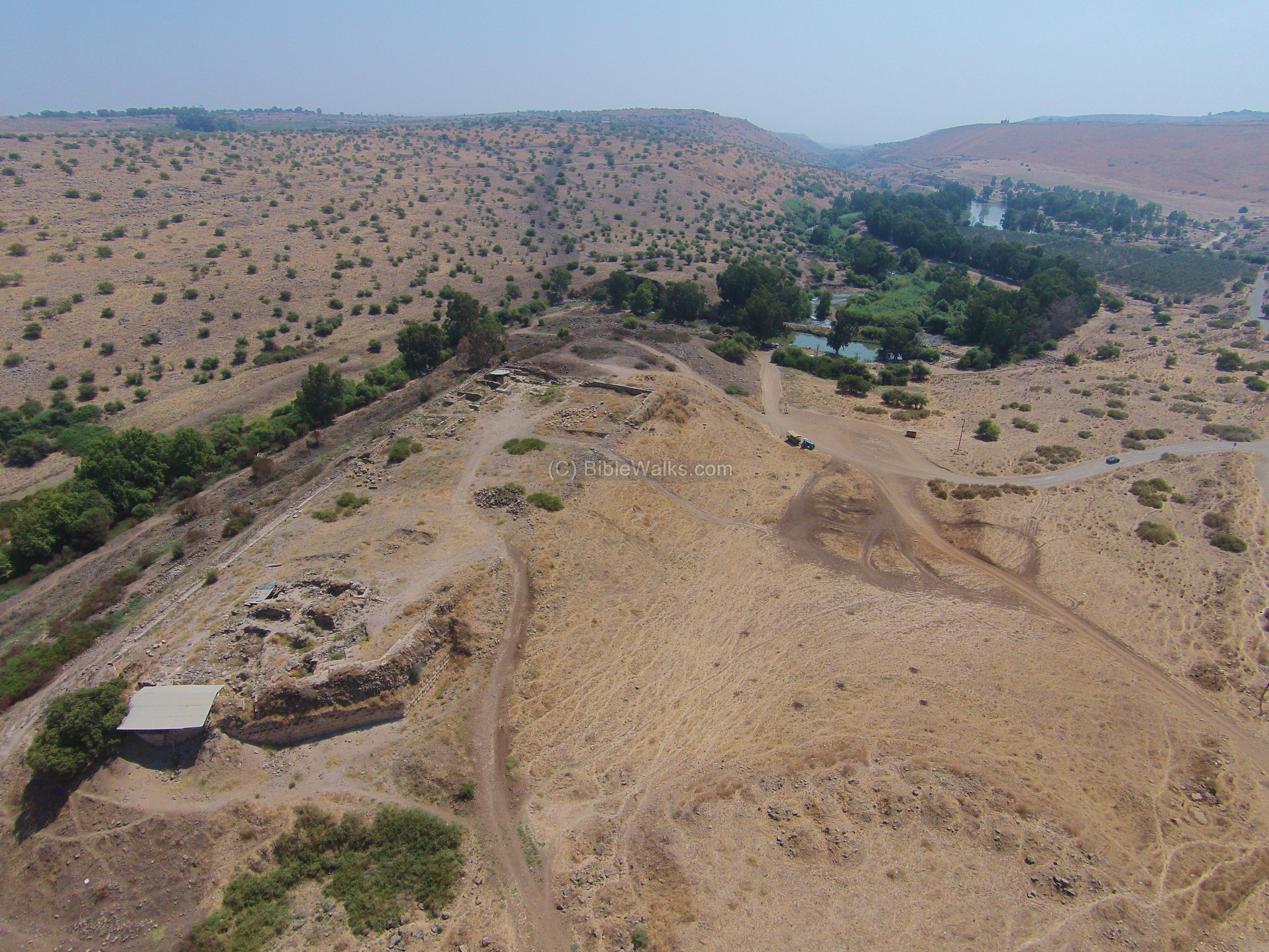 Aerial Drone shot of fortress at Tel Ateret, view from the north
Click on image to open a high res magnifiable image in a new tab
Used with permission from BibleWalks.com
| Transliterated Name | Source | Name |
|---|---|---|
| Tel Ateret | ||
| Metzad ‘Ateret | Hebrew | מצד אטרט |
| Vadum Jacob | Crusader | |
| Vadi Iacob | Latin | |
| Vadum Iacob | Crusader | |
| Chastellet | Crusader | |
| Le Chastelez | 13th century CE | |
| Bayt al-Ahzan | 12th century CE Arabic | بايت الأهزان |
| al-mashhad al-yaʿqūbī | Arabic | |
| makhāḍat al-aḥzā | Arabic | for the Ford - not the castle |
| Qasr al-'Ata | Modern Arabic | قاسر الء'اتا |
| Qasr al-'Atara | Modern Arabic | قاسر الء'اتارا |
| Kaiser Attrah | Anglicized Arabic ? |
- Figure 1b - Location Map
from Ellenblum et al (2015).
 Figure 1b
Location of Ateret on the trace of the Jordan Gorge Fault between the basins of the Hula and the Sea of Galilee. Solid lines mark strike-slip faults; gray lines mark faults at subsurface according to Schattner and Weinberger [2008] and Politi [2011]. Dotted lines mark normal faults. Black arrow west of Ateret shows the location of paleomagnetic declinations and geo-chronology studies of basalt flows that found counterclockwise block rotations about vertical axes of 11.4° ± 4° per million years [Heimann and Ron, 1993].
Base map:GMRT
Ellenblum et al (2015) - Figure 3.1 - Road Map
from Raphael (2023)
 Figure 3.1
The three roads that crossed the Golan Heights and led to Damascus via:
- Banias
- Jacob’s Ford
- Qaṣr Bardawīl (Wadi ʿAlʿāl
(Map by Shai Scharfberg)
Raphael (2023) - Fault Map and Geologic Map
of Tel Ateret area from Vadum Jacob Research Project website.
 Left
Left
Dead Sea Transform zone in the study area, showing main faults (solid lines) and secondary, mostly normal, faults (slim lines).
(partly after Bartov, 1979)
Right
Geologic map of Ateret area showing Pliocene to Pleistocene basalt flows with K-Ar ages (Goren-Inbar and Belitzky, 1989; Heimann and Ron, 1993) , Quaternary lacustrine sediments of Gadot and Benot Ya’akov Formations, and Holocene alluvium (partly after Belitzky, 1987)
Vadum Jacob Research Project website - Figure 18.7 - Hypothesized
fault traces from the 1759 CE Safed and Baalbek Earthquakes from Raphael (2023)
 Figure 18.7
The settlements mentioned by the Damascene chronicles as being struck by the double 1759 earthquake and the assumed rupture zones of the earthquakes. The orange line traces the 25 November mainshock extent, 100 km. long, inferred from the report of the French Consul to Saida.
Raphael (2023)
- Figure 1b - Location Map
from Ellenblum et al (2015).
Figure 1b
Location of Ateret on the trace of the Jordan Gorge Fault between the basins of the Hula and the Sea of Galilee. Solid lines mark strike-slip faults; gray lines mark faults at subsurface according to Schattner and Weinberger [2008] and Politi [2011]. Dotted lines mark normal faults. Black arrow west of Ateret shows the location of paleomagnetic declinations and geo-chronology studies of basalt flows that found counterclockwise block rotations about vertical axes of 11.4° ± 4° per million years [Heimann and Ron, 1993].
Base map:GMRT
Ellenblum et al (2015) - Figure 3.1 - Road Map
from Raphael (2023)
Figure 3.1
The three roads that crossed the Golan Heights and led to Damascus via:
- Banias
- Jacob’s Ford
- Qaṣr Bardawīl (Wadi ʿAlʿāl
(Map by Shai Scharfberg)
Raphael (2023) - Fault Map and Geologic Map
of Tel Ateret area from Vadum Jacob Research Project website.
Left
Dead Sea Transform zone in the study area, showing main faults (solid lines) and secondary, mostly normal, faults (slim lines).
(partly after Bartov, 1979)
Right
Geologic map of Ateret area showing Pliocene to Pleistocene basalt flows with K-Ar ages (Goren-Inbar and Belitzky, 1989; Heimann and Ron, 1993) , Quaternary lacustrine sediments of Gadot and Benot Ya’akov Formations, and Holocene alluvium (partly after Belitzky, 1987)
Vadum Jacob Research Project website - Figure 18.7 - Hypothesized
fault traces from the 1759 CE Safed and Baalbek Earthquakes from Raphael (2023)
Figure 18.7
The settlements mentioned by the Damascene chronicles as being struck by the double 1759 earthquake and the assumed rupture zones of the earthquakes. The orange line traces the 25 November mainshock extent, 100 km. long, inferred from the report of the French Consul to Saida.
Raphael (2023)
- Figure 8.5a - Annotated
Satellite photo (Google Earth) of Tel Ateret – Benot Ya’aqov bridge from Agnon in Garfunkel et al (2014).
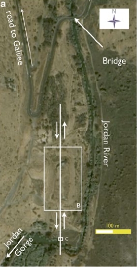 Fig. 8.5a
A satellite photo (Google Earth) of Tel Ateret – Benot Ya’aqov bridge. Vadum Iacob castle straddles the fault trace, that runs through an aqueduct system south of the castle.
JW: White box labeled B encompasses the archaeological site
Agnon in Garfunkel et al (2014) - Annotated Satellite Photo
of Tel Ateret and environs from BibleWalks.com.
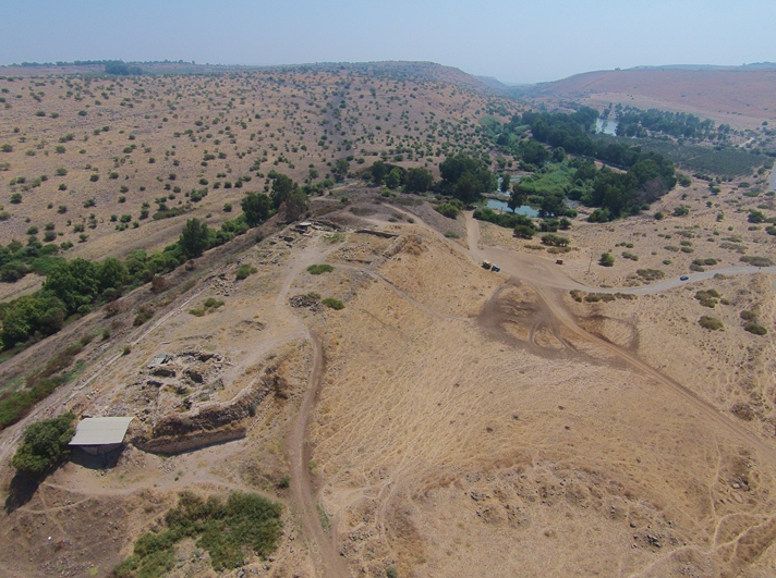
- Figure 4.8 - Aerial View
of fortress from Raphael (2023)
 Figure 4.8
Looking southwest, a stretch of the eastern curtain wall
Raphael (2023) - Aerial view of fortress
at Tel Ateret from BibleWalks.com
 Aerial Drone shot of fortress at Tel Ateret, view from the north
Click on image to open a high res magnifiable image in a new tab
Used with permission from BibleWalks.com - Figure 4.2 - Aerial
View of Tel Ateret from Raphael (2023)
 Figure 4.2
The fortress at Jacob’s Ford
(photo: Itai Hinch SAR Unit Me’voot Ha’hermon)
Raphael (2023) - Tel Ateret in Google Earth
 Tel Ateret
click on image to explore this site on a new tab in Google Earth - Tel Ateret on govmap.gov.il
 Tel Ateret
click on image to explore this site on a new tab in govmap.gov.il

- Figure 8.5a - Annotated
Satellite photo (Google Earth) of Tel Ateret – Benot Ya’aqov bridge from Agnon in Garfunkel et al (2014).
Fig. 8.5a
A satellite photo (Google Earth) of Tel Ateret – Benot Ya’aqov bridge. Vadum Iacob castle straddles the fault trace, that runs through an aqueduct system south of the castle.
JW: White box labeled B encompasses the archaeological site
Agnon in Garfunkel et al (2014) - Annotated Satellite Photo
of Tel Ateret and environs from BibleWalks.com.
- Figure 4.8 - Aerial View
of fortress from Raphael (2023)
Figure 4.8
Looking southwest, a stretch of the eastern curtain wall
Raphael (2023) - Aerial view of fortress
at Tel Ateret from BibleWalks.com
Aerial Drone shot of fortress at Tel Ateret, view from the north
Click on image to open a high res magnifiable image in a new tab
Used with permission from BibleWalks.com - Figure 4.2 - Aerial
View of Tel Ateret from Raphael (2023)
Figure 4.2
The fortress at Jacob’s Ford
(photo: Itai Hinch SAR Unit Me’voot Ha’hermon)
Raphael (2023) - Tel Ateret in Google Earth
Tel Ateret
click on image to explore this site on a new tab in Google Earth - Tel Ateret on govmap.gov.il
Tel Ateret
click on image to explore this site on a new tab in govmap.gov.il
- Figure 4.10 - Site Plan
from Raphael (2023)
 Figure 4.10
Plan of the Templar fortress at Jacob’s Ford The Mamluk–Ottoman mosque is shown in green The capital letters indicate the excavation areas
(plan renewed by Jay Rosenberg)
Raphael (2023) - Figure 2a and b - Plan of
Vadum Jacob fortress with offsets from Ellenblum et al (1998)
 Figure 2
Location of offset human-made linear structures.
- Plan of Vadum Jacob fortress. Solid lines mark well-exposed parts of walls; dotted lines denote unexposed or partly exposed walls.
- Map of southern wall showing displacements and rotations of masonry.
JW: B is a plan view. It is not a cross-section
Ellenblum et al (1998) - Plan of Vadum Jacob fortress
with offsets from Vadum Jacob Research Project website.
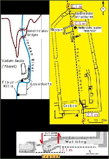 Top-Left
Location map
Top-Right
Plan of Vadum Jacob (Ateret) fortress. Solid lines mark well-exposed parts of walls, dotted lines denote unexposed or partly exposed walls. Note Hellenistic walls terminating at fault zone.
Bottom
Detailed map of the fault zone in the southern wall
Vadum Jacob Research Project website - Figure 1d - Oblique air
photo of site with structures identified from Ellenblum et al (2015).
 Figure 1d
An oblique north looking air-photo showing Tell Ateret. Gray line marks the DSF (ie the Jordan Valley Gorge segment of Dead Sea Transform).
Ellenblum et al (2015)
- Figure 4.10 - Site Plan
from Raphael (2023)
Figure 4.10
Plan of the Templar fortress at Jacob’s Ford The Mamluk–Ottoman mosque is shown in green The capital letters indicate the excavation areas
(plan renewed by Jay Rosenberg)
Raphael (2023) - Figure 2a and b - Plan of
Vadum Jacob fortress with offsets from Ellenblum et al (1998).
Figure 2
Location of offset human-made linear structures.
- Plan of Vadum Jacob fortress. Solid lines mark well-exposed parts of walls; dotted lines denote unexposed or partly exposed walls.
- Map of southern wall showing displacements and rotations of masonry.
JW: B is a plan view. It is not a cross-section
Ellenblum et al (1998) - Plan of Vadum Jacob fortress
with offsets from Vadum Jacob Research Project website.
Top-Left
Location map
Top-Right
Plan of Vadum Jacob (Ateret) fortress. Solid lines mark well-exposed parts of walls, dotted lines denote unexposed or partly exposed walls. Note Hellenistic walls terminating at fault zone.
Bottom
Detailed map of the fault zone in the southern wall
Vadum Jacob Research Project website - Figure 1d - Oblique air
photo of site with structures identified from Ellenblum et al (2015).
Figure 1d
An oblique north looking air-photo showing Tell Ateret. Gray line marks the DSF (ie the Jordan Valley Gorge segment of Dead Sea Transform).
Ellenblum et al (2015)
- Figure 1c - Hellenistic
complex of Tel Ateret from Ellenblum et al (2015).
 Figure 1c
An oblique south looking photomosaic showing the Hellenistic complex during the excavations. The Iron Age wall is marked with blue dots, green dots mark the early Hellenistic wall that we use for measuring displacement, and yellow dots mark a late Hellenistic wall.
Ellenblum et al (2015) - Figure 1e - Hellenistic
walls in the southern part of Tel Ateret from Ellenblum et al (2015).
 Figure 1e
The Hellenistic walls south of the Crusader fortress (pink dotted lines).
The dated Early Hellenistic walls are highlighted with green lines; Late Hellenistic walls with yellow lines.
Ellenblum et al (2015) - Figure 3a - Best Fit
Curves for kinematic analysis in the southern part of Tel Ateret from Ellenblum et al (2015).
 Figure 3a
Map of the excavation in the southern part of Tell Ateret (see Figure 1e for location) showing the best fit curves in red, axes in blue, which we use for the kinematic analysis (equation (2)). In the analysis of deformation above buried faults the walls are assumed originally linear and trending E-W, perpendicular to faults. Angles denote βmax, rotation relatively to E-W. Faults are assumed parallel. Ruptures on the same fault are assumed to reach upward (unlock) to the same depth. Orange circle shows the location of the bronze coin hoard. Blue circles show inset-offset architecture in the Iron Age wall. Black circle shows a 70 cm left-lateral offset of the Iron Age curtain wall that predates the Hellenistic structures. This is a part of the larger offset and bending that exceeds 8 m. Measured elevations are denoted with small digits (m above sea level).
Ellenblum et al (2015) - Figure 4.16 - Plan of
the main gate from Raphael (2023)
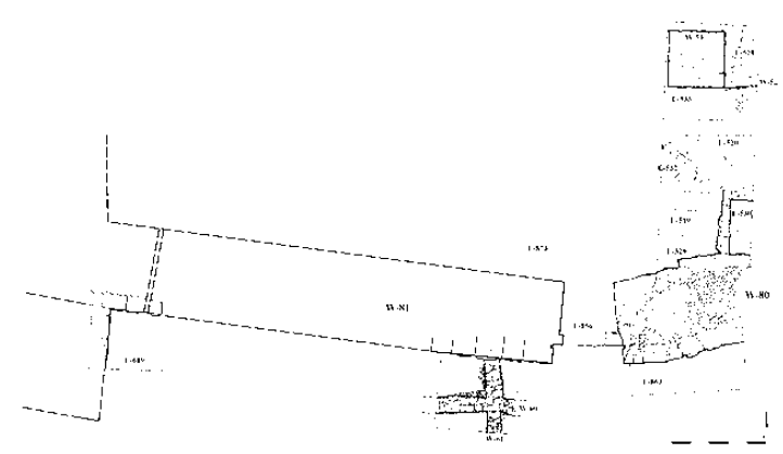 Figure 4.16
Plan of the main gate. The eastern side was partially destroyed by the 1202 earthquake. Smaller walls south of the gate (W60 and W61), date to the Iron Age.
Raphael (2023)
- Figure 1e - Hellenistic
walls in the southern part of Tel Ateret from Ellenblum et al (2015).
Figure 1e
The Hellenistic walls south of the Crusader fortress (pink dotted lines).
The dated Early Hellenistic walls are highlighted with green lines; Late Hellenistic walls with yellow lines.
Ellenblum et al (2015) - Figure 3a - Best Fit
Curves for kinematic analysis in the southern part of Tel Ateret from Ellenblum et al (2015).
Figure 3a
Map of the excavation in the southern part of Tell Ateret (see Figure 1e for location) showing the best fit curves in red, axes in blue, which we use for the kinematic analysis (equation (2)). In the analysis of deformation above buried faults the walls are assumed originally linear and trending E-W, perpendicular to faults. Angles denote βmax, rotation relatively to E-W. Faults are assumed parallel. Ruptures on the same fault are assumed to reach upward (unlock) to the same depth. Orange circle shows the location of the bronze coin hoard. Blue circles show inset-offset architecture in the Iron Age wall. Black circle shows a 70 cm left-lateral offset of the Iron Age curtain wall that predates the Hellenistic structures. This is a part of the larger offset and bending that exceeds 8 m. Measured elevations are denoted with small digits (m above sea level).
Ellenblum et al (2015) - Figure 4.16 - Plan of
the main gate from Raphael (2023)
Figure 4.16
Plan of the main gate. The eastern side was partially destroyed by the 1202 earthquake. Smaller walls south of the gate (W60 and W61), date to the Iron Age.
Raphael (2023)
- Figure 4.9 - E-W section
across the width of the fortress from Raphael (2023)
 Figure 4.9
Schematic west-east section across the width of the fortress
(drawn by Tania Melsten)
Raphael (2023)
- Figure 4.9 - E-W section
across the width of the fortress from Raphael (2023)
Figure 4.9
Schematic west-east section across the width of the fortress
(drawn by Tania Melsten)
Raphael (2023)
Top-LeftLocation map
Top-Right
Plan of Vadum Jacob (Ateret) fortress. Solid lines mark well-exposed parts of walls, dotted lines denote unexposed or partly exposed walls. Note Hellenistic walls terminating at fault zone.
Bottom
Detailed map of the fault zone in the southern wall which shows the location of the trench
Vadum Jacob Research Project website
- Log of a trench wall, parallel southern face of castle. Unit 1, composed of pressed alluvium, and unit 2, a lime pavement, were laid by Crusader masons as wall was built and were used as a ramp for hauling heavy building blocks. Unit 2 was at the surface on the day of the Muslim conquest and provides a horizon precisely dated as 30 August 1179 (dashed solid line). Unit 3 started to accumulate after conquest of castle. The degradation of wall infill is apparent in abundance of basaltic cobbles. Masoned limestone ashlars on left were fallen or tumbled there by Muslims who destroyed castle in 1179. Unit 4 is a cobble-rich, A-soil in which pedogenic processes are intense. Two sets of faults (solid) and shear cracks (slim lines) are evident: One terminates at top of unit 2 or lowermost few centimeters of unit 3; second crosses unit 3 entirely. Active bioturbation in unit 4 hinders preservation of cracks.
- Schematic N-S section in southern wall of castle:
- exterior wall support
- Wall infill of cemented, mainly basaltic, cobbles
- Masoned limestone blocks that fell from exterior wall.
A. Log of a trench wall, parallel southern face of castle.
- Unit 1, composed of pressed alluvium
- Unit 2, a lime pavement, were laid by Crusader masons as wall was built and were used as ramp for hauling heavy building blocks. Unit 2 was at surface on day of Muslim conquest and provides a horizon precisely dated as 30 August 1179 (bold dashed line)
- Unit 3 started to accumulate after conquest of castle. Degradation of wall infill is apparent in abundance of basaltic cobbles. Masoned limestone ashlars on left were fallen or tumbled there by Muslims who destroyed castle in 1179
- Unit 4 is cobble-rich A-soil in which pedogenic processes are intense
B. Schematic north-south section in southern wall of castle:
- exterior wall support
- wall infill of cemented, mainly basaltic, cobbles
- masoned limestone blocks that fell from exterior wall.
Ellenblum et al (1998)
- Figure 4 - Schematic
illustration of stages of slip accrual at Tell Ateret from Ellenblum et al (2015).
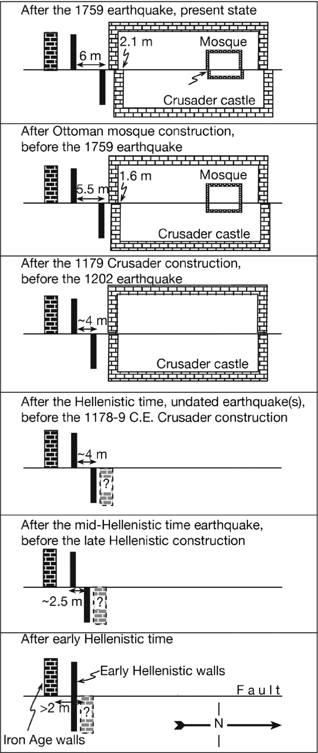 Figure 4
Schematic illustration of the stages of slip accrual (values are rounded) in the Ateret structures, timeline from bottom to top.
Ellenblum et. al. (2015) - Figure 3b - Schematic
illustration of slip history of Tell Ateret from Ellenblum et al (2015).
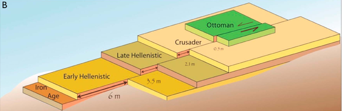 Figure 3b
A schematic illustration of the archaeological strata at Tell Ateret offset by the Dead Sea Fault. The older the strata the larger the offset
Ellenblum et. al. (2015) - Figure 4.37 - Reconstruction
of the kitchen from Raphael (2023)
 Figure 4.37
Reconstruction of the kitchen
(drawn by Tania Meltsen)
Raphael (2023)
- Figure 4 - Schematic
illustration of stages of slip accrual at Tell Ateret from Ellenblum et al (2015).
Figure 4
Schematic illustration of the stages of slip accrual (values are rounded) in the Ateret structures, timeline from bottom to top.
Ellenblum et. al. (2015) - Figure 4.37 - Reconstruction
of the kitchen from Raphael (2023)
Figure 4.37
Reconstruction of the kitchen
(drawn by Tania Meltsen)
Raphael (2023)
- Figure 4.33 - Collapsed vault
from Raphael (2023)
 Figure 4.33
The collapsed vault, sealing the entire gallery (Area E, L456)
Raphael (2023) - Figure 4.36 - Collapsed vault
from Raphael (2023)
 Figure 4.36
Remains of the collapsed vault on the kitchen floor (Area E, looking east)
Raphael (2023) - Figure 4.7 - Collapsed vault
on the kitchen floor in Area E from Raphael (2023)
 Figure 4.7
Remains of the collapsed vault on the kitchen floor in Area E, looking east. Note the ashlar casing and basalt core (marked with yellow arrows)
Raphael (2023) - Figure 4.49 - kitchen and
basalt platform with the remains of the collapsed vault from Raphael (2023)
 Figure 4.49
The kitchen and basalt platform with the remains of the collapsed vault, looking south
Raphael (2023) - Figure 4.15 - Aerial view
of Main Gate from Raphael (2023)
 Figure 4.15
The main gate, looking west
Raphael (2023) - Figure 4.17 - Western wing
of main gate from Raphael (2023)
 Figure 4.17
The main gate, western wing, looking southwest
Raphael (2023) - Figure 4.18 - Eastern wing
of main gate from Raphael (2023)
 Figure 4.18
The main gate, eastern wing, looking southeast, partially destroyed by the 1202 earthquake.
Raphael (2023) - Figure 4.55 - The mosque
from Raphael (2023)
 Figure 4.55
The mosque, looking south
Raphael (2023) - Figure 18.2 - Aerial
photo showing displaced structures from Raphael (2023)
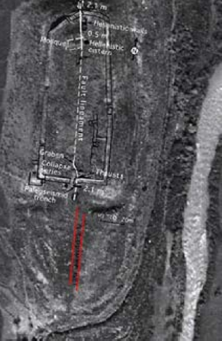 Figure 18.2
An aerial photo of Vadum Iacob showing displacements of structures used in the Crusader period. The fault bisects the castle. The man-made structures are indicated. The walls of the Crusader castle are displaced by 2.1 m, the Mamluk mosque is displaced by 0.5 m and one of the aqueducts (below) is displaced by 1.5 m
Raphael (2023) - Figure 18.3 - Displaced
walls in Area E from Raphael (2023)
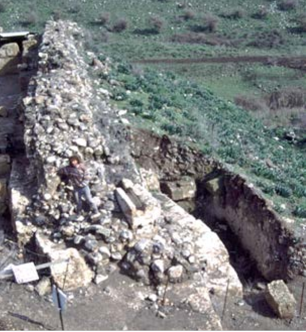 Figure 18.3
Looking east, displacement of the Frankish walls of Vadum Iacob in Area E.
Raphael (2023) - Figure 18.4 - Displaced
northern wall from Raphael (2023)
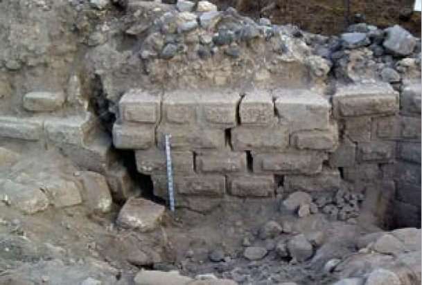 Figure 18.4
The displacement along the northern wall of the fortress. The amount of displacement is identical to that measured along the southern wall.
Raphael (2023) - Figure 18.5 - Displaced
northern wall from Raphael (2023)
 Figure 18.5
Ronnie Ellenblum with a 50 cm. scale bar right after the excavation of the faulted northern wall, in 1994.
Raphael (2023)
- Figure 4.33 - Collapsed vault
from Raphael (2023)
Figure 4.33
The collapsed vault, sealing the entire gallery (Area E, L456)
Raphael (2023) - Figure 4.36 - Collapsed vault
from Raphael (2023)
Figure 4.36
Remains of the collapsed vault on the kitchen floor (Area E, looking east)
Raphael (2023) - Figure 4.7 - Collapsed vault
on the kitchen floor in Area E from Raphael (2023)
Figure 4.7
Remains of the collapsed vault on the kitchen floor in Area E, looking east. Note the ashlar casing and basalt core (marked with yellow arrows)
Raphael (2023) - Figure 4.49 - kitchen and
basalt platform with the remains of the collapsed vault from Raphael (2023)
Figure 4.49
The kitchen and basalt platform with the remains of the collapsed vault, looking south
Raphael (2023) - Figure 4.15 - Aerial view
of Main Gate from Raphael (2023)
Figure 4.15
The main gate, looking west
Raphael (2023) - Figure 4.17 - Western wing
of main gate from Raphael (2023)
Figure 4.17
The main gate, western wing, looking southwest
Raphael (2023) - Figure 4.18 - Eastern wing
of main gate from Raphael (2023)
Figure 4.18
The main gate, eastern wing, looking southeast, partially destroyed by the 1202 earthquake.
Raphael (2023) - Figure 4.55 - The mosque
from Raphael (2023)
Figure 4.55
The mosque, looking south
Raphael (2023) - Figure 18.2 - Aerial
photo showing displaced structures from Raphael (2023)
Figure 18.2
An aerial photo of Vadum Iacob showing displacements of structures used in the Crusader period. The fault bisects the castle. The man-made structures are indicated. The walls of the Crusader castle are displaced by 2.1 m, the Mamluk mosque is displaced by 0.5 m and one of the aqueducts (below) is displaced by 1.5 m
Raphael (2023) - Figure 18.3 - Displaced
walls in Area E from Raphael (2023)
Figure 18.3
Looking east, displacement of the Frankish walls of Vadum Iacob in Area E.
Raphael (2023) - Figure 18.4 - Displaced
northern wall from Raphael (2023)
Figure 18.4
The displacement along the northern wall of the fortress. The amount of displacement is identical to that measured along the southern wall.
Raphael (2023) - Figure 18.5 - Displaced
northern wall from Raphael (2023)
Figure 18.5
Ronnie Ellenblum with a 50 cm. scale bar right after the excavation of the faulted northern wall, in 1994.
Raphael (2023)
- Figure 1e - Hellenistic
walls in the southern part of Tel Ateret from Ellenblum et al (2015).
Figure 1e
The Hellenistic walls south of the Crusader fortress (pink dotted lines).
The dated Early Hellenistic walls are highlighted with green lines; Late Hellenistic walls with yellow lines.
Ellenblum et al (2015) - Figure 3a - Best Fit
Curves for kinematic analysis in the southern part of Tel Ateret from Ellenblum et al (2015).
Figure 3a
Map of the excavation in the southern part of Tell Ateret (see Figure 1e for location) showing the best fit curves in red, axes in blue, which we use for the kinematic analysis (equation (2)). In the analysis of deformation above buried faults the walls are assumed originally linear and trending E-W, perpendicular to faults. Angles denote βmax, rotation relatively to E-W. Faults are assumed parallel. Ruptures on the same fault are assumed to reach upward (unlock) to the same depth. Orange circle shows the location of the bronze coin hoard. Blue circles show inset-offset architecture in the Iron Age wall. Black circle shows a 70 cm left-lateral offset of the Iron Age curtain wall that predates the Hellenistic structures. This is a part of the larger offset and bending that exceeds 8 m. Measured elevations are denoted with small digits (m above sea level).
Ellenblum et al (2015) - Figure 3b - Schematic
illustration of slip history of Tell Ateret from Ellenblum et al (2015).
Figure 3b
A schematic illustration of the archaeological strata at Tell Ateret offset by the Dead Sea Fault. The older the strata the larger the offset
Ellenblum et. al. (2015)
- Figure 2a and b - Plan of
Vadum Jacob fortress with offsets from Ellenblum et al (1998).
Figure 2
Location of offset human-made linear structures.
- Plan of Vadum Jacob fortress. Solid lines mark well-exposed parts of walls; dotted lines denote unexposed or partly exposed walls.
- Map of southern wall showing displacements and rotations of masonry.
JW: B is a plan view. It is not a cross-section
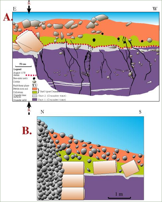
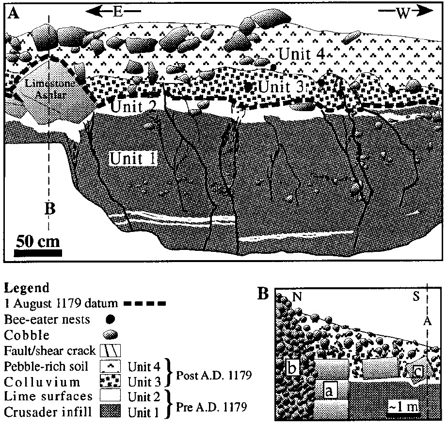
Ellenblum et al (1998) - Figure 3 - Trench Log from
Vadum Jacob fortress from Ellenblum et al (1998)
Figure 3
A. Log of a trench wall, parallel southern face of castle.- Unit 1, composed of pressed alluvium
- Unit 2, a lime pavement, were laid by Crusader masons as wall was built and were used as ramp for hauling heavy building blocks. Unit 2 was at surface on day of Muslim conquest and provides a horizon precisely dated as 30 August 1179 (bold dashed line)
- Unit 3 started to accumulate after conquest of castle. Degradation of wall infill is apparent in abundance of basaltic cobbles. Masoned limestone ashlars on left were fallen or tumbled there by Muslims who destroyed castle in 1179
- Unit 4 is cobble-rich A-soil in which pedogenic processes are intense
B. Schematic north-south section in southern wall of castle:- exterior wall support
- wall infill of cemented, mainly basaltic, cobbles
- masoned limestone blocks that fell from exterior wall.
Ellenblum et al (1998) - Trench Log in color from
Vadum Jacob Research Project website.
- Log of a trench wall, parallel southern face of castle. Unit 1, composed of pressed alluvium, and unit 2, a lime pavement, were laid by Crusader masons as wall was built and were used as a ramp for hauling heavy building blocks. Unit 2 was at the surface on the day of the Muslim conquest and provides a horizon precisely dated as 30 August 1179 (dashed solid line). Unit 3 started to accumulate after conquest of castle. The degradation of wall infill is apparent in abundance of basaltic cobbles. Masoned limestone ashlars on left were fallen or tumbled there by Muslims who destroyed castle in 1179. Unit 4 is a cobble-rich, A-soil in which pedogenic processes are intense. Two sets of faults (solid) and shear cracks (slim lines) are evident: One terminates at top of unit 2 or lowermost few centimeters of unit 3; second crosses unit 3 entirely. Active bioturbation in unit 4 hinders preservation of cracks.
- Schematic N-S section in southern wall of castle:
- exterior wall support
- Wall infill of cemented, mainly basaltic, cobbles
- Masoned limestone blocks that fell from exterior wall.
Vadum Jacob Research Project website - Figure 2c - Photo of deformation
in northern wall of Castle of Vadum Jacob from Ellenblum et al (1998)
 Figure 2c
Photo of deformation in northern wall of Castle of Vadum Jacob. Line marks prefaulting location of wall.
Ellenblum et al (1998) - Figure 3 - Faulted wall
of the Ottoman mosque from Marco (2009)
 Figure 3
Picture taken in 1994, before the excavation.
Marco (2009)
- Figure 3 - Faulted wall
of the Ottoman mosque from Marco (2009)
Figure 3
Picture taken in 1994, before the excavation.
Marco (2009)
LeftFigure 4
Schematic illustration of the stages of slip accrual (values are rounded) in the Ateret structures, timeline from bottom to top.
Right
Figure 3b
A schematic illustration of the archaeological strata at Tell Ateret offset by the Dead Sea Fault. The older the strata the larger the offset
Both Figures from Ellenblum et. al. (2015)
| Effect | Location | Image(s) | Description(s) |
|---|---|---|---|
| Folded and displaced walls | immediately south of the faulted Crusader wall
Figure 2 Location of offset human-made linear structures.
JW: B is a plan view. It is not a cross-section Ellenblum et al (1998) |
Figure 1e The Hellenistic walls south of the Crusader fortress (pink dotted lines). The dated Early Hellenistic walls are highlighted with green lines; Late Hellenistic walls with yellow lines. Ellenblum et al (2015)
Figure 3aMap of the excavation in the southern part of Tell Ateret (see Figure 1e for location) showing the best fit curves in red, axes in blue, which we use for the kinematic analysis (equation (2)). In the analysis of deformation above buried faults the walls are assumed originally linear and trending E-W, perpendicular to faults. Angles denote βmax, rotation relatively to E-W. Faults are assumed parallel. Ruptures on the same fault are assumed to reach upward (unlock) to the same depth. Orange circle shows the location of the bronze coin hoard. Blue circles show inset-offset architecture in the Iron Age wall. Black circle shows a 70 cm left-lateral offset of the Iron Age curtain wall that predates the Hellenistic structures. This is a part of the larger offset and bending that exceeds 8 m. Measured elevations are denoted with small digits (m above sea level). Ellenblum et al (2015) |
|
| Debris and fallen stones indicating wall damage | South of the faulted Crusader wall ?
Figure 2 Location of offset human-made linear structures.
JW: B is a plan view. It is not a cross-section Ellenblum et al (1998) |
|
| Effect | Location | Image(s) | Description(s) |
|---|---|---|---|
| Offset walls | southern and northern defense walls
Figure 2 Location of offset human-made linear structures.
JW: B is a plan view. It is not a cross-section Ellenblum et al (1998) |
Figure 2c Photo of deformation in northern wall of Castle of Vadum Jacob. Line marks prefaulting location of wall. Ellenblum et al (1998) |
|
| Graben | North of the southern main gate
Figure 2 Location of offset human-made linear structures.
JW: B is a plan view. It is not a cross-section Ellenblum et al (1998) |
|
| Effect | Location | Image(s) | Description(s) |
|---|---|---|---|
| Offset walls | A Muslim-style room interpreted as a mosque
Figure 2 Location of offset human-made linear structures.
JW: B is a plan view. It is not a cross-section Ellenblum et al (1998) |
Figure 3 Picture taken in 1994, before the excavation. Marco (2009) |
|
| Fallen stones suggesting some wall collapse | A Muslim-style room interpreted as a mosque
Figure 2 Location of offset human-made linear structures.
JW: B is a plan view. It is not a cross-section Ellenblum et al (1998) |
|
- Lightly modified by JW from Fig. 3a of Ellenblum et al (2015)
- some offset is due to later earthquakes
 Deformation Map
lightly modified by JW from Fig. 3a of Ellenblum et al (2015)
- Modified by JW from Fig. 2a of Ellenblum et al (1998)
 Deformation Map
modified by JW from Fig. 2a of Ellenblum et al (1998)
- Modified by JW from Fig. 2a of Ellenblum et al (1998)
 Deformation Map
modified by JW from Fig. 2a of Ellenblum et al (1998)
- Earthquake Archeological Effects chart
of Rodríguez-Pascua et al (2013: 221-224)
 Earthquake Archeological Effects (EAE)
Rodríguez-Pascua et al (2013: 221-224)
| Effect | Location | Image(s) | Description(s) | Intensity |
|---|---|---|---|---|
| Folded and displaced walls | immediately south of the faulted Crusader wall
Figure 2 Location of offset human-made linear structures.
JW: B is a plan view. It is not a cross-section Ellenblum et al (1998) |
Figure 1e The Hellenistic walls south of the Crusader fortress (pink dotted lines). The dated Early Hellenistic walls are highlighted with green lines; Late Hellenistic walls with yellow lines. Ellenblum et al (2015)
Figure 3aMap of the excavation in the southern part of Tell Ateret (see Figure 1e for location) showing the best fit curves in red, axes in blue, which we use for the kinematic analysis (equation (2)). In the analysis of deformation above buried faults the walls are assumed originally linear and trending E-W, perpendicular to faults. Angles denote βmax, rotation relatively to E-W. Faults are assumed parallel. Ruptures on the same fault are assumed to reach upward (unlock) to the same depth. Orange circle shows the location of the bronze coin hoard. Blue circles show inset-offset architecture in the Iron Age wall. Black circle shows a 70 cm left-lateral offset of the Iron Age curtain wall that predates the Hellenistic structures. This is a part of the larger offset and bending that exceeds 8 m. Measured elevations are denoted with small digits (m above sea level). Ellenblum et al (2015) |
|
VII+ |
| Debris and fallen stones indicating wall damage and collapse | South of the faulted Crusader wall ?
Figure 2 Location of offset human-made linear structures.
JW: B is a plan view. It is not a cross-section Ellenblum et al (1998) |
|
VIII+ |
- Earthquake Archeological Effects chart
of Rodríguez-Pascua et al (2013: 221-224)
Earthquake Archeological Effects (EAE)
Rodríguez-Pascua et al (2013: 221-224)
| Effect | Location | Image(s) | Description(s) | Intensity |
|---|---|---|---|---|
| Displaced Walls - Offset walls | southern and northern defense walls
Figure 2 Location of offset human-made linear structures.
JW: B is a plan view. It is not a cross-section Ellenblum et al (1998) |
Figure 2c Photo of deformation in northern wall of Castle of Vadum Jacob. Line marks prefaulting location of wall. Ellenblum et al (1998) |
|
VII+ |
| Graben - seismic uplift/subsidence | North of the southern main gate
Figure 2 Location of offset human-made linear structures.
JW: B is a plan view. It is not a cross-section Ellenblum et al (1998) |
|
VI+ |
- Earthquake Archeological Effects chart
of Rodríguez-Pascua et al (2013: 221-224)
Earthquake Archeological Effects (EAE)
Rodríguez-Pascua et al (2013: 221-224)
| Effect | Location | Image(s) | Description(s) | Intensity |
|---|---|---|---|---|
| Displaced Walls - Offset walls | A Muslim-style room interpreted as a mosque
Figure 2 Location of offset human-made linear structures.
JW: B is a plan view. It is not a cross-section Ellenblum et al (1998) |
Figure 3 Picture taken in 1994, before the excavation. Marco (2009) |
|
VII+ |
| Fallen stones suggesting some wall collapse | A Muslim-style room interpreted as a mosque
Figure 2 Location of offset human-made linear structures.
JW: B is a plan view. It is not a cross-section Ellenblum et al (1998) |
|
VIII+ |