| Text (with hotlink) | Original Language | Biographical Info | Religion | Date of Composition | Location Composed | Notes |
|---|---|---|---|---|---|---|
| Damage and Chronology Reports from Textual Sources | n/a | n/a | n/a | n/a | n/a | n/a |
| al-Nuwairi | Arabic |
|
Muslim ? | between 1312 and 1333 CE | Cairo | States that between 11 Jan. 1293 and 8 Feb. 1293 CE there was a violent earthquake at the towns of Gaza, Ramla, Ludd [Lydda], and Karakwith the Karak particularly affected and three towers of the citadel [of Karak] were destroyed. |
| Ibn Kathir | Arabic |
|
Muslim | Before 1373 CE | Damascus | States that between 11 Jan. 1293 and 8 Feb. 1293 CE there was an earthquake at Karak and many buildings were destroyed at Tafila. |
| Ibn al-Furat | Arabic |
|
Muslim | before 1405 CE | Egypt | States that between 11 Jan. 1293 and 8 Feb. 1293 CE a vigorous earthquake occurred in the area of Ghaza, Ramleh, Lydda and Kerakwith the worst damage at Kerak where three towers of the fortress were ruined. Also states that it was particularly destructive along the coast, ruined many places, and damaged the minarets of the Mosques in Ramla and Ghaza. |
| Ibn al-Jazari | Arabic |
|
Muslim | before 1429 CE | ? | States that between 11 Jan. 1293 and 8 Feb. 1293 CE there was a violent earthquake in the towns of Gaza, Ramla, Ludd [Lydda], Qaqun and Karakwith the worst damage at Kerak where three towers of the citadel were destroyed along with many houses. |
| al-Maqrizi | Arabic |
|
Sunni Muslim Shafi‘i (Rabbat, 2003:9) | before 1442 CE | Cairo or Damascus | States that between 11 Jan. 1293 and 8 Feb. 1293 CE the towns of Ghaza, Ramla, Ludd and especially Al-Karak, were struck by a violent earthquakeand that three towers in Karak were destroyed. Also states that a tremendous earthquake struck the coastal towns, the earthquake caused destruction in many places, and the minaret of the congregational mosque at Ramla was so badly cracked that it collapsed. |
| as-Suyuti | Arabic |
|
Sufi Muslim | 15th c. CE | Cairo | States that between 11 Jan. 1293 and 8 Feb. 1293 CE Ramla, Fakul, and Karakwere destroyed in an earthquake. |
| Text (with hotlink) | Original Language | Biographical Info | Religion | Date of Composition | Location Composed | Notes |
| Aliases | Arabic |
|---|---|
| Al-Suyuti | |
| As-Suyuti | |
| Jalal al-Din al-Suyuti | |
| Abu 'l-Fadl 'Abd al-Rahman ibn Abi Bakr ibn Muhammad Djalal al_Din al-Khudayri |


| Year | Reference | Corrections | Notes |
|---|---|---|---|
| 11 Jan. 1293 - 8 Feb. 1293 CE | Safar A.H. 692 | none | Calculated using CHRONOS |
| Location (with hotlink) | Status | Intensity | Notes |
|---|---|---|---|
| Amman Citadel | possible | needs investigation | |
| Karak | Rebuilding efforts reported by some authors soon after the earthquake struck may have removed destruction evidence leaving rebuilding evidence instead. | ||
| Jericho - Introduction | n/a | n/a | n/a |
| Jericho - Hisham's Palace | probable | ≥ 8 9-10 |
Later Earthquake -
Alfonsi et al (2013) dated the causitive earthquake for the major seismic destruction at Hisham's Palace to the earthquake of 1033 CE unlike previous
researchers who dated it to one of the Sabbatical Year earthquakes. Their discussion is reproduced below:
The archaeological data testify to an uninterrupted occupancy from eighth century until 1000 A.D. of the Hisham palace (Whitcomb, 1988). Therefore, if earthquakes occurred in this time period, the effects should not have implied a total destruction with consequent occupancy contraction or abandonment. Toppled walls and columns in the central court cover debris containing 750-850 A.D. old ceramic shards (Whitcomb, 1988). Recently unearthed collapses north of the court confirm a widespread destruction after the eighth century (Jericho Mafjar Project - The Oriental Institute at the University of Chicago). These elements support the action of a destructive shaking event at the site later than the 749 A.D. earthquake. The two well-constrained, major historical earthquakes recognized in the southern Jordan Valley are the 749 and 1033 A.D. (Table 1; Marco et al (2003); Guidoboni and Comastri, 2005). We assign an IX—X intensity degree to the here-recorded Hisham damage, whereas a VII degree has been attributed to the 749 A.D. earthquake at the site (Marco et al, 2003). Furthermore, Whitcomb (1988) defines an increment of occupation of the palace between 900 and 1000 A.D. followed by a successive occupation in the 1200-1400 A.D. time span. On the basis of the above, and because no pottery remains are instead associated with the 1000-1200 A.D. period at Hisham palace (Whitcomb, 1988), we suggest a temporary, significant contraction or abandonment of the site as consequence of a severe destruction in the eleventh century. |
| Petra - Introduction | n/a | n/a | n/a |
| Petra - Jabal Harun | possible | ≥ 8 | Phase 12 destruction event - not well dated -
Mikkola et al (2008) noted that in this destruction event all remaining roof structures collapsed and there was a layer of stone tumble. Hard-packed, clayey soil directly under the lowermost deposits of stone tumble [...] contained relatively few findsapparently making it difficult to date. Also found in the stone tumble were the remains of two fallen arches, a row of voussoirs, some drums fallen froma column, and many other architectural elements found throughout the complex. |
| Petra - Petra Church | possible | ≥ 8 | Fiema et al (2001) characterized structural destruction of the church in Phase X as likely caused by an
earthquake with a date that is not easy to determine. A very general terminus post quemof the early 7th century CE was provided. Destruction due to a second earthquake was identified in Phase XIIA which was dated from late Umayyad to early Ottoman. Taken together this suggests that the first earthquake struck in the 7th or 8th century CE and the second struck between the 8th and 16th or 17th century CE. |
| Petra - Blue Chapel and the Ridge Church | possible | Later undated earthquake(s)- Perry in Bikai et al (2020:70) noted that from the 8th c. A.D. on, the abandoned structures suffered extensive damage from repeated earthquakes. |
|
| Shivta | possible | ≥ 8 | Post Abandonment Earthquake(s) - 8th - 15th centuries CE - On the western perimeter of Shivta in Building 121,
Erickson-Gini (2013) found evidence of earthquake induced collapse of the ceilings and parts of the wallswhich she dated to possibly in the Middle Islamic periodafter the site was abandoned at the end of the Early Islamic period.Collapsed arches were also found. The arches appear to be in a crescent pattern. Erickson-Gini (2013) discussed dating of the structure is as follows: The excavation revealed that the structure was built and occupied in the Late Byzantine period (fifth–seventh centuries CE) and continued to be occupied as late as the Early Islamic period (eighth century CE). The structure appears to have collapsed sometime after its abandonment, possibly in the Middle Islamic period.Dateable artifacts in Room 2 came from the Late Byzantine period and the Early Islamic period (eighth century CE). The terminus ante quem for this earthquake is not well established. Korjenkov and Mazor (1999a) report that a site effect is not likely at this location. |
| Baydha | possible | ≥ 8 | Western Mosque Earthquake - 11th-13th centuries CE -
Sinibaldi (2018:75) reports that Mosque 2 (aka the Western Mosque) was probably destroyed by an earthquake.Sinibaldi (2023:360) reports that 14C analysis of archaeobotanical materials recovered from surfaces of useof mosques 1 and 2 produced preliminary results which dated the samples from the two mosques between the eleventh and the thirteenth centuriesCE. |
| el-Lejjun | possible | ≥ 8 | 4th Earthquake - ~600 CE - 1918 CE - Groot et al (2006:183) report discovery of a
nearly complete Umayyad Lamp in Square 4 of Area B (Barracks - B.6.038) in the Post Stratum Gap - above and later than the 3rd earthquake layer.
Above the Ummayyad lamp was a 0.7 m thick layer of tumble containing some roof beams and many wall blocks(Groot et al, 2006:183). They note that the basalt roof beams found embedded in the lowest tumble level (B.6.032) suggests initial massive destruction rather than gradual decay over time. The wall blocks, found in the upper layer of tumble, contained one late Islamic (1174-1918 CE) and one Ayyubid/Mamluk (1174-1516 CE) sherd indicating a significant amount of time may have passed between the possibly seismically induced roof collapse and the wall collapse which was not characterized as necessarily having a seismic origin. This opens up the possibility that one of the mid 8th century CE earthquakes or a later earthquake may have also caused damage at el-Lejjun. deVries et al (2006:196) suggests that Umayyad abandonment of the northwest tower was probably triggered by further major collapse. In the North Gate, deVries et al (2006:207) found evidence of full scale destruction in layers above 3rd earthquake debris and post-earthquake occupation layerswhich contained Late Byzantine/Umayyad and Umayyad sherds. Subsoil/tumble was found in C.9.008 (north room), C.9.009 (south room) and C.9.005 (stairwell) bear ample witness to the destruction of the rooms, perhaps in the Umayyad period. Although Late Byzantine sherds were found in Post Stratum layers in the North Gate, if one assumes that the 3rd earthquake was the Inscription at Aeropolis Quake which struck before 597 CE - probably within a decade of 597 CE, one can establish an approximate and fairly conservative terminus post quem for this earthquake of ~600 CE. While the terminus ante quem is the end of the post stratum III gap (1918 CE), it is probable that that the earthquake struck much earlier. |
| Castellum of Qasr Bshir | possible | ≥ 8 | Later Earthquake(s) - Above what was presumed to be a Late Umayyad collapse layer
Clark (1987:490) found another collapse layer in H.2
A period of abandonment followed [the Late Umayyad collapse], punctuated by a squatter occupation of the room, during which a fire was lit in the corner. There followed a major collapse of masonry, after which no further occupation of the room took place. |
| Location (with hotlink) | Status | Intensity | Notes |
| Location (with hotlink) | Status | Intensity | Notes | ||||||||||||||||||||||||||||
|---|---|---|---|---|---|---|---|---|---|---|---|---|---|---|---|---|---|---|---|---|---|---|---|---|---|---|---|---|---|---|---|
| Jordan Valley - Tell Saidiyeh and Ghor Kabed Trenches | possible | ≥ 7 | Ferry et al (2011) detected 12 surface rupturing seismic events in 4 trenches (T1-T4) in Tell Saidiyeh and Ghor Kabed; 10 of which were prehistoric. The tightest chronology came from the Ghor Kabed trenches (T1 and T2) where Events Y and Z were constrained to between 560 and 1800 CE. | ||||||||||||||||||||||||||||
| Dead Sea - Seismite Types | n/a | n/a | n/a | ||||||||||||||||||||||||||||
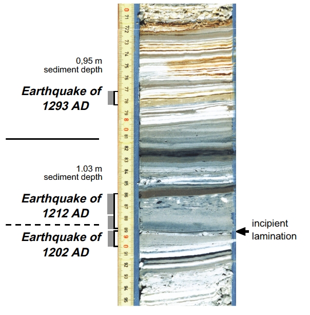
| Dead Sea - En Feshka | possible to probable | 8.2 - 9.0 (0 cm.) 8.1 - 8.9 (12 cm.) 8.0 - 8.8 (28 cm.) |
Kagan et. al. (2011)
identified several seismites from around this time.
|
||||||||||||||||||||||||||||
| Dead Sea - En Gedi | possible | 7.9 - 8.8 |
|
||||||||||||||||||||||||||||
| Dead Sea - Nahal Ze 'elim | possible | 8.3 - 9.1 | At site ZA-1, Ken-Tor et al (2001a) assigned a a date of 1293 CE to a ~15 cm. thick Type 4 seismite which they labeled as Event F and was dated between 1270 and 1400 CE (± 2σ). In Table 4 of Kagan et. al. (2011), a 16 cm. thick seismite at ZA-1 was associated with the 1293 CE earthquake. At site ZA-2, Kagan et. al. (2011) did not find any seismites whose time window encompassed 1293 CE. | ||||||||||||||||||||||||||||
| Araba - Introduction | n/a | n/a | n/a | ||||||||||||||||||||||||||||
| Araba - Taybeh Trench | possible | LeFevre et al. (2018) assigned a 1293 CE date to a seismite labeled as E3supp (aka E3bis) which was age modeled to between 819 and 1395 CE. | |||||||||||||||||||||||||||||
| Araba - Qatar Trench | possible | ≥ 7 | Klinger et. al. (2015) identified one seismic event which might fit.
|
||||||||||||||||||||||||||||
| Araba - Taba Sabhka Trench | possible | ≥ 7 | Allison (2013) assigned a 1068 CE date to a seismic event which they dated to between 1045 and 1661 CE and Allison (2013) assigned a 1212 CE date to a seismic event which they dated to between the mid 11th century CE and the 16-17th centuries CE. | ||||||||||||||||||||||||||||
| Araba - Elat Sabhka Trenches | possible | Kanari et al (2020) suggested that a dewatering structure (aka a liquefaction fluid escape structure) found in Trench T1 and dated to before 1269-1389 CE was caused by the 1068 CE Quake(s) or the 1212 CE Quake. Kanari et al (2020) also dated Event E2 in Trench T3 to after 1294 CE and assigned it to earthquakes in 1458 or 1588 CE. Kanari et al (2020) dated sand blows SB1 and SB2 in Trench T3 to between 1287 and 1635 CE and suggested they may have formed during an earthquake in 1458 CE. | |||||||||||||||||||||||||||||
| Araba - Trenches in Aqaba | possible | ≥ 7 |
Niemi (2011:153) noted that the most recent scarp-forming event fault [in Trench AQ-1] occurred after A.D. 1045-1278 based on a corrected, calibrated radiocarbon age from charcoal collected from a buried campfire at the base of the scarp in Trench T-1. This likely represents fault motion in one of the historical earthquakes affecting southern Jordan (e.g. 1068, 1212, 1458, or 1588). |
||||||||||||||||||||||||||||
| Location (with hotlink) | Status | Intensity | Notes |
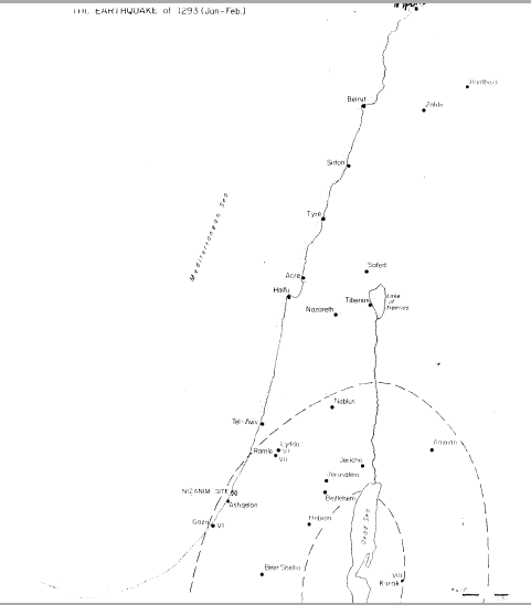
Figure 10
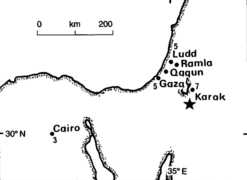
Fig. 2.13 1293 January, Dead Sea. (Ambraseys et al, 1994)
1293 January Safar 692 Dead Sea
A strong earthquake occurred in the region of Ghazza
(Gaza), affecting al-Ramla, Ludd, Qaqun and al-Karak
- particularly the latter, where three towers of the citadel
were destroyed and many houses (see Figure 2.13).1
In al-Ramla, the earthquake followed a destructive flood.
The earthquake ruined many places in coastal Palestine
and the minaret of the main mosque at al-Ramla
fissured and fell; the minaret at Gaza also collapsed.
Orders were given to assess the damage in both places,
and a team was sent from Damascus to repair the damage to al-Karak.2
Al-Suyuti says that the following year, 693/1294, an
earthquake that affected all Egypt caused some pillars
in the mosque of 'Amr (in Fustat) to became partially
detached, but this was less serious than what happened
in the main mosque in Cairo.3 It is very likely that the
same earthquake is involved. No earlier confirmation of
the earthquake in Egypt has yet been found.4
5. THE EARTHQUAKE OF 1293
a. Sources
This was a destructive earthquake. Ibn al-Furat writes (Ta'rikh,
Beirut, 1939, vol. VII, p. 154):
In the month of Safar (12th January - 9th February) a vigorous earthquake occurred in the area of Ghaza, Ramleh, Lydda and Kerak. It was most heavily felt in Kerak where three towers of the for less were ruined ... It was particularly destructive along the coast. It ruined many places. The minaret of the Friday mosque.of Ramleh cracked and collapsed ... as well as the minaret of Ghaza.b. Estimated Seismic Intensities and Epicenter
| Site | Damage | Estimated Max I (MMS) |
|---|---|---|
| Kerak | Three fortress towers destroyed | VIII |
| Ramleh | Mosque's minaret cracked | VII |
| Lydda | No damage reported | VI |
| Ghaza | Mosque's minaret cracked | VII |