| Text (with hotlink) | Original Language | Religion | Date of Composition | Location Composed | Notes |
|---|---|---|---|---|---|
| Damage and Chronology Reports from Textual Sources | n/a | n/a | n/a | n/a | n/a |
| Abu Shama | Arabic | Sunni Muslim | before 1268 CE | Damascus | States that on the night of 1 May 1212 CE [year assumed] there was a tremendous earthquake which destroyed many parts of old and new Cairowhile adding that it also destroyed towers and houses at Al- Karak and Shubakand many women and children died in the ruins. Abu Shama also said that the most violent shock was at Aylat, on the coastand added that it was said that the earthquake was preceded by a black wind and many falling stars. |
| Ibn Kathir | Arabic | Muslim | Before 1373 CE | Damascus | States that there was a very violent earthquake in Egypt and at Cairo, and many houses were destroyedadding that the same thing happened at Al-Karak and Shubak, and some of its citadel towers were destroyedand many women and children died in the ruins. |
| al-Maqrizi | Arabic | Sunni Muslim Shafi‘i (Rabbat, 2003:9) | before 1442 CE | Cairo or Damascus | States that there was a violent earthquake in Egypt and at Cairo, and many houses were destroyedadding that there was also an earthquake at Al-Karak and Shubak and many people died in the ruins and a number of towers in its citadel were destroyed.States that smoke was seen coming down from heaven to earth in Damascus between dusk and evening. |
| as-Suyuti | Arabic | Sufi Muslim | 15th c. CE | Cairo | States that in A.H. 608 (15 June 1211 - 2 June 1212 CE)
there was a violent earthquake in Egypt and at Cairo, and many houses were destroyedadding that there was also an earthquake at Al-Karak and Shubak, and some towers in its citadel were destroyed and many people died in the ruins.States that smoke was seen to come down from heaven to earth between dusk and evening at the tomb of Atika in the western part of Damascus.. |
| Nectarius of Jerusalem | Greek | Greek Orthodox Christian | before 1680 CE | Jerusalem ? | Nectarius of Jerusalem wrote that Saint Catherine's Monastery in the Sinai
experienced two foreshocks at sunset and midnight on Monday 30 April 1212 CE and a damaging main shock at dawn of Tuesday
1 May 1212 CE. Rockfalls from the surrounding mountains were described and there was damage to the northern and eastern walls. Walls were so damaged that
it was possible to pass a loaded animal through them. He also reported that two towers of the Monastery collapsed and
some of the cells collapsed completely but in others only the roofs collapsed. Aftershocks were also described. Triantafyllou et al. (2022:13) reports that in another passage Nectarius related that six days after the earthquake a group of seven Christian builders arrived and repaired the Monastery walls and towers 'in the situation they can be found today' [quote from Nectarios]. Triantafyllou et al. (2022:13) added that the builders happened to arrive there for another reason, i.e., to renovate the Church at the Holly Summit of the Mountain since it suffered damage from past earthquakes. Although Nectarius provided a year of 1312 CE, this was typographic error either by him or his source. Other sources (Abu Shama and al-Suyuti) specify the year as 1212 CE and the day of the week and dates provided in Nectarius' narration are in agreement in 1212 CE but not in 1312 CE. |
| Text (with hotlink) | Original Language | Religion | Date of Composition | Location Composed | Notes |
| Location (with hotlink) | Status | Intensity | Notes |
|---|---|---|---|
| Jericho - Introduction | n/a | n/a | n/a |
| Jericho - Hisham's Palace | probable | ≥ 8 9-10 |
Later Earthquake -
Alfonsi et al (2013) dated the causitive earthquake for the major seismic destruction at Hisham's Palace to the earthquake of 1033 CE unlike previous
researchers who dated it to one of the Sabbatical Year earthquakes. Their discussion is reproduced below:
The archaeological data testify to an uninterrupted occupancy from eighth century until 1000 A.D. of the Hisham palace (Whitcomb, 1988). Therefore, if earthquakes occurred in this time period, the effects should not have implied a total destruction with consequent occupancy contraction or abandonment. Toppled walls and columns in the central court cover debris containing 750-850 A.D. old ceramic shards (Whitcomb, 1988). Recently unearthed collapses north of the court confirm a widespread destruction after the eighth century (Jericho Mafjar Project - The Oriental Institute at the University of Chicago). These elements support the action of a destructive shaking event at the site later than the 749 A.D. earthquake. The two well-constrained, major historical earthquakes recognized in the southern Jordan Valley are the 749 and 1033 A.D. (Table 1; Marco et al (2003); Guidoboni and Comastri, 2005). We assign an IX—X intensity degree to the here-recorded Hisham damage, whereas a VII degree has been attributed to the 749 A.D. earthquake at the site (Marco et al, 2003). Furthermore, Whitcomb (1988) defines an increment of occupation of the palace between 900 and 1000 A.D. followed by a successive occupation in the 1200-1400 A.D. time span. On the basis of the above, and because no pottery remains are instead associated with the 1000-1200 A.D. period at Hisham palace (Whitcomb, 1988), we suggest a temporary, significant contraction or abandonment of the site as consequence of a severe destruction in the eleventh century. |
| Petra - Introduction | n/a | n/a | n/a |
| Petra - Jabal Harun | possible | ≥ 8 | Phase 12 destruction event - not well dated -
Mikkola et al (2008) noted that in this destruction event all remaining roof structures collapsed and there was a layer of stone tumble. Hard-packed, clayey soil directly under the lowermost deposits of stone tumble [...] contained relatively few findsapparently making it difficult to date. Also found in the stone tumble were the remains of two fallen arches, a row of voussoirs, some drums fallen froma column, and many other architectural elements found throughout the complex. |
| Petra - Petra Church | possible | ≥ 8 | Fiema et al (2001) characterized structural destruction of the church in Phase X as likely caused by an
earthquake with a date that is not easy to determine. A very general terminus post quemof the early 7th century CE was provided. Destruction due to a second earthquake was identified in Phase XIIA which was dated from late Umayyad to early Ottoman. Taken together this suggests that the first earthquake struck in the 7th or 8th century CE and the second struck between the 8th and 16th or 17th century CE. |
| Petra - Blue Chapel and the Ridge Church | possible | Later undated earthquake(s)- Perry in Bikai et al (2020:70) noted that from the 8th c. A.D. on, the abandoned structures suffered extensive damage from repeated earthquakes. |
|
| Saint Catherine's Monastery In Sinai | no evidence | There is no archaeoseismic evidence that I am aware of although there is Textual evidence | |
| Shivta | possible | ≥ 8 | Post Abandonment Earthquake(s) - 8th - 15th centuries CE - On the western perimeter of Shivta in Building 121,
Erickson-Gini (2013) found evidence of earthquake induced collapse of the ceilings and parts of the wallswhich she dated to possibly in the Middle Islamic periodafter the site was abandoned at the end of the Early Islamic period.Collapsed arches were also found. The arches appear to be in a crescent pattern. Erickson-Gini (2013) discussed dating of the structure is as follows: The excavation revealed that the structure was built and occupied in the Late Byzantine period (fifth–seventh centuries CE) and continued to be occupied as late as the Early Islamic period (eighth century CE). The structure appears to have collapsed sometime after its abandonment, possibly in the Middle Islamic period.Dateable artifacts in Room 2 came from the Late Byzantine period and the Early Islamic period (eighth century CE). The terminus ante quem for this earthquake is not well established. Korjenkov and Mazor (1999a) report that a site effect is not likely at this location. |
| el-Lejjun | possible | ≥ 8 | 4th Earthquake - ~600 CE - 1918 CE - Groot et al (2006:183) report discovery of a
nearly complete Umayyad Lamp in Square 4 of Area B (Barracks - B.6.038) in the Post Stratum Gap - above and later than the 3rd earthquake layer.
Above the Ummayyad lamp was a 0.7 m thick layer of tumble containing some roof beams and many wall blocks(Groot et al, 2006:183). They note that the basalt roof beams found embedded in the lowest tumble level (B.6.032) suggests initial massive destruction rather than gradual decay over time. The wall blocks, found in the upper layer of tumble, contained one late Islamic (1174-1918 CE) and one Ayyubid/Mamluk (1174-1516 CE) sherd indicating a significant amount of time may have passed between the possibly seismically induced roof collapse and the wall collapse which was not characterized as necessarily having a seismic origin. This opens up the possibility that one of the mid 8th century CE earthquakes or a later earthquake may have also caused damage at el-Lejjun. deVries et al (2006:196) suggests that Umayyad abandonment of the northwest tower was probably triggered by further major collapse. In the North Gate, deVries et al (2006:207) found evidence of full scale destruction in layers above 3rd earthquake debris and post-earthquake occupation layerswhich contained Late Byzantine/Umayyad and Umayyad sherds. Subsoil/tumble was found in C.9.008 (north room), C.9.009 (south room) and C.9.005 (stairwell) bear ample witness to the destruction of the rooms, perhaps in the Umayyad period. Although Late Byzantine sherds were found in Post Stratum layers in the North Gate, if one assumes that the 3rd earthquake was the Inscription at Aeropolis Quake which struck before 597 CE - probably within a decade of 597 CE, one can establish an approximate and fairly conservative terminus post quem for this earthquake of ~600 CE. While the terminus ante quem is the end of the post stratum III gap (1918 CE), it is probable that that the earthquake struck much earlier. |
| Castellum of Qasr Bshir | possible | ≥ 8 | Later Earthquake(s) - Above what was presumed to be a Late Umayyad collapse layer
Clark (1987:490) found another collapse layer in H.2
A period of abandonment followed [the Late Umayyad collapse], punctuated by a squatter occupation of the room, during which a fire was lit in the corner. There followed a major collapse of masonry, after which no further occupation of the room took place. |
| Location (with hotlink) | Status | Intensity | Notes |
| Location (with hotlink) | Status | Minimum PGA (g) | Likely PGA (g) | Likely Intensity1 | Comments |
|---|---|---|---|---|---|
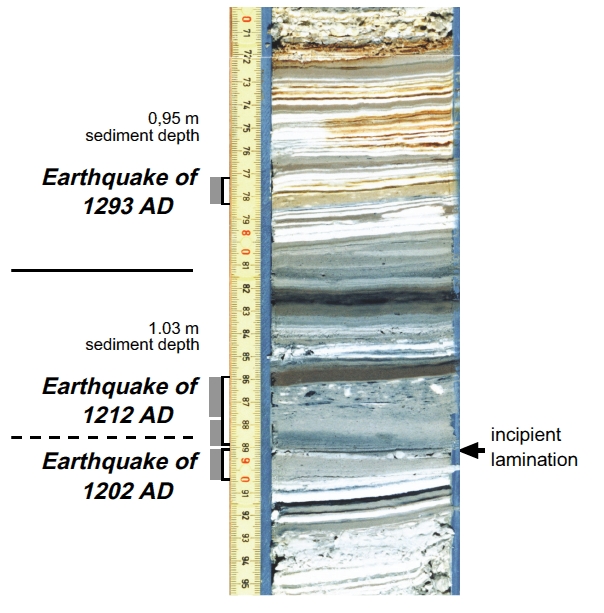
| Gulf of Aqaba | possible | n/a | n/a | Turbidites in R/V Thuwal Cores 17 and 18 in the northern part of the Gulf - ~1200-~1300 CE (1σ) Bektaş et al. (2024:13) report that turbidites were identified in R/V Thuwal cores 17 and 18 in the northern part of the Gulf of Aqaba where the turbidite in core 18 is thicker and better preserved with its laminated internal structure. Based on Probability Density Functions (PDFs) presented in Fig. 8 of their paper, the turbidites in cores 17 and 18 should have been deposited between ~1200 and ~1300 CE (1σ). Bektaş et al. (2024:13) suggested that the 1212 CE earthquake was responsible for these turbidites. Since only two cores recorded the event, Bektaş et al. (2024:13) concluded that the CE 1212 earthquake was likely significantly smaller than the CE 1068 and CE 1588 eventswhile noting that the exact location of this event north of the gulf remains uncertain, but it might have caused a discontinuous rupture on fault segments of the Wadi Arabah Fault system. This reasoning was based on the probable presence of the 1212 CE earthquake as Event E2 in the Qatar Trench, its supposed absence in the Elat Sabhka Trenches, and its supposed absence in the imprecisely dated Shehoret, Roded, and Avrona Alluvial Fan Trenches. It should be noted however that Kanari et al. (2020) listed the 1212 CE earthquake and the 1068 CE earthquake(s) as a possible cause of a dewatering structure (aka liquefaction fluid escape structure) in Trench T1 of the Elat Sabhka Trenches and that [opinion by JW] while Events 7, 8, and 9 in Trench T-18 in the Shehoret, Roded, and Avrona Alluvial Fan Trenches have a wide spread of ages, taken together, the evidence suggests that the 1212 CE earthquake, the 1068 CE earthquake(s), and one earlier earthquake, perhaps between ~500 CE and 1000 CE, struck the area. Bektaş et al. (2024:13) characterizes the Shehoret, Roded, and Avrona Alluvial Fan Trenches and Elat Sabhka Trenches researchers (Zilberman et al., 2005 and Kanari et al., 2020 respectively) as claiming that the CE 1212 earthquake was likely generated by a secondary fault on the eastern edge of the Eilat depression, rather than by the Wadi Arabah Fault. Bektaş et al. (2024:13) also noted that there are no turbidites in cores 14 and 15 around [the] 1200sand that a turbidite from the 1200s may be present in core 13. Event B in R/V Mediterranean Explorer core P27 - ~1293 CE 7 cm. thick Mass Transport Deposit Event B was identified in R/V Mediterranean Explorer Canyon Core P27 by Kanari et al (2015) and Ash-Mor et al. (2017). Ash-Mor et al. (2017) provided an unmodeled 14C date of ~1292 CE (658 ± 34 cal years BP) for the sediments below the mass transport deposit which Kanari et al (2015) associated with the 1458 CE earthquake although other events might also fit this approximate unmodeled date - e.g. the 1068 CE Earthquake, 1212 CE Earthquake, and the 1588 CE Earthquakes. Kanari et al (2015) based their date assignment of 1458 CE at least partly on their work in the nearby Elat Sabhka Trenches where Kanari et al. (2020) dated Event E2 in Trench T3 to after 1294 CE and listed earthquakes of 1458 CE and 1588 CE as likely candidates. Kanari et al. (2020) also identified liquefaction sand blows SB1 and SB2 in the same Elat Sabhka Trench (T3) which they dated to between 1287 and 1635 CE or 1287-1550 CE1. Kanari et al. (2020) surmised that the data for liquefaction sand blows SB1 and SB2 tend to support an interpretation of 1458 CE, but are inconclusive. |
|
| Location (with hotlink) | Status | Minimum PGA (g) | Likely PGA (g) | Likely Intensity1 | Comments |
| Location (with hotlink) | Status | Intensity | Notes | ||||||||||||||||||||||||||||
|---|---|---|---|---|---|---|---|---|---|---|---|---|---|---|---|---|---|---|---|---|---|---|---|---|---|---|---|---|---|---|---|
| Jordan Valley - Tell Saidiyeh and Ghor Kabed Trenches | possible | ≥ 7 | Ferry et al (2011) detected 12 surface rupturing seismic events in 4 trenches (T1-T4) in Tell Saidiyeh and Ghor Kabed; 10 of which were prehistoric. The tightest chronology came from the Ghor Kabed trenches (T1 and T2) where Events Y and Z were constrained to between 560 and 1800 CE. | ||||||||||||||||||||||||||||
| Dead Sea - Seismite Types | n/a | n/a | n/a | ||||||||||||||||||||||||||||
| Dead Sea - En Feshka | possible to probable | 8.1 - 8.9 (12 cm.) 8.0 - 8.8 (28 cm.) 8.1 - 8.9 (40 cm.) |
Kagan et. al. (2011)
identified several seismites from around this time.
|
||||||||||||||||||||||||||||
| Dead Sea - En Gedi | possible to probable | 8.1 - 8.9 |
|
||||||||||||||||||||||||||||
| Dead Sea - Nahal Ze 'elim | possible | 8.2 -9.0 | At site ZA-1, Ken-Tor et al (2001a) assigned a a date of 1212 CE to a ~10 cm. thick Type 4 seismite which they labeled as Event E and was dated between 1220 and 1390 CE (± 2σ). In Table 4 of Kagan et. al. (2011), a 10.5 cm. thick seismite at ZA-1 was associated with the 1212 CE earthquake. At site ZA-2, Kagan et. al. (2011) did not find any seismites whose time window encompassed 1212 CE. | ||||||||||||||||||||||||||||
| Araba - Introduction | n/a | n/a | n/a | ||||||||||||||||||||||||||||
| Araba - Qasr Tilah | unlikley to possible | ≥ 7 | Haynes et al. (2006) dated Events II and III to between the 7th and 12th centuries CE. | ||||||||||||||||||||||||||||
| Araba - Taybeh Trench | unlikely | LeFevre et al. (2018) did not assign any seismic events to an earthquake in 1212 CE. | |||||||||||||||||||||||||||||
| Araba - Qatar Trench | probable | ≥ 7 | Klinger et. al. (2015) identified one seismic event which fits.
|
||||||||||||||||||||||||||||
| Araba - Taba Sabhka Trench | possible | ≥ 7 | Allison (2013) assigned a 1068 CE date to a seismic event which they dated to between 1045 and 1661 CE and Allison (2013) assigned a 1212 CE date to a seismic event which they dated to between the mid 11th century CE and the 16-17th centuries CE. | ||||||||||||||||||||||||||||
| Araba - Shehoret, Roded, and Avrona Alluvial Fan Trenches | possible to probable | ≥ 7 | Events 7, 8, and 9 in Trench T-18 have a wide spread of ages however, taken together, the evidence suggests the 1212 CE, 1068 CE, and one earlier earthquake, perhaps between ~500 CE and 1000 CE, struck the area. Zilberman et al (2005) also discovered an early Islamic ranch in the western part of Avrona playa. The ranch was dated to the 11th century CE and was abandoned during the same century - an abandonment which Zilberman et al (2005) attributed to the effects of the 1068 CE earthquake. They measured 1 m of displacement of a Qanat (a covered water canal) on the ranch which they also attributed to the 1068 CE earthquake although it is possible that the displacement was caused by an earthquake which struck the area in 1212 CE. | ||||||||||||||||||||||||||||
| Araba - Elat Sabhka Trenches | possible | Kanari et al (2020) suggested that a dewatering structure (aka a liquefaction fluid escape structure) found in Trench T1 and dated to before 1269-1389 CE was caused by the 1068 CE Quake(s) or the 1212 CE Quake. | |||||||||||||||||||||||||||||
| Araba - Trenches in Aqaba | possible | ≥ 7 |
Niemi (2011:153) noted that the most recent scarp-forming event fault [in Trench AQ-1] occurred after A.D. 1045-1278 based on a corrected, calibrated radiocarbon age from charcoal collected from a buried campfire at the base of the scarp in Trench T-1. This likely represents fault motion in one of the historical earthquakes affecting southern Jordan (e.g. 1068, 1212, 1458, or 1588). |
||||||||||||||||||||||||||||
| Location (with hotlink) | Status | Intensity | Notes |
Figure 10

Fig. 2.12 1212 May 1, Dead Sea. (Ambraseys et al, 1994)
1212 May 1 27 Dhu'l-Qa'da 608 Dead Sea
A damaging earthquake in south Palestine also affected
Egypt, where it was strongly felt in Cairo and Fustat
and destroyed a number of houses. At al-Shaubak and
al-Karak, towers and houses were destroyed, killing a
number of women and children.1 The earliest account
says it was strongest in the part of Aila (Eilat) that is by
the sea.2
In the Sinai Peninsula, the shock caused severe damage to the monastery of St Catherine, destroying a major
part of its fortifications and damaging the church. The
northern wall of the monastery, with its northwest and
northeast corners, collapsed. Of the cells, some were
destroyed completely and others lost their roofs, apparently without loss of life. This was possibly due to the
fact that the earthquake, which struck at dawn, was preceded by a foreshock at sunset the previous evening
(Monday 30 April), which might have served as a warning. The shock triggered rockfalls from the mountains
behind the monastery, and was followed by aftershocks
that continued for a year. The date of the earthquake
was commemorated as a day for prayers and penitence.3
The walls and cells were almost immediately rebuilt
with the assistance of the metropolitan, Gabriel of
Supaki (Petra), whose caravan of builders originally sent
to rebuild the church at Agia Koryphi (Jabal Musa),
damaged by a previous shock, arrived at St Catherine's
six days after the earthquake.4
The earthquake is also said to have caused serious damage at Qalat al-Jundi
in Sinai,5 but the evidence is inconclusive.
The location of the earthquake should be sought in
the Gulf of Aqaba or south of the Dead Sea. No details
of the shock are recorded for Syria or Damascus (Figure
2.12).