Al-Marqab Citadel
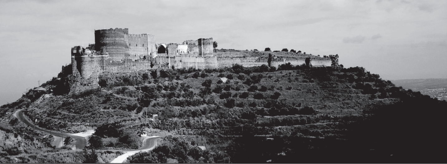 Figure 2
Al-Marqab citadel, as seen by attacking enemy from the south, was mostly built by the crusading Order of St. John (Hospitallers) in the late twelfth century. The hilltop plateau, 350 m above sea level, is vesicular basalt lava of Pliocene age, exposed below the highest towers. Terraces of olive gardens carved in weathered basaltic strata cover the slopes. Banyas city and the Mediterranean Sea are seen in the background on the right
Kázmér and Major (2010)
| Transliterated Name | Source | Name |
|---|---|---|
| Qalat Al-Marqab | Arabic | قلعة المرقب |
| Al-Marqab | Arabic | قلعة ا |
| Margat | Latin |
- Fig. 1 - Location Map
from Kázmér and Major (2010)
 Figure 1
Location of Al-Marqab (Margat) citadel in coastal Syria. Major historical earthquakes are centered along left-lateral strike-slip faults ranging from the Dead Sea fault in the south to the East Anatolian fault in the north (modified after Sbeinati et al., 2005). Epicenter of the A.D. 1202 earthquake, extensively discussed in the text, is underlined. Epicenters of the events of 1212, 1222, and 1303 earthquakes are out of the map in Jordan, Cyprus, and Crete, respectively.
- DSF — Dead Sea fault system
- YF — Yammouneh fault
- EAF — East Anatolian fault system
- EFS — Euphrates fault system
Epicenter locations are from Ambraseys (2009, electronic supplement). See also Table 1.
Kázmér and Major (2010) - Al-Marqab Citadel in Google Earth
 Al-Marqab Citadel in Google Earth
click on image to explore this site on a new tab in Google Earth
- Fig. 3 - Plan of the southern portion
of Al-Marqab citadel from Kázmér and Major (2010)
 Figure 3
Plan of the southern portion of Al-Marqab citadel. Heavy lines denote buildings with above ground walls. Light lines are circumferential walls and excavated foundations of buildings. Inset displays the location of the heavily fortified southern part and the much larger northern suburb, surrounded by weaker walls, totaling 5.7 ha together. The external double line is the modern asphalt road surrounding the hilltop.
Kázmér and Major (2010)
- Fig. 3 - Plan of the southern
portion of Al-Marqab citadel from Kázmér and Major (2010)
Figure 3
Plan of the southern portion of Al-Marqab citadel. Heavy lines denote buildings with above ground walls. Light lines are circumferential walls and excavated foundations of buildings. Inset displays the location of the heavily fortified southern part and the much larger northern suburb, surrounded by weaker walls, totaling 5.7 ha together. The external double line is the modern asphalt road surrounding the hilltop.
Kázmér and Major (2010)
- Fig. 12 Dedicatory Inscription from
A.H. 684 (9 March 1285 - 26 Feb. 1286 CE) - from Kázmér and Major (2010)
 Figure 12
Portion of an Arabic inscription on the southern tower bearing the name of Sultan Qalawun, who conquered Al-Marqab in A.D. 1285. The full text says “This well-guarded fortress has been conquered and this tower rebuilt by Sultan Qalawun in months of the year [H.] 684. This work was executed under the direction of Balaban al-Mansuri,” as read and published by Max van Berchem in his Voyage en Syrie, on p. 303 in the early twentieth century (fi de Deschamps, 1973, p. 273).
Kázmér and Major (2010)
The first archaeological excavation in Al-Marqab started in 2007; therefore, a large proportion of the castle fabric is still undated. However, a relative chronology (architectural stratigraphy as understood by Galadini et al., 2006) can be readily established for the buildings studied in this project. Muslim-built portions of the circumferential wall, especially the southernmost tower in the outer enceinte, are decorated with a frieze-like white row of ashlars within the black basalt wall. These blocks bear an Arabic inscription, testifying to its construction by the sultan Al-Mansur Qalawun (Mamluk sultan from 1279 to 1290), who took the castle in 1285 (Fig. 12).
The donjon is certainly a Hospitaller construction and thus dates from after the order acquired the castle in 1187. Besides architectural design and the sheer size of the building, which could hardly have been financed by a private lord, the first results of the geophysical surveys also seem to support this dating. A georadar survey carried out inside the castle chapel (unequivocally accepted to have been the first Hospitaller construction on the site) detected the contours of a rectangular structure. Its position and the thickness of its wall, exceeding 3 m, make it a likely candidate for being the residential tower of the Mazoir family. This assumption is further strengthened by the presence of an old cistern incorporated in the southern walls of the chapel that stands in the center of the conjectured Mazoir tower. The presence of rock-cut cisterns under the main towers of eminent Crusader castles in the twelfth century is very common. Because the defense of the southern part of the castle mountain requires the presence of a dominant building, the substitution of the Mazoir square tower by the chapel must have been closely followed by the building of the new donjon, which is likely to have taken place in the 1190s.
The supposed construction date of the donjon soon after 1187 and the precise dating of the southern corner tower after the successful Muslim siege of 1285 put constraints on dating the earthquake damages.
| Effect | Location | Image (s) | Comments |
|---|---|---|---|
| V-Shaped Failure/Extension | SW sector of the donjon wall
Figure 3 Plan of the southern portion of Al-Marqab citadel. Heavy lines denote buildings with above ground walls. Light lines are circumferential walls and excavated foundations of buildings. Inset displays the location of the heavily fortified southern part and the much larger northern suburb, surrounded by weaker walls, totaling 5.7 ha together. The external double line is the modern asphalt road surrounding the hilltop. Kázmér and Major (2010) |
 Figure 5
Left: A wedge-shaped block of donjon masonry wall moved toward 240° azimuth by ~20 cm. Right: Dashed line on archaeological plan of the top of donjon indicates estimated shape of displaced wedge. Gray arrow denotes direction of displacement. Kázmér and Major (2010) 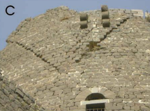 Figure 4c
V-shaped extension of the SW sector of the donjon wall, caused by earthquake. Separation is 5–20 cm Kázmér (2008) |
|
| Symmetrical Corner Collapse | A. NE corner of room M3 B. SW corner of room M3  Figure 8
Plan of room M3. Outline of symmetrical failures is indicated by dotted lines. Letters A and B correspond to failures shown on Figure 7. Arrows indicate 50°–240° extension direction, similar to the azimuth of the V-shaped failure of the donjon. Kázmér and Major (2010)
Figure 3Plan of the southern portion of Al-Marqab citadel. Heavy lines denote buildings with above ground walls. Light lines are circumferential walls and excavated foundations of buildings. Inset displays the location of the heavily fortified southern part and the much larger northern suburb, surrounded by weaker walls, totaling 5.7 ha together. The external double line is the modern asphalt road surrounding the hilltop. Kázmér and Major (2010) |
 Figure 7
Room M3, as seen from inside, bearing symmetrically arranged damages to opposite corners due to a NE-SW–oriented vibration.
Kázmér and Major (2010) |
Room M3 sits on top of the vault of the kitchen. It is the sole remnant of a previous, larger cluster of rooms, which might have served as an independent kitchen. Walls that are 66 to 104 cm wide bear a barrel vault. Diagonally opposite corners have suffered symmetrical damages (Figs. 7–8). Fractures that are concave outward have developed. The NE corner collapsed in full, destroying a segment of the vault and portions of the adjacent wall (Fig. 7A). The concave fault developed in the SW corner as well, but only part of the vault collapsed: there is a 2 × 1 m hole in the top of the vault, connected by an arcuate fracture — a would be failure scar — to the still-intact adjacent walls (Fig. 7B).- Kázmér and Major (2010) |
| Effect | Location | Image (s) | Comments |
|---|---|---|---|
| U Shaped Gap | Top of Mamluk tower
Figure 3 Plan of the southern portion of Al-Marqab citadel. Heavy lines denote buildings with above ground walls. Light lines are circumferential walls and excavated foundations of buildings. Inset displays the location of the heavily fortified southern part and the much larger northern suburb, surrounded by weaker walls, totaling 5.7 ha together. The external double line is the modern asphalt road surrounding the hilltop. Kázmér and Major (2010) |
 Figure 9
Symmetrical, scoop-like damage affecting top of Mamluk tower facing toward 130°SE. Both upper, thin (140 cm) and lower, thick (>3 m) portions of wall collapsed toward SE (arrow). Two box machicolations are visible on top left. Kázmér and Major (2010) |
The top of the southern corner tower of the outer enceinte, the outer ring of walls of the Mamluk-built structure, bears a downward-concave failure. Both thin and thick portions of the tower have failed (Fig. 9).- Kázmér and Major (2010) |
| Effect | Location | Image (s) | Comments |
|---|---|---|---|
| V-Shaped Failure | Donjon masonry wall
Figure 3 Plan of the southern portion of Al-Marqab citadel. Heavy lines denote buildings with above ground walls. Light lines are circumferential walls and excavated foundations of buildings. Inset displays the location of the heavily fortified southern part and the much larger northern suburb, surrounded by weaker walls, totaling 5.7 ha together. The external double line is the modern asphalt road surrounding the hilltop. Kázmér and Major (2010) |
Figure 5 Left: A wedge-shaped block of donjon masonry wall moved toward 240° azimuth by ~20 cm. Right: Dashed line on archaeological plan of the top of donjon indicates estimated shape of displaced wedge. Gray arrow denotes direction of displacement. Kázmér and Major (2010) |
There is a spectacular V-shaped extrusion on thedonjon, the main tower of the citadel of 5 m height and 5 m width (Fig. 5). Similar features occur elsewhere in the castle. It seems that if failure were to progress, we would see a wedge-shaped block missing from the wall of the donjon.- Kázmér and Major (2010) |
| Single Corner Collapse | NW corner of the donjon
Figure 3 Plan of the southern portion of Al-Marqab citadel. Heavy lines denote buildings with above ground walls. Light lines are circumferential walls and excavated foundations of buildings. Inset displays the location of the heavily fortified southern part and the much larger northern suburb, surrounded by weaker walls, totaling 5.7 ha together. The external double line is the modern asphalt road surrounding the hilltop. Kázmér and Major (2010) |
 Figure 6
Failed corner of perpendicular walls at NW corner of the donjon. Approximated by a normal fault dipping ~50° to 284°NW direction. Failure is ~3 m wide at horizontal line Kázmér and Major (2010) |
Adjoining, possible perpendicular walls have collapsed at their joining. Collapse occurs where both walls are free-standing, i.e., unconfined at least to one side. This partial collapse produces an uneven oblique surface, cutting both walls at an angle (Fig. 6). Although of irregular shape, the pattern of collapse is comparable to a failure plane that can be interpreted as a normal fault. The smoothed surface of the failure is considered the fault plane, where the two directions necessary for geological characterization, strike and dip, can be measured and/or calculated. Because we do not have any evidence for the displacement direction of the hanging wall (fallen fragments have been cleared centuries ago), we assume dip slip.- Kázmér and Major (2010) |
| Symmetrical Corner Collapse | A. NE corner of room M3 B. SW corner of room M3
Figure 8Plan of room M3. Outline of symmetrical failures is indicated by dotted lines. Letters A and B correspond to failures shown on Figure 7. Arrows indicate 50°–240° extension direction, similar to the azimuth of the V-shaped failure of the donjon. Kázmér and Major (2010)
Figure 3Plan of the southern portion of Al-Marqab citadel. Heavy lines denote buildings with above ground walls. Light lines are circumferential walls and excavated foundations of buildings. Inset displays the location of the heavily fortified southern part and the much larger northern suburb, surrounded by weaker walls, totaling 5.7 ha together. The external double line is the modern asphalt road surrounding the hilltop. Kázmér and Major (2010) |
Figure 7 Room M3, as seen from inside, bearing symmetrically arranged damages to opposite corners due to a NE-SW–oriented vibration.
Kázmér and Major (2010) |
Room M3 sits on top of the vault of the kitchen. It is the sole remnant of a previous, larger cluster of rooms, which might have served as an independent kitchen. Walls that are 66 to 104 cm wide bear a barrel vault. Diagonally opposite corners have suffered symmetrical damages (Figs. 7–8). Fractures that are concave outward have developed. The NE corner collapsed in full, destroying a segment of the vault and portions of the adjacent wall (Fig. 7A). The concave fault developed in the SW corner as well, but only part of the vault collapsed: there is a 2 × 1 m hole in the top of the vault, connected by an arcuate fracture — a would be failure scar — to the still-intact adjacent walls (Fig. 7B).- Kázmér and Major (2010) |
| U-Shaped Gap | Top of Mamluk tower
Figure 3 Plan of the southern portion of Al-Marqab citadel. Heavy lines denote buildings with above ground walls. Light lines are circumferential walls and excavated foundations of buildings. Inset displays the location of the heavily fortified southern part and the much larger northern suburb, surrounded by weaker walls, totaling 5.7 ha together. The external double line is the modern asphalt road surrounding the hilltop. Kázmér and Major (2010) |
Figure 9 Symmetrical, scoop-like damage affecting top of Mamluk tower facing toward 130°SE. Both upper, thin (140 cm) and lower, thick (>3 m) portions of wall collapsed toward SE (arrow). Two box machicolations are visible on top left. Kázmér and Major (2010) |
The top of the southern corner tower of the outer enceinte, the outer ring of walls of the Mamluk-built structure, bears a downward-concave failure. Both thin and thick portions of the tower have failed (Fig. 9).- Kázmér and Major (2010) |
| Dislodged Building Blocks | Mamluk tower
Figure 3 Plan of the southern portion of Al-Marqab citadel. Heavy lines denote buildings with above ground walls. Light lines are circumferential walls and excavated foundations of buildings. Inset displays the location of the heavily fortified southern part and the much larger northern suburb, surrounded by weaker walls, totaling 5.7 ha together. The external double line is the modern asphalt road surrounding the hilltop. Kázmér and Major (2010) |

Kázmér and Major (2010) |
A large variety of shifted and rotated building blocks (ashlars) are seen at Al-Marqab. A shift within the plane of the wall is spectacularly shown in Figure 10. Heavily protected stone boxes extrude from the top of walls. Open bottoms allowed defenders to pour hot water, oil, or burning tar on attackers climbing the walls.- Kázmér and Major (2010) |
| Subsoil | Donjon and later addition
Figure 3 Plan of the southern portion of Al-Marqab citadel. Heavy lines denote buildings with above ground walls. Light lines are circumferential walls and excavated foundations of buildings. Inset displays the location of the heavily fortified southern part and the much larger northern suburb, surrounded by weaker walls, totaling 5.7 ha together. The external double line is the modern asphalt road surrounding the hilltop. Kázmér and Major (2010) |
 Figure 11
Crusader donjon (round tower partly hidden in background) and a later addition, Muslim southern tower built by Sultan Qalawun after his successful siege in 1285, bearing a row of white ashlars in the foreground. Both were firmly erected on several-meter-thick, unweathered vesicular basalt lava flow of Pliocene age (encircled), as seen on both sides of the glacis (inclined wall). Muslim tower is 20 m wide from corner to corner Kázmér and Major (2010) |
The buildings and walls of Al-Marqab have been erected on the solid subsoil of a several-meter-thick layer of compact Pliocene basalt (Fig. 11). This rock is not prone to liquefaction, even under major earthquakes, and neither is it affected by compaction under changing groundwater level (Ambraseys, 2006). The latter is ~50 m below the citadel, as shown by the location of the public bath on the western hillside- Kázmér and Major (2010) |
| Broken Stones - Broken top of a window | Donjon W side, adjacent to hall N3
Figure 3 Plan of the southern portion of Al-Marqab citadel. Heavy lines denote buildings with above ground walls. Light lines are circumferential walls and excavated foundations of buildings. Inset displays the location of the heavily fortified southern part and the much larger northern suburb, surrounded by weaker walls, totaling 5.7 ha together. The external double line is the modern asphalt road surrounding the hilltop. Kázmér and Major (2010) |
 Figure 3a
Broken top of a window. Donjon W side, adjacent to hall N3 Kázmér (2008) |
The bridging of practically all openings (windows, doors) is broken (Figure 3A). By definition, the break occurs in the middle of the long stone beams. The earthquake origin of the break has not been proven — the long stone beams, which are thin in relation to their length, are anyway sensitive to tension and break easily. After taking the dimensions (also modeling the weight on the beam), the earthquake origin could be confirmed or refuted by the basalt fracture test.- Kázmér (2008) |
| Slipped blocks in vaulted openings - Fallen ashlars in arch above gate | Western outer gate, SW tower
Figure 3 Plan of the southern portion of Al-Marqab citadel. Heavy lines denote buildings with above ground walls. Light lines are circumferential walls and excavated foundations of buildings. Inset displays the location of the heavily fortified southern part and the much larger northern suburb, surrounded by weaker walls, totaling 5.7 ha together. The external double line is the modern asphalt road surrounding the hilltop. Kázmér and Major (2010) |
 Figure 3b
Fallen ashlars in arch above gate. Western outer gate, SW tower. Kázmér (2008) |
Some of the stones carved into a wedge shape, but usually fitted together without a binder, tend to slide lower than the others. Displacements of this kind can only occur in arches carrying a relatively small load. If we observe similar phenomena in heavily loaded vaults, they could only have occurred after the load above them collapsed. In arches with a symmetrical load, the keystone slides down, in the case of an asymmetrical load, one of the side stones. It has been proven with both loading experiments and computer modeling that this kind of deformation can only occur in the case of strong earthquakes (Marco 2008: 149-150, with detailed literature references).- Kázmér (2008) |
| Horizontally dislodged blockstones - Shaken ashlars of machicolation | Qalaun tower, S side
Figure 3 Plan of the southern portion of Al-Marqab citadel. Heavy lines denote buildings with above ground walls. Light lines are circumferential walls and excavated foundations of buildings. Inset displays the location of the heavily fortified southern part and the much larger northern suburb, surrounded by weaker walls, totaling 5.7 ha together. The external double line is the modern asphalt road surrounding the hilltop. Kázmér and Major (2010) |
 Figure 3c
Shaken ashlars of machicolation. Qalaun tower, S side. Kázmér (2008) |
(Fig. 3C, D). This displacement is caused by the vertical component of the seismic waves. The rock block, or the load on it increases, so friction is reduced to a minimum and the block moves easily due to the horizontal components (Marco 2008: 150).- Kázmér (2008) |
| Horizontally dislodged blockstones - Shaken ashlars of machicolation | Southern bastion, W side
Figure 3 Plan of the southern portion of Al-Marqab citadel. Heavy lines denote buildings with above ground walls. Light lines are circumferential walls and excavated foundations of buildings. Inset displays the location of the heavily fortified southern part and the much larger northern suburb, surrounded by weaker walls, totaling 5.7 ha together. The external double line is the modern asphalt road surrounding the hilltop. Kázmér and Major (2010) |
 Figure 3d
Shifted ashlars of machicolation. Southern bastion, W side. Kázmér (2008) |
(Fig. 3C, D). This displacement is caused by the vertical component of the seismic waves. The rock block, or the load on it increases, so friction is reduced to a minimum and the block moves easily due to the horizontal components (Marco 2008: 150).- Kázmér (2008) |
| Clockwise rotated ashlars | Southern bastion, W side
Figure 3 Plan of the southern portion of Al-Marqab citadel. Heavy lines denote buildings with above ground walls. Light lines are circumferential walls and excavated foundations of buildings. Inset displays the location of the heavily fortified southern part and the much larger northern suburb, surrounded by weaker walls, totaling 5.7 ha together. The external double line is the modern asphalt road surrounding the hilltop. Kázmér and Major (2010) |
 Figure 3e
Clockwise rotated ashlars. Southern bastion, W side Kázmér (2008) |
(Fig. 3E, F). A special case of the previous deformation; translation and rotation often occur together. The rotation can be right (clockwise) or left (counter-clockwise) (Korjenkov & Mazor 1999, Fig. 20).- Kázmér (2008) |
| Clockwise rotated ashlars | Qalaun tower, S side
Figure 3 Plan of the southern portion of Al-Marqab citadel. Heavy lines denote buildings with above ground walls. Light lines are circumferential walls and excavated foundations of buildings. Inset displays the location of the heavily fortified southern part and the much larger northern suburb, surrounded by weaker walls, totaling 5.7 ha together. The external double line is the modern asphalt road surrounding the hilltop. Kázmér and Major (2010) |
 Figure 3f
Clockwise rotated ashlar. Qalaun tower, S side. Kázmér (2008) |
(Fig. 3E, F). A special case of the previous deformation; translation and rotation often occur together. The rotation can be right (clockwise) or left (counter-clockwise) (Korjenkov & Mazor 1999, Fig. 20).- Kázmér (2008) |
| V-shaped extension | SW sector of the donjon wall
Figure 3 Plan of the southern portion of Al-Marqab citadel. Heavy lines denote buildings with above ground walls. Light lines are circumferential walls and excavated foundations of buildings. Inset displays the location of the heavily fortified southern part and the much larger northern suburb, surrounded by weaker walls, totaling 5.7 ha together. The external double line is the modern asphalt road surrounding the hilltop. Kázmér and Major (2010) |
Figure 4c V-shaped extension of the SW sector of the donjon wall, caused by earthquake. Separation is 5–20 cm Kázmér (2008) |
in the upper part of the donjon (Fig. 4C). While the other fractures crossing the residential tower can be observed both on the outside and inside of the wall, this several-meter-long body is only visible from the outside. The bounding fractures thus meet inside the wall. It does not start down from the top of AV either, there is a break in the direction of the foundation, so this cannot be the result of uneven subsidence. Probably during an earthquake, a larger piece broke off from the upper, strongly swaying part of the tower and moved according to the direction of the vibration.- Kázmér (2008) |
| Arch Fractures | vault of the chapel along the western wall
Figure 3 Plan of the southern portion of Al-Marqab citadel. Heavy lines denote buildings with above ground walls. Light lines are circumferential walls and excavated foundations of buildings. Inset displays the location of the heavily fortified southern part and the much larger northern suburb, surrounded by weaker walls, totaling 5.7 ha together. The external double line is the modern asphalt road surrounding the hilltop. Kázmér and Major (2010) |
 Figure 4d
Fractures in the vault of the chapel along the western wall. Kázmér (2008) |
perpendicular to the longitudinal axis (Figure 4D). The depicted crack system appears in both fields of the two-bay vault of the castle chapel, along the connection with all four retaining walls. Therefore, it cannot be considered a reflection of a foundation problem, but rather the result of a force that affected all the walls.- Kázmér (2008) |
| Effect | Location | Image (s) | Comments |
|---|---|---|---|
| Structure of Masonry Wall | Windward wall of the donjon
Figure 3 Plan of the southern portion of Al-Marqab citadel. Heavy lines denote buildings with above ground walls. Light lines are circumferential walls and excavated foundations of buildings. Inset displays the location of the heavily fortified southern part and the much larger northern suburb, surrounded by weaker walls, totaling 5.7 ha together. The external double line is the modern asphalt road surrounding the hilltop. Kázmér and Major (2010) |
 Figure 4
Ashlars in the western, windward wall of the donjon are seemingly unsupported. However, their rear side is firmly embedded in Roman concrete, the cementing material of the several-meter-thick wall. Laid initially with mortar, westerly winds and rain have removed much of it throughout eight centuries. Arrow: measuring tape for scale, 20 cm long. Kázmér and Major (2010) |
Ashlars in the western, windward wall of the donjon are seemingly unsupported. However, their rear side is firmly embedded in Roman concrete, the cementing material of the several-meter-thick wall. Laid initially with mortar, westerly winds and rain have removed much of it throughout eight centuries.- Kázmér and Major (2010) |
| Structure of Masonry Wall | southern window of the chapel
Figure 3 Plan of the southern portion of Al-Marqab citadel. Heavy lines denote buildings with above ground walls. Light lines are circumferential walls and excavated foundations of buildings. Inset displays the location of the heavily fortified southern part and the much larger northern suburb, surrounded by weaker walls, totaling 5.7 ha together. The external double line is the modern asphalt road surrounding the hilltop. Kázmér and Major (2010) |
 Figure 4a
Three-leaf wall as exposed in the southern window of the chapel. An external regular ashlar work served during construction as a mould for casting the core. The core is agglomerate of stones and mortar Kázmér (2008) |
Three-leaf wall as exposed in the southern window of the chapel. An external regular ashlar work served during construction as a mould for casting the core. The core is agglomerate of stones and mortar- Kázmér (2008) |
| Structure of Masonry Wall | external wall of the donjon
Figure 3 Plan of the southern portion of Al-Marqab citadel. Heavy lines denote buildings with above ground walls. Light lines are circumferential walls and excavated foundations of buildings. Inset displays the location of the heavily fortified southern part and the much larger northern suburb, surrounded by weaker walls, totaling 5.7 ha together. The external double line is the modern asphalt road surrounding the hilltop. Kázmér and Major (2010) |
 Figure 4b
Basalt ashlars on the external wall of the donjon. This is only a mould supporting the agglomerate core during casting. Ashlars frequently are not joining each other, or are separated by thin flakes of basalt, unsuitable to bear the weight of the donjon. Rear side of ashlars is embedded in mortar of the core. Kázmér (2008) |
Basalt ashlars on the external wall of the donjon. This is only a mould supporting the agglomerate core during casting. Ashlars frequently are not joining each other, or are separated by thin flakes of basalt, unsuitable to bear the weight of the donjon. Rear side of ashlars is embedded in mortar of the core.- Kázmér (2008) |
- Modified by JW from Fig.s 3, 5, and 8 of Kázmér and Major (2010)
 Deformation Map
Modified by JW from Fig.s 3, 5, and 8 of Kázmér and Major (2010)
- Modified by JW from Fig.s 3 and 9 of Kázmér and Major (2010)
 Deformation Map
Modified by JW from Fig.s 3 and 9 of Kázmér and Major (2010)
- Subjective MMI Intensity
Scale

 Subjective MMI Intensity Scale
Click on image to open in a new tab
| Effect | Location | Image (s) | Comments | Intensity |
|---|---|---|---|---|
|
Fortress of Margat [Marqab] |
|
|
-
Earthquake Archeological Effects chart
of Rodríguez-Pascua et al (2013: 221-224)
 Earthquake Archeological Effects (EAE)
Rodríguez-Pascua et al (2013: 221-224)
| Effect | Location | Image (s) | Comments | Intensity |
|---|---|---|---|---|
| V-Shaped Failure/Extension - Displaced Masonry blocks | SW sector of the donjon wall
Figure 3 Plan of the southern portion of Al-Marqab citadel. Heavy lines denote buildings with above ground walls. Light lines are circumferential walls and excavated foundations of buildings. Inset displays the location of the heavily fortified southern part and the much larger northern suburb, surrounded by weaker walls, totaling 5.7 ha together. The external double line is the modern asphalt road surrounding the hilltop. Kázmér and Major (2010) |
Figure 5 Left: A wedge-shaped block of donjon masonry wall moved toward 240° azimuth by ~20 cm. Right: Dashed line on archaeological plan of the top of donjon indicates estimated shape of displaced wedge. Gray arrow denotes direction of displacement. Kázmér and Major (2010)
Figure 4cV-shaped extension of the SW sector of the donjon wall, caused by earthquake. Separation is 5–20 cm Kázmér (2008) |
|
VIII + |
| Symmetrical Corner Collapse - Wall Collapse | A. NE corner of room M3 B. SW corner of room M3
Figure 8Plan of room M3. Outline of symmetrical failures is indicated by dotted lines. Letters A and B correspond to failures shown on Figure 7. Arrows indicate 50°–240° extension direction, similar to the azimuth of the V-shaped failure of the donjon. Kázmér and Major (2010)
Figure 3Plan of the southern portion of Al-Marqab citadel. Heavy lines denote buildings with above ground walls. Light lines are circumferential walls and excavated foundations of buildings. Inset displays the location of the heavily fortified southern part and the much larger northern suburb, surrounded by weaker walls, totaling 5.7 ha together. The external double line is the modern asphalt road surrounding the hilltop. Kázmér and Major (2010) |
Figure 7 Room M3, as seen from inside, bearing symmetrically arranged damages to opposite corners due to a NE-SW–oriented vibration.
Kázmér and Major (2010) |
Room M3 sits on top of the vault of the kitchen. It is the sole remnant of a previous, larger cluster of rooms, which might have served as an independent kitchen. Walls that are 66 to 104 cm wide bear a barrel vault. Diagonally opposite corners have suffered symmetrical damages (Figs. 7–8). Fractures that are concave outward have developed. The NE corner collapsed in full, destroying a segment of the vault and portions of the adjacent wall (Fig. 7A). The concave fault developed in the SW corner as well, but only part of the vault collapsed: there is a 2 × 1 m hole in the top of the vault, connected by an arcuate fracture — a would be failure scar — to the still-intact adjacent walls (Fig. 7B).- Kázmér and Major (2010) |
VIII + |
-
Earthquake Archeological Effects chart
of Rodríguez-Pascua et al (2013: 221-224)
Earthquake Archeological Effects (EAE)
Rodríguez-Pascua et al (2013: 221-224)
| Effect | Location | Image (s) | Comments | Intensity |
|---|---|---|---|---|
| U Shaped Gap - Collapsed Walls | Top of Mamluk tower
Figure 3 Plan of the southern portion of Al-Marqab citadel. Heavy lines denote buildings with above ground walls. Light lines are circumferential walls and excavated foundations of buildings. Inset displays the location of the heavily fortified southern part and the much larger northern suburb, surrounded by weaker walls, totaling 5.7 ha together. The external double line is the modern asphalt road surrounding the hilltop. Kázmér and Major (2010) |
Figure 9 Symmetrical, scoop-like damage affecting top of Mamluk tower facing toward 130°SE. Both upper, thin (140 cm) and lower, thick (>3 m) portions of wall collapsed toward SE (arrow). Two box machicolations are visible on top left. Kázmér and Major (2010) |
The top of the southern corner tower of the outer enceinte, the outer ring of walls of the Mamluk-built structure, bears a downward-concave failure. Both thin and thick portions of the tower have failed (Fig. 9).- Kázmér and Major (2010) |
VIII+ |
 Table 1
HISTORICAL EARTHQUAKES REPORTED OR SUSPECTED TO HAVE AFFECTED AL-MARQAB CITADEL (MODIFIED AFTER AMBRASEYS, 2009)
Kázmér and Major (2010)
 Figure 13
Dating of major earthquake damages in the history of AlMarqab citadel. Known earthquakes are listed after Sbeinati et al. (2005); most damaging seismic events are underlined. Double arrows refer to vibration directions as calculated from orientation of failures. These display an earlier, 60°–240° direction as shown by V-shaped extrusion of the donjon and symmetrical extensional failure of room M3 (Figs. 7–8). This is probably due to the 20 May 1202 earthquake. The later, 310°–130°-directed vibration is seen on the southern tower, built during the Muslim period (Fig. 9). It occurred any time after 1285 and may be correlated to the 1404 (and/or 1408?) earthquake.
Kázmér and Major (2010)