Chastel Blanc
 Figure 2
Photo of Chastel Blanc taken ca. 1935 by Pierre Antoine Berrurier
wikipedia (public domain)
| Transliterated Name | Source | Name |
|---|---|---|
| Chastel Blanc | French | |
| Castrum Album | Latin | |
| Burj Safita | Arabic | برج صافيتا |
| Safita Castle | ||
| Safita Tower |
- Fig. 1 - Location Map from
Kázmér and Major (2015)
 Figure 1
Location of studied sites in coastal Syria. Major historical earthquakes are centred along left-lateral strike-slip faults ranging from the Dead Sea Fault in the south to the East Anatolian Fault in the north (after Sbeinati et al., 2005, modified). The epicentre of the 1202 earthquake is underlined. The epicentres of the events of 1212, 1222, and 1303 are out of the map in Jordan, Cyprus, and Crete, respectively.
- Q1: Khirbat al-Qurshiya
- Q2: ‘Ayn-Qadı¯b
- DSF: Dead Sea Fault system
- YF: Yammouneh Fault
- EAF: East Anatolian Fault system
- EFS: Euphrates Fault system
Epicentre locations are from Ambraseys (2009, electronic supplement).
Kázmér and Major (2015) - Fig. 6 Map of direction of
deformation and displacement from Kázmér and Major (2015)
 Figure 6
Direction of deformation and displacement. Segments of the Levant Fault system after Meghraoui et al. (2003) and Daeron et al. (2007). Paired arrows indicate strong motion directions: north–south deformation in Safıta, and northwards displacement al-Qurshiyya and ‘Ayn-Qadıb. Safıta is 19 km from the Levant Fault. Khirbat al-Qurshiyya and ‘Ayn-Qadıb are both less than 6 km from the Missyaf segment. Al-Marqab citadel bears damages oriented towards 240˚ caused by the AD 1202 earthquake and towards 130˚ caused by an earthquake after 1275 (Kazmer and Major, 2010).
- B: Beirut
- D: Damascus
- L: Lattakia
- T: Tartus
Kázmér and Major (2015)
- Chastel Blanc in Google Earth
 Chastel Blanc
click on image to explore this site on a new tab in Google Earth - Ayn Qadib in Google Earth
 Ayn Qadib
click on image to explore this site on a new tab in Google Earth - Khirbat al-Qurshiya vicinity in Google Earth
 Khirbat al-Qurshiya vicinity
click on image to explore this site on a new tab in Google Earth
- Fig. 3 Plan of the donjon
with locations of photos and indicated deformation from Kázmér and Major (2015)
 Figure 3
Deformation of the donjon. There are four strike-slip shear zones dissecting the donjon across both the western and eastern window bays of the knights’ hall. Heavy red lines: Kazmer and Major (2014): Safita castle 35 illustrate that the central portion of the northern wall moved about 20 cm to the north, while the central portion of the southern wall moved ca. 30 cm to the south. The resulting deformation is a north–south extension of the upper floor of the donjon. Scale in metres. Arrows refer to the photos in Fig. 2.
Kázmér and Major (2015)
- Fig. 2a Photo of the donjon
from Kázmér and Major (2015)
 Figure 2a
view from west. Note the window-less walls. The only entrance to the tower is a small door on the western wall
Kázmér and Major (2015)
| Location | Photo(s) | Comments | Reference |
|---|---|---|---|
| Khirbat al-Qurshiyya | Fig. 4
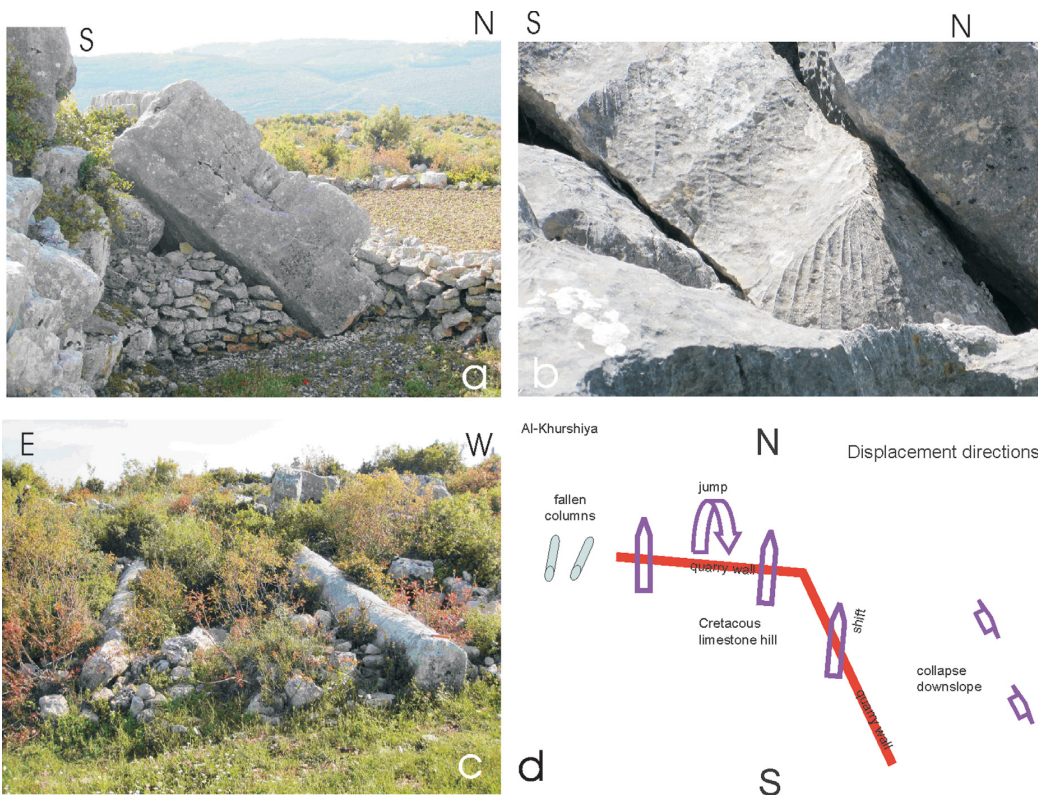 Figure 4
Damages and directivity of strong motion in Khirbat al-Qurshiya:
Kázmér and Major (2015) |
Damages and directivity of strong motion in Khirbat al-Qurshiya | Kázmér and Major (2015) |
| Khirbat al-Qurshiyya | Table 1
 Table 1
Karren dimensions on fallen blocks in Khirbat al-Qurshiya. The age is based on a 18-mm/year average dissolution rate (after Furlani et al., 2009), and has to be understood as a rude approximation only Kázmér and Major (2015) |
Date estimates of Rockfalls at Khirbat al-Qurshiya based on Karren dissolution features | Kázmér and Major (2015) |
| Coastal Syria | Table 2
 Table 2
Climate parameters of the Karst Mountains in the northeastern Adriatic region and in coastal Syria (after Furlani et al., 2009 and Wirth, 1971). Kázmér and Major (2015) |
Climate parameters of the Karst Mountains in the northeastern Adriatic region and in coastal Syria | Kázmér and Major (2015) |
The rockfalls at these sites were presumed to have a seismic origin due to their inherent aseismic stability ( Kázmér and Major, 2015:186-187). Dating of the rockfalls was estimated by examining rainwater induced chemical dissolution of an overprint of a younger karren rill system (Fig. 4b below) up to 37 mm. wide and up to 9 mm. deep (Table 1 below). Kázmér and Major (2015:188) discussed dissolution rates and approximate dates as follows:
Rate of karren formation (karst dissolution) on inland surfaces is about 10–13 µm/year (ranging from 9 to 38 µm/year) on sparitic limestone, up to 38 µm/year on micritic limestone. The mean value is 18 µm/year (Furlani et al., 2009). These values apply to the Karst mountains along the coast of the northeastern Adriatic Sea. The higher elevations in the Jabal Ansariyya, where Khirbat al- Qurshiyya is located, have a wet, oceanic climate (Mediterranean climate) (Wirth, 1971), very similar to that of the Karst in the Dinaric Mountains, where the longest series of detailed surface lowering measurements are available (Table 2 below) (Furlani et al., 2009). The average age of the rockfall, based on the minimum 8 µm/year dissolution rate, is 763 years, i.e. the middle of the 13th century; based on the maximum 22 µm/year dissolution rate, it is 277 years, i.e. the middle of the 18th century; based on the average 18 µm/year rate, it is 339 years, i.e. the late 17th century. The error margin is high. The measurements used for comparison were made in the modern Mediterranean in Karst, while we compare them to surfaces developed during the Late Medieval climate optimum and/or the early Little Ice Age in the Jabal Ansariyya. Therefore none of the data listed above can be interpreted as real age. We can be sure only that the earthquake that destroyed Khirbat al-Qurshiyya occurred during the last millennium.
| Effect | Location | Photo(s) | Comments |
|---|---|---|---|
| Extruded Walls and Displaced Walls | Fig.s 2a and 2b - crusader donjon of Safita/Chastel Blanc
Figure 3 Deformation of the donjon. There are four strike-slip shear zones dissecting the donjon across both the western and eastern window bays of the knights’ hall. Heavy red lines: Kazmer and Major (2014): Safita castle 35 illustrate that the central portion of the northern wall moved about 20 cm to the north, while the central portion of the southern wall moved ca. 30 cm to the south. The resulting deformation is a north–south extension of the upper floor of the donjon. Scale in metres. Arrows refer to the photos in Fig. 2. Kázmér and Major (2015) |
Fig. 2b
 Figure 2b
detail of the southern facade. Right-lateral displacement of ashlars near the top of the donjon diminishes downwards Kázmér and Major (2015) Fig. 2c  Figure 2c
the ground floor hall is a church, now in use by the local Maronite Christian community. Note the shifted ashlars seen above the illuminated cross in the axis of the hemispherical dome of the apse Kázmér and Major (2015) |
|
| Displaced Wall | northern facade of the crusader donjon of Safita/Chastel Blanc
Figure 3 Deformation of the donjon. There are four strike-slip shear zones dissecting the donjon across both the western and eastern window bays of the knights’ hall. Heavy red lines: Kazmer and Major (2014): Safita castle 35 illustrate that the central portion of the northern wall moved about 20 cm to the north, while the central portion of the southern wall moved ca. 30 cm to the south. The resulting deformation is a north–south extension of the upper floor of the donjon. Scale in metres. Arrows refer to the photos in Fig. 2. Kázmér and Major (2015) |
Extremely thick, 2.5-m wall, broken and displaced- Kázmér and Major (2015) |
|
| Dropped keystones | Fig.s 2e and 2f - crusader donjon of Safita/Chastel Blanc
Figure 3 Deformation of the donjon. There are four strike-slip shear zones dissecting the donjon across both the western and eastern window bays of the knights’ hall. Heavy red lines: Kazmer and Major (2014): Safita castle 35 illustrate that the central portion of the northern wall moved about 20 cm to the north, while the central portion of the southern wall moved ca. 30 cm to the south. The resulting deformation is a north–south extension of the upper floor of the donjon. Scale in metres. Arrows refer to the photos in Fig. 2. Kázmér and Major (2015) |
Fig. 2e
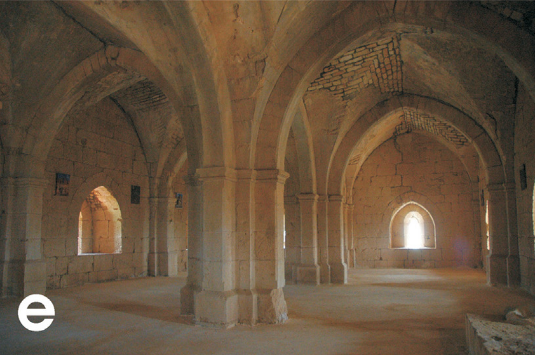 Figure 2e
: the first floor hall (above the ground floor church) was probably the common dormitory of the Knights Hospitaller [JW: I think he meant Knights Templar]. Two central pillars bear Gothic arches hold the weight of the roof. Heavy repairs in the vault of the right-side aisle are witnesses to shifted and/or broken ashlars there Kázmér and Major (2015) Fig. 2f  Figure 2f
dropped keystone in a north–south oriented Gothic arch of the first floor hall Kázmér and Major (2015) |
The highest points of the arches separating the groin vaults in the upper floor hall are invariably badly damaged (Fig. 2e). Keystones and adjacent ashlars have been broken and/or subsided by several centimetres (Fig. 2f). Finite-element modelling proved that only major earthquakes are capable of producing downward sliding of keystones (Kamai and Hatzor, 2008).- Kázmér and Major (2015) |
| Shifted blocks | random locations in the crusader donjon of Safita/Chastel Blanc
Figure 3 Deformation of the donjon. There are four strike-slip shear zones dissecting the donjon across both the western and eastern window bays of the knights’ hall. Heavy red lines: Kazmer and Major (2014): Safita castle 35 illustrate that the central portion of the northern wall moved about 20 cm to the north, while the central portion of the southern wall moved ca. 30 cm to the south. The resulting deformation is a north–south extension of the upper floor of the donjon. Scale in metres. Arrows refer to the photos in Fig. 2. Kázmér and Major (2015) |
There are wide gaps, up to a few centimetres, between blocks, distributed seemingly at random. These are the ‘displaced masonry blocks’ of Rodrıguez-Pascua et al. (2011).- Kázmér and Major (2015) |
|
| Left-lateral displacement of the northern wall | Fig. 2d - crusader donjon of Safita/Chastel Blanc
Figure 3 Deformation of the donjon. There are four strike-slip shear zones dissecting the donjon across both the western and eastern window bays of the knights’ hall. Heavy red lines: Kazmer and Major (2014): Safita castle 35 illustrate that the central portion of the northern wall moved about 20 cm to the north, while the central portion of the southern wall moved ca. 30 cm to the south. The resulting deformation is a north–south extension of the upper floor of the donjon. Scale in metres. Arrows refer to the photos in Fig. 2. Kázmér and Major (2015) |
Fig. 2d
 Figure 2d
first floor: left-lateral displacement of the northern wall Kázmér and Major (2015) |
|
| Rotated masonry blocks in walls | western facade of the crusader donjon of Safita/Chastel Blanc
Figure 3 Deformation of the donjon. There are four strike-slip shear zones dissecting the donjon across both the western and eastern window bays of the knights’ hall. Heavy red lines: Kazmer and Major (2014): Safita castle 35 illustrate that the central portion of the northern wall moved about 20 cm to the north, while the central portion of the southern wall moved ca. 30 cm to the south. The resulting deformation is a north–south extension of the upper floor of the donjon. Scale in metres. Arrows refer to the photos in Fig. 2. Kázmér and Major (2015) |
| Effect | Location | Photo(s) | Comments |
|---|---|---|---|
| Rockfall | Ayn Qadib
Figure 6 Direction of deformation and displacement. Segments of the Levant Fault system after Meghraoui et al. (2003) and Daeron et al. (2007). Paired arrows indicate strong motion directions: north–south deformation in Safıta, and northwards displacement al-Qurshiyya and ‘Ayn-Qadıb. Safıta is 19 km from the Levant Fault. Khirbat al-Qurshiyya and ‘Ayn-Qadıb are both less than 6 km from the Missyaf segment. Al-Marqab citadel bears damages oriented towards 240˚ caused by the AD 1202 earthquake and towards 130˚ caused by an earthquake after 1275 (Kazmer and Major, 2010).
Kázmér and Major (2015)
Ayn Qadibclick on image to explore this site on a new tab in Google Earth |
 Figure 5
Rockfall in ‘Ayn-Qadıb village destroyed a masonry house. The largest block (2.6 m thick, ~50 t) fell to 10°N and overturned Kázmér and Major (2015) |
|
| Rockfall | Khirbet Al-Qurshiya Figure 4d
sketch of displaced objects: approximately north–south lying fallen columns in the village. Twenty-ton blocks — some overturned — in the quarry, displaced to the north. Blocks slid downhill on the eastern slope. Kázmér and Major (2015) |
 Figure 4a
fallen >20 t block in front of the quarry face. Bedding thickness: ca. 1.4 m. Rubble walls are shepherds’ shelters Kázmér and Major (2015) |
|
| Fallen and oriented columns | Khirbet Al-Qurshiya
Figure 4d sketch of displaced objects: approximately north–south lying fallen columns in the village. Twenty-ton blocks — some overturned — in the quarry, displaced to the north. Blocks slid downhill on the eastern slope. Kázmér and Major (2015) |
 Figure 4c
two fallen columns of the village temple lying approximately in a north–south direction (north is towards the viewer) Kázmér and Major (2015) |
|
- Modified by JW from Fig. 3 from Kázmér and Major (2015)
 Deformation Map
Modified by JW from Fig. 3 from Kázmér and Major (2015)
- Slightly modified by JW from Fig. 4d from Kázmér and Major (2015)
 Deformation Map
Slightly Modified by JW from Fig. 4d from Kázmér and Major (2015)
-
Earthquake Archeological Effects chart
of Rodríguez-Pascua et al (2013: 221-224)
 Earthquake Archeological Effects (EAE)
Rodríguez-Pascua et al (2013: 221-224)
| Effect | Location | Photo(s) | Comments | Intensity |
|---|---|---|---|---|
|
|
|
-
Earthquake Archeological Effects chart
of Rodríguez-Pascua et al (2013: 221-224)
Earthquake Archeological Effects (EAE)
Rodríguez-Pascua et al (2013: 221-224)
| Effect | Location | Photo(s) | Comments | Intensity |
|---|---|---|---|---|
|
|
|
-
Earthquake Archeological Effects chart
of Rodríguez-Pascua et al (2013: 221-224)
Earthquake Archeological Effects (EAE)
Rodríguez-Pascua et al (2013: 221-224)
| Effect | Location | Photo(s) | Comments | Intensity (EAE) |
Intensity (KM2015) |
|---|---|---|---|---|---|
| Extruded Walls and Displaced Walls | Fig.s 2a and 2b - crusader donjon of Safita/Chastel Blanc
Figure 3 Deformation of the donjon. There are four strike-slip shear zones dissecting the donjon across both the western and eastern window bays of the knights’ hall. Heavy red lines: Kazmer and Major (2014): Safita castle 35 illustrate that the central portion of the northern wall moved about 20 cm to the north, while the central portion of the southern wall moved ca. 30 cm to the south. The resulting deformation is a north–south extension of the upper floor of the donjon. Scale in metres. Arrows refer to the photos in Fig. 2. Kázmér and Major (2015) |
Fig. 2b
Figure 2b detail of the southern facade. Right-lateral displacement of ashlars near the top of the donjon diminishes downwards Kázmér and Major (2015) Fig. 2c
Figure 2cthe ground floor hall is a church, now in use by the local Maronite Christian community. Note the shifted ashlars seen above the illuminated cross in the axis of the hemispherical dome of the apse Kázmér and Major (2015) |
|
VII+ | VIII-XII |
| Displaced Wall | northern facade of the crusader donjon of Safita/Chastel Blanc
Figure 3 Deformation of the donjon. There are four strike-slip shear zones dissecting the donjon across both the western and eastern window bays of the knights’ hall. Heavy red lines: Kazmer and Major (2014): Safita castle 35 illustrate that the central portion of the northern wall moved about 20 cm to the north, while the central portion of the southern wall moved ca. 30 cm to the south. The resulting deformation is a north–south extension of the upper floor of the donjon. Scale in metres. Arrows refer to the photos in Fig. 2. Kázmér and Major (2015) |
Extremely thick, 2.5-m wall, broken and displaced- Kázmér and Major (2015) |
VII+ | VIII-XII | |
| Dropped keystones | Fig.s 2e and 2f - crusader donjon of Safita/Chastel Blanc
Figure 3 Deformation of the donjon. There are four strike-slip shear zones dissecting the donjon across both the western and eastern window bays of the knights’ hall. Heavy red lines: Kazmer and Major (2014): Safita castle 35 illustrate that the central portion of the northern wall moved about 20 cm to the north, while the central portion of the southern wall moved ca. 30 cm to the south. The resulting deformation is a north–south extension of the upper floor of the donjon. Scale in metres. Arrows refer to the photos in Fig. 2. Kázmér and Major (2015) |
Fig. 2e
Figure 2e : the first floor hall (above the ground floor church) was probably the common dormitory of the Knights Hospitaller [JW: I think he meant Knights Templar]. Two central pillars bear Gothic arches hold the weight of the roof. Heavy repairs in the vault of the right-side aisle are witnesses to shifted and/or broken ashlars there Kázmér and Major (2015) Fig. 2f
Figure 2fdropped keystone in a north–south oriented Gothic arch of the first floor hall Kázmér and Major (2015) |
The highest points of the arches separating the groin vaults in the upper floor hall are invariably badly damaged (Fig. 2e). Keystones and adjacent ashlars have been broken and/or subsided by several centimetres (Fig. 2f). Finite-element modelling proved that only major earthquakes are capable of producing downward sliding of keystones (Kamai and Hatzor, 2008).- Kázmér and Major (2015) |
VI+ | VII-XII |
| Shifted blocks | random locations in the crusader donjon of Safita/Chastel Blanc
Figure 3 Deformation of the donjon. There are four strike-slip shear zones dissecting the donjon across both the western and eastern window bays of the knights’ hall. Heavy red lines: Kazmer and Major (2014): Safita castle 35 illustrate that the central portion of the northern wall moved about 20 cm to the north, while the central portion of the southern wall moved ca. 30 cm to the south. The resulting deformation is a north–south extension of the upper floor of the donjon. Scale in metres. Arrows refer to the photos in Fig. 2. Kázmér and Major (2015) |
There are wide gaps, up to a few centimetres, between blocks, distributed seemingly at random. These are the ‘displaced masonry blocks’ of Rodrıguez-Pascua et al. (2011).- Kázmér and Major (2015) |
VIII+ | IX-XII | |
| Left-lateral displacement of the northern wall | Fig. 2d - crusader donjon of Safita/Chastel Blanc
Figure 3 Deformation of the donjon. There are four strike-slip shear zones dissecting the donjon across both the western and eastern window bays of the knights’ hall. Heavy red lines: Kazmer and Major (2014): Safita castle 35 illustrate that the central portion of the northern wall moved about 20 cm to the north, while the central portion of the southern wall moved ca. 30 cm to the south. The resulting deformation is a north–south extension of the upper floor of the donjon. Scale in metres. Arrows refer to the photos in Fig. 2. Kázmér and Major (2015) |
Fig. 2d
Figure 2d first floor: left-lateral displacement of the northern wall Kázmér and Major (2015) |
VII+ | VIII-XII | |
| Rotated masonry blocks in walls | western facade of the crusader donjon of Safita/Chastel Blanc
Figure 3 Deformation of the donjon. There are four strike-slip shear zones dissecting the donjon across both the western and eastern window bays of the knights’ hall. Heavy red lines: Kazmer and Major (2014): Safita castle 35 illustrate that the central portion of the northern wall moved about 20 cm to the north, while the central portion of the southern wall moved ca. 30 cm to the south. The resulting deformation is a north–south extension of the upper floor of the donjon. Scale in metres. Arrows refer to the photos in Fig. 2. Kázmér and Major (2015) |
VIII+ | IX-XII |
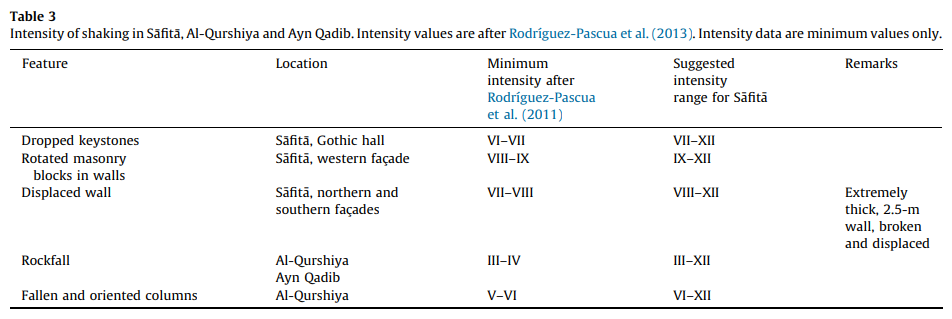 Table 3
Intensity of shaking in Safita, Al-Qurshiya and Ayn Qadib. Intensity values are after Rodrıguez-Pascua et al. (2013). Intensity data are minimum values only
Kázmér and Major (2015:188)
Kázmér and Major (2015:188) produced an Intensity estimate table (below) and assigned a minimum archaeoseismic intensity of IX. They discussed their intensity assessment method as follows:
Shaking intensity is assessed based on earthquake archaeological effects (Rodrıguez-Pascua et al., 2011), and is correlated to the EMS98 (Grunthal, 1998) and ESI07 (Michetti et al., 2007) macroseismic scales in conformity with Rodrıguez-Pascua et al. (2013) (Table 3 below). Most of the correlations we accept here are to the ESI07 intensity scales, except the intensity value for rockfalls, for which we prefer the minimum value of EMS98 instead of the value IV of the ESI07 scale.
The strongest construction type considered by the EMS98 scale is masonry. Safıta — built by opus caementitium or Roman concrete, covered by dressed masonry — is certainly at the most earthquake-resistant end of the building material continuum. Roman concrete walls 2.5 m thick on the upper level certainly can bear higher seismic load than ordinary masonry, where stone is just fitted to stone, even if using mortar. Walls and roofs built of opus caementitium, several metres thick, should have a class of their own, to be included at the top end of the construction materials considered by the EMS98 scale
-
Earthquake Archeological Effects chart
of Rodríguez-Pascua et al (2013: 221-224)
Earthquake Archeological Effects (EAE)
Rodríguez-Pascua et al (2013: 221-224)
| Effect | Location | Photo(s) | Comments | Intensity (EAE) |
Intensity (KM2015) |
|---|---|---|---|---|---|
| Rockfall | Ayn Qadib
Figure 6 Direction of deformation and displacement. Segments of the Levant Fault system after Meghraoui et al. (2003) and Daeron et al. (2007). Paired arrows indicate strong motion directions: north–south deformation in Safıta, and northwards displacement al-Qurshiyya and ‘Ayn-Qadıb. Safıta is 19 km from the Levant Fault. Khirbat al-Qurshiyya and ‘Ayn-Qadıb are both less than 6 km from the Missyaf segment. Al-Marqab citadel bears damages oriented towards 240˚ caused by the AD 1202 earthquake and towards 130˚ caused by an earthquake after 1275 (Kazmer and Major, 2010).
Kázmér and Major (2015)
Ayn Qadibclick on image to explore this site on a new tab in Google Earth |
Figure 5 Rockfall in ‘Ayn-Qadıb village destroyed a masonry house. The largest block (2.6 m thick, ~50 t) fell to 10°N and overturned Kázmér and Major (2015) |
|
V+ | III–XII |
| Rockfall | Khirbet Al-Qurshiya
Figure 4d sketch of displaced objects: approximately north–south lying fallen columns in the village. Twenty-ton blocks — some overturned — in the quarry, displaced to the north. Blocks slid downhill on the eastern slope. Kázmér and Major (2015) |
Figure 4a fallen >20 t block in front of the quarry face. Bedding thickness: ca. 1.4 m. Rubble walls are shepherds’ shelters Kázmér and Major (2015) |
|
V+ | III–XII |
| Fallen and oriented columns | Khirbet Al-Qurshiya
Figure 4d sketch of displaced objects: approximately north–south lying fallen columns in the village. Twenty-ton blocks — some overturned — in the quarry, displaced to the north. Blocks slid downhill on the eastern slope. Kázmér and Major (2015) |
Figure 4c two fallen columns of the village temple lying approximately in a north–south direction (north is towards the viewer) Kázmér and Major (2015) |
|
V+ | VI–XII |
Table 3Intensity of shaking in Safita, Al-Qurshiya and Ayn Qadib. Intensity values are after Rodrıguez-Pascua et al. (2013). Intensity data are minimum values only
Kázmér and Major (2015:188)
Kázmér and Major (2015:188) produced an Intensity estimate table (below) and assigned a minimum archaeoseismic intensity of IX. They discussed their intensity assessment method as follows:
Shaking intensity is assessed based on earthquake archaeological effects (Rodrıguez-Pascua et al., 2011), and is correlated to the EMS98 (Grunthal, 1998) and ESI07 (Michetti et al., 2007) macroseismic scales in conformity with Rodrıguez-Pascua et al. (2013) (Table 3 below). Most of the correlations we accept here are to the ESI07 intensity scales, except the intensity value for rockfalls, for which we prefer the minimum value of EMS98 instead of the value IV of the ESI07 scale.
The strongest construction type considered by the EMS98 scale is masonry. Safıta — built by opus caementitium or Roman concrete, covered by dressed masonry — is certainly at the most earthquake-resistant end of the building material continuum. Roman concrete walls 2.5 m thick on the upper level certainly can bear higher seismic load than ordinary masonry, where stone is just fitted to stone, even if using mortar. Walls and roofs built of opus caementitium, several metres thick, should have a class of their own, to be included at the top end of the construction materials considered by the EMS98 scale
Kázmér and Major (2015:199-189) discussed the causitive fault as follows:
The three locations discussed here have a common element of seismic destruction: an approximately north– south direction of shaking (error ±20° at least).
Safıta is less than 20 km from the Dead Sea Fault. Al-Qurshiyya and ‘Ayn-Qadıb are a mere 5 km away from the Missyaf segment of the same fault. The Yammouneh segment of the Dead Sea Fault, the causative segment for the 1202 earthquake, is only 50 km to the south.
Meghraoui et al. (2003) identified the segments of the Dead Sea Fault. The closest one, the Missyaf segment fractured the last time in AD 1170, i.e. before the construction of the donjon as we see it today in Safıta. The Yammouneh segment faulted in AD 1759 for the last time. It was also responsible for the 1202 earthquake, the largest one in the Near East in historical times (Ambraseys and Melville, 1988; Daeron et al., 2005).
[JW: Daeron et al (2007) present evidence suggesting that the Serghaya, and Râchaïya segments faulted in 1759 CE and the Yammouneh segment faulted in 1202 CE]
Historical data suggest that the AD 1202 earthquake caused the crosscutting damage of Safıta donjon as we see it today. This event is known to have had its epicentre along the Yammouneh fault (Daeron et al., 2007), ca. 50 km south of Safita, not by the Missyaf segment of the Dead Sea Fault, a mere 5 km to the east. The latter slipped in AD 1170. Both seismic events had a similar magnitude, 7.5 (Meghraoui et al., 2003).
| Source | Location | Photo(s) | Comments |
|---|---|---|---|
| Kázmér and Major (2015) | Al-Marqab Citadel ‘Ayn-Qadıb Al-Qurshiyya Chastel Blanc (Safita) |
Figure 6
Figure 6 Direction of deformation and displacement. Segments of the Levant Fault system after Meghraoui et al. (2003) and Daeron et al. (2007). Paired arrows indicate strong motion directions: north–south deformation in Safıta, and northwards displacement al-Qurshiyya and ‘Ayn-Qadıb. Safıta is 19 km from the Levant Fault. Khirbat al-Qurshiyya and ‘Ayn-Qadıb are both less than 6 km from the Missyaf segment. Al-Marqab citadel bears damages oriented towards 240˚ caused by the AD 1202 earthquake and towards 130˚ caused by an earthquake after 1275 (Kazmer and Major, 2010).
Kázmér and Major (2015) |
Map - Direction of deformation and displacement |