Tel Abu Hawam
 Aerial View of Modern Industrial Installations built on top of Tel Abu Hawam
click on image to explore this site on a new tab in govmap.gov.il
| Transliterated Name | Source | Name |
|---|---|---|
| Tel Abu Hawam | Arabic | تل أبو هوام |
| Tell Abu Hawa | Arabic | |
| Tell Abu Huwam | Arabic |
- Fig. 17 Location Map from
Balensi et. al. (1985a)
 Fig. 17
Tel Abu Hawam. Was the eastern cemetery in use as a regional necropolis at the end of the 2nd millenium B.C. ?
Balensi et. al. (1985a) - Annotated Photo showing
location of Tel Abu Hawam in 2011 - from Wikipedia
 Tel Abu Hawam in Haifa Bay as
photographed in 2011. The area of the mound is marked in yellow.
Today, the building of the Electric Company is located on the
highest place in the hill. Excavations in 2002/2001 were carried
out in the place where the bridge now passes north of the mound.
In the excavation, the squares were excavated where the bridge
pillars were later built. The bridge at the bottom of the picture
is the Paz Bridge
Tel Abu Hawam in Haifa Bay as
photographed in 2011. The area of the mound is marked in yellow.
Today, the building of the Electric Company is located on the
highest place in the hill. Excavations in 2002/2001 were carried
out in the place where the bridge now passes north of the mound.
In the excavation, the squares were excavated where the bridge
pillars were later built. The bridge at the bottom of the picture
is the Paz Bridge
(Click on Image for high resolution magnifiable version)
CC BY-SA 3.0 - from Wikipedia - Original topography of the tell
from Stern et. al. (1993 v.1)
 Original topography of the tell
Stern et. al. (2008) - Fig. 4 Topography of Tel Abu Hawam
in 1963 from Balensi et. al. (1985a)
 Fig. 4
Topographic survey of Tel Abu Hawam, contemporary with the 1963
excavations (IEC and IDAM) Balensi et. al. (1985a) - Reconstructed change in
the route of Wadi Kishon/Salman Stream over time - from Wikipedia
 Changes in the route of Wadi Kishon and Salman river over time.
The Kishon originally flowed at the foot of Mount Carmel (I) and moved towards the valley (III)
Changes in the route of Wadi Kishon and Salman river over time.
The Kishon originally flowed at the foot of Mount Carmel (I) and moved towards the valley (III)
(Click on Image for higher resolution magnifiable version)
CC BY-SA 3.0 - from Wikipedia - originally from Avnimelech (1952) - Fig. 2 Tectonics of Haifa Bay
from Balensi et. al. (1985a)
 Fig. 2
Diagram of the main tectonic movements affecting Haifa Bay
Balensi et. al. (1985a) - Fig. 18 Triptych of the Tel and environs
from Balensi et. al. (1985a)
 Fig. 18
Tel Abu Hawam. Triptych uniting the Tel (Fig. 6), the Kishon Delta, and the necropolises (p.120)
- Bastion 67 of level V, facing the mouth of Wadi Salman
- Level V
- Rampart paving located in the extension of Bastion 67, but outside the rampart
- Bank of Wadi Salaman
- Late Bronze Age individual burials, dug in the sand and well preserved
- Tombs eroded by floods and undated (The most numerous)
- Multiple Burial Caves of Iron II
Balensi et. al. (1985a) - Tel Abu Hawam in Google Earth
 Tel Abu Hawam
click on image to explore this site on a new tab in Google Earth - Tel Abu Hawam on govmap.gov.il
Aerial View of Modern Industrial Installations built on top of Tel Abu Hawam
click on image to explore this site on a new tab in govmap.gov.il


- Fig. 4 Topography of Tel Abu Hawam
in 1963 from Balensi et. al. (1985a)
Fig. 4
Topographic survey of Tel Abu Hawam, contemporary with the 1963
excavations (IEC and IDAM) Balensi et. al. (1985a) - Fig. 2 Tectonics of Haifa Bay
from Balensi et. al. (1985a)
Fig. 2
Diagram of the main tectonic movements affecting Haifa Bay
Balensi et. al. (1985a) - Fig. 18 Triptych of the
Tel and environs from Balensi et. al. (1985a)
Fig. 18
Tel Abu Hawam. Triptych uniting the Tel (Fig. 6), the Kishon Delta, and the necropolises (p.120)
- Bastion 67 of level V, facing the mouth of Wadi Salman
- Level V
- Rampart paving located in the extension of Bastion 67, but outside the rampart
- Bank of Wadi Salaman
- Late Bronze Age individual burials, dug in the sand and well preserved
- Tombs eroded by floods and undated (The most numerous)
- Multiple Burial Caves of Iron II
Balensi et. al. (1985a)
- Location Map of Excavations
and Surveys (1929-1984) on the Tel from Balensi et. al. (1985a)
 Fig. 5
Location Map of Excavations and Surveys on the Tel
excavations (IEC and IDAM) Balensi et. al. (1985a) - Location of the
1929-1989 excavations from Stern et. al. (1993 v.1)
 Location of the 1929-1989 excavations
Stern et. al. (2008) - Location of main architectural
remains on the Tel from Balensi et. al. (1985a)

Fig. 6
Tel Abu Hawam. Location of main architectural remains on the Tel
- Bastion, Level III, Iron Age (I-) II
- Level V Wall, Late Bronze
- Bastion 67, level V, Late Bronze
- Level III Wall, Iron II
- Citadel of Level V, Late Bronze
- House 61 (Syro-Hittite), Level V-IV, Iron I
- Level II Wall, Persian period
- Level III period
- Level V Wall, Late Bronze
- Gate of the city of the Late Bronze
- Buttress wall, level V, Middle or Late Bronze
- Repair of the wall of level V, Late Bronze-Iron I
- Casemate, cf. Num. 11
- Level V Temple, Late Bronze
- Level II Wall, Persian period
- Double wall of the Bronze or Iron Age
- Presumed port
Balensi et. al. (1985a) - Axonometric view of the western
section of the Tel from Balensi et. al. (1985a)
 Fig. 11
Axonometric view of the western section of the tell.
Balensi et. al. (1985a)
- Location Map of Excavations
and Surveys (1929-1984) on the Tel from Balensi et. al. (1985a)
Fig. 5
Location Map of Excavations and Surveys on the Tel
excavations (IEC and IDAM) Balensi et. al. (1985a) - Location of the
1929-1989 excavations from Stern et. al. (1993 v.1)
Location of the 1929-1989 excavations
Stern et. al. (2008) - Location of main architectural
remains on the Tel from Balensi et. al. (1985a)
Fig. 6
Tel Abu Hawam. Location of main architectural remains on the Tel
- Bastion, Level III, Iron Age (I-) II
- Level V Wall, Late Bronze
- Bastion 67, level V, Late Bronze
- Level III Wall, Iron II
- Citadel of Level V, Late Bronze
- House 61 (Syro-Hittite), Level V-IV, Iron I
- Level II Wall, Persian period
- Level III period
- Level V Wall, Late Bronze
- Gate of the city of the Late Bronze
- Buttress wall, level V, Middle or Late Bronze
- Repair of the wall of level V, Late Bronze-Iron I
- Casemate, cf. Num. 11
- Level V Temple, Late Bronze
- Level II Wall, Persian period
- Double wall of the Bronze or Iron Age
- Presumed port
Balensi et. al. (1985a) - Axonometric view of the western
section of the Tel from Balensi et. al. (1985a)
Fig. 11
Axonometric view of the western section of the tell.
Balensi et. al. (1985a)
- Excavation areas in
Tel Abu Hawam in the 1985/6, 2001/2002 seasons from Wikipedia
 Excavation areas in Tel Abu Hawam in the 1985/6, 2001/2002 seasons
(Click on Image for higher resolution magnifiable version)
Michal Artzy - Haifa University (2001)
CC BY-SA 3.0 - Wikipedia - Fig. 1 Plan of Phases Va & Vb
from Gershuny (1981)
 Fig. 1
Tel Abu Hawam, Phase Va (shaded) and Vb
Gershuny (1981) - Fig. 2 Plan of Phase Vc
from Gershuny (1981)
 Fig. 2
Tel Abu Hawam, Phase Vc
Gershuny (1981) - Fig. 3 Plan of Phase IVa
from Gershuny (1981)
 Fig. 3
Tel Abu Hawam, Phase IVa
Gershuny (1981)

- Excavation areas in
Tel Abu Hawam in the 1985/6, 2001/2002 seasons from Wikipedia
Excavation areas in Tel Abu Hawam in the 1985/6, 2001/2002 seasons
(Click on Image for higher resolution magnifiable version)
Michal Artzy - Haifa University (2001)
CC BY-SA 3.0 - Wikipedia - Fig. 1 Plan of Phases Va & Vb
from Gershuny (1981)
Fig. 1
Tel Abu Hawam, Phase Va (shaded) and Vb
Gershuny (1981) - Fig. 2 Plan of Phase Vc
from Gershuny (1981)
Fig. 2
Tel Abu Hawam, Phase Vc
Gershuny (1981) - Fig. 3 Plan of Phase IVa
from Gershuny (1981)
Fig. 3
Tel Abu Hawam, Phase IVa
Gershuny (1981)
- Plan of the mound
from Hamilton's Excavations (1932) - from Wikipedia
- Plate III Plan of Stratum III
from Hamilton (1935)
 Plate III
Plan of Stratum III
Hamilton (1935) - Plate IV Plan of Stratum IV
from Hamilton (1935)
 Plate IV
Plan of Stratum IV
Hamilton (1935) - Plate IX Plan of Stratum V
from Hamilton (1935)
 Plate IX
Plan of Stratum V
Hamilton (1935) - Fig. 1 Plan of Stratum V
from Vincent (1935)
 Fig. 1
Tell Abu Hawam. - The city I Level V from QDAP, IV, 1934, pl. v.
Vincent (1935) - Fig. 3 Plan of Stratum IV
from Vincent (1935)
 Fig. 3
Tell Abu Hawam. - The city II Level IV from QDAP, III, 1934, pl. xix.
Vincent (1935)
- Plan of the mound
from Hamilton's Excavations (1932) - from Wikipedia
- Plate III Plan of Stratum III
from Hamilton (1935)
Plate III
Plan of Stratum III
Hamilton (1935) - Plate IV Plan of Stratum IV
from Hamilton (1935)
Plate IV
Plan of Stratum IV
Hamilton (1935) - Plate IX Plan of Stratum V
from Hamilton (1935)
Plate IX
Plan of Stratum V
Hamilton (1935) - Fig. 1 Plan of Stratum V
from Vincent (1935)
Fig. 1
Tell Abu Hawam. - The city I Level V from QDAP, IV, 1934, pl. v.
Vincent (1935) - Fig. 3 Plan of Stratum IV
from Vincent (1935)
Fig. 3
Tell Abu Hawam. - The city II Level IV from QDAP, III, 1934, pl. xix.
Vincent (1935)
- Architecture and Stratigraphy
of Stratum III from Balensi et. al. (1985a)
 Architecture and Stratigraphy of Stratum III by M.-D. H.
Balensi et. al. (1985a) - Fig 8 Cross-section
- Guide to Stratigraphy of the Tel from Balensi et. al. (1985a) (modified from Hamilton, 1935)
 Fig. 8
Tel Abu Hawam. Guide to reading the stratigraphic section of the tell published by RW Hamilton (cf. QDAP, III, 1934, pl. XIX = QDAP, W, 1935, facing p. 1).
Balensi et. al. (1985a) - Plan of the Tell with
location of cross-section (ɸ) from Hamilton (1935)
 JW: Plan of the Tell with location of cross-section
Hamilton (1935)
- Architecture and Stratigraphy
of Stratum III from Balensi et. al. (1985a)
Architecture and Stratigraphy of Stratum III by M.-D. H.
Balensi et. al. (1985a) - Fig 8 Cross-section
- Guide to Stratigraphy of the Tel from Balensi et. al. (1985a) (modified from Hamilton, 1935)
Fig. 8
Tel Abu Hawam. Guide to reading the stratigraphic section of the tell published by RW Hamilton (cf. QDAP, III, 1934, pl. XIX = QDAP, W, 1935, facing p. 1).
Balensi et. al. (1985a) - Plan of the Tell with
location of cross-section (ɸ) from Hamilton (1935)
JW: Plan of the Tell with location of cross-section
Hamilton (1935)
- Painting showing Tel Abu Hawam
from 1840 - from Wikipedia
 Tel Abu Hawam as painted in 1840 by the English painter William Henry Bartlett.
On the ridge of the mountain, the Burj E-Salam citadel.
Tel Abu Hawam as painted in 1840 by the English painter William Henry Bartlett.
On the ridge of the mountain, the Burj E-Salam citadel.
(Click on Image for higher resolution version)
Public Domain - Wikipedia from Collection of the Israel National Maritime Museum - Late 19th or Early 20th century
photo of Haifa Bay showing no mound (tel) - from Wikipedia
 View of Haifa Bay from the northern
slopes of Mount Carmel, in the first half of the 20th century
[JW: or maybe 1898].
You can see the mouth of the Kishon River in the place where
the mound used to be
View of Haifa Bay from the northern
slopes of Mount Carmel, in the first half of the 20th century
[JW: or maybe 1898].
You can see the mouth of the Kishon River in the place where
the mound used to be
Public Domain - from Wikipedia

 Balensi and Herrera's Stratigraphy
(Revision following the 1985-1986 Excavations)
Balensi and Herrera's Stratigraphy
(Revision following the 1985-1986 Excavations)Stern et. al. (2008)
 Stern et. al. (1993 v. 1)


- Location of main architectural
remains on the Tel from Balensi et. al. (1985a)
Fig. 6
Tel Abu Hawam. Location of main architectural remains on the Tel
- Bastion, Level III, Iron Age (I-) II
- Level V Wall, Late Bronze
- Bastion 67, level V, Late Bronze
- Level III Wall, Iron II
- Citadel of Level V, Late Bronze
- House 61 (Syro-Hittite), Level V-IV, Iron I
- Level II Wall, Persian period
- Level III period
- Level V Wall, Late Bronze
- Gate of the city of the Late Bronze
- Buttress wall, level V, Middle or Late Bronze
- Repair of the wall of level V, Late Bronze-Iron I
- Casemate, cf. Num. 11
- Level V Temple, Late Bronze
- Level II Wall, Persian period
- Double wall of the Bronze or Iron Age
- Presumed port
Balensi et. al. (1985a) - Axonometric view of the western
section of the Tel from Balensi et. al. (1985a)
Fig. 11
Axonometric view of the western section of the tell.
Balensi et. al. (1985a) - Cross-section - Guide to Stratigraphy
of the Tel from Balensi et. al. (1985a) (modified from Hamilton, 1935)
Fig. 8
Tel Abu Hawam. Guide to reading the stratigraphic section of the tell published by RW Hamilton (cf. QDAP, III, 1934, pl. XIX = QDAP, W, 1935, facing p. 1).
Balensi et. al. (1985a) - Plan of the Tell with location
of cross-section (ɸ) from Hamilton (1935)
JW: Plan of the Tell with location of cross-section
Hamilton (1935) - Plan of Stratum V
from Hamilton (1935)
Plate IX
Plan of Stratum V
Hamilton (1935) - Plan of Stratum V (Vincent)
from Vincent (1935)
Fig. 1
Tell Abu Hawam. - The city I Level V from QDAP, IV, 1934, pl. v.
Vincent (1935)
- Location of main architectural
remains on the Tel from Balensi et. al. (1985a)
Fig. 6
Tel Abu Hawam. Location of main architectural remains on the Tel
- Bastion, Level III, Iron Age (I-) II
- Level V Wall, Late Bronze
- Bastion 67, level V, Late Bronze
- Level III Wall, Iron II
- Citadel of Level V, Late Bronze
- House 61 (Syro-Hittite), Level V-IV, Iron I
- Level II Wall, Persian period
- Level III period
- Level V Wall, Late Bronze
- Gate of the city of the Late Bronze
- Buttress wall, level V, Middle or Late Bronze
- Repair of the wall of level V, Late Bronze-Iron I
- Casemate, cf. Num. 11
- Level V Temple, Late Bronze
- Level II Wall, Persian period
- Double wall of the Bronze or Iron Age
- Presumed port
Balensi et. al. (1985a) - Axonometric view of the western
section of the Tel from Balensi et. al. (1985a)
Fig. 11
Axonometric view of the western section of the tell.
Balensi et. al. (1985a) - Cross-section - Guide
to Stratigraphy of the Tel from Balensi et. al. (1985a) (modified from Hamilton, 1935)
Fig. 8
Tel Abu Hawam. Guide to reading the stratigraphic section of the tell published by RW Hamilton (cf. QDAP, III, 1934, pl. XIX = QDAP, W, 1935, facing p. 1).
Balensi et. al. (1985a) - Plan of the Tell with location
of cross-section (ɸ) from Hamilton (1935)
JW: Plan of the Tell with location of cross-section
Hamilton (1935) - Plan of Stratum V
from Hamilton (1935)
Plate IX
Plan of Stratum V
Hamilton (1935) - Plan of Stratum V
from Hamilton (1935) - magnified
Plate IX
Plan of Stratum V
Hamilton (1935) - Plan of Stratum V (Vincent)
from Vincent (1935)
Fig. 1
Tell Abu Hawam. - The city I Level V from QDAP, IV, 1934, pl. v.
Vincent (1935)
- Fig. 2
Tectonics of Haifa Bay from Balensi et. al. (1985a)
Fig. 2
Diagram of the main tectonic movements affecting Haifa Bay
Balensi et. al. (1985a) - Fig. 4
Topography of Tel Abu Hawam in 1963 from Balensi et. al. (1985a)
Fig. 4
Topographic survey of Tel Abu Hawam, contemporary with the 1963
excavations (IEC and IDAM) Balensi et. al. (1985a) - Fig. 5
Location Map of Excavations and Surveys (1929-19840 on the Tel from Balensi et. al. (1985a)
Fig. 5
Location Map of Excavations and Surveys on the Tel
excavations (IEC and IDAM) Balensi et. al. (1985a) - Fig. 6
Location of main architectural remains on the Tel from Balensi et. al. (1985a)
Fig. 6
Tel Abu Hawam. Location of main architectural remains on the Tel
- Bastion, Level III, Iron Age (I-) II
- Level V Wall, Late Bronze
- Bastion 67, level V, Late Bronze
- Level III Wall, Iron II
- Citadel of Level V, Late Bronze
- House 61 (Syro-Hittite), Level V-IV, Iron I
- Level II Wall, Persian period
- Level III period
- Level V Wall, Late Bronze
- Gate of the city of the Late Bronze
- Buttress wall, level V, Middle or Late Bronze
- Repair of the wall of level V, Late Bronze-Iron I
- Casemate, cf. Num. 11
- Level V Temple, Late Bronze
- Level II Wall, Persian period
- Double wall of the Bronze or Iron Age
- Presumed port
Balensi et. al. (1985a) - Fig. 8
Cross-section - Guide to Stratigraphy of the Tel (by Hamilton) from Balensi et. al. (1985a) (modified from Hamilton, 1935)
Fig. 8
Tel Abu Hawam. Guide to reading the stratigraphic section of the tell published by RW Hamilton (cf. QDAP, III, 1934, pl. XIX = QDAP, W, 1935, facing p. 1).
Balensi et. al. (1985a) - Plan of the Tell with
location of cross-section (ɸ) from Hamilton (1935)
JW: Plan of the Tell with location of cross-section
Hamilton (1935) - Fig. 11
Axonometric view of the western section of the Tel from Balensi et. al. (1985a)
Fig. 11
Axonometric view of the western section of the tell.
Balensi et. al. (1985a) - Fig. 17
Location Map from Balensi et. al. (1985a)
Fig. 17
Tel Abu Hawam. Was the eastern cemetery in use as a regional necropolis at the end of the 2nd millenium B.C. ?
Balensi et. al. (1985a) - Fig. 18
Triptych of the Tel and environs from Balensi et. al. (1985a)
Fig. 18
Tel Abu Hawam. Triptych uniting the Tel (Fig. 6), the Kishon Delta, and the necropolises (p.120)
- Bastion 67 of level V, facing the mouth of Wadi Salman
- Level V
- Rampart paving located in the extension of Bastion 67, but outside the rampart
- Bank of Wadi Salaman
- Late Bronze Age individual burials, dug in the sand and well preserved
- Tombs eroded by floods and undated (The most numerous)
- Multiple Burial Caves of Iron II
Balensi et. al. (1985a) - Architecture and
Stratigraphy of Stratum III from Balensi et. al. (1985a)
Architecture and Stratigraphy of Stratum III by M.-D. H.
Balensi et. al. (1985a)
3. — EXCAVATIONS OF 1932-1933.
Two campaigns, led by R.W. Hamilton, provided results that made the site famous thanks
to the publication of excavation reports that were exemplary in terms of the speed of
their publication and the concise and structured nature of their presentation. No doubt
it should be remembered that the references provided by Meggido, Tell Beit Mirsim, etc.,
were still to come, as well as the main synthesis studies on Cypriot and Aegean productions.
Many more or less constructive comments gradually came to expand the bibliography of
Tell Abou Hawam. These contributions attest that, for half a century, the site has
been the subject of increasing speculation in terms of chronology, trade and cultural
influences, among specialists dealing with the Eastern Mediterranean between the end of
the Middle Bronze and the Hellenistic period. The contribution of “new” data from old
excavations can therefore only receive a favorable welcome since it stimulates international research.
The available sources of information have already been mentioned in the 1982 report.
According to the numerous photographs, the limits of the excavations appear to have been,
to within a few tens of centimeters, those of the peripheral structures presented on the plans
published in 1935 (Fig. 5; pl. V, b).
It must be emphasized here that
- during his first campaign, the excavator explored as quickly as possible the northern half of what apparently remained of the tell after the earlier destructions
- that the discovery of the material associated with the superimposed temples 30 and 50 (part of the parallels of which are only found on the most prestigious sites: Our, Assour, Mari, Râs Shamra, Rhodes, Enkomi..., cf. fig. 1)9 meant that the importance of the site - small, destroyed and without any attraction - could no longer escape the authorities
- that careful attention was therefore paid to the stratigraphy during the second campaign, devoted to the southern half of the tell
- that the recording system then developed on site is different and more accurate than that subsequently published
- that the conclusions that can be drawn from this site stratigraphy are chronologically consistent
- that the chrono-stratigraphic corrections which have already been proposed (1982 report) concerning levels IV and V, therefore directly reflect the observations made in the field by Hamilton.
 Balensi et. al. (1985a)
It must therefore be understood that the sequence of levels I to V proposed by the excavator in his publication is a synthetic interpretation and, as such, revisable. That said, it would be premature to provide replacement terminology here, as too many questions still remain unanswered, in particular those related to the history of the fortifications.
3C1. — Stratigraphy.
R.W. Hamilton presents stratum III as a level clearly limited by two layers of fire: based on the
layer that seals the destruction of stratum IV, stratum III is itself sealed by a burnt layer;
Then comes a notable period of abandonment which precedes the installation of stratum II.
According to the published plan (see QDAP, IV, 1935, pl. III), this level III consists of a fairly
dense set of adjoining rooms (no.s 13 to 24 and 27), as well as isolated buildings (no.s 11, 12, 25, 26).
In his first report, the excavator specifies that this stratum sometimes reaches a thickness of 2 m
and indicates more than one phase of construction, but without detailing further; in his second
report, he speaks soberly of the areas disturbed by later occupations and condenses rooms 13 to 21
under the name of “Period III” because of their architectural unity. In addition, the city had an
enclosure wall of which some foundation courses remain to the south-west, to which would have
been attached a narrower section of wall and a "bastion" to the north-west. The whole,
without phase distinction, is dated by Hamilton to “1100-925 (?) B.C.”.
While it is only a question of a single layer of fire separating strata IV and III, the published
stratigraphic section (cf. fig. 8) shows at least two, clearly separated in time, although
practically confused: in chronological order, a first layer of ashes seals all or part of
houses 44 and 45, passing under house 36, also assigned to level IV; a second layer thickens
the first above Building 44, but separates farther east to seal House 3611.
- Plan of the
Tell with location of cross-section (ɸ) below from Hamilton (1935)
JW: Plan of the Tell with location of cross-section
Hamilton (1935)
Fig. 8Tel Abu Hawam. Guide to reading the stratigraphic section of the tell published by RW Hamilton (cf. QDAP, III, 1934, pl. XIX = QDAP, W, 1935, facing p. 1).
Balensi et. al. (1985a)
During the lapse of time between these two fires — to be clearly distinguished — several structures of stratum III were built12. On the second layer of ash, towards the center of the tell, other level III structures then appear there13. Further to the east and still visible on the section, other ashy layers are superimposed, suggesting even later fires, but which occurred before the end of stratum III.
The organization of all the phases that could be distinguished within level III as published in 1935, can be done with a sufficient degree of certainty, on the one hand by considering the relationships between the layers of destruction and the associated buildings, and on the other hand by detecting the architectural incompatibilities between the structures recorded by the excavator.
Architecture and Stratigraphy of Stratum III by M.-D. H.Balensi et. al. (1985a)
3C2. — Architecture and stratigraphy.
It is the meticulous study of the architectural remains of squares DE, 3-4 which serves as the basis for the reasoning14. Schematized in an attached table, the results of the analysis show at least six definite phases of construction. It is undoubtedly necessary to underline the pivotal role played by building 27, which came under level IV on the site as in Hamilton's preliminary report and was then reassigned to level III in its final report15. Room 25 was partially reused during the reoccupation of the places corresponding to stratum II.
Pieces 13 to 21 constituting “Period III” form a set with no evidence that could suggest several independent phases of construction; this set is however not homogeneous because most of the walls have been reused, which implies a minimum of two phases of occupation. This “period”, shorter than stratum III, cannot be identified with it; but its exact stratigraphic position in the sequence is difficult to establish due to insufficient information. A number of clues, however, allow us to conceive that this island is after the construction of building 27 and that the use of rooms 18 to 20, at least, ceased before the end of level III16.
With regard to the fortifications located in the northwest quarter of the tell, Hamilton's final report suggests that the bent rampart of squares D-E, 1 (better preserved in its northern part and built in a jagged pattern towards the south) has had to be connected to the large bastion of square C2 (fig. 6.) These structures were known from the first campaign of excavations and the preliminary report proposed another interpretation; the bastion and the southern section of this surrounding wall belonged to level IV, while the central part was not distinct from level V. The impression prevails that, during the second campaign, the excavator having found the rampart of stratum III to the southwest and not having identified a defensive system specific to stratum IV, reluctantly reinterpreted all these elements as belonging to level III17.
The reattribution of the bastion was justified by the pottery — which has remained unpublished — which was associated with it18: the only fragment found which is in fact useful19 is a shard of a plate with red engobe of the so-called type "from Samaria" (fig. 9, n° 8); however, it was collected in the corridor which separates the platform from the outer wall in the shape of a horseshoe; it cannot therefore suffice to date the construction of this set which has never been dismantled by Hamilton or by Anati (excavations of 1963). Being isolated from the other structures of level III, this bastion cannot be attached to any of the architectural phases shown schematically in the attached table. Only an excavation of the preserved parts could confirm that it does not belong to level IV...
3C4. — Chronology.
The presence of this shard from the Geometric period puts the date of the end of level III until the
middle of the eighth century at the earliest. The material briefly mentioned above falls well
within a chronological gap extending from the beginning of the tenth century to the years 750
and perhaps even 700. The two main periods known for the evolution of Phoenician ceramics41
are clearly represented in stratum III from Tell Abu Hawam, which finds excellent parallels in Tyre
(str. II to XII), Sarepta (str. C and D), Keisan (levels 5 to 8), Megiddo V A-IV B,
Qasile IX, etc. Certain absences can be significant: the torpedo jars and the plates with
rims or spread lips which characterize the Keisan level IV (700-650)42; or even the
bobèche jugs with a glossy red engobe that appear in Tyre II - III (760-700) could serve as
a reference to characterize the end of Hamilton's stratum III.43
 Balensi et. al. (1985a)
Two fundamental points emerge from the preceding lines: on the one hand, all the architectural remains and ceramics fit perfectly into a Phoenician context; on the other hand, the above chronologies can no longer be maintained once unpublished material is taken into consideration. It is legitimate to recall here the intuition of Father Vincent o.p. who, from 193544, sensed both the necessarily Phoenician character of the site, as well as the historical probability of an occupation of the place at least until the Assyrian conquest, if not later!
It finally turns out that, in the history of research, Tell Abu Hawam served, a few decades ago, to date approximately the beginning of the Geometric period in Greece. Today, it is this Aegean chronology that helps it find its place in the ancient history of the Mediterranean Near East. The revision of the documentation kept by RW Hamilton is also fully justified here.
GENERAL RESULTS
-
Traces of occupation going back to the Middle Bronze II period
are attested by a few finds, not properly stratified in Hamilton's Stratum V.5
None of this material is stylistically later than Megiddo X or Beth-shan X—XA; if it is all
from a single period, a date around 1600 B.C. should be considered (fig. 1).
Since no structure is necessarily to be assigned to MB, it is premature to speak yet of the foundation of the site. It would seem logical, however, keeping in mind the increasing density of strategic settlements in the "Hyksos" period, as at Tel Mor (Dothan 1973), to assign the base level to MB IIB—C. -
Five horizons can be isolated within the Late Bronze period, separated by violent destructions.
They all belong to Stratum V (the last horizon is the first stage of Hamilton's Phase Vb).
They reflect, successively
- Megiddo IX (believed to have been destroyed by Thutmosis III6)
- Megiddo VIII (2 periods: Amenophis III7 and El Amarna8)
- Megiddo VIIb (2 periods, contemporary with the Egyptian 19th Dynasty).9
Clearly, Cypriot and Canaanite finds coexist prior to any identified Aegean remains. The Cypriot corpus comprises about 200 items, of which about 90 percent are unpublished; they range from the end of the Late Cypriot IA to IIC periods, and include not only small finds such as figurines, a cylinder seal, and statuettes (fig. 2), but also a wide repertoire of ceramic wares and shapes10 that indicate the relations with the coast south and east of the island.
Even compared to large cities like Enkomi and Ugarit with rich cemeteries, Tell Abu Hawam is an outstanding site with its collection of over 700 Aegean imports. Although still unconfirmed, the presence of material earlier than Late Minoan and Mycenaean IIIA2e (contemporary with Amenophis III) and later than IIIB (i.e., the 19th Dynasty) cannot be ruled out. The bulk of the collection consists of Mycenaean IIIA2b (El Amarna period and, possibly, the end of the 18th Dynasty) and Mycenaean IIIB; by then, statistics show that imports more than doubled. In the earlier period, the available repertoire is roughly similar to that of El Amarna and Mycenae; in the latter, it has become larger than at Mycenae itself, owing to the Levanto-Mycenaean production. However, the quantity of figure patterns remained constant during the 14th and 13th centuries, accompanied by a growing tendency toward linear decoration.11 In Cyprus and the Near East, it is normal to find more closed shapes than open ones; at Tell Abu Hawam, the proportion is well balanced during the Mycenaean IIIB and possibly also the IIIA2b periods. As elsewhere, the stirrup jar dominates the market, but it is still not as common at the site as drinking vessels on the whole, i.e., cups plus kylikes and chalices. The relative frequency of shapes is quite different from that of Cyprus, but very close to what has been found in the Aegean.12 Neutron activation analysis has attested to specific trade connections between Tell Abu Hawam and the Argolid (Perlman 1973: 215).
Three arguments, possibly convergent, may contribute to a better understanding of these unusual features. One was well formulated already by Hankey (1967: 146): "Cypriote importers took the cream of the supply since it reached them first (and they had copper to trade back), and the Middle East in general got the left-overs." But most of the available repertoire from the site fits local needs perfectly, with similar shapes in much finer quality, thus giving root to the idea of complementarity. The only exception would be the shallow cup: fragments of more than 100 such items were scattered all over the site. They may be a sign, although not a decisive one, of some Mycenaean presence.
The history of the LB fortifications is not altogether clear. The long wall with inner salients, undated previously (Gershuni 1981: 37), is now known to have been out of use from the El Amarna period onward (at least in its eastern section). Thus the settlement was provided with a city wall possibly at the time of Amenophis III at the latest, or, more likely, during the maritime policy of Thutmosis III and IV in the 15th century B.C. — if not even earlier (below).
As far as the cyclopean fortifications are concerned, they may antedate the 19th Dynasty and be simply reused in the 14-13th centuries. Complex 66, which rests partly on and encompasses the eastern half of the citadel, has a system of latrines known also in the Ashlar Building, along with a megaron, at Enkomi IIIa (Dikaios 1969, I: 178; III: 273-75; French 1980: 268). Thus this complex is able in itself to offer some kind of Aegean architectural context for the amazing frequency of Mycenaean III imports discovered in this sector.13 Furthermore, there are striking similarities between the citadel of Tell Abu Hawam and the West Building at Tacanach, redated to MB IIC by Lapp (1964: 15).14 Whatever the period of construction may have been, the fortifications may have been a Canaanite tradition; and the possibility of Egyptian influence in the background cannot be excluded (contra Weinstein, 1980).15 Analysis of Anati's soundings, now in progress, should contribute to the solution of this problem. - Attention should be paid to the question of the transition between the Late Bronze and Iron Age periods. No material attributed to Stratum V in the field is later than ca. 1200 B.C.,16 although Stratum V in Hamilton's report includes 11th century B.C. ceramics and small finds.17 That is, the gap in occupation, proposed by Mazar — if any at all -18 is to be looked for within Phase Vb of the preliminary reports, not between Strata V and IV (Maisler 1951: 25; Anati 1975: 12), or between Phases IVa and IVb (Van Beek 1955: 38, n. 15; Wright 1961: 97; Gershuni 1981: 44).
-
Iron I comprises five distinct periods of construction divided between Phases Vb19 and IVa-b
of the preliminary reports. They include an attempted fortification wall at 61-63 and temple 30.20
The domestic structures reflect clearly the arrival of a new population, coming probably from northern Syria21
at the time or soon after the appearance of the Phoenician bichrome ware. The proper historical context for
such a movement, around 1100 B.C., is the war of Tiglath Pileser I of Assyria against the Arameans.
A violent fire put to an end the period of isolated T-partitioned square houses sometime in the mid-11th century.22
Following the same plan, organized rebuilding took place in the southwest quarter of the mound; it shows the same tradition of wall construction, with a row of small stones alternating with two larger ones. This technique still appears in the next stage of construction, in what is probably the "manor house" of a small village.23
Thereafter the structures are normally characterized by the Phoenician pillared technique (Elayi 1980: 165), as first attested in the so-called store galleries of Phase IVb. This occupation illustrates the appearance, as yet unpublished, of the black on red style (Room 31), in connection with the usual bichrome ware (continuously represented since Phase Vb). By then the material culture is similar to that of Qasile X; both destructions, ca. 1000 B.c., may have had the same — possibly Davidic — origin. -
Iron IIA is represented essentially by Stratum III. But 10th century finds (i.e., later than the horizon
at the southwest quarter and at the burnt galleries of Phase IVb) are already part of field
Stratum IV; the latter included remains of occupation earlier than Stratum III fortifications
and Hamilton's "Period III" (that is Rooms 13-21). The key is Building 27, described as a
connecting link between Strata IV and III. This building had been planned in direct relation
with its predecessor to the south, Mansion 3-32 of Phase IVb, i.e., prior to Period III.
Since it was somehow neglected in previous studies, the lack of stratigraphical homogeneity within Stratum III must be underlined here.24 This basic feature is of utmost importance, because for nearly half a century the chronology of the early Geometric period in Greece has rested on two published Aegean imports found at Tell Abu Hawam (Coldstream 1968: 302-10). -
Iron II is characterized by a complex sequence, still under careful study by D. Herrera.
It should be enough to say that occupation is attested until at least the 8th century B.C.
What can be deduced from the existence of late Samaria ware (as described by Hamilton for Rooms 13-14)25
is confirmed by unpublished data, e.g., an Aegean import that stylistically is not earlier than the
Dipylon in Athens, ca. 750 B.C. (fig. 3).
Through the wide repertoire of local and foreign finds, it has become clear that the city was quite active, not only in the latter part of the reign of Solomon, but also during the whole of the Divided Monarchy. However, the absence of a casemate rampart or of any four-roomed houses makes it likely that Tell Abu Hawam was Phoenician rather than Israelite.
- What happened during Iron Age IIC, i.e., in the Neo-Assyrian and the Neo-Babylonian periods? Possibly there was a gap in occupation, but it was certainly shorter than was previously thought. Further work is still required before any valid conclusions can be drawn.26
- As regard the Persian period, none of the poor architectural remains of Phase IIa can be properly dated. But Greek imports ranging from the 6th to the 5th centuries B.c. have been found below the rebuilt and fortified city of Phase IIb. Stern (1968) has also stressed the lack of Alexandrian coins in the hoard linked to Phase IIb, suggesting a destruction at the eve of the Hellenistic period. Since unpublished data, including more Greek imports, are available from Hamilton's and Baramki's excavations,27 a systematic check must be made to give an overall view of these periods (fig. 4) and those later still.
5 Generally scattered over the area or somewhat concentrated near Well 56 were MB
fragments from a piriform juglet with button base, a red burnished dipper juglet,
a red-on-black Cypriot bowl, and - possibly the scarab (Hamilton 1935: no. 402)
illustrated in fig. 1.
6 Fragmentary chocolate-on-white bowls, Cypriot base ring I trefoil juglets,
bichrome kraters, etc., were spread mainly along an east-west axis, from
Temple 50 to the Citadel via the square E5 Well at Locus 56, and at low
levels in Locus 67 to the north.
7 The same pattern of occupation is attested through unrestorable Late
Minoan and Mycenaean IIIA:2e vessels, most of which are burnt. Also damaged
by fire are the published group no. 263 et al., found west of Locus 56;
they may belong to the previous Thutmosis III horizon, or to the reign of
Amenophis III at the latest. Not earlier than the second half of the
15th century B.C. is the Cypriot flat-based, large Milk Bowl, no. 31Od;
it was discovered (with unpublished local painted fragments of domestic
jars and biconical vessels) by the tabun in square D5, under the interior of
Building 52 (which is incorrectly interpreted by Gershuni 1981).
8 The early house in Locus 59 and the architectural remains immediately
east of it show the highest concentration of Mycenaean IIIA:2b imports,
plus signs of the transition into Late Minoan IIIB and Mycenaean IIIB: I.
Similar features appear in Temple 50 (before the destruction by fire
of its west porch), where quantities of Mycenaean IIIA:2b are smaller than
those, in diminishing order, at Locus 67-66 to the northwest, in
Square E3 and EF3 (Citadel sector) and around Well 56 (i.e., north of Complex 59).
9 These horizons are characterized by an overwhelming quantity of
Mycenaean IIIB, generally fragmentary and stratigraphically
contemporary with Cypriot and Egyptian imports. A violent destruction
by fire happened after the appearance of Mycenaean IIIB:2 and
the Cypriot Rude Style. All sectors of the tell were touched,
including those of the Citadel and Temple 50 (now provided with
the four column bases and a central stone-lined pit). In both places,
as well as to the south (Complex 59-60), reoccupation is attested by
unburnt, stylistically later imports, comprising the Gray "Minyan"
ware (Troy VI/VII: its earlier occurrence cannot be proven); they were
still in use at the time of sporadic fires like those in Loci 51 and
upper 58. The construction of the latter shows that Well 56 in
Square E5 was no longer in use; it seems to have been replaced
by the well south of Locus 52 in Square D5 (9.65-6.75), which
yielded only burnt fragments, all of them Mycenaean IIIB but
for one local LB IIB painted krater.
10 Apart from the red-on-black ware already mentioned (n. 5),
the following Cypriot wares have been identified: black slip,
bichrome (wheelmade), monochrome, pseudo-monochrome (ladles),
base ring I (thin ware and thick ware), base ring II (hand and
wheel made), white slip I, IIA, II and "III," white shaved
(including jug no. 229), coarse (wall brackets, cooking pot no. 238),
plain white wheelmade I, pithos ware, white painted V, white painted
wheelmade II, and, more recently, handmade bucchero. Eight
zoomorphic pots and statuettes (no. 286 [fig. 2], 302-305,
plus three unpublished) and the fragments of three female
figurines (no. 319-321) illustrate the typical Late Cypriot II
repertoire (Catling 1976; V. Karageorghis 1978; J. Karageorghis 1977: 75, 83);
all of them are related to base ring ware. The study of the large Cypriot
corpus has benefited from the advice of R. S. Merillees, E. Oren, and
M. Yon-Calvet, to whom the author wishes to express thanks.
11 Without the comprehensive experience of V. Hankey, assisted by E. French,
the analysis of the Aegean corpus would have never reached its present stage; the author
is much indebted to both of them for their most generous contributions. In the more
than 700 items from Hamilton's excavations at Tell Abu Hawam, over 500 can be classified
typologically, and 160 are decorated with identifiable patterns, following Furumark's
principles (1941) and E. French's up-to-date contributions for the Argolid. On the
horizon of Mycenaean IIIA:2b, Tell Abu Hawam offers a range of 21-25 shapes (FS) and
22 motifs (FM); 25 FS and 30 FM were identified by French at Mycenae, while 22 FS and
18-23 FM were noted by Hankey at El Amarna (1973: 129). On the Mycenaean IIIB horizon,
French has registered 22 FS and ca. 30 FM, while the presently available TAH corpus
offers 25-35 FS and 22-23 FM.
12 Comparative data for the Mycenaean ceramic forms are tabulated below (cf. Astrom 1973: 125)
 Comparative data for the Mycenaean ceramic forms
Balensi (1985b)
13 Nearly half of the large Mycenaean IIIB collection was found in the western third of the tell, extending over Loci 63 to 68. But in no way are the Citadel and Complex 66 specifically identified in the field code. The objects are simply labelled as having been found below the houses of Phase Va; even Mycenaean IIIA:2b is represented at the foundation and floor levels of Houses 44 and 45, that is to say, much too high above the remains of the Citadel, compared to the rather good state of preservation of the later latrine complex at Locus 66 (see the sole published stratigraphical section in Hamilton 1934, 1935).
14 Noted similarities are: orientation, mezzi building stone from Mt. Carmel, thickness of walls, type of plan, proportions of layout (3/3 for Ta'anach and 4/3 for Tell Abu Hawam).
15 Compared to Megiddo and Beth-shan, the lack of impressive remains at Tell Abu Hawam is particularly striking - if it was really an Egyptian naval base as suggested by Mazar (1951), a hypothesis contradicted by Weinstein 1980. But in any case, some kind of Egyptian presence in the vicinity has to be presumed:
- From an architectural point of view, Temple 50 is evocative of some Egyptian chapels like that at El Kab (Vandier 1955: 840, fig. 405), although this is not decisive. More interesting are the similarities between the early house in Locus 59 and contemporary domestic units in the worker's village at El Amarna. They are both built on a rectangular base (5 x 1O m, with 0.6 m thick walls), i.e., a tripartite plan with two backrooms (Peet and Woolley 1923: 55, pl. 16).
- More 18th and 19th Dynasty finds have been identified during the revision process, including ceramics (hemispherical red bowls, date-shaped jars, etc.); possibly two of them belong to the earliest field phase of occupation.
- One must keep in mind the state of destruction of the site (including the sector of the Citadel) prior to Hamilton's excavations, as well as the fact that objects were known to be already on the antiquities market in Haifa.
- Obviously the economic factor must not be dissociated from the strategic location of the mound. The logical assumption is that it was in Egyptian interests to support the security of the place through some kind of military presence in the immediate vicinity. Akko may have been the major naval base, with Tell Abu Hawam as the commercial harbor.
- The presumed occupational gap in the 12th century is odd (n. 18). Should not Ramses III have settled a group of the "Sea Peoples" to ensure lasting Egyptian control?
16 This includes Late Minoan UIB matte-surfaced "oatmeal" ware and a cup in zigzag heavy style with monochrome inside; Mycenean IIIB:2 small deep bowls (FS 284B); Cypriot rude style kraters; and gray Trojan ware, often known as "Minyan."
17 Phoenician bichrome jugs, no. 249 and 250 from the room north of Locus 56, et al., published group no. 244 from below and on the pavement in Building 55 (with a T-shaped partition wall); jug no. 251 from above the pavement level in Building 53; Aegean glass spiral pinheads no. 394c from Temple 30 (L. Astrom 1972: 597, n. 6 Late Cypriot IIIB).
18 A 12th century gap in occupation seems to be reflected by the apparent lack of imported Mycenean IIIC (including the early linear style), Cypriot bucchero wheelmade and proto white painted wares, and local Mycenaean IIIC and Philistine productions. However, no definite answer can be given as long as the whole available corpus from Tell Abu Hawam has not been checked (see n. 3).
19 The first known period unites Building 55 (the remains at Locus 54-55 W. could well be 12th century), the room north of Locus 56, the upper remains in Locus 52, the walls northeast of 3- Vb (belonging to field Stratum IV), and Temple 30. Iron Age ceramics were found already below the above-mentioned Loci 55 and 56 N (which were also part of field Stratum IV). The second period witnesses the appearance of the long wall south of Locus 52, leaning against the inner west wall of Temple 30 and Houses 61, 62, and Locus 53.
20 The material associated with the so-called "floor of Temple 30" is late LB IIB, including imports. It comes from a layer of hard earth and ashes, mixed with sand, identified by the excavator as a filling by the foot of the standing pillar (Hamilton 1934: 76/77). Such a layer can be traced through the published section and field photographs, below the walls of Temple 30; thus these objects are necessarily earlier than this structure and correspond to the last reoccupation in Temple 50.
On the other hand, the plan and orientation of Temple 30 are similar to those of the Northern Temple (dedicated to 'Anat) at Beth-shan in Stratum V Lower (i.e., 10th century B.C.). This level has produced a SyroPalestinian statuette of the same type as Hamilton's no. 370 (Negbi 1976: 46, no. 1447, 1448). A movement of cultic influence southward sometime during the transitional period between that Late Bronze and the Iron Age can be presumed from the fact that this type of idol, not known in ancient Syria after the 12th century B.C., does appear around this time and afterward in coastal and central Palestine (Negbi 1976).
Whether the gold leaf-coated bronze statuette from Tell Abu Hawam belongs to Temple 50 or 30 cannot be stratigraphically determined. In the former case, it would tend to link the site to the north Canaanite culture as at Ugarit in the 14th-13th centuries; in the latter case, it would underline the lack of Israelite orthodoxy at the site (cf. 2 Kgs 3:2; 10:26; Ex 23:24;34:13).
21 The origin of this type of structure lies in the Fertile Crescent, as can be seen in architecture characteristic of Meskene-Emar in the Euphrates Valley, during the 14th-13th centuries B.C., a Hittite foundation with parallels from Anatolia at Boghaz Koy (Margueron 1980: 285); but the real prototype is as early as the third millennium, as seen at Tell Asmar-Eshnunna in southern Mesopotamia (Delougaz et al. 1967: pl. 27:30).
Though rare, the square house with a T-shaped partition wall is not totally unknown in Palestine. The MB II "Patrician House" at Tell Beit Mirsim (Stratum D) shows affinities with Chagar Bazar in the Habur region, according to Albright (1938: 36, 37, nn. 19-20). The domestic quarter, facing the Syro-Hittite Stelae Temple in the lower city at Hazor, presents the same features in LB II (T. Dothan in Yadin et al. 1960: 98, pl. 208: 6061). A much later occurrence is known at the oasis of 'En-gedi during the Neo-Babylonian Period. The four-room "Israelite" house (Shiloh 1970) may be derived partly from the north Syrian tradition.
22 The third period of Iron Age I constructions is represented in the northwest by Houses 44 and 45. sealed by a layer of ashes that is shown on the published section to reach the foundation level of House 36 in the southwest quarter. Thus Phase IVa is not homogeneous; Hamilton's description fails to distinguish the upper and lower ash layers covering House 44 (see n. 24).
23 The fourth period is composed of Houses 36, 37, 40-43. The main ceramic features from there are similar and sometimes identical to those of the later Galleries 33-35, suggesting a similar or identical date. The fifth period of construction is that of Building 3-32, against the south wall of which lay the storerooms. No material associated with Structures 38-39 has yet been identified.
24 The upper layer of ash covering Stratum IV Houses 44 and 36 (see n. 2l) belongs to Stratum Ill and divides it in two distinct phases of occupation. In each of these, several discontinuous periods of construction can be traced.
25 The preserved sherds illustrate Types 6 and 7 of Bikai's "Fine Ware Plates" (1978: 28-29); the former is not earlier than Stratum V at Tyre, dated to the second quarter of the 8th century B.C.
26 Since some of the available repertoire from Tell Abu Hawam has parallels in the stratified sequence at Tell Keisan (niveaux 5-4), the Stratum III occupation under investigation may have lasted until around 650 B.C. Keisan presents, then, a gap of about a century (i.e., the Neo-Babylonian period), followed by a renewal sometime during the Persian period (Humbert 1981: 382-85). Since the two sites are only 15 km apart, they may have undergone similar evolution.
27 There are 138 items on the 1930 excavation registration book. This material is stored at the Rockefeller Museum in Jerusalem.
- from Gershuny (1981)
- Fig. 1
Plan of Phases Va and Vb from Gershuny (1981)
Fig. 1
Tel Abu Hawam, Phase Va (shaded) and Vb
Gershuny (1981) - Fig. 2
Plan of Phase Vc from Gershuny (1981)
Fig. 2
Tel Abu Hawam, Phase Vc
Gershuny (1981) - Fig. 3
Plan of Phase IVa from Gershuny (1981)
Fig. 3
Tel Abu Hawam, Phase IVa
Gershuny (1981)
The re-arrangement of the Late Bronze Age levels at Tell Abu Hawam provides us with
new dates for Stratum V. These dates are based on the pottery uncovered at the tell,
which is our sole means of chronology for the site.
Phase Vb, the first planned town of Tell Abu Hawam, has a pottery range from
Late Bronze I to Mycenaean IIIB. Late Bronze I vessels were found in the
temple, B. 50, and in the southern complex, B. 56 and below B. 61 (Vc).
Mycenaean IIIA sherds from chariot kraters and Mycenaean IIIB vessels and
sherds were found in various buildings. Also found were Base-Ring I,
Base-Ring II and White-Slip II wares, mostly in sherds. It is thus
evident that phase Vb was founded during the Late Bronze I period. The
presence of Base-Ring I ware would point to a date later than Thutmose
III56; hence, a date c. 1450 BCE is suggested for the foundation
of phase Vb. This date is not contradicted by the presence of White-Slip II
ware in this phase, if we accept POPHAM'S view that White-Slip II ware was already b
eing produced when White-Slip I ware disappeared57.
We shall now take one step backwards, to phase Va and the beginning of Tell Abu Hawam.
Since its date depends on that of phase Vb, for lack of evidence pertaining to the
phase itself, we propose a date c. 1525/1500 BCE for phase Va. This date falls within
the very early stages of the Late Bronze Age. Several other towns along the coast
are known to have been established at that time58, a phenomenon usually associated
with the Egyptian conquest of Palestine at the beginning of the New Kingdom59.
These towns were no doubt founded to serve strategic needs of the Egyptian army and
strengthen its control over the coastal area of Palestine.
Returning to phase Vb, it was disturbed, and partially destroyed, some time within the
range of Base-Ring II ware, as finds in B. 50 indicated. A possible date for the end
of phase Vb must somehow be related to historical events which took place in the
vicinity of Tell Abu Hawam and which would fit with the ceramic evidence at hand.
A likely possibility is presented in a relief from the ninth year of Ramses II,
depicting the conquest of Acco60. This battle must have had a strong
impact on the town of Tell Abu Hawam and may well be the cause for the disturbances
which brought phase Vb to its end c. 1280 BCE.
The following phase, Vc, continued until c. 1230 BCE, Merneptah's campaigns in Palestine61.
Stratum IVa then covered the end of the 13th century and continued until the campaigns
of Ramses III against the Sea Peoples which took place in his 8th year (c. 1185 BCE).
To summarize the dating of the Late Bronze strata at Tell Abu Hawam, the following table is presented:
 Phase IV and V Dates
Gershuny (1981)
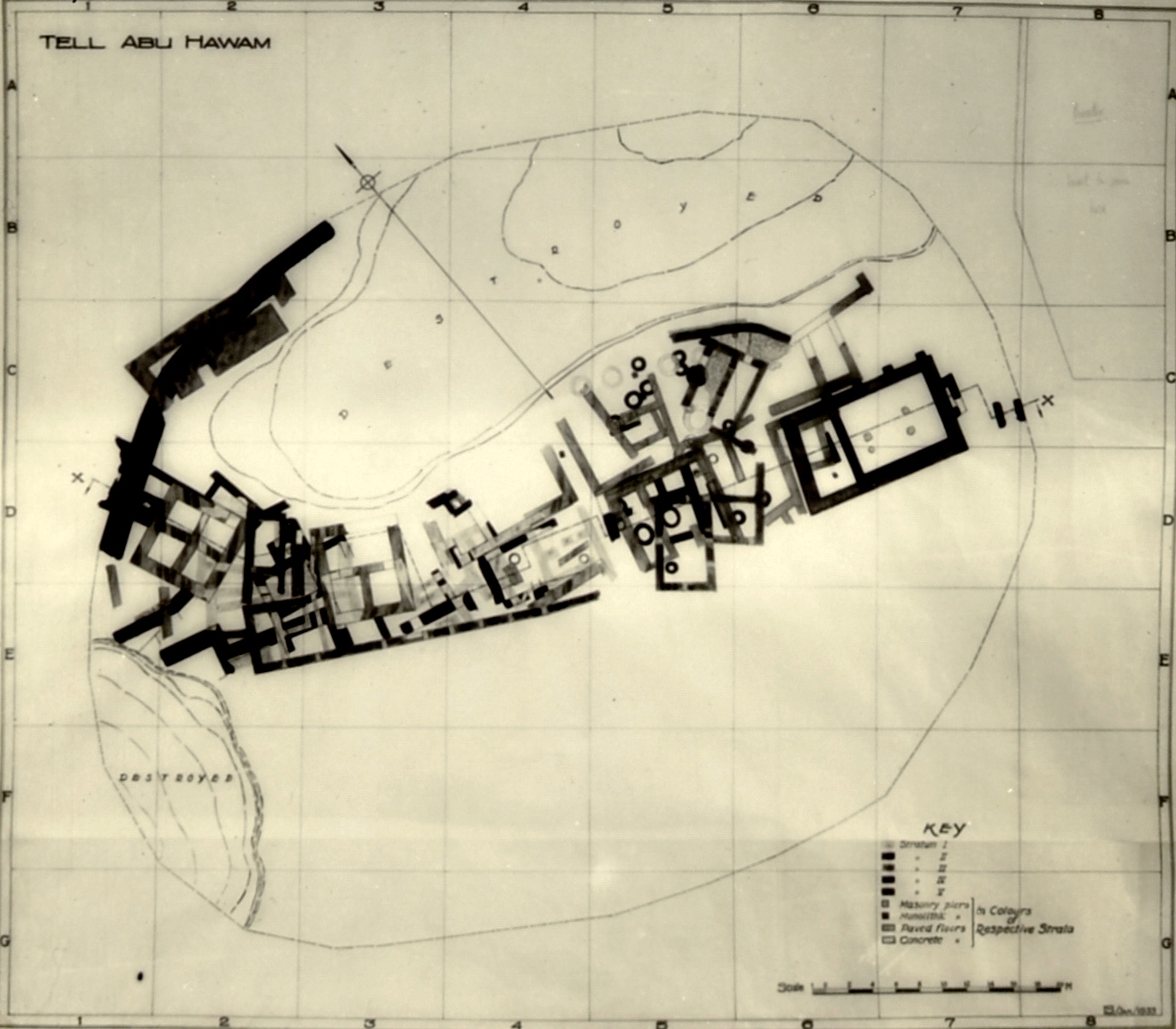
- Fig. 6 Location of main
architectural remains on the Tel from Balensi et. al. (1985a)
Fig. 6
Tel Abu Hawam. Location of main architectural remains on the Tel
- Bastion, Level III, Iron Age (I-) II
- Level V Wall, Late Bronze
- Bastion 67, level V, Late Bronze
- Level III Wall, Iron II
- Citadel of Level V, Late Bronze
- House 61 (Syro-Hittite), Level V-IV, Iron I
- Level II Wall, Persian period
- Level III period
- Level V Wall, Late Bronze
- Gate of the city of the Late Bronze
- Buttress wall, level V, Middle or Late Bronze
- Repair of the wall of level V, Late Bronze-Iron I
- Casemate, cf. Num. 11
- Level V Temple, Late Bronze
- Level II Wall, Persian period
- Double wall of the Bronze or Iron Age
- Presumed port
Balensi et. al. (1985a) - Fig. 11 Axonometric view of the
western section of the Tel from Balensi et. al. (1985a)
Fig. 11
Axonometric view of the western section of the tell.
Balensi et. al. (1985a) - Fig. 8 Cross-section - Guide
to Stratigraphy of the Tel from Balensi et. al. (1985a) (modified from Hamilton, 1935)
Fig. 8
Tel Abu Hawam. Guide to reading the stratigraphic section of the tell published by RW Hamilton (cf. QDAP, III, 1934, pl. XIX = QDAP, W, 1935, facing p. 1).
Balensi et. al. (1985a) - Plan of the Tell with
location of cross-section (ɸ) from Hamilton (1935)
JW: Plan of the Tell with location of cross-section
Hamilton (1935) - Pl. IV Plan of Stratum IV
from Hamilton (1935)
Plate IV
Plan of Stratum IV
Hamilton (1935) - Fig. 3 Plan of Stratum IV
from Vincent (1935)
Fig. 3
Tell Abu Hawam. - The city II Level IV from QDAP, III, 1934, pl. xix.
Vincent (1935)
- Fig. 2
Tectonics of Haifa Bay from Balensi et. al. (1985a)
Fig. 2
Diagram of the main tectonic movements affecting Haifa Bay
Balensi et. al. (1985a) - Fig. 4
Topography of Tel Abu Hawam in 1963 from Balensi et. al. (1985a)
Fig. 4
Topographic survey of Tel Abu Hawam, contemporary with the 1963
excavations (IEC and IDAM) Balensi et. al. (1985a) - Fig. 5
Location Map of Excavations and Surveys (1929-19840 on the Tel from Balensi et. al. (1985a)
Fig. 5
Location Map of Excavations and Surveys on the Tel
excavations (IEC and IDAM) Balensi et. al. (1985a) - Fig. 6
Location of main architectural remains on the Tel from Balensi et. al. (1985a)
Fig. 6
Tel Abu Hawam. Location of main architectural remains on the Tel
- Bastion, Level III, Iron Age (I-) II
- Level V Wall, Late Bronze
- Bastion 67, level V, Late Bronze
- Level III Wall, Iron II
- Citadel of Level V, Late Bronze
- House 61 (Syro-Hittite), Level V-IV, Iron I
- Level II Wall, Persian period
- Level III period
- Level V Wall, Late Bronze
- Gate of the city of the Late Bronze
- Buttress wall, level V, Middle or Late Bronze
- Repair of the wall of level V, Late Bronze-Iron I
- Casemate, cf. Num. 11
- Level V Temple, Late Bronze
- Level II Wall, Persian period
- Double wall of the Bronze or Iron Age
- Presumed port
Balensi et. al. (1985a) - Fig. 8
Cross-section - Guide to Stratigraphy of the Tel (by Hamilton) from Balensi et. al. (1985a) (modified from Hamilton, 1935)
Fig. 8
Tel Abu Hawam. Guide to reading the stratigraphic section of the tell published by RW Hamilton (cf. QDAP, III, 1934, pl. XIX = QDAP, W, 1935, facing p. 1).
Balensi et. al. (1985a) - Plan of the Tell with
location of cross-section (ɸ) from Hamilton (1935)
JW: Plan of the Tell with location of cross-section
Hamilton (1935) - Fig. 11
Axonometric view of the western section of the Tel from Balensi et. al. (1985a)
Fig. 11
Axonometric view of the western section of the tell.
Balensi et. al. (1985a) - Fig. 17
Location Map from Balensi et. al. (1985a)
Fig. 17
Tel Abu Hawam. Was the eastern cemetery in use as a regional necropolis at the end of the 2nd millenium B.C. ?
Balensi et. al. (1985a) - Fig. 18
Triptych of the Tel and environs from Balensi et. al. (1985a)
Fig. 18
Tel Abu Hawam. Triptych uniting the Tel (Fig. 6), the Kishon Delta, and the necropolises (p.120)
- Bastion 67 of level V, facing the mouth of Wadi Salman
- Level V
- Rampart paving located in the extension of Bastion 67, but outside the rampart
- Bank of Wadi Salaman
- Late Bronze Age individual burials, dug in the sand and well preserved
- Tombs eroded by floods and undated (The most numerous)
- Multiple Burial Caves of Iron II
Balensi et. al. (1985a) - Architecture and
Stratigraphy of Stratum III from Balensi et. al. (1985a)
Architecture and Stratigraphy of Stratum III by M.-D. H.
Balensi et. al. (1985a)
3. — EXCAVATIONS OF 1932-1933.
Two campaigns, led by R.W. Hamilton, provided results that made the site famous thanks
to the publication of excavation reports that were exemplary in terms of the speed of
their publication and the concise and structured nature of their presentation. No doubt
it should be remembered that the references provided by Meggido, Tell Beit Mirsim, etc.,
were still to come, as well as the main synthesis studies on Cypriot and Aegean productions.
Many more or less constructive comments gradually came to expand the bibliography of
Tell Abou Hawam. These contributions attest that, for half a century, the site has
been the subject of increasing speculation in terms of chronology, trade and cultural
influences, among specialists dealing with the Eastern Mediterranean between the end of
the Middle Bronze and the Hellenistic period. The contribution of “new” data from old
excavations can therefore only receive a favorable welcome since it stimulates international research.
The available sources of information have already been mentioned in the 1982 report.
According to the numerous photographs, the limits of the excavations appear to have been,
to within a few tens of centimeters, those of the peripheral structures presented on the plans
published in 1935 (Fig. 5; pl. V, b).
It must be emphasized here that
- during his first campaign, the excavator explored as quickly as possible the northern half of what apparently remained of the tell after the earlier destructions
- that the discovery of the material associated with the superimposed temples 30 and 50 (part of the parallels of which are only found on the most prestigious sites: Our, Assour, Mari, Râs Shamra, Rhodes, Enkomi..., cf. fig. 1)9 meant that the importance of the site - small, destroyed and without any attraction - could no longer escape the authorities
- that careful attention was therefore paid to the stratigraphy during the second campaign, devoted to the southern half of the tell
- that the recording system then developed on site is different and more accurate than that subsequently published
- that the conclusions that can be drawn from this site stratigraphy are chronologically consistent
- that the chrono-stratigraphic corrections which have already been proposed (1982 report) concerning levels IV and V, therefore directly reflect the observations made in the field by Hamilton.
Balensi et. al. (1985a)
It must therefore be understood that the sequence of levels I to V proposed by the excavator in his publication is a synthetic interpretation and, as such, revisable. That said, it would be premature to provide replacement terminology here, as too many questions still remain unanswered, in particular those related to the history of the fortifications.
3C1. — Stratigraphy.
R.W. Hamilton presents stratum III as a level clearly limited by two layers of fire: based on the
layer that seals the destruction of stratum IV, stratum III is itself sealed by a burnt layer;
Then comes a notable period of abandonment which precedes the installation of stratum II.
According to the published plan (see QDAP, IV, 1935, pl. III), this level III consists of a fairly
dense set of adjoining rooms (no.s 13 to 24 and 27), as well as isolated buildings (no.s 11, 12, 25, 26).
In his first report, the excavator specifies that this stratum sometimes reaches a thickness of 2 m
and indicates more than one phase of construction, but without detailing further; in his second
report, he speaks soberly of the areas disturbed by later occupations and condenses rooms 13 to 21
under the name of “Period III” because of their architectural unity. In addition, the city had an
enclosure wall of which some foundation courses remain to the south-west, to which would have
been attached a narrower section of wall and a "bastion" to the north-west. The whole,
without phase distinction, is dated by Hamilton to “1100-925 (?) B.C.”.
While it is only a question of a single layer of fire separating strata IV and III, the published
stratigraphic section (cf. fig. 8) shows at least two, clearly separated in time, although
practically confused: in chronological order, a first layer of ashes seals all or part of
houses 44 and 45, passing under house 36, also assigned to level IV; a second layer thickens
the first above Building 44, but separates farther east to seal House 3611.
- Plan of the
Tell with location of cross-section (ɸ) below from Hamilton (1935)
JW: Plan of the Tell with location of cross-section
Hamilton (1935)
Fig. 8Tel Abu Hawam. Guide to reading the stratigraphic section of the tell published by RW Hamilton (cf. QDAP, III, 1934, pl. XIX = QDAP, W, 1935, facing p. 1).
Balensi et. al. (1985a)
During the lapse of time between these two fires — to be clearly distinguished — several structures of stratum III were built12. On the second layer of ash, towards the center of the tell, other level III structures then appear there13. Further to the east and still visible on the section, other ashy layers are superimposed, suggesting even later fires, but which occurred before the end of stratum III.
The organization of all the phases that could be distinguished within level III as published in 1935, can be done with a sufficient degree of certainty, on the one hand by considering the relationships between the layers of destruction and the associated buildings, and on the other hand by detecting the architectural incompatibilities between the structures recorded by the excavator.
Architecture and Stratigraphy of Stratum III by M.-D. H.Balensi et. al. (1985a)
3C2. — Architecture and stratigraphy.
It is the meticulous study of the architectural remains of squares DE, 3-4 which serves as the basis for the reasoning14. Schematized in an attached table, the results of the analysis show at least six definite phases of construction. It is undoubtedly necessary to underline the pivotal role played by building 27, which came under level IV on the site as in Hamilton's preliminary report and was then reassigned to level III in its final report15. Room 25 was partially reused during the reoccupation of the places corresponding to stratum II.
Pieces 13 to 21 constituting “Period III” form a set with no evidence that could suggest several independent phases of construction; this set is however not homogeneous because most of the walls have been reused, which implies a minimum of two phases of occupation. This “period”, shorter than stratum III, cannot be identified with it; but its exact stratigraphic position in the sequence is difficult to establish due to insufficient information. A number of clues, however, allow us to conceive that this island is after the construction of building 27 and that the use of rooms 18 to 20, at least, ceased before the end of level III16.
With regard to the fortifications located in the northwest quarter of the tell, Hamilton's final report suggests that the bent rampart of squares D-E, 1 (better preserved in its northern part and built in a jagged pattern towards the south) has had to be connected to the large bastion of square C2 (fig. 6.) These structures were known from the first campaign of excavations and the preliminary report proposed another interpretation; the bastion and the southern section of this surrounding wall belonged to level IV, while the central part was not distinct from level V. The impression prevails that, during the second campaign, the excavator having found the rampart of stratum III to the southwest and not having identified a defensive system specific to stratum IV, reluctantly reinterpreted all these elements as belonging to level III17.
The reattribution of the bastion was justified by the pottery — which has remained unpublished — which was associated with it18: the only fragment found which is in fact useful19 is a shard of a plate with red engobe of the so-called type "from Samaria" (fig. 9, n° 8); however, it was collected in the corridor which separates the platform from the outer wall in the shape of a horseshoe; it cannot therefore suffice to date the construction of this set which has never been dismantled by Hamilton or by Anati (excavations of 1963). Being isolated from the other structures of level III, this bastion cannot be attached to any of the architectural phases shown schematically in the attached table. Only an excavation of the preserved parts could confirm that it does not belong to level IV...
3C4. — Chronology.
The presence of this shard from the Geometric period puts the date of the end of level III until the
middle of the eighth century at the earliest. The material briefly mentioned above falls well
within a chronological gap extending from the beginning of the tenth century to the years 750
and perhaps even 700. The two main periods known for the evolution of Phoenician ceramics41
are clearly represented in stratum III from Tell Abu Hawam, which finds excellent parallels in Tyre
(str. II to XII), Sarepta (str. C and D), Keisan (levels 5 to 8), Megiddo V A-IV B,
Qasile IX, etc. Certain absences can be significant: the torpedo jars and the plates with
rims or spread lips which characterize the Keisan level IV (700-650)42; or even the
bobèche jugs with a glossy red engobe that appear in Tyre II - III (760-700) could serve as
a reference to characterize the end of Hamilton's stratum III.43
Balensi et. al. (1985a)
Two fundamental points emerge from the preceding lines: on the one hand, all the architectural remains and ceramics fit perfectly into a Phoenician context; on the other hand, the above chronologies can no longer be maintained once unpublished material is taken into consideration. It is legitimate to recall here the intuition of Father Vincent o.p. who, from 193544, sensed both the necessarily Phoenician character of the site, as well as the historical probability of an occupation of the place at least until the Assyrian conquest, if not later!
It finally turns out that, in the history of research, Tell Abu Hawam served, a few decades ago, to date approximately the beginning of the Geometric period in Greece. Today, it is this Aegean chronology that helps it find its place in the ancient history of the Mediterranean Near East. The revision of the documentation kept by RW Hamilton is also fully justified here.
GENERAL RESULTS
-
Traces of occupation going back to the Middle Bronze II period
are attested by a few finds, not properly stratified in Hamilton's Stratum V.5
None of this material is stylistically later than Megiddo X or Beth-shan X—XA; if it is all
from a single period, a date around 1600 B.C. should be considered (fig. 1).
Since no structure is necessarily to be assigned to MB, it is premature to speak yet of the foundation of the site. It would seem logical, however, keeping in mind the increasing density of strategic settlements in the "Hyksos" period, as at Tel Mor (Dothan 1973), to assign the base level to MB IIB—C. -
Five horizons can be isolated within the Late Bronze period, separated by violent destructions.
They all belong to Stratum V (the last horizon is the first stage of Hamilton's Phase Vb).
They reflect, successively
- Megiddo IX (believed to have been destroyed by Thutmosis III6)
- Megiddo VIII (2 periods: Amenophis III7 and El Amarna8)
- Megiddo VIIb (2 periods, contemporary with the Egyptian 19th Dynasty).9
Clearly, Cypriot and Canaanite finds coexist prior to any identified Aegean remains. The Cypriot corpus comprises about 200 items, of which about 90 percent are unpublished; they range from the end of the Late Cypriot IA to IIC periods, and include not only small finds such as figurines, a cylinder seal, and statuettes (fig. 2), but also a wide repertoire of ceramic wares and shapes10 that indicate the relations with the coast south and east of the island.
Even compared to large cities like Enkomi and Ugarit with rich cemeteries, Tell Abu Hawam is an outstanding site with its collection of over 700 Aegean imports. Although still unconfirmed, the presence of material earlier than Late Minoan and Mycenaean IIIA2e (contemporary with Amenophis III) and later than IIIB (i.e., the 19th Dynasty) cannot be ruled out. The bulk of the collection consists of Mycenaean IIIA2b (El Amarna period and, possibly, the end of the 18th Dynasty) and Mycenaean IIIB; by then, statistics show that imports more than doubled. In the earlier period, the available repertoire is roughly similar to that of El Amarna and Mycenae; in the latter, it has become larger than at Mycenae itself, owing to the Levanto-Mycenaean production. However, the quantity of figure patterns remained constant during the 14th and 13th centuries, accompanied by a growing tendency toward linear decoration.11 In Cyprus and the Near East, it is normal to find more closed shapes than open ones; at Tell Abu Hawam, the proportion is well balanced during the Mycenaean IIIB and possibly also the IIIA2b periods. As elsewhere, the stirrup jar dominates the market, but it is still not as common at the site as drinking vessels on the whole, i.e., cups plus kylikes and chalices. The relative frequency of shapes is quite different from that of Cyprus, but very close to what has been found in the Aegean.12 Neutron activation analysis has attested to specific trade connections between Tell Abu Hawam and the Argolid (Perlman 1973: 215).
Three arguments, possibly convergent, may contribute to a better understanding of these unusual features. One was well formulated already by Hankey (1967: 146): "Cypriote importers took the cream of the supply since it reached them first (and they had copper to trade back), and the Middle East in general got the left-overs." But most of the available repertoire from the site fits local needs perfectly, with similar shapes in much finer quality, thus giving root to the idea of complementarity. The only exception would be the shallow cup: fragments of more than 100 such items were scattered all over the site. They may be a sign, although not a decisive one, of some Mycenaean presence.
The history of the LB fortifications is not altogether clear. The long wall with inner salients, undated previously (Gershuni 1981: 37), is now known to have been out of use from the El Amarna period onward (at least in its eastern section). Thus the settlement was provided with a city wall possibly at the time of Amenophis III at the latest, or, more likely, during the maritime policy of Thutmosis III and IV in the 15th century B.C. — if not even earlier (below).
As far as the cyclopean fortifications are concerned, they may antedate the 19th Dynasty and be simply reused in the 14-13th centuries. Complex 66, which rests partly on and encompasses the eastern half of the citadel, has a system of latrines known also in the Ashlar Building, along with a megaron, at Enkomi IIIa (Dikaios 1969, I: 178; III: 273-75; French 1980: 268). Thus this complex is able in itself to offer some kind of Aegean architectural context for the amazing frequency of Mycenaean III imports discovered in this sector.13 Furthermore, there are striking similarities between the citadel of Tell Abu Hawam and the West Building at Tacanach, redated to MB IIC by Lapp (1964: 15).14 Whatever the period of construction may have been, the fortifications may have been a Canaanite tradition; and the possibility of Egyptian influence in the background cannot be excluded (contra Weinstein, 1980).15 Analysis of Anati's soundings, now in progress, should contribute to the solution of this problem. - Attention should be paid to the question of the transition between the Late Bronze and Iron Age periods. No material attributed to Stratum V in the field is later than ca. 1200 B.C.,16 although Stratum V in Hamilton's report includes 11th century B.C. ceramics and small finds.17 That is, the gap in occupation, proposed by Mazar — if any at all -18 is to be looked for within Phase Vb of the preliminary reports, not between Strata V and IV (Maisler 1951: 25; Anati 1975: 12), or between Phases IVa and IVb (Van Beek 1955: 38, n. 15; Wright 1961: 97; Gershuni 1981: 44).
-
Iron I comprises five distinct periods of construction divided between Phases Vb19 and IVa-b
of the preliminary reports. They include an attempted fortification wall at 61-63 and temple 30.20
The domestic structures reflect clearly the arrival of a new population, coming probably from northern Syria21
at the time or soon after the appearance of the Phoenician bichrome ware. The proper historical context for
such a movement, around 1100 B.C., is the war of Tiglath Pileser I of Assyria against the Arameans.
A violent fire put to an end the period of isolated T-partitioned square houses sometime in the mid-11th century.22
Following the same plan, organized rebuilding took place in the southwest quarter of the mound; it shows the same tradition of wall construction, with a row of small stones alternating with two larger ones. This technique still appears in the next stage of construction, in what is probably the "manor house" of a small village.23
Thereafter the structures are normally characterized by the Phoenician pillared technique (Elayi 1980: 165), as first attested in the so-called store galleries of Phase IVb. This occupation illustrates the appearance, as yet unpublished, of the black on red style (Room 31), in connection with the usual bichrome ware (continuously represented since Phase Vb). By then the material culture is similar to that of Qasile X; both destructions, ca. 1000 B.c., may have had the same — possibly Davidic — origin. -
Iron IIA is represented essentially by Stratum III. But 10th century finds (i.e., later than the horizon
at the southwest quarter and at the burnt galleries of Phase IVb) are already part of field
Stratum IV; the latter included remains of occupation earlier than Stratum III fortifications
and Hamilton's "Period III" (that is Rooms 13-21). The key is Building 27, described as a
connecting link between Strata IV and III. This building had been planned in direct relation
with its predecessor to the south, Mansion 3-32 of Phase IVb, i.e., prior to Period III.
Since it was somehow neglected in previous studies, the lack of stratigraphical homogeneity within Stratum III must be underlined here.24 This basic feature is of utmost importance, because for nearly half a century the chronology of the early Geometric period in Greece has rested on two published Aegean imports found at Tell Abu Hawam (Coldstream 1968: 302-10). -
Iron II is characterized by a complex sequence, still under careful study by D. Herrera.
It should be enough to say that occupation is attested until at least the 8th century B.C.
What can be deduced from the existence of late Samaria ware (as described by Hamilton for Rooms 13-14)25
is confirmed by unpublished data, e.g., an Aegean import that stylistically is not earlier than the
Dipylon in Athens, ca. 750 B.C. (fig. 3).
Through the wide repertoire of local and foreign finds, it has become clear that the city was quite active, not only in the latter part of the reign of Solomon, but also during the whole of the Divided Monarchy. However, the absence of a casemate rampart or of any four-roomed houses makes it likely that Tell Abu Hawam was Phoenician rather than Israelite.
- What happened during Iron Age IIC, i.e., in the Neo-Assyrian and the Neo-Babylonian periods? Possibly there was a gap in occupation, but it was certainly shorter than was previously thought. Further work is still required before any valid conclusions can be drawn.26
- As regard the Persian period, none of the poor architectural remains of Phase IIa can be properly dated. But Greek imports ranging from the 6th to the 5th centuries B.c. have been found below the rebuilt and fortified city of Phase IIb. Stern (1968) has also stressed the lack of Alexandrian coins in the hoard linked to Phase IIb, suggesting a destruction at the eve of the Hellenistic period. Since unpublished data, including more Greek imports, are available from Hamilton's and Baramki's excavations,27 a systematic check must be made to give an overall view of these periods (fig. 4) and those later still.
5 Generally scattered over the area or somewhat concentrated near Well 56 were MB
fragments from a piriform juglet with button base, a red burnished dipper juglet,
a red-on-black Cypriot bowl, and - possibly the scarab (Hamilton 1935: no. 402)
illustrated in fig. 1.
6 Fragmentary chocolate-on-white bowls, Cypriot base ring I trefoil juglets,
bichrome kraters, etc., were spread mainly along an east-west axis, from
Temple 50 to the Citadel via the square E5 Well at Locus 56, and at low
levels in Locus 67 to the north.
7 The same pattern of occupation is attested through unrestorable Late
Minoan and Mycenaean IIIA:2e vessels, most of which are burnt. Also damaged
by fire are the published group no. 263 et al., found west of Locus 56;
they may belong to the previous Thutmosis III horizon, or to the reign of
Amenophis III at the latest. Not earlier than the second half of the
15th century B.C. is the Cypriot flat-based, large Milk Bowl, no. 31Od;
it was discovered (with unpublished local painted fragments of domestic
jars and biconical vessels) by the tabun in square D5, under the interior of
Building 52 (which is incorrectly interpreted by Gershuni 1981).
8 The early house in Locus 59 and the architectural remains immediately
east of it show the highest concentration of Mycenaean IIIA:2b imports,
plus signs of the transition into Late Minoan IIIB and Mycenaean IIIB: I.
Similar features appear in Temple 50 (before the destruction by fire
of its west porch), where quantities of Mycenaean IIIA:2b are smaller than
those, in diminishing order, at Locus 67-66 to the northwest, in
Square E3 and EF3 (Citadel sector) and around Well 56 (i.e., north of Complex 59).
9 These horizons are characterized by an overwhelming quantity of
Mycenaean IIIB, generally fragmentary and stratigraphically
contemporary with Cypriot and Egyptian imports. A violent destruction
by fire happened after the appearance of Mycenaean IIIB:2 and
the Cypriot Rude Style. All sectors of the tell were touched,
including those of the Citadel and Temple 50 (now provided with
the four column bases and a central stone-lined pit). In both places,
as well as to the south (Complex 59-60), reoccupation is attested by
unburnt, stylistically later imports, comprising the Gray "Minyan"
ware (Troy VI/VII: its earlier occurrence cannot be proven); they were
still in use at the time of sporadic fires like those in Loci 51 and
upper 58. The construction of the latter shows that Well 56 in
Square E5 was no longer in use; it seems to have been replaced
by the well south of Locus 52 in Square D5 (9.65-6.75), which
yielded only burnt fragments, all of them Mycenaean IIIB but
for one local LB IIB painted krater.
10 Apart from the red-on-black ware already mentioned (n. 5),
the following Cypriot wares have been identified: black slip,
bichrome (wheelmade), monochrome, pseudo-monochrome (ladles),
base ring I (thin ware and thick ware), base ring II (hand and
wheel made), white slip I, IIA, II and "III," white shaved
(including jug no. 229), coarse (wall brackets, cooking pot no. 238),
plain white wheelmade I, pithos ware, white painted V, white painted
wheelmade II, and, more recently, handmade bucchero. Eight
zoomorphic pots and statuettes (no. 286 [fig. 2], 302-305,
plus three unpublished) and the fragments of three female
figurines (no. 319-321) illustrate the typical Late Cypriot II
repertoire (Catling 1976; V. Karageorghis 1978; J. Karageorghis 1977: 75, 83);
all of them are related to base ring ware. The study of the large Cypriot
corpus has benefited from the advice of R. S. Merillees, E. Oren, and
M. Yon-Calvet, to whom the author wishes to express thanks.
11 Without the comprehensive experience of V. Hankey, assisted by E. French,
the analysis of the Aegean corpus would have never reached its present stage; the author
is much indebted to both of them for their most generous contributions. In the more
than 700 items from Hamilton's excavations at Tell Abu Hawam, over 500 can be classified
typologically, and 160 are decorated with identifiable patterns, following Furumark's
principles (1941) and E. French's up-to-date contributions for the Argolid. On the
horizon of Mycenaean IIIA:2b, Tell Abu Hawam offers a range of 21-25 shapes (FS) and
22 motifs (FM); 25 FS and 30 FM were identified by French at Mycenae, while 22 FS and
18-23 FM were noted by Hankey at El Amarna (1973: 129). On the Mycenaean IIIB horizon,
French has registered 22 FS and ca. 30 FM, while the presently available TAH corpus
offers 25-35 FS and 22-23 FM.
12 Comparative data for the Mycenaean ceramic forms are tabulated below (cf. Astrom 1973: 125)
Comparative data for the Mycenaean ceramic formsBalensi (1985b)
13 Nearly half of the large Mycenaean IIIB collection was found in the western third of the tell, extending over Loci 63 to 68. But in no way are the Citadel and Complex 66 specifically identified in the field code. The objects are simply labelled as having been found below the houses of Phase Va; even Mycenaean IIIA:2b is represented at the foundation and floor levels of Houses 44 and 45, that is to say, much too high above the remains of the Citadel, compared to the rather good state of preservation of the later latrine complex at Locus 66 (see the sole published stratigraphical section in Hamilton 1934, 1935).
14 Noted similarities are: orientation, mezzi building stone from Mt. Carmel, thickness of walls, type of plan, proportions of layout (3/3 for Ta'anach and 4/3 for Tell Abu Hawam).
15 Compared to Megiddo and Beth-shan, the lack of impressive remains at Tell Abu Hawam is particularly striking - if it was really an Egyptian naval base as suggested by Mazar (1951), a hypothesis contradicted by Weinstein 1980. But in any case, some kind of Egyptian presence in the vicinity has to be presumed:
- From an architectural point of view, Temple 50 is evocative of some Egyptian chapels like that at El Kab (Vandier 1955: 840, fig. 405), although this is not decisive. More interesting are the similarities between the early house in Locus 59 and contemporary domestic units in the worker's village at El Amarna. They are both built on a rectangular base (5 x 1O m, with 0.6 m thick walls), i.e., a tripartite plan with two backrooms (Peet and Woolley 1923: 55, pl. 16).
- More 18th and 19th Dynasty finds have been identified during the revision process, including ceramics (hemispherical red bowls, date-shaped jars, etc.); possibly two of them belong to the earliest field phase of occupation.
- One must keep in mind the state of destruction of the site (including the sector of the Citadel) prior to Hamilton's excavations, as well as the fact that objects were known to be already on the antiquities market in Haifa.
- Obviously the economic factor must not be dissociated from the strategic location of the mound. The logical assumption is that it was in Egyptian interests to support the security of the place through some kind of military presence in the immediate vicinity. Akko may have been the major naval base, with Tell Abu Hawam as the commercial harbor.
- The presumed occupational gap in the 12th century is odd (n. 18). Should not Ramses III have settled a group of the "Sea Peoples" to ensure lasting Egyptian control?
16 This includes Late Minoan UIB matte-surfaced "oatmeal" ware and a cup in zigzag heavy style with monochrome inside; Mycenean IIIB:2 small deep bowls (FS 284B); Cypriot rude style kraters; and gray Trojan ware, often known as "Minyan."
17 Phoenician bichrome jugs, no. 249 and 250 from the room north of Locus 56, et al., published group no. 244 from below and on the pavement in Building 55 (with a T-shaped partition wall); jug no. 251 from above the pavement level in Building 53; Aegean glass spiral pinheads no. 394c from Temple 30 (L. Astrom 1972: 597, n. 6 Late Cypriot IIIB).
18 A 12th century gap in occupation seems to be reflected by the apparent lack of imported Mycenean IIIC (including the early linear style), Cypriot bucchero wheelmade and proto white painted wares, and local Mycenaean IIIC and Philistine productions. However, no definite answer can be given as long as the whole available corpus from Tell Abu Hawam has not been checked (see n. 3).
19 The first known period unites Building 55 (the remains at Locus 54-55 W. could well be 12th century), the room north of Locus 56, the upper remains in Locus 52, the walls northeast of 3- Vb (belonging to field Stratum IV), and Temple 30. Iron Age ceramics were found already below the above-mentioned Loci 55 and 56 N (which were also part of field Stratum IV). The second period witnesses the appearance of the long wall south of Locus 52, leaning against the inner west wall of Temple 30 and Houses 61, 62, and Locus 53.
20 The material associated with the so-called "floor of Temple 30" is late LB IIB, including imports. It comes from a layer of hard earth and ashes, mixed with sand, identified by the excavator as a filling by the foot of the standing pillar (Hamilton 1934: 76/77). Such a layer can be traced through the published section and field photographs, below the walls of Temple 30; thus these objects are necessarily earlier than this structure and correspond to the last reoccupation in Temple 50.
On the other hand, the plan and orientation of Temple 30 are similar to those of the Northern Temple (dedicated to 'Anat) at Beth-shan in Stratum V Lower (i.e., 10th century B.C.). This level has produced a SyroPalestinian statuette of the same type as Hamilton's no. 370 (Negbi 1976: 46, no. 1447, 1448). A movement of cultic influence southward sometime during the transitional period between that Late Bronze and the Iron Age can be presumed from the fact that this type of idol, not known in ancient Syria after the 12th century B.C., does appear around this time and afterward in coastal and central Palestine (Negbi 1976).
Whether the gold leaf-coated bronze statuette from Tell Abu Hawam belongs to Temple 50 or 30 cannot be stratigraphically determined. In the former case, it would tend to link the site to the north Canaanite culture as at Ugarit in the 14th-13th centuries; in the latter case, it would underline the lack of Israelite orthodoxy at the site (cf. 2 Kgs 3:2; 10:26; Ex 23:24;34:13).
21 The origin of this type of structure lies in the Fertile Crescent, as can be seen in architecture characteristic of Meskene-Emar in the Euphrates Valley, during the 14th-13th centuries B.C., a Hittite foundation with parallels from Anatolia at Boghaz Koy (Margueron 1980: 285); but the real prototype is as early as the third millennium, as seen at Tell Asmar-Eshnunna in southern Mesopotamia (Delougaz et al. 1967: pl. 27:30).
Though rare, the square house with a T-shaped partition wall is not totally unknown in Palestine. The MB II "Patrician House" at Tell Beit Mirsim (Stratum D) shows affinities with Chagar Bazar in the Habur region, according to Albright (1938: 36, 37, nn. 19-20). The domestic quarter, facing the Syro-Hittite Stelae Temple in the lower city at Hazor, presents the same features in LB II (T. Dothan in Yadin et al. 1960: 98, pl. 208: 6061). A much later occurrence is known at the oasis of 'En-gedi during the Neo-Babylonian Period. The four-room "Israelite" house (Shiloh 1970) may be derived partly from the north Syrian tradition.
22 The third period of Iron Age I constructions is represented in the northwest by Houses 44 and 45. sealed by a layer of ashes that is shown on the published section to reach the foundation level of House 36 in the southwest quarter. Thus Phase IVa is not homogeneous; Hamilton's description fails to distinguish the upper and lower ash layers covering House 44 (see n. 24).
23 The fourth period is composed of Houses 36, 37, 40-43. The main ceramic features from there are similar and sometimes identical to those of the later Galleries 33-35, suggesting a similar or identical date. The fifth period of construction is that of Building 3-32, against the south wall of which lay the storerooms. No material associated with Structures 38-39 has yet been identified.
24 The upper layer of ash covering Stratum IV Houses 44 and 36 (see n. 2l) belongs to Stratum Ill and divides it in two distinct phases of occupation. In each of these, several discontinuous periods of construction can be traced.
25 The preserved sherds illustrate Types 6 and 7 of Bikai's "Fine Ware Plates" (1978: 28-29); the former is not earlier than Stratum V at Tyre, dated to the second quarter of the 8th century B.C.
26 Since some of the available repertoire from Tell Abu Hawam has parallels in the stratified sequence at Tell Keisan (niveaux 5-4), the Stratum III occupation under investigation may have lasted until around 650 B.C. Keisan presents, then, a gap of about a century (i.e., the Neo-Babylonian period), followed by a renewal sometime during the Persian period (Humbert 1981: 382-85). Since the two sites are only 15 km apart, they may have undergone similar evolution.
27 There are 138 items on the 1930 excavation registration book. This material is stored at the Rockefeller Museum in Jerusalem.
- Fig. 6 Location of main
architectural remains on the Tel from Balensi et. al. (1985a)
Fig. 6
Tel Abu Hawam. Location of main architectural remains on the Tel
- Bastion, Level III, Iron Age (I-) II
- Level V Wall, Late Bronze
- Bastion 67, level V, Late Bronze
- Level III Wall, Iron II
- Citadel of Level V, Late Bronze
- House 61 (Syro-Hittite), Level V-IV, Iron I
- Level II Wall, Persian period
- Level III period
- Level V Wall, Late Bronze
- Gate of the city of the Late Bronze
- Buttress wall, level V, Middle or Late Bronze
- Repair of the wall of level V, Late Bronze-Iron I
- Casemate, cf. Num. 11
- Level V Temple, Late Bronze
- Level II Wall, Persian period
- Double wall of the Bronze or Iron Age
- Presumed port
Balensi et. al. (1985a) - Fig. 11 Axonometric view of the
western section of the Tel from Balensi et. al. (1985a)
Fig. 11
Axonometric view of the western section of the tell.
Balensi et. al. (1985a) - Fig. 8 Cross-section - Guide
to Stratigraphy of the Tel from Balensi et. al. (1985a) (modified from Hamilton, 1935)
Fig. 8
Tel Abu Hawam. Guide to reading the stratigraphic section of the tell published by RW Hamilton (cf. QDAP, III, 1934, pl. XIX = QDAP, W, 1935, facing p. 1).
Balensi et. al. (1985a) - Plan of the Tell with
location of cross-section (ɸ) from Hamilton (1935)
JW: Plan of the Tell with location of cross-section
Hamilton (1935) - Pl. III Plan of Stratum III
from Hamilton (1935)
Plate III
Plan of Stratum III
Hamilton (1935)
- Fig. 2
Tectonics of Haifa Bay from Balensi et. al. (1985a)
Fig. 2
Diagram of the main tectonic movements affecting Haifa Bay
Balensi et. al. (1985a) - Fig. 4
Topography of Tel Abu Hawam in 1963 from Balensi et. al. (1985a)
Fig. 4
Topographic survey of Tel Abu Hawam, contemporary with the 1963
excavations (IEC and IDAM) Balensi et. al. (1985a) - Fig. 5
Location Map of Excavations and Surveys (1929-19840 on the Tel from Balensi et. al. (1985a)
Fig. 5
Location Map of Excavations and Surveys on the Tel
excavations (IEC and IDAM) Balensi et. al. (1985a) - Fig. 6
Location of main architectural remains on the Tel from Balensi et. al. (1985a)
Fig. 6
Tel Abu Hawam. Location of main architectural remains on the Tel
- Bastion, Level III, Iron Age (I-) II
- Level V Wall, Late Bronze
- Bastion 67, level V, Late Bronze
- Level III Wall, Iron II
- Citadel of Level V, Late Bronze
- House 61 (Syro-Hittite), Level V-IV, Iron I
- Level II Wall, Persian period
- Level III period
- Level V Wall, Late Bronze
- Gate of the city of the Late Bronze
- Buttress wall, level V, Middle or Late Bronze
- Repair of the wall of level V, Late Bronze-Iron I
- Casemate, cf. Num. 11
- Level V Temple, Late Bronze
- Level II Wall, Persian period
- Double wall of the Bronze or Iron Age
- Presumed port
Balensi et. al. (1985a) - Fig. 8
Cross-section - Guide to Stratigraphy of the Tel (by Hamilton) from Balensi et. al. (1985a) (modified from Hamilton, 1935)
Fig. 8
Tel Abu Hawam. Guide to reading the stratigraphic section of the tell published by RW Hamilton (cf. QDAP, III, 1934, pl. XIX = QDAP, W, 1935, facing p. 1).
Balensi et. al. (1985a) - Plan of the Tell with
location of cross-section (ɸ) from Hamilton (1935)
JW: Plan of the Tell with location of cross-section
Hamilton (1935) - Fig. 11
Axonometric view of the western section of the Tel from Balensi et. al. (1985a)
Fig. 11
Axonometric view of the western section of the tell.
Balensi et. al. (1985a) - Fig. 17
Location Map from Balensi et. al. (1985a)
Fig. 17
Tel Abu Hawam. Was the eastern cemetery in use as a regional necropolis at the end of the 2nd millenium B.C. ?
Balensi et. al. (1985a) - Fig. 18
Triptych of the Tel and environs from Balensi et. al. (1985a)
Fig. 18
Tel Abu Hawam. Triptych uniting the Tel (Fig. 6), the Kishon Delta, and the necropolises (p.120)
- Bastion 67 of level V, facing the mouth of Wadi Salman
- Level V
- Rampart paving located in the extension of Bastion 67, but outside the rampart
- Bank of Wadi Salaman
- Late Bronze Age individual burials, dug in the sand and well preserved
- Tombs eroded by floods and undated (The most numerous)
- Multiple Burial Caves of Iron II
Balensi et. al. (1985a) - Architecture and
Stratigraphy of Stratum III from Balensi et. al. (1985a)
Architecture and Stratigraphy of Stratum III by M.-D. H.
Balensi et. al. (1985a)
3. — EXCAVATIONS OF 1932-1933.
Two campaigns, led by R.W. Hamilton, provided results that made the site famous thanks
to the publication of excavation reports that were exemplary in terms of the speed of
their publication and the concise and structured nature of their presentation. No doubt
it should be remembered that the references provided by Meggido, Tell Beit Mirsim, etc.,
were still to come, as well as the main synthesis studies on Cypriot and Aegean productions.
Many more or less constructive comments gradually came to expand the bibliography of
Tell Abou Hawam. These contributions attest that, for half a century, the site has
been the subject of increasing speculation in terms of chronology, trade and cultural
influences, among specialists dealing with the Eastern Mediterranean between the end of
the Middle Bronze and the Hellenistic period. The contribution of “new” data from old
excavations can therefore only receive a favorable welcome since it stimulates international research.
The available sources of information have already been mentioned in the 1982 report.
According to the numerous photographs, the limits of the excavations appear to have been,
to within a few tens of centimeters, those of the peripheral structures presented on the plans
published in 1935 (Fig. 5; pl. V, b).
It must be emphasized here that
- during his first campaign, the excavator explored as quickly as possible the northern half of what apparently remained of the tell after the earlier destructions
- that the discovery of the material associated with the superimposed temples 30 and 50 (part of the parallels of which are only found on the most prestigious sites: Our, Assour, Mari, Râs Shamra, Rhodes, Enkomi..., cf. fig. 1)9 meant that the importance of the site - small, destroyed and without any attraction - could no longer escape the authorities
- that careful attention was therefore paid to the stratigraphy during the second campaign, devoted to the southern half of the tell
- that the recording system then developed on site is different and more accurate than that subsequently published
- that the conclusions that can be drawn from this site stratigraphy are chronologically consistent
- that the chrono-stratigraphic corrections which have already been proposed (1982 report) concerning levels IV and V, therefore directly reflect the observations made in the field by Hamilton.
Balensi et. al. (1985a)
It must therefore be understood that the sequence of levels I to V proposed by the excavator in his publication is a synthetic interpretation and, as such, revisable. That said, it would be premature to provide replacement terminology here, as too many questions still remain unanswered, in particular those related to the history of the fortifications.
3C1. — Stratigraphy.
R.W. Hamilton presents stratum III as a level clearly limited by two layers of fire: based on the
layer that seals the destruction of stratum IV, stratum III is itself sealed by a burnt layer;
Then comes a notable period of abandonment which precedes the installation of stratum II.
According to the published plan (see QDAP, IV, 1935, pl. III), this level III consists of a fairly
dense set of adjoining rooms (no.s 13 to 24 and 27), as well as isolated buildings (no.s 11, 12, 25, 26).
In his first report, the excavator specifies that this stratum sometimes reaches a thickness of 2 m
and indicates more than one phase of construction, but without detailing further; in his second
report, he speaks soberly of the areas disturbed by later occupations and condenses rooms 13 to 21
under the name of “Period III” because of their architectural unity. In addition, the city had an
enclosure wall of which some foundation courses remain to the south-west, to which would have
been attached a narrower section of wall and a "bastion" to the north-west. The whole,
without phase distinction, is dated by Hamilton to “1100-925 (?) B.C.”.
While it is only a question of a single layer of fire separating strata IV and III, the published
stratigraphic section (cf. fig. 8) shows at least two, clearly separated in time, although
practically confused: in chronological order, a first layer of ashes seals all or part of
houses 44 and 45, passing under house 36, also assigned to level IV; a second layer thickens
the first above Building 44, but separates farther east to seal House 3611.
- Plan of the
Tell with location of cross-section (ɸ) below from Hamilton (1935)
JW: Plan of the Tell with location of cross-section
Hamilton (1935)
Fig. 8Tel Abu Hawam. Guide to reading the stratigraphic section of the tell published by RW Hamilton (cf. QDAP, III, 1934, pl. XIX = QDAP, W, 1935, facing p. 1).
Balensi et. al. (1985a)
During the lapse of time between these two fires — to be clearly distinguished — several structures of stratum III were built12. On the second layer of ash, towards the center of the tell, other level III structures then appear there13. Further to the east and still visible on the section, other ashy layers are superimposed, suggesting even later fires, but which occurred before the end of stratum III.
The organization of all the phases that could be distinguished within level III as published in 1935, can be done with a sufficient degree of certainty, on the one hand by considering the relationships between the layers of destruction and the associated buildings, and on the other hand by detecting the architectural incompatibilities between the structures recorded by the excavator.
Architecture and Stratigraphy of Stratum III by M.-D. H.Balensi et. al. (1985a)
3C2. — Architecture and stratigraphy.
It is the meticulous study of the architectural remains of squares DE, 3-4 which serves as the basis for the reasoning14. Schematized in an attached table, the results of the analysis show at least six definite phases of construction. It is undoubtedly necessary to underline the pivotal role played by building 27, which came under level IV on the site as in Hamilton's preliminary report and was then reassigned to level III in its final report15. Room 25 was partially reused during the reoccupation of the places corresponding to stratum II.
Pieces 13 to 21 constituting “Period III” form a set with no evidence that could suggest several independent phases of construction; this set is however not homogeneous because most of the walls have been reused, which implies a minimum of two phases of occupation. This “period”, shorter than stratum III, cannot be identified with it; but its exact stratigraphic position in the sequence is difficult to establish due to insufficient information. A number of clues, however, allow us to conceive that this island is after the construction of building 27 and that the use of rooms 18 to 20, at least, ceased before the end of level III16.
With regard to the fortifications located in the northwest quarter of the tell, Hamilton's final report suggests that the bent rampart of squares D-E, 1 (better preserved in its northern part and built in a jagged pattern towards the south) has had to be connected to the large bastion of square C2 (fig. 6.) These structures were known from the first campaign of excavations and the preliminary report proposed another interpretation; the bastion and the southern section of this surrounding wall belonged to level IV, while the central part was not distinct from level V. The impression prevails that, during the second campaign, the excavator having found the rampart of stratum III to the southwest and not having identified a defensive system specific to stratum IV, reluctantly reinterpreted all these elements as belonging to level III17.
The reattribution of the bastion was justified by the pottery — which has remained unpublished — which was associated with it18: the only fragment found which is in fact useful19 is a shard of a plate with red engobe of the so-called type "from Samaria" (fig. 9, n° 8); however, it was collected in the corridor which separates the platform from the outer wall in the shape of a horseshoe; it cannot therefore suffice to date the construction of this set which has never been dismantled by Hamilton or by Anati (excavations of 1963). Being isolated from the other structures of level III, this bastion cannot be attached to any of the architectural phases shown schematically in the attached table. Only an excavation of the preserved parts could confirm that it does not belong to level IV...
3C4. — Chronology.
The presence of this shard from the Geometric period puts the date of the end of level III until the
middle of the eighth century at the earliest. The material briefly mentioned above falls well
within a chronological gap extending from the beginning of the tenth century to the years 750
and perhaps even 700. The two main periods known for the evolution of Phoenician ceramics41
are clearly represented in stratum III from Tell Abu Hawam, which finds excellent parallels in Tyre
(str. II to XII), Sarepta (str. C and D), Keisan (levels 5 to 8), Megiddo V A-IV B,
Qasile IX, etc. Certain absences can be significant: the torpedo jars and the plates with
rims or spread lips which characterize the Keisan level IV (700-650)42; or even the
bobèche jugs with a glossy red engobe that appear in Tyre II - III (760-700) could serve as
a reference to characterize the end of Hamilton's stratum III.43
Balensi et. al. (1985a)
Two fundamental points emerge from the preceding lines: on the one hand, all the architectural remains and ceramics fit perfectly into a Phoenician context; on the other hand, the above chronologies can no longer be maintained once unpublished material is taken into consideration. It is legitimate to recall here the intuition of Father Vincent o.p. who, from 193544, sensed both the necessarily Phoenician character of the site, as well as the historical probability of an occupation of the place at least until the Assyrian conquest, if not later!
It finally turns out that, in the history of research, Tell Abu Hawam served, a few decades ago, to date approximately the beginning of the Geometric period in Greece. Today, it is this Aegean chronology that helps it find its place in the ancient history of the Mediterranean Near East. The revision of the documentation kept by RW Hamilton is also fully justified here.
GENERAL RESULTS
-
Traces of occupation going back to the Middle Bronze II period
are attested by a few finds, not properly stratified in Hamilton's Stratum V.5
None of this material is stylistically later than Megiddo X or Beth-shan X—XA; if it is all
from a single period, a date around 1600 B.C. should be considered (fig. 1).
Since no structure is necessarily to be assigned to MB, it is premature to speak yet of the foundation of the site. It would seem logical, however, keeping in mind the increasing density of strategic settlements in the "Hyksos" period, as at Tel Mor (Dothan 1973), to assign the base level to MB IIB—C. -
Five horizons can be isolated within the Late Bronze period, separated by violent destructions.
They all belong to Stratum V (the last horizon is the first stage of Hamilton's Phase Vb).
They reflect, successively
- Megiddo IX (believed to have been destroyed by Thutmosis III6)
- Megiddo VIII (2 periods: Amenophis III7 and El Amarna8)
- Megiddo VIIb (2 periods, contemporary with the Egyptian 19th Dynasty).9
Clearly, Cypriot and Canaanite finds coexist prior to any identified Aegean remains. The Cypriot corpus comprises about 200 items, of which about 90 percent are unpublished; they range from the end of the Late Cypriot IA to IIC periods, and include not only small finds such as figurines, a cylinder seal, and statuettes (fig. 2), but also a wide repertoire of ceramic wares and shapes10 that indicate the relations with the coast south and east of the island.
Even compared to large cities like Enkomi and Ugarit with rich cemeteries, Tell Abu Hawam is an outstanding site with its collection of over 700 Aegean imports. Although still unconfirmed, the presence of material earlier than Late Minoan and Mycenaean IIIA2e (contemporary with Amenophis III) and later than IIIB (i.e., the 19th Dynasty) cannot be ruled out. The bulk of the collection consists of Mycenaean IIIA2b (El Amarna period and, possibly, the end of the 18th Dynasty) and Mycenaean IIIB; by then, statistics show that imports more than doubled. In the earlier period, the available repertoire is roughly similar to that of El Amarna and Mycenae; in the latter, it has become larger than at Mycenae itself, owing to the Levanto-Mycenaean production. However, the quantity of figure patterns remained constant during the 14th and 13th centuries, accompanied by a growing tendency toward linear decoration.11 In Cyprus and the Near East, it is normal to find more closed shapes than open ones; at Tell Abu Hawam, the proportion is well balanced during the Mycenaean IIIB and possibly also the IIIA2b periods. As elsewhere, the stirrup jar dominates the market, but it is still not as common at the site as drinking vessels on the whole, i.e., cups plus kylikes and chalices. The relative frequency of shapes is quite different from that of Cyprus, but very close to what has been found in the Aegean.12 Neutron activation analysis has attested to specific trade connections between Tell Abu Hawam and the Argolid (Perlman 1973: 215).
Three arguments, possibly convergent, may contribute to a better understanding of these unusual features. One was well formulated already by Hankey (1967: 146): "Cypriote importers took the cream of the supply since it reached them first (and they had copper to trade back), and the Middle East in general got the left-overs." But most of the available repertoire from the site fits local needs perfectly, with similar shapes in much finer quality, thus giving root to the idea of complementarity. The only exception would be the shallow cup: fragments of more than 100 such items were scattered all over the site. They may be a sign, although not a decisive one, of some Mycenaean presence.
The history of the LB fortifications is not altogether clear. The long wall with inner salients, undated previously (Gershuni 1981: 37), is now known to have been out of use from the El Amarna period onward (at least in its eastern section). Thus the settlement was provided with a city wall possibly at the time of Amenophis III at the latest, or, more likely, during the maritime policy of Thutmosis III and IV in the 15th century B.C. — if not even earlier (below).
As far as the cyclopean fortifications are concerned, they may antedate the 19th Dynasty and be simply reused in the 14-13th centuries. Complex 66, which rests partly on and encompasses the eastern half of the citadel, has a system of latrines known also in the Ashlar Building, along with a megaron, at Enkomi IIIa (Dikaios 1969, I: 178; III: 273-75; French 1980: 268). Thus this complex is able in itself to offer some kind of Aegean architectural context for the amazing frequency of Mycenaean III imports discovered in this sector.13 Furthermore, there are striking similarities between the citadel of Tell Abu Hawam and the West Building at Tacanach, redated to MB IIC by Lapp (1964: 15).14 Whatever the period of construction may have been, the fortifications may have been a Canaanite tradition; and the possibility of Egyptian influence in the background cannot be excluded (contra Weinstein, 1980).15 Analysis of Anati's soundings, now in progress, should contribute to the solution of this problem. - Attention should be paid to the question of the transition between the Late Bronze and Iron Age periods. No material attributed to Stratum V in the field is later than ca. 1200 B.C.,16 although Stratum V in Hamilton's report includes 11th century B.C. ceramics and small finds.17 That is, the gap in occupation, proposed by Mazar — if any at all -18 is to be looked for within Phase Vb of the preliminary reports, not between Strata V and IV (Maisler 1951: 25; Anati 1975: 12), or between Phases IVa and IVb (Van Beek 1955: 38, n. 15; Wright 1961: 97; Gershuni 1981: 44).
-
Iron I comprises five distinct periods of construction divided between Phases Vb19 and IVa-b
of the preliminary reports. They include an attempted fortification wall at 61-63 and temple 30.20
The domestic structures reflect clearly the arrival of a new population, coming probably from northern Syria21
at the time or soon after the appearance of the Phoenician bichrome ware. The proper historical context for
such a movement, around 1100 B.C., is the war of Tiglath Pileser I of Assyria against the Arameans.
A violent fire put to an end the period of isolated T-partitioned square houses sometime in the mid-11th century.22
Following the same plan, organized rebuilding took place in the southwest quarter of the mound; it shows the same tradition of wall construction, with a row of small stones alternating with two larger ones. This technique still appears in the next stage of construction, in what is probably the "manor house" of a small village.23
Thereafter the structures are normally characterized by the Phoenician pillared technique (Elayi 1980: 165), as first attested in the so-called store galleries of Phase IVb. This occupation illustrates the appearance, as yet unpublished, of the black on red style (Room 31), in connection with the usual bichrome ware (continuously represented since Phase Vb). By then the material culture is similar to that of Qasile X; both destructions, ca. 1000 B.c., may have had the same — possibly Davidic — origin. -
Iron IIA is represented essentially by Stratum III. But 10th century finds (i.e., later than the horizon
at the southwest quarter and at the burnt galleries of Phase IVb) are already part of field
Stratum IV; the latter included remains of occupation earlier than Stratum III fortifications
and Hamilton's "Period III" (that is Rooms 13-21). The key is Building 27, described as a
connecting link between Strata IV and III. This building had been planned in direct relation
with its predecessor to the south, Mansion 3-32 of Phase IVb, i.e., prior to Period III.
Since it was somehow neglected in previous studies, the lack of stratigraphical homogeneity within Stratum III must be underlined here.24 This basic feature is of utmost importance, because for nearly half a century the chronology of the early Geometric period in Greece has rested on two published Aegean imports found at Tell Abu Hawam (Coldstream 1968: 302-10). -
Iron II is characterized by a complex sequence, still under careful study by D. Herrera.
It should be enough to say that occupation is attested until at least the 8th century B.C.
What can be deduced from the existence of late Samaria ware (as described by Hamilton for Rooms 13-14)25
is confirmed by unpublished data, e.g., an Aegean import that stylistically is not earlier than the
Dipylon in Athens, ca. 750 B.C. (fig. 3).
Through the wide repertoire of local and foreign finds, it has become clear that the city was quite active, not only in the latter part of the reign of Solomon, but also during the whole of the Divided Monarchy. However, the absence of a casemate rampart or of any four-roomed houses makes it likely that Tell Abu Hawam was Phoenician rather than Israelite.
- What happened during Iron Age IIC, i.e., in the Neo-Assyrian and the Neo-Babylonian periods? Possibly there was a gap in occupation, but it was certainly shorter than was previously thought. Further work is still required before any valid conclusions can be drawn.26
- As regard the Persian period, none of the poor architectural remains of Phase IIa can be properly dated. But Greek imports ranging from the 6th to the 5th centuries B.c. have been found below the rebuilt and fortified city of Phase IIb. Stern (1968) has also stressed the lack of Alexandrian coins in the hoard linked to Phase IIb, suggesting a destruction at the eve of the Hellenistic period. Since unpublished data, including more Greek imports, are available from Hamilton's and Baramki's excavations,27 a systematic check must be made to give an overall view of these periods (fig. 4) and those later still.
5 Generally scattered over the area or somewhat concentrated near Well 56 were MB
fragments from a piriform juglet with button base, a red burnished dipper juglet,
a red-on-black Cypriot bowl, and - possibly the scarab (Hamilton 1935: no. 402)
illustrated in fig. 1.
6 Fragmentary chocolate-on-white bowls, Cypriot base ring I trefoil juglets,
bichrome kraters, etc., were spread mainly along an east-west axis, from
Temple 50 to the Citadel via the square E5 Well at Locus 56, and at low
levels in Locus 67 to the north.
7 The same pattern of occupation is attested through unrestorable Late
Minoan and Mycenaean IIIA:2e vessels, most of which are burnt. Also damaged
by fire are the published group no. 263 et al., found west of Locus 56;
they may belong to the previous Thutmosis III horizon, or to the reign of
Amenophis III at the latest. Not earlier than the second half of the
15th century B.C. is the Cypriot flat-based, large Milk Bowl, no. 31Od;
it was discovered (with unpublished local painted fragments of domestic
jars and biconical vessels) by the tabun in square D5, under the interior of
Building 52 (which is incorrectly interpreted by Gershuni 1981).
8 The early house in Locus 59 and the architectural remains immediately
east of it show the highest concentration of Mycenaean IIIA:2b imports,
plus signs of the transition into Late Minoan IIIB and Mycenaean IIIB: I.
Similar features appear in Temple 50 (before the destruction by fire
of its west porch), where quantities of Mycenaean IIIA:2b are smaller than
those, in diminishing order, at Locus 67-66 to the northwest, in
Square E3 and EF3 (Citadel sector) and around Well 56 (i.e., north of Complex 59).
9 These horizons are characterized by an overwhelming quantity of
Mycenaean IIIB, generally fragmentary and stratigraphically
contemporary with Cypriot and Egyptian imports. A violent destruction
by fire happened after the appearance of Mycenaean IIIB:2 and
the Cypriot Rude Style. All sectors of the tell were touched,
including those of the Citadel and Temple 50 (now provided with
the four column bases and a central stone-lined pit). In both places,
as well as to the south (Complex 59-60), reoccupation is attested by
unburnt, stylistically later imports, comprising the Gray "Minyan"
ware (Troy VI/VII: its earlier occurrence cannot be proven); they were
still in use at the time of sporadic fires like those in Loci 51 and
upper 58. The construction of the latter shows that Well 56 in
Square E5 was no longer in use; it seems to have been replaced
by the well south of Locus 52 in Square D5 (9.65-6.75), which
yielded only burnt fragments, all of them Mycenaean IIIB but
for one local LB IIB painted krater.
10 Apart from the red-on-black ware already mentioned (n. 5),
the following Cypriot wares have been identified: black slip,
bichrome (wheelmade), monochrome, pseudo-monochrome (ladles),
base ring I (thin ware and thick ware), base ring II (hand and
wheel made), white slip I, IIA, II and "III," white shaved
(including jug no. 229), coarse (wall brackets, cooking pot no. 238),
plain white wheelmade I, pithos ware, white painted V, white painted
wheelmade II, and, more recently, handmade bucchero. Eight
zoomorphic pots and statuettes (no. 286 [fig. 2], 302-305,
plus three unpublished) and the fragments of three female
figurines (no. 319-321) illustrate the typical Late Cypriot II
repertoire (Catling 1976; V. Karageorghis 1978; J. Karageorghis 1977: 75, 83);
all of them are related to base ring ware. The study of the large Cypriot
corpus has benefited from the advice of R. S. Merillees, E. Oren, and
M. Yon-Calvet, to whom the author wishes to express thanks.
11 Without the comprehensive experience of V. Hankey, assisted by E. French,
the analysis of the Aegean corpus would have never reached its present stage; the author
is much indebted to both of them for their most generous contributions. In the more
than 700 items from Hamilton's excavations at Tell Abu Hawam, over 500 can be classified
typologically, and 160 are decorated with identifiable patterns, following Furumark's
principles (1941) and E. French's up-to-date contributions for the Argolid. On the
horizon of Mycenaean IIIA:2b, Tell Abu Hawam offers a range of 21-25 shapes (FS) and
22 motifs (FM); 25 FS and 30 FM were identified by French at Mycenae, while 22 FS and
18-23 FM were noted by Hankey at El Amarna (1973: 129). On the Mycenaean IIIB horizon,
French has registered 22 FS and ca. 30 FM, while the presently available TAH corpus
offers 25-35 FS and 22-23 FM.
12 Comparative data for the Mycenaean ceramic forms are tabulated below (cf. Astrom 1973: 125)
Comparative data for the Mycenaean ceramic formsBalensi (1985b)
13 Nearly half of the large Mycenaean IIIB collection was found in the western third of the tell, extending over Loci 63 to 68. But in no way are the Citadel and Complex 66 specifically identified in the field code. The objects are simply labelled as having been found below the houses of Phase Va; even Mycenaean IIIA:2b is represented at the foundation and floor levels of Houses 44 and 45, that is to say, much too high above the remains of the Citadel, compared to the rather good state of preservation of the later latrine complex at Locus 66 (see the sole published stratigraphical section in Hamilton 1934, 1935).
14 Noted similarities are: orientation, mezzi building stone from Mt. Carmel, thickness of walls, type of plan, proportions of layout (3/3 for Ta'anach and 4/3 for Tell Abu Hawam).
15 Compared to Megiddo and Beth-shan, the lack of impressive remains at Tell Abu Hawam is particularly striking - if it was really an Egyptian naval base as suggested by Mazar (1951), a hypothesis contradicted by Weinstein 1980. But in any case, some kind of Egyptian presence in the vicinity has to be presumed:
- From an architectural point of view, Temple 50 is evocative of some Egyptian chapels like that at El Kab (Vandier 1955: 840, fig. 405), although this is not decisive. More interesting are the similarities between the early house in Locus 59 and contemporary domestic units in the worker's village at El Amarna. They are both built on a rectangular base (5 x 1O m, with 0.6 m thick walls), i.e., a tripartite plan with two backrooms (Peet and Woolley 1923: 55, pl. 16).
- More 18th and 19th Dynasty finds have been identified during the revision process, including ceramics (hemispherical red bowls, date-shaped jars, etc.); possibly two of them belong to the earliest field phase of occupation.
- One must keep in mind the state of destruction of the site (including the sector of the Citadel) prior to Hamilton's excavations, as well as the fact that objects were known to be already on the antiquities market in Haifa.
- Obviously the economic factor must not be dissociated from the strategic location of the mound. The logical assumption is that it was in Egyptian interests to support the security of the place through some kind of military presence in the immediate vicinity. Akko may have been the major naval base, with Tell Abu Hawam as the commercial harbor.
- The presumed occupational gap in the 12th century is odd (n. 18). Should not Ramses III have settled a group of the "Sea Peoples" to ensure lasting Egyptian control?
16 This includes Late Minoan UIB matte-surfaced "oatmeal" ware and a cup in zigzag heavy style with monochrome inside; Mycenean IIIB:2 small deep bowls (FS 284B); Cypriot rude style kraters; and gray Trojan ware, often known as "Minyan."
17 Phoenician bichrome jugs, no. 249 and 250 from the room north of Locus 56, et al., published group no. 244 from below and on the pavement in Building 55 (with a T-shaped partition wall); jug no. 251 from above the pavement level in Building 53; Aegean glass spiral pinheads no. 394c from Temple 30 (L. Astrom 1972: 597, n. 6 Late Cypriot IIIB).
18 A 12th century gap in occupation seems to be reflected by the apparent lack of imported Mycenean IIIC (including the early linear style), Cypriot bucchero wheelmade and proto white painted wares, and local Mycenaean IIIC and Philistine productions. However, no definite answer can be given as long as the whole available corpus from Tell Abu Hawam has not been checked (see n. 3).
19 The first known period unites Building 55 (the remains at Locus 54-55 W. could well be 12th century), the room north of Locus 56, the upper remains in Locus 52, the walls northeast of 3- Vb (belonging to field Stratum IV), and Temple 30. Iron Age ceramics were found already below the above-mentioned Loci 55 and 56 N (which were also part of field Stratum IV). The second period witnesses the appearance of the long wall south of Locus 52, leaning against the inner west wall of Temple 30 and Houses 61, 62, and Locus 53.
20 The material associated with the so-called "floor of Temple 30" is late LB IIB, including imports. It comes from a layer of hard earth and ashes, mixed with sand, identified by the excavator as a filling by the foot of the standing pillar (Hamilton 1934: 76/77). Such a layer can be traced through the published section and field photographs, below the walls of Temple 30; thus these objects are necessarily earlier than this structure and correspond to the last reoccupation in Temple 50.
On the other hand, the plan and orientation of Temple 30 are similar to those of the Northern Temple (dedicated to 'Anat) at Beth-shan in Stratum V Lower (i.e., 10th century B.C.). This level has produced a SyroPalestinian statuette of the same type as Hamilton's no. 370 (Negbi 1976: 46, no. 1447, 1448). A movement of cultic influence southward sometime during the transitional period between that Late Bronze and the Iron Age can be presumed from the fact that this type of idol, not known in ancient Syria after the 12th century B.C., does appear around this time and afterward in coastal and central Palestine (Negbi 1976).
Whether the gold leaf-coated bronze statuette from Tell Abu Hawam belongs to Temple 50 or 30 cannot be stratigraphically determined. In the former case, it would tend to link the site to the north Canaanite culture as at Ugarit in the 14th-13th centuries; in the latter case, it would underline the lack of Israelite orthodoxy at the site (cf. 2 Kgs 3:2; 10:26; Ex 23:24;34:13).
21 The origin of this type of structure lies in the Fertile Crescent, as can be seen in architecture characteristic of Meskene-Emar in the Euphrates Valley, during the 14th-13th centuries B.C., a Hittite foundation with parallels from Anatolia at Boghaz Koy (Margueron 1980: 285); but the real prototype is as early as the third millennium, as seen at Tell Asmar-Eshnunna in southern Mesopotamia (Delougaz et al. 1967: pl. 27:30).
Though rare, the square house with a T-shaped partition wall is not totally unknown in Palestine. The MB II "Patrician House" at Tell Beit Mirsim (Stratum D) shows affinities with Chagar Bazar in the Habur region, according to Albright (1938: 36, 37, nn. 19-20). The domestic quarter, facing the Syro-Hittite Stelae Temple in the lower city at Hazor, presents the same features in LB II (T. Dothan in Yadin et al. 1960: 98, pl. 208: 6061). A much later occurrence is known at the oasis of 'En-gedi during the Neo-Babylonian Period. The four-room "Israelite" house (Shiloh 1970) may be derived partly from the north Syrian tradition.
22 The third period of Iron Age I constructions is represented in the northwest by Houses 44 and 45. sealed by a layer of ashes that is shown on the published section to reach the foundation level of House 36 in the southwest quarter. Thus Phase IVa is not homogeneous; Hamilton's description fails to distinguish the upper and lower ash layers covering House 44 (see n. 24).
23 The fourth period is composed of Houses 36, 37, 40-43. The main ceramic features from there are similar and sometimes identical to those of the later Galleries 33-35, suggesting a similar or identical date. The fifth period of construction is that of Building 3-32, against the south wall of which lay the storerooms. No material associated with Structures 38-39 has yet been identified.
24 The upper layer of ash covering Stratum IV Houses 44 and 36 (see n. 2l) belongs to Stratum Ill and divides it in two distinct phases of occupation. In each of these, several discontinuous periods of construction can be traced.
25 The preserved sherds illustrate Types 6 and 7 of Bikai's "Fine Ware Plates" (1978: 28-29); the former is not earlier than Stratum V at Tyre, dated to the second quarter of the 8th century B.C.
26 Since some of the available repertoire from Tell Abu Hawam has parallels in the stratified sequence at Tell Keisan (niveaux 5-4), the Stratum III occupation under investigation may have lasted until around 650 B.C. Keisan presents, then, a gap of about a century (i.e., the Neo-Babylonian period), followed by a renewal sometime during the Persian period (Humbert 1981: 382-85). Since the two sites are only 15 km apart, they may have undergone similar evolution.
27 There are 138 items on the 1930 excavation registration book. This material is stored at the Rockefeller Museum in Jerusalem.
| Effect | Location | Image(s) | Description |
|---|---|---|---|
|
The Tel - particularly at the center of the Tel
Tel Abu Hawam. Location of main architectural remains on the Tel
Balensi et. al. (1985a)
Tel Abu Hawam. Location of main architectural remains on the Tel
Balensi et. al. (1985a) |
|
| Effect | Location | Image(s) | Description |
|---|---|---|---|
| Collapsed Walls | The Tel - particularly at the center of the Tel
Tel Abu Hawam. Location of main architectural remains on the Tel
Balensi et. al. (1985a)
Tel Abu Hawam. Location of main architectural remains on the Tel
Balensi et. al. (1985a) |
Hamilton (1935:6)
described the destruction layer as ashes and mixed debris which, though tenuous or non-existent at the edges [of the Tel], were thick and well defined at the centre of the site.Debris may suggest collapsed walls. |
- Earthquake Archeological Effects chart
of Rodríguez-Pascua et al (2013: 221-224)
 Earthquake Archeological Effects (EAE)
Rodríguez-Pascua et al (2013: 221-224)
| Effect | Location | Image(s) | Description | Intensity |
|---|---|---|---|---|
|
The Tel - particularly at the center of the Tel
Tel Abu Hawam. Location of main architectural remains on the Tel
Balensi et. al. (1985a)
Tel Abu Hawam. Location of main architectural remains on the Tel
Balensi et. al. (1985a) |
|
|
- Earthquake Archeological Effects chart
of Rodríguez-Pascua et al (2013: 221-224)
Earthquake Archeological Effects (EAE)
Rodríguez-Pascua et al (2013: 221-224)
| Effect | Location | Image(s) | Description | Intensity |
|---|---|---|---|---|
| Collapsed Walls | The Tel - particularly at the center of the Tel
Tel Abu Hawam. Location of main architectural remains on the Tel
Balensi et. al. (1985a)
Tel Abu Hawam. Location of main architectural remains on the Tel
Balensi et. al. (1985a) |
Hamilton (1935:6)
described the destruction layer as ashes and mixed debris which, though tenuous or non-existent at the edges [of the Tel], were thick and well defined at the centre of the site.Debris may suggest collapsed walls. |
VIII+ |