759 BC ? - Ambraseys (2009)
... About three centuries later, early in the sixth century
BC, Zechariah (c. 520 BC) mentions an earthquake
in Judaea, again in the days of King Uzziah and probably
the same event as that mentioned by Isaiah, which he says
affected Jerusalem and caused the Mount of Olives, east
of Jerusalem, to split and form a valley [3]. The interpretation
of this passage in Zechariah (14, 4-5), which seems
to be a later fifth- or fourth-century-BC insertion, is not
clear. Other versions of the same passage say that the
Mount of Olives will split in two and create a valley that
will reach Azel. This valley will run from east to west with
half of the Mount of Olives moving to the north, away
from the position it occupied, while the other half will
move to the south. The valley will stop where the mountains
will touch each other [3.1, 3-7].
A somewhat different reading is to be found in
the Masoretic version, where, following the mention of
the splitting of the Mount of Olives, it says that the valley
shall reach unto Azal, as compared with the Revised
Standard Version, which says instead that the valley shall
be stopped up, for the valley shall touch the side of it (the
mountain) [4, 5]. The source of this difference lies perhaps
in the confused reading of the Hebrew words for
`shall be stopped up' (ve-nistam), and 'you shall flee' (venastem).
The consonants are identical, but when the diacritical
points were added to the Hebrew Bible to facilitate
reading, the text was apparently misunderstood and
the meaning changed (see the editor's note in Wachs
and Lewitte 1984). Upon adopting the latter reading as
more plausible in relation to the natural phenomenon
described, it is obvious that there is no other explanation
than a large landslide, which may, or might not, have been
triggered by this or by another earthquake.
Also, Josephus in his Antiquities of the Jews
(AD 93), a book written about six centuries later, refers
to an earthquake that happened in the last months of
King Uzziah's life, which caused a crack in the Temple
at Jerusalem. Josephus adds that at a place called Enrogel,
outside the city, half of the mountain in the west
broke off from the rest and slid 800 m up to the mountain
on the east, spoiling the king's gardens [6]. Assuming
that the two authors refer to the same event, this passage
in Josephus seems to suggest that in all probability
Zechariah describes a landslide, perhaps triggered by
an earthquake, rather than a graben formed by normal
faulting.
There is a further reference to these events in
Uzziah's days by Nathan ha-Bavli, who was writing in the
middle of the second century AD. He does not mention
the earthquake, but he says that at the time of the desecration
of the temple by Uzziah the temple split open
and the fissure extended for twelve 'miles' in each direction
[6a].
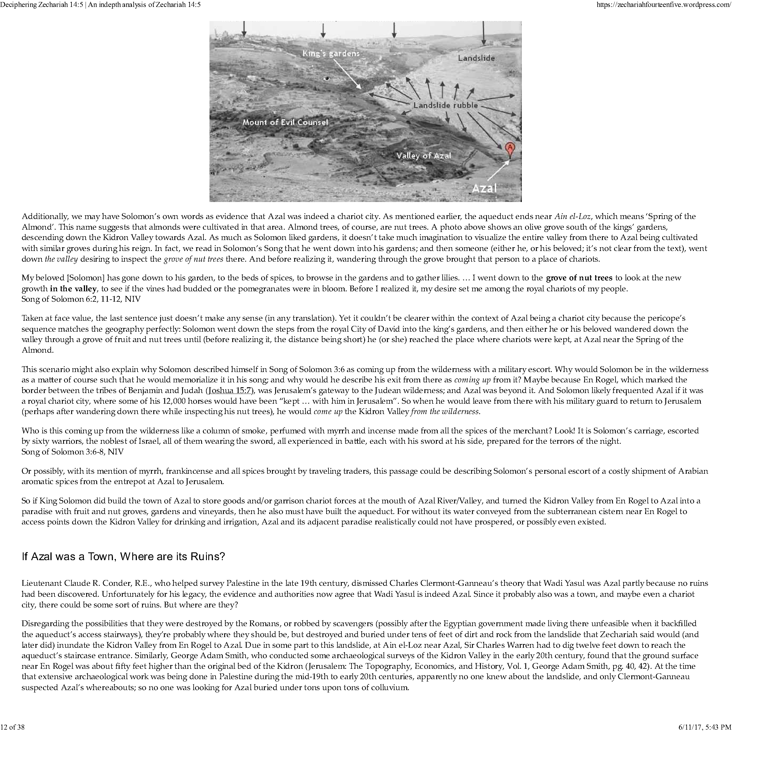
The location of Azal is not certain, but the name
may denote some place near the western extremity of
the valley near Jerusalem or a hamlet on the outskirts of
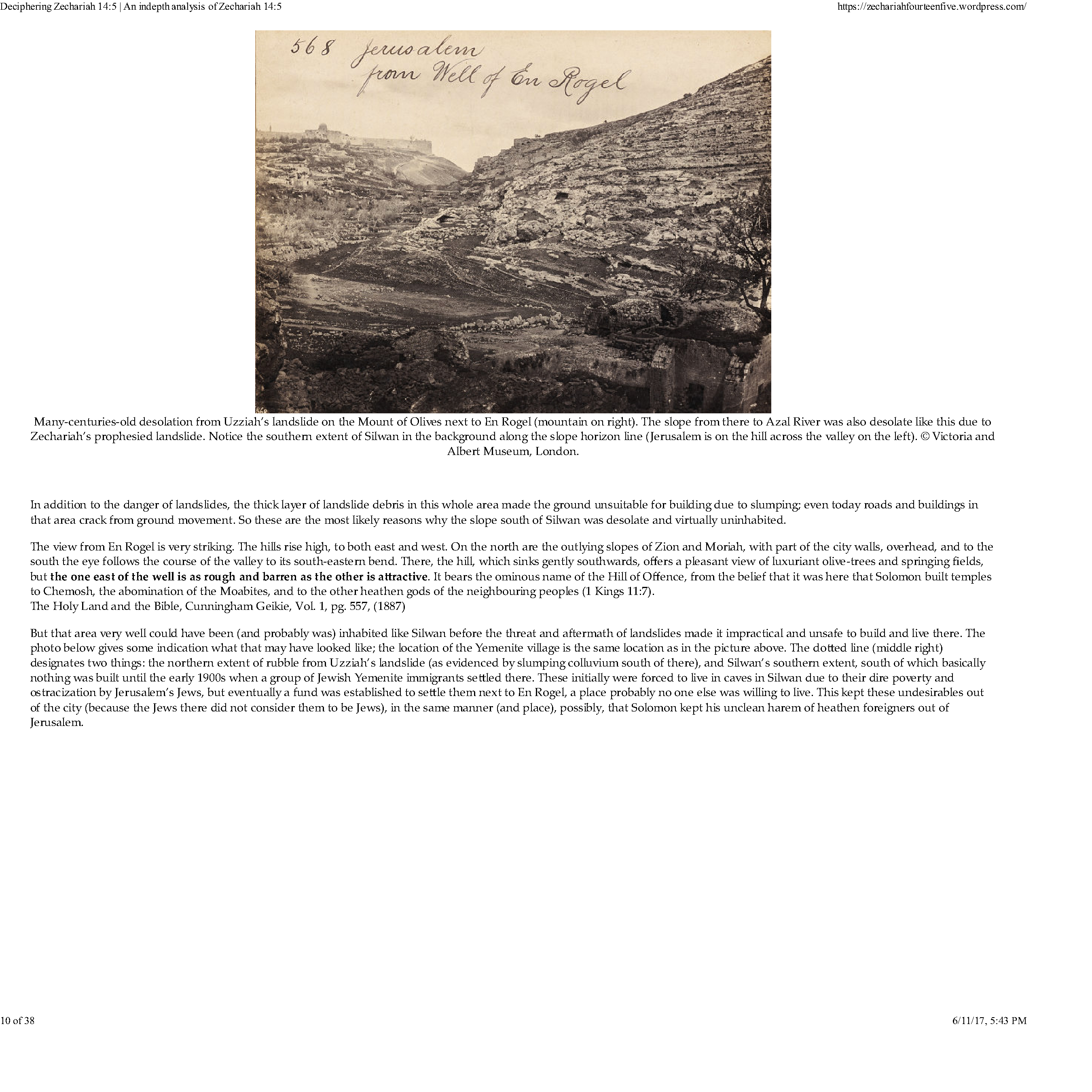
Jerusalem. As for the location of En-rogel, it has been
suggested that it is the fountain of the Virgin, the modern
Ain Umm al-Daraj. Others identify it with Bir Eyub,
to the south of the Pool of Siloam, and below the junction
of the valleys of Kidron and Hinnom, which seems
to be a more probable location, but again this is not
certain.
There remains the question of whether there is
any evidence today for active faulting in the immediate
vicinity of Old Jerusalem that can be associated with the
ground deformations mentioned by Zechariah, Josephus
and Nathan. Old aerial photographs of the chalky geological
formations of the region show only landslides on
steep slopes, but no through-going faults. A relatively
large slide can be recognised on the Mount of Olives,
which is located on the slope which faces west towards the
Old City, the scarp of which can be seen halfway up the
Mount of Olives. However, according to the Geological
Survey of Israel, it is probably much more ancient than
Biblical times (Wachs and Lewitte 1984; Frydman 1997).
The multitude of short scarps shown on relatively recent
geological maps of Jerusalem all teiminate at the Kidron
Valley (Gil 1996). The exception is a short northeastsouthwest-
running fault trace, which is shown on the
Geotechnical Map of Jerusalem (Israeli 1977), which the
Atlas of Israel labels Zechariah 14:4, earthquake fault.
This feature extends from a point a few hundred metres
south of the Jerusalem Railway Station to the west, running
for more than three kilometres, to just north of al-
Ayzariyah to the east, striking about N-70° E (Atlas of
Israel1985). The reason why this feature has been associated
with Zechariah's earthquake is not given.
There is no direct or indirect evidence that
Jerusalem was damaged, and it is interesting that the
details in Josephus concerning the effects of the earthquake
on the temple are not supported by earlier sources,
which remain silent about damage anywhere in Judaea
and Israel [7].
Notes
[1] Amos says that the prophet received visions ‘. . . during
the reigns of Uzziah king of Judah and Jeroboam son of
Jehoash king of Israel, two years before the earthquake . . .’
(Amos, I. 1).
[2] ‘. . . they shall go into the holes of the cracks and into
the caves of the earth when He arises to shake (terrify) the
earth . . .’ (Isa. II. 19, 21).
[3.1] ‘. . . the Lord will go out fully armed for war, to fight against
those nations. That day his feet will stand upon the Mount
of Olives, to the east of Jerusalem, and the Mount of Olives
will split apart, making a very wide valley running from east
to west, for half the mountain will move towards the north
and half toward the south. You will escape through that valley,
for it will reach across to Azel. You will escape as your
people did long centuries ago from the earthquake in the
days of Uzziah, king of Juda . . . [c. 767–753 BC]’ (Zech.
xiv. 4–5).
[3.2] ‘And the mountain will split in half, forming
a wide valley that runs from east to west . . . Then you people will
escape from the Lord’s mountain, through this valley,
which reaches to Azal. You will run in all directions, just
as everyone did when the earthquake struck in the time of
King Uzziah of Judah.’ (Contemporary English Version).
[3.3] ‘And the Mount of Olives shall be split in two from east
to west by a very wide valley; so that one half of the
Mount shall withdraw northward, and the other half southward . . . And the valley of my mountains shall be stopped
up, for the valley of the mountains shall touch the side of
it; and you shall flee as you fled from the earthquake in the
days of Uzzi’ah king of Judah.’ (Revised Standard Version).
[3.4] ‘And the Mount of Olives shall be split in two from east
to west by a very great valley; and half of the mountain
shall remove toward the north and half of it toward the
south . . . And you shall flee by the valley of my mountains;
for the valley of the mountains shall reach to Azel; and you
shall flee, as you fled from before the earthquake in the days
of Uzziah king of Judah.’ (Amplified Bible).
[3.5] ‘And the Mount of Olives shall be split in the midst thereof
toward the east and toward the west, and there shall be a
very great valley; and half of the mountain shall remove
toward the north, and half of it toward the south . . . And you
shall flee by the valley of my mountains; for the valley of the
mountains shall reach unto Azel. And you shall flee, like as
you fled from before the earthquake in the days of Uzziah.’
(American Standard Version).
[3.6] ‘And the Mount of Olives shall cleave in the midst thereof
toward the east and toward the west, and there shall be a
very great valley; and half of the mountain shall remove
toward the north and half of it toward the south . . . And you
shall flee by the valley of my mountains; for the valley of the
mountains shall reach unto Azal; you shall even flee, like as
you fled from before the earthquake in the days of Uzziah
king of Judah.’ (Darby English Version).
[3.7] ‘And the Mount of Olives shall cleave in the midst thereof
toward the east and toward the west, and there shall be a
very great valley; and half of the mountain shall remove
toward the north, and half of it toward the south . . . And you
shall flee to the valley of the mountains; for the valley shall
reach unto Azal; you shall flee, like as you fled from before
the earthquake in the days of Uzziah king of Judah.’ (King
James Version).
[4] ‘And ye shall flee to the valley of the mountains;
for the valley of the mountains shall reach unto Azal . . .’ (Masoretic
text).
[5] ‘And the valley of my mountains shall be stopped up; for
the valley of the mountains shall touch the side of it . . .’
(Revised text).
[6] ‘. . . a great earthquake shook the ground and a rent was
made in the temple, and the bright rays of the sun shone
through it, and fell upon Uzziah’s face, insomuch that the
leprosy seized upon him immediately. And before the city,
at a place called Eroge, half the mountain broke off from
the rest on the west, and rolled itself four furlongs and stood
still at the east mountain, till the roads, as well as the king’s
gardens, were spoiled by the obstruction . . .’ (Joseph.AN:
IX. x. 4).
[6a] ‘. . . when leprosy appeared on Uzziah’s brow, at the same
moment the temple split open and the fissure extended for
twelve miles in each direction . . .’ (Nathan ha-Bavli. ix).
[7] ‘. . . the posts of the temple moved when the Lord spoke . . .’
(2 Chron., XXVI. 16–17; 2 Kings XV.1–7).
References
Ambraseys, N. N. (2009). Earthquakes in the Mediterranean and Middle East: a multidisciplinary study of seismicity up to 1900.
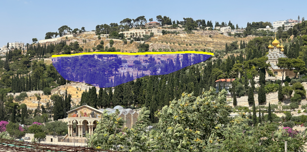
 View of undated landslide above the Church of All Nations on the
Mount of Olives. Approx. Base of Fault Scarp drawn in Yellow. Slide unit marked in tinted blue
View of undated landslide above the Church of All Nations on the
Mount of Olives. Approx. Base of Fault Scarp drawn in Yellow. Slide unit marked in tinted blue