Tell Saidiyeh Archaeoseismic Site
 Tell Saidiyeh in Google Earth
click on image to explore this site on a new tab in Google Earth
| Transliterated Name | Source | Name |
|---|---|---|
| Tell Saidiyeh | Arabic | تل السَّعيديّة |
| Tell Es-Sa'idiyeh | Arabic | تل السَّعيديّة |
- Fig. 1 - Location Map
from Petit & Kafafi (2016)
 Fig. 1
Location Map
Petit & Kafafi (2016) - Location Map from
Van der Kooij (2006)
 Fig. 1
Map of Deir 'Alla region, based upon topographic map 1947
Van der Kooij (2006) - Jordan Valley Sites from
Ferry et al. (2011)
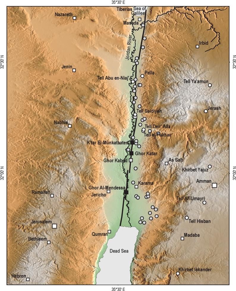 Figure 6
Archaeology of the Jordan Valley.
- White squares, main populated areas cited in historical documents
- white dots, archaeological sites visited and reappraised in this study
- gray dots are archaeological sites not studied here (lack of evidence and/or available literature) but of potential interest for future studies
- gray squares, paleoseismic sites
- black squares, geomorphological sites studied by Ferry et al. (2007)
Ferry et al. (2011)) - Fig. 2 Map of Iron Age I
sites in the Jordan Valley from Halbertsma (2019)
 Figure 2
Map of the Jordan Valley with Iron Age I sites mentioned in the thesis. The open circles are modern cities.
Halbertsma (2019) - Fig. 13 Map of Iron Age sites
in the Jordan Valley from Halbertsma (2019)
 Figure 13
Map of Iron Age sites discussed in this chapter
(after Van der Steen 1999, 179).
Halbertsma (2019) - Fig. 4.1 Map of sites
in central and northern Israel and Jordan from Mazar et. al. (2020 v.1)
 Fig. 4.1
Map of major archaeological and historical site in central and northern Israel and Jordan
Mazar et. al. (2020 v.1) - Fig. 1b Fault segments
in the Jordan Valley from Ferry et al. (2011)
 Figure 1b
Detailed map of the JVF (Jordan Valley Fault) segment between the Sea of Galilee and the Dead Sea. The segment itself is organized as six 15-km to 30-km-long right-stepping sub segments limited by 2 km to 3 km wide transpressive relay zones. The active trace of the JVF (Jordan Valley Fault) continues for a further ~10 km northward into the Sea of Galilee (SG) and ~20 km southward into the northern Dead Sea (DS).
Ferry et al. (2011) - Fig. 3a Geomorphology of
the Jordan Valley fault from Ferry et al. (2011)
 Figure 3a
Geomorphology of the Jordan Valley fault
Central section of the JVF (Jordan Valley Fault) (see location on Fig. 1b), showing drainage (outlined) that is systematically left-laterally displaced at the passage of the fault. The active trace of the JVF (Jordan Valley Fault) is pointed out by the arrows.
Ferry et al (2011)
- Location Map from
Van der Kooij (2006)
Fig. 1
Map of Deir 'Alla region, based upon topographic map 1947
Van der Kooij (2006) - Jordan Valley Sites from
Ferry et al. (2011)
Figure 6
Archaeology of the Jordan Valley.
- White squares, main populated areas cited in historical documents
- white dots, archaeological sites visited and reappraised in this study
- gray dots are archaeological sites not studied here (lack of evidence and/or available literature) but of potential interest for future studies
- gray squares, paleoseismic sites
- black squares, geomorphological sites studied by Ferry et al. (2007)
Ferry et al. (2011)) - Fig. 2 Map of Iron Age I
sites in the Jordan Valley from Halbertsma (2019)
Figure 2
Map of the Jordan Valley with Iron Age I sites mentioned in the thesis. The open circles are modern cities.
Halbertsma (2019) - Fig. 13 Map of Iron Age sites
in the Jordan Valley from Halbertsma (2019)
Figure 13
Map of Iron Age sites discussed in this chapter
(after Van der Steen 1999, 179).
Halbertsma (2019) - Fig. 4.1 Map of sites
in central and northern Israel and Jordan from Mazar et. al. (2020 v.1)
Fig. 4.1
Map of major archaeological and historical site in central and northern Israel and Jordan
Mazar et. al. (2020 v.1) - Fig. 1b Fault segments
in the Jordan Valley from Ferry et al. (2011)
Figure 1b
Detailed map of the JVF (Jordan Valley Fault) segment between the Sea of Galilee and the Dead Sea. The segment itself is organized as six 15-km to 30-km-long right-stepping sub segments limited by 2 km to 3 km wide transpressive relay zones. The active trace of the JVF (Jordan Valley Fault) continues for a further ~10 km northward into the Sea of Galilee (SG) and ~20 km southward into the northern Dead Sea (DS).
Ferry et al. (2011) - Fig. 3a Geomorphology of
the Jordan Valley fault from Ferry et al. (2011)
Figure 3a
Geomorphology of the Jordan Valley fault
Central section of the JVF (Jordan Valley Fault) (see location on Fig. 1b), showing drainage (outlined) that is systematically left-laterally displaced at the passage of the fault. The active trace of the JVF (Jordan Valley Fault) is pointed out by the arrows.
Ferry et al (2011)
- Fig. 8b Aerial View
showing Jordan Valley Fault and Tell from Ferry et al. (2011)
 Figure 8b
the satellite imagery shows the relationship between the active fault trace (thick line), the archaeological site (LT, lower tell; UT, upper tell), and geomorphology (white outline represents the extent of the microtopographic survey in Fig. 3b).
Ferry et al. (2011) - Tell Saidiyeh in Google Earth
Tell Saidiyeh in Google Earth
click on image to explore this site on a new tab in Google Earth
- Fig. 1 Site plan with
excavation areas from Tubb & Dorrell (1993)
 Figure 1
Contour Plan of the site showing excavation areas
Tubb & Dorrell (1993) - Fig. 1 Site plan with
survey grid from Tubb & Dorrell (1994)
 Figure 1
Contour Plan of the site with survey grid showing positions of areas investigated in 1993
Tubb & Dorrell (1994)
- Fig. 1 Site plan with
excavation areas from Tubb & Dorrell (1993)
Figure 1
Contour Plan of the site showing excavation areas
Tubb & Dorrell (1993) - Fig. 1 Site plan with
survey grid from Tubb & Dorrell (1994)
Figure 1
Contour Plan of the site with survey grid showing positions of areas investigated in 1993
Tubb & Dorrell (1994)
- Fig. 2 Location plan for
areas on Upper Tell from Tubb & Dorrell (1993)
 Figure 2
Location plan for areas on Upper Tell
Tubb & Dorrell (1993)
- Fig. 2 Location plan for
areas on Upper Tell from Tubb & Dorrell (1993)
Figure 2
Location plan for areas on Upper Tell
Tubb & Dorrell (1993)
- Fig. 2 Grids for Areas
AA and EE on Upper Tell from Tubb & Dorrell (1991)
 Figure 2
Plan of the AA-EE linkage area showing configuration of trenches and their relationship to the main grid.
Tubb & Dorrell (1991) - Fig. 5 Composite plan
of stratum V Areas AA and EE on Upper Tell from Tubb & Dorrell (1991)
 Figure 5
stratum V. Composite plan of Areas AA and EE (Grid squares 22, 23, 32, and 33) incorporating the southern part of Pritchard's exposure(taken from Pritchard 1986, fig. 79). Again, note that this plan has been simplified for the purposes of this report.
Tubb & Dorrell (1991)
- Fig. 2 Grids for Areas
AA and EE on Upper Tell from Tubb & Dorrell (1991)
Figure 2
Plan of the AA-EE linkage area showing configuration of trenches and their relationship to the main grid.
Tubb & Dorrell (1991) - Fig. 5 Composite plan
of stratum V Areas AA and EE on Upper Tell from Tubb & Dorrell (1991)
Figure 5
stratum V. Composite plan of Areas AA and EE (Grid squares 22, 23, 32, and 33) incorporating the southern part of Pritchard's exposure(taken from Pritchard 1986, fig. 79). Again, note that this plan has been simplified for the purposes of this report.
Tubb & Dorrell (1991)
- Fig. 8 Plan of "Palace"
complex in Area EE in stratum XII from Tubb (1990)
 Figure 8
Area EE, stratum XII: plan of "Palace" complex.
Tubb (1990)
- Fig. 8 Plan of "Palace"
complex in Area EE in stratum XII from Tubb (1990)
Figure 8
Area EE, stratum XII: plan of "Palace" complex.
Tubb (1990)
- Fig. 10 Plan of Western
Palace complex in Area EE from Tubb and Dorrell (1993)
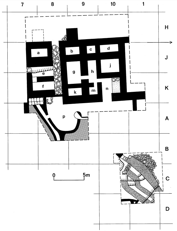 Figure 10
Plan of the Western Palace complex in Area EE (Area 32-A/B-7/10, Area 33-H/K-7/10) and the 'Aqueduct' in AA goo (Area 32-B/D-IO, Area 23-B(D-l/2).
Tubb and Dorrell (1993)
- Fig. 10 Plan of Western
Palace complex in Area EE from Tubb and Dorrell (1993)
Figure 10
Plan of the Western Palace complex in Area EE (Area 32-A/B-7/10, Area 33-H/K-7/10) and the 'Aqueduct' in AA goo (Area 32-B/D-IO, Area 23-B(D-l/2).
Tubb and Dorrell (1993)
- Fig. 24 Stratum XII
alleyway and associated building in area KK from Tubb, Dorrell, & Cobbing (1996)
 Figure 24
Area KK: Remains of Stratum XII alleyway and associated building and part of the underlying phase (Stratum XIII).
Tubb, Dorrell, & Cobbing (1996)
- Fig. 24 Stratum XII
alleyway and associated building in area KK from Tubb, Dorrell, & Cobbing (1996)
Figure 24
Area KK: Remains of Stratum XII alleyway and associated building and part of the underlying phase (Stratum XIII).
Tubb, Dorrell, & Cobbing (1996)
- Fig. 7 Plan of Stratum
VII bathroom in AA 1300 from Tubb and Dorrell (1993)
 Figure 7
Plan of the Stratum VII bathroom in AA 1300 (Area 32-E-7).
Tubb and Dorrell (1993) - Fig. 8 Axonometric
reconstruction of Stratum VII bathroom from Tubb and Dorrell (1993)
 Figure 8
Axonometric reconstruction of Stratum VII bathroom.
Tubb and Dorrell (1993)
- Fig. 7 Plan of Stratum
VII bathroom in AA 1300 from Tubb and Dorrell (1993)
Figure 7
Plan of the Stratum VII bathroom in AA 1300 (Area 32-E-7).
Tubb and Dorrell (1993) - Fig. 8 Axonometric
reconstruction of Stratum VII bathroom from Tubb and Dorrell (1993)
Figure 8
Axonometric reconstruction of Stratum VII bathroom.
Tubb and Dorrell (1993)
- Fig. 3 Plan of Hellenistic
building (Stratum IIA) in Area 32 from Tubb and Dorrell (1993)
 Figure 3
Plan of Hellenistic building (Stratum IIA) in Area 32. The plan is a composite, drawing together Pritchard's work in E/G-8, the excavation of AA 700 in 1989(H/J-8), and the most recent results from AA 1300 (E/G-6/7).
Tubb and Dorrell (1993)
- Fig. 3 Plan of Hellenistic
building (Stratum IIA) in Area 32 from Tubb and Dorrell (1993)
Figure 3
Plan of Hellenistic building (Stratum IIA) in Area 32. The plan is a composite, drawing together Pritchard's work in E/G-8, the excavation of AA 700 in 1989(H/J-8), and the most recent results from AA 1300 (E/G-6/7).
Tubb and Dorrell (1993)
- Fig. 2 Plan of the
Persian period Residency in Area 31 from Tubb & Dorrell (1994)
 Figure 2
Plan of the Persian period Residency in Area 31 (taken from Pritchard 1985, fig. 185) showing position of the 1993 sounding.
Tubb & Dorrell (1994)
- Fig. 2 Plan of the
Persian period Residency in Area 31 from Tubb & Dorrell (1994)
Figure 2
Plan of the Persian period Residency in Area 31 (taken from Pritchard 1985, fig. 185) showing position of the 1993 sounding.
Tubb & Dorrell (1994)
- Fig. 8 Plan of Field I
from Tubb, Dorrell, & Cobbing (1996)
 Figure 8
Overall plan of Field I showing the possible relationship between the Early Bronze Age architecture of Area BB 100-600, and that of Areas BB 700/DD.
Tubb, Dorrell, & Cobbing (1996) - Fig. 3 Plan of Field I
from Tubb, Dorrell, & Cobbing (1997)
 Figure 3
Overall plan of Field I (Lower Tell) showing architecture relating to the Early Bronze Age complex(es) in Areas BB and DD (revised since 1995).
Tubb, Dorrell, & Cobbing (1997)
- Fig. 8 Plan of Field I
from Tubb, Dorrell, & Cobbing (1996)
Figure 8
Overall plan of Field I showing the possible relationship between the Early Bronze Age architecture of Area BB 100-600, and that of Areas BB 700/DD.
Tubb, Dorrell, & Cobbing (1996) - Fig. 3 Plan of Field I
from Tubb, Dorrell, & Cobbing (1997)
Figure 3
Overall plan of Field I (Lower Tell) showing architecture relating to the Early Bronze Age complex(es) in Areas BB and DD (revised since 1995).
Tubb, Dorrell, & Cobbing (1997)
- Fig. 13 Location plan for
areas on Upper Tell from Tubb & Dorrell (1993)

Figure 13
Plan of Square BB 700 (Grid F/G-1/2) at Phase L2. The numbered artifacts are:
- store-Jar
- store-Jar
- open-mouth vessel
- Juglet
- Jug
- store-Jar
- store-Jar
- beaker
- jug
- door-socket
- bowl
- jug
- platter
- flint scraper
- Juglet
- platter
- platter
- Jug
- Juglet
- juglet
- bowl
- juglet
- group of 3 juglets
- open-mouth vessel
- store-jar
- store-Jar
- Jug
- sunken stone bowl
Tubb & Dorrell (1993)
- Fig. 13 Location plan for
areas on Upper Tell from Tubb & Dorrell (1993)
Figure 13
Plan of Square BB 700 (Grid F/G-1/2) at Phase L2. The numbered artifacts are:
- store-Jar
- store-Jar
- open-mouth vessel
- Juglet
- Jug
- store-Jar
- store-Jar
- beaker
- jug
- door-socket
- bowl
- jug
- platter
- flint scraper
- Juglet
- platter
- platter
- Jug
- Juglet
- juglet
- bowl
- juglet
- group of 3 juglets
- open-mouth vessel
- store-jar
- store-Jar
- Jug
- sunken stone bowl
Tubb & Dorrell (1993)
- Fig. 16 Plan of Stratum
L2 in Area BB 700 from Tubb and Dorrell (1993)
 Figure 16
Plan of Stratum L2 in Area BB 700 (Area 35-F/H-I/3).
Tubb and Dorrell (1993) - Fig. 12 Plan of Stratum
L2 in BB 700 from Tubb & Dorrell (1994)
 Figure 12
Plan of Stratum L2 (revised 1993) in BB 700.
Tubb & Dorrell (1994)
- Fig. 16 Plan of Stratum
L2 in Area BB 700 from Tubb and Dorrell (1993)
Figure 16
Plan of Stratum L2 in Area BB 700 (Area 35-F/H-I/3).
Tubb and Dorrell (1993) - Fig. 12 Plan of Stratum
L2 in BB 700 from Tubb & Dorrell (1994)
Figure 12
Plan of Stratum L2 (revised 1993) in BB 700.
Tubb & Dorrell (1994)
- Fig. 17 Plan of Stratum
L2 in Area BB 700 from Tubb and Dorrell (1993)
 Figure 17
Plan of Stratum LI in Area BB 700 (Area 35-F/H-1/3)
Tubb and Dorrell (1993) - Fig. 10 Plan of Stratum
LI in BB 700 from Tubb & Dorrell (1994)
 Figure 10
Plan of Stratum LI (revised in view of 1993 excavations) in BB 700.
Tubb & Dorrell (1994)
- Fig. 17 Plan of Stratum
L2 in Area BB 700 from Tubb and Dorrell (1993)
Figure 17
Plan of Stratum LI in Area BB 700 (Area 35-F/H-1/3)
Tubb and Dorrell (1993) - Fig. 10 Plan of Stratum
LI in BB 700 from Tubb & Dorrell (1994)
Figure 10
Plan of Stratum LI (revised in view of 1993 excavations) in BB 700.
Tubb & Dorrell (1994)
- Fig. 9 Sketch of the
Early Bronze Age complex in BB 700 from Tubb & Dorrell (1994)
 Figure 9
Sketch reconstruction of the Early Bronze Age complex in BB 700 looking north-east (not to scale).
Tubb & Dorrell (1994)
- Fig. 9 Sketch of the
Early Bronze Age complex in BB 700 from Tubb & Dorrell (1994)
Figure 9
Sketch reconstruction of the Early Bronze Age complex in BB 700 looking north-east (not to scale).
Tubb & Dorrell (1994)
- Fig. 4 Location plan
for general loci within areas BB 700 and DD from Tubb, Dorrell, & Cobbing (1997)
 Figure 4
Location plan for general loci within areas BB 700 and DD.
Tubb, Dorrell, & Cobbing (1997)
- Fig. 4 Location plan
for general loci within areas BB 700 and DD from Tubb, Dorrell, & Cobbing (1997)
Figure 4
Location plan for general loci within areas BB 700 and DD.
Tubb, Dorrell, & Cobbing (1997)
- Fig. 7 Area DD: Covered
drain and bath installation associated with Stratum L2 from Tubb, Dorrell, & Cobbing (1996)
 Figure 7
Area DD: Covered drain and bath installation associated with Stratum L2.
Tubb, Dorrell, & Cobbing (1996)
- Fig. 7 Area DD: Covered
drain and bath installation associated with Stratum L2 from Tubb, Dorrell, & Cobbing (1996)
Figure 7
Area DD: Covered drain and bath installation associated with Stratum L2.
Tubb, Dorrell, & Cobbing (1996)
- Fig. 13 Plan of 'scullery'
area in DD900 from Tubb, Dorrell, & Cobbing (1997)
 Figure 13
Plan of 'scullery' area in DD900.
Tubb, Dorrell, & Cobbing (1997)
- Fig. 13 Plan of 'scullery'
area in DD900 from Tubb, Dorrell, & Cobbing (1997)
Figure 13
Plan of 'scullery' area in DD900.
Tubb, Dorrell, & Cobbing (1997)
- Fig. 46 - Iron age Section
above stratum XII in Area AA from Tubb et al. (1990)
 Fig. 46
Drawing of the main east section in Area AA showing complicated sequence of Iron Age occupation phases above stratum XII
(photo:JNI)
Tubb et al. (1990) - Fig. 4 AA 1300 (Area 32-E/G-6/7)
West Section from Tubb and Dorrell (1993)
 Figure 4
AA 1300 (Area 32-E/G-6/7) West Section
Tubb and Dorrell (1993) - Fig. 6 AA 1000/1100 (Area 32-C/E-7/9)
South Section from Tubb and Dorrell (1993)
 Figure 6
AA 1000/1100 (Area 32-C/E-7/9) South Section
Tubb and Dorrell (1993) - Fig. 2 North Section BB 900-1000
showing two phases of destruction of Stratum L2 staircase and evidence of faulting through seismic activity from Tubb, Dorrell, and Cobbing (1996)
 Figure 2
Area BB 700: North Section BB 900- 1000 showing two phases of destruction of Stratum L2 ' staircase and evidence of faulting through seismic activity
Tubb, Dorrell, and Cobbing (1996) - Fig. 4 South and West
sections of 31-H-7 showing the stratigraphic sequence of phases below Stratum III from Tubb & Dorrell (1994)
 Figure 4
South and West sections of 31-H-7 showing the stratigraphic sequence of phases below Stratum III.
Tubb & Dorrell (1994)
- Fig. 46 - Iron age Section
above stratum XII in Area AA from Tubb et al. (1990)
Fig. 46
Drawing of the main east section in Area AA showing complicated sequence of Iron Age occupation phases above stratum XII
(photo:JNI)
Tubb et al. (1990) - Fig. 4 AA 1300 (Area 32-E/G-6/7)
West Section from Tubb and Dorrell (1993)
Figure 4
AA 1300 (Area 32-E/G-6/7) West Section
Tubb and Dorrell (1993) - Fig. 6 AA 1000/1100 (Area 32-C/E-7/9)
South Section from Tubb and Dorrell (1993)
Figure 6
AA 1000/1100 (Area 32-C/E-7/9) South Section
Tubb and Dorrell (1993) - Fig. 2 North Section BB 900-1000
showing two phases of destruction of Stratum L2 staircase and evidence of faulting through seismic activity from Tubb, Dorrell, and Cobbing (1996)
Figure 2
Area BB 700: North Section BB 900- 1000 showing two phases of destruction of Stratum L2 ' staircase and evidence of faulting through seismic activity
Tubb, Dorrell, and Cobbing (1996) - Fig. 4 South and West
sections of 31-H-7 showing the stratigraphic sequence of phases below Stratum III from Tubb & Dorrell (1994)
Figure 4
South and West sections of 31-H-7 showing the stratigraphic sequence of phases below Stratum III.
Tubb & Dorrell (1994)
- Fig. 8a and 8b Photo of tell
and its relationship to the Jordan Valley Fault from Ferry et al. (2011)
 Figure 8a and 8b
Tell Saydiyeh archaeological site. (a,b) General view of the site and satellite imagery (inset) showing its relationship to the fault. The archaeological site is composed with a lower and an upper tell that were occupied at different periods. The original site was a limited mound that looked over the region and has grown with the successive addition of settlement layers, each related to a specific period.The obvious proximity of the JVF is marked by the active fault scarp. In (b), the satellite imagery shows the relationship between the active fault trace (thick line), the archaeological site (LT, lower tell; UT, upper tell), and geomorphology (white outline represents the extent of the microtopographic survey in Fig. 3b).
Ferry et al. (2011) - Fig. 8c Burn layer at
tell from Ferry et al. (2011)
 Figure 8c
Tell Saydiyeh archaeological site. Open pit at the top of the tell showing conspicuous ~5-cm-thick black burnt layers. Those layers contain broken pottery, charred wood, and ashes and are remnants of a widespread intense fire.
Ferry et al. (2011) - Fig. 8d 12th century
BCE olive processing area (Palace) that displays signs of destruction from Ferry et al. (2011)
 Figure 8d
The twelfth century B.C. olive processing area (Palace) that displays signs of destruction
(from Tubb, 1998)
Ferry et al. (2011) - Fig. 8e Blocked doorway
and broken vessel interpreted as a direct result of earthquake shaking from Ferry et al. (2011)
 Figure 8e
Blocked doorway and broken vessel interpreted as a direct result of earthquake shaking
(from Tubb, 1988)
Ferry et al. (2011) - Fig. 9 overhead view
of "Palace" in Area EE, stratum XII from Tubb (1990)
 Figure 9
Area EE, stratum XII: overhead view of "Palace"
Tubb (1990) - Fig. 10 Crushed pottery
adjacent to water channel in westernmost plastered room of Area EE, stratum XII from Tubb (1990)
 Figure 10
Area EE, stratum XII: water channel in westernmost plastered room. The crushed pottery vessel near to the scale is that shown on Fig. 14:1.
Tubb (1990) - Fig. 12 mud-brick paving
in room of "Palace" complex in Area EE, stratum XII from Tubb (1990)
 Figure 12
Area EE, stratum XII: mud-brick paving in room of "Palace" complex
Tubb (1990) - Fig. 13 pottery vessels
on burnt floor of "Palace" in Area EE, stratum XII from Tubb (1990)
 Figure 13
Area EE, stratum XII: pottery vessels on burnt floor of "Palace", close to tabun constructed of krater sherds
Tubb (1990) - Fig. 4 Area AA 900 showing
stalls and depressed stone-paved surface of stratum VII from Tubb and Dorrell (1991)
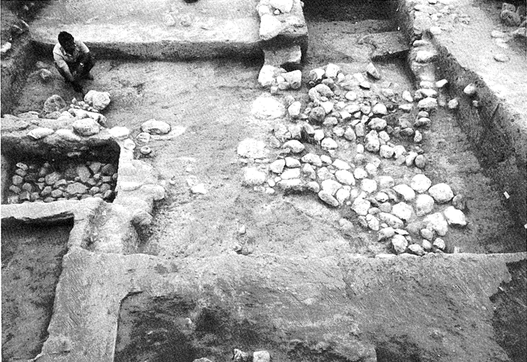 Figure 4
AA 900 from the west. The stratum V stalls are on the left of the photograph, and on the right is the depressed stone-paved surface of stratum VII.
Tubb and Dorrell (1991) - Fig. 16 Brick Collapse and
destruction debris in BB700 (Early Bronze II) from Tubb and Dorrell (1991)
 Figure 16
Deposit of Early Bronze II pottery, in situ, showing nature of overlying brick collapse and destruction debris (BB 700).
Tubb and Dorrell (1991) - Fig. 17 Early Bronze II pottery
(in situ) on the floor of the stratum L2 building in BB 700 from Tubb and Dorrell (1991)
 Figure 17
Deposit of Early Bronze II pottery, in situ, on the floor of the stratum L2 building in BB 700.
Tubb and Dorrell (1991) - Fig. 5 Deep storage
pit of Stratum IV in AA 1300 from Tubb & Dorrell (1993)
 Figure 5
AA 1300. Deep storage pit of Stratum IV. The rim of another such pit is shown at the top of the photograph.
Tubb & Dorrell (1993) - Fig. 9 Basalt tripod-stand
on floor of Stratum VII bathroom from Tubb & Dorrell (1993)
 Figure 9
Basalt tripod-stand on floor of Stratum VII bathroom.
Tubb & Dorrell (1993) - Fig. 11 View over Area
AA 900 Stratum XII from Tubb & Dorrell (1993)
 Figure 11
View over Area AA 900 from the southwest, showing the walls, passageways and revetment of the 'Aqueduct' of Stratum XII.
Tubb & Dorrell (1993) - Fig. 12 Stone revetment
against western wall of aqueduct in AA 900 from Tubb & Dorrell (1993)
 Figure 12
Stone revetment against western wall of aqueduct in AA 900.
Tubb & Dorrell (1993) - Fig. 13 Part of Area EE
Stratum XII from Tubb & Dorrell (1993)
 Figure 13
Part of Area EE from the south, showing the Stratum XII pool with its inlet and riser on the north side.
Tubb & Dorrell (1993) - Fig. 14 Broken Jars in
Area EE Stratum XII from Tubb & Dorrell (1993)
 Figure 14
Egyptian style jars adjacent to the drainage channel of the Stratum XII pool in Area EE.
Tubb & Dorrell (1993) - Fig. 15 Area BB 700
from Tubb & Dorrell (1993)
 Figure 15
General view of excavations in Area BB 700, looking north-west. Room d is in the foreground
Tubb & Dorrell (1993) - Fig. 18 Broken and fallen
in situ Early Bronze II pottery in Room b of Area BB 700 Stratum L2 from Tubb & Dorrell (1993)
 Figure 18
Early Bronze II pottery in situ in Room b (Area BB 700, Stratum L2).
Tubb & Dorrell (1993) - Fig. 19 Cracked steps
leading down into Room d of Area BB 700 Stratum L2 from Tubb & Dorrell (1993)
 Figure 19
Area BB 700. Steps leading down into Room d (Stratum L2).
Tubb & Dorrell (1993) - Fig. 20 Tilted Wall in
Area BB 700 from Tubb & Dorrell (1993)
 Figure 20
Area BB 700. Angle between Walls H and P, showing L1 addition to L2 walls.
Tubb & Dorrell (1993) - Fig. 21 Area BB 700
Stratum L2 from Tubb & Dorrell (1993)
 Figure 21
Area BB 700. Dish in niche in Wall H (Stratum L2)
Tubb & Dorrell (1993) - Fig. 22 Platter broken
in situ on the floor of Room e from Tubb & Dorrell (1993)
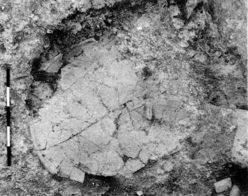 Figure 22
Area BB 700. Platter broken in situ on the floor of Room e (Stratum L1).
Tubb & Dorrell (1993) - Fig. 23 Fire pit in Area BB 700
from Tubb & Dorrell (1993)
 Figure 23
Area BB 700. Fire pit in Lr levels of Rooms e and h.
Tubb & Dorrell (1993) - Fig. 14 Collapse in BB700
and Stratum L2 from Tubb and Dorrell (1991)
 Figure 14
BB 700: stratum L2 building from the west.
Tubb and Dorrell (1991) - Fig. 5 Disrupted wall
of Stratum IIIB-C at 31-H-7 from Tubb & Dorrell (1994)
 Figure 5
View of 31-H-7 showing disrupted north-south wall of Stratum IIIB-C.
Tubb & Dorrell (1994) - Fig. 11 Stone-lined pit
of Stratum LI in BB 900 from Tubb & Dorrell (1994)
 Figure 11
Stone-lined pit of Stratum LI in BB 900 (partially revealed in 1992).
Tubb & Dorrell (1994) - Fig. 13 Sunken store-room
in the Early Bronze Age complex in BB 700 from Tubb & Dorrell (1994)
 Figure 13
Sunken store-room in the Early Bronze Age complex in BB 700, showing entrance and steps.
Tubb & Dorrell (1994) - Fig. 14 Smashed storage
jars on the floor of the Early Bronze Age sunken room from Tubb & Dorrell (1994)
 Figure 14
Large store-jars, smashed on the floor of the Early Bronze Age sunken room.
Tubb & Dorrell (1994) - Fig. 15 Mud-brick paved
staircase on the north side of the Early Bronze Age complex (Stratum L2) from Tubb & Dorrell (1994)
 Figure 15
Mud-brick paved staircase on the north side of the Early Bronze Age complex (Stratum L2).
Tubb & Dorrell (1994) - Fig. 16 Small room of
Stratum L3 in BB 1000 from Tubb & Dorrell (1994)
 Figure 16
Small room of Stratum L3 in BB 1000, showing niche (on right hand side) and crushing basin with associated channel.
Tubb & Dorrell (1994) - Fig. 3 Early Bronze II
pottery assemblage in situ in area BB 700 from Tubb, Dorrell, and Cobbing (1996)
 Figure 3
Area BB 700: Early Bronze II pottery assemblage in situ in BB 1100.
Tubb, Dorrell, and Cobbing (1996) - Fig. 4 Area DD
from Tubb, Dorrell, and Cobbing (1996)
 Figure 4
Area DD: General view looking east showing the extent of the season's excavations (DD 700-900).
Tubb, Dorrell, and Cobbing (1996) - Fig. 5 Exposed Wall
in Area DD from Tubb, Dorrell, and Cobbing (1996)
 Figure 5
Area DD: View of the exposed wall which provides the linkage between the architecture of Area DD and that of Area BB 700 (DD 900).
Tubb, Dorrell, and Cobbing (1996) - Fig. 6 Drainage installation
in Area DD from Tubb, Dorrell, and Cobbing (1996)
 Figure 6
Area DD: View from south of the Early Bronze Age drainage installation, consisting of a plaster lined 'bath' with its own drain leading into a larger drain (DD 700).
Tubb, Dorrell, and Cobbing (1996) - Fig. 16 Area AA
from Tubb, Dorrell, and Cobbing (1996)
 Figure 16
Area AA: General view from east during excavation of Stratum XIII showing, on the left, the remains of the stone terracing of Stratum XII. The tannur installation belongs to Stratum XIB.
Tubb, Dorrell, and Cobbing (1996) - Fig. 17 Area AA
from Tubb, Dorrell, and Cobbing (1996)
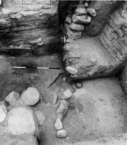 Figure 17
Area AA: Mud-brick and stone blocking of northern entrance to the Stratum XII Egyptian Governor's Residency. Part of the Stratum XIII occupation surface is visible in the foreground.
Tubb, Dorrell, and Cobbing (1996) - Fig. 18 Area AA
from Tubb, Dorrell, and Cobbing (1996)
 Figure 18
Area AA: General view from South looking into the 1995 season's excavation area.
Tubb, Dorrell, and Cobbing (1996) - Fig. 19 Area AA
from Tubb, Dorrell, and Cobbing (1996)
 Figure 19
Area AA: Limestone slab in situ blocking entrance to the underground favissa most likely to be associated with the small Stratum XIA temple excavated in the 1986 season.
Tubb, Dorrell, and Cobbing (1996) - Fig. 21 View of
Tell es-Saeidiyeh and Area KK from Tubb, Dorrell, and Cobbing (1996)
 Figure 21
Area KK: View of Tell es-Saeidiyeh and Area KK from the south.
Tubb, Dorrell, and Cobbing (1996) - Fig. 5 Faulted floor
from Tubb, Dorrell, & Cobbing (1997)
Figure 5
Example of faulting on floor surface, a feature also visible in the section behind (BB 1000).
Tubb, Dorrell, & Cobbing (1997) - Fig. 6 General view
of BB 1000 showing original features of Stratum L2 from Tubb, Dorrell, & Cobbing (1997)
 Figure 6
General view of BB 1000 showing original features of Stratum L2.
Tubb, Dorrell, & Cobbing (1997) - Fig. 7 in situ pottery
on the surface of the upper storey collapse in BB 1300 from Tubb, Dorrell, & Cobbing (1997)
 Figure 7
BB 1300, showing pottery in situ on the surface of the upper storey collapse.
Tubb, Dorrell, & Cobbing (1997) - Fig. 8 stone-lined pit
in BB 1100 from Tubb, Dorrell, & Cobbing (1997)
 Figure 8
BB 1100: stone-lined pit set into first-floor surface.
Tubb, Dorrell, & Cobbing (1997) - Fig. 9 east-west wall
showing the effects of slippage and faulting in BB 1100/I300 from Tubb, Dorrell, & Cobbing (1997)
 Figure 9
BB 1100/I300: substantial east-west wall showing the effects of slippage and faulting.
Tubb, Dorrell, & Cobbing (1997) - Fig. 10 Stratum L1
occupation resting on western wall of Stratum L2 'scullery' in DD 900 from Tubb, Dorrell, & Cobbing (1997)
 Figure 10
DD 900: Poorly preserved remains of Stratum L1 occupation resting on western wall of Stratum L2 'scullery'.
Tubb, Dorrell, & Cobbing (1997) - Fig. 11 Area DD 900
from Tubb, Dorrell, & Cobbing (1997)
 Figure 11
General view of rooms excavated on the south side of Area DD (DD 900) in 1996.
Tubb, Dorrell, & Cobbing (1997) - Fig. 12 Broken platters
and vessels in 'scullery' area in DD 900 from Tubb, Dorrell, & Cobbing (1997)
 Figure 12
View from the north of 'scullery' area in DD 900, showing platters and other vessels on surface.
Tubb, Dorrell, & Cobbing (1997) - Fig. 14 Stack of bowls
in situ in scullery area from Tubb, Dorrell, & Cobbing (1997)
 Figure 14
Stack of bowls in situ in scullery area.
Tubb, Dorrell, & Cobbing (1997) - Fig. 15 Room to south of
'scullery' from Tubb, Dorrell, & Cobbing (1997)
 Figure 15
Room to south of 'scullery', showing well-preserved entrance on south side.
Tubb, Dorrell, & Cobbing (1997) - Fig. 16 Plaster-lined bin
in a small room of 'western complex' (DD 700) from Tubb, Dorrell, & Cobbing (1997)
 Figure 16
Plaster-lined bin in a small room of 'western complex' (DD 700).
Tubb, Dorrell, & Cobbing (1997) - Fig. 17 General view of
Area NN, west of the Lower Tell from Tubb, Dorrell, & Cobbing (1997)
 Figure 17
General view of Area NN, west of the Lower Tell.
Tubb, Dorrell, & Cobbing (1997) - Fig. 18 Early Bronze I
city wall in Area NN from Tubb, Dorrell, & Cobbing (1997)
 Figure 18
Badly weathered Early Bronze I city wall in Area NN.
Tubb, Dorrell, & Cobbing (1997) - Fig. 23 City wall (Stratum 13)
in west section of Area KK from Tubb, Dorrell, & Cobbing (1997)
 Figure 23
City wall (Stratum 13) in west section of Area KK.
Tubb, Dorrell, & Cobbing (1997) - Fig. 24 Part of Stratum
14 building in Area KK from Tubb, Dorrell, & Cobbing (1997)
 Figure 24
Part of Stratum 14 building in Area KK, showing cobble floor with inset pottery bowl (latethirteenth century B.C.).
Tubb, Dorrell, & Cobbing (1997) - Seismic Faulting under
Early Bronze Age debris from Pritchard (1965b)
 Fault produced by an earthquake that disturbed the striations of the virgin soil immediately under the debris of the Early Bronze Age
Pritchard (1965b)
Before proceeding to discuss the linking together of areas AA and EE on the Upper Tell, and in order that the significance of this operation may be appreciated, it will be necessary to review briefly the stratigraphic situation in both areas.
In 1985-87, Area AA had consisted of a relatively small area situated in the south-eastern corner of Pritchard's large exposure of the 1960s(see Tubb 1988, 28). Here, excavations revealed poorly preserved and fragmentary remains of stratum VI, a phase which in fact Pritchard had partially exposed before his work was terminated in 1967. Below were found the better preserved and architecturally coherent remains of stratum VII, a city level of the ninth-eighth century B.C. which had been extensively revealed by the Pennsylvania expedition in the area lying just to the north of Area AA (see Pritchard 1985,fig. 177and Tubb 1988,fig. 4).
Stratum VIII, a non-architectural phase of industrial usage, was characterized by fine ashy deposits, extremely dense in places, emanating from areas of intense heat generation which had been created by the rough modification of the abandoned architectural elements of stratum IX. In places, for example, stratum IX walls had been re-used to form the backs of scooped out, level platforms, which had then served as the sites for some industrial process, the nature of which is still unknown. Whatever the process might have been, it produced a large volume of ashy waste, and this was seen to have covered the abandoned remains of stratum IX, lying thickly where it had slumped into the various rooms and chambers, but appearing as little more than a thin greyish-black band where it had risen over more elevated ground.
Below stratum VIII, and above the large public building of stratum XII excavated at the end of the 1987 season, three architectural phases were isolated, the uppermost, stratum IX, as mentioned above, having been abandoned. Although stratum IX had suffered considerable damage through weathering and erosion, two phase (IXA and IXB) of a quite large building were found, together with part of its associated, wellconstructed, stone-paved courtyard (Tubb 1988, 34- 35).
Stratum X was also characterized by a well-built stone courtyard, but in this case it was associated with unusual, partially sunken, stone-lined structures which were interpreted as pens for livestock. The courtyard was found to belong to a massive, stone-constructed building, only one small corner of which was revealed within the excavation area, the remainder lying to the north and west (Tubb 1988, 35-37).
A similar but less massive building clearly occupied the same position in stratum XIA, but here, to the south-east, and separated from it by a north-south street, was found a small bi-partite building which, on the basis of various internal installations and finds, could be interpreted as a temple (see Tubb 1988, 37-39).
Stratum XIA was found to have been built on a dense layer of silting which in turn covered the deep deposit of intensely burnt destruction debris overlying the architecture of stratum XII. Excavation of stratum XII in 1987 uncovered the remains of a large public building which, to judge from its Egyptian-style plan and construction method, must be seen as yet another example of a so-called 'Egyptian Governor's Residency'. The building had clearly been abandoned following its destruction, and, to. judge from the depth of silt overlying the collapsed debris, some considerable period of time must have elapsed before the construction of stratum XIA, perhaps as much as one hundred years.
Within two of the rooms of the residency, evidence was found for a phase of squatter or camp-site occupation immediately following the destruction. The collapsed debris appeared to have been levelled, and rough surfaces had been made within the confines of the still standing walls. Represented only by hearths and grinding stones, this phase is referred to as stratum XIB (see Tubb 1988, 39-40).
In 1989, Area AA was greatly expanded to the west, and a large extent of the stratum VII city was cleared (see Fig. 3: Houses 73-79). The expansion also demonstrated that stratum VI, defined and excavated by Pritchard in the area to the north of AA 100-500, did not extend to the western side of the tell, but terminated along an approximately north-south line in AA 800/1100 (see Tubb 1990, 21-26 for details of the 1989 season).
 Preliminary Stratigraphy of Area AA
Tubb and Dorrell (1991)
Excavations in Area EE in 1986-89 had produced a rather different, or more accurately, a greatly compressed sequence. For here, stratum VI was found to be absent, and no evidence at all was found for strata VIII, IX, X or XI. Indeed stratum VII was found to overlie stratum XII directly, and it was clear in places that a levelling operation had been conducted prior to the construction of stratum VII, a process which had truncated the wall tops of the western public building complex to almost uniform heights. This levelling process would, of course, have removed all traces of strata VIII, IX, X and XI, especially if, as seems likely, these phases had been built on the internal downslope created by the destruction of the massive stratum -XII city wall and 'palace' complex. In other words, it is. impossible from the evidence in Area EE to establish whether strata VIII, IX, X and XI had been cut out by the levelling operation for stratum VII, or whether these phases had simply never existed on this western side of the site.
To a large extent, excavations in 1990have answered this important question. In AA 900, and in its westward extension 950 (below the level of the stratum III cutting-see below), excavations first revealed remains of stratum V (Fig. 4). Two small, rectangular, partially sunken structures were found, built of poor quality mud-brick (see Fig. 5: 23-B/C-l). The eastern room, which had a finely paved stone floor, measured only 1·52 m. (north-south) by 1·20m. (east-west). A small stone door socket found close to the external south -east corner suggests a door opening outwards, and one which most probably occupied the whole width of the room. The western room was somewhat larger, with internal dimensions of 1·76 m. (north-south) by 1·30 m. (eastwest). The floor in this case was of beaten earth, and no evidence was found for the doorway. The eastern room contained the partially articulated skeleton of a young equid, and the western room contained the more fragmentary skeletal remains of a similar, but adult animal. It would seem reasonable to suggest an interpretation for these two small rooms as stalls, the unfortunate animals presumably having been abandoned and killed during the destruction of stratum V.
In theory, the eastern of the two 'stalls' ought to have been excavated and recorded by Pritchard, since it lies well within the area cleared by him down to stratum V (see Pritchard 1985, fig. 179-square 23-C-l). The reason for its omission from his plan lies in the fact that stratum V, at this particular point, appears to have been founded at a lower level than elsewhere. Pritchard had simply not excavated deeply enough. As will be seen below with regard to stratum VII, the depression /of stratum V at this point was due to the subsidence of the underlying stratigraphy, resulting ultimately from the unusual configuration of stratum XII. In any event, it is now possible to. add the two stalls to the south of Pritchard's House 25, where they would presumably have bordered the east~west street in 23-(B)C/G-l, 32- (B)C/G-I0 (see Pritchard 1985, fig. 179).
Below stratum V excavations revealed further remains of stratum VII (see also Fig. 4). ...
Before proceeding to discuss the linking together of areas AA and EE on the Upper Tell, and in order that the significance of this operation may be appreciated, it will be necessary to review briefly the stratigraphic situation in both areas.
In 1985-87, Area AA had consisted of a relatively small area situated in the south-eastern corner of Pritchard's large exposure of the 1960s (see Tubb 1988, 28). Here, excavations revealed poorly preserved and fragmentary remains of stratum VI, a phase which in fact Pritchard had partially exposed before his work was terminated in 1967. Below were found the better preserved and architecturally coherent remains of stratum VII, a city level of the ninth-eighth century B.C. which had been extensively revealed by the Pennsylvania expedition in the area lying just to the north of Area AA (see Pritchard 1985,fig. 177and Tubb 1988,fig. 4).
Stratum VIII, a non-architectural phase of industrial usage, was characterized by fine ashy deposits, extremely dense in places, emanating from areas of intense heat generation which had been created by the rough modification of the abandoned architectural elements of stratum IX. In places, for example, stratum IX walls had been re-used to form the backs of scooped out, level platforms, which had then served as the sites for some industrial process, the nature of which is still unknown. Whatever the process might have been, it produced a large volume of ashy waste, and this was seen to have covered the abandoned remains of stratum IX, lying thickly where it had slumped into the various rooms and chambers, but appearing as little more than a thin greyish-black band where it had risen over more elevated ground.
Below stratum VIII, and above the large public building of stratum XII excavated at the end of the 1987 season, three architectural phases were isolated, the uppermost, stratum IX, as mentioned above, having been abandoned. Although stratum IX had suffered considerable damage through weathering and erosion, two phase (IXA and IXB) of a quite large building were found, together with part of its associated, wellconstructed, stone-paved courtyard (Tubb 1988, 34- 35).
Stratum X was also characterized by a well-built stone courtyard, but in this case it was associated with unusual, partially sunken, stone-lined structures which were interpreted as pens for livestock. The courtyard was found to belong to a massive, stone-constructed building, only one small corner of which was revealed within the excavation area, the remainder lying to the north and west (Tubb 1988, 35-37).
A similar but less massive building clearly occupied the same position in stratum XIA, but here, to the south-east, and separated from it by a north-south street, was found a small bi-partite building which, on the basis of various internal installations and finds, could be interpreted as a temple (see Tubb 1988, 37-39).
Stratum XIA was found to have been built on a dense layer of silting which in turn covered the deep deposit of intensely burnt destruction debris overlying the architecture of stratum XII. Excavation of stratum XII in 1987 uncovered the remains of a large public building which, to judge from its Egyptian-style plan and construction method, must be seen as yet another example of a so-called 'Egyptian Governor's Residency'. The building had clearly been abandoned following its destruction, and, to. judge from the depth of silt overlying the collapsed debris, some considerable period of time must have elapsed before the construction of stratum XIA, perhaps as much as one hundred years.
Within two of the rooms of the residency, evidence was found for a phase of squatter or camp-site occupation immediately following the destruction. The collapsed debris appeared to have been levelled, and rough surfaces had been made within the confines of the still standing walls. Represented only by hearths and grinding stones, this phase is referred to as stratum XIB (see Tubb 1988, 39-40).
In 1989, Area AA was greatly expanded to the west, and a large extent of the stratum VII city was cleared (see Fig. 3: Houses 73-79). The expansion also demonstrated that stratum VI, defined and excavated by Pritchard in the area to the north of AA 100-500, did not extend to the western side of the tell, but terminated along an approximately north-south line in AA 800/1100 (see Tubb 1990, 21-26 for details of the 1989 season).
Preliminary Stratigraphy of Area AATubb and Dorrell (1991)
Excavations in Area EE in 1986-89 had produced a rather different, or more accurately, a greatly compressed sequence. For here, stratum VI was found to be absent, and no evidence at all was found for strata VIII, IX, X or XI. Indeed stratum VII was found to overlie stratum XII directly, and it was clear in places that a levelling operation had been conducted prior to the construction of stratum VII, a process which had truncated the wall tops of the western public building complex to almost uniform heights. This levelling process would, of course, have removed all traces of strata VIII, IX, X and XI, especially if, as seems likely, these phases had been built on the internal downslope created by the destruction of the massive stratum -XII city wall and 'palace' complex. In other words, it is. impossible from the evidence in Area EE to establish whether strata VIII, IX, X and XI had been cut out by the levelling operation for stratum VII, or whether these phases had simply never existed on this western side of the site.
To a large extent, excavations in 1990have answered this important question. In AA 900, and in its westward extension 950 (below the level of the stratum III cutting-see below), excavations first revealed remains of stratum V (Fig. 4). Two small, rectangular, partially sunken structures were found, built of poor quality mud-brick (see Fig. 5: 23-B/C-l). The eastern room, which had a finely paved stone floor, measured only 1·52 m. (north-south) by 1·20m. (east-west). A small stone door socket found close to the external south -east corner suggests a door opening outwards, and one which most probably occupied the whole width of the room. The western room was somewhat larger, with internal dimensions of 1·76 m. (north-south) by 1·30 m. (eastwest). The floor in this case was of beaten earth, and no evidence was found for the doorway. The eastern room contained the partially articulated skeleton of a young equid, and the western room contained the more fragmentary skeletal remains of a similar, but adult animal. It would seem reasonable to suggest an interpretation for these two small rooms as stalls, the unfortunate animals presumably having been abandoned and killed during the destruction of stratum V.
In theory, the eastern of the two 'stalls' ought to have been excavated and recorded by Pritchard, since it lies well within the area cleared by him down to stratum V (see Pritchard 1985, fig. 179-square 23-C-l). The reason for its omission from his plan lies in the fact that stratum V, at this particular point, appears to have been founded at a lower level than elsewhere. Pritchard had simply not excavated deeply enough. As will be seen below with regard to stratum VII, the depression /of stratum V at this point was due to the subsidence of the underlying stratigraphy, resulting ultimately from the unusual configuration of stratum XII. In any event, it is now possible to. add the two stalls to the south of Pritchard's House 25, where they would presumably have bordered the east~west street in 23-(B)C/G-l, 32- (B)C/G-I0 (see Pritchard 1985, fig. 179).
Below stratum V excavations revealed further remains of stratum VII (see also Fig. 4). ...
| Effect | Location | Image (s) | Comments |
|---|---|---|---|
| Faulting and slippage | Lower tell areas BB and DD
Figure 3 Overall plan of Field I (Lower Tell) showing architecture relating to the Early Bronze Age complex(es) in Areas BB and DD (revised since 1995). Tubb, Dorrell, & Cobbing (1997)
Figure 12Plan of Stratum L2 (revised 1993) in BB 700. Tubb & Dorrell (1994)
Figure 9Sketch reconstruction of the Early Bronze Age complex in BB 700 looking north-east (not to scale). Tubb & Dorrell (1994)
Figure 15General view of excavations in Area BB 700, looking north-west. Room d is in the foreground Tubb & Dorrell (1993) |
Fig. 5
Figure 5 Example of faulting on floor surface, a feature also visible in the section behind (BB 1000). Tubb, Dorrell, & Cobbing (1997) Fig. 15
Figure 15Room to south of 'scullery', showing well-preserved entrance on south side. Tubb, Dorrell, & Cobbing (1997) Fig. 2
Figure 2Area BB 700: North Section BB 900- 1000 showing two phases of destruction of Stratum L2 staircase and evidence of faulting through seismic activity Tubb, Dorrell, and Cobbing (1996) Fig. 9
Figure 9BB 1100/I300: substantial east-west wall showing the effects of slippage and faulting. Tubb, Dorrell, & Cobbing (1997)
Fault produced by an earthquake that disturbed the striations of the virgin soil immediately under the debris of the Early Bronze Age
Pritchard (1965b) |
|
|
Lower tell Area BB
Figure 3 Overall plan of Field I (Lower Tell) showing architecture relating to the Early Bronze Age complex(es) in Areas BB and DD (revised since 1995). Tubb, Dorrell, & Cobbing (1997)
Figure 12Plan of Stratum L2 (revised 1993) in BB 700. Tubb & Dorrell (1994)
Figure 9Sketch reconstruction of the Early Bronze Age complex in BB 700 looking north-east (not to scale). Tubb & Dorrell (1994)
Figure 15General view of excavations in Area BB 700, looking north-west. Room d is in the foreground Tubb & Dorrell (1993) |
Fig. 2
Figure 2 Area BB 700: North Section BB 900- 1000 showing two phases of destruction of Stratum L2 staircase and evidence of faulting through seismic activity Tubb, Dorrell, and Cobbing (1996) Fig. 14
Figure 14BB 700: stratum L2 building from the west. Tubb and Dorrell (1991) Fig. 16
Figure 16Deposit of Early Bronze II pottery, in situ, showing nature of overlying brick collapse and destruction debris (BB 700). Tubb and Dorrell (1991) |
|
|
Lower tell areas BB and DD
Figure 3 Overall plan of Field I (Lower Tell) showing architecture relating to the Early Bronze Age complex(es) in Areas BB and DD (revised since 1995). Tubb, Dorrell, & Cobbing (1997)
Figure 12Plan of Stratum L2 (revised 1993) in BB 700. Tubb & Dorrell (1994)
Figure 9Sketch reconstruction of the Early Bronze Age complex in BB 700 looking north-east (not to scale). Tubb & Dorrell (1994)
Figure 15General view of excavations in Area BB 700, looking north-west. Room d is in the foreground Tubb & Dorrell (1993) |
Fig. 2
Figure 2 Area BB 700: North Section BB 900- 1000 showing two phases of destruction of Stratum L2 staircase and evidence of faulting through seismic activity Tubb, Dorrell, and Cobbing (1996) Fig. 14
Figure 14BB 700: stratum L2 building from the west. Tubb and Dorrell (1991) Fig. 16
Figure 16Deposit of Early Bronze II pottery, in situ, showing nature of overlying brick collapse and destruction debris (BB 700). Tubb and Dorrell (1991) Fig. 9
Figure 9BB 1100/I300: substantial east-west wall showing the effects of slippage and faulting. Tubb, Dorrell, & Cobbing (1997) |
|
| Broken , Crushed , and/or Fallen Pottery | Lower Tell - Area BB 700
Figure 12 Plan of Stratum L2 (revised 1993) in BB 700. Tubb & Dorrell (1994)
Figure 9Sketch reconstruction of the Early Bronze Age complex in BB 700 looking north-east (not to scale). Tubb & Dorrell (1994)
Figure 15General view of excavations in Area BB 700, looking north-west. Room d is in the foreground Tubb & Dorrell (1993)
Plan of Square BB 700 (Grid F/G-1/2) at Phase L2. The numbered artifacts are:
Tubb & Dorrell (1993) |
Fig. 16
Figure 16 Deposit of Early Bronze II pottery, in situ, showing nature of overlying brick collapse and destruction debris (BB 700). Tubb and Dorrell (1991) Fig. 17
Figure 17Deposit of Early Bronze II pottery, in situ, on the floor of the stratum L2 building in BB 700. Tubb and Dorrell (1991) Fig. 14
Figure 14Large store-jars, smashed on the floor of the Early Bronze Age sunken room. Tubb & Dorrell (1994) Fig. 18
Figure 18Early Bronze II pottery in situ in Room b (Area BB 700, Stratum L2). Tubb & Dorrell (1993) Fig. 7
Figure 7BB 1300, showing pottery in situ on the surface of the upper storey collapse. Tubb, Dorrell, & Cobbing (1997) |
|
| Broken , Crushed , and/or Fallen Pottery? | Lower Tell - 'scullery' in area DD 900
Figure 13 Plan of 'scullery' area in DD900. Tubb, Dorrell, & Cobbing (1997) |
Fig. 12
Figure 12 View from the north of 'scullery' area in DD 900, showing platters and other vessels on surface. Tubb, Dorrell, & Cobbing (1997) Fig. 14
Figure 14Stack of bowls in situ in scullery area. Tubb, Dorrell, & Cobbing (1997) |
|
| Effect | Location | Image (s) | Comments |
|---|---|---|---|
| Faulting and fractures | Upper tell Area AA
Figure 1 Contour Plan of the site showing excavation areas Tubb & Dorrell (1993)
Figure 2Plan of the AA-EE linkage area showing configuration of trenches and their relationship to the main grid. Tubb & Dorrell (1991) |
|
|
|
Upper tell - Areas AA, EE, and KK
Figure 1 Contour Plan of the site showing excavation areas Tubb & Dorrell (1993)
Figure 2Plan of the AA-EE linkage area showing configuration of trenches and their relationship to the main grid. Tubb & Dorrell (1991)
Figure 8Area EE, stratum XII: plan of "Palace" complex. Tubb (1990)
Figure 10Plan of the Western Palace complex in Area EE (Area 32-A/B-7/10, Area 33-H/K-7/10) and the 'Aqueduct' in AA goo (Area 32-B/D-IO, Area 23-B(D-l/2). Tubb and Dorrell (1993)
Figure 24Area KK: Remains of Stratum XII alleyway and associated building and part of the underlying phase (Stratum XIII). Tubb, Dorrell, & Cobbing (1996)
Figure 21Area KK: View of Tell es-Saeidiyeh and Area KK from the south. Tubb, Dorrell, and Cobbing (1996) |
Fig. 8d
Figure 8d The twelfth century B.C. olive processing area (Palace) that displays signs of destruction (from Tubb, 1998) Ferry et al. (2011) |
|
| Broken Pottery | Upper tell Area EE
Figure 1 Contour Plan of the site showing excavation areas Tubb & Dorrell (1993)
Figure 2Plan of the AA-EE linkage area showing configuration of trenches and their relationship to the main grid. Tubb & Dorrell (1991) |
Fig. 14
Figure 14 Egyptian style jars adjacent to the drainage channel of the Stratum XII pool in Area EE. Tubb & Dorrell (1993) Fig. 10
Figure 10Area EE, stratum XII: water channel in westernmost plastered room. The crushed pottery vessel near to the scale is that shown on Fig. 14:1. Tubb (1990) Fig. 13
Figure 13Area EE, stratum XII: pottery vessels on burnt floor of "Palace", close to tabun constructed of krater sherds Tubb (1990) |
|
| Effect | Location | Image (s) | Comments |
|---|---|---|---|
| Animal Skeletons | Upper Tell - Area AA 900
Figure 1 Contour Plan of the site showing excavation areas Tubb & Dorrell (1993)
Figure 5stratum V. Composite plan of Areas AA and EE (Grid squares 22, 23, 32, and 33) incorporating the southern part of Pritchard's exposure(taken from Pritchard 1986, fig. 79). Again, note that this plan has been simplified for the purposes of this report. Tubb & Dorrell (1991)
Figure 2Location plan for areas on Upper Tell Tubb & Dorrell (1993)
Figure 4AA 900 from the west. The stratum V stalls are on the left of the photograph, and on the right is the depressed stone-paved surface of stratum VII. Tubb and Dorrell (1991) |
|
|
|
Upper Tell - Area AA 1300
Figure 1 Contour Plan of the site showing excavation areas Tubb & Dorrell (1993)
Figure 5stratum V. Composite plan of Areas AA and EE (Grid squares 22, 23, 32, and 33) incorporating the southern part of Pritchard's exposure(taken from Pritchard 1986, fig. 79). Again, note that this plan has been simplified for the purposes of this report. Tubb & Dorrell (1991)
Figure 2Location plan for areas on Upper Tell Tubb & Dorrell (1993) |
Fig. 4
Figure 4 AA 1300 (Area 32-E/G-6/7) West Section Tubb and Dorrell (1993) |
|
| Destruction | Upper Tell - Area MM
Figure 1 Contour Plan of the site showing excavation areas Tubb & Dorrell (1993) |
|
-
Earthquake Archeological Effects chart
of Rodríguez-Pascua et al (2013: 221-224)
 Earthquake Archeological Effects (EAE)
Rodríguez-Pascua et al (2013: 221-224)
| Effect | Location | Image (s) | Comments | Intensity |
|---|---|---|---|---|
| Faulting and slippage (fault scarps) | Lower tell areas BB and DD
Figure 3 Overall plan of Field I (Lower Tell) showing architecture relating to the Early Bronze Age complex(es) in Areas BB and DD (revised since 1995). Tubb, Dorrell, & Cobbing (1997)
Figure 12Plan of Stratum L2 (revised 1993) in BB 700. Tubb & Dorrell (1994)
Figure 9Sketch reconstruction of the Early Bronze Age complex in BB 700 looking north-east (not to scale). Tubb & Dorrell (1994)
Figure 15General view of excavations in Area BB 700, looking north-west. Room d is in the foreground Tubb & Dorrell (1993) |
Fig. 5
Figure 5 Example of faulting on floor surface, a feature also visible in the section behind (BB 1000). Tubb, Dorrell, & Cobbing (1997) Fig. 15
Figure 15Room to south of 'scullery', showing well-preserved entrance on south side. Tubb, Dorrell, & Cobbing (1997) Fig. 2
Figure 2Area BB 700: North Section BB 900- 1000 showing two phases of destruction of Stratum L2 staircase and evidence of faulting through seismic activity Tubb, Dorrell, and Cobbing (1996) Fig. 9
Figure 9BB 1100/I300: substantial east-west wall showing the effects of slippage and faulting. Tubb, Dorrell, & Cobbing (1997)
Fault produced by an earthquake that disturbed the striations of the virgin soil immediately under the debris of the Early Bronze Age
Pritchard (1965b) |
|
VII+ |
|
Lower tell Area BB
Figure 3 Overall plan of Field I (Lower Tell) showing architecture relating to the Early Bronze Age complex(es) in Areas BB and DD (revised since 1995). Tubb, Dorrell, & Cobbing (1997)
Figure 12Plan of Stratum L2 (revised 1993) in BB 700. Tubb & Dorrell (1994)
Figure 9Sketch reconstruction of the Early Bronze Age complex in BB 700 looking north-east (not to scale). Tubb & Dorrell (1994)
Figure 15General view of excavations in Area BB 700, looking north-west. Room d is in the foreground Tubb & Dorrell (1993) |
Fig. 2
Figure 2 Area BB 700: North Section BB 900- 1000 showing two phases of destruction of Stratum L2 staircase and evidence of faulting through seismic activity Tubb, Dorrell, and Cobbing (1996) Fig. 14
Figure 14BB 700: stratum L2 building from the west. Tubb and Dorrell (1991) Fig. 16
Figure 16Deposit of Early Bronze II pottery, in situ, showing nature of overlying brick collapse and destruction debris (BB 700). Tubb and Dorrell (1991) |
|
|
| Broken , Crushed , and/or Fallen Pottery | Lower Tell - Area BB 700
Figure 12 Plan of Stratum L2 (revised 1993) in BB 700. Tubb & Dorrell (1994)
Figure 9Sketch reconstruction of the Early Bronze Age complex in BB 700 looking north-east (not to scale). Tubb & Dorrell (1994)
Figure 15General view of excavations in Area BB 700, looking north-west. Room d is in the foreground Tubb & Dorrell (1993)
Plan of Square BB 700 (Grid F/G-1/2) at Phase L2. The numbered artifacts are:
Tubb & Dorrell (1993) |
Fig. 16
Figure 16 Deposit of Early Bronze II pottery, in situ, showing nature of overlying brick collapse and destruction debris (BB 700). Tubb and Dorrell (1991) Fig. 17
Figure 17Deposit of Early Bronze II pottery, in situ, on the floor of the stratum L2 building in BB 700. Tubb and Dorrell (1991) Fig. 14
Figure 14Large store-jars, smashed on the floor of the Early Bronze Age sunken room. Tubb & Dorrell (1994) Fig. 18
Figure 18Early Bronze II pottery in situ in Room b (Area BB 700, Stratum L2). Tubb & Dorrell (1993) Fig. 7
Figure 7BB 1300, showing pottery in situ on the surface of the upper storey collapse. Tubb, Dorrell, & Cobbing (1997) |
|
VII+ |
| Broken , Crushed , and/or Fallen Pottery? | Lower Tell - 'scullery' in area DD 900
Figure 13 Plan of 'scullery' area in DD900. Tubb, Dorrell, & Cobbing (1997) |
Fig. 12
Figure 12 View from the north of 'scullery' area in DD 900, showing platters and other vessels on surface. Tubb, Dorrell, & Cobbing (1997) Fig. 14
Figure 14Stack of bowls in situ in scullery area. Tubb, Dorrell, & Cobbing (1997) |
|
VII+ |
-
Earthquake Archeological Effects chart
of Rodríguez-Pascua et al (2013: 221-224)
Earthquake Archeological Effects (EAE)
Rodríguez-Pascua et al (2013: 221-224)
| Effect | Location | Image (s) | Comments | Intensity |
|---|---|---|---|---|
| Faulting and fractures (fault scarps) | Upper tell Area AA
Figure 1 Contour Plan of the site showing excavation areas Tubb & Dorrell (1993)
Figure 2Plan of the AA-EE linkage area showing configuration of trenches and their relationship to the main grid. Tubb & Dorrell (1991) |
|
VII+ | |
|
Upper tell - Areas AA, EE, and KK
Figure 1 Contour Plan of the site showing excavation areas Tubb & Dorrell (1993)
Figure 2Plan of the AA-EE linkage area showing configuration of trenches and their relationship to the main grid. Tubb & Dorrell (1991)
Figure 8Area EE, stratum XII: plan of "Palace" complex. Tubb (1990)
Figure 10Plan of the Western Palace complex in Area EE (Area 32-A/B-7/10, Area 33-H/K-7/10) and the 'Aqueduct' in AA goo (Area 32-B/D-IO, Area 23-B(D-l/2). Tubb and Dorrell (1993)
Figure 24Area KK: Remains of Stratum XII alleyway and associated building and part of the underlying phase (Stratum XIII). Tubb, Dorrell, & Cobbing (1996)
Figure 21Area KK: View of Tell es-Saeidiyeh and Area KK from the south. Tubb, Dorrell, and Cobbing (1996) |
Fig. 8d
Figure 8d The twelfth century B.C. olive processing area (Palace) that displays signs of destruction (from Tubb, 1998) Ferry et al. (2011) |
|
|
| Broken Pottery | Upper tell Area EE
Figure 1 Contour Plan of the site showing excavation areas Tubb & Dorrell (1993)
Figure 2Plan of the AA-EE linkage area showing configuration of trenches and their relationship to the main grid. Tubb & Dorrell (1991) |
Fig. 14
Figure 14 Egyptian style jars adjacent to the drainage channel of the Stratum XII pool in Area EE. Tubb & Dorrell (1993) Fig. 10
Figure 10Area EE, stratum XII: water channel in westernmost plastered room. The crushed pottery vessel near to the scale is that shown on Fig. 14:1. Tubb (1990) Fig. 13
Figure 13Area EE, stratum XII: pottery vessels on burnt floor of "Palace", close to tabun constructed of krater sherds Tubb (1990) |
|
VII+ |
-
Earthquake Archeological Effects chart
of Rodríguez-Pascua et al (2013: 221-224)
Earthquake Archeological Effects (EAE)
Rodríguez-Pascua et al (2013: 221-224)
| Effect | Location | Image (s) | Comments | Intensity |
|---|---|---|---|---|
|
Upper Tell - Area AA 1300
Figure 1 Contour Plan of the site showing excavation areas Tubb & Dorrell (1993)
Figure 5stratum V. Composite plan of Areas AA and EE (Grid squares 22, 23, 32, and 33) incorporating the southern part of Pritchard's exposure(taken from Pritchard 1986, fig. 79). Again, note that this plan has been simplified for the purposes of this report. Tubb & Dorrell (1991)
Figure 2Location plan for areas on Upper Tell Tubb & Dorrell (1993) |
Fig. 4
Figure 4 AA 1300 (Area 32-E/G-6/7) West Section Tubb and Dorrell (1993) |
|
|
| Destruction (collapsed walls ?) | Upper Tell - Area MM
Figure 1 Contour Plan of the site showing excavation areas Tubb & Dorrell (1993) |
|
VIII+? |
- from Ferry et al. (2011)
 Table 2
Compilation of Archaeological Evidence for Strong Perturbations at Archaeological Sites in the Vicinity of the Jordan Valley Fault
Ferry et al. (2011)
 Table 2
Compilation of Archaeological Evidence for Strong Perturbations at Archaeological Sites in the Vicinity of the Jordan Valley Fault
Ferry et al. (2011)
 Table 2
Compilation of Archaeological Evidence for Strong Perturbations at Archaeological Sites in the Vicinity of the Jordan Valley Fault
Ferry et al. (2011)
- from Ferry et al. (2011)
 Table 3
Summary of Events Identified from Historical, Archaeological, and Paleoseismic Data along the Jordan Valley Fault for the Last 18.5 ka
Ferry et al. (2011)