Deir 'Alla
 Aerial View of Deir Alla
Click on Image for high resolution magnifiable map
APAAME
CC BY-NC-ND 2.0
| Transliterated Name | Source | Name |
|---|---|---|
| Deir Alla | Arabic | دير علا |
| Tell Deir Alla | Arabic | |
| Ghor Abū ‘Ubaydah | Arabic - modern local name |
- from Halbertsma (2019)
- Figure 6 Trench D Excavation
from Halbertsma (2019)
 Figure 6
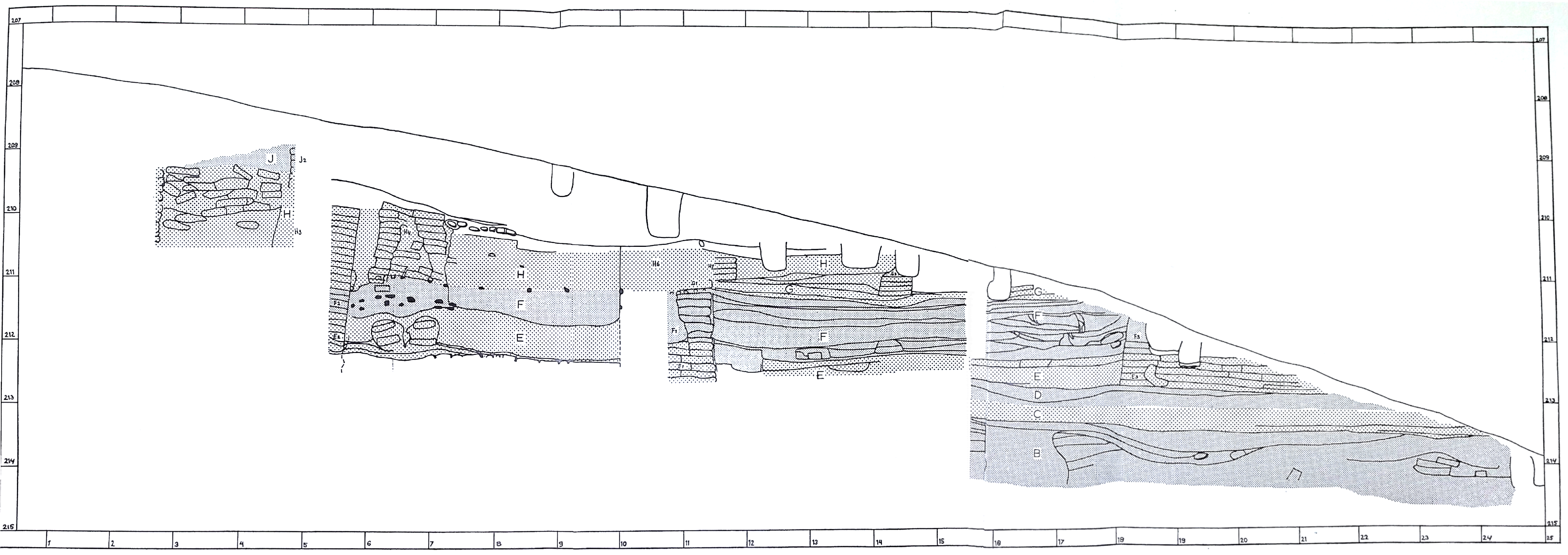
Excavating in Trench D, the 30-meter section trench, looking east
from the Tell Deir ‘Alla archive).
Halbertsma (2019) - Figure 7 Trench Layout
from Halbertsma (2019)
 Figure 7
Layout of the trenches of the 1960s excavations at Tell Deir 'Alla (Franken 1969, 13).
Halbertsma (2019)
In line with the Wheeler-Kenyon method, a grid system was used for the Franken excavations at Tell Deir ‘Alla. This grid system covered the entire site. The main datum line for the excavation made use of a Jordanian Government survey point on the tell’s summit, and ran across the summit of the mound in an East-West direction. The exact positioning of this grid system is detailed in Franken’s 1969 publication (Franken 1969, 15). The Jordanian Government triangulation point was also used as the fixed point from which heights for plans and sections were taken.
Initially, for the purpose of these exploratory excavations an area of 30 by 30 meters was laid out on the grid, along a 30-meter line. This area was subsequently divided into 10 by 10 meter squares. These squares were named alphabetically, in order of excavation. Each individual square was then subdivided into 5 by 5 meter units, increasing the stratigraphic control of excavations. Each of these separate units, henceforth sub-squares, was given a series number, which allowed for precise data collection. For example, square A consisted of sub-squares A100, A200, A300, and A400. Per trench excavation of the 5 by 5 sub-squares proceeded from the top of the slope in a westward direction, stepwise down the slope towards the north (see figure 6). This had as benefit that no baulks were left between the sub-squares, which otherwise would create deep pits. Rather, prior to the excavation of each new trench to the west, the west section of the old trench would be carefully planned, providing as Franken put it “a walking baulk” (Franken 1969, 12). An added benefit to this excavation strategy was that each terrace had an open northern end which greatly facilitated the removal of soil, and eliminated any safety issues related to high, and thus unstable, baulks.
... Initially Squares A to C were excavated, creating the first east-west oriented step. While these excavation trenches adhered to the above described configuration, Trench D deviated from this set. This trench was created to provide a north-south cross-section of the entire excavated area, together with Trench C. Initially, this Trench D was 6 meters wide, but later extended to the full 10 meters. Resultantly, Trench D was 20 by 10 meters, and with the east section of Trench C, provided a north-south section of the entire 30 meter stepped trench. Trenches were also extended north of Squares A and B. These new sub-squares were initially identified as belonging to trenches A and B (to be specific named A500, A600, B300 and B500). However, during the 1961 excavations the 5 meter extension of Trench A (A500, A600) was further excavated as F100 and F200. As a result, there is an overlap between Squares A and F, and both Squares A and B are larger than the originally intended 10 by 10 meters. Subsequently, the remaining part of the 30 by 30 grid was excavated further as Trenches E to G, and Trench L. Squares H and K were eastwards extensions, made in the 1962 excavation season (Franken 1969, 15). Letters I and J were not used for excavation squares. Unfortunately the rationale behind this decision is not clearly detailed in the 1969 publication. For other purposes, Franken does not make use of the letter I to avoid confusion with the Latin numeral for one (Franken 1969, 26). Possibly a similar reasoning is behind the omission of trenches I and J. In 1964 the original 30 by 30 meter excavation area was extended towards the north and east, to investigate a number of interesting Late Bronze Age structures touched upon in this area (Franken 1992). However, these extended areas, which contain the Late Bronze Age sanctuary, are not within the scope of the present research. As such they will not be discussed in further detail.
The ideal excavation strategy outlined by Franken in both his main publications of these early seasons of excavation as well as his later work describing the Late Bronze Age sanctuary, appears not to have been followed in all cases. The resultant plan of the excavated area therefore has an overall planned, but somewhat cobbled together appearance (see figure 7), apparently due to idiosyncratic choices made in the field. Unfortunately, several of these diversions are detailed neither in the published works nor the original field documentation, significantly complicating the understanding and systematic reinterpretation of the excavations in these areas.
- Figure 13 Map of Iron Age sites
in the Jordan Valley from Halbertsma (2019)
 Figure 13
Map of Iron Age sites discussed in this chapter
(after Van der Steen 1999, 179).
Halbertsma (2019)
The Jordan Valley itself, which forms the regional setting for the site of Tell Deir ‘Alla, shows most of the features described above associated with the 12th century BCE. There are sites that are abandoned, resettled, or destroyed. As this thesis’ aim is to explore this period specifically from the perspective of Tell Deir ‘Alla, the following chapter will provide a focussed overview of the archaeological evidence pertaining to the 12th century BCE in this region.
The Jordan Valley, which as mentioned in chapter 2 will cover the area from the southern end of the Sea of Galilee to the confluence of the Jordan and Zerqa Rivers, is mentioned as both the exception to and the rule of the larger narratives about the Late Bronze Age to Iron Age I. Contradictory statements about the character of the Jordan Valley in this period are numerous. Iron Age I sites in the Jordan Valley are, sometimes within the same volume, referred to as both “no more than the poor habitations of pastoralists and accompanying animal pens” (Gilboa 2014, 642) as well as seeming “to reflect a more prosperous lifestyle and [containing] a material culture that is oriented more toward the west than sites on the plateau” (Herr 2014, 649). This creates a confusing narrative, entirely dependent on which perspective is chosen for the specific passage.
In order to disentangle this confusing picture, a brief overview will be provided of the evidence gleaned from the archaeological record, which includes various survey projects that provide evidence for the settlement patterns of the Iron Age I in the Jordan Valley, as well as various archaeological excavations of sites with Iron Age I habitation layers.
Survey results
While typically travel reports from the Middle East are associated with 19th century travellers from the West, the Jordan Valley was already frequented and written about from at least as early as Idrisi (1154 CE), Yakut (1225 CE), and Ibn-Batuta (1326 CE) (Le Strange 1890, 31; Gibb 1958, 82-83). The first historical investigations of this area done by the 19th century Western travellers were usually focused on the identification of biblical sites (for a comprehensive list of all travellers' reports and surveys regarding the Jordan Valley, see Kaptijn 2009b).
The first wave of trained archaeologists who began identifying archaeological phenomena in the region, including Albright (1924-1925) and Glueck (1945-1949), began observing that a number of important changes in settlement patterns could be identified for the end of the Late Bronze Age and the beginning of the Iron Age I. Albright, for example, describes that the Jordan Valley must have been the first part of Palestine to be heavily developed, despitethe heat and "mosquito-breeding swamps" (Albright 1924-1925, 67). He noticed that the amount of Late Bronze Age sites in the Jordan Valley was significantly higher than in the hills, and remarks that most of them were abandoned in the Iron Age I, except for Tell Deir 'Alla (which he calls 'Succoth' in his publication) (Ibid., 68). A similar pattern is discussed by Glueck, who argues on the basis of his thorough survey of the Jordan Valley, that the Jordan Valley was not only one of the first settled areas (by which he meant urban settlements of the Bronze Age) of the Southern Levant, but also one of the richest parts of the entire area. He noted that 30 Iron Age I-II settlements were encountered in the area between the southern end of the Sea of Galilee, and the confluence of the Jordan and Zerqa Rivers (Glueck 1945-1949, 335).
While these important early archaeological surveys provided the foundations for the understanding of this period in the Jordan Valley, in more recent years additional large -scale surveys and the subsequent systematic reinterpretation of the existing survey data have allowed for the refinement of this image, such as the East Jordan Valley Survey (Ibrahim et al. 1976), and Eveline Van der Steen's survey during the 'Deir 'Alla Regional Project' (Ibrahim and Van der Kooij 1997; Van der Steen 2004).
The important work by Eveline Van der Steen, combining excavation and survey data of the Jordan Valley (e.g. Van der Steen 1996, 53), produced a picture which shows an increase in Iron Age I sites in comparison to the Late Bronze Age, especially in the Central Jordan Valley. However, the amount of Late Bronze Age sites in this area was already much larger than expected in comparison with other regions (Van der Steen 2004, 101). Additionally, her research identified patterns in the preferential location of Iron Age I sites in this region. Whereas the Late Bronze Age sites are found spread throughout the ghor area, the Iron Age I sites are most often located near a water source such as wadi's. As such, many Iron Age I sites are located along the Zerqa River, resulting in a higher density of sites located in the Central Jordan Valley in comparison to the surrounding areas, in particular the regions north of Tell es-Sa'idiyeh, and south of Tell Damiyah (Ibid.).
This picture is later substantiated by Eva Kaptijn's survey results from the large-scale 'Settling the Steppe' project (Kaptijn 2009b). This project focussed on creating a diachronic perspective of settlement strategies in the Central Jordan Valley, and like Van der Steen's work, shows that the Central Jordan Valley has the highest settlement density of Iron Age I sites in the entire Jordan Valley (Kaptijn 2014, 27). The increase is substantiated with a graph combining both site numbers and settlement density. There is an increase from 26 Late Bronze Age sites, to 37 Iron Age I sites, of which the densest cluster is in the Central Jordan Valley. Another interesting observation stemming from this project, was her theory that larger investments in irrigation strategies likely began somewhere during the Iron Age (Kaptijn 2009b, 410). This allowed for a higher percentage of crop yields, which might have resulted in population growth and subsequently more permanent settlements in the area. Unfortunately her survey conclusions don't differentiate between Iron Age I and Iron Age II, which might narrow this process down further.
Finally, a targeted site survey at several sites in the Central Jordan Valley was conducted by Lucas Petit (Petit 2009). This survey conducted targeted excavations for known Iron Age II sites, in order to gain a better understanding of the settlement dynamics of this period. This project succeeded in the identification of a process of oscillation of habitation at numerous sites, with rapid abandonment and resettling being the norm rather than the exception. Importantly, he observed that the Jordan Valley could be seen as a 'high risk, high reward' area, where the inhabitants had to maintain a manner of flexibility in their subsistence strategies in case of sudden internal or external threats. Petit postulates that this meant maintaining a communication network with the inhabitants of the highland areas, to have a place to fall back on when in need (Petit 2009, 229). While his study focussed on the Iron Age II, this model should be kept in mind for the study of the Iron Age I period, as during this period similar situations might have forced rapid changes in subsistence strategies for the inhabitants of the Central Jordan Valley.
In conclusion, the survey results of this area provide a picture of both change and continuity between the Late Bronze age and the following Iron Age I period. It is suggested that an increase in site density can be witnessed for this period, with a clear locational preference. These observations are particularly important with the political reconfiguration of the Iron Age I in mind, and provide a general, but essential framework in which to interpret the archaeological evidence deriving from the excavation of sites dated to this complex period in the history of the Jordan Valley and surrounding areas.
Excavations of Iron Age I layers
While surveys have indicated the presence of a large number of Iron Age I sites in Trans-Jordan, not much is known about the habitation at these sites. As mentioned above, in comparison to Cisjordan, excavations of Iron Age I layers in Transjordan are still quite rare. This holds true for the Jordan Valley, despite numerous long-term excavation projects in this region. These projects tended to focus on the Late Bronze Age or the Iron Age II, due to the picture of the Iron Age I being 'dark ages'. Seen as a period of decline, Iron Age I occupation often fell between the cracks. Nonetheless, at a modest number of sites layers dating to this period were excavated, giving us some more insights into the material culture and habitation in this period. With the published data several conclusions can be drawn about the Iron Age I in the Jordan Valley.
Of the 37 Jordan Valley sites identified as having habitation dating to the Iron Age I, only roughly 8 published excavations have touched upon those layers thusfar. These most notably include Tell Deir 'Alla, Tell el-Mazar, Tell es-Sa'idiyeh, Tell al-Hammeh, Tell Abu al-Kharaz, Beth Shean, Pella, and Tel Rehov. The most extensively excavated, and published, of these is Beth Shean, where substantial architecture has been uncovered. This site gives evidence of the presence of a large Egyptian garrison town at the site, during the 12th century BCE. It is estimated to have had a modest, but substantial community, with extraordinary richness portrayed in the Egyptian-style public buildings. The material found at this site reflects an ongoing engagement with Egypt, as well as an abundance of local Canaanite traditions. This is indicative of continuity of tradition, where not much changes throughout the 12th century. While several sites show similar patterns of continuation, such as Tel Rehov and to a lesser extent Tell al-Hammeh, Tell Deir 'Alla shows a highly different pattern. At this site the substantial Late Bronze Age sanctuary was destroyed in the first half of the 12th century, after which the site was briefly abandoned. It was then resettled, arguably by 'newcomers' (Franken 1969, 20-21) who came from a different area than the Jordan Valley. The layers belonging to these phases are associated with evidence for metalworking. This pattern of abandonment and resettling shows similarities with other sites, such as Tell Abu al-Kharaz. Particularly in the change in material culture do these similarities emerge, which could be a signal of the reconfiguration of interregional contacts mentioned above. The picture that emerges from the brief outline mentioned above, largely shows that two broad categories of characteristics can be discerned for the Iron Age I in the Jordan Valley, being that of abandonment, destruction, and resettlement, or 'change' in short, as opposed to continuation of local traditions. A third category will be added, being excavated Iron Age I sites with lack of or problematic data. Below a number of the main observations are discussed in more detail.
 Table 2
List of discussed archaeological sites with relevant phases as published, with corresponding dates BCE.
Halbertsma (2019)
 Figure 21
Idealized models for the major characteristics in cross-sectional view of the three types of flower structures present in the divergent-wrench fault zone.
- Negative
- Positive
- Hybrid
Huang and Liu (2017)
Flower structures are typical features of wrench fault zones.Identification is
based on differences in their internal structural architecture.Negative and Positive Flower Structures are widely known in Paleoseismology. Huang and Liu (2017) proposed a model of a 3rd type of flower structure - the Hybrid Flower Structure. All 3 types of flower structures are summarized below:
- Negative flower structures
- consists of a shallow synform bounded by upward spreading strands of a wrench fault with mostly normal separations
- occur in divergent-wrench fault zones where blocks move parallel to each other (i.e., pure strike-slip faults) and move with a component of divergence (i.e., divergent or transtensional wrench faults), especially easily occur in the regions of releasing bends and step overs along these wrench faults
- their presence indicates the combined effects of extensional and strike-slip motion.
- Positive flower structures
- consists of a shallow antiform displaced by upward diverging strands of a wrench fault with mostly reverse separations
- only occur in fault restraining bends and step overs where blocks move parallel to each other (i.e., pure strike-slip faults) and move with a component of convergence (i.e., convergent or transpressional wrench faults)
- Hybrid flower structures
- characterized by both antiforms and normal separations
- only occur in fault restraining bends and step overs
- can be considered as product of a kind of structural deformation typical of divergent-wrench zones
- is the result of the combined effects of extensional, compressional, and strike-slip strains under a locally appropriate compressional environment.
- The strain situation in it represents the transition stage that in between positive and negative flower structures.
- Kinematic and dynamic characteristics of the hybrid flower structures indicate the salient features of structural deformation in restraining bends and step overs along divergent-wrench faults, including the coexistence of three kinds of strains (i.e., compression, extension, and strike-slip) and synchronous presence of compressional (i.e., typical fault-bend fold) and extensional (normal faults) deformation in the same place.
- Location Map from
Van der Kooij (2006)
 Fig. 1
Map of Deir 'Alla region, based upon topographic map 1947
Van der Kooij (2006) - Jordan Valley Sites from
Ferry et al. (2011)
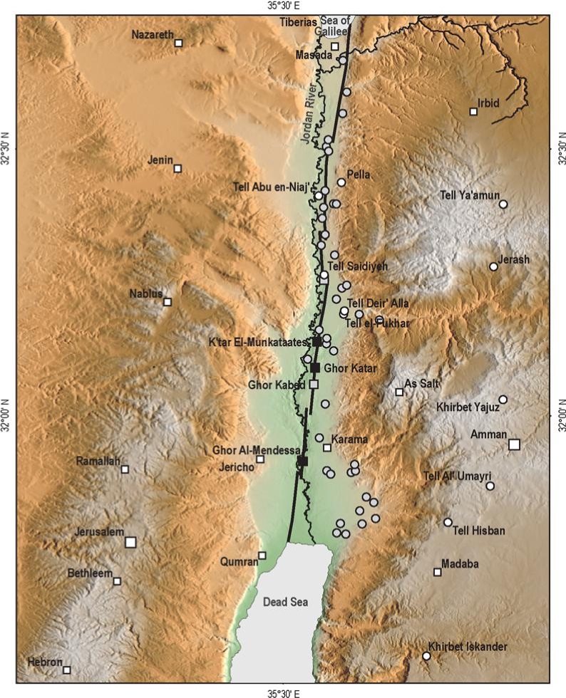 Figure 6
Archaeology of the Jordan Valley.
- White squares, main populated areas cited in historical documents
- white dots, archaeological sites visited and reappraised in this study
- gray dots are archaeological sites not studied here (lack of evidence and/or available literature) but of potential interest for future studies
- gray squares, paleoseismic sites
- black squares, geomorphological sites studied by Ferry et al. (2007)
Ferry et al. (2011)) - Fig. 2 Map of Iron Age I
sites in the Jordan Valley from Halbertsma (2019)
 Figure 2
Map of the Jordan Valley with Iron Age I sites mentioned in the thesis. The open circles are modern cities.
Halbertsma (2019) - Fig. 13 Map of Iron Age sites
in the Jordan Valley from Halbertsma (2019)
Figure 13
Map of Iron Age sites discussed in this chapter
(after Van der Steen 1999, 179).
Halbertsma (2019)
- Location Map from
Van der Kooij (2006)
Fig. 1
Map of Deir 'Alla region, based upon topographic map 1947
Van der Kooij (2006) - Jordan Valley Sites from
Ferry et al. (2011)
Figure 6
Archaeology of the Jordan Valley.
- White squares, main populated areas cited in historical documents
- white dots, archaeological sites visited and reappraised in this study
- gray dots are archaeological sites not studied here (lack of evidence and/or available literature) but of potential interest for future studies
- gray squares, paleoseismic sites
- black squares, geomorphological sites studied by Ferry et al. (2007)
Ferry et al. (2011)) - Fig. 2 Map of Iron Age I
sites in the Jordan Valley from Halbertsma (2019)
Figure 2
Map of the Jordan Valley with Iron Age I sites mentioned in the thesis. The open circles are modern cities.
Halbertsma (2019) - Fig. 13 Map of Iron Age sites
in the Jordan Valley from Halbertsma (2019)
Figure 13
Map of Iron Age sites discussed in this chapter
(after Van der Steen 1999, 179).
Halbertsma (2019)
- Fig. 2 Aerial view of
Tall Dayr ‘Allå from Kafafi (2009)
 Fig. 2
Aerial view of Tall Dayr ‘Allå
(after G. Van der Kooij 2006)
Kafafi (2009) - Fig. 4 Aerial view of
Tall Dayr ‘Allå from Kafafi (2023)
 Fig. 4
Horizontal excavation to obtain a plan of large buildings. Photo: Deir ‘Alla Expedition
Click on image to open in a new tab
Kafafi (2023) - Deir 'Alla in Google Earth
 Deir 'Alla
click on image to explore this site on a new tab in Google Earth
- Fig. 2 Aerial view of
Tall Dayr ‘Allå from Kafafi (2009)
Fig. 2
Aerial view of Tall Dayr ‘Allå
(after G. Van der Kooij 2006)
Kafafi (2009) - Fig. 4 Aerial view of
Tall Dayr ‘Allå from Kafafi (2023)
Fig. 4
Horizontal excavation to obtain a plan of large buildings. Photo: Deir ‘Alla Expedition
Click on image to open in a new tab
Kafafi (2023)
- Map of the mound and
excavation areas from Stern et al. (1993 v. 1)
 Tell Deir 'Alla: map of the mound and excavation areas
Stern et al. (1993 v. 1) - Site Plan with Excavation
Areas from Van der Kooij (2006)
 Fig. 2
Tell Deir 'Alla site plan: fields of Excavation
Van der Kooij (2006) - Fig. 1 - Map of the
mound and excavation areas from Kafafi (2023)
 Fig. 1
Contour Map and distribution of areas and squares at Tell Deir 'Alla
Photo: Deir 'Alla Expedition
Kafafi (2023) - Fig. 1 - Plan of Excavation
Trenches of the 1977-1978 seasons from Franken and Ibrahim (1978)
 Fig. 1
Tell Deir 'Alla Excavation Trenches
Franken and Ibrahim (1978)
- Map of the mound and
excavation areas from Stern et al. (1993 v. 1)
Tell Deir 'Alla: map of the mound and excavation areas
Stern et al. (1993 v. 1) - Site Plan with Excavation
Areas from Van der Kooij (2006)
Fig. 2
Tell Deir 'Alla site plan: fields of Excavation
Van der Kooij (2006) - Fig. 1 - Map of the
mound and excavation areas from Kafafi (2023)
Fig. 1
Contour Map and distribution of areas and squares at Tell Deir 'Alla
Photo: Deir 'Alla Expedition
Kafafi (2023) - Fig. 1 - Plan of Excavation
Trenches of the 1977-1978 seasons from Franken and Ibrahim (1978)
Fig. 1
Tell Deir 'Alla Excavation Trenches
Franken and Ibrahim (1978)
- Fig. 1 - Top plan of
the recovered architectural remains of the last stage of Phase IX (Area B) from Ibrahim and van der Kooij (1991)
 Fig. 1
Top plan of the recovered architectural remains of the last stage of Phase IX (Area B). Dotted lines refer to later disturbances (pits, erosion, egalisation)
Ibrahim and van der Kooij (1991) - Fig. 4 Section and plan
of Middle Bronze structures showing collapsed walls from Kafafi (2009)
 Fig. 4
Section drawing and plan of MB structures excavated 1976-1978
(after Franken and Ibrahim 1977-1978; Van der Kooij 2006)
Kafafi (2009) - Fig. 16 Plan and section
of excavated structures in Squares C/P 13 and 14 from Kafafi (2009)
 Fig. 16
Plan of the excavated structures in Squares C/P 13 and 14
(after Ibrahim and Van der Kooij 1997)
Kafafi (2009) - Fig. 82 West Section
of the excavated area from Franken (1969)
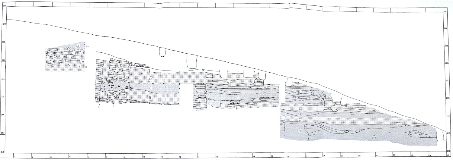 Fig. 82
West Section of the excavated area
Click on image to open a high res version in a new tab
Franken (1969)

- Fig. 1 - Top plan of
the recovered architectural remains of the last stage of Phase IX (Area B) from Ibrahim and van der Kooij (1991)
Fig. 1
Top plan of the recovered architectural remains of the last stage of Phase IX (Area B). Dotted lines refer to later disturbances (pits, erosion, egalisation)
Ibrahim and van der Kooij (1991) - Fig. 4 Section and plan
of Middle Bronze structures showing collapsed walls from Kafafi (2009)
Fig. 4
Section drawing and plan of MB structures excavated 1976-1978
(after Franken and Ibrahim 1977-1978; Van der Kooij 2006)
Kafafi (2009) - Fig. 16 Plan and section
of excavated structures in Squares C/P 13 and 14 from Kafafi (2009)
Fig. 16
Plan of the excavated structures in Squares C/P 13 and 14
(after Ibrahim and Van der Kooij 1997)
Kafafi (2009) - Fig. 82 West Section
of the excavated area from Franken (1969)
Fig. 82
West Section of the excavated area
Click on image to open a high res version in a new tab
Franken (1969)
- Fig. 19 Reconstruction drawing
of the ‘pillared house’ at Tall Dayr ‘Allå from Kafafi (2009)
 Fig. 19
Reconstruction of the ‘pillared house’ at Tall Dayr ‘Allå
(drawn by Ali Omari)
Kafafi (2009)
- Plate IVa Phase C Earthquake
Crack from Franken (1969)
 Plate IVa
Photograph of section 5.50/15.50-20, with earthquake crack, dated to phase C
Franken (1969) - Plate IVb Phase C Earthquake
Crack drawing from Franken (1969)
 Plate IVb
Section Drawing of section 5.50/15.50-20, with earthquake crack, dated to phase C
Franken (1969) - Plate Va Seismic displacements
(Phases A-D) from Franken (1969)
 Plate Va
A typical section through phases A-D courtyard deposits. Section to the left cf. fig. 3. The black burnt deposit clearly shows the disruptions by the shifting of the earth. In the centre: collapsed sides of a pit. Looking S.
Franken (1969) - Plate Vb Phase B Flower
Structure and burnt floors in Trench D from Franken (1969)
 Plate Vb
Trench D, looking s. Foreground phase A courtyards. Burnt floor of B 1 furnance. Top left the round tower, (wall K 13), cut through wall F (G) 8. Below the round tower remains of wall E 7 and phase D courtyards.
Franken (1969) - Figure 21 The same Phase B
Flower Structure and burnt floors in Trench D from Halbertsma (2019)
 Figure 21
Trench D100, looking south from D500. Visible is the heavily burnt surface of one of the installations (also visible in figure 18), and the various earthquake cracks complicating the stratigraphy in this part of the tell
(from the Tell Deir ‘Alla archive).
Halbertsma (2019) - Figure 6 Trench D Excavation
from Halbertsma (2019)
Figure 6
Excavating in Trench D, the 30-meter section trench, looking east
from the Tell Deir ‘Alla archive).
Halbertsma (2019) - Plate VIb Phase A Flower
Structure from Franken (1969)
 Plate VIb
Phase A accumulation over the red burnt L.B. ruins. Thick ash deposit (D 908), interrupted by pits and cracks.
Franken (1969) - Plate IXa Reed foundation and
cracks from Franken (1969)
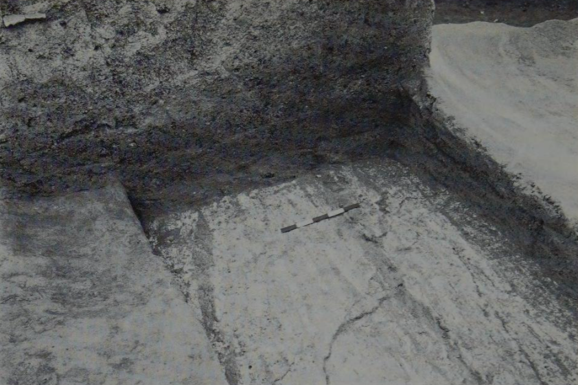 Plate IXa
Wall F 8 in section, showing the reed 'foundation' and cracks running through it
Franken (1969) - Plate IXb Bowed Walls
from Franken (1969)
 Plate IXb
Wall J 3 and wooden beam underneath. On the left wall J 1
Franken (1969) - Plate Xa Phase J road levels
from Franken (1969)
 Plate Xa
Phase J road levels, looking s. and stone pavement running along wall J 1
Franken (1969) - Plate Xb Phase K wall
dug into ruins of wall F8 from Franken (1969)
 Plate Xb
Phase K, wall K 13, the round tower dug into the ruins of wall F 8
Franken (1969) - Plate XIa Phase M wall
from Franken (1969)
 Plate XIa
Phase M, wall M5
Franken (1969) - Plate XIb Phase M cistern
from Franken (1969)
 Plate XIb
Phase M cistern, showing the circular pattern of the compressed fill in the horizontal section.
Franken (1969) - Plate XII Fill of Phase M
cistern from Franken (1969)
 Plate XII
Fill of Phase M cistern near the surface. In the centre, a wall of a house built on a clay deposit over the cistern with stone floor. In the burnt debris of this house, a mediaeval grave
Franken (1969) - Fig. 13 burned layer separating
the two Middle and Late Bronze Age phases from Kafafi (2009)
 Fig. 13
The burned layer, which separates the two phases
(photo by Yousef Zu‘bi)
Kafafi (2009) - Fig. 17 burned phase at the
south foot of the tall from Kafafi (2009)
 Fig. 17
General view of the burned phase at the south foot of the tall
(photo by Yousef Zu‘bi)
Kafafi (2009) - Fig. 18 four burned wooden
pillars and the stone pavement south of them from Kafafi (2009)
 Fig. 18
General view of the four burned wooden pillars and the stone pavement south of them
(photo by Yousef Zu‘bi)
Kafafi (2009) - Mudbrick photo by JW
 Mudbrick at the top of the mound at Deir Alla
Click on image to open in a new tab
Photo by Jefferson Williams - 29 Jan. 2026 - Fig. 5b Vertical excavation
at Tall Dayr ‘Allå from Kafafi (2023)
 Fig. 5b
Vertical excavation at Tell Deir ‘Alla. Photo: Yousef al-Zu’bi
Click on image to open in a new tab
Kafafi (2023) - Fig. 7 Stratigraphy of
Tall Dayr ‘Allå from Kafafi (2023)
 Fig. 7
Stratigraphy of Deir ‘Alla. Photo with permission of G. van Der Kooij and Z. Kafaf.
Click on image to open in a new tab
Kafafi (2023)
- Plate IVa Phase C Earthquake
Crack from Franken (1969)
Plate IVa
Photograph of section 5.50/15.50-20, with earthquake crack, dated to phase C
Franken (1969) - Plate IVb Phase C Earthquake
Crack drawing from Franken (1969)
Plate IVb
Section Drawing of section 5.50/15.50-20, with earthquake crack, dated to phase C
Franken (1969) - Plate Va Seismic displacements
(Phases A-D) from Franken (1969)
Plate Va
A typical section through phases A-D courtyard deposits. Section to the left cf. fig. 3. The black burnt deposit clearly shows the disruptions by the shifting of the earth. In the centre: collapsed sides of a pit. Looking S.
Franken (1969) - Plate Vb Phase B Flower
Structure and burnt floors in Trench D from Franken (1969)
Plate Vb
Trench D, looking s. Foreground phase A courtyards. Burnt floor of B 1 furnance. Top left the round tower, (wall K 13), cut through wall F (G) 8. Below the round tower remains of wall E 7 and phase D courtyards.
Franken (1969) - Figure 21 The same Phase B
Flower Structure and burnt floors in Trench D from Halbertsma (2019)
Figure 21
Trench D100, looking south from D500. Visible is the heavily burnt surface of one of the installations (also visible in figure 18), and the various earthquake cracks complicating the stratigraphy in this part of the tell
(from the Tell Deir ‘Alla archive).
Halbertsma (2019) - Figure 6 Trench D Excavation
from Halbertsma (2019)
Figure 6
Excavating in Trench D, the 30-meter section trench, looking east
from the Tell Deir ‘Alla archive).
Halbertsma (2019) - Plate VIb Phase A Flower
Structure from Franken (1969)
Plate VIb
Phase A accumulation over the red burnt L.B. ruins. Thick ash deposit (D 908), interrupted by pits and cracks.
Franken (1969) - Plate IXa Reed foundation and
cracks from Franken (1969)
Plate IXa
Wall F 8 in section, showing the reed 'foundation' and cracks running through it
Franken (1969) - Plate IXb Bowed Walls
from Franken (1969)
Plate IXb
Wall J 3 and wooden beam underneath. On the left wall J 1
Franken (1969) - Plate Xa Phase J road levels
from Franken (1969)
Plate Xa
Phase J road levels, looking s. and stone pavement running along wall J 1
Franken (1969) - Plate Xb Phase K wall
dug into ruins of wall F8 from Franken (1969)
Plate Xb
Phase K, wall K 13, the round tower dug into the ruins of wall F 8
Franken (1969) - Plate XIa Phase M wall
from Franken (1969)
Plate XIa
Phase M, wall M5
Franken (1969) - Plate XIb Phase M cistern
from Franken (1969)
Plate XIb
Phase M cistern, showing the circular pattern of the compressed fill in the horizontal section.
Franken (1969) - Plate XII Fill of Phase M
cistern from Franken (1969)
Plate XII
Fill of Phase M cistern near the surface. In the centre, a wall of a house built on a clay deposit over the cistern with stone floor. In the burnt debris of this house, a mediaeval grave
Franken (1969) - Fig. 13 burned layer separating
the two Middle and Late Bronze Age phases from Kafafi (2009)
Fig. 13
The burned layer, which separates the two phases
(photo by Yousef Zu‘bi)
Kafafi (2009) - Fig. 17 burned phase at the
south foot of the tall from Kafafi (2009)
Fig. 17
General view of the burned phase at the south foot of the tall
(photo by Yousef Zu‘bi)
Kafafi (2009) - Fig. 18 four burned wooden
pillars and the stone pavement south of them from Kafafi (2009)
Fig. 18
General view of the four burned wooden pillars and the stone pavement south of them
(photo by Yousef Zu‘bi)
Kafafi (2009) - Mudbrick photo by JW
Mudbrick at the top of the mound at Deir Alla
Click on image to open in a new tab
Photo by Jefferson Williams - 29 Jan. 2026 - Fig. 5b Vertical excavation
at Tall Dayr ‘Allå from Kafafi (2023)
Fig. 5b
Vertical excavation at Tell Deir ‘Alla. Photo: Yousef al-Zu’bi
Click on image to open in a new tab
Kafafi (2023) - Fig. 7 Stratigraphy of
Tall Dayr ‘Allå from Kafafi (2023)
Fig. 7
Stratigraphy of Deir ‘Alla. Photo with permission of G. van Der Kooij and Z. Kafaf.
Click on image to open in a new tab
Kafafi (2023)
 Fig. 1
Chronological table of the periods represented at Tell Der 'Alla
(after van der Kooij 2009)
Kafafi and van der Kooij (2013)
Franken published a list of deposits relating to Phase B in the 1969 publication, which is summarised below for Trench D
- from Halbertsma (2019)
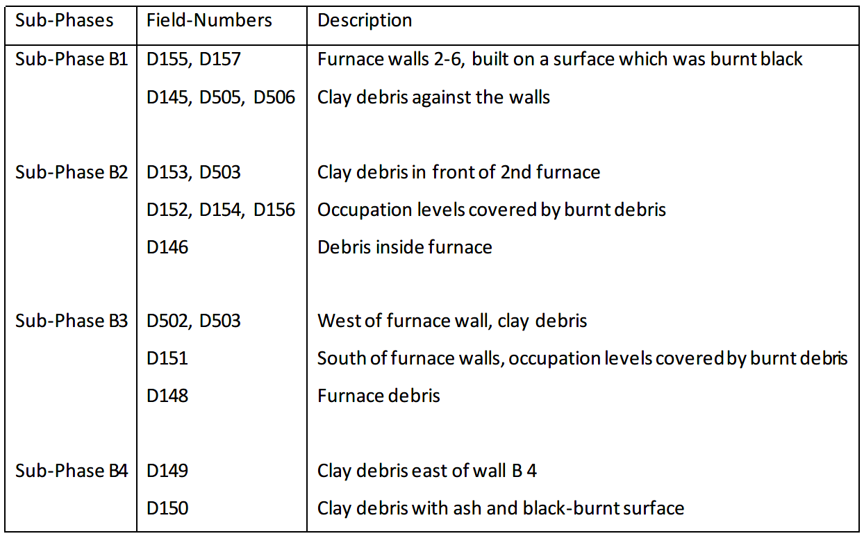 Table 3
Subdivision of phases with corresponding field-numbers from Trench D100 and D500
(after Franken 1969, 39-40).
Halbertsma (2019)
- from Van der Kooij (2006)
 Table 2
Excavation and stratigraphic results: Phases A–G3 (from squares “F and L” in the west to “P600” in the east)
Footnote 3 Not all parts of the excavated field had stratigraphic connections through all phases.
Van der Kooij (2006)
- from Van der Kooij (2006)
Preliminary general phasing: an attempt to synchronize all fields’ phases9
Footnote 9 - The phases are distinguished according to features of partial or full collapse and rebuilding, as well as separate courtyard accumulations; a more limited rebuilding is taken as a sub-phase. Long term desertion of the site is not clearly noted. Bold types are used for major building phases, which may be synchronous. These distinctions are basically local, but four of them are indicated as multi-local or even general which is indicated by continuing horizontal lines in the table.
click on image to open in a new tab
Van der Kooij (2006)
 Table 5
Original temple sequence (Franken 1992) and the re-evaluated phasing based on the 2022 season, including characteristics and preliminary dating conclusions
click on image to open in a new tab
Halbertsma et al. (2026)
 Table 3
Botanical samples of which a selection was used for radiocarbon dating
click on image to open in a new tab
Halbertsma et al. (2026)
 Table 4
Radiocarbon dates of the five submitted samples (IntCal20: Reimer et al. 2020) and OxCal 4.4.4 (Bronk Ramsey 2021)
click on image to open in a new tab
Halbertsma et al. (2026)
 Figure 19
Radiocarbon dates in stratigraphical sequence (unmodelled) with historical date of Tausret’s rule included (OxCal 4.4.4) and a Bayesian chronological model of the temple sequence for Phases E and F (Bronk Ramsey 2021; Reimer et al. 2020).
click on image to open in a new tab
Halbertsma et al. (2026)
- from Fall et al. (2023)
 Table 1
Traditional and revised Early and Middle Bronze Age chronologies for the Southern Levant. (Traditional chronology based on Dever 1992; Levy 1995:fig. 3; revised chronology based on Regev et al. 2012; Fall et al. 2021; Höflmayer and Manning 2022.)
Fall et al. (2023)
- from Franken (1969:40-42)
- Fig. 4 - Plan of Phase A
from Franken (1969)
 Fig. 4
Plan of Phase A
Franken (1969) - List of Deposits of Phase A
from Franken (1969)
 List of Deposits of Phase A
Franken (1969)
The plan of phase A shows a depression between the ruins of the L.B. [Late Bronze] cella, which was built on a brick platform, on the east side and the ruins of what seem to have been two towers on the west. The northern tower belonged to the second re-building period of the sanctuary after its total destruction and the southern tower is the third and last attempt to rebuild. From the stratigraphic evidence which is available it is clear that the attempts to rebuild did not last for more than a few years at the most.
Between these ruins lay a depression of c. two metres depth, which was tilled with the earliest I.A. [Iron Age] deposits, consisting of occupation levels with thick deposits and streaks of burnt material washed from the ruined L.B. buildings. These wash deposits penetrate like wedges between the occupation levels and partly make up these levels. Besides this, there is all the earth excavated from the phase A pits made by the new occupants. Practically all the lower deposits of phase A consist, therefore, of L.B. material. This changed after the L.B. ruins were completely levelled off.
At an early stage the depression was used to store brushwood, obviously fuel for ovens or furnaces, which caught fire leaving a deposit of white and pink coloured ash in places as much as 20 cms. thick. (P1. VI.b) Similar fires occurred in later phases, burning over the whole width of the excavated area. As a result of this fire the ruins of the latest L.B. tower caught fire and burned from the level on which the fuel had been piled up. Though the heat did not penetrate much below the ground level, the remaining bricks above the surface were all thoroughly burned red. This caused a new series of streaks of burnt L.B. clay to wash down over the I.A. deposits. This observation confirms that once a certain degree of heat is generated in a mud brick wall, the wall itself conducts the heat and burns right through. At the same time it shows that the tower cannot have been a ruin for a long time, as its bricks still contained enough straw and air to feed the flames. From the section through this tower it is clear that the burnt bricks are higher than the unburned bricks already buried under the surface, and since compressed by the influence of moisture and pressure.
The dotted line on the map, running east-west from 30.50/28 to 0.50/30 indicates the top of a crack which slopes down in a northerly direction. On both sides of this crack the difference in height of the same deposits is about 0.60 m. Deposits that reach the surface of the tell on the south side of the crack continue again on the north side.
Structures
A stone pavement not connected with any walls was found in sq. E (619), immediately on the top of burnt walls from the first rebuilding of the L.B. sanctuary. (Pl. VIa) It was probably part of the metal-industry installations and contained several large fragments of stone bowls, which may have originally belonged to the L.B. sanctuary. The scanty traces of two walls in sq. C(204) cannot be interpreted as either house walls or as an industrial installation. The division between phases A and B falls later, with the building of the furnaces in sq. D. The clay for the bricks of these and many of the later walls was taken from the slopes of the mound, for they contain many burned clay particles which colour them in light reddish shades. These walls decomposed easily under the influence of the rain and the winds and they sometimes form an almost indistinguishable part of the debris in which they are buried. Here right from the beginning is the typical feature that nowhere in the I.A. were walls built on stone foundations. They were always built on top of the existing surface.
From a sounding in 1964 (not published here) east of the excavated area, brick constructions exist with heavy walls. They could either form part of the industrial works oft he new occupants of the mound or may belong to a structure similar to the sanctuary but on a much smaller scale; thus carrying on the tradition of a holy place.
A puzzling feature arc the many pits that were dug in this period. Apart from a few pits that may have been dug for treasure hunting in the area of the ruined cella, these pits usually have a typical "pear" shape in section, and their depth is sometimes over 2 m. One pit is brick lined and not pear-shaped. There must be some connection with the industry. On the plan only those pits that could be certainly attributed to phase A are drawn. Because of their depth a great number of pits near the northern limit (the slope) cannot be stratigraphically distributed over the phases. Further, the phase A deposits have been badly disturbed by many phase B pits penetrating into the earlier levels. These disturbances have not been indicated on the plan.
It is clear that a good deal of the pottery found in phase A must come from the earlier structures. Although the earliest I.A. pottery is distinguishable from the latest pottery from the sanctuary, the phase A pottery has not been used for our statistical studies. Pottery from sq. D. dates from the time after the complete levelling off of the L.B. ruins and is therefore more reliable. By the end of phase A the surface slopes from east to west, but the accumulation in sq. D. does not seem to begin before the great fire in phase A. The sq. D. deposits have been divided in 3 so that when excavation can be extended to the east and south, the new stratigraphic evidence can be properly fitted into the present picture.
- from Franken (1969:44-46)
- Fig. 10 - Plan of Phase E
from Franken (1969)
 Fig. 10
Plan of Phase E
Franken (1969) - List of Deposits of Phase E
from Franken (1969)
 List of Deposits of Phase E
Franken (1969)
A considerable amount of building started in phase E. A substantial building (walls E1 and E2) appears, only a small portion of which was traced in phase E (cf. phase H). The width of wall E1 is 1.40 m. This building had a long history and was rebuilt in phase H. The original floor consisted of day. A curious structure was found between the two walls, looking as if a wall had been folded double. A large amount of organic material (straw?) was found in the fill, but no pottery. North of wall E1 an accumulation of wind-blown material was found, which also piled up against wall E4. Walls E3 and 4 and probably E5 form another building. Wall E4 was in a very bad state of preservation in square E 300. Wall E5 was built on the remains of wall D1. In this wall a doorway was found, which was blocked with bricks. A later pit had destroyed part of the remains of this wall. Wall E4 is slightly later than wall E3. Two walls, E9 and E10 became visible in the east section of square A but have not been further excavated. They appear to be buried in their own clay and slope down to the west. South of wall E9 street levels appear. Between walls E5 and B6 a series of street levels, covered by a thick deposit of clay and wind-blown material was found. Wall E6 survived only in a few traces. No connection between this wall and wall E7 could be found. East of wall E6 there was again a series of street levels or occupation levels, alternating with ashy, burnt and unburnt clay deposits. These deposits also stretch right along the south side of wall E7. This wall was found in an almost completely decayed state, reduced to a heap of clay with bricks in a regular position recognizable only in square D. The wall seems to have run parallel to a very substantial wall E8, which was so near the surface that the bricks had decomposed. There was no evidence that walls E7 and 8 formed a casemate wall. They were however certainly built on the same surface. The space between these walls was filled with clay rubble. From the present evidence they cannot be interpreted as town walls. They lasted only through phase E. The position of these walls illustrates what has been said in the introduction about the wind erosion working on the north west corner of the tell.
Both from the pottery evidence and from the structural remains of this phase it be-comes clear that a new type of occupation of the mound begins with phase E. Too little is known yet about the nature of the large building on the west side to ascertain its purpose, but a store house is possible. That progress was slow and that there were still large open spaces is shown by the fact that wind-blown material still accumulated in this period against the walls, a process discussed in phase D.
We have found no indications that the tell was actually abandoned for any length of time between phases D and E. Brick wall D1 was still partly standing when the new building activities started. Wind-blown material, especially of the kind found all over the surface of the tell in the semi-nomadic period, accumulates quickly. (A basket boy emptying his basket on the top of the dump during an eastern storm could see the contents of his basket being blown as a dust cloud to the west). There is no evidence that a later phase of the "nomadic" period was eroded away from the excavated area before the new building activities started. (For the pottery evidence, see Part II.)
We assume, therefore, that a group of villagers took possession of the mound for a new settlement. This must have happened about the middle of the 12th century B.C. or slightly later. Their pottery tradition was certainly related to that of the "semi-nomads" but there are some characteristic differences. It is certainly possible that the semi-nomads continued their activities in the vicinity, leaving the mound to the villagers. There are no indications of any hostilities having taken place between the two groups.
Plate VIb from Franken (1969)
shows what looks like seismic deformation of Late Bronze Age Deposits which were burned and then overlain
by the Iron Age I deposits of Phase A.
Raphael and Agnon (2018:775), while citing
Franken (1992:6-9), may refer to this as a Phase E earthquake in LB II (Late Bronze II).
Kafafi and van der Kooij (2013:Fig. 1) indicate that Phase E ended ~1200 BCE
in LB II right before the start of the Iron Age.
Plate VIbPhase A accumulation over the red burnt L.B. ruins. Thick ash deposit (D 908), interrupted by pits and cracks.
Franken (1969)
- Fig. 13 burned layer separating
the two Middle and Late Bronze Age phases from Kafafi (2009)
Fig. 13
The burned layer, which separates the two phases
(photo by Yousef Zu‘bi)
Kafafi (2009) - Fig. 16 Plan and section
of excavated structures in Squares C/P 13 and 14 from Kafafi (2009)
Fig. 16
Plan of the excavated structures in Squares C/P 13 and 14
(after Ibrahim and Van der Kooij 1997)
Kafafi (2009) - Fig. 17 burned phase at the
south foot of the tall from Kafafi (2009)
Fig. 17
General view of the burned phase at the south foot of the tall
(photo by Yousef Zu‘bi)
Kafafi (2009) - Fig. 18 four burned wooden
pillars and the stone pavement south of them from Kafafi (2009)
Fig. 18
General view of the four burned wooden pillars and the stone pavement south of them
(photo by Yousef Zu‘bi)
Kafafi (2009) - Fig. 19 Reconstruction drawing
of the ‘pillared house’ at Tall Dayr ‘Allå from Kafafi (2009)
Fig. 19
Reconstruction of the ‘pillared house’ at Tall Dayr ‘Allå
(drawn by Ali Omari)
Kafafi (2009)
- Figure 21 Phase B Flower Structure
and burnt surface from Halbertsma (2019)
Figure 21
Trench D100, looking south from D500. Visible is the heavily burnt surface of one of the installations (also visible in figure 18), and the various earthquake cracks complicating the stratigraphy in this part of the tell
JW: Note the Flower Structure
(from the Tell Deir ‘Alla archive).
Halbertsma (2019) - Idealized Models of Flower Structures
from Huang and Liu (2017)
Figure 21
Idealized models for the major characteristics in cross-sectional view of the three types of flower structures present in the divergent-wrench fault zone.
- Negative
- Positive
- Hybrid
Huang and Liu (2017)
Figure 21Idealized models for the major characteristics in cross-sectional view of the three types of flower structures present in the divergent-wrench fault zone.
- Negative
- Positive
- Hybrid
Huang and Liu (2017)
Flower structures are typical features of wrench fault zones.Identification is
based on differences in their internal structural architecture.Negative and Positive Flower Structures are widely known in Paleoseismology. Huang and Liu (2017) proposed a model of a 3rd type of flower structure - the Hybrid Flower Structure. All 3 types of flower structures are summarized below:
- Negative flower structures
- consists of a shallow synform bounded by upward spreading strands of a wrench fault with mostly normal separations
- occur in divergent-wrench fault zones where blocks move parallel to each other (i.e., pure strike-slip faults) and move with a component of divergence (i.e., divergent or transtensional wrench faults), especially easily occur in the regions of releasing bends and step overs along these wrench faults
- their presence indicates the combined effects of extensional and strike-slip motion.
- Positive flower structures
- consists of a shallow antiform displaced by upward diverging strands of a wrench fault with mostly reverse separations
- only occur in fault restraining bends and step overs where blocks move parallel to each other (i.e., pure strike-slip faults) and move with a component of convergence (i.e., convergent or transpressional wrench faults)
- Hybrid flower structures
- characterized by both antiforms and normal separations
- only occur in fault restraining bends and step overs
- can be considered as product of a kind of structural deformation typical of divergent-wrench zones
- is the result of the combined effects of extensional, compressional, and strike-slip strains under a locally appropriate compressional environment.
- The strain situation in it represents the transition stage that in between positive and negative flower structures.
- Kinematic and dynamic characteristics of the hybrid flower structures indicate the salient features of structural deformation in restraining bends and step overs along divergent-wrench faults, including the coexistence of three kinds of strains (i.e., compression, extension, and strike-slip) and synchronous presence of compressional (i.e., typical fault-bend fold) and extensional (normal faults) deformation in the same place.
- from Halbertsma (2019)
- Figure 18 Black burnt surface of
an entry to one of the installations from Halbertsma (2019)
 Figure 18
Entry to one of the installations, most likely D148, looking north. Note the black-burnt surface
(from the Tell Deir ‘Alla archive).
Halbertsma (2019) - Table 3 Phase B subdivisions
from Halbertsma (2019)
Table 3
Subdivision of phases with corresponding field-numbers from Trench D100 and D500
(after Franken 1969, 39-40).
Halbertsma (2019) - Figure 21 Phase B Flower Structure
and burnt surface from Halbertsma (2019)
Figure 21
Trench D100, looking south from D500. Visible is the heavily burnt surface of one of the installations (also visible in figure 18), and the various earthquake cracks complicating the stratigraphy in this part of the tell
JW: Note the Flower Structure
(from the Tell Deir ‘Alla archive).
Halbertsma (2019) - Plate Vb Phase B Flower Structure
and burnt floors in Trench D from Franken (1969)
Plate Vb
Trench D, looking s. Foreground phase A courtyards. Burnt floor of B 1 furnance. Top left the round tower, (wall K 13), cut through wall F (G) 8. Below the round tower remains of wall E 7 and phase D courtyards.
Franken (1969) - Figure 6 Trench D Excavation
from Halbertsma (2019)
Figure 6
Excavating in Trench D, the 30-meter section trench, looking east
from the Tell Deir ‘Alla archive).
Halbertsma (2019) - Idealized Models of Flower Structures
from Huang and Liu (2017)
Figure 21
Idealized models for the major characteristics in cross-sectional view of the three types of flower structures present in the divergent-wrench fault zone.
- Negative
- Positive
- Hybrid
Huang and Liu (2017) - Figure 22 Section DIIb,
between Squares D100 and D500 from Halbertsma (2019)
 Figure 22
Section DIIb, between Squares D100 and D500. Colours correspond to the different Sub-Phases in the Harris matrix (see figure 23).
Halbertsma (2019) - Figure 23 Harris matrix
of the Phase B installations from Halbertsma (2019)
 Figure 23
Harris matrix of the Phase B installations. The various Sub-phases are described as B1 to B5, also visible section DIIb (see figure 22).
Halbertsma (2019) - Table 4 List of stratigraphic
units visible on section DIIb from Halbertsma (2019)
 Table 4
List of stratigraphic units visible on section DIIb (see figure 22), and used in the Harris matrix (see figure 23)
Halbertsma (2019) - Figure 24 Part of section DI
from Halbertsma (2019)
 Figure 24
Part of section DI.
Halbertsma (2019) - Figure 25 Part of section DIII
from Halbertsma (2019)
 Figure 25
Part of section DIII.
Halbertsma (2019) - Figure 26 Sub-phase 2
installation floor from Halbertsma (2019)
 Figure 26
Top-Plan D3, showing the earliest recognised installation floor, corresponding with Sub-phase 2.
Halbertsma (2019) - Figure 27 Sub-phase 5
installation from Halbertsma (2019)
 Figure 27
Top-plan D1, showing the latest installation (D148) corresponding with Sub-phase 5, along with Franken's proposed outlines of the earlier installations. Note the 'air-ducts' in the north-east corner, protruding from the mudbrick wall, and the upright mudbricks forming niches on the eastern side.
Halbertsma (2019) - Figure 31 Upright mudbricks
creating niches in D148 from Halbertsma (2019)
 Figure 31
Upright mudbricks creating niches in D148. Looking west
(from the Tell Deir ‘Alla archive).
Halbertsma (2019)
- Figure 18 Black burnt surface of
an entry to one of the installations from Halbertsma (2019)
Figure 18
Entry to one of the installations, most likely D148, looking north. Note the black-burnt surface
(from the Tell Deir ‘Alla archive).
Halbertsma (2019) - Table 3 Phase B subdivisions
from Halbertsma (2019)
Table 3
Subdivision of phases with corresponding field-numbers from Trench D100 and D500
(after Franken 1969, 39-40).
Halbertsma (2019) - Figure 21 Phase B Flower Structure
and burnt surface from Halbertsma (2019)
Figure 21
Trench D100, looking south from D500. Visible is the heavily burnt surface of one of the installations (also visible in figure 18), and the various earthquake cracks complicating the stratigraphy in this part of the tell
JW: Note the Flower Structure
(from the Tell Deir ‘Alla archive).
Halbertsma (2019) - Plate Vb Phase B Flower Structure
and burnt floors in Trench D from Franken (1969)
Plate Vb
Trench D, looking s. Foreground phase A courtyards. Burnt floor of B 1 furnance. Top left the round tower, (wall K 13), cut through wall F (G) 8. Below the round tower remains of wall E 7 and phase D courtyards.
Franken (1969) - Figure 6 Trench D Excavation
from Halbertsma (2019)
Figure 6
Excavating in Trench D, the 30-meter section trench, looking east
from the Tell Deir ‘Alla archive).
Halbertsma (2019) - Idealized Models of Flower Structures
from Huang and Liu (2017)
Figure 21
Idealized models for the major characteristics in cross-sectional view of the three types of flower structures present in the divergent-wrench fault zone.
- Negative
- Positive
- Hybrid
Huang and Liu (2017) - Figure 22 Section DIIb,
between Squares D100 and D500 from Halbertsma (2019)
Figure 22
Section DIIb, between Squares D100 and D500. Colours correspond to the different Sub-Phases in the Harris matrix (see figure 23).
Halbertsma (2019) - Figure 23 Harris matrix
of the Phase B installations from Halbertsma (2019)
Figure 23
Harris matrix of the Phase B installations. The various Sub-phases are described as B1 to B5, also visible section DIIb (see figure 22).
Halbertsma (2019) - Table 4 List of stratigraphic
units visible on section DIIb from Halbertsma (2019)
Table 4
List of stratigraphic units visible on section DIIb (see figure 22), and used in the Harris matrix (see figure 23)
Halbertsma (2019) - Figure 24 Part of section DI
from Halbertsma (2019)
Figure 24
Part of section DI.
Halbertsma (2019) - Figure 25 Part of section DIII
from Halbertsma (2019)
Figure 25
Part of section DIII.
Halbertsma (2019) - Figure 26 Sub-phase 2
installation floor from Halbertsma (2019)
Figure 26
Top-Plan D3, showing the earliest recognised installation floor, corresponding with Sub-phase 2.
Halbertsma (2019) - Figure 27 Sub-phase 5
installation from Halbertsma (2019)
Figure 27
Top-plan D1, showing the latest installation (D148) corresponding with Sub-phase 5, along with Franken's proposed outlines of the earlier installations. Note the 'air-ducts' in the north-east corner, protruding from the mudbrick wall, and the upright mudbricks forming niches on the eastern side.
Halbertsma (2019) - Figure 31 Upright mudbricks
creating niches in D148 from Halbertsma (2019)
Figure 31
Upright mudbricks creating niches in D148. Looking west
(from the Tell Deir ‘Alla archive).
Halbertsma (2019)
... There appeared to not have been a permanent village until after the Iron Age I. During the Late Bronze Age, the site seemed reserved for a single large sanctuary, with no ordinary settlement of any kind.
...No human remains were found in the layers dating to the Iron Age I. ...
4.2 Stratigraphic analysis of the Phase B excavation trenches
A starting point had to be defined to begin working with the Tell Deir 'Alla archive
and explore its potential. To this end a well-defined context had to be chosen,
small enough to allow the author to investigate it in the span of this MPhil
research, and significant enough to contribute to the current scientific discourses.
The Phase B installations met these criteria, and therefore were chosen as a 'pilot study'
for the current research. As the Phase B installations fall largely within two trenches,
Trenches D100 and D500, and the overall chronology of Phase B is most clearly represented
here, this provided a well-defined and manageable starting point. As mentioned above, the
relevance of these installations for the Iron Age I Jordan Valley made these all the more
appealing. While they are discussed in the literature, their archaeological contexts haven't
been fully published yet. While it still proved a substantial task to get fully familiarised
with the excavation system and the documentation, the selection of the Phase B installations
as the focal point of the current research and the limiting of the analysis of the stratigraphy
to these two trenches, provided a realistic starting point for working with the Tell Deir 'Alla archive.
In this section a detailed analysis of the stratigraphy of the Phase B installations will be provided.
As mentioned above, the preceding Phase A is very clearly visible in the stratigraphy. It appears as
a dense sequence of wash layers, as described by Franken. In the subsequent period many changes occur,
as suddenly various phases of building activities can be observed. Franken already reflected this in a
change of stratigraphic phase, ascribing the subsequent phase as Phase B. This division still holds true,
which is why it will be adopted in this thesis.
4.2.1 — Data from the archive
While nothing is guaranteed when working with old archives, a surprising amount of data concerning the
Phase B installations could be retrieved. Apparently, Franken had already realised in the field how important
the Phase B installations would become, as these features are covered relatively generously in the archive.
Numerous photos document the features, as well as various drawings, sections, and sketches in the fieldnotes
by Franken himself. Apart from the usual drawings, which were made for every excavated square, smaller and
targeted top-plans and cross-sections were also drawn. Below is a summary of what the archive contains
regarding the Phase B installations.
Sections
As was usual for every excavated Trench, all the sections in the sub-squares of
D100 and D500 were drawn. However, due to the steep slope towards the north of
trench D no north-section was made for sub-square D100. This was not unusual,
as Franken applied the 'walking baulk' method described in chapter 2. Instead,
the south section from adjoining square D500 is referred to, as an 'inverted'
north section for square D100, and is documented as drawing Dllb (see figure 22).
The regular section drawings for sub-square D100 are DI (the large eastern section
covering the entirety of Trench D, see figure 9 and figure 24), DII a (the south section),
and DIII (the west section, see figure 25). Apart from the regular section drawings,
which were made for every excavated square, smaller cross-sections of soundings made
to clarify the stratigraphy were also drawn.
Top-plans
As with the section drawings, Trench D100 had several major top-plans, being D1, D2, D3, and D4.
These top-plans all portray the Phase B installations, in various stages of the excavation process.
D4, for example, shows the situation when the installation are encountered. D2 shows remains of the
first use of Phase B, as well as some Late Bronze Age architecture. D3 shows the first installation
(see figure 26), and D1 the latest (see figure 27). Other than these drawings, which were made in
the field, summarizing drawings were made combining all of the top-plans. In these the furnaces
are plotted one atop the other. Other than these drawings, the archive also contained several
smaller top-plans from Phase B. These are often difficult to trace back to their stratigraphic
location, as not all of them contain clear measurements forthe grid system.
Fieldnotes
The fieldnotes relating to Trenches D100 and D500 are in one single notebook.
The fieldnotes were written by Prof Dr H. Brunsting, a Dutch archaeologist,
who was the sole supervisor of the excavations of Phase B in Trench D (see figure 19).
The fieldnotes pertaining to Phase B were written between 8 February and 27 March 1960,
indicating it was excavated over the period of roughly a month and a half. The fieldnotes
vary in quality and content, with certain deposits being described in much greater detail
than others. References are made to the section drawings and top-plans, and certain sketches
and excavation strategies explain decisions made in the field. The overwhelming majority of
the fieldnotes, however, describe very briefly what work was done in what area of the trench.
This leaves out descriptions of the deposits that were excavated, as well as the precise
location of many finds, complicating stratigraphic analyses.
... Photographs
Thus far a total of 55 separate photo’s portraying information from Phase B in Trench D have
been recovered. They vary in quality, and it is apparent that several times multiple
photographs were shot of the same feature at more or less the same angle. These were likely
made with the ‘Miranda’ camera (see figure 18), which often required taking several of the
same shots to ensure a positive outcome when processing the negatives. The majority of these
photographs capture one or more aspects of the Phase B installations, indicating these
were a clear priority for the excavators.
... 4.2.2 – Franken’s publication of Phase B
In the 1969 publication, Franken published his stratigraphic interpretation of Phase B
(Franken 1969, 36-40). While he published several top-plans, as well as a cross section of the
installations, these were summaries of the actual drawings. Franken’s main goal for the 1969
publication was to publish the pottery chronology, which should be kept in mind when interpreting
the stratigraphy on that basis. He published the walls with different numbers than the ones used in
the field, but did keep the original deposit numbers. This makes retracing his steps somewhat
complicated, as the variety of numbers in the 1969 publication do not reflect the documentation
in the archive, which is less detailed.
Franken identified 5 sub-phases in Phase B, based on the stratigraphy. These cover the entire period
that the furnaces were in use, the first of which he postulates was likely built in the very last part
of Phase A. He notes that the east, west, and south walls of the installations form the installations'
shape, which stays more or less the samethroughout Phase B. Franken recognised three separate installations,
but the first one was dug through a possible earlier one constructed in Phase A. As such, a sequence of 4
installations was recognised, all constructed one atop the other. The exact outline and location of the
phase A installation could not be retraced, but the walls from the first Phase B installation were cut
down into the older walls.
The installations do vary somewhat in shape. The first one, D153, appears to have two small
and narrow openings protruding towards the north. The opening was wider for the second installation,
but for the third installation appeared blocked. These openings appeared to shift slightly
northward with each new building phase. Stones were incorporated into the walls of the chambers
of the first installation. These stones had split from heat exposure, and were coloured dark red.
The consistency of the floors was hard, and they'd burnt to a depth of ca 5 cm. Burnt clay made up
the fill beneath the installations, and the soil around them contained burnt clay particles and
"many tiny drops of metal" (Franken 1969, 36-38). Franken was quite brief in discussing the actual
stratigraphy of the phase, and doesn't explain on what basis the sub-phases were divided.
Franken makes an interesting side-note in his publication, which is relevant for later interpretation of
the installations. As it is part of his initial interpretations and described the archaeological deposits,
it should be mentioned here:
It is however a curious fact, that slag was only found in large quantities from phase E onward. And this is not slag from melting metals but from the burnt walls of kilns or furnaces. It can be found in masses near the kilns of the modern potters village of Kerami. From the present evidence the accumulation of deposits on the tell in this period h as to be explained mainly by the destruction of furnaces and moulds, and this is possible as these deposits contain a large amount of burnt clay particles, and ash in patches or large stretches in abundant. Slag and stones were probably systematically removed from the surface by the smiths and thrown down the slope so as not to get mixed in the clay used for moulds. The villagers from phase E on brought it back while quarrying fortheir houses (Franken 1969, 38).Franken published a list of deposits relating to Phase B in the 1969 publication, which is summarised below for Trench D.
Table 3Subdivision of phases with corresponding field-numbers from Trench D100 and D500
(after Franken 1969, 39-40).
Halbertsma (2019)
The precise timeline for the Late Bronze Age to Iron Age transition in the Levant remains widely debated (e.g., Boaretto et al. 2019; Knapp and Manning 2016; Manning et al. 2020; Orduña 2024; Webster et al. 2023), making the dating of the final phases of Tall Dayr ʿAlla’s LBA temple particularly important. The destruction of Phase E, followed by brief rebuilding in Phases F and G, marks the latest LBA periods in the region. Additionally, Phase E is significant for the discovery of the ‘Tausret vase’, which provides a well-preserved short-term historical marker linked to the end of Egypt’s 19th Dynasty. Previous absolute dating of Phase E, based on a wooden beam, is unreliable due to the ‘old wood’ effect and cannot precisely determine the end of Phase E. Our aim, therefore, was to collect short-lived samples from key contexts: the eastern part of the ‘deep sounding’ through the cella, which spans all temple phases (Fig. 5), and the southern section of Trench N (Fig. 14), covering the final LBA sequences into Iron Age I. Samples from these two locations could date both the LBA temple phases and the transition into the Iron Age I. Ultimately, only Trench 4 yielded suitable short- lived botanical samples for radiocarbon dating (Table 3), taken from Phase E (Room E4) and Phase F (Room F11). Additional samples from Iron Age I courtyard layers were not suitable, but micromorphology blocks may provide further material.
Micromorphology samples were collected from the Iron Age levelling and courtyard layers overlying the LBA temple in order to better understand these deposits and refine chronologies between phases. During the 2022 season, samples were taken from three locations along the Trench 4 section (Fig. 14). Thin sections have been prepared from these samples and are currently awaiting further analysis.
The botanical samples were examined by Dr Ceren Kabukcu (University of Liverpool), and radiocarbon analyses were performed at the Centre for Isotope Research at the University of Groningen. Five short- lived seed samples from stratigraphically secure contexts (including barley/wheat, a grape pip and legumes; Table 3) were submitted for radiocarbon dating (Table 4). Two main conclusions emerge. First, the samples establish a reliable sequence for Phases E and F: burnt fill layers from Room F11 (Loci 3 and 6) yield slightly later dates for Phase F, following the Phase E destruction (Samples 4 and 6 from Loci 8 and 9 in Room E4), confirming that the destruction of Phase F closely succeeded that of Phase E, as previously suggested (Franken 1992: 176–77). Second, the dates cluster at the end of the 12th century BCE, forming a consistent sequence that aligns with the historical timeline of Tausret’s reign (Fig. 19).2 These results, alongside comparative southern Levantine dates, will be further assessed to refine the chronology of Phase E’s end, Phase F and the terminal Late Bronze Age (LBA III) (de Vreeze et al. forthcoming).
Table 5
Original temple sequence (Franken 1992) and the re-evaluated phasing based on the 2022 season, including characteristics and preliminary dating conclusions
click on image to open in a new tab
Halbertsma et al. (2026)
Table 3
Botanical samples of which a selection was used for radiocarbon dating
click on image to open in a new tab
Halbertsma et al. (2026)
Table 4
Radiocarbon dates of the five submitted samples (IntCal20: Reimer et al. 2020) and OxCal 4.4.4 (Bronk Ramsey 2021)
click on image to open in a new tab
Halbertsma et al. (2026)
Figure 19
Radiocarbon dates in stratigraphical sequence (unmodelled) with historical date of Tausret’s rule included (OxCal 4.4.4) and a Bayesian chronological model of the temple sequence for Phases E and F (Bronk Ramsey 2021; Reimer et al. 2020).
click on image to open in a new tab
Halbertsma et al. (2026)
- from Franken (1976:7)


- from Franken (1969:40-42)
- Fig. 8 - Plan of Phase C
from Franken (1969)
 Fig. 8
Plan of Phase C
Franken (1969) - List of Deposits of Phase C
from Franken (1969)
 List of Deposits of Phase C
Franken (1969)
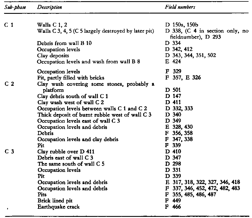
Phase C
Phase C shows walls built after the final destruction of the furnace walls. The stumps of walls B5 and B6 were still visible above the surface when a new wall, C1, was built on top of the remains of wall B2, running in the same direction. This is a comparatively heavy wall, of which very little survived in the excavated area. Wall C2 runs right across the ruined furnace.
The only other walls in this phase are walls C3 and C4. In none of these cases has sufficient evidence been uncovered to interpret these walls. The end of phase B is marked by a great fire on the surface which burnt over a large area and scorched the surface to a depth of 5-10 cms. in places. In phase C this is followed again by long stretches of occupation levels alternating with deposits of partly burnt clay and interrupted by pits. A curious oblong pit was discovered in sq.F. (F 449) It belongs to the end of the period. Its depth is c. 1.25 m. It was originally lined with bricks, and on the north side a brick pillar, still 7 courses high was found.
The end of phase C is marked by an earthquake. Here we find one of the very few cracks that can be dated to a phase. A deep, wide crack was discovered in sq. F 400. In it were found the scattered remains of a human skeleton. These are the only human bones found in the I.A. [Iron Age] occupation.
Phase C deposits have been divided into three sub-phases.
- Fig. 1 - Plan, mainly Phase IX (M)
from Ibrahim and van der Kooij (1986)
 Fig. 1
Plan, mainly Phase IX (M)
Ibrahim and van der Kooij (1986) - Fig. 2 - Section through Phases I-IX
from Ibrahim and van der Kooij (1986)
 Fig. 2
Section through Phases I-IX
Ibrahim and van der Kooij (1986)
Phase IX
The excavation of phase IX ( = Iron Age phase M of the definitive Deir 'Alla publications ) started in the 1960s, especially in 1967. That season an area of about 400 m2 of this phase was uncovered to the SE of the step trench excavated by Franken on the N slope of the tell some years earlier (cf. the elevation map of the site in ADAJ XXII, 1977-78, p. 58) . A small part of these excavations (square EE300) has been published in J. Hoftijzer and G. van der Kooij, Aramaic Texts from Deir 'Alla, Leiden 1976, in connection with the plaster inscriptions. Some further digging in EE300 (now labelled B/C5) was done in 1976, supplying a clearer picture of the immediate stratigraphic context of this plaster ( see ADAJ XXII pp. 60-71). In the programme for extending the excavations of this phase further to the SE (at the E top of the tell), small parts were excavated in 1979 (ADAJ XXIII pp. 48-50) and 1982 (ADAJ XXVII pp. 583f). In 1984 the excavations of phase IX took place on a larger scale, adding another 450 m2 to the area excavated. More than 20 `rooms' were discovered and added to those found in 1967 (see plan Fig. 1; Pl. XII shows a vertical photograph of a large part of the area, made near the end of the season by the Yarmouk University photographer Henry Cowherd with his camera attached to the top of a high pole). Some rooms, especially in the E part of the area, have not yet been excavated down to their floors. Less of the accumulated deposits of IX were left than had been expected. Digging activities during later periods (e. g. phase V/VI) had removed some of the IX deposits and levelling for phase VIII, and probably phase VI had also destroyed remains of IX which was built in a slightly terraced way (see the levels of floors indicated in plan Fig. 1). Sometimes nothing or only a few decimeters were left of the walls and debris, but often about half a meter and in the NW part walls more than one meter high were found.
Some aspects of the remains are briefly discussed below.
- from Franken (1976:7-16)
Only one relevant radiocarbon date of Phase M exists. The sample consisted of charred grain
from deposit BB 303, which was part of the burnt layer of Phase M. The date is 2600 ± 50 years
Before Present (Present = 1950). The "conventional" half-life of C14, i.e. 5568 years,
was used for this date. By applying a correction based on dendrochronology, the "true age" of
this sample "can be estimated at ca 800 B.C.". See the official
publication: J. C. VOGEL and H. T. WATERBOLK, Groningen Radiocarbon Dates X, Radiocarbon 14, 1972,
pp. 6-110; this sample GrN-5633 discussed on p. 53.
To understand this date some explanatory notes arc necessary (literature: generally J. W. MICHELS,
Dating Methods in Archaeology, New York and London. 1973, pp. 148.167; for the problems involved
see especially J.O.D. JOHNSTON, The problems of radiocarbon dating. Palestine Exploration Quarterly, 105,
1973, pp. 13-26).
- 650 B.C. ± 50 means, statistically, that there is a chance of 66% that the "true age" of the sample falls somewhere between 700 and 600 B.C. If this standard deviation is doubled. the chance would be 93% that the "true age" falls somewhere between 750 and 550 B.C. More C14 dates would give a clearer indication.
-
Radiocarbon chronology differs from historical chronology:
- The half-life of C14 is not yet precisely known. Nowadays preference is given to 5730 ± 40 years over the conventional 5568 ± 30 years. Consequently the C14 date based on the old value has to be multiplied by a factor of 1.03 to get the date based on the new value (i.e. ca 2678 years B.P. — ca 728 B.C.)
- Other uncertainties and difficulties concerning C14 exist.
This date has its own independent value compared with possible chronological conclusions drawn from archaeological, palaeographical and philological evidence.

- Fig. 1 - Top plan of the
recovered architectural remains of the last stage of Phase IX (Area B) from Ibrahim and van der Kooij (1991)
Fig. 1
Top plan of the recovered architectural remains of the last stage of Phase IX (Area B). Dotted lines refer to later disturbances (pits, erosion, egalisation)
Ibrahim and van der Kooij (1991)
The excavations at Deir “Alla were resumed in 1976 by a joint expedition of the Department of Antiquities in Amman, Leiden University, as well as Yarmouk University in Irbid, since 1980. Main preliminary reports have been published in ADA/ (FRANKEN, Torani, 1978, Isnaini, VAN DER Kooyj, 1979, 1983, 1986). The stratum called Phase M has been labelled Phase IX in these reports. The continuation of the excavations of Phase IX occurred in a minor way in 1976 (B/C5, the plaster text area), 1979 (B/C6) and 1982 (B/C8), but the main work was in 1984 and 1987.
... The study of most of the material remains is still in its initial stages, This means that the subjects referred to can only be dealt with provisionally here.
1. The Character of the Settlement
It is possible to study the character of the settlement rather well Although only a small part of the remains has been uncovered (c 800 m2, probably about 1/3 of what is left of the settlement) the quality of the remains is relatively good, for two reasons:
- The settlement had been destroyed suddenly, accompanied by fire at many places. This was apparently caused by an earthquake, as was concluded in 1967 from long cracks found immediately below the debris (Franken, 1976, pp. 7f.)
- The debris, had been relatively little affected by erosion and pit digging of later inhabitants except for the part in the E. squares, There erosion and egalisation for Phase VI has almost completely removed the remains of Phase IX.
The Stratigraphy
The total process of building up, use, modification and destruction of the phase is rather complicated. At many places the walls have been rebuilt and in several rooms walls have been added and removed, doorways closed and roofs fallen in. Also the final destruction went in stages. At first the roofs came down and parts of walls, Then the other parts of walls collapsed by a second earthshock, probably, and by man levelling the ruins. This second stage occurred after some time, because the new surface had been used a bit. The first destruction apparently was sudden enough for the inhabitants to leave probably all their chattels behind, but remains of victims caught by the collapse have not been found.
The Architecture
The excavated architectural complex shows a series of small rooms (Fig. 1). Most of them had been roofed, some by a reed mat only, but a few courtyards (some having one or more bread ovens) were open or only partially covered. The yard floors were often originally cobbled, but mud had washed over them and this was covered with reed layers, apparently during the rainy seasons. All the walls were made of mud-brick (size 46 x 32 x 11 cm). No stone foundation was used, but only reed layers to build the walls on. Most of the walls were as wide as one brick’s length, some of one brick’s width, and a few both length and width wide. It is difficult to combine rooms into larger units, because very often doorways are not clear: many of the walls do not have indications of expected door openings. Apparently the thresholds were high and constructed of mud bricks. In one case (the room in square B/B4, mainly used for storage) all the walls had been preserved 1 m high, but there were no doorways. Clearly the room had to be entered via the mud brick steps found at both sides of the W wall.
... 3. Dating Phase IX
Dating the remains of Deir 'Alla Phase IX is preliminarily being accomplished by two methods:
-
Cultural Stratigraphy and Comparison -
Comparative studies of cultural assemblages from different sites can not yet offer a very precise date,
for two reasons. Well established only in one, but rather in two or more successive strata/phases of a
site (supposing a correct archaeological stratigraphy is established) so for a precise comparison
frequency studies have to be included and relevant factors, such as the possibilities of cultural
contact, have to be evaluated. This information for other sites is hardly available. The second reason
is the margin for absolute dates of different strata. For many Iron Age strata absolute dates have
been proposed, often based on textual information only, but often alternative dates are possible.
This means for our subject, that the cultural relations of Deir 'Alla IX with other sites in the region and further afield, as discussed briefly above, indicate the 9th and 8th century BC. In any case before any Assyrian cultural influence is visible. This influence, however, may have started decades before the actual military-political incorporation of the region into the Assyrian empire (from c. 730 BC), but at some places it may also have become visible only decades after the Assyrian conquest.
On the other hand a terminus ante quem is given by the cultural identity of Deir 'Alla Phase VI, which has a close connection with Ammonite sites referred to above, to be dated in the 7th century or perhaps the end of the 8th century BC. -
14C Analysis -
Some Carbon-14 analyses have been done with carbonized plant remains (grain and leaves) from the
final destruction of Phase IX.
All three point to a time between 770 and 880 BC, with a high probability of the date being at the end of the 9th century BC. (see Mook, 1989).
A carbon-14 analysis of a sample from an earlier collapse of Phase IX gives a century older result; one from the preceding phase, two centuries older. Two carbon-14 dates from Phase VI point to the second half of the 8th century BC.8
Conclusion
A date for the destruction of Phase IX has to be looked for in the 9th and 8th centuries BC, but the statistic probability lies around 800 BC, and the last quarter of the 8th century is not really possible. Comparative cultural stratigraphy cannot yet add much to this. The date of c.760 BC for the destruction, suggested by an identification (LEMAIRE, 1985, p. 272) of the destructive earthquake with the one mentioned in the Old Testament for that time (e.g. Amos 1:1) is quite possible, but another earthquake may as well have been responsible for the destruction in this earthquake-rich region.
- Fig. 1 - Site Plan
from Ibrahim and van der Kooij (1997)
 Fig. 1
Site plan showing the squares excavated in 1987 and 1994, as well as the army trenches made in 1991.
Ibrahim and van der Kooij (1997) - Fig. 7 - from
Ibrahim and van der Kooij (1997)
 Fig. 7
Phase IX; B/C7.50 with pottery including:
- Phoenician jug with herbs
- Platter (originally with barley gruel)
- to the right: crushed jar with stored wheat
(Photo: Hubert de Haas)
Ibrahim and van der Kooij (1997)
Phase IX
The 1987 season (partly continued in 1994) was aimed at extending the knowledge of the plan and use of space of this phase. The relationship with the remains excavated in 1967 had to be made clear further to the north and west and in general the excavated area of the phase had to be enlarged so as to get a better picture of the character of the settlement, also in relation to the Balaam inscription and its role in a room in square B/C6. Furthermore some details of the sub-phasing of IX had to be studied, as well as its relation to the preceding phases, especially in the eastern squares.
.... The following results of these excavations concerning phase IX have to be mentioned in this report. See also the information presented in Picking up the threads..., especially pp.82-89 and 94-103; see also the authors (1991). See also the discussion in Wenning and Zenger 1991.
- Phase IX has a complicated building history, but it is not yet clear whether originally the set of adjoining rooms was planned and built as a whole. Several of the walls followed walls of a preceding phase. During the use of the complex of rooms at many places rebuilding, for example after roof collapse, and change of use of a room took place. After the destruction by earthquake and fire some levelling of the ruins took place, especially before, or for, phases VII and VI: the remains of phase IX were completely removed by these later human activities and by erosion in the eastern squares. Consequently the walls and rooms found in these squares B/A-C10 (see ADAJ 30 esp. 132, 136) belonged to a phase preceding phase IX (see below).
- The extension to the north till now revealed remains of phase IX in squares B/D-F7-9.
- The extension to the west revealed remains of phase IX in all three squares (B/A4 and B/B4+3, mainly in 1987: Fig. 7, with additions in 1994) that match with the architectural remains of "phase M" excavated in 1967 (see Vilders 1992). However, later pit digging had removed the remains at the western end.
- Some of the remains and objects have to be mentioned here. Cultivated plant remains show a large variety of crops. Apart from wheat and barley, flax had been very important, as well as a number of legumes. Also sesame was attested and several culinary herbs, some of them very rare, like black cummin, garden cress and basil (for details see Neef 1989). Weaving was represented by several groups of loomweights and tiny remains of cloth, with the threads made of hemp fibres (see Vogelsang-Eastwood, 1989). The pottery includes a number of "Phoenician" red slipped and burnished types, especially jugs with a double loop handle, trefoil-mouthed (Fig. 7; see also the authors 1991: 25) and an askos. Remarkable objects found in 1994 included a storage jar filled with plant-rich lime, apparently to be used for plaster work, as well as a bulla, going originally around a papyrus scroll.
- Fig. 5 - from
Ibrahim and van der Kooij (1979)
 Fig. 5
Ibrahim and van der Kooij (1979)
This phase IX is the same as phase M in previous countings. Much of it had been excavated in 1967 in an area of c. 25 x 25 m NW of the trenches dug during the last three seasons. Much of the architecture had been revealed, and some of it has been published preliminarily in J. Hoftijzer, G. van der Kooij, Aramaic Texts from Deir Alla, Leiden, 1976, (Pls. 16-19) and in A.D.A.J. op. cit. 1978, p. 64, fig. 6 (square B/C5). During this season excavations of phase M were done in one square only, namely in B/C6, to the E of B/C5, labeled EE 400 and EE 300 respectively in 1967. In 1967 it became clear that all the phase M architecture excavated had been destroyed by earthshock and fire. The room found in B/C6 was destroyed by fire too.
The walls are partly still standing up to 1.25 m high, and the room is found filled with burnt roof and wall debris. For a plan of the walls combined with those of B/C5 see plan drawing (fig. 5). The height of the debris (deposits 61 and 63) is shown on (Pl. XX, 2) where the floor is visible as well as the E most part of the burnt debris. Note also the lower course of mudbricks 57 going N-S at the top of the photograph. To the left is a doorway with a quern at the threshold. See also (Pl. XXI, 1) for a photograph of one stage in the removal of the debris inside the room. In the NW corner the floor of the room is visible. An especially interesting feature is the antler found as fallen almost directly on the floor of the room (Pl. XXI, 2). Some of the artifacts found may be mentioned here. Plates (XXVIII, 2- XXIX, 2) show some of the pottery found. A sealed jar handle (see Pl. XXX, 1). A shard with graffiti writing and drawing (PL XXX, 2). Phase IX probably has to be dated in the 8th century B.C. (PL XXXI).
- Fig. 1 -
Plan of Excavation Trenches of the 1977-1978 seasons from Franken and Ibrahim (1978)
Fig. 1
Tell Deir 'Alla Excavation Trenches
Franken and Ibrahim (1978) - Fig. 2 -
Square A/C1,S section with earthquake cracks from Franken and Ibrahim (1978)
 Fig. 2
Square A/C1,S section
JW: note presence of "earthquake cracks" looking like what one would find in a paleoseismic trench
Franken and Ibrahim (1978) - Fig. 3 -
Square A/C4,S section from Franken and Ibrahim (1978)
 Fig. 3
Square A/C4,S section
Franken and Ibrahim (1978) - Fig. 4 -
Square B/C5, plan phase "L" from Franken and Ibrahim (1978)
 Fig. 4
Square B/C5, plan phase "L" (broken truction). line: traces left; dotted line: reconstruction
Franken and Ibrahim (1978) - Fig. 5 -
Square B/C5, plan phase M from Franken and Ibrahim (1978)
 Fig. 5
Square B/C5, plan phase M (broken line: traces left; dotted line: reconstruction).
Franken and Ibrahim (1978) - Fig. 6 -
Squares B/C and D5, main part of E section from Franken and Ibrahim (1978)
 Fig. 6
Squares B/C and D5, main part of E section
Franken and Ibrahim (1978) - Fig. 7 -
Square B/C5: reconstruction of the position of the plaster texts from Franken and Ibrahim (1978)
 Fig. 7
Square B/C5: reconstruction of the position of the plaster texts.
Franken and Ibrahim (1978)
- Fig. 1 - Plan, mainly Phase IX (M)
from Ibrahim and van der Kooij (1986)
Fig. 1
Plan, mainly Phase IX (M)
Ibrahim and van der Kooij (1986)
Phase IX
Phase IX is identical with the heavily burnt phase M., much of which was excavated in 1967 (cf. also ADAJ, XXIII, p. 48f.). Further excavations and study of this phase is a major aim of the Deir research project. This season only a little digging was done in IX — just to see the character of its continuation to the S. (B/B6) and E. (B/C7-8) of the previously cleared parts of it. Next season excavation of a great deal of this phase is planned to be accomplished.
In B/B6 phase IX was just touched: a small part of the debris in presumably a room was excavated. Surprisingly no fire had occurred there, but the collapse apparently was as sudden there as in the fire destroyed rooms. (It may be useful to remember that an earthquake was the first cause of destruction to the buildings of this phase. Cf. p. 48.)
Two complete jars were laying together with a complete, about 0.65 m. long, antler of the Mesopotamian Fallow Deer (see Pls. CXXX,1; CXXX, 2). Interestingly the same type of antler was found, burnt, in a bordering room last season (Pl. XXI, 2). In square B/C7 the top of phase IX was uncovered in the N.E. part. The top of a N.-S. wall and of the burnt rubble inside a room became visible (see Pl. CXXIX, 1), which is part of the room excavated in B/C8. The E. wall of this room (B/C8.72) became visible up to square B/8 where part of the top of a cross wall was uncovered. A thin E.-W. wall forms the S. end of the room. The N. side is N. of square B/C8 and unexcavated. The mudbricks of the walls have the size common to the IX walls of the previous excavations (ca. 0.33 x 0.50 m.), many of them made of the yellow clay, others of grey soil. The walls still stand 1.00-1.50 m. high and, like elsewhere, had little width (one brick wide lying side by side, or even head to head). Mixed with the burnt roof and wall debris (see Pls. CXXXI, 12; CXXXII, 1;); with to the right two of the complete bricks, with marks on the surface) were the contents of the room: several jars and more than thirty loom-weights. The position of the loomweights suggests that they were in use in the room. Unexpectedly seven different types of weights were used together (see Pl. CXXXII, 2). It is noteworthy that one loomweight had clear remnants of thread (twisted vegetable fibres) inside the hole, others had different seeds. More interesting information may be added: an example of the commonly known pointed and polished flat bone tool (see Pl. CXXXIII, 1; two more examples were found this season) was found inside one of the pots lying among the debris and loomweights. This is another indication of the often suggested function of weaving.
- from Franken (1969:31-32) and Franken (1969:61-62)
- Fig. 3 -
from Franken (1969)

Fig. 3
Example of section drawing with description of the deposits.
Wall 1, phase F wall 8. Wall 2, phase C wall 5. Wall 3, phase B wall 10. D 267: Clay wash from wall 1. D 268: Gritty deposit (from building period of wall 1). D 269; D 276: pink coloured layers of organic material and fine clay deposits. D 279: clay wash. D 281: burnt surface, down to a depth of c. 10 cms. Organic material and ash, overlaid by thin levels of organic material. D 282, 329, 330: pink coloured organic material and clay. D 289: clay rubble from wall. D 292: clay wash from wall. D 299: partly red, burnt rubble from wall. D 331: gritty rubble from wall. D 332: rubble and wash from wall. D 333: Organic material and clay. D 334: Organic material and clay wash, overlaying a burnt surface. This surface runs under wall 2 and heat discoloured the earth to a depth of c. 5 cms. This burnt surface runs over levels of clay debris and wash from wall 3. Note the shift of slices of deposits, showing that usually the material sinks down on the north side. Cracks running through wall 1 did not cause a shift of material and have not been drawn. The crack just north of wall 1 caused a difference of height of the deposits of c. 25 cms., as can be seen on the burnt surfaces, drawn with a thick black line.
Franken (1969)
The earthquake cracks
Something has already been said, in conjunction with the methods of excavating, about the earthquake cracks that run through the tell.
Four observations on these cracks have to be taken into consideration before an attempt to explain them can be made.
- The excavated area in which the cracks occur is sited alongside and in the middle of the northern slope of the mound.
- All the cracks run more or less parallel to the line of the northern slope, or, to be more exact, to what is supposedly its original direction: i.e. slightly more to the northwest. There are no cracks running north-south.
- The frequency of these cracks becomes denser and the cracks deeper the farther they lie to the north.
- The slices of earth between the cracks all tend to topple forward to the north and some of them have sunk down considerably (cf. fig. 3) or even slightly turned round a horizontal north-south axis.
It is not yet known how these cracks run on the east and west sides of the tell. If these cracks are really caused by earthquakes then they will continue down into the natural soil under the tell itself. It has not yet been possible to establish this point one way or the other. There are, however, many cracks running through the banded clay outside the tell area. It seems best to consider a combination of two factors as the cause of these cracks. There is the weight of the deposits with no strong walls, no glacis or revetment wall to check the settling and shifting of the material; and there is the geological fact that the Jordan valley lies in a well-known seismic area; so that earth tremors strong enough to dislodge the material of which the tell is composed would have been present on and off through the ages.
In two cases, however, this type of crack can be assigned to a phase in the Iron Age. Cf. Plate IV, phase C.
Phase M
The pottery from phase M has not been used in the following pottery study. It is possible that there was a period after phase L in which the tell was hardly occupied. There are various indications for this supposition. There is an accumulation of washed material over the phase L buildings. Phase M shows a new lay-out of the village, but this could also be the case if a large part of phase L were destroyed on any one occasion. More important is, however, the fact that the large "cistern" which is attributed to phase M, contains some pottery shapes, which do not belong to the village repertoire, nor to that of period III. There must have been a much shorter gap in time between phases L and M (plus N) than there is between phases M-N and the new occupation of period III. The bulk of the phase M pottery comes from the "cistern", as the period III pits and the cemetery have largely destroyed the surface of phase M, and the plan of phase N has been entirely reconstructed from wall fragments found between pits and graves. The publication of the pottery from these phases will follow after the excavation has been extended.
The only wall of phase L which still stood in phase M is wall M 1, not used as a house wall, but as part of a catchment area for water, a plaster floor to the n. of it running up against this wall. This is the only plastered floor found in the E.I.A. deposits. On the same absolute level further n. another plastered floor was found, which is a terrassed floor belonging to period III. This floor shows that a considerable amount of erosion took place between periods II and III.
The most striking and peculiar feature of phase M is the large "cistern", to which the plastered floor led the rainwater. This floor actually formed the rim of the pit along the s.e. side, sloping down into the pit. The diameter of this pit is slightly over 8 m. and its depth has not yet been established. It had destroyed underlying deposits at least down to phase G. The purpose of this pit or "cistern" is not clear. Nowhere were there any indications that it was plastered below the rim. It is also certain that no staircase went down into it. Had that been the case it could be supposed that it was dug in a desperate attempt of the villagers to reach ground water level during a siege. If it was meant to collect rainwater, as the "catchment floor" would suggest, it was equally a failure, even had there been a plaster lining. (Pl. XIb)
From the stratigraphy it is clear that the pit had a very short existence and in fact already served as a refuse pit during phase M. All the pottery fragments found in the pit are covered with iron oxide incrustation, suggesting that broken pots were thrown into thick layers of vegetable material that gradually filled the pit. In the next phase (N) a thick clay deposit was put down over the top on which a house was built (P1. XII). This clay "lid" subsequently sank more than a metre into the soft fill, breaking off around the edge of the pit. The problem of interpretation remains and is not elucidated by the fact that it was not the first pit of its kind, cf. phase J. The phase J pit must have been less wide, and the phase M pit took up more space. From the fact that the pit was already used as a refuse pit during phase M we can conclude that, whatever its original purpose, it soon lost this function.
All the walls of the phase were very fragmentarily preserved in this area. (see above). Walls M 2,3 formed a room. N. of wall M 3 was an open space, blocked by wall M 4. This courtyard shows an earthquake crack which dates from phase M or N. N. of wall M 3 and s. of wall M 5 (Pl. XIa) were found two stone benches, built against these walls, facing each other. Two n.-s. walls were built n. of wall M 5 and the floor space between them was covered by a stone platform.
As all possible links between walls M 6,7,8,9 were destroyed by the graves, no interpretation can be given until excavation further e. has revealed more of the plan of this phase.
Note. After this manuscript was finished the contents of the cistern were studied. Comparison with the phase M material, which definitely belongs to the village, and with material from phase N, has clearly shown that the cistern cannot belong to either of these phases, but to an intermediate period. We have to assume that whether phase M was followed by one or more phases of village occupation, erosion followed after the village was definitely abandoned. Then people dug a pit and made a "catchment floor" running up against the stump of a wall which they found standing, and after that the tell was again abandoned, now for a considerable length of time. This interpretation is based on the study of the pottery only. It is difficult to see why in the second period of erosion the rim of the pit did not erode away completely, unless, as we have reason to believe, buildings belonging to the village (period II) were standing on a much higher level east of the excavated area. In this case the lower parts which were more or less horizontal would be covered by eroded material before erosion started to denude these lower levels. The pottery of the cistern will be published after the excavation of phase N and subsequent phases has been finished.
- Figure 3 -
Time-stratigraphic correlation chart of Iron IIb excavations throughout an extensive region of Israel and Jordan from Austin et. al. (2000)
 FIG. 3
Time-stratigraphic correlation chart of Iron IIb excavations throughout an extensive region of Israel and Jordan. Datum for correlation is earthquake debris or rebuilding horizons assigned to a single, 750 B.C. seismic event. Locations of cities are shown in Figure 1. Strata names at each site are from primary archaeological reports.
Symbols
- P = pottery date
- C-14 = radiocarbon date
- T = dated text material
- D = military destruction layer with historical date assigned
- A = historically dated architectural style
- E = earthquake destruction layer
- E ? = probable earthquake destruction layer (significant rebuilding horizon without evidence of military conquest)
Austin et. al. (2000)
Deir Alla was an Iron Age city located near the confluence of the Jabbok River with the Jordan River (Fig. 1). Architecture was primarily mud bricks on a foundation of Quaternary alluvium. Therefore, the constructions were very susceptible to earthquake damage. Cracked foundations and fallen walls characterize phase IX (also called phase M) at Deir Alla (Ibrahim and van der Kooij, 1977, 1978, 1979). Walls constructed of mud bricks tended to fall in a southerly direction (Lemaire, 1985). The suddenness of the collapse is most vividly indicated by the extraordinary preservation of an ink-on-plaster inscription that was excavated from beneath the debris of one fallen wall. This famous inscription is called the Balaam Text and, ironically, foretells a cosmic disaster (Lemaire, 1985).
Deir Alla phase IX (= phase M) is dated by radiocarbon and ceramic evidence (Fig. 3). Carbon date GrN-14260 on grain and leaf material beneath earthquake rubble gave 2630 ± 50 years B.P. (van der Kooij, 1993), which calibrates to 800 ± 50 B.C. (Stuiver and Becker, 1993). The Balaam Text shows signs of wear, indicating that it stood for many years before being buried by an earthquake. One paleographer dates the inscription to the middle of the eighth century, or even a decade or two earlier than that (Naveh, 1967). The pottery analysis suggests that phase IX ended ~770 B.C. (Ibrahim and van der Kooij, 1977, 1978, 1991; Vilders, 1992). This is consistent with an earthquake dated at 770 B.C. ± 25 years.
- Fig. 1 - Site Plan
from Ibrahim and van der Kooij (1997)
Fig. 1
Site plan showing the squares excavated in 1987 and 1994, as well as the army trenches made in 1991.
Ibrahim and van der Kooij (1997)
Phase VII
One of the surprises of the 1994 season was the quality and quantity of data retrieved from phase VII. Some scattered remains of it (wall fragments, courtyard layers and pits) became known in 1984, including a fallen wall with many of the bricks still in original binding, but in a vertical position—identified as such in 1987. In the same year, remains were found in the western extension too (B/B4-3). However, the architectural remains were concentrated in square B/A6 and surroundings. In 1994 other concentrations of remains were found in squares D/A+B7, squares B/D+E9, and square B/F7.
The remains show a sudden collapse of buildings, with fire at places, all caused by an earthquake as probably shown by the crack and shift down in D/B7. After a process of erosion and levelling, the debris was preserved only up to a height of 10-20cm, often leaving just the lower parts of pots sitting on the floor. One of the walls (in square D/A7) had fallen down in the same way as mentioned before, with many of the bricks still bound together, but now in a vertical position.
The lay-out of the rooms is not clear (several of the walls are expected outside the squares) but the floors in square D/B7 (the "museum") and B/E9 (the "kitchen") were covered with all kinds of artifacts. They include (Fig. 4) bone-inlay, a stone object (3255) of uncertain use, an extraordinary dagger, a sheqel weight (3302), a cosmetic bowl of sandstone (3285), a potter's wheel as well as pottery (Fig. 5; thrown and well-fired) that represents types known from Neo-Assyrian palaces, apart from local types. These data show a rather strong change of cultural character after the phases IX and VIII. Possibly the seal no. 2307 (Fig. 6, inscribed lmlkwm) came from phase VII.
| Effect | Location | Image | Description |
|---|---|---|---|
|
Deir 'Alla
Fig. 1 Tell Deir 'Alla Excavation Trenches Franken and Ibrahim (1978) |
Plate VIb Phase A accumulation over the red burnt L.B. ruins. Thick ash deposit (D 908), interrupted by pits and cracks. Click on image to open in a new tab Franken (1969) |
|
| Effect | Location | Image | Description |
|---|---|---|---|
| Flower Structure | Trench D100
Fig. 1 Tell Deir 'Alla Excavation Trenches Franken and Ibrahim (1978)
Figure 6Excavating in Trench D, the 30-meter section trench, looking east from the Tell Deir ‘Alla archive). Halbertsma (2019) |
Fig. 21
Figure 21 Trench D100, looking south from D500. Visible is the heavily burnt surface of one of the installations (also visible in figure 18), and the various earthquake cracks complicating the stratigraphy in this part of the tell JW: Note the Flower Structure (from the Tell Deir ‘Alla archive). Halbertsma (2019) |
|
| Vertical Cracks | Trench D100
Fig. 1 Tell Deir 'Alla Excavation Trenches Franken and Ibrahim (1978)
Figure 6Excavating in Trench D, the 30-meter section trench, looking east from the Tell Deir ‘Alla archive). Halbertsma (2019) |
Plate Vb
Plate Vb Trench D, looking s. Foreground phase A courtyards. Burnt floor of B 1 furnance. Top left the round tower, (wall K 13), cut through wall F (G) 8. Below the round tower remains of wall E 7 and phase D courtyards. Franken (1969) |
|
| Fire | Trench D100
Fig. 1 Tell Deir 'Alla Excavation Trenches Franken and Ibrahim (1978)
Figure 6Excavating in Trench D, the 30-meter section trench, looking east from the Tell Deir ‘Alla archive). Halbertsma (2019) |
Fig. 21
Figure 21 Trench D100, looking south from D500. Visible is the heavily burnt surface of one of the installations (also visible in figure 18), and the various earthquake cracks complicating the stratigraphy in this part of the tell JW: Note the Flower Structure (from the Tell Deir ‘Alla archive). Halbertsma (2019) Fig. 18
Figure 18Entry to one of the installations, most likely D148, looking north. Note the black-burnt surface (from the Tell Deir ‘Alla archive). Halbertsma (2019) |
|
| Collapsed Walls |
|
| Effect | Location | Image | Description |
|---|---|---|---|
| Rubble | Field Number D410 |
|
|
| Crack |
|
Plate IVa Phase C Earthquake Crack
Plate IVa Photograph of section 5.50/15.50-20, with earthquake crack, dated to phase C Franken (1969) Plate IVb Phase C Earthquake Crack
Plate IVbSection Drawing of section 5.50/15.50-20, with earthquake crack, dated to phase C Franken (1969) |
|
| Effect | Location | Image(s) | Description |
|---|---|---|---|
| Broken Pottery found in fallen position | Area B
Fig. 1 Plan, mainly Phase IX (M) Ibrahim and van der Kooij (1986) |
|
|
| Collapsed and displaced walls, two seismic shocks, fractures, and fire | Area B ?
Fig. 1 Plan, mainly Phase IX (M) Ibrahim and van der Kooij (1986) |
|
| Effect | Location | Image(s) | Description |
|---|---|---|---|
| Fractures on pavement | Area B plus perhaps a significant part of the Tell
Fig. 1 Plan, mainly Phase IX (M) Ibrahim and van der Kooij (1986) |
Vertical cracks mostly in an E-W direction were observed at least every 20 cm in Area B and, it appears, in other parts of the Tell. Not all of these cracks were associated with the Phase M/IX earthquakes but may have been caused by several quakes that struck the site over the centuries. However some cracks in Area B terminated at the contact between Phase M/IX and an overlying "erosion" layer (their terminology) and this stratigraphic relationship dates these cracks to the Phase M/IX Earthquake(s); just like in a paleoseismic trench. Franken (1976) described a 10 cm. wide extensional crack which, by context, appears to be in Area B and associated with one of the Phase M/IX earthquakes. This extension crack suggests a high level of Intensity and that some normal stresses were associated with the causitive earthquake. | |
| Anthropic compacted substratum | "the excavated area" and perhaps a significant part of the Tell
Fig. 1 Plan, mainly Phase IX (M) Ibrahim and van der Kooij (1986) |
Franken (1969) and Franken (1976) noted that parts of the Tell had sunk but did not seem to associate this with one specific earthquake of the several that struck the site over the centuries. Or maybe he did. Franken's prose is, at times, confusing. | |
| Collapsed Walls | Area B
Fig. 1 Plan, mainly Phase IX (M) Ibrahim and van der Kooij (1986) |
Franken (1976)
noted that some mudbrick walls broke away at floor level. Although this suggests very high levels of Intensity, these structures lacked a foundation and the walls were only one mudbrick thick. These were weak structures. |
|
| Displaced Masonry Blocks | Area B
Fig. 1 Plan, mainly Phase IX (M) Ibrahim and van der Kooij (1986) |
Franken (1976)
noted that other mudbrick walls broke above floor level after the whole wall had shifted |
-
Earthquake Archeological Effects chart
of Rodríguez-Pascua et al (2013: 221-224)
 Earthquake Archeological Effects (EAE)
Rodríguez-Pascua et al (2013: 221-224)
| Effect | Location | Image | Description | Intensity | |
|---|---|---|---|---|---|
|
Deir 'Alla
Fig. 1 Tell Deir 'Alla Excavation Trenches Franken and Ibrahim (1978) |
Plate VIb Phase A accumulation over the red burnt L.B. ruins. Thick ash deposit (D 908), interrupted by pits and cracks. Click on image to open in a new tab Franken (1969) |
|
VII+ |
|
-
Earthquake Archeological Effects chart
of Rodríguez-Pascua et al (2013: 221-224)
Earthquake Archeological Effects (EAE)
Rodríguez-Pascua et al (2013: 221-224)
| Effect | Location | Image | Description | Intensity |
|---|---|---|---|---|
| Flower Structure | Trench D100
Fig. 1 Tell Deir 'Alla Excavation Trenches Franken and Ibrahim (1978)
Figure 6Excavating in Trench D, the 30-meter section trench, looking east from the Tell Deir ‘Alla archive). Halbertsma (2019) |
Fig. 21
Figure 21 Trench D100, looking south from D500. Visible is the heavily burnt surface of one of the installations (also visible in figure 18), and the various earthquake cracks complicating the stratigraphy in this part of the tell JW: Note the Flower Structure (from the Tell Deir ‘Alla archive). Halbertsma (2019) |
|
VII+ |
| Vertical Cracks | Trench D100
Fig. 1 Tell Deir 'Alla Excavation Trenches Franken and Ibrahim (1978)
Figure 6Excavating in Trench D, the 30-meter section trench, looking east from the Tell Deir ‘Alla archive). Halbertsma (2019) |
Plate Vb
Plate Vb Trench D, looking s. Foreground phase A courtyards. Burnt floor of B 1 furnance. Top left the round tower, (wall K 13), cut through wall F (G) 8. Below the round tower remains of wall E 7 and phase D courtyards. Franken (1969) |
|
VII+ |
| Collapsed Walls |
|
VIII+ |
-
Earthquake Archeological Effects chart
of Rodríguez-Pascua et al (2013: 221-224)
Earthquake Archeological Effects (EAE)
Rodríguez-Pascua et al (2013: 221-224)
| Effect | Location | Image | Description | Intensity |
|---|---|---|---|---|
| Collapsed Walls (?) inferred from Rubble | Field Number D410 |
|
VIII+? | |
| Crack |
|
Plate IVa Phase C Earthquake Crack
Plate IVa Photograph of section 5.50/15.50-20, with earthquake crack, dated to phase C Franken (1969) Plate IVb Phase C Earthquake Crack
Plate IVbSection Drawing of section 5.50/15.50-20, with earthquake crack, dated to phase C Franken (1969) |
|
VII+ |
-
Earthquake Archeological Effects chart
of Rodríguez-Pascua et al (2013: 221-224)
Earthquake Archeological Effects (EAE)
Rodríguez-Pascua et al (2013: 221-224)
| Effect | Location | Image(s) | Description | Intensity |
|---|---|---|---|---|
| Fractures on pavement | Area B plus perhaps a significant part of the Tell
Fig. 1 Plan, mainly Phase IX (M) Ibrahim and van der Kooij (1986) |
Vertical cracks mostly in an E-W direction were observed at least every 20 cm in Area B and, it appears, in other parts of the Tell. Not all of these cracks were associated with the Phase M/IX earthquakes but may have been caused by several quakes that struck the site over the centuries. However some cracks in Area B terminated at the contact between Phase M/IX and an overlying "erosion" layer (their terminology) and this stratigraphic relationship dates these cracks to the Phase M/IX Earthquake(s); just like in a paleoseismic trench. Franken (1976) described a 10 cm. wide extensional crack which, by context, appears to be in Area B and associated with one of the Phase M/IX earthquakes. This extension crack suggests a high level of Intensity and that some normal stresses were associated with the causitive earthquake. | VI+ according the EAE chart but the cracks terminated by stratigraphy suggest at least VII using rules of thumb from Paleoseismology. | |
| Anthropic compacted substratum | "the excavated area" and perhaps a significant part of the Tell
Fig. 1 Plan, mainly Phase IX (M) Ibrahim and van der Kooij (1986) |
Franken (1969) and Franken (1976) noted that parts of the Tell had sunk but did not seem to associate this with one specific earthquake of the several that struck the site over the centuries. Or maybe he did. Franken's prose is, at times, confusing. | VI-VII+ | |
| Collapsed Walls | Area B
Fig. 1 Plan, mainly Phase IX (M) Ibrahim and van der Kooij (1986) |
Franken (1976)
noted that some mudbrick walls broke away at floor level. Although this suggests very high levels of Intensity, these structures lacked a foundation and the walls were only one mudbrick thick. These were weak structures. |
VIII+ | |
| Displaced Masonry Blocks | Area B
Fig. 1 Plan, mainly Phase IX (M) Ibrahim and van der Kooij (1986) |
Franken (1976)
noted that other mudbrick walls broke above floor level after the whole wall had shifted |
VIII+ | |
| Broken Pottery found in fallen position | Area B
Fig. 1 Plan, mainly Phase IX (M) Ibrahim and van der Kooij (1986) |
|
VII+ |
-
Earthquake Archeological Effects chart
of Rodríguez-Pascua et al (2013: 221-224)
Earthquake Archeological Effects (EAE)
Rodríguez-Pascua et al (2013: 221-224)
| Effect | Location | Image | Description | Intensity |
|---|---|---|---|---|
| Collapsed Walls | square D/B7 (the "museum") and ? |
|
VIII+ | |
| Displaced Masonry Blocks | square D/B7 (the "museum") and "places" |
|
VIII+ |