Damiya
 Tall Damiya in Google Earth
click on image to explore this site on a new tab in Google Earth
| Transliterated Name | Source | Name |
|---|---|---|
| Damiya | Arabic | |
| Damieh | Arabic | |
| Damiyeh | Arabic | |
| Tall Damiyah | Arabic | |
| Adam Ha-ir | Hebrew |
- Fig. 1 - Location Map
from Petit & Kafafi (2016)
 Fig. 1
Location Map
Petit & Kafafi (2016) - Location Map from
Van der Kooij (2006)
 Fig. 1
Map of Deir 'Alla region, based upon topographic map 1947
Van der Kooij (2006) - Jordan Valley Sites from
Ferry et al. (2011)
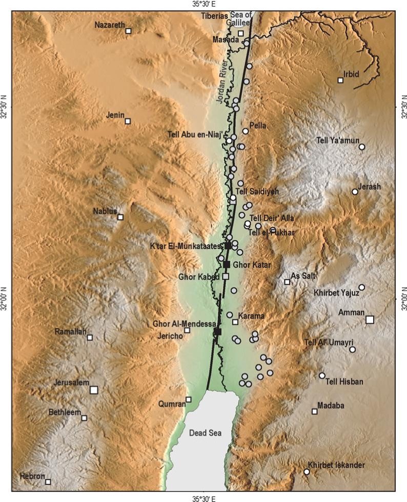 Figure 6
Archaeology of the Jordan Valley.
- White squares, main populated areas cited in historical documents
- white dots, archaeological sites visited and reappraised in this study
- gray dots are archaeological sites not studied here (lack of evidence and/or available literature) but of potential interest for future studies
- gray squares, paleoseismic sites
- black squares, geomorphological sites studied by Ferry et al. (2007)
Ferry et al. (2011)) - Fig. 2 Map of Iron Age I
sites in the Jordan Valley from Halbertsma (2019)
 Figure 2
Map of the Jordan Valley with Iron Age I sites mentioned in the thesis. The open circles are modern cities.
Halbertsma (2019) - Fig. 13 Map of Iron Age sites
in the Jordan Valley from Halbertsma (2019)
 Figure 13
Map of Iron Age sites discussed in this chapter
(after Van der Steen 1999, 179).
Halbertsma (2019) - Fig. 4.1 Map of sites
in central and northern Israel and Jordan from Mazar et. al. (2020 v.1)
 Fig. 4.1
Map of major archaeological and historical site in central and northern Israel and Jordan
Mazar et. al. (2020 v.1)
- Location Map from
Van der Kooij (2006)
Fig. 1
Map of Deir 'Alla region, based upon topographic map 1947
Van der Kooij (2006) - Jordan Valley Sites from
Ferry et al. (2011)
Figure 6
Archaeology of the Jordan Valley.
- White squares, main populated areas cited in historical documents
- white dots, archaeological sites visited and reappraised in this study
- gray dots are archaeological sites not studied here (lack of evidence and/or available literature) but of potential interest for future studies
- gray squares, paleoseismic sites
- black squares, geomorphological sites studied by Ferry et al. (2007)
Ferry et al. (2011)) - Fig. 2 Map of Iron Age I
sites in the Jordan Valley from Halbertsma (2019)
Figure 2
Map of the Jordan Valley with Iron Age I sites mentioned in the thesis. The open circles are modern cities.
Halbertsma (2019) - Fig. 13 Map of Iron Age sites
in the Jordan Valley from Halbertsma (2019)
Figure 13
Map of Iron Age sites discussed in this chapter
(after Van der Steen 1999, 179).
Halbertsma (2019) - Fig. 4.1 Map of sites
in central and northern Israel and Jordan from Mazar et. al. (2020 v.1)
Fig. 4.1
Map of major archaeological and historical site in central and northern Israel and Jordan
Mazar et. al. (2020 v.1)
- Tall Damiya in Google Earth
Tall Damiya in Google Earth
click on image to explore this site on a new tab in Google Earth
- Fig. 4 Site Plan with
excavation squares from Kafafi & Petit (2018)
 Fig. 4
Site Plan with Location of Squares.
Kafafi & Petit (2018) - Fig. 2 Excavation Squares
of Areas A and B from Petit & Kafafi (2016)
 Figure 2
Contour map of Tell Damiyah with excavation areas
Drawing by Muwaffaq Bataineh
Petit & Kafafi (2016) - Fig. 4 Site Plan with
excavation squares from Petit et al. (2023)
 Figure 4
Site plan with location of squares in red (dark gray in this black and white image)
Drawing by Muwaffaq Bataineh
Petit et al. (2023)
- Fig. 4 Site Plan with
excavation squares from Kafafi & Petit (2018)
Fig. 4
Site Plan with Location of Squares.
Kafafi & Petit (2018) - Fig. 2 Excavation Squares
of Areas A and B from Petit & Kafafi (2016)
Figure 2
Contour map of Tell Damiyah with excavation areas
Drawing by Muwaffaq Bataineh
Petit & Kafafi (2016) - Fig. 4 Site Plan with
excavation squares from Petit et al. (2023)
Figure 4
Site plan with location of squares in red (dark gray in this black and white image)
Drawing by Muwaffaq Bataineh
Petit et al. (2023)
- Fig. 5 Iron Age IIc
occupation (Stratum VII) with excavation squares from Petit & Kafafi (2016)
 Figure 5
Top plan of the Iron Age IIc occupation (Stratum VII) at Tell Damiyah
Drawing by Lucas Petit
Petit & Kafafi (2016)
- Fig. 5 Iron Age IIc
occupation (Stratum VII) with excavation squares from Petit & Kafafi (2016)
Figure 5
Top plan of the Iron Age IIc occupation (Stratum VII) at Tell Damiyah
Drawing by Lucas Petit
Petit & Kafafi (2016)
- Fig. 4 Excavation squares
in Area A from Petit et al. (2023)
 Figure 4 Inset
Location of squares in red (dark gray in this black and white image)
Drawing by Muwaffaq Bataineh
Petit et al. (2023)
- Fig. 4 Excavation squares
in Area A from Petit et al. (2023)
Figure 4 Inset
Location of squares in red (dark gray in this black and white image)
Drawing by Muwaffaq Bataineh
Petit et al. (2023)
- Fig. 3 Photo of Tall Dāmiyah
from Kafafi & Petit (2018)
 Fig. 3
Tall Dāmiyah (MEGA number: 2750, DAAHL Site number: 353200251).
Kafafi & Petit (2018) - Fig. 4 Photo of Tall Dāmiyah
from Petit & Kafafi (2019)
 Fig. 4
Tell Damiyah in 2018
Petit & Kafafi (2019) - Fig. 8 Fallen Roof Roller
from Kafafi & Petit (2018)
 Fig. 8
White Plastered Wall and the Roof Roller from the 7th Century BC
Kafafi & Petit (2018) - Fig. 11 Fallen Roof Roller
from Petit (2013)
 Fig. 11
A stone roof roller from roof debris in square VIII.
Petit (2013) - Fig. 1 Broken Pottery in
a storeroom from Petit & Kafafi (2020)
 Fig. 1
One of the storage rooms in the east part of the late Iron Age complex
Petit & Kafafi (2020) - Fig. 2 Fragments of a
painted pithos (large storage container) on the floor from Petit & Kafafi (2020)
 Fig. 2
Fragments of a painted pithos [large storage container] on the floor of a rectangular freestanding building.
JW: This is the same photo as shown in Fig. 7 of Petit & Kafafi (2019)
Petit & Kafafi (2020) - Fig. 31 Crushed Pottery
bowl from Petit & Kafafi (2018)
 Fig. 31
A crushed pottery bowl found next to the remains of a mudbrick building. In the left corner are the remains of a tabun
(photo courtesy of Lucas Petit)
Petit & Kafafi (2018) - Fig. 9 Broken pottery
from Petit et al. (2023)
 Figure 9
Restorable pottery in square XIX
photo Yousef al Zu'bi
Petit et al. (2023) - Fig. 6 Excavation work
in 2019 (broken pottery in foreground) from Petit et al. (2023)
 Figure 6
Excavation work in 2019
photo Yousef al Zu'bi
Petit et al. (2023) - Paleo-Landslide Scar near
Damiya in Jordan
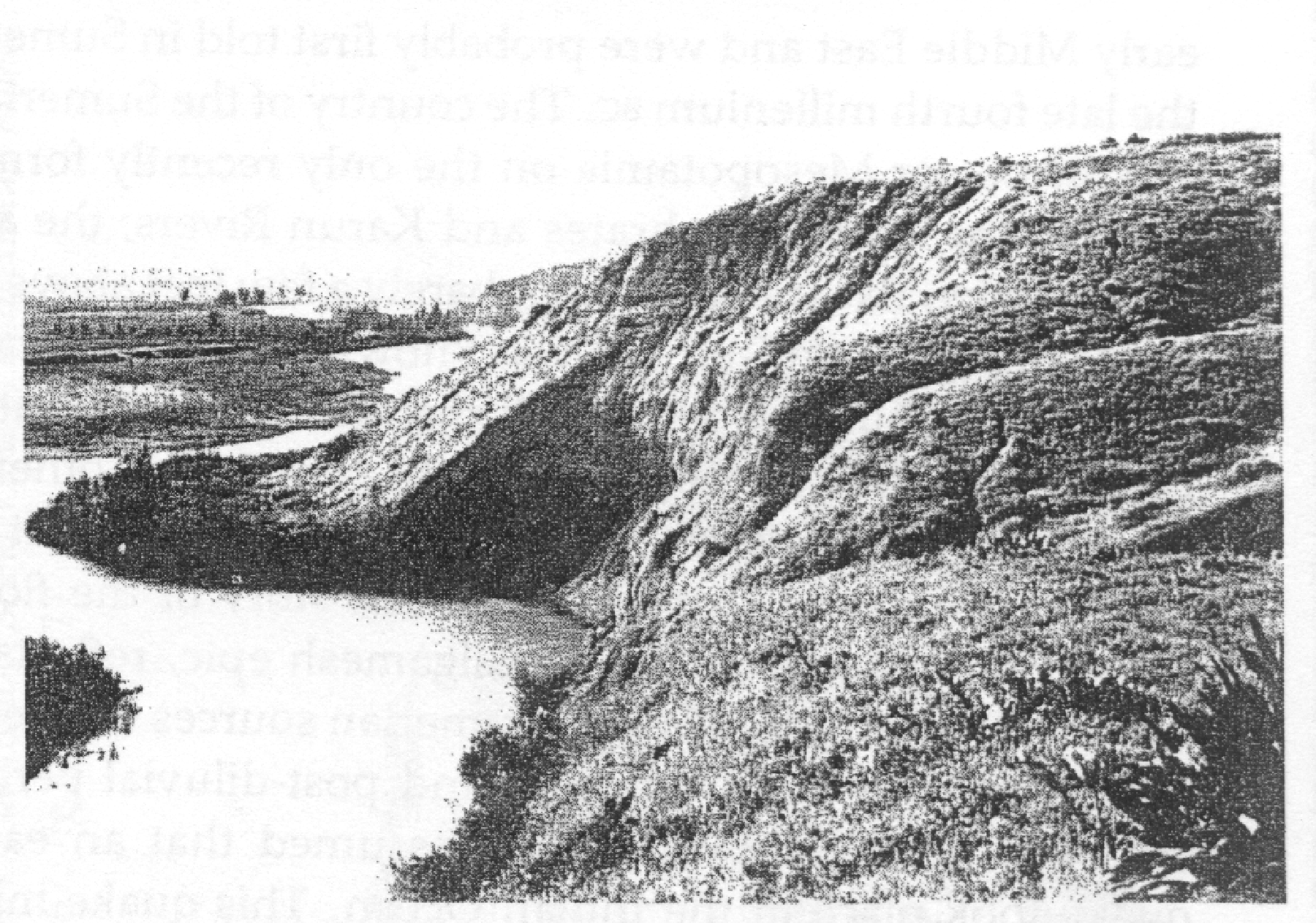 Photo taken in 1947 or 1948 of an old Landslide near the modern town of Damiya in Jordan
Unknown (forgotten) provenance
- Fig. 2 Sampling Photos
from al Khasawneh et al. (2020)
 Fig. 2
Samples from the two sections in
- square I
- square VII
al Khasawneh et al. (2020) - Fig. 4 OSL Ages plot
from al Khasawneh et al. (2020)
 Fig. 4
OSL ages from the two sections shown as related to their depths. error bars represent total error.
al Khasawneh et al. (2020) - Table 1 14C ages
from al Khasawneh et al. (2020)
 Table 1
Relevant radiocarbon ages for five samples 14C ages to the highest probability, calibrated to BCE using OxCal v4.3.2 Ramsey (2017); InterCal atmospheric curve (Reimer et al. 2013).
al Khasawneh et al. (2020) - Table 3 OSL ages
from al Khasawneh et al. (2020)
 Table 3
Equivalent doses, total dose rate and calculated OSl ages.
al Khasawneh et al. (2020)

- Fig. 5 Iron Age IIc
occupation (Stratum VII) with excavation squares from Petit & Kafafi (2016)
Figure 5
Top plan of the Iron Age IIc occupation (Stratum VII) at Tell Damiyah
Drawing by Lucas Petit
Petit & Kafafi (2016)
- Fig. 5 Iron Age IIc
occupation (Stratum VII) with excavation squares from Petit & Kafafi (2016)
Figure 5
Top plan of the Iron Age IIc occupation (Stratum VII) at Tell Damiyah
Drawing by Lucas Petit
Petit & Kafafi (2016)
- Fig. 5 Iron Age IIc
occupation (Stratum VII) with excavation squares from Petit & Kafafi (2016)
Figure 5
Top plan of the Iron Age IIc occupation (Stratum VII) at Tell Damiyah
Drawing by Lucas Petit
Petit & Kafafi (2016)
- Fig. 5 Iron Age IIc
occupation (Stratum VII) with excavation squares from Petit & Kafafi (2016)
Figure 5
Top plan of the Iron Age IIc occupation (Stratum VII) at Tell Damiyah
Drawing by Lucas Petit
Petit & Kafafi (2016)
Results (Stratigraphy and Finds)
Excavations
Excavation work was carried out in 6 squares, numbered I, III, IV, VII, VIII and XII (Fig. 4). The preliminary results provided here are based on all excavation seasons (hence including data from the 2004, 2005, 2012 and 2013 seasons), although the 2014 season provided substantially more information, and solved several stratigraphic problems. The results are presented chronologically, commencing with the oldest occupation phase excavated so far. The excavators recognized several archaeological strata, which are all included in this report.
The oldest occupation remains were encountered in Squares I and III. They consist of thick deposits of occupation layers, with some complete pottery objects, and others which are restorable. The layers contain mud brick fragments, similar to some structures on the summit. The pottery, such as a complete bowl and small black juglet, can be dated to Iron Age IIC, somewhere around 700 BC. The presence of large clay loom weights suggest some textile production on the site (Fig. 6). One special find was a bone seal which depicted a lion.
The next occupation level, also from Squares I and III, encompasses the remains of several mud brick walls, oriented NW-SE which are extant in numerous occupation layers. The pottery, all fragmentary, can be dated exclusively to the 7th century BC. A possible oven associated with this level was found in Square III. Either contemporaneous or immediately on top of this phase was a thick deposit of courtyard layers; in 2014, most of the excavation in this area took place in Square IV (Fig. 7). Successive greyish floors, some of which were plastered, were interrupted by a number of stones.
These stones range in size, from medium to small unhewn, and are all river stones, sourced from the basins of both the Zarqa and Jordan Rivers. Fireplaces and post holes were identified in these layers. Possible associated remains of a mud brick structure, destroyed by a heavy conflagration, were discovered in 2012 (Square VII) and 2014 (Square VIII). However, this level was only reached in two small spots, and the shape of this building cannot be determined. At least two ovens “tabuns” were in use during this phase in Square XII. The pottery is consistent and clearly Iron Age IIC, including a number of Assyrian Palace Ware and Ammonite sherds. The next occupation phase, still dated to the 7th century BC, can be associated with an Assyrian presence. The discovery in 2004 of a clay bulla with Akkadian writing, and numerous Assyrian Palace Ware-sherds (in this and previous seasons) indicates increasing contact with the Neo-Assyrian Empire. But there was definitely contact with the Cypro-Phoenician coast and Egypt also.
At least two rectangular buildings separated by a small alley are located on the southeastern summit of Tall Dāmiyah; unfortunately, very little of the southern building has been preserved due to the bulldozer cut. The other building is rectangular, with a doorway in the SE-corner. The interior of the walls were white lime-plastered (Fig. 8), and a type of platform was situated against the western wall, which was also covered with plaster. It was difficult to get a complete plan of this building due to several later pits and burials. The pottery is clearly Iron Age IIC, some of which could be restored (in 2012 and 2013). A large stone roof roller was found on top of debris in the most northern building. The most important and intriguing finds were, however, several figurines and anthropomorphic jars.
North of the platform, near the western wall, four animal figurines (cf. Fig. 9) and a possible anthropomorphic jar statue was found. Two similar statues were found in Square IV in 2005 and 2012 (e.g. Petit 2009). In that same area, which is situated southeast of the plastered building, several other animal and human figurines were discovered. The courtyard layers may be contemporaneous with these finds. If this is the case, it can be assumed that the white plastered building had a cultic function. Further analyses on the objects and the stratigraphic situation must be carried out before this can be determined conclusively. However, it could be determined that both structures had been destroyed by fire, and a thick, burnt mud brick debris covered the floors of the rooms.
Some scattered occupation remains (pits and hearths) were found in the destroyed remains, after which the site was abandoned. Some NeoBabylonian finds, for example seals, indicate the presence of people during the late 7th and 6th century BC. The seals from Square IV reminded the excavators of the objects found at the Tall Mazar Cemetery, approximately 30 km to the north of the site (Yassine 1988). It is unclear if those finds could be associated with mud brick wall fragments at the summit, as their dating remained obscure.
The only remains from the 5th to the 2nd century BC were numerous large pits (see Petit 2014 for a possible explanation). These rounded architectural features were of two types: silos which were simply dug into settlement mound layers, and pits lined with mud bricks (Fig. 10)
... Archaeobotanical Research
(by Yotti van Deun)
... 14C Dates (export permission granted: October 2013)
A carbon sample was taken to the Netherlands for 14C analyses in 2013; it was studied by Dr. Rene Cappers from the University of Groningen. The sample contained Triticum Aestivum/Dureum, Hardeum vulgare ssp vulgare and grape. The sample was then dated by the 14C laboratory in Groningen (by Dr. Hans van der Plicht) to the end of the 8th century BC (calibrated).
... Discussion
The Tall Dāmiyah excavation results from 2014 have resulted in a more complete understanding of occupation during the late 8th and 7th centuries BC. Although heavily disturbed by Persian and Hellenistic pits, as well as by later burials and the bulldozer cut, the remains of two rectangular buildings, dated to the early 7th century BC, could be discerned. A clear relationship with the Neo-Assyrian Empire has been substantiated. However, Tall Dāmiyah’s precise role in this period has not been determined yet, hence further research is required. Was this building a type of trading post, or an Assyrian fort, as was previously thought? Alternatively, was Tall Dāmiyah a religious center, with the white-plastered building functioning as a temple? That the site had some cultic role is highly likely, as evidenced by the discoveries in the layer directly underneath the mud brick buildings; figurines and statues are reasonable arguments for assuming religious activity. Nevertheless, cook pots and loom weights were found in essentially contemporary layers, implying that, around 700 BC, Tall Dāmiyah was not merely either a temple or a trading colony. People were living on the site, hunting, farming, producing textiles and possibly trading.
- Fig. 2 Sampling Photos
from al Khasawneh et al. (2020)
Fig. 2
Samples from the two sections in
- square I
- square VII
al Khasawneh et al. (2020) - Fig. 4 OSL Ages plot
from al Khasawneh et al. (2020)
Fig. 4
OSL ages from the two sections shown as related to their depths. error bars represent total error.
al Khasawneh et al. (2020) - Table 1 14C ages
from al Khasawneh et al. (2020)
Table 1
Relevant radiocarbon ages for five samples 14C ages to the highest probability, calibrated to BCE using OxCal v4.3.2 Ramsey (2017); InterCal atmospheric curve (Reimer et al. 2013).
al Khasawneh et al. (2020) - Table 3 OSL ages
from al Khasawneh et al. (2020)
Table 3
Equivalent doses, total dose rate and calculated OSl ages.
al Khasawneh et al. (2020)
- Fig. 5 Iron Age IIc
occupation (Stratum VII) with excavation squares from Petit & Kafafi (2016)
Figure 5
Top plan of the Iron Age IIc occupation (Stratum VII) at Tell Damiyah
Drawing by Lucas Petit
Petit & Kafafi (2016)
- Fig. 5 Iron Age IIc
occupation (Stratum VII) with excavation squares from Petit & Kafafi (2016)
Figure 5
Top plan of the Iron Age IIc occupation (Stratum VII) at Tell Damiyah
Drawing by Lucas Petit
Petit & Kafafi (2016)
- Fig. 5 Iron Age IIc
occupation (Stratum VII) with excavation squares from Petit & Kafafi (2016)
Figure 5
Top plan of the Iron Age IIc occupation (Stratum VII) at Tell Damiyah
Drawing by Lucas Petit
Petit & Kafafi (2016)
- Fig. 5 Iron Age IIc
occupation (Stratum VII) with excavation squares from Petit & Kafafi (2016)
Figure 5
Top plan of the Iron Age IIc occupation (Stratum VII) at Tell Damiyah
Drawing by Lucas Petit
Petit & Kafafi (2016)
Results (Stratigraphy and Finds)
Excavations
Excavation work was carried out in 6 squares, numbered I, III, IV, VII, VIII and XII (Fig. 4). The preliminary results provided here are based on all excavation seasons (hence including data from the 2004, 2005, 2012 and 2013 seasons), although the 2014 season provided substantially more information, and solved several stratigraphic problems. The results are presented chronologically, commencing with the oldest occupation phase excavated so far. The excavators recognized several archaeological strata, which are all included in this report.
The oldest occupation remains were encountered in Squares I and III. They consist of thick deposits of occupation layers, with some complete pottery objects, and others which are restorable. The layers contain mud brick fragments, similar to some structures on the summit. The pottery, such as a complete bowl and small black juglet, can be dated to Iron Age IIC, somewhere around 700 BC. The presence of large clay loom weights suggest some textile production on the site (Fig. 6). One special find was a bone seal which depicted a lion.
The next occupation level, also from Squares I and III, encompasses the remains of several mud brick walls, oriented NW-SE which are extant in numerous occupation layers. The pottery, all fragmentary, can be dated exclusively to the 7th century BC. A possible oven associated with this level was found in Square III. Either contemporaneous or immediately on top of this phase was a thick deposit of courtyard layers; in 2014, most of the excavation in this area took place in Square IV (Fig. 7). Successive greyish floors, some of which were plastered, were interrupted by a number of stones.
These stones range in size, from medium to small unhewn, and are all river stones, sourced from the basins of both the Zarqa and Jordan Rivers. Fireplaces and post holes were identified in these layers. Possible associated remains of a mud brick structure, destroyed by a heavy conflagration, were discovered in 2012 (Square VII) and 2014 (Square VIII). However, this level was only reached in two small spots, and the shape of this building cannot be determined. At least two ovens “tabuns” were in use during this phase in Square XII. The pottery is consistent and clearly Iron Age IIC, including a number of Assyrian Palace Ware and Ammonite sherds. The next occupation phase, still dated to the 7th century BC, can be associated with an Assyrian presence. The discovery in 2004 of a clay bulla with Akkadian writing, and numerous Assyrian Palace Ware-sherds (in this and previous seasons) indicates increasing contact with the Neo-Assyrian Empire. But there was definitely contact with the Cypro-Phoenician coast and Egypt also.
At least two rectangular buildings separated by a small alley are located on the southeastern summit of Tall Dāmiyah; unfortunately, very little of the southern building has been preserved due to the bulldozer cut. The other building is rectangular, with a doorway in the SE-corner. The interior of the walls were white lime-plastered (Fig. 8), and a type of platform was situated against the western wall, which was also covered with plaster. It was difficult to get a complete plan of this building due to several later pits and burials. The pottery is clearly Iron Age IIC, some of which could be restored (in 2012 and 2013). A large stone roof roller was found on top of debris in the most northern building. The most important and intriguing finds were, however, several figurines and anthropomorphic jars.
North of the platform, near the western wall, four animal figurines (cf. Fig. 9) and a possible anthropomorphic jar statue was found. Two similar statues were found in Square IV in 2005 and 2012 (e.g. Petit 2009). In that same area, which is situated southeast of the plastered building, several other animal and human figurines were discovered. The courtyard layers may be contemporaneous with these finds. If this is the case, it can be assumed that the white plastered building had a cultic function. Further analyses on the objects and the stratigraphic situation must be carried out before this can be determined conclusively. However, it could be determined that both structures had been destroyed by fire, and a thick, burnt mud brick debris covered the floors of the rooms.
Some scattered occupation remains (pits and hearths) were found in the destroyed remains, after which the site was abandoned. Some NeoBabylonian finds, for example seals, indicate the presence of people during the late 7th and 6th century BC. The seals from Square IV reminded the excavators of the objects found at the Tall Mazar Cemetery, approximately 30 km to the north of the site (Yassine 1988). It is unclear if those finds could be associated with mud brick wall fragments at the summit, as their dating remained obscure.
The only remains from the 5th to the 2nd century BC were numerous large pits (see Petit 2014 for a possible explanation). These rounded architectural features were of two types: silos which were simply dug into settlement mound layers, and pits lined with mud bricks (Fig. 10)
... Archaeobotanical Research
(by Yotti van Deun)
... 14C Dates (export permission granted: October 2013)
A carbon sample was taken to the Netherlands for 14C analyses in 2013; it was studied by Dr. Rene Cappers from the University of Groningen. The sample contained Triticum Aestivum/Dureum, Hardeum vulgare ssp vulgare and grape. The sample was then dated by the 14C laboratory in Groningen (by Dr. Hans van der Plicht) to the end of the 8th century BC (calibrated).
... Discussion
The Tall Dāmiyah excavation results from 2014 have resulted in a more complete understanding of occupation during the late 8th and 7th centuries BC. Although heavily disturbed by Persian and Hellenistic pits, as well as by later burials and the bulldozer cut, the remains of two rectangular buildings, dated to the early 7th century BC, could be discerned. A clear relationship with the Neo-Assyrian Empire has been substantiated. However, Tall Dāmiyah’s precise role in this period has not been determined yet, hence further research is required. Was this building a type of trading post, or an Assyrian fort, as was previously thought? Alternatively, was Tall Dāmiyah a religious center, with the white-plastered building functioning as a temple? That the site had some cultic role is highly likely, as evidenced by the discoveries in the layer directly underneath the mud brick buildings; figurines and statues are reasonable arguments for assuming religious activity. Nevertheless, cook pots and loom weights were found in essentially contemporary layers, implying that, around 700 BC, Tall Dāmiyah was not merely either a temple or a trading colony. People were living on the site, hunting, farming, producing textiles and possibly trading.
- Fig. 2 Sampling Photos
from al Khasawneh et al. (2020)
Fig. 2
Samples from the two sections in
- square I
- square VII
al Khasawneh et al. (2020) - Fig. 4 OSL Ages plot
from al Khasawneh et al. (2020)
Fig. 4
OSL ages from the two sections shown as related to their depths. error bars represent total error.
al Khasawneh et al. (2020) - Table 1 14C ages
from al Khasawneh et al. (2020)
Table 1
Relevant radiocarbon ages for five samples 14C ages to the highest probability, calibrated to BCE using OxCal v4.3.2 Ramsey (2017); InterCal atmospheric curve (Reimer et al. 2013).
al Khasawneh et al. (2020) - Table 3 OSL ages
from al Khasawneh et al. (2020)
Table 3
Equivalent doses, total dose rate and calculated OSl ages.
al Khasawneh et al. (2020)
| Effect | Location | Image (s) | Comments |
|---|---|---|---|
| Broken or Crushed Pottery | Area A - beneath the Stratum VII sanctuary
Figure 4 Inset Location of squares in red (dark gray in this black and white image) Drawing by Muwaffaq Bataineh Petit et al. (2023)
Figure 2Contour map of Tell Damiyah with excavation areas Drawing by Muwaffaq Bataineh Petit & Kafafi (2016) |
Fig. 2
Fig. 2 Fragments of a painted pithos [large storage container] on the floor of a rectangular freestanding building. JW: This is the same photo as shown in Fig. 7 of Petit & Kafafi (2019) Petit & Kafafi (2020) |
|
| Crushed Pottery | Area A - beneath the Stratum VII sanctuary ?
Figure 4 Inset Location of squares in red (dark gray in this black and white image) Drawing by Muwaffaq Bataineh Petit et al. (2023)
Figure 2Contour map of Tell Damiyah with excavation areas Drawing by Muwaffaq Bataineh Petit & Kafafi (2016) |
Fig. 31
Fig. 31 A crushed pottery bowl found next to the remains of a mudbrick building. In the left corner are the remains of a tabun (photo courtesy of Lucas Petit) Petit & Kafafi (2018) |
|
| Effect | Location | Image (s) | Comments |
|---|---|---|---|
| Destruction Layer and Fire | Area A - Sanctuary and Domestic Structure
Figure 4 Inset Location of squares in red (dark gray in this black and white image) Drawing by Muwaffaq Bataineh Petit et al. (2023)
Figure 5Top plan of the Iron Age IIc occupation (Stratum VII) at Tell Damiyah Drawing by Lucas Petit Petit & Kafafi (2016) |
|
|
| Collapsed Roof and Fallen Roof Roller | Area A - Sanctuary
Figure 4 Inset Location of squares in red (dark gray in this black and white image) Drawing by Muwaffaq Bataineh Petit et al. (2023)
Figure 5Top plan of the Iron Age IIc occupation (Stratum VII) at Tell Damiyah Drawing by Lucas Petit Petit & Kafafi (2016) |
Fig. 8
Fig. 8 White Plastered Wall and the Roof Roller from the 7th Century BC Kafafi & Petit (2018) Fig. 11
Fig. 11A stone roof roller from roof debris in square VIII. Petit (2013) |
|
| Broken or Crushed Pottery | Area A - Domestic structure
Figure 4 Inset Location of squares in red (dark gray in this black and white image) Drawing by Muwaffaq Bataineh Petit et al. (2023)
Figure 5Top plan of the Iron Age IIc occupation (Stratum VII) at Tell Damiyah Drawing by Lucas Petit Petit & Kafafi (2016) |
Fig. 1
Fig. 1 One of the storage rooms in the east part of the late Iron Age complex Petit & Kafafi (2020) |
|
-
Earthquake Archeological Effects chart
of Rodríguez-Pascua et al (2013: 221-224)
 Earthquake Archeological Effects (EAE)
Rodríguez-Pascua et al (2013: 221-224)
| Effect | Location | Image (s) | Comments | Intensity |
|---|---|---|---|---|
| Broken or Crushed Pottery | Area A - beneath the Stratum VII sanctuary
Figure 4 Inset Location of squares in red (dark gray in this black and white image) Drawing by Muwaffaq Bataineh Petit et al. (2023)
Figure 2Contour map of Tell Damiyah with excavation areas Drawing by Muwaffaq Bataineh Petit & Kafafi (2016) |
Fig. 2
Fig. 2 Fragments of a painted pithos [large storage container] on the floor of a rectangular freestanding building. JW: This is the same photo as shown in Fig. 7 of Petit & Kafafi (2019) Petit & Kafafi (2020) |
|
VII + |
| Crushed Pottery | Area A - beneath the Stratum VII sanctuary ?
Figure 4 Inset Location of squares in red (dark gray in this black and white image) Drawing by Muwaffaq Bataineh Petit et al. (2023)
Figure 2Contour map of Tell Damiyah with excavation areas Drawing by Muwaffaq Bataineh Petit & Kafafi (2016) |
Fig. 31
Fig. 31 A crushed pottery bowl found next to the remains of a mudbrick building. In the left corner are the remains of a tabun (photo courtesy of Lucas Petit) Petit & Kafafi (2018) |
|
VII + |
-
Earthquake Archeological Effects chart
of Rodríguez-Pascua et al (2013: 221-224)
Earthquake Archeological Effects (EAE)
Rodríguez-Pascua et al (2013: 221-224)
| Effect | Location | Image (s) | Comments | Intensity |
|---|---|---|---|---|
| Destruction Layer and Fire | Area A - Sanctuary and Domestic Structure
Figure 4 Inset Location of squares in red (dark gray in this black and white image) Drawing by Muwaffaq Bataineh Petit et al. (2023)
Figure 5Top plan of the Iron Age IIc occupation (Stratum VII) at Tell Damiyah Drawing by Lucas Petit Petit & Kafafi (2016) |
|
VIII + | |
| Collapsed Roof and Fallen Roof Roller | Area A - Sanctuary
Figure 4 Inset Location of squares in red (dark gray in this black and white image) Drawing by Muwaffaq Bataineh Petit et al. (2023)
Figure 5Top plan of the Iron Age IIc occupation (Stratum VII) at Tell Damiyah Drawing by Lucas Petit Petit & Kafafi (2016) |
Fig. 8
Fig. 8 White Plastered Wall and the Roof Roller from the 7th Century BC Kafafi & Petit (2018) Fig. 11
Fig. 11A stone roof roller from roof debris in square VIII. Petit (2013) |
|
VII + |
| Broken or Crushed Pottery | Area A - Domestic structure
Figure 4 Inset Location of squares in red (dark gray in this black and white image) Drawing by Muwaffaq Bataineh Petit et al. (2023)
Figure 5Top plan of the Iron Age IIc occupation (Stratum VII) at Tell Damiyah Drawing by Lucas Petit Petit & Kafafi (2016) |
Fig. 1
Fig. 1 One of the storage rooms in the east part of the late Iron Age complex Petit & Kafafi (2020) |
|
VII + |