Geology of the Exodus
by Jefferson Williams
For the most part, the archaeology of the excavated towns and villages of Judea and Samaria do not show widespread destruction layers one would expect from the violent seven year conquest described in Joshua. They may show, instead, a transition from polytheistic Canaanites to monotheistic Canaanites who no longer reared and ate pigs. This naturally led to the conclusion by some that the proto Israelites were in fact Canaanites who adopted (over time) a monotheistic religion where the highest male God in their pantheon (El) became conflated with Yahweh the new personal name for the Generic El. However, the archaeology does allow that perhaps there was a migration of peoples from the south and southeast (Midian, Idumea, Sinai) who brought a monotheistic religion centered on Yahweh. Beyond that, there is scant archeological support for the biblical narrative of the influx of a large group of formerly Egyptian slaves after a 40 year sojourn in the wilderness.
But in the third Chapter of Joshua we find the following
14So when the people broke camp to cross the Jordan, the priests carrying the ark of the covenant went ahead of them. 15Now the Jordan is at flood stage all during harvest. Yet as soon as the priests who carried the ark reached the Jordan and their feet touched the water’s edge, 16the water from upstream stopped flowing. It piled up in a heap a great distance away, at a town called Adam in the vicinity of Zarethan, while the water flowing down to the Sea of the Arabah (that is, the Dead Sea) was completely cut off. So the people crossed over opposite Jericho. 17The priests who carried the ark of the covenant of the Lord stopped in the middle of the Jordan and stood on dry ground, while all Israel passed by until the whole nation had completed the crossing on dry ground.The bolded text is a description of a landslide creating a natural dam. In modern terms, it states that upstream at the town of Adam, the steep banks of the Jordan River collapsed forming a natural dam which caused the river downstream to dry up allowing the Israelites to cross the previously unpassable Jordan River. The last time something like this happened was in 1927 during the Jericho earthquake. The shaking from this earthquake caused the banks of the Jordan River to fail. A landslide dammed up the river and the Jordan ran dry for 22.5 hours (Avni, 1999 and Avni et al., 2002).
There is another report of the Jordan River running dry in 1546 AD associated with a large earthquake that struck the area. For this occurrence, we have as a source 18 lines of Hebrew text written by an anonymous author and appended to a booklet titled Ot Nafshi.
On Thursday llth, of the month Shevat, year Hashav [14 January 1541], at one in the afternoon, there was a great earthquake and there was almost total destruction of Jerusalem,Thus, in addition to Joshua 3, we have four more reports of the natural damming of the Jordan River in
…
And the gentiles report that the river Jordan is dry and they crossed it on dry land and that this lasted three days. Worse than the fall of their houses, they lamented their [loss of] water, … which turned into blood for three or four days. And… the Jordan was dry and desolate because two big hills fell into the river, and others say that the earth cracked and swallowed up the waters of the Jordan.
- 1266 AD
- 1546 AD
- 1906 AD – reported by Braslavski, J. (1938)
- 1927 AD
Although optical luminescence dating can be used to date landslide scars in the vicinity of Damieh,
that might be a bit like searching for a needle in a haystack so it might be better to concentrate initial
efforts in identifying landslide deposits downstream of Damieh.
The first step would involve
identifying a landslide deposit signature using known events – e.g. the earthquakes of 1546 AD and 1927 AD.
The seismites from these earthquakes should be identifiable via radiocarbon dating combined with seasonal palynology.
Next comes the (admittedly difficult) task of identifying the landslide deposit. After the dammed water
breaks through it will carry the sediment downstream. Since the landslides are caused by a collapse of
the soft Pleistocene Lisan formation which makes up the river banks near Damieh, the key would be to
identify reworked Lisan formation landslide deposits from normal Holocene Deposition.
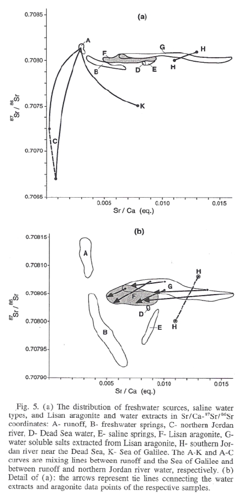
Stein et al. (1997)
examined geochemical differences between the two deposits in order to
better understand the evolution of the Dead Sea water body and this work suggests several
ways to distinguish the deposits including (but not limited to)
- thin section work
- Micro X Ray Fluorescence scanning to look at Trace Element Geochemistry
- Sr87/Sr86 isotope ratios
- Sr/Ca ratios
Once a landslide deposit “signature” is developed, we can search for landslide deposits in the Exodus time window (~1150 BC – ~1560 BC). Of particular initial interest would be the ~1550 BC Jordan Valley Earthquake that may explain the tilted walls and ash layer Kathleen Kenyon identified while digging up Jericho at the end of the Middle Bronze age. Jericho was abandoned for many hundreds of years after this event.
This is also supported by Josephus who reports that Manetho in writing about Egyptian History (in a text that is now lost and only quoted in other peoples works) states that the Exodus occurred in ~1600 BC and coincided with the expulsion of the Hyksos – a semitic people believed to have come from Canaan who ruled Egypt during the 15th dynasty. 1560 BC is 40 years after 1600 BC.
That said, as Exodus is a confounding enigma, I think the entire potential Exodus time window should be searched without presumption.
Landslide caused by Floods
The 1266 AD damming of the Jordan was caused by flooding and the account in Joshua 3 mentions that the flood waters were high when the natural damming occurred. Hence, it would also be useful to look into a flood signature such as from
- increased amounts of the trace element Mn due to increased dilution of the saline upper water body in the Dead Sea causing a change in the oxidation state of Mn
- the Sulfur Cycle (Torfstein, 2008)
- increased aragonite deposition due to an influx of bicarbonates (Stein et. al, 1997)
- palynolgy could also be used since the account in Joshua mentions the time of year (Harvest)