Tel Agol
 Figure 2
Aerial view of tell showing the excavation squares, looking north.
Feig (2021a)
| Transliterated Name | Source | Name |
|---|---|---|
| Tel Agol | Hebrew | תל עגול |
| Tell el-Ajjul, Tell el-Ajyul | Arabic |
- Fig. 1 Location Map from
Feig (2021a)
 Figure 1
Location Map
Feig (2021) - Fig. 2 Aerial View from
Feig (2021a)
Figure 2
Aerial view of tell showing the excavation squares, looking north.
Feig (2021a) - Fig. 2 Aerial View from
Feig (2022)
 Figure 2
The excavation area, looking north.
Feig (2022) - Tel Agol in Google Earth
 Tel Agol
click on image to explore this site on a new tab in Google Earth - Tel Agol on govmap.gov.il
 Tel Agol - blurred for security reasons
click on image to explore this site on a new tab in govmap.gov.il
- Fig. 15 Aerial View of Iron Age
fortifications from Feig (2022)
 Figure 15
Tel ‘Agol’s Iron Age fortifications, looking north.
Feig (2022) - Fig. 16 Plan of Iron Age
fortifications from Feig (2022)
 Figure 16
Tel ‘Agol’s Iron Age fortifications
Feig (2022) - Fig. 6 Aerial View of Stratum III
casemate wall from Feig (2021a)
 Figure 6
Aerial view of Stratum III casemate wall, looking northeast.
Feig (2021a) - Fig. 3 Plans and Sections of
Western squares from Feig (2021a)
 Figure 3
Western squares, plan and sections.
Feig (2021a) - Fig. 4 Plans and Sections of
Eastern squares from Feig (2021a)
 Figure 4
Eastern squares, plan and sections.
Feig (2021a)
- Fig. 3 Plans and Sections of
Western squares from Feig (2021a)
Figure 3
Western squares, plan and sections.
Feig (2021a) - Fig. 4 Plans and Sections of
Eastern squares from Feig (2021a)
Figure 4
Eastern squares, plan and sections.
Feig (2021a)
| Damage Type | Location | Image | Comments |
|---|---|---|---|
| Tilted and partially collapsed walls | outer casemate I-III wall
Figure 3 Western squares, plan and sections. Feig (2021a) |
 Figure 12
Collapsed row of stones on outer casemate wall of Casemate III, looking southeast. Feig (2021a) |
|
| Partially collapsed wall presumed from fallen stones, a broken shelf, and smashed pottery | eastern side of interior of casemate III room - especially the NE corner
Figure 3 Western squares, plan and sections. Feig (2021a) |
 NE corner of Casemate III (aka Storeroom Casemate)
Feig (2021b) 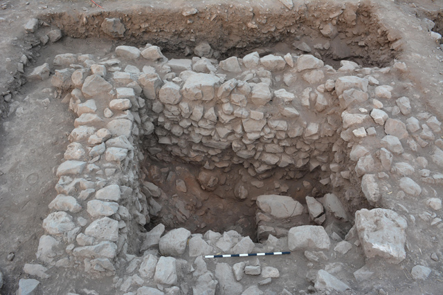 Figure 10
Casemate III, looking southwest. Feig (2021a) |
|
| Fully collapsed and partially collapsed walls | Outer wall and eastern Cross wall of Casemate IV
Figure 4 Eastern squares, plan and sections. Feig (2021a) |
|
- Modified by JW from Fig.s 3 and 4 of Feig (2021a)
 Deformation Map
modified by JW from Fig.s 3 and 4 of Feig (2021a)
- Earthquake Archeological Effects chart
of Rodríguez-Pascua et al (2013: 221-224)
 Earthquake Archeological Effects (EAE)
Rodríguez-Pascua et al (2013: 221-224)
| Damage Type | Location | Image | Comments | Intensity |
|---|---|---|---|---|
| Tilted and partially collapsed walls (i.e. displaced walls) | outer casemate I-III wall
Figure 3 Western squares, plan and sections. Feig (2021a) |
Figure 12 Collapsed row of stones on outer casemate wall of Casemate III, looking southeast. Feig (2021a) |
|
VII+ |
| Partially collapsed wall (i.e. displaced wall) presumed from fallen stones, a broken shelf, and smashed pottery found in fallen position | eastern side of interior of casemate III room - especially the NE corner
Figure 3 Western squares, plan and sections. Feig (2021a) |
NE corner of Casemate III (aka Storeroom Casemate) Feig (2021b)
Figure 10Casemate III, looking southwest. Feig (2021a) |
|
VII+ |
| Fully collapsed and partially collapsed walls | Outer wall and eastern Cross wall of Casemate IV
Figure 4 Eastern squares, plan and sections. Feig (2021a) |
|
VIII+ |