Gezer
 Tel Gezer
click on image to explore this site on a new tab in govmap.gov.il
| Transliterated Name | Source | Name |
|---|---|---|
| Gezer or Tel Gezer | Hebrew | גֶּזֶר |
| Tell Jezar or Tell el-Jezari | Arabic | تل الجزر |
| Ga-az-ru | Assyrian Akkadian | |
| Gazara | ||
| Gadara ? | Josephus |
- from Webster et al. (2023:4-7)
- Number in brackets refer to references in Webster et al. (2023)'s paper
 Fig 2.
Location of the Tandy excavation relative to previous archaeological fieldwork at Gezer.
Image adapted from [41] (front plan) under a CC BY license, with permission from J. Seger, original copyright 2013.
Webster et al. (2023)
Figure 2
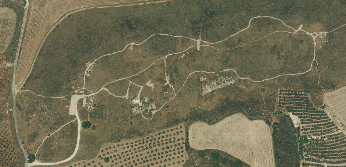
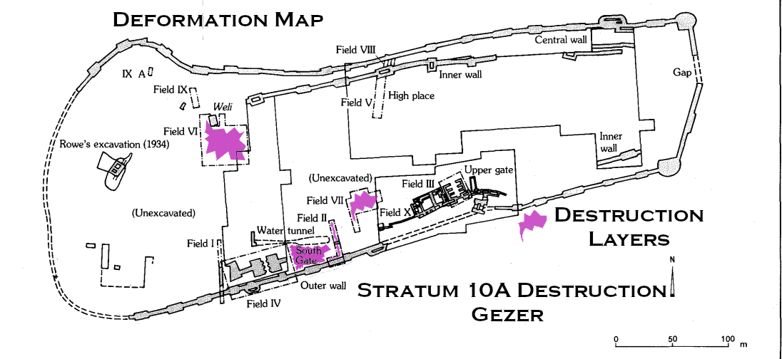
Gezer has been the subject of archaeological fieldwork for over a century, with many parts of the site investigated (Fig 2). Macalister was the first to excavate (1902–1909) [37], but his rudimentary excavation methods seriously limit our ability to integrate the findings into a reconstruction of the site’s history [38]. This is unfortunate, since he excavated nearly 60% of the tell – a fact that leaves few locations available to modern excavators. Nonetheless, Macalister exposed a number of key structures that should be associated with the Late Bronze and Iron Age cities. These include portions of city gates and fortification walls along the southern edge of the site, in the saddle area between Gezer’s western and eastern mounds [37, 39, 40].
Following projects of limited scope by Weill in 1912–1913 and 1923–1924 [42], and Rowe in 1934 [43–45], the next expedition to undertake extensive excavation, this time using careful stratigraphic methods, was by Hebrew Union College (HUC) under the direction of Wright, Dever, Lance and Seger between 1964 and 1974. Remains of the late LBA and Iron Age were explored particularly in Fields II [46, 47], Field III [48, 49], Field VI [50] and Field VII [51, 52]. In the saddle area, Field VII presented the most detailed Iron Age sequence, while Iron II fortification systems and part of an administrative building were explored in Field III. Exploration of features initially exposed but misdated by Macalister revealed six- and four-chambered city gates and a casemate wall.
Dever returned to Gezer for two additional seasons in 1984 and 1990 in an effort to clarify the date of the ‘Outer Wall’ and lower gateway, and to explore the Iron II administrative building west of the six-chambered gate in Field III [53–57].
Fieldwork at Gezer was renewed between 2006 and 2017 by Ortiz and Wolff, focused on creating a wide exposure of the Iron Age city between HUC Fields VII and III (Fig 3). Ten seasons of excavation under the auspices of the Tandy Institute of Archaeology (Southwestern Baptist Theological Seminary) revealed continuous occupation through three strata of the late LBA to Iron I and four of Iron II (cf. [58–61], final publication in preparation) (Table 1). The plans attest to the changing nature of activity near the city gate–sometimes domestic and at other times administrative. Earlier periods (LBA–Iron I) were represented mainly in the western portion of the excavated area, and Iron II in the east. For convenience, the excavation project is referred to throughout this article as the Tandy expedition, but note that during the publication phase the project was moved to the Lanier Center for Archaeology at Lipscomb University.
From 2010–2018, an excavation by Warner, Yannai and Tsuk under the auspices of New Orleans Baptist Theological Seminary (NOBTS) and the Israel National Parks Authority (INPA) revisited Field IV and the adjacent water system. The main goal was to re-expose the water system (previously known to Macalister), clarifying its date (now considered MBA) and how it functioned [62, 63].
Throughout this article, site-wide strata are denoted with Roman numerals and those of single excavation fields with Arabic numerals. The latter refer to the Tandy Expedition except where otherwise specified.
Gezer’s archaeology has played a significant role in many debates related to the chronology of the southern Levant during the late LBA through Iron Age (Table 2). Key issues at Gezer that have remained unclear until recently include:
- The extent and date of destruction at the end of the LBA, which the excavators suggest may be associated with Merneptah. HUC attributed limited burnt remains and smashed pottery in Field II and large-scale trenching in Field VI (the acropolis) with Stratum XV and the end of the LBA [47, 50]; much clearer evidence has now come from the excavations of the Tandy expedition. Still, our ability to securely set the absolute date of the destruction and test the viability of potential historical correlations using solely pottery and finds is severely limited.
- The chronology of so-called ‘Philistine’ material culture [2, 64–72]. Gezer is not a core Philistine-related site, but characteristic pottery appears quite suddenly in Stratum XIII, making up 5% of the relevant pottery assemblage in Fields VI [50] and the Tandy excavation. It first occurs as Philistine 2 (Bichrome) ware, and no indisputable examples of Philistine 1 (Monochrome) are known ([73, 74] contra [75]). A single sherd of Philistine 1 has been identified in the Tandy excavation (S. Gitin, personal communication). Determining the absolute chronology of when ‘Philistine’ influence first reached Gezer is of considerable interest, since it could enhance our understanding of social interactions during the LBA to Iron Age transition.
- The date of the ‘Outer Wall’ and lower gateway to either the LBA or Iron Age [55–57, 76– 82]. The existence or lack of a fortification system at Gezer during the LBA has been vigorously debated, and fortification during the early Iron Age was also unclear until the Tandy expedition.
- The date and political association of monumental building activity in Stratum VIII, with its casemate wall, six-chambered gate and large administrative building. This marked change at Gezer was traditionally dated to the 10th century BC [49, 53–55, 59–61], the gate initially featuring in chronological discussions due to Yadin’s association of six-chambered gates at Gezer, Hazor and Megiddo with 1 Kings 9:15 and Solomonic building activity [39]. The now well-recognised wide distribution of such gates shows that the style was not restricted to a particular kingdom nor were they necessarily built at the same time [83, 84]. Following a low chronology for the Iron I to IIA transition, Finkelstein and others dated Stratum VIII to the 9th century BC and suggested associating it with the northern Israelite kingdom under the Omride dynasty [81, 85–88]. Recent intense archaeological research in the Shephelah shows Gezer Stratum VIII to be part of a pattern indicative of political expansion. Various models have been proposed, and the phenomena is usually seen as the result of westward expansion by Judah or polities based in Jerusalem or the Benjamin plateau [89–93].
- The date and possible historical association for the destruction of Stratum VIII. HUC and the Tandy expedition placed the destruction in the second part of the 10th century BC, drawing an association with Shishak / Sheshonq I. A low chronology scenario, on the other hand, would put the event well inside the 9th century BC, and Finkelstein has suggested associating it with the ca. 830 BC campaign of the Aramaean ruler Hazael [75].
 Table 2
Iron Age chronology of the southern Levant
Webster et al. (2023)
Table 2
- Map of Major Iron Age
sites of the coastal plain, Shephelah, and hill country of Judah from Ortiz and Wolff (2017)
 Figure 2
Major Iron Age sites of the coastal plain, Shephelah, and hill country of Judah.
Ortiz and Wolff (2017) - Location Map from
BibleWalks.com
 The cities and roads around Gezer – during the Canaanite and Israelite periods with Gezer marked as a red point
(Bible Mapper 3.0)
Used with permission from BibleWalks.com - Fig. 1 Location Map
from Webster et al. (2023)
 Fig 1.
Location of Gezer and sites mentioned in the text.
Webster et al. (2023)
- Map of Major Iron Age
sites of the coastal plain, Shephelah, and hill country of Judah from Ortiz and Wolff (2017)
Figure 2
Major Iron Age sites of the coastal plain, Shephelah, and hill country of Judah.
Ortiz and Wolff (2017) - Location Map from
BibleWalks.com
The cities and roads around Gezer – during the Canaanite and Israelite periods with Gezer marked as a red point
(Bible Mapper 3.0)
Used with permission from BibleWalks.com - Fig. 1 Location Map
from Webster et al. (2023)
Fig 1.
Location of Gezer and sites mentioned in the text.
Webster et al. (2023)
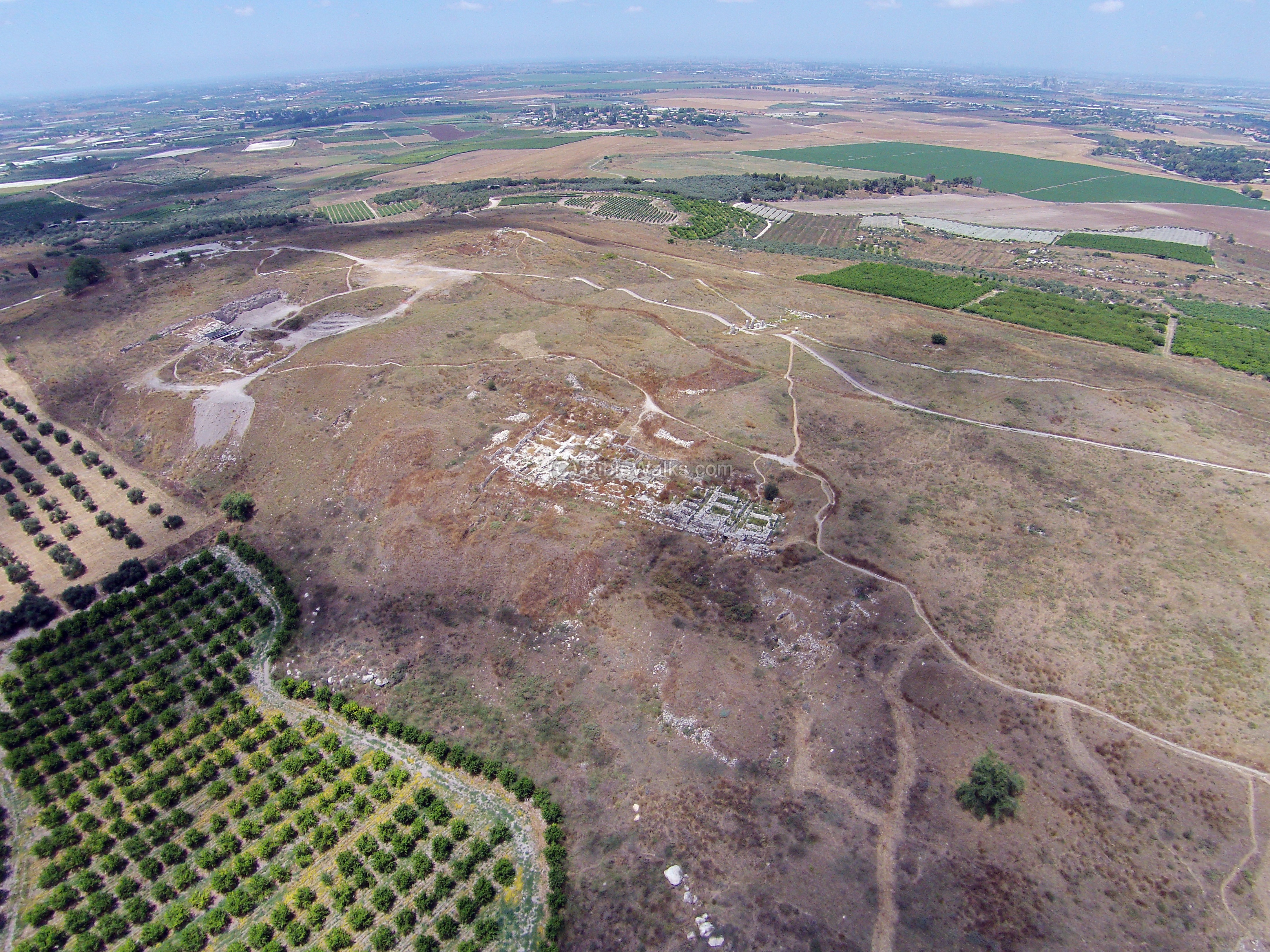
- Oblique Aerial View of Tel Gezer
from BibleWalks.com
 Aerial View of Tel Gezer
Click on Image for high resolution magnifiable image
Used with permission from Biblewalks.com - Annotated Aerial View of
Tel Gezer from BibleWalks.com
- Tel Gezer in Google Earth
 Tel Gezer
click on image to explore this site on a new tab in Google Earth - Tel Gezer on govmap.gov.il
Tel Gezer
click on image to explore this site on a new tab in govmap.gov.il

- Fig. 2 Site plan from
Webster et al. (2023)
Fig 2.
Location of the Tandy excavation relative to previous archaeological fieldwork at Gezer.
Image adapted from [41] (front plan) under a CC BY license, with permission from J. Seger, original copyright 2013.
Webster et al. (2023) - Plan of the mound and
excavation areas from Stern et al (1993 v. 2)
 Gezer: plan of the mound, excavation fields, and principal remains.
Stern et al (1993 v. 3) - Plate 4 - Plan of Tel Gezer
from Younker (1991)
 Plate 4
Plan of Tel Gezer
Younker (1991)
- Fig. 2 Site plan from
Webster et al. (2023)
Fig 2.
Location of the Tandy excavation relative to previous archaeological fieldwork at Gezer.
Image adapted from [41] (front plan) under a CC BY license, with permission from J. Seger, original copyright 2013.
Webster et al. (2023) - Plan of the mound and
excavation areas from Stern et al (1993 v. 2)
Gezer: plan of the mound, excavation fields, and principal remains.
Stern et al (1993 v. 3) - Plate 4 - Plan of Tel Gezer
from Younker (1991)
Plate 4
Plan of Tel Gezer
Younker (1991)
- Plate 19 - Hand drawn plan
of Outer and Inner Walls in Field XI (North Wall) from Younker (1991)
 Plate 19
Detail of Field XI (after Macalister). Note approximate locations of Squares 21 and 22.
Younker (1991) - Plate III.1 - Plan of Inner and
Outer Walls in Field XI from Dever (1992)
 Plate III.1
E/23. Field XI, Areas 20-22
Dever (1992)
- Plate 19 - Hand drawn plan
of Outer and Inner Walls in Field XI (North Wall) from Younker (1991)
Plate 19
Detail of Field XI (after Macalister). Note approximate locations of Squares 21 and 22.
Younker (1991) - Plate III.1 - Plan of Inner and
Outer Walls in Field XI from Dever (1992)
Plate III.1
E/23. Field XI, Areas 20-22
Dever (1992)
- Fig. 3 Photo/Plan of fields
III and VII (South Gate) from Webster et al. (2023)
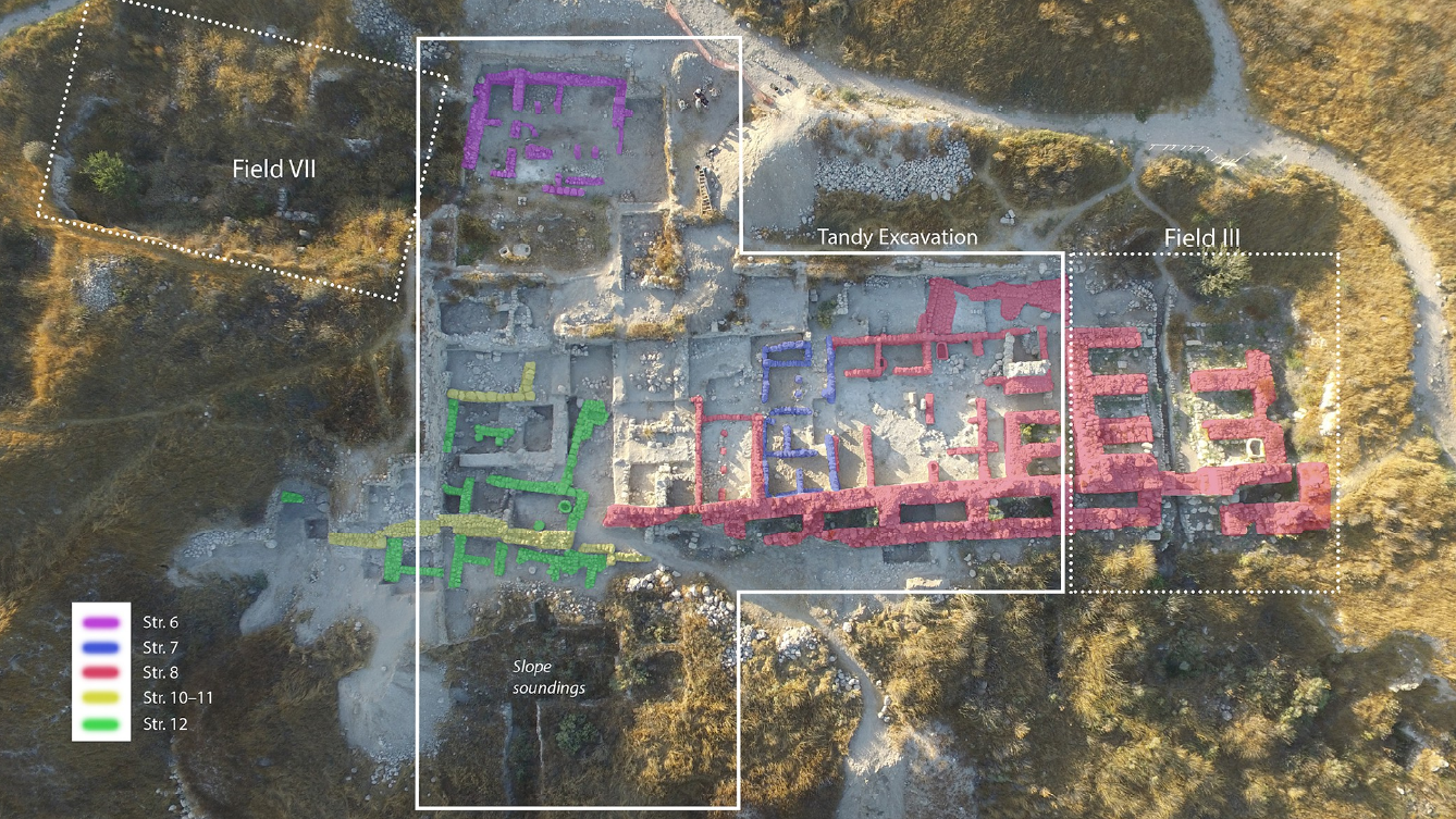 Fig 3
Fig 3
Aerial view of the Tandy excavations, with a wide exposure of iron age strata on the central-southern edge of the Gezer mound between fields VII and III of Hebrew Union College.
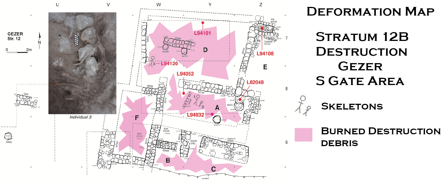
Webster et al. (2023) - Fig. 4 Plan of Stratum 12B
elite residence in South Gate area from Webster et al. (2023)
 Fig 4
Fig 4
Plan of Tandy excavation stratum 12B elite residence with radiocarbon dated contexts marked. The insert shows Individual #3.
Webster et al. (2023) - Fig. 6 Plan of Strata 10A & 9
in South Gate area from Webster et al. (2023)
 Fig 6
Fig 6
Plan of Tandy excavation strata 10A and 9 with radiocarbon dated contexts marked.
Webster et al. (2023) - Fig. 7 Plan of Stratum 8
in South Gate area from Webster et al. (2023)
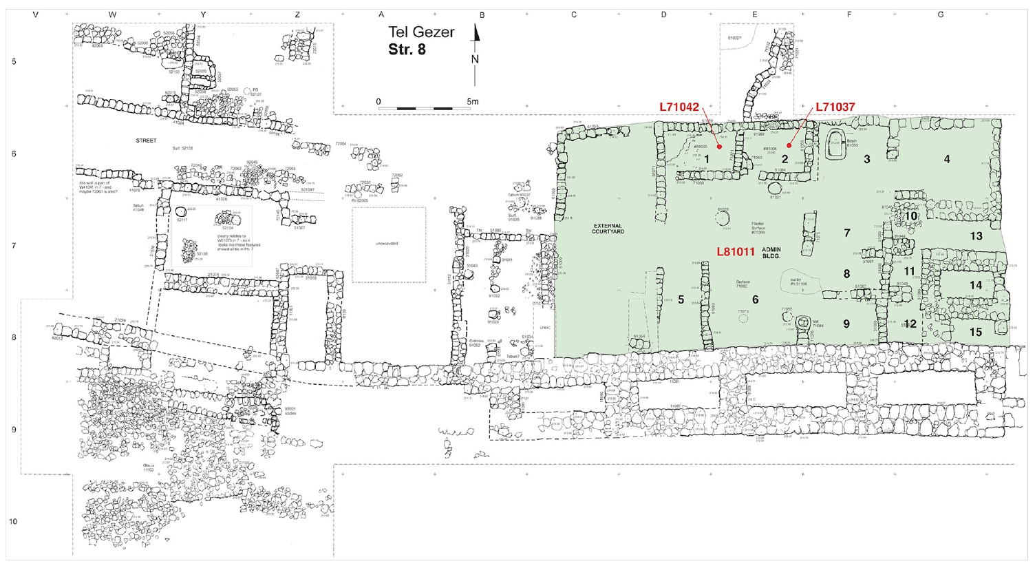 Fig 7
Fig 7
Plan of Tandy excavation stratum 8 with radiocarbon dated contexts in the courtyard-type administrative building marked.
Webster et al. (2023) - Fig. 8 Plan of Stratum 7
in South Gate area from Webster et al. (2023)
 Fig 8
Fig 8
Plan of Tandy excavation stratum 7 domestic units with radiocarbon dated contexts marked.
Webster et al. (2023)
- Fig. 3 Photo/Plan of fields
III and VII (South Gate) from Webster et al. (2023)
Fig 3
Aerial view of the Tandy excavations, with a wide exposure of iron age strata on the central-southern edge of the Gezer mound between fields VII and III of Hebrew Union College.
Webster et al. (2023) - Fig. 4 Plan of Stratum 12B
elite residence in South Gate area from Webster et al. (2023)
Fig 4
Plan of Tandy excavation stratum 12B elite residence with radiocarbon dated contexts marked. The insert shows Individual #3.
Webster et al. (2023) - Fig. 6 Plan of Strata 10A & 9
in South Gate area from Webster et al. (2023)
Fig 6
Plan of Tandy excavation strata 10A and 9 with radiocarbon dated contexts marked.
Webster et al. (2023) - Fig. 7 Plan of Stratum 8
in South Gate area from Webster et al. (2023)
Fig 7
Plan of Tandy excavation stratum 8 with radiocarbon dated contexts in the courtyard-type administrative building marked.
Webster et al. (2023) - Fig. 8 Plan of Stratum 7
in South Gate area from Webster et al. (2023)
Fig 8
Plan of Tandy excavation stratum 7 domestic units with radiocarbon dated contexts marked.
Webster et al. (2023)
- Plate VIII - Map of
the surroundings of Gezer from Macalister (1912 v. 3) (follow link to bigger image)
 Plate VI
Plan of Hellenistic Period [JW: Dever (1992) says this is Iron Age]
Macalister (1912 v. 3) - Plan of the excavations
from Macalister (1912 v. 3)
 Key Plan of the Excavations showing their relation to the area of the city
Macalister (1912 v. 3) - Plate II - Plan of
1st Semitic Period from and according to Macalister (1912 v. 3) (follow link to bigger image)
 Plate III
Plan of 1st Semitic Period
Macalister (1912 v. 3) - Plate III - Plan of
2nd Semitic Period from and according to Macalister (1912 v. 3) (follow link to bigger image)
 Plate III
Plan of 2nd Semitic Period
Macalister (1912 v. 3) - Plate IV - Plan of
3rd Semitic Period from and according to Macalister (1912 v. 3) (follow link to bigger image)
 Plate IV
Plan of 3rd Semitic Period
Macalister (1912 v. 3) - Plate V - Plan of
4th Semitic Period from and according to Macalister (1912 v. 3) (follow link to bigger image)
 Plate V
Plan of 4th Semitic Period
Macalister (1912 v. 3) - Plate VI - Plan of
Hellenistic Period [JW: Dever (1992) says this is Iron Age] from and according to Macalister (1912 v. 3) (follow link to bigger image)
 Plate VI
Plan of Hellenistic Period [JW: Dever (1992) says this is Iron Age]
Macalister (1912 v. 3)
- Plate VIII - Map of
the surroundings of Gezer from Macalister (1912 v. 3) (follow link to bigger image)
Plate VI
Plan of Hellenistic Period [JW: Dever (1992) says this is Iron Age]
Macalister (1912 v. 3) - Plan of the excavations
from Macalister (1912 v. 3)
Key Plan of the Excavations showing their relation to the area of the city
Macalister (1912 v. 3) - Plate II - Plan of
1st Semitic Period from and according to Macalister (1912 v. 3) (follow link to bigger image)
Plate III
Plan of 1st Semitic Period
Macalister (1912 v. 3) - Plate III - Plan of
2nd Semitic Period from and according to Macalister (1912 v. 3) (follow link to bigger image)
Plate III
Plan of 2nd Semitic Period
Macalister (1912 v. 3) - Plate IV - Plan of
3rd Semitic Period from and according to Macalister (1912 v. 3) (follow link to bigger image)
Plate IV
Plan of 3rd Semitic Period
Macalister (1912 v. 3) - Plate V - Plan of
4th Semitic Period from and according to Macalister (1912 v. 3) (follow link to bigger image)
Plate V
Plan of 4th Semitic Period
Macalister (1912 v. 3) - Plate VI - Plan of
Hellenistic Period [JW: Dever (1992) says this is Iron Age] from and according to Macalister (1912 v. 3) (follow link to bigger image)
Plate VI
Plan of Hellenistic Period [JW: Dever (1992) says this is Iron Age]
Macalister (1912 v. 3)
- Artist's Rendition of Gezer
during the Iron Age from BibleWalks.com
 Artist's Rendition of Gezer during the Iron Age. View from the South.
Used with permission from BibleWalks.com
 Table 1
Stratigraphy of the Gezer Tandy excavation, with reference to HUC (Hebrew Union College) stratigraphy.
Webster et al. (2023)
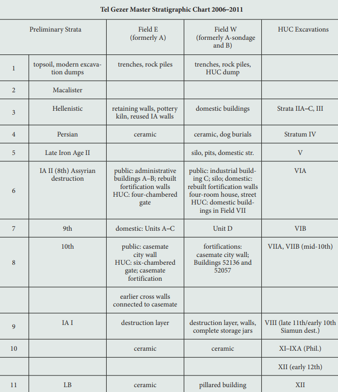
 Figure 10A
Bayesian 14C model A for the Tandy excavation
The models use OxCal’s outlier analysis. Model A includes all data.
- Individual probability distributions before and after modelling are shown in light and dark grey respectively.
- Calculated transition boundaries are colored green, while date estimates for strata are red.
- Highest posterior density (hpd) ranges after modelling (68.3% and 95.4%) are marked with bars below each result.
- Prior and posterior outlier probabilities are indicated in square brackets after the laboratory number and locus.
- The OxCal code is provided in S1 Appendix.
Webster et al. (2023)
 Figure 10B
Bayesian 14C model B for the Tandy excavation
The models use OxCal’s outlier analysis. Model B excludes two outliers in Tandy Stratum 8 (Beta-436538 and Beta-436540).
- Individual probability distributions before and after modelling are shown in light and dark grey respectively.
- Calculated transition boundaries are colored green, while date estimates for strata are red.
- Highest posterior density (hpd) ranges after modelling (68.3% and 95.4%) are marked with bars below each result.
- Prior and posterior outlier probabilities are indicated in square brackets after the laboratory number and locus.
- The OxCal code is provided in S1 Appendix.
Webster et al. (2023)
Figure 10Bayesian 14C models (A and B) for the Tandy excavation
The models use OxCal’s outlier analysis. Model A includes all data. Model B excludes two outliers in Tandy Stratum 8 (Beta-436538 and Beta-436540).
- Individual probability distributions before and after modelling are shown in light and dark grey respectively.
- Calculated transition boundaries are colored green, while date estimates for strata are red.
- Highest posterior density (hpd) ranges after modelling (68.3% and 95.4%) are marked with bars below each result.
- Prior and posterior outlier probabilities are indicated in square brackets after the laboratory number and locus.
- The OxCal code is provided in S1 Appendix.
Webster et al. (2023)
 Figure 11
Comparison of 14C dated transitions at Gezer with key data from nearby sites and the Egyptian chronology.
The 14C - based Egyptian chronology follows Dee [3] and Manning [4] and is updated with IntCal20 [137]. It assumes the ultra-high reign lengths of Aston [144] for Thutmoses III through Ramesses II and reign lengths from Schneider [145] for all others. Absolute date estimates based on traditional methods are shown for Schneider (same line as the 14C - based estimates) and Kitchen [146] (separate line below). Key results from sites neighboring Gezer are colored brown. Source models and data references for these sites are provided in S1 Appendix.
Webster et al. (2023)
 Table 3
Radiocarbon dates from the Tandy excavation at Tel Gezer.
All measurements were made on charred seeds, with the exception of SANU-60015 (bone collagen). Adjacent pairs of results marked with an asterisk (*) were measured on the same seed. hpd = highest probability density.
Webster et al. (2023)
- from Fall et al. (2023)
 Table 1
Traditional and revised Early and Middle Bronze Age chronologies for the Southern Levant. (Traditional chronology based on Dever 1992; Levy 1995:fig. 3; revised chronology based on Regev et al. 2012; Fall et al. 2021; Höflmayer and Manning 2022.)
Fall et al. (2023)
- Fig. 3 Photo/Plan of fields
III and VII (South Gate) from Webster et al. (2023)
Fig 3
Aerial view of the Tandy excavations, with a wide exposure of iron age strata on the central-southern edge of the Gezer mound between fields VII and III of Hebrew Union College.
Webster et al. (2023) - Fig. 4 Plan of Stratum 12B
elite residence in South Gate area from Webster et al. (2023)
Fig 4
Plan of Tandy excavation stratum 12B elite residence with radiocarbon dated contexts marked. The insert shows Individual #3.
Webster et al. (2023)
- Fig. 3 Photo/Plan of fields
III and VII (South Gate) from Webster et al. (2023)
Fig 3
Aerial view of the Tandy excavations, with a wide exposure of iron age strata on the central-southern edge of the Gezer mound between fields VII and III of Hebrew Union College.
Webster et al. (2023) - Fig. 6 Plan of Strata 10A & 9
in South Gate area from Webster et al. (2023)
Fig 6
Plan of Tandy excavation strata 10A and 9 with radiocarbon dated contexts marked.
Webster et al. (2023)
- Fig. 3 Photo/Plan of fields
III and VII (South Gate) from Webster et al. (2023)
Fig 3
Aerial view of the Tandy excavations, with a wide exposure of iron age strata on the central-southern edge of the Gezer mound between fields VII and III of Hebrew Union College.
Webster et al. (2023) - Fig. 7 Plan of Stratum 8
in South Gate area from Webster et al. (2023)
Fig 7
Plan of Tandy excavation stratum 8 with radiocarbon dated contexts in the courtyard-type administrative building marked.
Webster et al. (2023)
- Fig. 3 Photo/Plan of fields
III and VII (South Gate) from Webster et al. (2023)
Fig 3
Aerial view of the Tandy excavations, with a wide exposure of iron age strata on the central-southern edge of the Gezer mound between fields VII and III of Hebrew Union College.
Webster et al. (2023) - Fig. 8 Plan of Stratum 7
in South Gate area from Webster et al. (2023)
Fig 8
Plan of Tandy excavation stratum 7 domestic units with radiocarbon dated contexts marked.
Webster et al. (2023)
- Plate 4 -
Plan of Tel Gezer from Younker (1991).
Plate 4
Plan of Tel Gezer
Younker (1991) - Plate 19 -
Hand drawn Plan of Outer and Inner Walls in Field XI from Younker (1991)
Plate 19
Detail of Field XI (after Macalister). Note approximate locations of Squares 21 and 22.
Younker (1991) - Plate 15a -
Photo of Outer Wall and destruction layer (Macalister's "Tower VII") from Younker (1991)
 Plate 15a
JW:- Top - ashlars of outer wall
- Floor - 8th cent. BCE destruction layer
Younker (1991) - Plate 15b -
Annotated Sketch of Outer Wall with destruction layer (Macalister's "Tower VII") from Younker (1991)
 Plate 15b
- Outer face offset of Outer Wall built in 10th cent. BCE
- 8th cent. BCE destruction layer
Younker (1991) - Plate 16a -
Photo of Outer Wall with with through-going joints across stones (Macalister's "Tower VI") from Younker (1991)
 Plate 16a
JW: Outer Wall with through-going joints across stones
Younker (1991) - Plate 16b -
Annotated Sketch of Outer Wall with destruction layer (Macalister's Tower VI) from Younker (1991)
 Plate 16b
- Inner face offset of Outer Wall (Macalister's "Tower VI") founded in 10th cent. B.C.
- Remodelled, and destroyed by earthquake in 8th cent. B.C
Younker (1991)
- Figure 13 -
Plan of Field XI East from Dever (1993)
 Figure 13
General Plan of Field XI East showing 1990 excavation areas; note line of Sections β-β', γ—γ' (cf. fig. 14).
Dever (1993) - Figure 16 -
Section γ—γ' through Outer Wall in Field XI from Dever (1993)
 Figure 16
Schematic rendering of Section γ—γ' through Outer Wall in Field XI, Areas 21 and 22; cf. fig. 13.
Dever (1993) - Figure 14 -
Tilted Wall and through-going cracks in Ashlars from Dever (1993)
 Figure 14
Field XI, Area 20, looking east. Note collapsed line of Outer Wall all along left; in center, cracked offset portion; and, at right, two foundation trenches through Middle Bronze glacis (Section β-β').
Dever (1993) - Figure 15 -
Wall displacement from Dever (1993)
 Figure 15
Line of Outer Wall between Field XI, Areas 20 and 21, looking west. Note wall stones still in alignment, but displaced northward, downslope, cf. fig. 14.
Dever (1993) - Figure 17 -
LB II and tilted Iron Age Wall from Dever (1993)
 Figure 17
Field XI, Area 22, looking south, with Section α—α' to right. Below meter stick is LB II Wall 22,002, founded on bedrock; above is Iron Age Wall 22,000, partially plastered. Note differing masonry, offset alignment; cf. fig. 16 for Section γ—γ'.
Dever (1993)
- from Younker (1991)
- Plate 4 - -
Plan of Tel Gezer from Younker (1991).
Plate 4
Plan of Tel Gezer
Younker (1991) - Plate 19 - -
Hand drawn Plan of Outer and Inner Walls in Field XI from Younker (1991)
Plate 19
Detail of Field XI (after Macalister). Note approximate locations of Squares 21 and 22.
Younker (1991) - Plate 6 - -
Plan of "Egyptian Governor's Residency" (Field XI) from Younker (1991)
 Plate 6
Plan of "Egyptian Governor's Residency" (Field XI)
Younker (1991) - Plate 14a - -
Photo of Excavation of inner face of outer wall (Macalister's "Tower VII") from Younker (1991)
 Plate 14a
JW:- Bottom Stones - Inner face of Outer Wall founded in 8th cent. B.C.
- Top 3 stones - rebuilt wall from Hellenistic times
Younker (1991) - Plate 14b - -
Drawing of Excavation of inner face of outer wall (Macalister's "Tower VII") from Younker (1991)
 Plate 14b
- Inner face of Outer Wall founded in 8th cent. B.C.
- rebuilt in Hellenistic times
Younker (1991) - Plate 15a - -
Photo of outer face of outer wall and destruction layer (Macalister's "Tower VII") from Younker (1991)
Plate 15a
JW:- Top - ashlars of outer wall
- Floor - 8th cent. BCE destruction layer
Younker (1991) - Plate 15b - -
Annotated Sketch of outer face of outer wall with destruction layer (Macalister's "Tower VII") from Younker (1991)
Plate 15b
- Outer face offset of Outer Wall built in 10th cent. BCE
- 8th cent. BCE destruction layer
Younker (1991) - Plate 16a - -
Photo of outer wall with with through-going joints across stones (Macalister's "Tower VI") from Younker (1991)
Plate 16a
JW: Outer Wall with through-going joints across stones
Younker (1991) - Plate 16b - -
Annotated Sketch of outer wall with through-going joints across stones (Macalister's "Tower VI") from Younker (1991)
Plate 16b
- Inner face offset of Outer Wall (Macalister's "Tower VII") founded in 10th cent. B.C.
- Remodelled, and destroyed by earthquake in 8th cent. B.C
Younker (1991)
3. Results in Field XI
...
Macalister's Tower VII
According to Macalister, a number of ashlar towers had been inserted into the Late Bronze Age Outer Wall by Solomonic engineers.13 In order to test this claim it was decided to locate his "Tower VII" (situated immediately north of the "Egyptian Governor's Residency," according to Macalister's plan) and open two soundings — one against each of the inner and outer faces of the "tower" — in order to determine if indeed the "towers" were constructed in the manner and at the time Macalister claimed (see Plates 4, 6, and 19).
After clearing off the top of the Outer Wall, however, it was discovered that Macalister's "Tower VII" was not a tower at all, but rather an offset that was similar to what he found further west in his trenches 22-29, a stretch of wall which he described as "rebuilt."14 Macalister had apparently found the same corner as our team and had simply drawn in the other three corners on his plan.
Excavation against the inner face of the "tower" reached bedrock in just over a meter (Plate 14). A foundation trench, which showed up clearly in the eastern balk, indicated that the offset was initially constructed in the 8th century B.C. Later, during the Hellenistic period, a second trench had been dug into the earlier one, suggesting that at least part of the wall was rebuilt during this period. Indeed, the ashlars in the upper two or three courses of the wall were poorly laid. They were uneven and not in the header-stretcher fashion. Thus they were probably reused from the earlier Iron Age construction.
The fact that the earliest architectural phase of the offset dated no earlier than the 8th century B.C. would seem to raise doubts about the claims of those who have argued for an earlier dating of the Outer Wall. However, excavation along the outer face of "Tower VII" revealed at least nine courses (ca. 5 m.) of excellent header-stretcher masonry.15 Although bedrock could not be reached in this sounding, the pottery from the lowest level of fills against the outer face consisted of red-slipped 10th century B.C. wares.
Above these 10th century fills (which were more than 2 m. thick) were at least two plastered surfaces which ran up against the wall face. The debris on these surfaces included fallen ashlar blocks in a bricky fill containing 8th century B.C. sherds. The debris layers may be evidence of both an earlier 8th century earthquake (see below) and a later 8th century B.C. Assyrian destruction (Plate 15). The latter was followed much later by a hasty repair and rebuild, probably during the Maccabean period (2d century B.C.).
Thus, based on the results of the excavation along the outer face of "Tower VII," it appears that the Outer Wall was originally constructed at least by the 10th century B.C., and probably earlier. The discoveries in Square 22 to the east (see below) even suggest the possibility of an initial construction in the LB II. Engineers of the Iron II and Hellenistic periods apparently found it necessary to repair isolated sections of the inner face (which rested on the top of an escarpment), thus leading to the discrepancy between the dates for the construction of the inner and outer faces of the Outer Wall.
Macalister's Tower VI
In the hope of finding a genuine Solomonic tower inserted into a Late Bronze Age wall, it was decided to move east and attempt to locate Macalister's "Tower VI." According to Macalister's top plan, Tower VI was located between 25 m. and 30 m. east of Tower VII (Plate 19). Using the bulldozer to clear away Macalister dump and post-Macalister debris accumulation (which included some 1947 Jordanian army trenches), it was not long before an ashlar block of what appeared to be the southwest corner of Macalister's Outer Wall Tower VI was uncovered.
Unfortunately, excavations indicated that this "tower" was also only an offset (Plate 16). However, the pottery from the foundation trench16 indicated that the earliest phase of this stretch of the Outer Wall was founded probably during the 10th century B.C. Two additional pieces of evidence also support a 10th century B.C. dating. First, a stone of the lowest course of the inner face of the Outer Wall is roughly bossed in a fashion typical of foundation ashlars of the 10th century. Second, this lowest course is clearly cut by the later "tower" or offset, indicating that this stretch of the wall preceded the construction of the "tower." Since the "inserted tower" dated to the 9th/8th century B.C. (see below), the wall must be dated earlier. While this second line of evidence is not sufficient by itself to provide a 10th century date, the bossed ashlar and the 10th century trench combine to make a 10th century B.C. date for this section of the wall most probable.
Sometime during the 9th/8th century B.C. the upper courses of the Outer Wall were remodelled with large ashlars to create an offset.17 The ashlar offset was "inserted" more than a meter into the 10th century B.C. wall line.18
The 9th/8th century ashlar inserts and wall appear to have been destroyed sometime during the 8th century B.C. Several lines of evidence suggest that the agent of destruction was an earthquake. For one thing, several sections of the Outer Wall had been clearly displaced from their foundations by as much as 10 to 40 cm. Furthermore, these wall sections were all severely tilted outward toward the north. That this tilting was not due to slow subsidence over a long period of time was evident from the fact that intact sections of upper courses of the inner face of the wall had fallen backwards into the city. Only a very rapid outward tilting of the wall, such as that caused by an earthquake, could cause these upper stones to roll off backwards, away from the tilt. If the wall's outward tilt had occurred slowly, the stones on the top of the wall should have fallen off toward the downward-sloping outer face of the wall.
The southwest corner of the ashlar insert had been similarly displaced from its foundational cornerstone, although to a lesser degree because of the greater stability of the ashlar construction. However, even the cornerstone had been split longitudinally because of the great pressure created by the lateral movement of the upper courses. This same tremendous pressure also created fissures in the ashlar stones that penetrated through several courses. The reason the foundation stones were not themselves dislodged to any significant degree is probably due to the fact that they were set into levelled-out depressions cut directly into the bedrock.
Evidence for an 8th century B.C. earthquake has been discovered at several other sites, such as Hazor.19 It is not impossible that the wall was destroyed by the well-known earthquake of Amos 1 and Zech 14:5 (ca. 760 B.C.).20
- from Dever (1992)
- Plate III.1 - -
Plan of Inner and Outer Walls in Filed XI from Dever (1992)
Plate III.1
E/23. Field XI, Areas 20-22
Dever (1992) - Plate III.2 - -
Outer face of the "Outer Wall" from Dever (1992)
 Plate III.2
Outer face of the "Outer Wall" in Field XI, Area 18, showing the offset and upper ashlar courses, with several displaced ashlar blocks lying on and above an 8th century BCE surface; at least three ashlar courses lie below.
Photo: W.G. Dever
Dever (1992) - Plate III.3 - -
Cracked "Outer Wall" from Dever (1992)
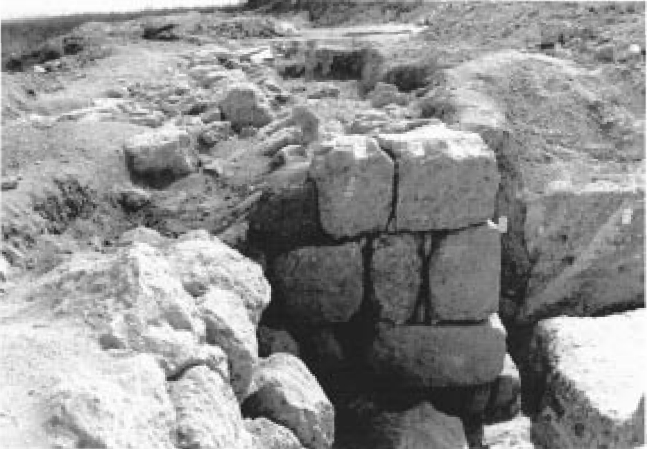 Plate III.3
The "Outer Wall" in Field XI, Area 20, looking east. Note the Middle Bronze glacis, cut by two successive Iron Age foundation trenches; ashlar offset with cracked stones; in foreground, detached and tilted masonry upper courses, with bottom course still in situ on scarped bedrock; in background, further stretch of wall, radically displaced from line of offset/"tower".
Photo: W.G. Dever
Dever (1992) - Plate III.4 - -
Laterally Displaced "Outer Wall" from Dever (1992)
 Plate III.4
"Outer Wall" between Areas 20 and 21 of Field XI. looking north/northwest (over wall top, toward valley below). Note how the wall has pulled apart and collapsed downslope, yet with portions of large boulders still segmented.
Photo: W.G. Dever
Dever (1992)
C. The 1990 Season at Gezer: Iron Age Fortifications and Their Destruction
The 1990 season of excavation at Gezer was planned deliberately to follow up the 1984 season — both focusing on the question of the precise date and character of the Iron Age defenses. These defenses had become the object of heated controversy following the close of the original excavations in 1964-1973 and the subsequent publication of several volumes of final field reports. The details of both the controversy and of the results of the 1984/ 1990 excavations have been published extensively elsewhere and need not detain us here.12 We shall concentrate rather on the evidence for earthquake destruction in Field XI in the 1990 season.
After having investigated Macalister's "Outer Wall" — which we have consistently dated to LB II, with an Iron Age reuse phase beginning in the 10th century BCE — in several fields over the years, we opened in 1990 a large new area along the north perimeter, designated Field XI. This field is located ca. 35-55 m east of the Field V "High Place", straddling both the Middle Bronze "Inner Wall" and the disputed "Outer Wall" and exposing portions of both (Fig. III.1).13
To the west of Field VI, in Areas 9, 10, 15, 16, 18, the "Outer Wall" was a splendidly constructed and well-preserved structure, still standing as much as nine courses and ca. 5 m high. It was set into a deep, backfilled foundation trench along the inner face (cutting the Middle Bronze glacis), founded on or just above bedrock, and constructed of roughly cut ashlar blocks. Along the outer face, where bedrock sloped sharply downhill, the wall stood at least six courses high (we did not reach the founding level) in all-ashlar masonry that was superbly drafted and fitted (Fig. III.2).
This portion of the city wall at first appeared to be one of Macalister's "inserted towers" (in fact, his "no. vii"),14 which both he and myself had regarded as secondary Iron Age additions to an original Late Bronze Age defense wall — in this case, probably 10th century BCE on the basis of the cumulative evidence elsewhere.15 However, since the inner face revealed only a backfilled foundation trench with no preserved living surfaces, and the trench along the outer face could not be driven to founding levels, we had no independent dating evidence here. We did isolate a destruction layer about halfway up the outer face, with a fall of partially broken and displaced ashlar blocks, fallen onto a surface dated by some clear 8th century BCE sherds, probably evidence of the Assyrian destruction so dramatically revealed elsewhere.16 But the date of the construction of the "Outer Wall" here can only be posited by extrapolation, i.e., it must be pre-733 BCE. Whatever the precise date, however, and regardless of whether this portion is indeed "inserted," this stretch of the "Outer Wall" is definitely not a tower. It is more likely a section of an offset-inset wall — precisely as Macalister himself correctly noted much farther to the west, in a section that he marked "rebuilt" on the Plan of his "Hellenistic" (although it is Iron Age) stratum." It is perhaps noteworthy that offset-inset walls, with their "break-joints" at regular intervals, are presumed to be intended as anti-earthquake devices. (If so, they may indeed have been effective here.)
Farther east in Field VI, especially in Area 32, the "Outer Wall" exhibits a rather different character (Fig. III.3). Here the wall had evidently also been set into a similar backfilled foundation trench, dated possibly by a few 10th century BCE sherds. A secondary trench, however, dated by several 9th/8th century BCE sherds, reached all the way to bedrock, which was now scarped to receive a foundation course of rough ashlar blocks, found still in situ. Above these were two more courses of very large, roughly hewn squared stones, very different from the smaller, finely dressed rectangular blocks in the wall to the west (above). Here, too, there was an offset along the inner face that Macalister had mistakenly interpreted as a "tower" (his "no. vi").18
While the two Iron Age phases in the "Outer Wall" were so crystal clear in the sections that they constituted a "textbook" example of stratigraphy, of more interest was the evidence they preserved of an earthquake destruction of the second, 9th/8th century BCE phase. The evidence was twofold.
- First, all three courses of the large rectangular blocks just at the "tower" offset were cracked clear through, from top to bottom, the heavy stones still approximately in place but with a large open gap running from top to bottom (Fig. III.3).
- Second, immediately to the west of the "tower" offset, the foundation course (here of marginally drafted ashlars) was still in situ; but the upper two courses of rougher boulders were found radically displaced upward and outward, but still lying in a row — as though they had violently "jumped" off their foundations (Figure III.4).
For some time I resisted the suggestions of various staff members that perhaps an earthquake was the best explanation. And certainly I — not identifying with traditional "biblical archaeology" — did not have the earthquake of Amos or Zachariah in mind, despite the 9th/8th century BCE date for the wall that we had posited on quite independent archaeological grounds. Nor at the moment did I recall Yadin's earthquake hypothesis at Hazor. Yet, in the end, the evidence seemed overwhelming. Several of our group from California, including Associate Director Randy Younker, had personally seen just such earthquake damage, even to the fact that random areas of the wall had been affected, and this seemed to provide the confirmation that we needed.
A final probe still farther east, in Area 20, yielded further evidence. Here we cleared a stretch of the same wall for some 15 m. At first, our efforts to trace the wall eastward failed. Because we were following the projected line from the "tower" offset on a straight course and had found no stones, we supposed that the top course was robbed out. To our surprise, we later discovered what was clearly the line of the top course curving radically, a long section bowed outward yet still intact. Furthermore, the tops of the whole line of stones were tilted outward at an angle of ca. 10-15 degrees (Figure III.4).
One could, I suppose, argue that here we are dealing simply with subsidence, perhaps because the bedrock dipped downward at this point (as indeed it did). A more reasonable explanation, however, would seem to be an earthquake that displaced the whole section bodily, especially as the foundations were already weak. Certainly a battering ram, or the work of sappers, could not have produced such a peculiar phenomenon as this whole stretch of wall tipped outward. It does indeed resemble rather closely one of Schaeffer's toppled walls at Ugarit.19
- Figure 1 - -
Through-going joints in ashlars of Outer Wall from Dever and Younker (1991)
 Figure 1
Tel Gezer, Field XI, Area 20: Offset portion of 'Outer Wall' set into the glacis (at right). Note cracks through ashlars at offset, and the wall on both sides of the offset displaced downslope.
Dever and Younker (1991) - Figure 2 - -
Lateral displacement of Outer Wall from Dever and Younker (1991)
 Figure 2
Tel Gezer, Field XI, Area 20: 'Outer Wall' (view to the north-west). Note the wall stones displaced and tilted outward, downslope.
Dever and Younker (1991)
The `Canaanite Castle' and the `Outer Wall'
Objectives 2 and 3 were achieved in newly-opened Field XI (approximately 60 m. east of the Field V `High-Place), encompassing the `Canaanite Castle' and both the lines of the `Inner' and `Outer Walls' at this point.
...
Directly north of the `Castle', the `Outer Wall' was found, built in places directly on bedrock; its cyclopean tower at that point had been incorporated into the later `Castle', probably surviving only as a wall stub and utilized as a cobbled area. Further north and downslope, the `Outer Wall' was encountered, as hoped, running approximately 4.50 m. wide, preserved up to nine courses and 5.00 m. high, also founded mostly on bedrock. What was described and planned by Macalister as his `inserted tower vii', however, turned out to be simply an offset portion of the wall — comparable, for instance, to the portion of the `Outer Wall' further west, marked on his plans as `Rebuilt.' Apparently Macalister mistakenly reconstructed a tower because he dug only one corner and extrapolated the rest on the basis of the true towers he had found elsewhere in this wall. Nonetheless, his observation that this section has a secondary construction phase is essentially correct, because the upper two or three courses along the inner face (all he saw) are indeed a Hellenistic rebuild, re-using the original ashlar blocks. (We were similarly fooled in 1967-1971 by a Maccabean repair of the entryway of the Field III gate.) The outer face of the offset portion proved a surprise, for, in contrast to the tour courses resting on bedrock along the inner face, the wall here was found to go down at least nine courses (or approximately 5.00 m.) in excellent header-stretcher ashlar masonry. We could not, in fact, reach the founding level, but it is probably on bedrock a few more courses down. The pottery from the lowest level of the fills against this outer face consisted of red-slipped tenth-century B.C.E. ware, but no datable living surfaces were found this deep. At around the upper third of the wall face, however, a plaster surface was encountered; just above this there were several displaced and broken ashlar blocks, in a bricky layer containing some eighth-century B.C.E. sherds. Thus, we may have evidence for an Assyrian destruction of the `Outer Wall', followed later by a hasty Maccabean rebuild.
To broaden our exposure, we moved some 30-40 m. to the east and there opened several trenches both inside and outside the 'Outer Wall'. The inner trenches revealed that here the wall had two Iron Age phases. The original wall (Loci 21013/22000) was cut through the Middle Bronze Age chalk glacis, showing a very clear foundation trench back-filled with churned-up glacis material and containing no sherds later than the tenth century B.C.E. This wall was preserved three to four courses high (five to six at the outer face) and was approximately 5.50 m. wide. Directly above this rather poorly-constructed stone wall ran a better built wall (Locus 21000), set back slightly and preserved some three courses or approximately 1.00 m. high. Here, too, the `tower' we expected to find (Macalister's `tower vi') turned out to be simply an offset portion of ashlar masonry (Fig. 1). This later wall, dated by eighth-century B.C.E. sherds in the secondary back-filled trench, was probably destroyed by the well-known earthquake of Amos 1 and Zech. 14:5, c. 760 B.C.E. Not only was the ashlar `tower' cracked from top to bottom and the adjoining boulders violently thrown off their foundations, but a long stretch of the wall to the east was tilted sharply outward in one piece. (Fig. 2). Preliminary research indicates that the Gezer—Ramla region has been subject to repeated earthquake damage in historical times; an earthquake hypothesis, therefore, seems plausible.
The most dramatic evidence came, however, from the cut against the external face of the `Outer Wall' here. Below the two Iron Age phases and founded directly on the sharply sloping bedrock, stood a superbly-constructed wall of roughly-dressed stones, Wall 22002, preserved eight or nine courses and approximately 3.75 m. high (Fig. 3). The first Iron Age wall (tenth century B.C.E.) stood directly atop this wall, but it was offset around 65 cm. and was built of much inferior masonry. At this juncture, a sloping plastered surface created a kind of `glacis' (Locus 22003), associated with later levels of the Iron Age wall (c. ninth century B.C.E.) and clearly going over the top of the earlier wall (i.e., the builders used the stub of the earlier wall simply as a footing). Sealed beneath this glacis was a series of fills, the latest sherds of which were tenth century B.C.E.; below that there was another series of sloping fills. From these deeper fills — running down the lower wall face almost to bedrock and founding levels — came 35 baskets of pottery with nearly pure LB II forms, i.e., with virtually no MB sherds and no Iron Age sherds whatsoever. We conclude that this lowest phase of the `Outer Wall' must have been built in the LB II, and survived to form the foundation for Iron Age Wall 21013/22000. It is noteworthy that the two phases of the `Outer Wall' here in Field VI duplicate almost exactly our finds in Field III in 1984 (and in several other fields previously).
With the results of the 1990 season — a considerably larger exposure of the `Outer Wall' and even clearer evidence of multiple phasing — we consider the controversy over its date settled. We have responded to our critics with two seasons of excavations devoted exclusively to this problem; having produced a mass of new data corroborating our original dating, the burden of proof would now seem to be on the opponents of our views.
- from Dever (1993)
- Figure 13 - -
Plan of Field XI East from Dever (1993)
Figure 13
General Plan of Field XI East showing 1990 excavation areas; note line of Sections β-β', γ—γ' (cf. fig. 14).
Dever (1993) - Figure 14 - -
Tilted Wall and through-going cracks in Ashlars from Dever (1993)
Figure 14
Field XI, Area 20, looking east. Note collapsed line of Outer Wall all along left; in center, cracked offset portion; and, at right, two foundation trenches through Middle Bronze glacis (Section β-β').
Dever (1993) - Figure 15 - -
Wall displacement from Dever (1993)
Figure 15
Line of Outer Wall between Field XI, Areas 20 and 21, looking west. Note wall stones still in alignment, but displaced northward, downslope, cf. fig. 14.
Dever (1993) - Figure 16 - -
Section γ—γ' through Outer Wall in Field XI from Dever (1993)
Figure 16
Schematic rendering of Section γ—γ' through Outer Wall in Field XI, Areas 21 and 22; cf. fig. 13.
Dever (1993) - Figure 17 - -
LB II and tilted Iron Age Wall from Dever (1993)
Figure 17
Field XI, Area 22, looking south, with Section α—α' to right. Below meter stick is LB II Wall 22,002, founded on bedrock; above is Iron Age Wall 22,000, partially plastered. Note differing masonry, offset alignment; cf. fig. 16 for Section γ—γ'.
Dever (1993)
Field XI
...
The "Earthquake" Section. Some 25-35 m east of the portion of the Outer Wall just described (fig. 13), we opened another area to see whether the ashlar offset/inset section continued. Here, in Area 20, was another, similar offset that Macalister had published as a "tower" (his "no. vi"). Also similar, but more certain, was the evidence for multiple phasing (see fig. 14 for the following).
- Here the MB II glacis was well preserved, exhibiting the same alternating tell debris and chalk layering, with "tongues" keying the sloping plaster into the core, that we had found earlier in Fields I and III.23
- The Outer Wall was set into a very clearly visible foundation trench, cut through the glacis to bedrock and backfilled with churned-up glacis material, exactly as it had been to the west. The single foundation course was of roughly dressed, bossed ashlars set directly upon the bedrock, which was scarped to receive it. A few tenth century B.C.E. sherds in the largely sterile fill of the foundation trench might date the construction phase.
- Here, too, there was a secondary Iron Age addition, in this case an upper three courses of very large, square hammer-dressed stones at the offset, with undressed boulders elsewhere. The secondary trench for those courses was easily discernible, since it cut through the chalk-filled original trench and was filled only with soft brown, featureless soil. A few ninth/eighth century B.C.E. sherds suggest a date, but the evidence is scant.
- The upper three courses showed evidence of violent destruction: the squared stones of the offset were cracked through from top to bottom; and the undressed boulders seemed to have "jumped off" the foundation course of bossed ashlars and had been radically displaced upward and outward, downslope. This evidence suggested to us earthquake disturbance (below).
- There was no clear evidence of a Maccabean repair and reuse.
The evidence here, taken together with that of Area 20 to the west, is probably best explained by positing an earthquake that severely damaged the wall. Since the upper (offset/inset) phase seems to have been built in the ninth/eighth centuries B.C.E., the best candidate would be the well-known earthquake mentioned in Amos 1:1 and Zechariah 14:5, dated by reference to the reigns of Jeroboam of Israel (ca. 786-744 B.C.E.) and Uzziah of Judah (ca. 786-746 B.C.E.), and thus perhaps falling ca. 760 B.C.E.
Yadin had found similar evidence of tilted and toppled walls at Hazor in Stratum VI of Area A, corroborated by Ben-Tor in the 1990 season.24 And other Syro-Palestinian sites in the Bronze and Iron Ages have produced evidence of destruction that seems explicable only in the light of presumed earthquakes. Indeed, Schaeffer (1948) sought to work out an entire Levantine chronology on the basis of an earthquake of ca. 1365 B.C.E. supposedly referred to in the Amarna letters.25 This is not as speculative as it may sound, for David Amiran and others have shown that there have been numerous historically recorded earthquakes in the Ramla/ Lydda area near Gezer. Indeed, this area is one of the major epicenters of Palestine, second only to the Safad/Nazareth and Jordan Valley epicenters.26 From a methodological viewpoint, the biblical references to a great earthquake that left an indelible memory should be given credence; and the archaeological evidence seems incontrovertible. Certainly the Outer Wall in Field VIII exhibits none of the typical signs of manmade destruction, such as burning, sapping, breaching, being pushed inward by a battering ram. And we are nowhere near the city gate, usually the principal focus of attack. (Elsewhere I have advanced the "earthquake" hypothesis in more detail; see Dever 1991.)
Areas 21, 22; Walls 21,000, 22,000, and 22,002
Still farther east, Areas 21 and 22 were opened up (fig. 13), the former inside the Outer Wall, the latter outside.
...
Much to our astonishment, Area 22 against the outer face of the Outer Wall revealed that just 6-7 m north the bedrock sloped off as much as 5.00 m. Thus the lower Iron Age wall here (as Locus 22,000), built somewhat precariously on the slope, was preserved higher, ca. six courses and ca. 2.00-2.50 m (figs. 16, 17). This wall had tilted outward as much as 10-15 degrees. And at some time, possibly after its earliest use phase, the outer face had been plastered; and a thin, plaster-like glacis (Locus 22,003) had also been added above the sloping accumulation outside the wall. This "glacis" contained sealed beneath it (Loci 22,006; 22,009) a few clear wheel-burnished sherds and so should probably be dated to the ninth century B.C.E. (also fig. 12:5, 6). The addition of plaster may have been an attempt to protect the wall from water (i.e., from subsidence). But the somewhat precarious outward tilt of this wall, together with eighth century B.C.E. Wall 21,000 founded directly atop it (figs. 16, 17), may indicate rather the earthquake damage posited elsewhere (above).
- Figure 3 - -
Time-stratigraphic correlation chart of Iron IIb excavations throughout an extensive region of Israel and Jordan from Austin et. al. (2000)
 FIG. 3
Time-stratigraphic correlation chart of Iron IIb excavations throughout an extensive region of Israel and Jordan. Datum for correlation is earthquake debris or rebuilding horizons assigned to a single, 750 B.C. seismic event. Locations of cities are shown in Figure 1. Strata names at each site are from primary archaeological reports.
Symbols
- P = pottery date
- C-14 = radiocarbon date
- T = dated text material
- D = military destruction layer with historical date assigned
- A = historically dated architectural style
- E = earthquake destruction layer
- E ? = probable earthquake destruction layer (significant rebuilding horizon without evidence of military conquest)
Austin et. al. (2000) - Figure 4 - -
Potential archaeoseismic evidence at Gezer from Austin et. al. (2000)
FIG. 4
Earthquake damage at Gezer within the excavation of the Iron Age Outer Wall. View is toward the east looking down the line of the wall (Field XI, Area 20) at the northern edge of the mound. The foundation of the wall was constructed on bedrock within a trench against the Middle Bronze, steeply sloped earthen rampart (called a glacis) at the extreme right. Foreground left shows three northward-tilted masonry courses which have jumped northward up to 40 cm off of their in situ bottom course. Large, well-drafted ashlars (an insert into the wall at the middle of photo) are not tilted, but have vertical cracks on three courses, and have moved northward slightly off foundation. Background middle shows further stretch of the Outer Wall, radically displaced northward from the line described by the lowest, in situ foundation blocks. Surface debris at background right includes the uppermost courses of the wall, which collapsed southward into the city. The substantial glacis in the foreground right appears to have buttressed the lower courses on the south side, so the lower portion of the wall deformed by tilting toward the north. Scale is indicated by the large, well-drafted ashlars that each have a height of about 0.5 m (photo courtesy of William G. Dever and Randy Younker).
Austin et. al. (2000)
Gezer was a strategic and well-fortified city in the Shephelah of Judah adjacent to the coastal plain some 30 km west northwest of Jerusalem (Fig. 1). Excavations of Iron Age construction at Gezer reveal extraordinary damage to a large section of the Outer Wall (Field XI) on the north side of the city. Figure 4 (center of photo) shows three courses of well-drafted ashlars that are cracked through from top to bottom, with the stones of each higher course being displaced an increasing amount northward. Figure 4 (foreground) shows a northward-leaning section of the wall with three courses of stones that have jumped up to 40 cm northward off their foundation course (Dever, 1992). The inner face of the uppermost courses of the wall fell southward into the city, further evidence for the suddenness of the wall's collapse (Younker, 1991). Stratum VI at Gezer, which contains the earthquake debris, is terminated by the military destruction layer attributed by Dever (1993) to the city's conquest by Tiglath- pileser III in his campaigns of 733-732 B.C. (see Fig. 3). The earthquake evidence at Gezer is dated stratigraphically to 760 B.C. ± 25 years, the year 760 being specified by Dever (1992).
- Fig. 3 Photo/Plan of fields
III and VII (South Gate) from Webster et al. (2023)
Fig 3
Aerial view of the Tandy excavations, with a wide exposure of iron age strata on the central-southern edge of the Gezer mound between fields VII and III of Hebrew Union College.
Webster et al. (2023)
- Fig. 3 Photo/Plan of fields
III and VII (South Gate) from Webster et al. (2023)
Fig 3
Aerial view of the Tandy excavations, with a wide exposure of iron age strata on the central-southern edge of the Gezer mound between fields VII and III of Hebrew Union College.
Webster et al. (2023)
| Effect | Location | Image | Description |
|---|---|---|---|
|
Southern Gate Area
Gezer: plan of the mound, excavation fields, and principal remains. Stern et al (1993 v. 3)
Fig 3Aerial view of the Tandy excavations, with a wide exposure of iron age strata on the central-southern edge of the Gezer mound between fields VII and III of Hebrew Union College. Webster et al. (2023) |
Fig 4 Plan of Tandy excavation stratum 12B elite residence with radiocarbon dated contexts marked. The insert shows Individual #3. Webster et al. (2023) |
Webster et al. (2023: 9) describe the Stratum 12 B Building in the southern gate area as having been “destroyed in a fiery conflagration, whose calamitous nature is evidenced by the remains of three individuals.” The victims included a badly burned adult and child discovered in Room A, and “an adult female evidently killed by the collapsing building,” found in the southwest corner of Unit D. Burnt destruction debris and restorable pottery were identified in multiple rooms. |
| Effect | Location | Image | Description |
|---|---|---|---|
|
Southern Gate Area plus Fields II, VI, VII
Gezer: plan of the mound, excavation fields, and principal remains. Stern et al (1993 v. 3)
Fig 3Aerial view of the Tandy excavations, with a wide exposure of iron age strata on the central-southern edge of the Gezer mound between fields VII and III of Hebrew Union College. Webster et al. (2023)
Fig 6Plan of Tandy excavation strata 10A and 9 with radiocarbon dated contexts marked. Webster et al. (2023) |
Webster et al. (2023: 10) report that Stratum 10A structures in the south gate area were "violently destroyed, with evidence found in almost all rooms”. Analogous destruction layers may also have been found “in Fields II (local Str. 7A), VI (local Str. 4) and VII (local Str. 8).” Webster et al. (2023: 10) further note that “HUC identified multiple Iron I destruction horizons only in Field VI, in Granary 24000 (local Str. 6) and the courtyard houses of local Stratum 5.” Webster et al. (2023: 11) suggest that this destruction layer may have resulted from military conquest by Siamun or another 21st Dynasty ruler, based on 1 Kings 9:16, which states that “Pharaoh king of Egypt had come up and captured Gezer; he destroyed it by fire, killed the Canaanites who dwelt in the town, and gave it as dowry to his daughter, Solomon’s wife.” |
| Effect | Location | Image | Description |
|---|---|---|---|
|
Administrative Building, adjacent six-chambered gate, and Field VII
Gezer: plan of the mound, excavation fields, and principal remains. Stern et al (1993 v. 3)
Fig 3Aerial view of the Tandy excavations, with a wide exposure of iron age strata on the central-southern edge of the Gezer mound between fields VII and III of Hebrew Union College. Webster et al. (2023)
Fig 7Plan of Tandy excavation stratum 8 with radiocarbon dated contexts in the courtyard-type administrative building marked. Webster et al. (2023) |
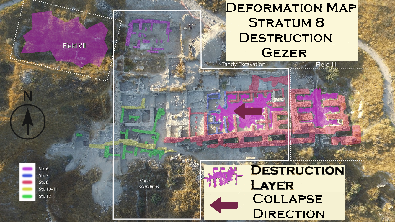
Webster et al. (2023: 12) report that Stratum 8 “seems to have suffered a major destructive event,” in which “most walls of the administrative building” collapsed in the same direction—westward. The structure “was buried in up to 1.5 m of mudbrick debris,” and “concentrations of boulders filled some rooms.” No human remains were found within the building. Webster et al. (2023: 12) further note that “HUC found evidence of destruction in the adjacent six-chambered gate, as well as in Field VII.” |
| Effect | Location | Image | Description |
|---|---|---|---|
|
the pillared unit
Gezer: plan of the mound, excavation fields, and principal remains. Stern et al (1993 v. 3)
Fig 3Aerial view of the Tandy excavations, with a wide exposure of iron age strata on the central-southern edge of the Gezer mound between fields VII and III of Hebrew Union College. Webster et al. (2023)
Fig 8Plan of Tandy excavation stratum 7 domestic units with radiocarbon dated contexts marked. Webster et al. (2023) |
Webster et al. (2023: 13) report that Stratum 7 “came to a sudden end, as evidenced by a destruction layer in the pillared unit that included a large assemblage of Iron IIA restorable vessels.” Although no specific date or cause was provided, they note that “the destruction was initially thought to date to the second part of the 9th century BC, associated with the campaign of the Aramaean ruler Hazael ca. 830 BC, which destroyed the nearby city of Gath ( 2 Kings 12:18) and possibly other sites.” According to 2 Kings 12:18, “At that time, King Hazael of Aram came up and attacked Gath and captured it; and Hazael proceeded to march on Jerusalem.” They further report that “ceramic parallels were initially drawn with Tell es-Safi (Gath) and Tel Zayit.” |
| Effect | Location | Image | Description |
|---|---|---|---|
| Collapsed Wall Fallen Ashlar Blocks in a debris layer |
Field XI - outer face outer wall at "Tower VII"
Plate 4 Plan of Tel Gezer Younker (1991)
Plate 19Detail of Field XI (after Macalister). Note approximate locations of Squares 21 and 22. Younker (1991) |
Plate 15a JW:
Younker (1991)
Plate 15b
Younker (1991) |
|
| Displaced Wall - Shifted Ashlar Blocks | Field XI - inner face of outer wall at "Tower VI"
Plate 4 Plan of Tel Gezer Younker (1991)
Plate 19Detail of Field XI (after Macalister). Note approximate locations of Squares 21 and 22. Younker (1991) |
Plate 16a JW: Are displaced ashlars at the bottom ? Younker (1991)
Plate 16b
Younker (1991) |
|
| Penetrative fractures in masonry blocks - through going joints | Field XI - inner face of outer wall at "Tower VI"
Plate 4 Plan of Tel Gezer Younker (1991)
Plate 19Detail of Field XI (after Macalister). Note approximate locations of Squares 21 and 22. Younker (1991) |
Plate 16a JW: through going joints Younker (1991)
Plate 16b
Younker (1991) |
|
| Tilted Walls | Field XI - inner face of outer wall at "Tower VI"
Plate 4 Plan of Tel Gezer Younker (1991)
Plate 19Detail of Field XI (after Macalister). Note approximate locations of Squares 21 and 22. Younker (1991) |
Plate 16a JW: through going joints Younker (1991)
Plate 16b
Younker (1991) |
|
| Tilted, displaced, and folded walls | Field XI - East of "Tower VI" in Areas 20 and 21
Plate 4 Plan of Tel Gezer Younker (1991)
Plate 19Detail of Field XI (after Macalister). Note approximate locations of Squares 21 and 22. Younker (1991)
Figure 13General Plan of Field XI East showing 1990 excavation areas; note line of Sections β-β', γ—γ' (cf. fig. 14). Dever (1993) |
Figure 15 Line of Outer Wall between Field XI, Areas 20 and 21, looking west. Note wall stones still in alignment, but displaced northward, downslope, cf. fig. 14. Dever (1993)
Figure 2Tel Gezer, Field XI, Area 20: 'Outer Wall' (view to the north-west). Note the wall stones displaced and tilted outward, downslope. Dever and Younker (1991) |
|
| Tilted Walls | Field XI - Areas 21 and 22
Plate 4 Plan of Tel Gezer Younker (1991)
Plate 19Detail of Field XI (after Macalister). Note approximate locations of Squares 21 and 22. Younker (1991)
Figure 13General Plan of Field XI East showing 1990 excavation areas; note line of Sections β-β', γ—γ' (cf. fig. 14). Dever (1993) |
Figure 16 Schematic rendering of Section γ—γ' through Outer Wall in Field XI, Areas 21 and 22; cf. fig. 13. Dever (1993)
Figure 17Field XI, Area 22, looking south, with Section α—α' to right. Below meter stick is LB II Wall 22,002, founded on bedrock; above is Iron Age Wall 22,000, partially plastered. Note differing masonry, offset alignment; cf. fig. 16 for Section γ—γ'. Dever (1993) |
|
| Effect | Location | Image | Description |
|---|---|---|---|
|
the pillared unit
Gezer: plan of the mound, excavation fields, and principal remains. Stern et al (1993 v. 3)
Fig 3Aerial view of the Tandy excavations, with a wide exposure of iron age strata on the central-southern edge of the Gezer mound between fields VII and III of Hebrew Union College. Webster et al. (2023) |
Webster et al. (2023: 13) report that the Stratum 6 domestic buildings in the northwestern part of the Tandy excavation “came to a sudden end, as evidenced by a destruction layer in the pillared unit that included a large assemblage of Iron IIA restorable vessels.” They attribute this destruction to the Assyrian conquests of Tiglath-Pileser III around 734-732 BCE. |
- Modified by JW from Figure 4 of Webster et al. (2023)
 Deformation Map
Click on image to open in a new tab
Modified by JW from Figure 4 of Webster et al. (2023)
- Modified by JW from Map of the Gezer Mound of Stern et al (1993 v. 2)
 Deformation Map
Click on image to open in a new tab
Modified by JW from Map of the Gezer Mound of Stern et al (1993 v. 2)
- Modified by JW from Figure 3 of Webster et al. (2023)
 Deformation Map
Click on image to open in a new tab
Modified by JW from Figure 3 of Webster et al. (2023)
- Modified by JW from Plate 19 of Younker (1991)
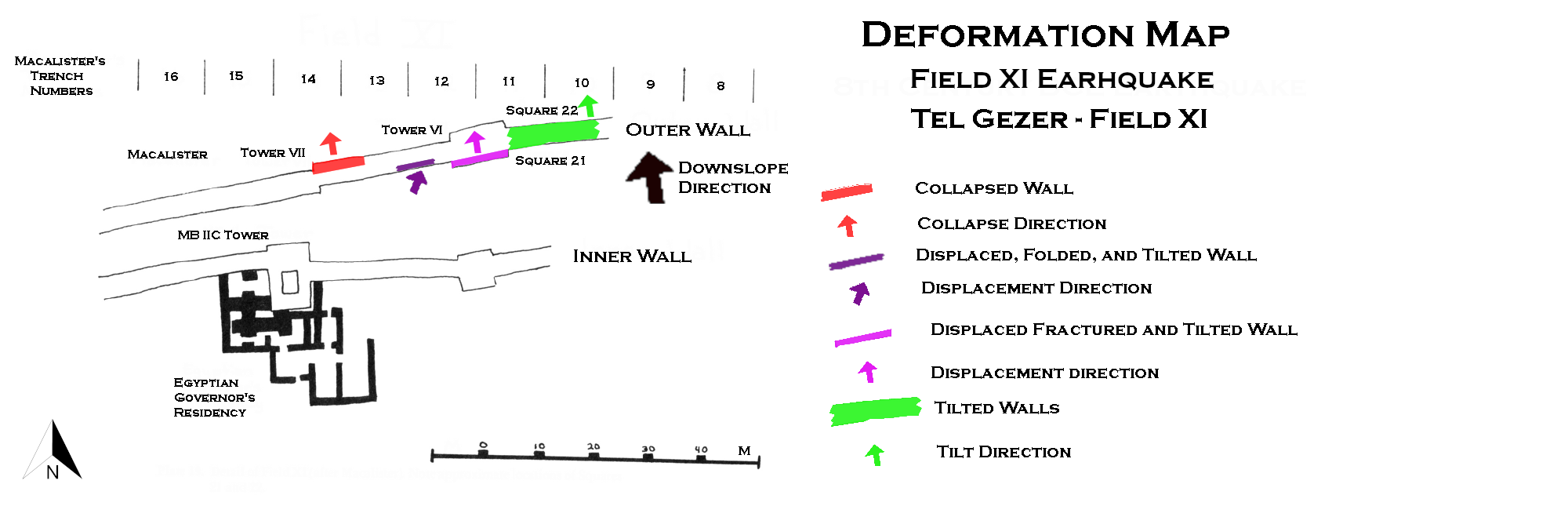 Deformation Map
Click on image to open in a new tab
Modified by JW from Plate 19 of Younker (1991)
- Earthquake Archeological Effects chart
of Rodríguez-Pascua et al (2013: 221-224)
 Earthquake Archeological Effects (EAE)
Rodríguez-Pascua et al (2013: 221-224)
| Effect | Location | Image | Description | Intensity |
|---|---|---|---|---|
|
Southern Gate Area
Gezer: plan of the mound, excavation fields, and principal remains. Stern et al (1993 v. 3)
Fig 3Aerial view of the Tandy excavations, with a wide exposure of iron age strata on the central-southern edge of the Gezer mound between fields VII and III of Hebrew Union College. Webster et al. (2023) |
Fig 4 Plan of Tandy excavation stratum 12B elite residence with radiocarbon dated contexts marked. The insert shows Individual #3. Webster et al. (2023) |
Webster et al. (2023: 9) describe the Stratum 12 B Building in the southern gate area as having been “destroyed in a fiery conflagration, whose calamitous nature is evidenced by the remains of three individuals.” The victims included a badly burned adult and child discovered in Room A, and “an adult female evidently killed by the collapsing building,” found in the southwest corner of Unit D. Burnt destruction debris and restorable pottery were identified in multiple rooms. |
|
- Earthquake Archeological Effects chart
of Rodríguez-Pascua et al (2013: 221-224)
Earthquake Archeological Effects (EAE)
Rodríguez-Pascua et al (2013: 221-224)
| Effect | Location | Image | Description | Intensity |
|---|---|---|---|---|
|
Southern Gate Area plus Fields II, VI, VII
Gezer: plan of the mound, excavation fields, and principal remains. Stern et al (1993 v. 3)
Fig 3Aerial view of the Tandy excavations, with a wide exposure of iron age strata on the central-southern edge of the Gezer mound between fields VII and III of Hebrew Union College. Webster et al. (2023)
Fig 6Plan of Tandy excavation strata 10A and 9 with radiocarbon dated contexts marked. Webster et al. (2023) |
Webster et al. (2023: 10) report that Stratum 10A structures in the south gate area were "violently destroyed, with evidence found in almost all rooms”. Analogous destruction layers may also have been found “in Fields II (local Str. 7A), VI (local Str. 4) and VII (local Str. 8).” Webster et al. (2023: 10) further note that “HUC identified multiple Iron I destruction horizons only in Field VI, in Granary 24000 (local Str. 6) and the courtyard houses of local Stratum 5.” Webster et al. (2023: 11) suggest that this destruction layer may have resulted from military conquest by Siamun or another 21st Dynasty ruler, based on 1 Kings 9:16, which states that “Pharaoh king of Egypt had come up and captured Gezer; he destroyed it by fire, killed the Canaanites who dwelt in the town, and gave it as dowry to his daughter, Solomon’s wife.” |
|
- Earthquake Archeological Effects chart
of Rodríguez-Pascua et al (2013: 221-224)
Earthquake Archeological Effects (EAE)
Rodríguez-Pascua et al (2013: 221-224)
| Effect | Location | Image | Description | Intensity |
|---|---|---|---|---|
|
Administrative Building, adjacent six-chambered gate, and Field VII
Gezer: plan of the mound, excavation fields, and principal remains. Stern et al (1993 v. 3)
Fig 3Aerial view of the Tandy excavations, with a wide exposure of iron age strata on the central-southern edge of the Gezer mound between fields VII and III of Hebrew Union College. Webster et al. (2023)
Fig 7Plan of Tandy excavation stratum 8 with radiocarbon dated contexts in the courtyard-type administrative building marked. Webster et al. (2023) |
Webster et al. (2023: 12) report that Stratum 8 “seems to have suffered a major destructive event,” in which “most walls of the administrative building” collapsed in the same direction—westward. The structure “was buried in up to 1.5 m of mudbrick debris,” and “concentrations of boulders filled some rooms.” No human remains were found within the building. Webster et al. (2023: 12) further note that “HUC found evidence of destruction in the adjacent six-chambered gate, as well as in Field VII.” |
|
- Earthquake Archeological Effects chart
of Rodríguez-Pascua et al (2013: 221-224)
Earthquake Archeological Effects (EAE)
Rodríguez-Pascua et al (2013: 221-224)
| Effect | Location | Image | Description | Intensity |
|---|---|---|---|---|
|
the pillared unit
Gezer: plan of the mound, excavation fields, and principal remains. Stern et al (1993 v. 3)
Fig 3Aerial view of the Tandy excavations, with a wide exposure of iron age strata on the central-southern edge of the Gezer mound between fields VII and III of Hebrew Union College. Webster et al. (2023)
Fig 8Plan of Tandy excavation stratum 7 domestic units with radiocarbon dated contexts marked. Webster et al. (2023) |
Webster et al. (2023: 13) report that Stratum 7 “came to a sudden end, as evidenced by a destruction layer in the pillared unit that included a large assemblage of Iron IIA restorable vessels.” Although no specific date or cause was provided, they note that “the destruction was initially thought to date to the second part of the 9th century BC, associated with the campaign of the Aramaean ruler Hazael ca. 830 BC, which destroyed the nearby city of Gath ( 2 Kings 12:18) and possibly other sites.” According to 2 Kings 12:18, “At that time, King Hazael of Aram came up and attacked Gath and captured it; and Hazael proceeded to march on Jerusalem.” They further report that “ceramic parallels were initially drawn with Tell es-Safi (Gath) and Tel Zayit.” |
|
- Earthquake Archeological Effects chart
of Rodríguez-Pascua et al (2013: 221-224)
Earthquake Archeological Effects (EAE)
Rodríguez-Pascua et al (2013: 221-224)
| Effect | Location | Image | Description | Intensity |
|---|---|---|---|---|
| Collapsed Wall Fallen Ashlar Blocks in a debris layer |
Field XI - outer face outer wall at "Tower VII"
Plate 4 Plan of Tel Gezer Younker (1991)
Plate 19Detail of Field XI (after Macalister). Note approximate locations of Squares 21 and 22. Younker (1991) |
Plate 15a JW:
Younker (1991)
Plate 15b
Younker (1991) |
|
VIII+ |
| Displaced Wall - Shifted Ashlar Blocks | Field XI - inner face of outer wall at "Tower VI"
Plate 4 Plan of Tel Gezer Younker (1991)
Plate 19Detail of Field XI (after Macalister). Note approximate locations of Squares 21 and 22. Younker (1991) |
Plate 16a JW: Are displaced ashlars at the bottom ? Younker (1991)
Plate 16b
Younker (1991) |
|
VII+ |
| Penetrative fractures in masonry blocks - through going joints | Field XI - inner face of outer wall at "Tower VI"
Plate 4 Plan of Tel Gezer Younker (1991)
Plate 19Detail of Field XI (after Macalister). Note approximate locations of Squares 21 and 22. Younker (1991) |
Plate 16a JW: through going joints Younker (1991)
Plate 16b
Younker (1991) |
|
VI+ |
| Tilted Walls | Field XI - inner face of outer wall at "Tower VI"
Plate 4 Plan of Tel Gezer Younker (1991)
Plate 19Detail of Field XI (after Macalister). Note approximate locations of Squares 21 and 22. Younker (1991) |
Plate 16a JW: through going joints Younker (1991)
Plate 16b
Younker (1991) |
|
VI+ |
| Tilted, displaced, and folded walls | Field XI - East of "Tower VI" in Areas 20 and 21
Plate 4 Plan of Tel Gezer Younker (1991)
Plate 19Detail of Field XI (after Macalister). Note approximate locations of Squares 21 and 22. Younker (1991)
Figure 13General Plan of Field XI East showing 1990 excavation areas; note line of Sections β-β', γ—γ' (cf. fig. 14). Dever (1993) |
Figure 15 Line of Outer Wall between Field XI, Areas 20 and 21, looking west. Note wall stones still in alignment, but displaced northward, downslope, cf. fig. 14. Dever (1993)
Figure 2Tel Gezer, Field XI, Area 20: 'Outer Wall' (view to the north-west). Note the wall stones displaced and tilted outward, downslope. Dever and Younker (1991) |
|
VII+ |
| Tilted Walls | Field XI - Areas 21 and 22
Plate 4 Plan of Tel Gezer Younker (1991)
Plate 19Detail of Field XI (after Macalister). Note approximate locations of Squares 21 and 22. Younker (1991)
Figure 13General Plan of Field XI East showing 1990 excavation areas; note line of Sections β-β', γ—γ' (cf. fig. 14). Dever (1993) |
Figure 16 Schematic rendering of Section γ—γ' through Outer Wall in Field XI, Areas 21 and 22; cf. fig. 13. Dever (1993)
Figure 17Field XI, Area 22, looking south, with Section α—α' to right. Below meter stick is LB II Wall 22,002, founded on bedrock; above is Iron Age Wall 22,000, partially plastered. Note differing masonry, offset alignment; cf. fig. 16 for Section γ—γ'. Dever (1993) |
|
VI+ |
- Earthquake Archeological Effects chart
of Rodríguez-Pascua et al (2013: 221-224)
Earthquake Archeological Effects (EAE)
Rodríguez-Pascua et al (2013: 221-224)
| Effect | Location | Image | Description | Intensity |
|---|---|---|---|---|
|
the pillared unit
Gezer: plan of the mound, excavation fields, and principal remains. Stern et al (1993 v. 3)
Fig 3Aerial view of the Tandy excavations, with a wide exposure of iron age strata on the central-southern edge of the Gezer mound between fields VII and III of Hebrew Union College. Webster et al. (2023) |
Webster et al. (2023: 13) report that the Stratum 6 domestic buildings in the northwestern part of the Tandy excavation “came to a sudden end, as evidenced by a destruction layer in the pillared unit that included a large assemblage of Iron IIA restorable vessels.” They attribute this destruction to the Assyrian conquests of Tiglath-Pileser III around 734-732 BCE. |
|