Nahal Darga
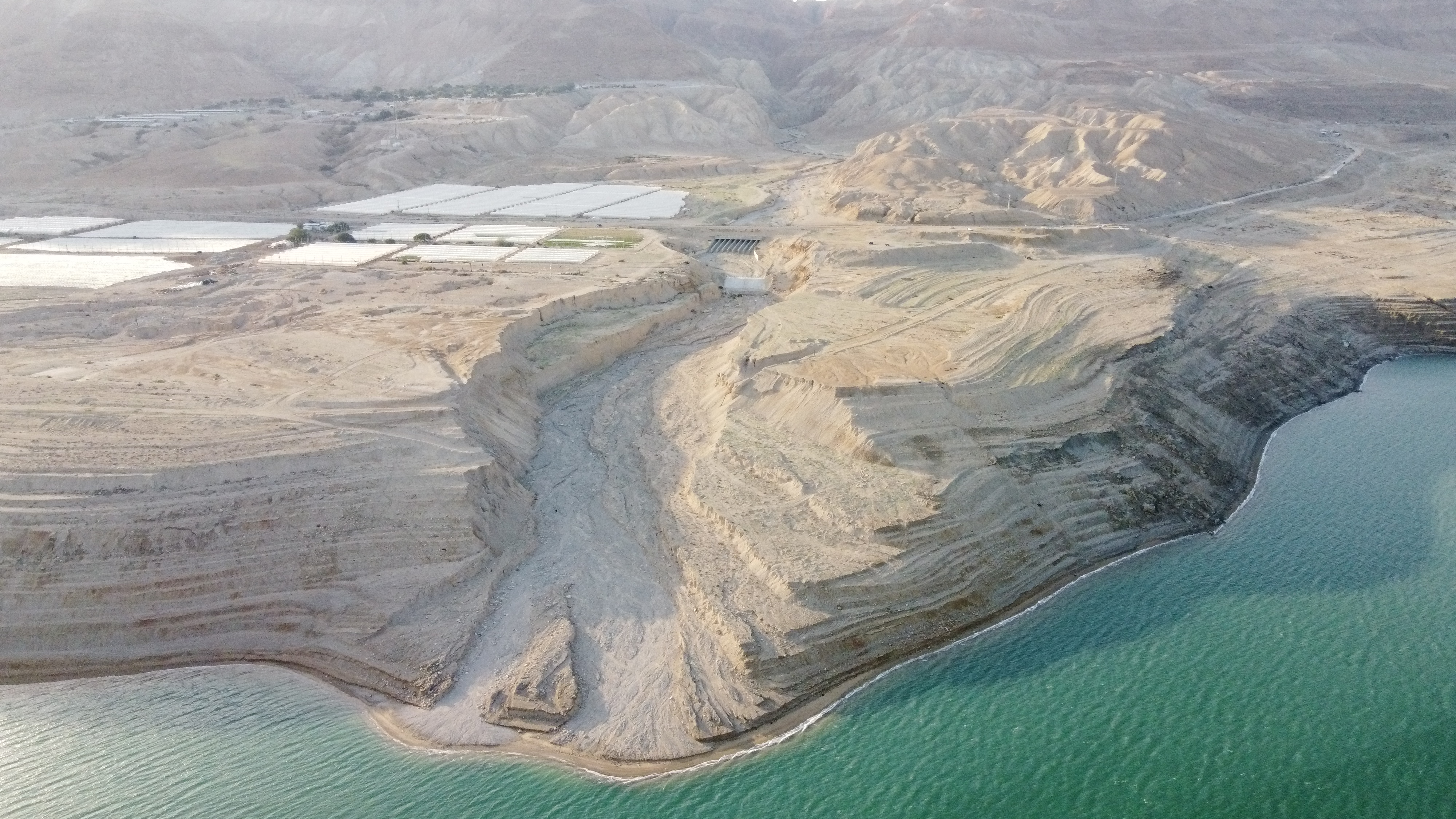 Aerial shot of Nahal Darga from the east
Click on Image to open a high resolution magnifiable image in a new tab
Photo by Jefferson Williams 10 Feb. 2023
- Fig. 1B Location Map from
Enzel et al (2000)
 Fig. 1B
A few active faults in the Dead Sea Area (Garfunkel et al., 1981; ten Brink and Ben-Avraham, 1989; Garfunkel and Ben-Avraham, 1996) and the epicenter of the Jericho 1927 earthquake (M 6.2) and its uncertainty ellipse (Shapira et al., 1993).
Enzel et al (2000) - Fig. 1D Site Map from
Enzel et al (2000)
 Fig. 1D
Shorelines of the Dead Sea on late Holocene fan-delta surfaces of Nahal Darga.
Enzel et al (2000) - Aerial Photo of Nahal Darga
by JW
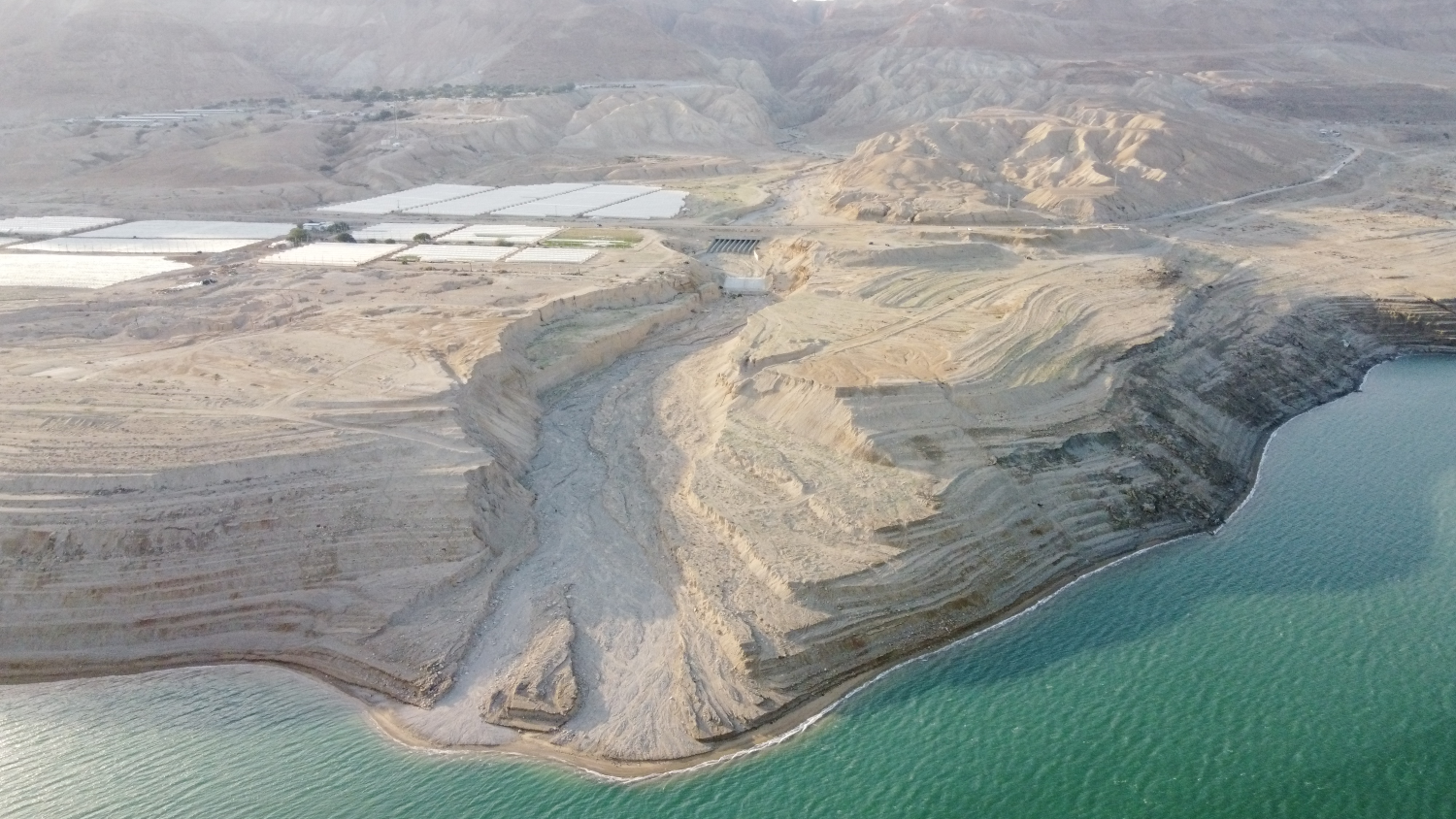 Aerial shot of Nahal Daraga from the east
Click on Image to open a high resolution magnifiable image in a new tab
Photo by Jefferson Williams 10 Feb. 2023 - Nahal Darga in Google Earth
 Nahal Darga
click on image to explore this site on a new tab in Google Earth - Nahal Darga on govmap.gov.il
 Nahal Darga
click on image to explore this site on a new tab in govmap.gov.il
Fig. 1DShorelines of the Dead Sea on late Holocene fan-delta surfaces of Nahal Darga.
Enzel et al (2000)

The stratigraphy of the southern wall (A) of the incised channel (Fig. 1) of Nahal Darga. No vertical exaggeration. The scale at the base of each section is in meters. The left end of each of the five sections is connected to the right end of the section below. Numbers in circles are easily identified field stratigraphic units; each may contain a few to many beds and more than one lithological characteristic. The main lithology is marked. See Table 1 for details of 14C ages.
Legend
- fluvial gravel
- near-shore sand with frequent ripple marks
- well-bedded to laminated clay silt with ocassional aragonite
- well- to medium sorted coarse sand, pebbles and cobbles in sets of the delta front
- well-sorted prograding beach deposits with lenses of clay–silt lagoonal deposits
- the major unconformity in the section; its age is estimated at approximately 4000 yr B.P. (Kadan, 1997)
These maps were produced by logging the walls at specific sites and by mapping with scaled photographs between them
Enzel et al (2000)

The stratigraphy of the northern wall (B) of the incised channel (Fig. 1) of Nahal Darga. No vertical exaggeration. The scale at the base of each section is in meters. The left end of each of the five sections is connected to the right end of the section below. Numbers in circles are easily identified field stratigraphic units; each may contain a few to many beds and more than one lithological characteristic. The main lithology is marked. See Table 1 for details of 14C ages.
Legend
- fluvial gravel
- near-shore sand with frequent ripple marks
- well-bedded to laminated clay silt with ocassional aragonite
- well- to medium sorted coarse sand, pebbles and cobbles in sets of the delta front
- well-sorted prograding beach deposits with lenses of clay–silt lagoonal deposits
- the major unconformity in the section; its age is estimated at approximately 4000 yr B.P. (Kadan, 1997)
These maps were produced by logging the walls at specific sites and by mapping with scaled photographs between them
Enzel et al (2000)
 Fig. 7
Example of a tectonic slump (Fig. 2A, meters 280–290).
Enzel et al (2000)

Detailed map of the western faulted zone at the southern wall of Nahal Darga (Figs. 2A and 3). The faults show a maximum of three displacements. For example the total vertical displacement of unit 4 on faults D–F is approximately 4.5 m. When the displacement is measured from the two ends of the figure and thickness changes are accounted for the total displacement is 3.5 m. The prograding beach deposits are displaced approximately 3.5 m by faults D–F but with lower total displacement in the entire zone. The units underneath the erosional unconformity (dark solid line) are .7000 yr B.P. Most of these units grade into sand a few tens of meters to the east. The age of the erosional channel and its associated deposits directly above the unconformity is not clear. The age of the unconformity itself is probably 4000 yr B.P. (Kadan, 1997). The top gravel unit is a historical alluvial-fan, which was active between 1900s and the late 1960s. Only minor fractures without any observed displacement cross the unconformity; none reach the surface.
Enzel et al (2000)
 Fig. 3
A photograph showing faults A and B of Figure 4 exposed at the southern wall (see Fig. 2A, meters 80–115). Such excellent exposures exist all along the wall of the incised Nahal Darga as it flows from right to left. See Figure 4 for scale and explanations. Note the tilted beds with well-pronounced prograding beach ridge deposits in the middle of the section. The erosional channel parallels the faults and was filled with coarse sandy gravel of unknown age and was truncated and covered by a very thin cap (;0.5 m) by 1960s alluvial-fan deposits.
Enzel et al (2000)
 Fig. 6A
Ball and pillow structures from deformation 10 (Table 2) that occurred 400–500 yr B.P.
Enzel et al (2000)
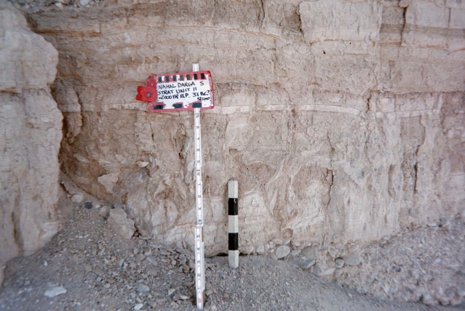 Fig. 6B
Deformation 9 in Stratigraphic Unit 11 which occurred 2000 yr B.P. likely due to the Josephus Quake of 31 BCE.
Photo by Jefferson Williams in May 2000
 Fig. 5D
Deformation 5 (Table 2) at approximately 10 m to the west is changing its characteristics. The deformations in this bed have a large variety of forms.
The comparison between 5C and 5D indicates that the gravel in D was deposited much later than the deformation.
Enzel et al (2000)
 Fig. 5C
Deformations 4 (lower) and 5 (upper, with the scale) (Table 2) are separated by a thin undeformed bed. The stratigraphy at left of the photograph indicates that deposition prior to the second deformation was thicker than this thin undeformed bed.
The comparison between 5C and 5D indicates that the gravel in D was deposited much later than the deformation.
Enzel et al (2000)
 >Fig. 6B
Dike-like structure of the underlying layer penetrating the overlying deformed bed (deformation 3, Table 2)
Enzel et al (2000)
 Fig. 5B
Example of part of deformation 3 (Table 2).
Enzel et al (2000)
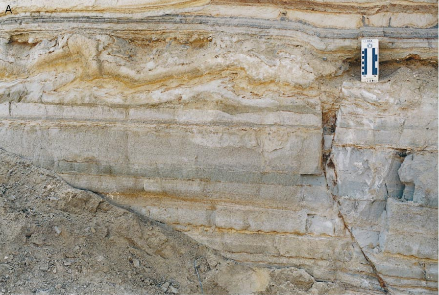 Fig. 5A
The only fault-related deformation (Table 2, deformation 2). Convoluted laminations next to the minor fault that was active approximately 8000 yr B.P. Load cast are seen a few meters laterally.
Enzel et al (2000)
 Fig. 1C
Dip directions of the measured faults exposed in the Holocene sequence of the fan-delta of Nahal Darga.
Enzel et al (2000)
 Orthophoto of Nahal Darga
Click on Image for high resolution magnifiable image
Drone photos by Jefferson Williams 10 Feb. 2023
- from Enzel et al. (2000)
 Table 1
Results of Radiocarbon Age Dating
Click on Image for high resolution magnifiable image
Enzel et al. (2020)
The stratigraphy of the northern wall (B) of the incised channel (Fig. 1) of Nahal Darga. No vertical exaggeration. The scale at the base of each section is in meters. The left end of each of the five sections is connected to the right end of the section below. Numbers in circles are easily identified field stratigraphic units; each may contain a few to many beds and more than one lithological characteristic. The main lithology is marked. See Table 1 for details of 14C ages.
Legend
- fluvial gravel
- near-shore sand with frequent ripple marks
- well-bedded to laminated clay silt with ocassional aragonite
- well- to medium sorted coarse sand, pebbles and cobbles in sets of the delta front
- well-sorted prograding beach deposits with lenses of clay–silt lagoonal deposits
- the major unconformity in the section; its age is estimated at approximately 4000 yr B.P. (Kadan, 1997)
These maps were produced by logging the walls at specific sites and by mapping with scaled photographs between them
Enzel et al (2000)
Most faults within the study area are associated with the two deformation zones; only a few occur outside the zones (Fig. 2B). The faults are normal, and striations on some of the fault planes suggest dip–slip displacements; on a few faults, a small component of left-lateral slip was observed. Dips of the faults cluster in two main trends, ESE and WNW (Fig. 1C). The faults from the respective deformation zones differ mainly in vertical displacement, in our ability to identify a specific fault in both walls, and in evidence for multiple displacements.
The normal faults in the western zone (Figs. 2–4) reveal multiple events that intersect almost the entire exposed section. Vertical components of displacement along these faults range from a few centimeters to 2 m. Examination of individual faults and beds in Fig. 4 indicates progressively larger offsets of older units, which in turn indicate multiple displacement events. Along some faults, three discrete displacements were observed, whereas along other faults only one or two events were identified (Fig. 4). It is difficult to determine which of the displacements on one fault affected nearby faults.
The youngest deformation we can detect is revealed in the northern wall. Between meters 15 and 30 (Fig. 2B), faults reach the surface. The age of the last activity on these faults is <2225 ± 50 yr B.P., which is the age of the youngest deposit stratigraphically beneath the youngest faulted units (Fig. 2B, meter 250 and follow units into meter 30). This age of faulting is supported by the youngest possible age of the faulted beach gravel that underlies the surface at the fault line; the last time a lake level reached 370 m below sea level to deposit such gravel was 3000–4000 yr ago (Kadan, 1997). The timing of the earlier displacements observed on these faults is estimated at 9500–7000 yr B.P. from the radiocarbon dates (Table 1, Fig. 2).
The faults in the eastern deformation zone (meters 255–320, Fig. 2B) are confined to three layers and most clearly appear in a sandy layer bearing ripple marks. The vertical displacements along these faults are small and do not exceed 10 cm; no evidence for multiple movements was identified. The age of this faulting, according to dated displaced strata, is younger than 2400 yr B.P. No field evidence directly connects these minor faults with other tectonic structures. However, they are spatially associated with the allochthonous tectonic slumps discussed below.
To examine the possibility that the exposed faults are expressions of shallow gravitational movement, we recently acquired four high-resolution seismic profiles (Kadan, 1997; Eyal et al., 1997). These profiles demonstrate that large deep-seated subsurface faults exist below the two narrow deformation zones.