Go to top

11th century CE Palestine Quakes

6 December 1033 CE and ~17 or 18 February 1034 CE

by Jefferson Williams


Introduction & Summary

Just before sunset on Thursday 6 December 1033 CE1, a powerful earthquake struck Palestine. Strong aftershocks are reported to have continued for the next ~24-36 hours. The precise date and time comes from an eye-witness account found in a letter in the Cairo Geniza. The witness experienced the earthquake in Ramla where many structures failed and many residents died. A second earthquake may have struck around 17 or 18 February 1034 CE - dates reported by the contemporary author George Cedrenus and later writing author John Scylitzes. Jerusalem was damaged where many structures are reported to have collapsed and the Al Aqsa mosque was destroyed and had to be rebuilt. Other locations mentioned as receiving damage included Hebron, Jericho, Ascalon, Gaza, the Negev, Nablus and the surrounding area, Tiberias and the surrounding area, the district of Banias, Syria, Palestine, and Akko where a tsunami is also reported. Over a dozen Hebrew, Greek, Persian, Arabic, and Syriac writing authors have provided a rich corpus of seismic effects complemented by an array of archaeoseismic and paleoseismic evidence.
Footnotes

1 Although this earthquake is widely dated to 5 December 1033 CE, Calendaric and Julian Day calculations reveal that it struck on 6 December 1033 CE. See the Chronology section in A letter written by Salomon ben Zemah.

Textual Evidence

<
Text (with hotlink) Original Language Biographical Info Religion Date of Composition Location Composed Notes
Damage and Chronology Reports from Textual Sources n/a n/a n/a n/a n/a n/a
Salomon ben Zemah Hebrew
Biography

Jewish 1033 CE Ramla eye-witness account which describes a seismic shock in Ramla just before sunset on 6 December 1033 CE, shocks continuing through the night, and recurring shocks the next evening. Lists numerous Seismic Effects and locations which experienced damage.
Nasir-i Khusrau Persian
Biography

Isma'ili Shi'ite Muslim 11th century CE - covers travels undertaken from 6 March 1046 – 23 October 1052 CE Yamagan (Afghanistan) ? Nasir i-Khusrau described an inscription over one of the porches of the Mosque in Ramla which stated that on Muharram 15, of the year 425 (December 10, 1033), there was an earthquake of great violence, which threw down a large number of buildings, but that no single person sustained any injury.
Cedrenus Greek
Biography

Orthodox (Byzantium) 1050s CE Anatolia States that an earthquake damaged the cities of Syria on 18 Feb. 1034 CE. This date may represent a report of an aftershock.
Michael the Bishop of Tannis Arabic or Coptic translated to Arabic (Claremont Coptic Encyclopedia)
Biography

Coptic Christian 1051 or 1058 CE (Claremont Coptic Encyclopedia) Tinnis, Egypt describes two mountains in the district of Paneas [which] met together and fire came out from between them and describes an unlocated tsunami. The date of these events is constrained to 13 December 1032 - 13 June 1036 CE.
Yahya of Antioch Arabic
Biography

Melkite Christian 11th century CE AntiochReports that a terrible earthquake struck the area, such as had never been seen or heard of before. He lists a number of seismic effects, half the houses in Ramla collapsed, cities effected, and describes a tsunami in Akko. Yahya of Antioch appears to have listed the wrong month. If one substitutes the month prior (Muharram) for the month supplied by Yahya (Safar), one comes up with a date of 5 December 1033 CE.
Unpublished Greek Manuscript Greek
Biography

Christian describes an earthquake in A.H. 425 on the first day of the week of Asotus. States that the shocks lasted for 2 days. Describes a number of seismic effects and mentions a number of localities damaged.
Scylitzes Greek
Biography

Christian late 11th century Constantinople ? States that on the seventeenth of February, there was an earthquake and the cities of Syria suffered severely. The 17 February date is close to the 18 February date supplied by Cedrenus. The year supplied by Scylitzes (1039 or 1055 CE) is way off compared to the other textual accounts.
Benjamin of Tudela Hebrew
Biography

Jewish 12th century CE transcibed a manuscript from Ramla which described the earthquake which struck at sunset on 6 December 1033 CE. Lists numerous Seismic Effects and locations which experienced damage.
Michael Glycas Greek
Biography

Christian 2nd half of the 12th century CE Constantinople States that Jerusalem was afflicted by an earthquake, such that in the ruins of Temples and Houses, a large number of people were crushed and the earth shook for forty days.
Ibn al-Jawzi Arabic
Biography

Hanbali Sunni Muslim 2nd half of the 12th c. CE Baghdad Reports an earthquake in Ramla in the year A.H. 425 (26 November 1033 to 15 November 1034 CE). Lists numerous seismic effects and other localities affected.
Ibn al-Athir Arabic
Biography

Muslim 1231 CE Mosul Reports a very violent earthquake [which] ravaged Syria and Egypt, focused most strongly on Ramla in the year A.H. 425 (26 November 1033 to 15 November 1034 CE).
Bar Hebraeus Syriac
Biography

Syriac Orthodox Church 13th century CE possibly Maraghah Bar Hebraeus reports an earthquake in Egypt and Palestine between 26 November 1033 and 30 Sept. 1034 CE. He lists a number of seismic effects, cities effected, and describes a tsunami in Akko.
al-Dhahabi Arabic
Biography

Muslim Early 14th century CE Damascus Ambraseys (2009) noted that Great History of Islam by al-Dhahabi contains a passage about this earthquake.
Muhammad Ibn Shakir al-Kutubi Arabic
Biography

14th century CE Damascus Ambraseys (2009) and Guidoboni and Comastri (2005) both indicate that al-Kutubi wrote about this earthquake.
as-Suyuti Arabic
Biography

Sufi Muslim 15th c. CE Cairo States that there were numerous earthquakes in Egypt and the Syrian territories in A.H. 425 (26 November 1033 to 15 November 1034 CE). The use of the plural earthquakes suggests that the many seismic effects mentioned and localities named may represent an amalgamation from more than one earthquake.
Mujir al-Din Arabic
Biography

Muslim ca. 1495 CE Jerusalem Ambraseys (2009) and Guidoboni and Comastri (2005) both indicate that Mujir al-Din wrote about this earthquake.
Restoration Work done on Al Aqsa Mosque in A.H. 426 Le Strange (1890:101-102) presents evidence that Al Aqsa Mosque was restored soon after the damaging earthquake.
Other Authors
Text (with hotlink) Original Language Biographical Info Religion Date of Composition Location Composed Notes
Damage and Chronology Reports from Textual Sources

Seismic Effects

Seismic Effects
Location Description Sources Comments
Earthquake lasted two days Salomon ben Semah, Unpublished Greek Manuscript
Aftershocks Salomon ben Semah, Unpublished Greek Manuscript, Glycas
Unlocated Mountains shaking Salomon ben Semah, Michael the Bishop of Tannis, Benjamin of Tudela Michael the Bishop of Tannis states two mountains in the district of Paneas met together and fire came out from between them.
Unlocated Rocks exploded Salomon ben Semah, Benjamin of Tudela
Unlocated Bent Trees Salomon ben Semah, Benjamin of Tudela
Unlocated Sloshing water in cisterns and wells Salomon ben Semah, Benjamin of Tudela
Syria damaged cities Cedrenus, Skylitzes, Bar Hebraeus, Benjamin of Tudela
Jerusalem Building collapses Yahya of Antioch, Glycas, Bar Hebraeus, Ibn al-Jawzi
Jerusalem prayer niche (mihrab) of David and/or Synagogue of David Damaged Ibn al-Jawzi, as-Suyuti
Jerusalem Partial Collapse of City Walls al-Jawzi, as-Suyuti
Al Aqsa Mosque in Jerusalem partial collapse Yahya of Antioch, Unpublished Greek Manuscript, al-Jawzi, Bar Hebraeus, Restoration Work mentioned by Le Strange (1890:101-102) Unpublished Greek Manuscript states that part of the Dome in Jerusalem fell. This appears to refer to Al Aqsa rather than the Dome of the Rock. Ibn al-Jawzi states that the Dome of the Rock was not damaged
Hebron Partial Destruction of Mosque of Abraham Ibn al-Jawzi, as-Suyuti
Jericho swallowed up Yahya of Antioch, Unpublished Greek Manuscript
Ramla Building Collapses Salomon ben Semah, Nasir i-Khusrau, Yahya of Antioch, Unpublished Greek Manuscript, Benjamin of Tudela, Ibn al-Athir, Ibn al-Jawzi, as-Suyuti Various authors specified collapse of the walls, the mosque, and many houses.
Ascalon Minaret fell down Bar Hebraeus, Ibn al-Jawzi, as-Suyuti
Gaza Top of a Minaret fell down Bar Hebraeus, Ibn al-Jawzi, as-Suyuti Ibn al-Jawzi may indicate that the whole minaret fell down. Others indicate that only the top broke off.
Nablus and nearby villages swallowed up Yahya of Antioch, Unpublished Greek Manuscript, Ibn al-Jawzi, as-Suyuti
al-Badan swallowed up as-Suyuti there is uncertainty as to where this place is located
Balash half the city collapsed Bar Hebraeus there is uncertainty as to where this place is located
Akko houses collapsed Yahya of Antioch, Unpublished Greek Manuscript, Bar Hebraeus
Akko Tsunami Michael the Bishop of Tannis, Yahya of Antioch, Unpublished Greek Manuscript, Bar Hebraeus

Locations

Locations
Location Sources Comments
Syria Cedrenus, Skylitzes, Bar Hebraeus, Benjamin of Tudela, Ibn al-Athir
Palestine Salomon ben Semah, Benjamin of Tudela
Negev Salomon ben Semah
Jerusalem Salomon ben Semah, Yahya of Antioch, Unpublished Greek Manuscript, Benjamin of Tudela, Glycas, Bar Hebraeus, Ibn al-Jawzi, as-Suyuti, Restoration Work mentioned by Le Strange (1890:101-102)
Hebron Ibn al-Jawzi, as-Suyuti
Jericho Yahya of Antioch, Unpublished Greek Manuscript
Ramla Salomon ben Semah, Nasir i-Khusrau, Yahya of Antioch, Unpublished Greek Manuscript, Benjamin of Tudela, Ibn al-Athir, Ibn al-Jawzi, as-Suyuti
Ascalon Bar Hebraeus, Ibn al-Jawzi, as-Suyuti
Gaza Bar Hebraeus, Ibn al-Jawzi, as-Suyuti
Nablus and nearby villages Salomon ben Semah, Yahya of Antioch, Unpublished Greek Manuscript, Benjamin of Tudela, Ibn al-Jawzi, as-Suyuti
Tiberias and nearby villages Salomon ben Semah, Benjamin of Tudela
Galilean Mountains Salomon ben Semah
Balash Bar Hebraeus there is uncertainty as to where this place is located
al-Badan as-Suyuti there is uncertainty as to where this place is located
District of Paneas Michael the Bishop of Tannis, Benjamin of Tudela
Akko Michael the Bishop of Tannis, Yahya of Antioch, Unpublished Greek Manuscript, Bar Hebraeus

A letter written by Salomon ben Zemah

Background and Biography

Background and Biography

Excerpts
English from Guidoboni and Comastri (2005)

[...] they went out from their houses into the streets because they saw the walls bending and yet intact, and the beams become separated from the walls and then revert to their former position. Strong buildings collapsed and new houses were pulled down. Many died in the ruins, for they could not escape. All went out from their dwellings, leaving everything behind. Wherever they turned they beheld God's powerful deeds. Walls crashed together and collapsed. Those that remained were shaky and rent. Nobody resided within them, for their owners feared they might fall down on top of them even before daybreak. Even to describe a part of the happenings, the hand would weary. Also the mind is distraught from what the eye saw and the ear heard. The verse has been fulfilled, "Behold the Lord empties out the land and lays it waste, distorts its face and scatters its inhabitants". He that is prudent will understand. For all were alike, like people like priest, like servant like master, when they left their places and sought refuge to save their lives. Many resigned themselves to the (Divine) judgment, reciting several verses (from Jer. 10.10, Ps. 104. 32, Job 9.6, Amos 9.5, Hos. 4.3, Nah. 1.6). This event took place on Thursday, 12 Tevet, suddenly before sunset, affecting not only Ramla but the whole of Filastin, from fortified city to open village, all the fortresses of Egypt [i.e. subject to Fatimid rule] from the sea to Fort Dan [Baniyas], all the cities of the south (Negev) and from the Mount to Jerusalem (and its surroundings), to Shehem [Nablus] and its villages, Tiberias and its villages, the Galilean mountains and the whole of Palestine'. 'Those that travelled on the high roads relate the mighty acts of the living God. They say "We have seen the mountains shake, leap like stags, their stones broken into pieces, the hillocks swaying to and fro, and the trees bending down". In some places the waters in the cisterns reached the brim. The tongue is inadequate for the tale. Thanks to God's mercy it happened before the day was gone, when people could see and warn each other, for had it been in the night when everybody was asleep, only a few would have been saved. But His mercies are many and his kindnesses numerous. Though He passed judgment, He will not utterly destroy. He, moreover, in His goodness brought out thick clouds and heavy raindrops fell. Two great rainbows appeared. One of them split into two and fire was visible from the south west. Thereupon the earthquake took place, the like of which there had not been since early times. On that night (the earth) shook again. All were in the streets, men, women, and children, imploring God, the Lord of the spirits, to quieten the earth and set it at rest and save both man and animal. On Friday, as well as on the following night, the shocks recurred. All were terrified and fear stricken. Earth and its inhabitants were molten (in fear). They all wept and cried with a loud voice, 0 merciful One, have mercy and withdraw the intended punishment. Do not enter upon judgment. In anger remember to be merciful and pay no heed to (our) former sins. All are trembling, sitting on the ground, startled every moment, shaking and swaying to and fro. For eight days the mind has not been satisfied and the soul is not at rest.

What could the writer (of this letter) do (but) address the people to declare a fast, summon a solemn assembly, go out to the field, the cemetery, in fasting, weeping and lamentation, and recite "Tear your hearts, and not your garments, and return to the Lord your God, etc. Come, let us return to God, etc. And let us ask for mercy. Who knows, (perhaps) He will retract and repent, etc. Perhaps He will go back from His fierce anger, so that we perish not". (God) magnified the miracle in that for all the days which the people spent in the streets and in the open, no rain fell. Also, the governor of the city, with the men in the Caliph's employ, pitched tents for themselves outside the town, and are still there. May the Lord, the God of the universe, look down mercifully upon his world, have pity on (His) creatures, save man and animal, and have compassion on babes and sucklings and those who know not how (to distinguish) between right and wrong, so that we perish not. May He deliver you from this and the like, protect you from all harsh judgments, hide you in his tabernacle on the day of evil, and shelter you in the protection of His wings. May He exalt you and may your good acts, kindnesses, and righteous deeds stand you in good stead. May he make you dwell securely and safe from evil fear, and may you be at peace, your houses and all that belongs to you be at peace. Receive ye peace from the Lord of Peace". [trans. based on that in Mann, 1920].

Chronology
Year Reference Corrections Notes
6 December 1033 CE Main shock - before sunset Thursday, 12 Tevet AM 4794 none
  • Calculated using CHRONOS
  • 6 December 1033 CE falls on a Thursday (calculated using CHRONOS)
  • Gil (1992:399) noted that we learn from the letter the exact date of the earthquake, which was Thursday, 12 Tevet AM 4794, that is, 5 December AD 1033, and there was another on the morrow, Friday 6 December.
  • The dates from Gil (1992:399) differ by a day when using modern Hebrew calendar rules which (according to Stern, 2012:334-335) were in place by the early 10th century CE.
  • Chronological Results presented here come from Modern Hebrew Calendar rules
  • The coincidence of the day of the week (Thursday) with the date of 12 Tevet AM 4794 (= 6 December 1033 CE) indicates that Gil (1992:399) (and everybody else) made a miscalculation of one day and adds support that the letter from Salomon ben Semah of Ramla is chronologically reliable
night of 7 or early morning 8 December 1033 CE Recurring shocks - the following Friday night/Shabbat none
  • Incremented from 6 December 1033 CE
  • 6 December 1033 CE falls on a Thursday (calculated using CHRONOS)
  • 7 December 1033 CE falls on a Friday (calculated using CHRONOS)
  • 8 December 1033 CE falls on a Saturday (calculated using CHRONOS)
Seismic Effects Locations mentioned Online Versions and Further Reading
References

Book of Travels by Nasir-i Khusrau

Background and Biography

Background and Biography

Excerpts
English from Le Strange (1890)

The next account of Ramlah is from the Diary of Nasir-i- Khusrau, who visited the city in 1047. He writes :
Sunday, the day of the new moon of the month of Ramadan (March i), we came to Ramlah. From Cassarea to Ramlah is 8 leagues. Ramlah is a great city, with strong walls built of stone, mortared, of great height and thickness, with iron gates opening therein. From the town to the sea-coast is a distance of 3 leagues. The inhabitants get their water from the rainfall, and in each house is a tank for storing the same, in order that there may always be a supply. In the middle of the Friday Mosque, also, is a large tank ; and from it, when it is filled with water, anyone who wishes may take. The area of the mosque measures 200 paces by 300 paces. Over one of its porches is an inscription, stating that on Muharram 15, of the year 425 (December 10, 1033), there was an earthquake* of great violence, which threw down a large number of buildings, but that no single person sustained any injury. ... (N. Kh., 21.)

Footnotes

* This earthquake is mentioned by the Arab annalists, who stale that a third of Ramlah was thrown down, the mosque in particular being left a mere heap of ruins. See p. 101.

English from Le Strange (1890) - embedded


Chronology

Year Reference Corrections Notes
10 December 1033 CE 15 Muharram A.H. 425 none
  • Calculated using CHRONOS
  • 10 December 1033 CE fell on a Monday (calculated using CHRONOS)
  • Agrees with date supplied by Le Strange
Seismic Effects Locations mentioned Online Versions and Further Reading
References

Synopsis Historion by Cedrenus

Background and Biography

Background and Biography

Excerpts
English from Becker (1838)

In the year of the world 6542 on the 17th of February, an earthquake damaged the cities of Syria

Latin from Becker (1838)

Hoc ipso mundi 6542 anno , die decima septima Februarii , terrae motus Syriae urbes afflixit.

Greek from Becker (1838)

Τούτω τώ εφμβ ' έτει , εξ Φεβρουαρίου μηνός , σεισμού D γεγονότος κακώς έπαθον αι εν Συρία πόλεις.

Latin from Becker (1838) - embedded

Characterization by Ambraseys (2009)

Ambraseys (2009) states that Cedrenus wrote that in A.M.a 6542 the earth shook for 'forty days', Jerusalem suffering heavy damage to its churches and many casualties but I don't see this in the Latin translation in the Becker Edition.

Chronology
Year Reference Corrections Notes
17 February 1034 CE 17 February A.M.a 6542 none applied
  • Calculated using CHRONOS
  • This date may represent a report of an aftershock
Seismic Effects Locations Online Versions and Further Reading
References

Continuation of History of the Patriarchs of Alexandria by Michael the Bishop of Tannis

Background and Biography

Background and Biography

Excerpts
English

In these days, there was the King Az-Zahir 1'‘Izazi dini' Hah and his name was Abu'l-Hasan [A. D. 1021-1036] and the wazir at that time (was) ‘Ali ibn Ahmad al-Gargani, and the administrator in the Rif (was) ‘Ali ibn Hadid, and he was of great ill-repute. He filled the prisons with people, men and women, so that pregnant women brought forth in the prisons.

There appeared in those days, in the land of Palestine a wonder (which) was that two mountains in the district of Paneas1 met together and fire came out from between them at their meeting together, and many trees were burnt, and a large part of the sea dried up so that men took up fish from the land which was uncovered, and they found in it (the land) lead and iron and many things. Then the sea returned to what it was before2.
Footnotes

1 i.e. Caesarea Paneas or Caesarea Philippi.

2 Cf. E. A. Wallis Budge, The Chronography of Gregory Abu l'-Farag (Barhebraeus), London, 1932, vol. 1, p. 194.

Chronology

The earthquake account above is within the section for Pope Shenouda II of Alexandria who ruled held the Apostolic Throne from 13 December 1032 – 29 October 1046 CE. There is also some chronological information that can be derived from the two sentences preceding the discussion of the two mountains. This information restricts the date of the events described to 13 December 1032 - 13 June 1036 CE and is summarized in the table below.
Date Range Personage
13 December 1032 – 29 October 1046 CE Coptic Pope Shenouda II of Alexandria
13 February 1021 – 13 June 1036 CE Fatimid Caliph Al-Zahir li-i'zaz Din Allah known as Abu'l-Hasan
1027 CE - March 1045 CE Wazir ‘Ali ibn Ahmad al-Gargani
? administrator in the Rif ‘Ali ibn Hadid
Seismic Effects Locations Online Versions and Further Reading
References

Continuation of Eutychius’ Annals by Yahya of Antioch

Aliases

Aliases in Arabic
Yahya of Antioch
Yaḥya ibn Saʿīd al-Anṭākī يحيى بن سعيد الأنطاكي
al-Anṭākī
Background and Biography

Excerpts
English from Guidoboni and Comastri (2005)

In that same year, al-Zahir began rebuilding the walls of Jerusalem the Noble, after rebuilding those of Ramla. Those who were entrusted with this work demolished many churches outside the city and took their stone. They were preparing to destroy the church of Sahyun (Sion), as well as other churches, so that they could take away the stone for the walls, when a terrible earthquake struck the area, such as had never been seen or heard of before, late on Thursday 10 Safar in the year 425 [H. = 4 January 1034]. Half the houses in Ramla collapsed, as well as various parts of the walls. There were many victims. Riha (Jericho) and its inhabitants were swallowed up, and the same thing happened at Nablus and nearby villages. Part of the great mosque of Jerusalem collapsed, as well as convents and churches in its province. Houses collapsed at Acre as well. There were a great many victims. The sea water receded from the port for an hour, and then returned to its place

English from Ambraseys (2009)

The caliph az-Zahir undertook in that year to build the walls of the noble city Jerusalem, after fortifying ar-Ramla. The builders began to destroy numerous churches outside the city. According to the requirements of the works, they removed the stones for building the walls. Then a prodigious earthquake occurred, the like of which had not been seen or talked of before, in the late morning of Thursday 10 Safar. Among the damaged [structures] were many ruined walls, and the victims reached considerable figure. The town of Arriha collapsed on its inhabitants, together with Nablus and neighbouring villages. Part of the mosque of Jerusalem collapsed together with numerous houses and churches in the surrounding area. And at Acre, too, houses collapsed on their inhabitants and there was a great number of victims. The sea drew back then returned as a tidal wave.' (al-Antaki ii. 272).

Chronology
Year Reference Corrections Notes
4 January 1034 CE late on Thursday 10 Safar in A.H. 425 none
  • Calculated using CHRONOS
  • 4 January 1034 CE falls on a Friday (calculated using CHRONOS).
5 December 1033 CE late on Thursday 10 Safar in A.H. 425 month of Muharram substituted for Safar
Seismic Effects Locations mentioned Online Versions and Further Reading
References

Unpublished Greek Manuscript in Analecta ierosolymitikis stachiologias by Papadopoulos-Kerameus, A. (1891–98)

Background and Biography

Background and Biography

Excerpts
English from Ambraseys (2009)

In the 423rd year of the Flight [Hegira] the Mutawil of Jerusalem, wishing to restore the city walls which had collapsed, began to demolish its churches, even Holy Sion, that he might use the stones for the rebuilding work. But the great King of Jerusalem, God [Himself], hindered the demolition through an astonishing earthquake: no one had previously witnessed such a terrifying earthquake, which occurred in the 425th year of the Flight, on the first day of the week of Asotus [ ἄσωτος ]. And part of the Dome in Jerusalem fell, and half of the wall of Ramlah [Rhemli], and a countless multitude died. And the city of Jericho, which had been demolished by its inhabitants, and also Neapolis and the surrounding country, and Ptolemais, became tombs for many of their inhabitants. The sea withdrew from the same Ptolemais for a period of one hour, then turned back towards it. This dreadful earthquake lasted for two days. As a result the Agarenes in Jersualem were filled with fear and stopped demolishing Holy Sion. (Papadopoulos-Kerameus 1898, vol. 3, 19).

Original Document

Chronology

Year Reference Corrections Notes
26 November 1033 to 15 November 1034 CE A.H. 425 none Calculated using CHRONOS
Sunday of Asotus on the first day of the week of Asotus none
Seismic Effects Locations mentioned Online Versions and Further Reading
References

Synopsis of Histories by Scylitzes

Background and Biography

Background and Biography

Excerpts
English from Wortley (2010)

AM 6547 on the seventeenth of February, there was an earthquake and the cities of Syria suffered severely

Chronology

The year is off whether ones uses Alexandrian or Byzantine reckoning but the date (17 February) is close to the date of 18 February supplied by Cedrenus.
Year Reference Corrections Notes
17 February 1055 CE 17 February A.M.a 6547 none applied Alexandrian reckoning - Calculated using CHRONOS
17 February 1039 CE 17 February A.M.Byz 6547 none applied Byzantine reckoning - Calculated using CHRONOS
Seismic Effects Locations Online Versions and Further Reading
References

The Itinerary of Benjamin of Tudela by Benjamin of Tudela

Background and Biography

Background and Biography

Excerpts
English from Ambraseys (2009)

This district is very famous on account of the frequency of the earthquakes which have affected it at different times. Among the old Jewish manuscripts there is an article on Ramla, which contains a magnificent description of the earthquake which occurred in Syria and Palestine on 12 Tabith 425. Here then is the description, which we have translated from the Hebrew:
Dinab, II, 232

The people evacuated their houses in order to flee into the streets, the walls collapsed, floors cracked, well-built houses collapsed, new buildings fell down, people died, buried under the ruins, without any concern for their safety... People left their homes with no thought for their affairs which they had left behind. They abandoned their goods, which were destroyed, seeking only their own safety. Whichever direction they took, they knew that they would find a miracle of God, and so they ran with their heads down, then scattered. The buildings which remained upright were nevertheless cracked and were unsteady. When the eyes contemplated and the ears heard such a horror, people went out of their minds .. . These events occurred at sunset: they struck Ramla and all of Palestine Violently. The citadels and the countryside were razed to sea level as far as Banyas, south of the mountain as far as Jerusalem and in the neighbouring coastal regions as far as Nablus and its villages. At Tiberias and in the surrounding area we saw the mountains move like sheep; rocks exploded and in the forests the trees bent over. Wells overflowed. Words fail one in describing the catastrophe

Chronology
Year Reference Corrections Notes
26 November 1033 to 15 November 1034 CE A.H. 425 none
6 December 1033 CE Sunset 12 Tabith (month of Teveth) in A.H. 425 which falls in the Hebrew Year 4794 none
  • Calculated using CHRONOS
  • 6 December 1033 CE falls on a Thursday (calculated using CHRONOS)
Seismic Effects Locations mentioned Online Versions and Further Reading
References

Biblios Chronike (aka Annals) by Michael Glycas

Background and Biography

Background and Biography

Excerpts
English from Migne (1866)

Then Jerusalem was afflicted by an earthquake, such that in the ruins of Temples and Houses, a large number of people were crushed and the earth shook for forty days.

Latin from Migne (1866)

Tunc el Hierosolyma terrae motu nisere afflicta fuit, quod in ipsis templorum ediumque ruinis itgens hominum multitudo opprimeretur, terra diern ad quadragesimum usque succussa.

Greek from Migne (1866)

Τότε δή και σεισμού γενομένου κακώς έπαθε τα Ιεροσόλυμα, τεθνηκότων ανθρώπων πολλών εν τοίς των εκκλησιών και οικιών συμπτώμασι, σειομένης της γής άχρις ημερών μ' Το δέ γε Σεπτεμβρίου.

Chronology
Year Reference Corrections Notes
11 April 1034 – 10 December 1041 CE during the reign of Michael none
  • Glycas specifies earlier in the text that the earthquake struck during the reign of Michael (11 April 1034 – 10 December 1041 CE).
Seismic Effects Locations Sources
Sources

Online Versions and Further Reading
References

The Book on Rightly ordered Things and the Collection of Necessary Things dealing with the History of the Kings and the Nation by Ibn al-Jawzi

Kitab al-muntazam by ابن الجوزي

Aliases

Aliases Arabic
Ibn al-Jawzi ابن الجوزي
al-Jauzi ابن ال
Jamaladdin Abul-Faraj 'Abdarrahman ibn abil-Hasan ibn 'Ali ibn Muhammad ibn al-Jauzi al-Qurashi at-Taymi al-Bakri
ʿAbd al-Raḥmān b. ʿAlī b. Muḥammad Abu 'l-Faras̲h̲ b. al-Jawzī
Background and Biography

Excerpts
English from Ambraseys (2009)

(a.H. 425) An earthquake occurred at Ramla. The inhabitants evacuated the town together with their children, wives and slaves and spent eight days outside. The earthquake destroyed a third of the town and knocked down the great mosque, killing a large part of the population. Then it spread towards Nablus where it destroyed the houses and had 300 victims. It overturned - a neighbouring village which was swallowed up in the earth with its people and its livestock; other villages met with the same fate. Part of the wall of the mosque of Jerusalem collapsed, as well as a large part of the synagogue of David; part of the mosque of Abraham was destroyed but the chamber was saved. The minaret of the great mosque of Askalan collapsed, and the pinnacle of the minaret of Ghaza suffered the same fate. At the same time the plague struck Baghdad. (Ibn al-Jauzi, al-Munt, 8/77).

English from Guidoboni and Comastri (2005)

There was an earthquake at Ramla. The inhabitants abandoned the town with their children, wives and slaves, and spent eight days outside [the walls]. The earthquake destroyed a third of the town, reduced the congregational mosque to ruins, and killed a large proportion of the populace. The earthquake then reached Nablus, where it destroyed half the houses, killing three hundred people. A nearby village was swallowed up by the earth with its people and animals; and other villages suffered the same fate. Part of the city walls of Jerusalem collapsed; a large piece fell off the prayer niche (mihrab) of David (peace be upon him); and the Mosque of Abraham (peace be upon him) [at Hebron] was partly destroyed. The Mosque of the Rock was not damaged. The minaret collapsed at the congregational mosque in Ascalon; and the same thing happened to the top of the minaret in Gaza. At this same time, plague was spreading in Baghdad.

Chronology
Year Reference Corrections Notes
26 November 1033 to 15 November 1034 CE A.H. 425 none Calculated using CHRONOS
Seismic Effects Locations mentioned Sources
Sources

Online Versions and Further Reading
References

Notes
Ibn al-Jawzi vs. Sibt Ibn al-Jawzi

The Complete History by Ibn al-Athir

الكامل في التاريخ by علي عز الدین بن الاثیر الجزري

Aliases

Aliases Arabic
Ibn al-Athir
Ali 'Izz al-Din Ibn al-Athir al-Jazari علي عز الدین بن الاثیر الجزري
Abu al-Hassan Ali ibn Muhammad ibn Muhammad ash-Shaybani
Background and Biography

Excerpts
English from Ambraseys (2009)

In that year (a.H. 425) a very violent earthquake ravaged Syria and Egypt, focused most strongly on Ramla. The inhabitants left-their houses for several days- and almost a third of the dwellings collapsed, killing many people under the debris. (Ibn al-Athir, Tornberg ix. 298; B438/ix. 151).

Original Document - embedded


Chronology
Year Reference Corrections Notes
26 November 1033 to 15 November 1034 CE A.H. 425 none Calculated using CHRONOS
Seismic Effects Locations Sources
Sources

Online Versions and Further Reading
References

Chronicon by Bar Hebraeus

Background and Biography

Background and Biography

Excerpts
English from Budge (1932)

And in the year four hundred and twenty-five of the ARABS (A.D. 1033), which is the year thirteen hundred and forty-five of the GREEKS (A.D. 1034), a violent black wind blew in the month of KANON (December) in NISIBIS, and it uprooted olive-trees, and mulberry-trees, and plum-trees, and it swept away buildings constructed of stone and plaster made from lime. And after it came a violent rain-storm, and there fell many hailstones which had the forms of hands, and wrists, and fingers. And there was an earthquake in EGYPT and in PALESTINE, and men went forth from [their] houses and remained under the heavens (i.e. open sky) for eight days. And one half of the city of BALASH fell down. And the earth swallowed up many villages in Syria with their inhabitants. And portions of the walls of the Temple in JERUSALEM fell down, and a minaret of the ARABS in ASCALON, and the top of a minaret in GAZA, and a half of the city of 'AKO. And the sea retreated three parasangs, and men went into it to collect fish and shell¬ fish ; but the waters returned and drowned some of them.

English from Budge (1932) -embedded

  • see top part of page 194 starting with And in the year four hundred and twenty-five of the ARABS
  • from Budge(1932:194)
  • from archive.org


Chronology
Year Reference Corrections Notes
26 November 1033 to 15 November 1034 CE A.H. 425 none Calculated using CHRONOS
1 Oct. 1033 to 30 Sept. 1034 CE A.G. 1345 none Calculated using CHRONOS
26 November 1033 to 30 Sept. 1034 CE A.H. 425 and A.G. 1345 combined none
Seismic Effects
Footnotes

1 Ambraseys (2009) discussed the locality of Balash

There remains the problem of Balash, the location of which is uncertain. It cannot be Balls on the west bank of the Euphrates River, 5 km from modern Meskene because it is too distant, at 530 km from the epicentral region. It is more likely to be Baladha, near Nablus (Yakut i. 710).
2 A parsang is a Persian mile. There are differing accounts of the exact distance of a parsang. Karcz (2004) states that this is 4000 yards which is in approximate agreement with other estimates. Using the reckoning of Karcz (2004), 3 parsangs equals to ~11 km.

Locations mentioned
Footnotes

1 Ambraseys (2009) discussed the locality of Balash

There remains the problem of Balash, the location of which is uncertain. It cannot be Balls on the west bank of the Euphrates River, 5 km from modern Meskene because it is too distant, at 530 km from the epicentral region. It is more likely to be Baladha, near Nablus (Yakut i. 710).

Sources
Sources

Online Versions and Further Reading
References

Great History of Islam by al-Dhahabi

تاريخ الإسلام by الذهبي

Aliases

Aliases Aliases
Shams ad-Dīn adh-Dhahabī شمس الدين الذهبي
Shams ad-Dīn Abū ʿAbdillāh Muḥammad ibn Aḥmad ibn ʿUthmān ibn Qāymāẓ سهامس ادءدين ابو عابديللاه موحامماد يبن احماد يبن عوتهمان يبن قايماظ يبن عابديللاه اتءتوركوماني الءفاريقي ادءديماسهقي (?)
ʿAbdillāh at-Turkumānī al-Fāriqī ad-Dimashqī عابديللاه اتءتوركوماني الءفاريقي ادءديماسهقي (?)
Background and Biography

Excerpts
Characterization by Ambraseys (2009)

Ambraseys (2009) noted that Great History of Islam contains a passage about this earthquake.

Original Document


Seismic Effects Online Versions and Further Reading
References

The Historical Springs by Muhammad Ibn Shakir al-Kutubi

The Historical Springs by Muhammad Ibn Shakir al-Kutubi

Aliases

Aliases Arabic
Muhammad ibn Shakir al-Kutubi
ʾAbū ʿAbd Allāh Muḥammad ibn Shākir al-Dārānī al-Dimashqī al-Kutubī
Background and Biography

Excerpts
Characterization by Ambraseys (2009) and Guidoboni and Comastri (2005)

Ambraseys (2009) and Guidoboni and Comastri (2005) both indicate that The historical Springs (ʿU yūn al-tawārīkh) contains a passage about this earthquake.

Original Document

  • not bookmarked


Seismic Effects Online Versions and Further Reading
References

Clearing up the Description of Earthquakes by Jalal al-Din al-Suyuti

كتاب كشف الصلصلة عن وصف الزلزلة by عبد الرحمن بن كمال الدين أبي بكر بن محمد سابق الدين خضر الخضيري الأسيوطي

Aliases

Aliases Arabic
Al-Suyuti
As-Suyuti
Jalal al-Din al-Suyuti
Abu 'l-Fadl 'Abd al-Rahman ibn Abi Bakr ibn Muhammad Djalal al_Din al-Khudayri
Background and Biography

Excerpts
English from Ambraseys (2009)

In 425 [26 November 1033 to 15 November 1034] earthquakes proliferated in Egypt and Sham, causing much destruction, and many people died under the ruins. A third of the town of ar-Ramla was destroyed whereas its mosque was literally torn apart. The inhabitants [of Ramla] moved outside the town and stayed there for eight days; when everything had calmed down, they returned to their town. The wall of Bait al-Maqdis (Jerusalem), a part of the Mihrab of Dawud, and another of Masjid Ibrahim, collapsed. The minaret of Ja'lan and the pinnacle of the minaret of Ghazza fell to the ground. Half of the buildings of Nablus collapsed; the village of al-Badan disappeared under the earth with its inhabitants and its livestock: the same happened to many villages in the same region. This has been mentioned by Ibn al-Jauzi.' (al-Suyuti Kashf 55/18).

English from Guidoboni and Comastri (2005)

In the year 425 (H. = 26 November 1033 â 15 November 1034), there were numerous earthquakes in Egypt and the Syrian territories, causing a great deal of destruction, and a large number of victims perished in the ruins. One third of Ramla was destroyed and the mosque was razed to the ground; the townspeople left the town and spent eight days outside. When everything was calm, they went back. Part of the walls of Jerusalem collapsed, part of the prayer niche (mihrab) of David fell down, as did part of the mosque of Abraham. The minaret at Ju'lan (Ascalon) collapsed, and part of that in Gaza. Half the buildings in Nablus were razed to the ground, and at the village of Badan, subsidence swallowed up the inhabitants with their herds of cows.

English from Sprenger (1843)

425. Many earthquakes took place in Egypt and Syria, by which one-third of Ramlah was destroyed. The walls of Jerusalem fell down, and many villages were swallowed up by the ground.

English from Sprenger (1843) - embedded


An Original Manuscript

  • The Noor book courtesy of Najib Abou Karaki (personal correspondence, 2022)


Chronology

Year Reference Corrections Notes
26 November 1033 to 15 November 1034 CE A.H. 425 none Calculated using CHRONOS
Seismic Effects Locations mentioned
Footnotes

1 Ambraseys (2009) speculated on the location of al-Badan

Al-Badan is perhaps the old Batanea or al-Badhaniyya district in Syria bounded by the Djabal al-Druz to the east, the Ladj a plain and the Djaydur to the north, the Djawlan to the west and the hills of al-Djumal to the south, which is to the east of the River Jordan, not so near Nablus. This may be associated with the earthquake of 1034.

Sources
Sources

Notes and Further Reading
References

The Glorious History of Jerusalem and Hebron by Mujir al-Din

التاريخ المجيد للقدس والخليل (?) by مجير الدين

Aliases

Aliases Aliases
Mujir al-Din al-’Ulaimi مجير الدين العليمي (?)
al-’Ulaimi العليمي (?)
'Abd al-Rahman ibn Muhammad al-'Ulaymi مجير الدين عبدالرحمن الحنبلي العليمي الشهير بأبن قطينه (?)
Ibn Quttainah يبن قوتتايناه (?)
Background and Biography

Excerpts
Characterization by Ambraseys (2009) and Guidoboni and Comastri (2005)

Ambraseys (2009) and Guidoboni and Comastri (2005) both indicate that Mujir al-Din wrote about this earthquake.

Original Document

  • not bookmarked


Seismic Effects Online Versions and Further Reading
References

Restoration Work done on Al Aqsa Mosque in A.H. 426

Le Strange (1890:101-102) wrote the following in a discussion of Al Aqsa Mosque

Considerable damage was also done by the earthquake of the year 425 to the outer wall of the Haram Area, and an extant inscription in situ records the date of the restoration carried out here by order of the Fatimite Khalif Adh Dhahir. The text of the inscription copied from a stone in the wall of the Haram Area, is given by M. de Vogue in his magnificent work on Le Temple de Jerusalem (p. 77). He states it may still be clearly read, though in a rather dilapidated condition, on two of the battlements near the Cradle of Jesus, at the south-east Angle. The translation of this inscription is as follows :
... the days of the Imam adh Dhahir li' Izaz ad Din Allah, the Commander of the Faithful ... (words illegible) ... the southern outer wall and the ... {eastern ?) outer wall ... year four hundred and twenty-five.
That the Aksa Mosque was also seriously damaged at this period is proved by an inscription that was read a hundred and forty years after this date, on the ceiling of the Dome of the Aksa by ' Ali of Herat, who visited the Holy City in 1173, while the place was still in the hands of the Crusaders. This inscription is apparently no longer to be seen - at least, M. de Vogue makes no mention of it in his work. Possibly, however, it might still be discovered were careful search instituted,* for 'Ali of Herat's account is very circumstantial, as will be seen by the following translation :

The Aksa Mosque. In this Mosque is the Mihrab of the Khalif 'Omar; the Franks have not done it any damage. On the roof I read the following inscription :
In the time of Allah the Compassionate, the Merciful. Praise to Him who brought his servant {Muhammad) by night from the Masjid al Haram (at Makkah) to the Masjid al Aksa (at Jerusalem), on the precincts of which we invoke a blessing. May Allah give aid to His servant and vicar, 'Ali Abu-l Hasan adh Dhahir-li-Izazi-din-Allah, the Commander of the Faithful. Allah's benediction be upon Him and upon his immaculate forefathers, and upon his beneficent sons! For the restoration of this same Dome and its gilding, hath given command our illustrious and dear lord, the chosen servant of the Commander of the Faithful, and his devoted servant, Abu-l Kasim 'Ali ibn Ahmad — Allah give him aid and protection! The whole of this (restoration) was accomplished by the last day of the month Dhu-l Ka'adah, of the year 426: he who (superintended) the building of the same being 'Abd Allah ibn al Hasan of Cairo, the architect.
This inscription, as well as the porticoes, says 'Ali, are all done over with mosaics of gold, and these the Franks have not touched or in any way damaged.
References

* My translation is from the MS. in the Bodleian, at fol. 36, verso. With a view of the possible recovery of this inscription, I have printed the Arabic text in the Palestine Exploration Fund "Quarterly Statement'" for October, 1888, p. 280

Other Authors

Archaeoseismic Evidence

Location (with hotlink) Status Intensity Notes
Jerusalem - Introduction n/a n/a n/a
Jerusalem's City Walls possible Weksler-Bdolah in Galor and Avni (2011:421-423) presented historical evidence and limited archaeological evidence which indicates that Jerusalem's city walls were reconstructed in the late 10th - early 11th century CE - possibly partly in response to seismic damage.
Tiberias - Introduction n/a n/a n/a
Tiberias - Mount Berineke possible Archaeoseismic Evidence from the church on top of Mount Berineke is undated ( Ferrario et al, 2014)
Tiberias - Basilica possible ≥ 8 End of Phase II earthquake - 11th century CE - Hirschfeld and Meir (2004) noted that Stratum I was built above the collapse [of Stratum II] caused by an earthquake. Stratum I was dated to the 11th century CE while stratum II was dated to the 9th-10th centuries CE.
Tiberias - House of the Bronzes possible ≥ 8 End of Stratum II Earthquake - 11th century CE - Hirschfeld and Gutfeld (2008:2) noted that towards the end of the Fatimid period [in Stratum II] the residential structures were destroyed and the area was completely abandoned. Large piles of rubble covering the courtyards of the houses and their rooms and fissures in the walls of the water tower and other structures led them to conclude that the destruction was caused by an earthquake. Stratum II was dated from the 10th - 11th centuries CE while overlying Stratum I was dated from the 12th-14th centuries CE.
Tiberias - Gane Hammat possible ≥ 8 End of Phase IIb destruction layer - ~11th century CE - Onn and Weksler-Bdolah (2016) wrote the following about the end of Phase IIb
All of the buildings were destroyed at the end of Phase IIb, probably by the strong earthquake that struck the region in 1033/4 [i.e., the 11th century CE Palestine Quakes]; both historical sources and the remains in other cities attest to this event. Following the earthquake, some of the buildings were left in ruins, but others were rebuilt. The buildings in Area A, for example, was never restored: the columns that had collapsed in the earthquake were discovered toppled on the floors of the courtyards belonging to the Phase IIb building.
Umm el-Qanatir possible ≥ 8 2nd Earthquake - undated - Wechsler et al (2008) report a collapse layer in a makeshift house that was built inside an abandoned synagogue that was likely seismically damaged from one of the Sabbatical Year Quakes (the Holy Desert Quake). The collapse layer from the makeshift house is not dated.
Kedesh possible ≥ 8 The Roman Temple at Kedesh exhibits archaeoseismic effects and appears to have been abandoned in the 4th century CE; possibly due to the northern Cyril Quake of 363 CE. Archaeoseismic evidence at the site could be due to 363 CE and/or other earthquakes in the ensuing ~1600 years. See Fischer et al (1984) and Schweppe et al (2017)
Jericho - Introduction n/a n/a n/a
Jericho - Hisham's Palace probable ≥ 8
9-10
Later Earthquake - Alfonsi et al (2013) dated the causitive earthquake for the major seismic destruction at Hisham's Palace to the earthquake of 1033 CE unlike previous researchers who dated it to one of the Sabbatical Year earthquakes. Their discussion is reproduced below:
The archaeological data testify to an uninterrupted occupancy from eighth century until 1000 A.D. of the Hisham palace (Whitcomb, 1988). Therefore, if earthquakes occurred in this time period, the effects should not have implied a total destruction with consequent occupancy contraction or abandonment. Toppled walls and columns in the central court cover debris containing 750-850 A.D. old ceramic shards (Whitcomb, 1988). Recently unearthed collapses north of the court confirm a widespread destruction after the eighth century (Jericho Mafjar Project - The Oriental Institute at the University of Chicago). These elements support the action of a destructive shaking event at the site later than the 749 A.D. earthquake. The two well-constrained, major historical earthquakes recognized in the southern Jordan Valley are the 749 and 1033 A.D. (Table 1; Marco et al (2003); Guidoboni and Comastri, 2005). We assign an IX—X intensity degree to the here-recorded Hisham damage, whereas a VII degree has been attributed to the 749 A.D. earthquake at the site (Marco et al, 2003). Furthermore, Whitcomb (1988) defines an increment of occupation of the palace between 900 and 1000 A.D. followed by a successive occupation in the 1200-1400 A.D. time span. On the basis of the above, and because no pottery remains are instead associated with the 1000-1200 A.D. period at Hisham palace (Whitcomb, 1988), we suggest a temporary, significant contraction or abandonment of the site as consequence of a severe destruction in the eleventh century.
Lod/Ramla possible ≥ 8 Rosen-Ayalon (2006:72) suggested that renovations to the White Mosque at Ramla in the third building phase occurred after the structure was damaged in the earthquake of 1033 CE.
Mishmar David possible ≥ 8 End of Stratum V Earthquake - 11th century CE - Yannai (2014) noted that an immense building in Stratum V of Area B was damaged, possibly in another earthquake, either that of 1033 or of 1068 CE. Yannai (2014) noted that Stratum V buildings [in Sub-Area C1] were destroyed by a second earthquake, either the one that struck in 1033 or that of 1068 CE.
Ramat Rahel possible ≥ 8 10th-11th century CE collapse - In The Tel Aviv - Heidelberg Joint Project - The 2006 and 2007 seasons at Ramat Rahel mention is made of a 10th-11th century collapse in Area D1
A massive stone collapse had covered the floors of the different architectural units. The many broken pottery vessels date the collapse of the building to the Abbasid period or to the beginning of the Fatimid period (10th–11th century CE)
Beit-Ras/Capitolias possible Later Earthquakes - Al-Tawalbeh et. al. (2020:14) discussed archaeoseismic evidence for later post abandonment earthquakes
We believe that filling up the cavea and orchestra of the theater happened parallel with the construction of the enclosing wall that essentially put all of the remaining building underground. Underground facilities are significantly less vulnerable to seismic excitation than that above-ground buildings (Hashash et aL, 2001). Understandably, when each wall and arch are supported by embedding sediment (dump in Beit-Ras), the observed deformations of the excavated theater mostly cannot develop unless unsupported. Therefore, evidence of damage due to any subsequent events, such as A.D. 551, 634, 659, and 749, cannot be observed, because the possibility of collapse of buried structures is not plausible. However, potential collapse of other above-ground structures within the site of Beit-Ras cannot be ignored, such as the upper elements of the theater's structures, which were still exposed after the filling of the theater with debris. Several observations indicated that many collapsed elements of the upper parts of the theater were mixed with the debris, as documented in excavation reports by Al-Shami (2003, 2004). Another example suggesting the effect of the later events, such as that of A.D. 749. Mlynarczyk (2017) attributed the collapse of some sections of the city wall of Beit-Ras to this event, based on the concentration of collapsed ashlars and the age of collected pottery from two trenches excavated to the west of the theater structure.
Al-Tawalbeh et. al. (2020:6) also noted the following about the eastern orchestra gate:
The basalt masonry in the upper left suggests a later local collapse and repair phase, where the basalt courses are overlaying the marly-chalky limestone to the left of the walled arched eastern gate.
Petra - Introduction n/a n/a n/a
Petra - Jabal Harun possible ≥ 8 Phase 12 destruction event - not well dated - Mikkola et al (2008) noted that in this destruction event all remaining roof structures collapsed and there was a layer of stone tumble. Hard-packed, clayey soil directly under the lowermost deposits of stone tumble [...] contained relatively few finds apparently making it difficult to date. Also found in the stone tumble were the remains of two fallen arches, a row of voussoirs, some drums fallen from a column, and many other architectural elements found throughout the complex.
Petra - Petra Church possible ≥ 8 Fiema et al (2001) characterized structural destruction of the church in Phase X as likely caused by an earthquake with a date that is not easy to determine. A very general terminus post quem of the early 7th century CE was provided. Destruction due to a second earthquake was identified in Phase XIIA which was dated from late Umayyad to early Ottoman. Taken together this suggests that the first earthquake struck in the 7th or 8th century CE and the second struck between the 8th and 16th or 17th century CE.
Petra - Blue Chapel and the Ridge Church possible Later undated earthquake(s)- Perry in Bikai et al (2020:70) noted that from the 8th c. A.D. on, the abandoned structures suffered extensive damage from repeated earthquakes.
Aqaba - Introduction n/a n/a n/a
Aqaba - Aila possible ≥ 7 (I)
≥ 8 (II)
Two possibilities - Earthquake I and Earthquake II
Earthquake I - Thomas et al (2007) described Earthquake II as follows:
The youngest earthquake (Earthquake I) recorded at this site ruptured faults very close to the modern ground surface.
...
The fault rupture of Earthquake I was capped by sand and disturbed modern car park construction deposits, thus preventing finer dating than post—mid to late eighth century.

Earthquake II - Thomas et al (2007) described Earthquake II as follows:
These deposits were ruptured and the buildings collapsed.
...
The pottery within layers capping Earthquake II is earlier than that found in the occupation deposit beneath it. These data suggest that Earthquake II occurred after the mid to late eighth century A.D..
Shivta possible ≥ 8 Post Abandonment Earthquake(s) - 8th - 15th centuries CE - On the western perimeter of Shivta in Building 121, Erickson-Gini (2013) found evidence of earthquake induced collapse of the ceilings and parts of the walls which she dated to possibly in the Middle Islamic period after the site was abandoned at the end of the Early Islamic period. Collapsed arches were also found. The arches appear to be in a crescent pattern. Erickson-Gini (2013) discussed dating of the structure is as follows:
The excavation revealed that the structure was built and occupied in the Late Byzantine period (fifth–seventh centuries CE) and continued to be occupied as late as the Early Islamic period (eighth century CE). The structure appears to have collapsed sometime after its abandonment, possibly in the Middle Islamic period.
Dateable artifacts in Room 2 came from the Late Byzantine period and the Early Islamic period (eighth century CE). The terminus ante quem for this earthquake is not well established. Korjenkov and Mazor (1999a) report that a site effect is not likely at this location.
Reṣafa possible Al Khabour (2016) notes that the Basilica of St. Sergius (Basilica A) suffered earthquake destructions but did not supply dates. The apse displays fractures that appear to be a result of earthquakes or differential subsidence . Sack et al (2010:307) reported that from the building of the church [Basilica A first built in the 5th century CE] up to the abandonment of the city in the 13th century, earthquakes and the building ground weakened by underground dolines [aka sinkholes] have caused considerable damage.
Palmyra unlikely to possible 11th century CE earthquake - Kowalski (1994:59) suggests that the House rebuilt from the Praetorium on top of the Temple of Allat was destroyed by an earthquake in the 11th century CE.
The house was abandoned, maybe just like most of that area in the ninth century (Gawlikowski 1992: 68). The main entrance was walled up. The house remained unoccupied until it was destroyed by an earthquake in 1042 AD (Ambraseys 1969-1971:95)20. The ruin was buried in the earth.

Footnote

20 This earthquake is dated to the tenth century A.D. by M.A.R. Colledge (Colledge 1976: 22). It is also mentioned by Ibn Taghri birdi in his chronicle An-Nugum az-Zahira V, p. 35 and dated to the 434th year of the Hegira, i.e. A.D. 1042.
Ambraseys (2009)'s entry for an earthquake in 1042 CE is as follows:
AD 1042 Tadmur

An earthquake caused great loss of life in Tadmur in Syria. It is said that Baalbek was also shaken. This information is given by a single source, which does not comment on the effects on Baalbek, or specify whether Baalbek was shaken by a different earthquake. It is likely that the Tadmur earthquake was felt only at Baalbek. Al-Suyuti (writing in the sixteenth century) records this event as happening in the same year as an earthquake in Tabriz. He does not comment on the effects on Baalbek, but, since the two cities are 250 km apart, if Baalbek was not shaken by a different earthquake, it is likely that the Tadmur earthquake was felt there only.

Note

‘. . . in the year 434 [21 August 1042 to 9 August 1043], . . . an earthquake occurred at Tadmur and at Ba’albek: most of the population of Tadmur died under the ruins.’ (al-Suyuti Kashf 56/18).
Guidoboni and Comastri (2005)'s entry for this earthquake is very similar.
el-Lejjun possible ≥ 8 4th Earthquake - ~600 CE - 1918 CE - Groot et al (2006:183) report discovery of a nearly complete Umayyad Lamp in Square 4 of Area B (Barracks - B.6.038) in the Post Stratum Gap - above and later than the 3rd earthquake layer. Above the Ummayyad lamp was a 0.7 m thick layer of tumble containing some roof beams and many wall blocks (Groot et al, 2006:183). They note that the basalt roof beams found embedded in the lowest tumble level (B.6.032) suggests initial massive destruction rather than gradual decay over time. The wall blocks, found in the upper layer of tumble, contained one late Islamic (1174-1918 CE) and one Ayyubid/Mamluk (1174-1516 CE) sherd indicating a significant amount of time may have passed between the possibly seismically induced roof collapse and the wall collapse which was not characterized as necessarily having a seismic origin. This opens up the possibility that one of the mid 8th century CE earthquakes or a later earthquake may have also caused damage at el-Lejjun. deVries et al (2006:196) suggests that Umayyad abandonment of the northwest tower was probably triggered by further major collapse. In the North Gate, deVries et al (2006:207) found evidence of full scale destruction in layers above 3rd earthquake debris and post-earthquake occupation layers which contained Late Byzantine/Umayyad and Umayyad sherds. Subsoil/tumble was found in C.9.008 (north room), C.9.009 (south room) and C.9.005 (stairwell) bear ample witness to the destruction of the rooms, perhaps in the Umayyad period. Although Late Byzantine sherds were found in Post Stratum layers in the North Gate, if one assumes that the 3rd earthquake was the Inscription at Aeropolis Quake which struck before 597 CE - probably within a decade of 597 CE, one can establish an approximate and fairly conservative terminus post quem for this earthquake of ~600 CE. While the terminus ante quem is the end of the post stratum III gap (1918 CE), it is probable that that the earthquake struck much earlier.
Castellum of Qasr Bshir possible ≥ 8 Later Earthquake(s) - Above what was presumed to be a Late Umayyad collapse layer Clark (1987:490) found another collapse layer in H.2
A period of abandonment followed [the Late Umayyad collapse], punctuated by a squatter occupation of the room, during which a fire was lit in the corner. There followed a major collapse of masonry, after which no further occupation of the room took place.
Location (with hotlink) Status Intensity Notes
Jerusalem - Introduction


Jerusalem - City Walls


Tiberias - Introduction


Tiberias - Mount Berineke


Tiberias - Basilica


Tiberias - House of the Bronzes


Tiberias - Gane Hammat


Umm el-Qanatir


Kedesh


Jericho and environs - Introduction


Jericho and environs - Hisham's Palace at the Khirbet el-Mefjer site


Lod/Ramla


Mishmar David


Ramat Rahel


Beit-Ras/Capitolias


Petra - Introduction


Petra - Jabal Harun


Petra - The Petra Church


Petra - The Ridge Church and the Blue Chapel


Aqaba/Eilat - Introduction


Aqaba/Eilat - Aila


Shivta


Reṣafa


Palmyra


el-Lejjun


Castellum of Qasr Bshir


Landslide Evidence

1 PGA to Intensity conversions use Wald et al (1999).
Location (with hotlink) Status Minimum PGA (g) Likely PGA (g) Likely Intensity1 Comments
Umm el-Qanatir unlikely to possible 0.36 0.5 8.2 Landslide most likely occurred during the Holy Desert Quake of the Sabbatical Year Earthquakes. Archeoseismic evidence suggests Intensity ≥ 8.
Fishing Dock Landslide possible 0.15 - 0.5 0.5 8.2 undated landslide
Ein Gev Landslide possible 0.37 ? ≥7.7 dated to younger than 5 ka BP
Location (with hotlink) Status Minimum PGA (g) Likely PGA (g) Likely Intensity1 Comments
Umm el-Qanatir


Fishing Dock Landslide


Ein Gev Landslides


Tsunamogenic Evidence

Location (with hotlink) Status Intensity Notes
Akko possible Morhange et. al. (2016) did not encounter any tsunamogenic deposits from ~1033 CE in their coring campaign in the vicinity of Tel Akko.
Location (with hotlink) Status Intensity Notes
Akko


Paleoseismic Evidence

Location (with hotlink) Status Intensity Notes
Kazzab Trench possible ≥ 7 Daeron et al (2007) dated Event S1 to 926-1381 CE.
Jarmaq Trench possible ≥ 7 Nemer and Meghraoui (2006) date Event Z to after 84-239 CE. They suggested the Safed Earthquake of 1837 CE as the most likely candidate.
Qiryat-Shemona Rockfalls possible Kanari, M. (2008) examined rockfalls in Qiryat-Shemona which were attributed to earthquakes. Optically stimulated luminescence (OSL) dating was performed on soil samples beneath the fallen rocks. Kanari et al (2019) assigned Sample ID QS-4 to the 11th century CE Palestine Quakes which struck in ~1033 CE however there is a large spread in ages.
Jordan Valley - Tell Saidiyeh and Ghor Kabed Trenches possible ≥ 7 Ferry et al (2011) detected 12 surface rupturing seismic events in 4 trenches (T1-T4) in Tell Saidiyeh and Ghor Kabed; 10 of which were prehistoric. The tightest chronology came from the Ghor Kabed trenches (T1 and T2) where Events Y and Z were constrained to between 560 and 1800 CE.
Dead Sea - Seismite Types n/a n/a n/a
Dead Sea - En Feshka probable 7.9 - 8.8 (66 cm.)
5.6 - 7.0 (70 cm.)
7.9 - 8.8 (74 cm.)
7.9 - 8.8 (80 cm.)
Kagan et. al. (2011) identified several seismites from around this time.
Depth (cm.) Thickness (cm.) Seismite Type Modeled Age (± 1σ) Modeled Age (± 2σ) Quake Assignment (Kagan) Quake Assignment (Williams)
66 1 4 1064 CE ± 20 1061 CE ± 44 1068 CE Quake(s) not assigned
70 1 Questionable 1048 CE ± 20 1045 CE ± 43 1063 CE - JW: doubtful due to distance (epicenter likely between Syrian littoral and Cyprus according to Ambraseys, 2009:269-270) not assigned
74 1.5 4 1032 CE ± 19 1029 CE ± 43 11th century CE Palestine Quakes which struck in ~1033 CE not assigned
80 1.5 4 1009 CE ± 18 1004 CE ± 42 991 CE Damascus Quake not assigned
Dead Sea - En Gedi possible 8.2 - 8.9
  • Seismite assigned to one of the 11th century CE Palestine Quakes of ~1033 CE from Agnon et al (2006)
Migowski et. al. (2004) assigned a 1033 CE date to a 7.4 cm. thick Type 4 seismite at a depth of 135.31 cm. (1.3531 m).
Dead Sea - Nahal Ze 'elim unlikely At site ZA-2, Kagan et. al. (2011) did not find any seismites whose time window encompassed ~1033 CE. At site ZA-1, Ken-Tor et al. (2001a) did not assign a seismite to an earthquake around 1033 CE likely because there appears to have been a depositional hiatus in the ZA-1 section during this time.
Araba - Introduction n/a n/a n/a
Araba - Qasr Tilah possible ≥ 7 Haynes et al. (2006) dated Events II and III to between the 7th and 12th centuries CE.
Araba - Taybeh Trench unlikely LeFevre et al. (2018) did not find any seismic events whose time window encompassed ~1033 CE.
Araba - Qatar Trench possible ≥ 7 Klinger et. al. (2015) identified two seismic events which fit.
Event Mean Date Age Range Quake Assignment (Klinger) Quake Assignment (Williams)
E3 1071 CE ± 68 1003-1138 CE 1068 CE Quake(s) not assigned
Esupp1 925 CE ± 119 806-1044 CE 11th century CE Palestine Quakes - ~1033 CE not assigned
Location (with hotlink) Status Intensity Notes
Kazzab Trench

Daeron et al (2007) dated Event S1 to 926-1381 CE.

Fig. 7. - Sketches showing the sections of (a) angular-ridge type and
(b) bulge-type mole tracks. Both types of mole tracks were produced by
horizontal compression (indicated by short arrows). The angular-ridge
type mole track was produced by flexural slip folding and faulting of
the top rigid layer. The bulge-type mole track formed mainly by folding
and shortening of the unconsolidated to weakly consolidated alluvial
deposits. - Lin et al (2004)


Jarmaq Trench

Nemer and Meghraoui (2006) date Event Z to after 84-239 CE. They suggested the Safed Earthquake of 1837 CE as the most likely candidate.


Qiryat-Shemona Rockfalls

Kanari, M. (2008) examined rockfalls in Qiryat-Shemona which were attributed to earthquakes. Optically stimulated luminescence (OSL) dating was performed on soil samples beneath the fallen rocks. Kanari et al (2019) assigned Sample ID QS-4 to the 11th century CE Palestine Quakes which struck in ~1033 CE however there is a large spread in ages.


Tell Saidiyeh and Ghor Kabed Trenches

Ferry et al (2011) detected 12 surface rupturing seismic events in 4 trenches (T1-T4) in Tell Saidiyeh and Ghor Kabed; 10 of which were prehistoric. The tightest chronology came from the Ghor Kabed trenches (T1 and T2) where Events Y and Z were constrained to between 560 and 1800 CE.

Note: Although Ferry et al (2011) combined archaeoseismic interpretations, their paleoseismic evidence, and entries from earthquake catalogs to produce earthquake dates and some overly optimistic probabilities, only the paleoseismic data is presented here. Ferry et al (2011)'s archaeoseismic data was researched and is treated separately.


Dead Sea - Seismite Types


Dead Sea - En Feshka

Kagan et. al. (2011) identified several seismites from around this time.

Depth (cm.) Thickness (cm.) Seismite Type Modeled Age (± 1σ) Modeled Age (± 2σ) Quake Assignment (Kagan) Quake Assignment (Williams)
66 1 4 1064 CE ± 20 1061 CE ± 44 1068 CE Quake(s) not assigned
70 1 Questionable 1048 CE ± 20 1045 CE ± 43 1063 CE - JW: doubtful due to distance (epicenter likely between Syrian littoral and Cyprus according to Ambraseys, 2009:269-270) not assigned
74 1.5 4 1032 CE ± 19 1029 CE ± 43 11th century CE Palestine Quakes which struck in ~1033 CE not assigned
80 1.5 4 1009 CE ± 18 1004 CE ± 42 991 CE Damascus Quake not assigned


Dead Sea - En Gedi

Migowski et. al. (2004) assigned a 1033 CE date to a 7.4 cm. thick Type 4 seismite at a depth of 135.31 cm. (1.3531 m).


Dead Sea - Nahal Ze 'elim

At site ZA-2, Kagan et. al. (2011) did not find any seismites whose time window encompassed ~1033 CE. At site ZA-1, Ken-Tor et al. (2001a) did not assign a seismite to an earthquake around 1033 CE likely because there appears to have been a depositional hiatus in the ZA-1 section during this time.


Araba - Introduction


Araba - Qasr Tilah

Haynes et al. (2006) dated Events II and III to between the 7th and 12th centuries CE.


Araba - Taybeh Trench

LeFevre et al. (2018) did not find any seismic events whose time window encompassed ~1033 CE.


Araba - Qatar Trench

Klinger et. al. (2015) identified two seismic events which fit.

Event Mean Date Age Range Quake Assignment (Klinger) Quake Assignment (Williams)
E3 1071 CE ± 68 1003-1138 CE 1068 CE Quake(s) not assigned
Esupp1 925 CE ± 119 806-1044 CE 11th century CE Palestine Quakes - ~1033 CE not assigned


Notes

Al Aqsa Mosque

1033 AD was a big quake that hit the south part of Temple Mount and destroyed the Al Aqsa mosque. The Al Aqsa we see today is an 11th century building; built after this earthquake. - Dan Bahat, interview (March 2018)

Ambraseys (2009)

1033

AD 1033 Dec 5 Ramla

A damaging earthquake occurred in Palestine. Much of the damage was sustained in Ramla, Nablus, Baniyas and Jericho.In Ramla, the earthquake caused great panic. A third to a half of its houses, including better-built buildings, collapsed and new houses had to be pulled down. Those that remained were left shaky and rent. The earthquake ruined the Friday Mosque; an inscription above one of the porches of the mosque commemorates the earthquake, which it says threw down many buildings with no injuries. This is completely contrary to the evidence of the other sources. It may have been one of the aftershocks that brought the mosque down. Half of the city walls, having already been repaired, were wrecked and many people were killed. The survivors evacuated the town, joining the farm workers outside the city for eight days during the aftershocks. In Nablus half of the buildings collapsed, killing about 300 people, and the surrounding country was almost totally destroyed. A landslide overwhelmed a neighbouring village of al-Badan, with all its people and its livestock; other villages met the same fate. At least half of Banyas fell down. It is said that two mountains in the district 'met together', perhaps implying landslides. Half of Balash collapsed and in Syria 'the earth swallowed up many places with their inhabitants'. Jericho sustained equally heavy damage, with the loss of life. What was left damaged was demolished by its inhabitants.

In Jerusalem damage was widespread. A large part of the Aksa mosque, part of the Dome of the Rock and a part of the Mihrab of Dawud in the northern portion of the Haram Area were badly damaged or ruined. The earthquake occurred shortly after the Muslims had begun to quarry numerous churches in the city for building the city walls, which were in a state of disrepair. Among the damaged structures were many ruined walls, including a big part of the citadel (tower of David). It is said that many houses and churches collapsed in the surrounding area. The victims reached a considerable number, which is not given. There is no evidence that the city was destroyed as some authors allege. In Hebron a part of the mosque of Abraham (Masjid Ibrahim) was destroyed, but the chamber was saved, as was most probably a section of the walls of the citadel, inside which were the tombs of the patriarchs. In Acre the sea flowed out several kilometres before flowing back as a wave an hour later. Although it drowned some of those who were foraging on the seabed, there is no evidence that it caused destruction or loss of life inland. Most of the sources mention only the flooding of the coast, and they seem unsure about the damage caused by the earthquake itself. They say variously that the whole, half or only a few houses of the town collapsed. The only damage reported for Ashqelon is the collapse of the minaret of the Friday Mosque, while in Gaza only the pinnacle of the minaret of the Friday Mosque at Gaza fell down.

It is said that in the low-lying plains around Lake Tiberias the ground motions were strong enough to cause trees to sway and water in cisterns to slosh. The earthquake was felt all along the fortified towns on the Mediterranean coast, from Gaza to Acre, and probably in the Negev and Egypt in the south. In the north it was felt at Fort Dan (Baniyas), Lake Tiberias and the Galilee mountains, that is, not only the Jund Filistin but also the Jund al-Urdunn.

There is no specific evidence of the effects of the earthquake in Egypt. Egypt (Misr) is mentioned in the sense of territory belonging to the Fatimid ruler, which at the time extended beyond Ashqalon. It is said that aftershocks continued for 40 days which is a biblical metaphor for a long time. There is an eyewitness account of this earthquake, probably written by Solomon ben Yehuda in 1033 (Mann 1920, 156). He gives a graphic description of the earthquake's effects on Ramla's buildings, noting in particular that the walls came down and that the buildings left upright were badly damaged. He lists the places affected and, according to him, the Filastin district (coastal Palestine; Gil 1992, 399) bore the brunt. He places this event on Tebet 12 (5 December 1033).

Nasir-i Khusrau, during a visit to Ramla in 1047, saw an inscription above one of the porches of the mosque, which commemorated an earthquake on 15 Muharram a.H. 425 (10 December 1033). Apparently, although it threw down a large number of buildings, there were no injuries (Le Strange 1890, 306; Mann 1920, 155-159). This is completely contrary to the evidence of the other sources, so, if it is not fictitious, it may imply foreshocks. Since the inhabitants of Ramla camped %putside the city during the foreshocks, it would not in this case be surprising that there were no casualties. A1-Antaki (Yahya) records a massive earthquake shortly after the caliph az-Zahir (1020-35) had begun to quarry numerous Jerusalem churches in order to build walls, having already fortified Ramla. He puts the earthquake on Thursday 10 Safar but does not give a year. If the year was a.H. 425, then 10 Safar was 5 January 1034, a month later than the date given by most sources. Al- Antaki emphasises that among the damaged structures were the new walls. He notes in addition the collapse of Arriha, Nablus and neighbouring villages, heavy damage to Jerusalem and the surrounding area, the collapse of Acre, a seismic sea wave on the Mediterranean coast and the large number of casualties. Severus (Sawirus) ibn al-Muqaffa, a near contemporary, records a 'wonder' in the reign of Abu'l-Hasan (1021-36) when two mountains in the district of Banyas (Caesarea Philippi) 'met together'. Severus also records the seismic sea wave, noting how men were able to pick up fish from the dry seabed before the sea returned. Cedrenus (writing in the twelfth century) says that in a.M. 6542 (September 1033 to August 1034) the earth shook for 'forty days' (a biblical metaphor for a long time), Jerusalem suffering heavy damage to its churches and many casualties.

Glycas (writing in the fifteenth century) repeats Cedrenus's account, but does not give a year, placing the event only during the reign of Michael IV (103'1 11). Benjamin of Tudela, a twelfth-century writer, records an earthquake in 'Syria and Palestine' on '12 Tabith (or Thursday)' of (a.H.) 425. The Jewish equivalent of a.H. 425 is a.M.Jud. 4793, during which year 12 bith (Tebet) fell on 5 December 1033 (Jewish Encyclopedia, vol. 3, 504-508). The manuscript describes the panic which ensued from the earthquake, which 'struck Ramla and all of Palestine violently' at sunset. Apparently it was damaging as far as Banyas, Jerusalem and along the coast to Nablus. Like Severus, the MS notes the upheaval in the mountains around Tiberias.

Ibn al-Jauzi (writing in the twelfth century) implies that the centre of the earthquake was Ramla, and says that the inhabitants fled the city, camping outside for eight days, which is evidence of aftershocks. Ibn al-Jauzi claims that it destroyed a third of Ramla, took 300 victims at Nablus, overturned neighbouring villages and killed livestock. He adds that various mosques in Jerusalem were damaged, together with the mosques of Ashqelon and Gaza.

A fifteenth-century Greek record says that in a.H. 423 (1031-32) the mutawil of Jerusalem began to quarry churches for building materials, and claims that the earthquake 'on the first day of the week of Asotus' in a.H. 425 was God's punishment for this. In particular the manuscript notes the destruction of Jericho, Neapolis (Nablus) and Ptolemais (Acre), and the seismic sea wave at Ptolemais. Apparently the earthquake lasted for two days in that area (Papadopoulos-Kerameus 1898, iii. 19).

Ibn al-Athir (writing in the thirteenth century) places this event in. a.H. 425 (26 November 1033 to 15 November 1034) and makes the important observation that the earthquake was 'focused most strongly on Ramla'. He notes that a third of Ramla's houses collapsed. Abu'l-Faraj places this event in a.H. 425 and a.S. 1345, which coincide in December 1033. His account is largely a copy of earlier sources, but he is unique in mentioning the destruction of several villages and the fall of half of Balash. Abu'l-Faraj also says that the sea drew back three parasangs (about 12 km). Later writers who mention this event include al- Dhahabi (Tarikh BMOr. 49. f. 18aâÂÂb), Ibn Shakir al- Kutubi (Uyun BM Or. 3005. f. 112b), al-'Ulaimi ( Uns 269) and Ibn (ii. 228).

The account of al-Suyuti (dating from the sixteenth century), although it represents a careful distillation of earlier sources, Ibn al-Jauzi in particular, is a summary of the principal seismic events in Palestine and Syria during a.H. 425 (1033-34), and thus makes no distinction between the 5 December 1033 and 17 February 1034 earthquakes. Most of the details, however, belong to the 1033 event. Especially worthy of note is the record of the destruction of Ramla's mosque, and his naming of the village near Nablus which disappeared under the earth with its inhabitants and its livestock al-Badan. Al-Badan is perhaps the old Batanea or al-Badhaniyya district in Syria bounded by the Djabal al-Druz to the east, the Ladj a plain and the Djaydur to the north, the Djawlan to the west and the hills of al-Djumal to the south, which is to the east of the River Jordan, not so near Nablus. This may be associated with the earthquake of 1034.

The variety of other dates available has led to some confusion in secondary sources. Nasir-I Khusrau, who visited al-Ramla 13 years later, dates the earthquake 15 Muharram (10 December); Yahya b. Said (ed. Cheikho, 272) gives 10 Safar (4 January 1034). A1-Fariqi (161) puts the earthquake in 439 a.H. (1047), at the time of Alp Arslan's victories in Eastern Anatolia (Ambraseys et al. 1994, 30). The correct date of 5 December 1033 is given by an eyewitness.

There remains the problem of Balash, the location of which is uncertain. It cannot be Balls on the west bank of the Euphrates River, 5 km from modern Meskene because it is too distant, at 530 km from the epicentral region. It is more likely to be Baladha, near Nablus (Yakut i. 710).

Notes

. . they went out from their houses into the streets because they saw the walls bending and yet intact, and the beams became separated from the walls and then revert[ed] to their former position. The strong buildings collapsed and the new houses were pulled down. Many died under the ruins, for they could not escape. All went out from their dwellings, leaving everything behind... The walls wrangled together and collapsed. Those that remained are shaky and rent. Nobody resided in them, for their owners feared lest they tumble down over them yet before daybreak... This event took place on Thursday, Tebet 12th, suddenly before sunset, alike in Ramlah, in the whole of Filastin, from fortified city to open village, in all fortresses of Egypt [i.e. Fatimid ruler], from the sea to Fort Dan [Baniyas], in all the cities of the south [Negeb] and the Mount to Jerusalem [and surrounding places], to Shehem and her villages, Tiberias and her villages, the Galilean mountains and the whole of Palestine.' (Solomon ben Yehuda, in Mann 1920, ii. 176-177).
Over one of its porches [i.e. of the Ramlah mosque] there is an inscription stating that on Muharram 15th of the year 425 [10 December 1033] there was an earthquake of great violence which threw down a large number of buildings, but that no single person sustained any injury. (Khusrau, in Le Strange 1898, 306-307).
The caliph az-Zahir undertook in that year to build the walls of the noble city Jerusalem, after fortifying ar-Ramla. The builders began to destroy numerous churches outside the city. According to the requirements of the works, they removed the stones for building the walls. Then a prodigious earthquake occurred, the like of which had not been seen or talked of before, in the late morning of Thursday 10 Safar. Among the damaged [structures] were many ruined walls, and the victims reached considerable figure. The town of Arriha collapsed on its inhabitants, together with Nablus and neighbouring villages. Part of the mosque of Jerusalem collapsed together with numerous houses and churches in the surrounding area. And at Acre, too, houses collapsed on their inhabitants and there was a great number of victims. The sea drew back then returned as a tidal wave. (al-Antaki ii. 272).
There appeared in those days [in the reign of Abu'lHasan], in the land of Palestine a wonder [which] was that two mountains in the district of Paneas [Banyas] met together, and many trees were burnt, and a large part of the sea dried up so that men took up fish from the land which was uncovered, and they found in it [the land] many things. Then the sea returned to what it was before. (Sev. Muq. II. ii. 237).
In the same year (a.M. 6542) the earth was shaken for forty days and many men died in Jerusalem, crushed under the ruins of churches and temples. (Cedr. ii. 511/244; 737, 511; 732/ii. 503).
At that time [the reign of Michael] an earthquake happened and Jerusalem suffered terribly, and a great multitude of men died in the collapse of its temples and houses, and the earth was shaken for forty days. (Glyc. ii. 315/585).
Context: the earthquake. during the journey of Benyamin in 561-569. This district is very famous on account of the frequency of the earthquakes which have affected it at different times. Among the old Jewish manuscripts there is an article on Ramla, which contains a magnificent description of the earthquake which occurred in Syria and Palestine on 12 Tabith (or Thursday) 425. Here then is the description, which we have translated from the Hebrew:
Dinab, II, 232 'The people evacuated their houses in order to flee into the streets, the walls collapsed, floors cracked, well-built houses collapsed, new buildings fell down, people died, buried under the ruins, without any concern for their safety... People left their homes with no thought for their affairs which they had left behind. They abandoned their goods, which were destroyed, seeking only their own safety. Whichever direction they took, they knew that they would find a miracle of God, and so they ran with their heads down, then scattered. The buildings which remained upright were nevertheless cracked and were unsteady. When the eyes contemplated and the ears heard such a horror, people went out of their minds .. . These events occurred at sunset: they struck Ramla and all of Palestine Violently. The citadels and the countryside were razed to sea level as far as Banyas, south of the mountain as far as Jerusalem and in the neighbouring coastal regions as far as Nablus and its villages. At Tiberias and in the surrounding area we saw the mountains move like sheep; rocks exploded and in the forests the trees bent over. Wells overflowed. Words fail one in describing the catastrophe.
(Benjamin of Tudela 88-89 (cf. n. 3)).
(a.H. 425) An earthquake occurred at Ramla. The inhabitants evacuated the town together with their children, wives and slaves and spent eight days outside. The earthquake destroyed a third of the town and knocked down the great mosque, killing a large part of the population. Then it spread towards Nablus where it destroyed the houses and had 300 victims. It overturned -a neighbouring village which was swallowed up in the earth with its people and its livestock; other villages met with the same fate. Part of the wall of the mosque of Jerusalem collapsed, as well as a large part of the synagogue of David; part of the mosque of Abraham was destroyed but the chamber was saved. The minaret of the great mosque of Askalan collapsed, and the pinnacle of the minaret of Ghaza suffered the same fate. At the same time the plague struck Baghdad. (Ibn al-Jauzi, al-Munt, 8/77).
In the 423rd year of the Flight [Hegira] the Mutawil of Jerusalem, wishing to restore the city walls which had collapsed, began to demolish its churches, even Holy Sion, that he might use the stones for the rebuilding work. But the great King of Jerusalem, God [Himself], hindered the demolition through an astonishing earthquake: no one had previously witnessed such a terrifying earthquake, which occurred in the 425th year of the Flight, on the first day of the week of Asotus. And part of the Dome in Jerusalem fell, and half of the wall of Ramlah [Rhemli], and a countless multitude died. And the city of Jericho, which had been demolished by its inhabitants, and also Neapolis and the surrounding country, and Ptolemais, became tombs for many of their inhabitants. The sea withdrew from the same Ptolemais for a period of one hour, then turned back towards it. This dreadful earthquake lasted for two days. As a result the Agarenes in Jersualem were filled with fear and stopped demolishing Holy Sion. (Papadopoulos-Kerameus 1898, vol. 3, 19).
In that year (a.H. 425) a very violent earthquake ravaged Syria and Egypt, focused most strongly on Ramla. The inhabitants left-their houses for several days-and_almost a third of the dwellings collapsed, killing many people under the debris. (Ibn al-Athir, Tornberg ix. 298; B438/ix. 151).
And in the year 425 of the Arabs [AD 1033] which is 1345 of the Greeks [AD 1034] ...there was an earthquake in Egypt and Palestine, and men went forth from [their] houses and remained under the heavens [i.e. open sky] for eight days. And one-half of the city of Balash fell down. And the earth swallowed up many villages in Syria with their inhabitants. And portions of the walls of the Temple in Jerusalem fell down, and a minaret of the Arabs in Ascalon, and the top of a minaret in Gaza, and a half of the city of `Ako. And the sea retreated three parasangs, and men went into it to collect fish and shellfish; but the water returned and drowned some of them. (Abu'l-Faraj 216/194).
In 425 [26 November 1033 to 15 November 1034] earthquakes proliferated in Egypt and Sham, causing much destruction, and many people died under the ruins. A third of the town of ar-Ramla was destroyed whereas its mosque was literally torn apart. The inhabitants [of Ramla] moved outside the town and stayed there for eight days; when everything had calmed down, they returned to their town. The wall of Bait al-Maqdis, a part of the Mihrab of Dawud, and another of Masjid Ibrahim, collapsed. The minaret of Ja7an and the pinnacle of the minaret of Ghazza fell to the ground. Half of the buildings of Nablus collapsed; the village of al-Badan disappeared under the earth with its inhabitants and its livestock: the same happened to many villages in the same region. This has been mentioned by Ibn al-Jauzi. (al-Suyuti Kashf 55/18).
For information relating to Egypt, see also Ambraseys et al. (1994, 30-31).

1034

AD 1034 Feb 17 Palestine

This is probably a belated aftershock of the earthquake which occurred in Syria in December of the previous year. Cedrenus is the only source that explicitly reports that in a.M. 6542, 17 February, a 'severe earthquake' damaged 'the cities of Syria'. According to the older system a.M.Byz. 6542.= AD 1035; in the later, it corresponds to AD 1034; but the evidence of subsequent entries in Cedrenus suggests that he was generally using the later system and that the chronology is anomalous.

Note

And in that year, 6542 of the world, on 17 February, a severe earthquake occurred, damaging the cities of Syria. (Cedr. 503/236).

Antonopolous (1980)

1033

1. 1034 AD. January 4. Coasts of Lebanon and Israel. Acre (m = iv -).

On February 17th, 1034 AD, many cities in Syria were destroyed by a violent earthquake, Cedrinos (p. 732D). Also Abul-Farag mentions this event, who says that:

...in the year 425 AH there was an earthquake in Egypt and Palestine, and men went forth from (their) houses and remained under the heavens for eight days. And one half of the city of Balash fell down. And the earth swallowed up many villages in Syria with their inhabitants. Portions of the walls of the temple in Jerusalem fell down, and a minaret of the Arabs in Ascalon and the top of a minaret in Gaza and half of the city of Ako (Akka). And the sea retired three parasanges (ten miles!) and men went into it to collect fish, but the waters returned and drowned some of them » (p. 216).

As-Soyuti, in his Kashf as-Salsalah confirms Abul-Farag's statement and adds that Ramlah was destroyed at that time. He states quite clearly, however, that all these events were not caused by the same earthquake but by many. This is evident fro m similar statements that we found in he works of the writers of the Corpus Scriptorum Historiae Byzantinae. For instance, Cedrinos, in connection with the seismicity of 425-426 AH, says:

...in September 1035 AD, Jerusalem was damaged by an earthquake where many died and many churches and buildings collapsed; the tremors continued for forty days (p. 737B) ... and before that, in May, an earthquake opened up chasms in Voukelarious, and five villages perished... (p. 738B).

This differentiation is also shown by Glycas (p. 315D), (p. 316A), Ibn al Athir (vol. ix, p. 298) and also by Nasir-i-Khusrau who adds that:

...on Muharram 15 of the year 425 (December 10, 1035 AD) there was an earthquake of great violence which threw down a large number of buildings (in Ramlah) but that not a single person sustained any injury ». (Ad. 18418, MSS, Or. 1991, Brit. Mus § 21).

In many recent earthquake catalogues (1) we find all these distinct shocks erroneously treated as one earthquake; moreover Sieberg (1932a, b) dates this earthquake as March 6th, 1033 or 1034 AD, and grades it as an exceptionally strong one.

From the study of the available information on these individual earthquakes, and in particular of the texts in the Corpus Scriptorum Historiae Byzantinae, it appears that, in fact, there are at least four major distinct earthquakes which occurred between the years 1033 and 1035 AD. We were able to identify a strong earthquake on December 10, 1033 AD, which damaged the Ramlah-Gaza-Ascalon area and which was probably felt in Jerusalem. A second shock on February 17th, 1034 AD, which centered in the Al-Hulan area and which damaged Akka, Balash and probably Jedmus. A third very strong earthquake, which occurred in April or early May 1035 AD and which damaged the northern provinces of Syria. Finally, an earthquake which should have occurred in the first week of September 1035 AD and which damaged many towns in southern Palestine and Egypt, among which, Jerusalem.

It appears that the earthquake which should be kept responsible for the seismic sea-wave that of April or May 1035 AD. During this earthquake, extensive faulting and most probably some crustal deformation occurred in the Saida-Sur area.

Footnotes

(1) Perrey (1850) p. 16, Mallet (1852) p. 18, Sieberg (1932a) p. 193, (1932b) p. 802, Montandon (1953) p. 180, Huot (1837) p. 109. References

Ref.: 5a (P. 216), 9. 19 (p. 207).

1034

1. 1034 AD. January 4. Coasts of Lebanon and Israel. Acre (m = iv -).

On February 17th, 1034 AD, many cities in Syria were destroyed by a violent earthquake, Cedrinos (p. 732D). Also Abul-Farag mentions this event, who says that:

...in the year 425 AH there was an earthquake in Egypt and Palestine, and men went forth from (their) houses and remained under the heavens for eight days. And one half of the city of Balash fell down. And the earth swallowed up many villages in Syria with their inhabitants. Portions of the walls of the temple in Jerusalem fell down, and a minaret of the Arabs in Ascalon and the top of a minaret in Gaza and half of the city of Ako (Akka). And the sea retired three parasanges (ten miles!) and men went into it to collect fish, but the waters returned and drowned some of them » (p. 216).

As-Soyuti, in his « Kashf as-Salsalah » confirms Abul-Farag's statement and adds that Ramlah was destroyed at that time. He states quite clearly, however, that all these events were not caused by the same earthquake but by many. This is evident fro m similar statements that we found in he works of the writers of the Corpus Scriptorum Historiae Byzantinae. For instance, Cedrinos, in connection with the seismicity of 425-426 AH, says:

...in September 1035 AD, Jerusalem was damaged by an earthquake where many died and many churches and buildings collapsed; the tremors continued for forty days (p. 737B) ... and before that, in May, an earthquake opened up chasms in Voukelarious, and five villages perished... »> (p. 738B).

This differentiation is also shown by Glycas (p. 315D), (p. 316A), Ibn al Athir (vol. ix, p. 298) and also by Nasir-i-Khusrau who adds that:

...on Muharram 15 of the year 425 (December 10, 1035 AD) there was an earthquake of great violence which threw down a large number of buildings (in Ramlah) but that not a single person sustained any injury ». (Ad. 18418, MSS, Or. 1991, Brit. Mus § 21).

In many recent earthquake catalogues (1) we find all these distinct shocks erroneously treated as one earthquake; moreover Sieberg (1932a, b) dates this earthquake as March 6th, 1033 or 1034 AD, and grades it as an exceptionally strong one.

From the study of the available information on these individual earthquakes, and in particular of the texts in the Corpus Scriptorum Historiae Byzantinae, it appears that, in fact, there are at least four major distinct earthquakes which occurred between the years 1033 and 1035 AD. We were able to identify a strong earthquake on December 10, 1033 AD, which damaged the Ramlah-Gaza-Ascalon area and which was probably felt in Jerusalem. A second shock on February 17th, 1034 AD, which centered in the Al-Hulan area and which damaged Akka, Balash and probably Jedmus. A third very strong earthquake, which occurred in April or early May 1035 AD and which damaged the northern provinces of Syria. Finally, an earthquake which should have occurred in the first week of September 1035 AD and which damaged many towns in southern Palestine and Egypt, among which, Jerusalem.

It appears that the earthquake which should be kept responsible for the seismic sea-wave that of April or May 1035 AD. During this earthquake, extensive faulting and most probably some crustal deformation occurred in the Saida-Sur area.

Footnotes

(1) Perrey (1850) p. 16, Mallet (1852) p. 18, Sieberg (1932a) p. 193, (1932b) p. 802, Montandon (1953) p. 180, Huot (1837) p. 109.

References

Ref.: 5a (P. 216), 9. 19 (p. 207).

Guidoboni and Comastri (2005)

(12) 1033 December 5

Israeli-Palestinian area - tsunami, subsidence

Before sunset on 5 December 1033, there was a destructive earthquake in Palestine, causing widespread collapses at various places along the coast and inland as far as Jerusalem. The localities which suffered most damage were Ramla, Nablus (Nabulus), Jericho, Balas and Acre (now Akko). Many houses collapsed at Ramla (between one third and half of its buildings, depending on the source), as well as part of the town walls; and there were many victims. The mosque suffered cracks (though some sources report that it collapsed). The surviving population, including the governor, abandoned Ramla until the shocks ceased 8 days later, camping out in the countryside. As far as Nablus, Jericho and B alas are concerned, we are told that half or all houses collapsed, and that there were many victims (300 at Nablus, according to a 12th century Arab source). Equally serious damage was caused in some villages near Nablus which the sources do not further identify. At Hebron, part of the Mosque of Abraham collapsed. In the coastal area, there was extensive destruction at Acre, where many houses collapsed (half the built-up area, according to some sources). According to al-Suyuti (15th century), the earthquake caused the village of Badan to subside, thereby killing all the villagers and their cattle.

There was serious and widespread damage at Jerusalem: part of the city walls and some churches and convents in the area were damaged, as well as the prayer niche (mihrab) of David. A mihrab is a niche indicating the direction for prayer, and is in the wall facing those gathered for prayer: a kind of tiny apse. As for the Mosque of the Rock (or Mosque of Omar), the contemporary historian al-Antaki records that it partially collapsed, whereas the 12th century Arab historian Ibn al-Jawzi specifically denies that it was damaged. Tiberias and its villages were also struck (but we do not know exactly how they were affected). There was minor damage at a few other places in Palestine: a minaret completely collapsed at Ascalon (present-day Ashqelon), and it is recorded that the upper part of a minaret collapsed at Gaza. The earthquake was felt from Egypt to the Negev desert, and from the mountains of Galilee to Syria in the north.

The earthquake also had substantial environmental effects: the sources record a tsunami on the coast of Palestine, causing the water in the port of Acre to recede for about an hour. Evidence of tsunami effects is confined to Acre, because it was a city able to produce written evidence, but it is reasonable to suppose that the tsunami affected the whole coast. There were fresh shocks during the night of 5 December, on the following day and during subsequent nights.

The most reliable dating for the earthquake is provided by a contemporary Hebrew source â the closest in time to the earthquake â which records it as having occurred on 5 December 1033 (12 Tevet). The dates given by other sources clash: the Persian traveller Nasir-i Khusrau (Mann 1920, I), who visited Ramla 13 years after the earthquake, claims that it occurred on 10 December 1033 (15 Muharram), whereas an Arabic source gives the date as 4 January 1034 (10 Safar).

This seismic event is recorded in various Hebrew, Arab and Byzantine sources of the same period or later. The most important source is a letter in Hebrew written by an eye-witness who was at Ramla at the time. Those who have published the text do not agree as to the identity of the writer: Mann (1920) thought it was Salomon ben Yehuda, but when Gil (1983) republished the letter, he identified the author as Salomon ben Zemah. The letter is unsigned and incomplete at the beginning, and was probably sent to Ephraim ben Shmaria, a friend of the writer, who lived in Egypt. The letter pays particular attention to describing earthquake effects at Ramla and the flight of its inhabitants from the town. It also provides a general description of the localities and areas struck by the earthquake.

The text of the letter is as follows:
They went out from their houses into the streets because they saw the walls bending and yet intact, and the beams become separated from the walls and then revert to their former position. Strong buildings collapsed and new houses were pulled down. Many died in the ruins, for they could not escape. All went out from their dwellings, leaving everything behind. Wherever they turned they beheld God's powerful deeds. Walls crashed together and collapsed. Those that remained were shaky and rent. Nobody resided within them, for their owners feared they might fall down on top of them even before daybreak. Even to describe a part of the happenings, the hand would weary. Also the mind is distraught from what the eye saw and the ear heard. The verse has been fulfilled, "Behold the Lord empties out the land and lays it waste, distorts its face and scatters its inhabitants". He that is prudent will understand. For all were alike, like people like priest, like servant like master, when they left their places and sought refuge to save their lives. Many resigned themselves to the (Divine) judgment, reciting several verses (from Jer. 10.10, Ps. 104. 32, Job 9.6, Amos 9.5, Hos. 4.3, Nah. 1.6). This event took place on Thursday, 12 Tevet, suddenly before sunset, affecting not only Ramla but the whole of Filastin, from fortified city to open village, all the fortresses of Egypt [i.e. subject to Fatimid rule] from the sea to Fort Dan [Baniyas], all the cities of the south (Negev) and from the Mount to Jerusalem (and its surroundings), to Shehem [Nablus] and its villages, Tiberias and its villages, the Galilean mountains and the whole of Palestine'. 'Those that travelled on the high roads relate the mighty acts of the living God. They say "We have seen the mountains shake, leap like stags, their stones broken into pieces, the hillocks swaying to and fro, and the trees bending down". In some places the waters in the cisterns reached the brim. The tongue is inadequate for the tale. Thanks to God's mercy it happened before the day was gone, when people could see and warn each other, for had it been in the night when everybody was asleep, only a few would have been saved. But His mercies are many and his kindnesses numerous. Though He passed judgment, He will not utterly destroy. He, moreover, in His goodness brought out thick clouds and heavy raindrops fell. Two great rainbows appeared. One of them split into two and fire was visible from the south west. Thereupon the earthquake took place, the like of which there had not been since early times. On that night (the earth) shook again. All were in the streets, men, women, and children, imploring God, the Lord of the spirits, to quieten the earth and set it at rest and save both man and animal. On Friday, as well as on the following night, the shocks recurred. All were terrified and fearstricken. Earth and its inhabitants were molten (in fear). They all wept and cried with a loud voice, 0 merciful One, have mercy and withdraw the intended punishment. Do not enter upon judgment. In anger remember to be merciful and pay no heed to (our) former sins. All are trembling, sitting on the ground, startled every moment, shaking and swaying to and fro. For eight days the mind has not been satisfied and the soul is not at rest'.

`What could the writer (of this letter) do (but) address the people to declare a fast, summon a solemn assembly, go out to the field, the cemetery, in fasting, weeping and lamentation, and recite "Tear your hearts, and not your garments, and return to the Lord your God, etc. Come, let us return to God, etc. And let us ask for mercy. Who knows, (perhaps) He will retract and repent, etc. Perhaps He will go back from His fierce anger, so that we perish not". (God) magnified the miracle in that for all the days which the people spent in the streets and in the open, no rain fell. Also, the governor of the city, with the men in the Caliph's employ, pitched tents for themselves outside the town, and are still there. May the Lord, the God of the universe, look down mercifully upon his world, have pity on (His) creatures, save man and animal, and have compassion on babes and sucklings and those who know not how (to distinguish) between right and wrong, so that we perish not. May He deliver you from this and the like, protect you from all harsh judgments, hide you in his tabernacle on the day of evil, and shelter you in the protection of His wings. May He exalt you and may your good acts, kindnesses, and righteous deeds stand you in good stead. May he make you dwell securely and safe from evil fear, and may you be at peace, your houses and all that belongs to you be at peace. Receive ye peace from the Lord of Peace". [trans. based on that in Mann 1920].
There is another contemporary report in al-Antaki:
In that same year, al-Zahir began rebuilding the walls of Jerusalem the Noble, after rebuilding those of Ramla. Those who were entrusted with this work demolished many churches outside the city and took their stone. They were preparing to destroy the church of Sahyun (Sion), as well as other churches, so that they could take away the stone for the walls, when a terrible earthquake struck the area, such as had never been seen or heard of before, late on Thursday 10 Safar in the year 425 [H. = 4 January 1034]. Half the houses in Ramla collapsed, as well as various parts of the walls. There were many victims. Riha (Jericho) and its inhabitants were swallowed up, and the same thing happened at Nablus and nearby villages. Part of the great mosque of Jerusalem collapsed, as well as convents and churches in its province. Houses collapsed at Acre as well. There were a great many victims. The sea water receded from the port for an hour, and then returned to its place.
Ibn al-Jawzi, a 12th century Arab historian and jurist, provides detailed information about seismic effects:
There was an earthquake at Ramla. The inhabitants abandoned the town with their children, wives and slaves, and spent eight days outside [the walls]. The earthquake destroyed a third of the town, reduced the congregational mosque to ruins, and killed a large proportion of the populace. The earthquake then reached Nablus, where it destroyed half the houses, killing three hundred people. A nearby village was swallowed up by the earth with its people and animals; and other villages suffered the same fate. Part of the city walls of Jerusalem collapsed; a large piece fell off the prayer niche (mihrab) of David (peace be upon him); and the Mosque of Abraham (peace be upon him) [at Hebron] was partly destroyed. The Mosque of the Rock was not damaged. The minaret collapsed at the congregational mosque in Ascalon; and the same thing happened to the top of the minaret in Gaza. At this same time, plague was spreading in Baghdad.
A briefer report is provided by Ibn al-Athir (1160-1231), an Arab historian. He concerns himself principally with earthquake effects at Ramla:
In that year [425 H.], there were many earthquakes in Egypt and the Syrian territories. Ramla was particularly affected; the inhabitants abandoned their homes for many days. About a third of its dwellings were destroyed, and many people perished in the ruins.
More detailed information is provided by Bar Hebraeus, a 13th century Syrian historian:
And in the year four hundred and twenty-five of the Arabs, which is the year thirteen hundred and forty-five of the Greeks (1033-1034) ... [there follows a description of storms near Nisibis] and there was an earthquake in Egypt and in Palestine, and men went forth from their houses and remained under the heavens for eight days. And one half of the city of Balash [i. e. a town in Syria called Balis or, in Greek, Barbalissus] fell down. And the earth swallowed up many villages in Syria with their inhabitants. And portions of the walls of the Temple in Jerusalem fell down, and a minaret of the Arabs in Ascalon, and the top of a minaret in Gaza, and a half of the city of Akko. And the sea retreated three parasangs, and men went into it to collect fish and shell-fish; but the waters returned and drowned some of them. [Budge's transl.]
Information about this earthquake, some of it very detailed, can also be found in the work of al-Suyuti and al-Ulaimi, two 15th century Arab historians (the latter lived from 1456 to 1522 and was a native of Jerusalem).

Al-Suyuti records:
In the year 425 (H. = 26 November 1033 â 15 November 1034), there were numerous earthquakes in Egypt and the Syrian territories, causing a great deal of destruction, and a large number of victims perished in the ruins. One third of Ramla was destroyed and the mosque was razed to the ground; the townspeople left the town and spent eight days outside. When everything was calm, they went back. Part of the walls of Jerusalem collapsed, part of the prayer niche (mihrab) of David fell down, as did part of the mosque of Abraham. The minaret at Ju'lan (Ascalon) collapsed, and part of that in Gaza. Half the buildings in Nablus were razed to the ground, and at the village of Badan, subsidence swallowed up the inhabitants with their herds of cows.
Al-Suyuti's narrative largely coincides with that of his historian contemporary al-Ulaimi
In the year 425 (H. =1033-1034) there were numerous earthquakes in Egypt and the Syrian territories, causing the destruction of many houses, and many victims perished in the ruins. One third of Ramla was razed to the ground and its mosque was cracked. The inhabitants left the town and spent eight days outside; then all became calm and they went back. Part of the walls of Jerusalem collapsed and much of the niche (mihrab) of David; the same thing happened to the Mosque of Abraham [at Hebron].
The 11th century historian Scylitzes, who is also Cedrenus' source, collected together very brief items of information, and also provides a different date for the earthquake from that recorded in all the other sources:
In this year 6542 [1 September 1033 â 31 August 1034], on 17 February, the towns of Syria suffered severe damage in an earthquake.
Finally, the 14th century Coptic historian Sawirus ibn al-Muqaffa` emphasised the environmental effects of the earthquake in his narrative:
In these days a prodigious event occurred in Palestine: two mountains in the province of Banyas struck against each other, and their clash produced flames which burned many trees. Much of the sea receded so far that people could gather fish from the sea bed, since it was uncovered; and some people found objects of lead and iron and other objects, and the sea returned to its original position.
There are discrepancies in present-day catalogues as to the date of the earthquake: al-Hakeem (1988, p.21, no.119) dates it to January; Perrey (1850, p.15) and Bektur and Alpay (1988, p.40, no.78) wrongly date it to 17 February. Perrey (who made particular use of Byzantine historiographers) also confuses this earthquake with one he dates to 6 March 1032 [but it actually occurred in 1033], basing himself on von Hoff (1840, p.207).

There is no entry for an earthquake in AD 1034 in Palestine in the catalogue of Guidoboni and Comastri (2005)

Salamon et. al. (2006)

2.3.1 The Example of the 1032 - 1034 AD Sequence of Events


There were at least one and possibly three large events in the period of March 1032 to January 1034 but the accounts are commonly biased by the focus of individual studies. Even in the compiled sources, the dates and accounts are commonly mixed or confused. For instance, Amiran et al. (1994) report (compile) large earthquakes on December 10th of 1033 and January 4th of 1034. The first is reported to have occurred in the Jordan Valley whereas the second is reported as offshore from Akko. They also report an earthquake from March 6 1032. Both the 1032 and 1034 earthquakes are reported to have produced tsunamis along the Levantine coast, although the first (1032) appears to be reported only in the south (Ashkelon and Gaza) whereas the 1034 tsunami is reported to the north (Jaffa and Akko). Similarly, Ambraseys (1962) reports a tsunami on January 4th 1034 along the coast of Lebanon and Israel, and specifically Acre (Akko). Although his compilation is specifically on tsunamis, he omits mention of any event in 1032. In a more recent compilation of large earthquakes in the Eastern Mediterranean, Ambraseys et al. (1994) report only a damaging earthquake on December 5th 1033 that was followed by many (and strong) aftershocks until February 17th 1034. They also report that this earthquake was associated with a seismic sea wave (tsunami) on the Mediterranean coast of Palestine, and show a map of the tsunami-affected area between about Acre (Akko) and near Jaffa. They make no mention of an earthquake or tsunami in 1032, nor do they single out the January 4th event, which other sources attribute to producing considerable damage and the tsunami. In contrast, Ben-Menahem (1991) apparently combined the 1033 and 1034 events and report only one earthquake on December 5th 1033 with no mention of a tsunami. He also mentions the 1032 earthquake and associated tsunami, but places the earthquake offshore of Gaza in the Mediterranean, on an unknown source. A later compilation by Soloviev et al. (2000) apparently combined the January 4 1034 and March 6 1032 events, along with events in 1035 and 1039, and presented them as one or several earthquakes in the text (p. 34). However, in Appendix 1 of their book, they separate these into two events: 1032 and 1034. Migowski et al. (2004) report the occurrence of seismites in the Dead Sea for the 1033 earthquake, with the 1032 event being masked, and with no mention of 1034. Finally, Guidoboni and Comastri (2005) prefer to follow the contemporary Hebrew source that was the closest in time to the earthquake and determined it to occur on December 5, 1033, and that the 1032 March 6 event might have been the one that occurred near Constantinople.

In reviewing all of these sources and accounts, we suggest the working hypothesis that there were actually two to three separate earthquakes because: 1) there are specific damage accounts for each; 2) the dates are very specific; and 3) the areas of reported tsunami damage are for different sections of the coast and name specific cities. Furthermore, the January 1034 event could have been either an aftershock or continuation of the rupture along the Jordan Valley and not offshore. Of course, assuming three separate events may result in overstating either the occurrence rate of tsunamis or earthquakes or both (cf. if the reports of a tsunami along the southern Levantine coast in 1032 are actually associated with the 1033/34 sequence).

The uncertainty in the location of a causative earthquake can lead to misinterpretations in our final analysis of likelihood for future tsunamis. Again, the 1033 and 1034 earthquakes and 1034 tsunami provide an excellent example. The 1034 earthquake was reported as being located offshore by Amiran et al. (1994), we think largely because of the associated tsunami (just as the 1032 event was reported offshore by Ben- Menahem (1991) because of the tsunami at Gaza). However, the damage reports appear to us to be more consistent with an earthquake source in the Jordan Valley. From an earthquake stress-transfer perspective, a double shock involving rupture of adjacent fault segments makes sense. Further, the damage reports of the 1032 event could easily be attributed to rupture of a portion of the Arava Valley. Thus, it may be that the 1032 to 1034 earthquakes represent a sequential rupture or unzipping, similar to what has been observed along the North Anatolian fault this past century. The tsunamis, in these cases, are then interpreted to have been produced by offshore landslides triggered by the earthquakes. In the end analysis, our placement of the likely location of the causative earthquakes undoubtedly affects our final estimate for the likelihood of a tsunami in Haifa.

Regarding the actual size of the seismic sea wave, some of the accounts seem to be exaggerated in that taken at face value they seem to suggest very large waves. For instance, descriptions of the 1034 tsunami itself are troubling. The sea is reported to have receded from the port at Akka, leaving the port dry for an hour. If true, this would require a substantial drawdown of the sea, not to mention a very long wave length to the tsunami. Similarly for the 1068 and 1546 earthquakes, the sea was said to have receded âÂÂfor a days walk. Taken literally, that would imply that the shelf was exposed for at least several kilometers outward from the coast, and possibly much more, requiring a substantial drawdown of the sea of many tens of meters. More likely, these accounts are exaggerated to some degree and the actual drawdown was much less, perhaps no more than a few meters. We discuss the implications of this later.

In the final analysis, errors in interpretation may lead to significant mistakes in the compiled data. In the case of 1032-1034, if these represent fewer than three events, or even only one event, than we likely downsized the extent and size of both the earthquake damage and tsunami, which affects our interpretation of the actual possible size of future damaging tsunamis in Israel. Similarly, our interpretation of the likely locations of the earthquakes affects how we analyze the data. It is clear that some ranking in confidence is warranted. It is also clear that additional first-hand observations are quite desirable. As we are not able to reliably determine in this case the actual number of events, we follow the latest historical study (Guidoboni and Comastri, 2005) and introduce to our list only one earthquake and one tsunami, on 1033 December 5.

Salamon et al (2011)

1033 12 05: Tsunami in Acre, and possibly nearby coast

This earthquake and tsunami have been widely referred to in the published literature. Ambraseys (1962) and Ambraseys et al. (1994) relate this tsunami to the coasts of Lebanon and Israel. Amiran et al. (1994) suggest that the tsunami occurred on January 4, 1034, in Jaffa, and that the port of Akko fell dry for an hour. Soloviev et al. (2000) mention that tidal waves were observed in Gaza and Ashkelon, and that the seaport of Akko became dry for a long time and then it was half destroyed by a wave. Guidoboni and Comastri (2005) interpret that the tsunami effect is confined to Acre, but it is reasonable to suppose that the tsunami affected more of the coast. Ambraseys (2009) constrains the tsunami to Acre and suggests that it did not cause damage or loss of life inland. Shalem (1956), however, suspects this description might have been duplicated from the 1068 event. Following the detailed analysis of Ambraseys et al. (1994) and Guidoboni and Comastri (2005), the tsunami can be constrained to the northern and central coasts of Israel only.

Regarding the cause of the tsunami, Amiran et al. (1994) mention a swarm of earthquakes during the winter of 1033/4, probably in the Jordan Valley, including the strongest shock on 1033 12 10 and another one on 1034 01 04. Ambraseys and Jackson (1998) and Ambraseys et al. (1994) also locate the earthquake in the Jordan Valley but date it on 1033 12 05. A detailed analysis by Guidoboni and Comastri (2005) suggests that the earthquake occurred on 1033 12 05, although Arabic sources give the date of 1033 12 05 as 1034 01 04. In their opinion, Perrey (1850) dated this event to 1032 03 06, which is then further confused with 1033 03 06, the date of the earthquake that occurred in Constantinople.

Arieh (1977)

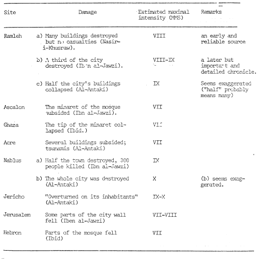
1. THE 1033-1034 A.D. SEQUENCE OF EARTHQUAKES.

a. Sources

Several destructive earthquakes occurred durL this period. Ibn al-Athir writes (A1-'amil v. IX, p. 438): "Many earthquakes occurred in Egypt and in Syria, most of them in Ramleh". According to Nasir-i- Khusraw (Safar Name) an inscription in the iamleh Mosque stated that an earthquake of great violence occurred on December 10, 1033. Al-Antaki writes: (Tarikh v, II, p. 272) that "a terrible earthquake occurred" on January 4th, 1034. However, most of the arabic sources date this earthquake on December 5th-10th, 1033 (Sharon, footnote p. 8). Abu-al-Faraj ibn al-Jawzi describes (Al-Muntazam v. VIII p. 77) the maritime effects as follows: "At the coast there (meaning the Syrian-Palestine Coast) the sea receded for a distance of nine miles, and the people walked on its exposed bed to look for fish and shells". The tsunami "killed a group of them". Al-Ataki describes (Tarikh, vol. II, p. 272) as follows the damage in Acre: "In Acre, several buildings subsided and a number of people died (as a result), the sea retreated from the harbour for an hour and then returned to its (previous) position". Abu al Faraj ibn al Jawzi notes quite explicitly that the maritime effects did not occur simultaneously with the Ramleh earthquakes. He writes (Al-Muntazam, vol. VIII, p. 77): "There were (in the same year) earthquakes in Ramla. The inhabitants escaped from the town with their children, women and slaves and stayed out,,ide the city for eight days. This earthquake destroyed, according to an estimate, one third of the town, threw down the Friday mosque and killed a number of people. It extended to Nablus, where half the buildings of the town collapsed and 300 people were ki'led. A village opposite Nablus was overturned and all its inhabitants, their cows and their sheep, were destroyed. Other villages were destroyed as well Some parts of the city wall of Jerusalem fell, including a large portion of its citadel. Part of the mosque of Abraham (in Hebron) was ruined. The minaret of the Friday mosque in Ashcalon subsided, as well as the tip of the minaret (of the mosque) of Ghana".

Al Antaki (Tarikh, vol. 11, 77; adds some information about Jericho: "The city of Jericho was overturned on its inhabitants".

According to Nasir-i-Khusraw (Safar Name) this earthquake "threw down a large number of buildings (in Ramleh), but not a single person sustained any injury".

b. Estimate of Intensities and Epicenter

The estimated seismic intensities are summed up in the following table and plotted in Figure 1 (below).

Table 1: The 1033-1034 Earthquake from Arieh (1977)

Intensity Estimates for the 1033 CE earthquake from Arieh (1977)


The estimated seismic intensities (Table 1) are as a matter of fact, almost identical to previously evaluated intensities (part 2.5.2. of the NP-1 P.S.A.R.). The seismic intensity distribution suggests an epicenter in the Dead Sea - Jordan rift system. On the other hand it is evident that the maritime effects along the Syrian-Palestine coast (tsunamis!' ) could be caused only by another earthquake somewhere offshore (not necessarily in the vicinity of Acre). It is assumed that the offshore earthquake did not cause the partial destruction of Ramleh because the seismic intensities decreased towards the coast. On the basis of seismic intensities' distribution (see isoseismal map Fig. 1, the seismic intensity at the NP-1 sire was probably VII. However, considering the uncertainty of intensity values, it could not have exceeded VIII (NMS).


Jerusalem Archeological Park (online)

Several earthquakes shook the country in Islamic times. The worst earthquake occurred on December 5, 1033, affecting the whole country. Contemporary chroniclers described in detail the consequences of this devastating earthquake, focusing on the damage caused to Jerusalem. The southern wall of the Temple Mount was destroyed and mihrab Daud, which was located either in the north of the Temple Mount or near Jaffa Gate, had collapsed.

The Fatimid caliph Al-Dhahir initiated large-scale restoration works in the damaged cities, especially in Ramla and Jerusalem. The restoration works in Jerusalem were the most extensive in its history. In the Dome of the Rock new wooden beams were affixed to support the dome. These beams are still visible today. New, splendorous mosaics covered the walls and tympanum. The Al-Aqsa Mosque also underwent restoration, which included new, magnificent mosaics on the walls and on the arch in front of the dome. The latter mosaic bears an inscription indicating the date of the restoration 1035 CE. In addition to the mosaics, wooden beams, decorated in a variety of colors, were incorporated in the ceiling of the Mosque. These wooden beams were recovered during restoration works in the Mosque in the 1930s. Other structures restored by Al-Dhahir are 'Solomon's Stables' and the outer walls of the Temple Mount enclosure, especially the southern wall.

from http://www.archpark.org.il/article.asp?id=245

[People] ran out from their houses into the streets because they saw the houses and the walls tremble, while the wooden beams separated from the walls and swayed back and forth. The buildings that had been supported by various means collapsed and the new apartments were ruined¦The earthquake took place on Thursday, the second day of the month of Teveth, all of a sudden, just before sunset, in Ramla and all the rest of the Land of the Philistines, from the fortified towns to the unwalled villages, in all the coastal fortifications until Haifa, in all the cities of the Negev and in the highland region until Jerusalem and all the towns in its vicinity, until Nablus and all the villages in its vicinity until Tiberias all the communities in its vicinity, and in the Galilee hills and in all of Palestine...

Taher (1996)

425/1033- 1034: on Safar 10 (January 10) a very violent earthquake devastates Syria and Egypt; its maximum strength manifests itself in Ramla. Ibn al-Athîr says that the inhabitants left their houses for a few days and about a third of the houses collapsed, killing many people under the rubble85.. We have several testimonies about this earthquake, Jewish, Christian and Muslim. ` Ezra Haddad86., commenting on the earthquake that occurred during the journey of Benyâmîn (561-569) (this is the earthquake of 565), writes: “This district is very famous because of the frequency of earthquakes which affected it at different times.” Among the old Jewish manuscripts, we find an article on al-Ramla which contains a magnificent description of the earthquake that occurred in Syria and Palestine on 12 tabîth (or Thursday) 425. Yahyâ b. Sa'îd al-Antâqî 87 says for his part: “The caliph al-Zâhir undertook that year to rebuild the walls of Jerusalem, after having fortified al-Ramla. The builders began to destroy many churches outside the city for the purposes of the work; they took the stones to build the walls, then, occurred this prodigious earthquake the like of which had not been seen nor heard of until then, at the end of the morning of Thursday 10 Safar . Among its damage, there are many walls destroyed, the victims amounting to a considerable number; the town of Ariha falls on its inhabitants, as well as Nablus and neighboring villages. Part of the Jerusalem mosque collapsed along with many houses and churches in the district. In Acre, too, houses collapsed on their inhabitants and the victims were numerous. The sea recedes then returns in a tidal wave. » Ibn al-Djawzi88 also mentions this.

Footnotes

85 Al-Kâmit , 9/438.

86 Travel of Benjamin of Tudela, ed. `Ezra Haddâd , Baghdâd, 1945, p. 88, 89, note 3. There is in this text, a description that E. Haddâd translates from Hebrew: ( Dinab , II, 232) “People evacuate their houses to take refuge in the streets, walls fall, ceilings crack at the top of the walls, well-built houses collapse, new buildings collapse, people perish buried ¬under rubble, unable to find safety here or there; people evacuate their homes without thinking about the belongings they leave behind. They have abandoned their possessions, cannot find a way to escape. direction they take headlong, they encounter only the will of God, then disperse. The buildings that remain standing are nevertheless cracked and have lost their balance. Faced with such horror that the eyes contemplated, that the ears heard, the brain came out of the head. These events occurred at sunset; they occurred suddenly in Ramla and throughout Palestine. The citadels and the countryside were leveled (brought) to the same level as the sea as far as Banyas , from the south of the mountain to Jerusalem and from the regions neighboring the sea to Nablus and its villages. In Tiberias and its district, we saw the mountains moving like sheep, the rocks exploded and in the forests, the trees bent, the wells overflowed and the tongue was exhausted in recounting the catastrophe. »

87 Al-Antâqî , Târîkh , 2/272, which links the earthquake to the destruction and looting of churches.

88 B. al-Djawzî , Al-Muntazam , 8/77 writes: “An earthquake ¬occurs in Ramla, people evacuate the city with their children, their wives, their slaves and spend eight days outside. The earthquake destroys a third of the city and cuts up the great mosque, kills a good part of the population, also affects Nablus where it destroys houses and kills 300 victims; he overthrows a neighboring village which is swallowed up in the earth with its people and its flocks; other villages had the same fate. Part of the walls of the mosque of Jerusalem collapses, as well as the synagogue -of David in large part, part of the tomb of Abraham is destroyed but the room is saved, the minaret of the great mosque of ` Asqalân collapsed and the top of the Ghaza minaret suffered the same fate. This year at the same time, the plague occurs in Baghdad. »

Taher (1979)

425 A.H./1033-1034 AD

Ibn Al-Athlr5 bears a testimony:

This year a very violent earthquake devastated Syria and Egypt. Its maximum force was located at Ramla. The inhabitants left their homes for a few days and a third almost all the houses collapsed, killing many people under the rubble.
Yahya ibn Sacid Al Antaky6 says for his part:
That year, Caliph Az-Zahir undertook to build the walls of Jerusalem the noble city, after having fortified Ar-Ramla. Builders began to destroy many churches outside the city taking the stones to rebuild Jerusalem's walls. Then came this prodigious earthquake the like of which had not been seen nor heard of until then, ending on the morning of Thursday 10 çafar. In terms of its damage, many walls were destroyed and there were a considerable number of victims. The city of Arriha fell on its inhabitants, as well as Nablus and neighboring villages. Part of the mosque of Jerusalem collapsed along with many houses and churches, within the circumsciption [?]. In Acre too, houses collapsed on their inhabitants and there were large numbers of victims. The sea receded and then returned in a tidal wave.
'Azra Hadad comments on the earthquake that occurred during Benyamin's journey (561-569)1a (It is the earthquake of 565). Here are his words:
This district is very famous due to the frequency of earthquakes which affected it at different times. Among the old manuscripts of the Jews, we find an article on Ramla which contains a magnificent description of the earthquake that occurred in Syria and Palestine on 12 Tabith (Thursday) 425. There is therefore in this text, a description that we translate from Hebrew.
Dinab, II,232

People evacuated their homes to take refuge in the streets, the walls fell, the ceilings cracked at the top of the walls, well-built houses collapsed, new buildings collapsed, and people were buried under the rubble, without having found their salvation here or there... People evacuated their houses without thinking about the belongings they left behind. They abandoned their possessions, which were destroyed, seeking their salvation only in themselves. Whichever direction they took, they knew they would find a miracle from God they also ran — they headed down, then dispersed. The buildings that remained standing were nevertheless cracked and had lost their stability. Faced with such horrors that the eyes saw and the ears heard, the brain came out of its head... These events occurred at sunset. They suddenly returned to Ramla and throughout Palestine. The citadels and the countryside were leveled (brought back to the same level) of the sea to Banyas, from the south of the mountain to Jerusalem and the regions neighboring the sea up to Nablus and its villages. In Tiberias and its district, we saw the mountains moving like sheep, the rocks exploded and in the forests, and the trees bent. The wells overflowed. The tongue tires to recount this catastrophe ..
Ibn al-Jawzy1b reports:
In Ramla, an earthquake occurred. The inhabitants evacuated the city with their children, their wives, and their slaves and spent eight days outside. The earthquake destroyed a third of the city, cut the great mosque, and killed a good part of the population. It then spread towards Nablus where it destroyed houses and killed 300. It overthrew a neighboring village which was swallowed up in the earth with its people and their flocks. Other villages suffered the same fate. Part of the walls of the Jerusalem mosque collapsed, as well as the synagogue of David, in large part, part of the mosque of Abraham was destroyed but the room was saved. The minaret of the Great Mosque of Ashkelon collapsed. The top of the Ghaza minaret suffered the same fate. At this same time, a plague occurred in Baghded.
We are in the presence of three sources. The Christian historian compares the earthquake to the destruction and looting of churches. The Jewish manuscript as well as the testimony by Ibn al Djawzy report the very significant damage that occurred in Palestine.
Footnotes

5 Al Kamil, 9/438.

6 Tarikh, 2/272.

1a Voyage, p.p. 88-89, Note N.3

1b Muntazim, 8/77; Ibn Chakir, 'Uyon MS., 145, 13/113.

References

Taher, M.A. (1979): Corpus des texts arabes relatifs aux tremblements de terre et autres catastrophes naturelles, de la conquete arabe au XII H/XVIII JC, Ph.D. Thesis (Univ. Paris), 337 pp.

439 A.H./1047 AD - Another earthquake in Ramla

According to Al Fariqi2, the earth shook in ar-Ramla and the people evacuated the city.

Footnotes

2 Tarikh, p.161.

References

Taher, M.A. (1979): Corpus des texts arabes relatifs aux tremblements de terre et autres catastrophes naturelles, de la conquete arabe au XII H/XVIII JC, Ph.D. Thesis (Univ. Paris), 337 pp.

460 A.H./18 March 1068 AD

On Tuesday 10 Djumada I, a prodigious earthquake occurred in Palestine3. It demolished most of the houses of Ar-Ramla, its walls, and it damaged the mosque and caused the death of many inhabitants under the rubble.

The following story is told: a teacher had with him in his school, about 200 boys. The school collapsed on them, and no one asked about them because all the parents were dead.

The wells overflowed due to the earthquake.

In Banyas, 100 victims died under the rubble, as well as in Jerusalem. That year we heard a terrible clap of thunder and never heard it so far. It was a frightful outburst. Many men, women and children lost consciousness.

After this thunderclap, enormous clouds rose, some fell, and there was an intense hailstorm which destroyed many trees. A formidable thunderstorm brought [the hailstones] and carried away everything in its path: trees and stones.

Ibn al-Athir2 reports that in Jumada I, a very violent earthquake occurred in Palestine and Egypt. The city of Ramla was destroyed, water gushed from the mouth of the wells, and there were 25 victims.

The mosque of Jerusalem was cracked and then repaired thanks to the most high God.

The sea receded a day's walk from the coast and returned to drown the people busy collecting things on the shore. There were many deaths.

Ibn al-Djawzy3

In Djumada I, a prodigious earthquake occurred in Palestine, which affected Palestine and the city of Ramla, destroying two battlements of the Prophet's mosque. Its effects were felt as far as Wàdi Aç-çafrai, Khaybar, the earth split and treasures appeared. Its effects were felt as far as Ar-Rahba and al-Kufa. Testimonies were reported by merchants, according to which the entire city of Ramla had collapsed, with the exception of two alleys. The number of victims rose to 15,000 people,
Footnotes

1 Ibn al Qalanisi, Dhayl, 94.

2 Al Kamil, 10/57.

3 Al Muntazim, 8/248.

References

Taher, M.A. (1979): Corpus des texts arabes relatifs aux tremblements de terre et autres catastrophes naturelles, de la conquete arabe au XII H/XVIII JC, Ph.D. Thesis (Univ. Paris), 337 pp.

462 A.H./1070 AD

On Tuesday 11 Djumada I at the third hour, (18 'Adhar)1, an earthquake occurred in Ramla and its surrounding, which was completely destroyed. The walls were demolished; shaking spread to Jerusalem and Tinis, Aylat was completely destroyed. The sea receded, revealing the land. People marched on the strike and the sea returned to its original position. The corner of the 'Amr mosque was distorted. This earthquake was followed by two other tremors almost immediately.

Footnotes

1 The date corresponds to the year 460;.cf. Ibn al Djawzi, al Muntazam, 8/256.

References

Taher, M.A. (1979): Corpus des texts arabes relatifs aux tremblements de terre et autres catastrophes naturelles, de la conquete arabe au XII H/XVIII JC, Ph.D. Thesis (Univ. Paris), 337 pp.

Paleoclimate - Droughts

References

References

http://www.annalsofgeophysics.eu/index.php/annals/article/view/4702/4786

Arieh, E. (1977). An Evaluation of Six Significant Historical Earthquakes, Jerusalem, Israel: Report for the Seismological Sectionof the Geologic Survey of Israel.

http://www.archpark.org.il/article.asp?id=216

Ambraseys, N. (2009). Earthquakes in the Mediterranean and Middle East: a multidisciplinary study of seismicity up to 1900. Cambridge, UK, Cambridge University Press.

http://books.google.com/books/about/Earthquakes_in_the_Mediterranean_and_Mid.html?id=x2veAAAACAAJ

ANTONOPOULOS, J. (1980). "Data from investigation on seismic Sea-waves events in the Eastern Mediterranean from 500 to 1000 A.D." Annals of Geophysics.

http://www.annalsofgeophysics.eu/index.php/annals/article/view/4702/4786

Ferry, M., et al. (2011). "Episodic Behavior of the Jordan Valley Section of the Dead Sea Fault Inferred from a 14-ka-Long Integrated Catalog of Large Earthquakes." Bulletin of the Seismological Society of America 101(1): 39-67.

http://www.bssaonline.org/content/101/1/39.abstract

Guidoboni, E. and A. Comastri (2005). Catalogue of earthquakes and tsunamis in the Mediterranean area from the 11th to the 15th century, Istituto nazionale di geofisica e vulcanologia.

http://books.google.com/books?id=1Uo9AQAAIAAJ

Karcz, I., et al. (1977). "Archaeological evidence for Subrecent seismic activity along the Dead Sea-Jordan Rift." Nature 269(5625): 234-235.

https://www.researchgate.net/publication/242863909_Archaeological_evidence_for_Subrecent_seismic_activity_along_the_Dead_Sea-Jordan_Rift
http://www.nature.com/nature/journal/v269/n5625/abs/269234a0.html
http://dx.doi.org/10.1038/269234a0
https://www.academia.edu/4321286/Archaeological_evidence_for_Subrecent_seismic_activity_along_the_Dead_Sea-Jordan_Rift

Kanari, M., et al. (2015). "On-land and offshore evidence for Holocene earthquakes in the Northern Gulf of Aqaba-Elat, Israel/Jordan." Miscellanea INGV 27: 240-243

Klinger, Y., et al. (2015). "5000 yr of paleoseismicity along the southern Dead Sea fault." Geophysical Journal International 202(1): 313-327. http://gji.oxfordjournals.org/content/202/1/313.abstract
http://www.ipgp.fr/~klinger/page_web/NewFiles/YK_gb.html

Salamon, A., et al. (2006). Tsunami Hazard to the Bay of Haifa: Historical Analysis and Selected Modeling, Geological Survey of Israel, Hebrew University.

http://www.gsi.gov.il/eng/_uploads/117haifa-tsunami-gsi-09-06-report.pdf

Salamon, A., et al. (2011). "A critical evaluation of tsunami records reported for the Levant Coast from the second millennium bce to the present." Isr. J. Earth Sci. 58: 327-354.

http://connection.ebscohost.com/c/articles/70861581/critical-evaluation-tsunami-records-reported-levant-coast-from-second-millennium-bce-present

Savage, S., K. Zamora, and D. Keller (2003). "Archaeology in Jordan, 2002 Season." Am. J. Archaeol. 107: 449â475.

http://www.ajaonline.org/newsletter/1407
http://www.jstor.org/stable/40025395

Jewish Encyclopedia

http://www.jewishencyclopedia.com/


Ancient Texts

Benj. Tud.: Benjamin of Tudela, The Itinerary of Benjamin of Tudela, text and transi. M. Adler, London, 1907.

http://books.google.com/books?id=oBWAAAAAMAAJ
http://www.jewishencyclopedia.com/articles/2988-benjamin-of-tudela
http://www.sacred-texts.com/jud/mhl/mhl20.htm
https://archive.org/details/itineraryofrabbi01benjuoft
http://en.wikipedia.org/wiki/Benjamin_of_Tudela
http://www.gutenberg.org/files/14981/14981-h/14981-h.htm

Cedrenus, G., et al. (1838). Georgius Cedrenus, Ioannis Scylitzae ope, E. Weber.

http://books.google.co.uk/books?id=WM0GAAAAQAAJ
http://en.wikipedia.org/wiki/George_Kedrenos
https://archive.org/details/georgiuscedrenu00scylgoog

Glykas, M. "Chronicle of events from the creation of the world to the death of Alexius I Comnenus."

http://en.wikipedia.org/wiki/Michael_Glycas
https://archive.org/details/michaelisglycae00leungoog

Soloman Ben Yehuda in

Mann, J (1920), The Jews in Egypt under the Fatimid Caliphs: a Contribution to their Political and Communal History Based Chiefly on Genizah Material Hitherto Unpublished, vol. 1 (translations and commentaries), Oxford: Oxford University Press.

Ya'ari A (1943) The letter of Salomon ben-Zemah in Letters of Eretz Israel. Gazit, Tel Aviv, Tel Aviv

Scylitzes, J. Synopsis of Histories

http://en.wikipedia.org/wiki/John_Skylitzes
http://users.uoa.gr/~nektar/history/tributes/byzantine_historians/joannes_scylitzes_synopsis_historiarum.htm
http://mybyzantine.wordpress.com/2013/02/23/history-of-byzantium-by-john-scylitzes/
http://scylitzes.webs.com/Scylitzes-Chronicle.htm


Arabic Texts


al-Antaki, Abu'l-Faraj Yahya ibn Sa` id (980? -1066 AD.) An Arab historian and physician, well known for his continuation of the Chronicle of Eutychius of Alexandria (see Ibn Batriq). He was a Melchite Christian, and lived in Egypt for the first forty years of his life. From 1014 onwards, he lived at Antioch under Byzantine rule. His sources are Islamic, Greek and Antiochene Christian. (288) (291) (293) (294) (298) (299)

Ibn al-Athir Izz al-Din ( 1851-76, 1872). (Kitab) al-Kamil fil-tarikh (The Complete History). (C) RHC Hist.Orient. C. J. Tornberg. Leiden, Paris.

http://en.wikipedia.org/wiki/Ali_ibn_al-Athir
http://en.wikipedia.org/wiki/The_Complete_History

Dahab. Tarikh: al-Dahabii, Tarikh al-Islam, MS BL Or. 49 and 50; Paris MS Ar. 1581; Kitab al-'ibar fi khabar man ghabara, 5 volumes, ed. S. Munajjid, Kuwait, 1960-66; Kitab duwa al-Islam al-kabir, MS BM Or. 48-50, with Dhail ed. al-Sakhawi, Hyderabad, 1919; trans. A. Negre, Damascus 1979, p. 13.

Dahab. Tarikh: al-Dahabii, Tarikh al-Islam, MS BL Or. 49 and 50; Paris MS Ar. 1581; Kitab al-'ibar fi khabar man ghabara, 5 volumes, ed. S. Munajjid, Kuwait, 1960-66;
Kitab duwa al-Islam al-kabir, MS BM Or. 48-50, with Dhail ed. al-Sakhawi, Hyderabad, 1919; trans. A. Negre, Damascus 1979, p. 13.

http://en.wikipedia.org/wiki/Al-Dhahabi
http://ar.wikisource.org/wiki/%D8%AA%D8%A7%D8%B1%D9%8A%D8%AE_%D8%A7%D9%84%D8%A5%D8%B3%D9%84%D8%A7%D9%85

Bar Hebraeus, see Abu'l-Faraj, Girgis.

al-Jawzi, Al Faraj

http://en.wikipedia.org/wiki/Abu%27l-Faraj_ibn_al-Jawzi
https://archive.org/details/mukhtasarmawduat00unse


al-Jauzi, Ibn. (1938-41). Kitab al-muntazam fi tarikh al muluk wa'l-uman. Hyderabad.

http://en.wikipedia.org/wiki/Sibt_ibn_al-Jawzi
http://en.wikipedia.org/wiki/Abu%27l-Faraj_ibn_al-Jawz

(Sawirus), M. I. a.-M. (1943). History of the Patriarchs of the Egyptian Church. A. a.-M. and and Burmester. Cairo.

http://www.tertullian.org/fathers/severus_hermopolis_hist_alex_patr_00_eintro.htm
http://en.wikipedia.org/wiki/History_of_the_Patriarchs_of_Alexandria
http://en.wikipedia.org/wiki/Severus_ibn_al-Mukaffa
http://www.tertullian.org/fathers/severus_hermopolis_hist_alex_patr_00_intro.htm

Ibn Shakir al-Kutubi, Uyun, MS BM Or. 3005 f. 112b.

Khusrau, in Le Strange (1890), pp. 306-7.

Le Strange, G. (1890). "Palestine under the Moslems A description of Syria and the Holy Land from A.D. 650 to 1500."

http://books.google.com/books?id=4HCPLpB3C8UC
https://archive.org/details/palestineundermo00lest

al-Suyuti, J. a.-D. K. (1971). Kashf al-salsala 'an wasf al-zalzala. A. a.-L. Sa'adan. Fez.

http://makashfa.wordpress.com/2014/01/08/works-books-of-imam-jalaluddin-suyuti/
http://en.wikipedia.org/wiki/Al-Suyuti

al-'Ulaimi (1866 (A.H. 1283)). al-Uns al-jalil bi-tarikh al-Quds. wa'l-Khalil. Cairo.

Yahia R: Yahia b. (1883). Said al-Antaki. Imperator Vasilij Bolgarobojca, izvlechenja iz letopisi Jahi Antiohijskogo. Rosen. St Petersburg.
Yahia R: Yahia b. Said al-Antaki, in Rosen's Imperator Vasilij Bolgarobojca, izvlechenja iz letopisi Jahi Antiohijskogo, St Petersburg, 1883.
Yahya b. Said: Yahia b. Said al-Antaki, Dhail tarikh Sa'id b. Bitriq, ed. Cheikho et al., CSCOScript.Arab series 3, vol. 7, Paris, 1909;
Also ed. and trans. I. Kratchkovsky and A. Vasiliev, in PO vol. 18, pp. 705-833, vol. 23, pp. 349-520, Paris.
Yahia b. Said: Yahia b. Said al-Antaki, ed. L. Cheikho in CSO, Scripy Arabici, series 3, vol. 7, Paris, 1909.

Yaqut al-Hamawi, Mu jam al-buldan, ed. F. Wfistenfeld, Leipzig, 1866-73, 4 volumes.

https://archive.org/details/YaqutMudjamAlBuldamDeir
http://en.wikipedia.org/wiki/Mu%27jam_Al-Buldan
http://en.wikipedia.org/wiki/Yaqut_al-Hamawi