| Text (with hotlink) | Original Language | Biographical Info | Religion | Date of Composition | Location Composed | Notes |
|---|---|---|---|---|---|---|
| Damage and Chronology Reports from Textual Sources | n/a | n/a | n/a | n/a | n/a | n/a |
| Ibn Tagri Birdi | Arabic |
|
Muslim | 15th c. CE | Cairo |
|
| as-Suyuti | Arabic |
|
Sufi Muslim | 15th c. CE | Cairo |
|
| Mujir al-Din | Arabic |
|
Hanbali Sunni Muslim | ca. 1495 CE | Jerusalem |
|
| Ibn Iyas | Arabic |
|
Muslim | before 1522 CE | Egypt |
|
| Other Authors | n/a | n/a | n/a | n/a | n/a |
|
| Text (with hotlink) | Original Language | Biographical Info | Religion | Date of Composition | Location Composed | Notes |
| Aliases | Arabic |
|---|---|
| Al-Suyuti | |
| As-Suyuti | |
| Jalal al-Din al-Suyuti | |
| Abu 'l-Fadl 'Abd al-Rahman ibn Abi Bakr ibn Muhammad Djalal al_Din al-Khudayri |


| Year | Reference | Corrections | Notes |
|---|---|---|---|
| 8 Nov. 1458 - 27 Oct. 1459 CE | A.H. 863 | none | Calculated using CHRONOS |
| Location (with hotlink) | Status | Intensity | Notes |
|---|---|---|---|
| Karak | Rebuilding efforts may have removed destruction evidence leaving rebuilding evidence instead. | ||
| Petra - Introduction | n/a | n/a | n/a |
| Petra - Jabal Harun | possible | ≥ 8 | Phase 12 destruction event - not well dated -
Mikkola et al (2008) noted that in this destruction event all remaining roof structures collapsed and there was a layer of stone tumble. Hard-packed, clayey soil directly under the lowermost deposits of stone tumble [...] contained relatively few findsapparently making it difficult to date. Also found in the stone tumble were the remains of two fallen arches, a row of voussoirs, some drums fallen froma column, and many other architectural elements found throughout the complex. |
| Petra - Petra Church | possible | ≥ 8 | Fiema et al (2001) characterized structural destruction of the church in Phase X as likely caused by an
earthquake with a date that is not easy to determine. A very general terminus post quemof the early 7th century CE was provided. Destruction due to a second earthquake was identified in Phase XIIA which was dated from late Umayyad to early Ottoman. Taken together this suggests that the first earthquake struck in the 7th or 8th century CE and the second struck between the 8th and 16th or 17th century CE. |
| Petra - Blue Chapel and the Ridge Church | possible | Later undated earthquake(s)- Perry in Bikai et al (2020:70) noted that from the 8th c. A.D. on, the abandoned structures suffered extensive damage from repeated earthquakes. |
|
| Shivta | possible | ≥ 8 | Erickson-Gini (2013) identified earthquake collapse at Shivta which she
dated to possibly in the Middle Islamic periodafter the site was abandoned at the end of the Early Islamic period.Korjenkov and Mazor (1999a) identified a post Byzantine earthquake which struck after 7th century CE abandonment. The terminus ante quem for this earthquake is not well established. Korjenkov and Mazor (1999a) estimated an Intensity of 8-9 for the post Byzantine earthquake and placed the epicenter a few tens of kilometers away in the WSW direction. They also report that a site effect is not likely at this location. |
| el-Lejjun | possible | ≥ 8 | 4th Earthquake - ~600 CE - 1918 CE - Groot et al (2006:183) report discovery of a
nearly complete Umayyad Lamp in Square 4 of Area B (Barracks - B.6.038) in the Post Stratum Gap - above and later than the 3rd earthquake layer.
Above the Ummayyad lamp was a 0.7 m thick layer of tumble containing some roof beams and many wall blocks(Groot et al, 2006:183). They note that the basalt roof beams found embedded in the lowest tumble level (B.6.032) suggests initial massive destruction rather than gradual decay over time. The wall blocks, found in the upper layer of tumble, contained one late Islamic (1174-1918 CE) and one Ayyubid/Mamluk (1174-1516 CE) sherd indicating a significant amount of time may have passed between the possibly seismically induced roof collapse and the wall collapse which was not characterized as necessarily having a seismic origin. This opens up the possibility that one of the mid 8th century CE earthquakes or a later earthquake may have also caused damage at el-Lejjun. deVries et al (2006:196) suggests that Umayyad abandonment of the northwest tower was probably triggered by further major collapse. In the North Gate, deVries et al (2006:207) found evidence of full scale destruction in layers above 3rd earthquake debris and post-earthquake occupation layerswhich contained Late Byzantine/Umayyad and Umayyad sherds. Subsoil/tumble was found in C.9.008 (north room), C.9.009 (south room) and C.9.005 (stairwell) bear ample witness to the destruction of the rooms, perhaps in the Umayyad period. Although Late Byzantine sherds were found in Post Stratum layers in the North Gate, if one assumes that the 3rd earthquake was the Inscription at Aeropolis Quake which struck before 597 CE - probably within a decade of 597 CE, one can establish an approximate and fairly conservative terminus post quem for this earthquake of ~600 CE. While the terminus ante quem is the end of the post stratum III gap (1918 CE), it is probable that that the earthquake struck much earlier. |
| Castellum of Qasr Bshir | possible | ≥ 8 | Later Earthquake(s) - Above what was presumed to be a Late Umayyad collapse layer
Clark (1987:490) found another collapse layer in H.2
A period of abandonment followed [the Late Umayyad collapse], punctuated by a squatter occupation of the room, during which a fire was lit in the corner. There followed a major collapse of masonry, after which no further occupation of the room took place. |
| Location (with hotlink) | Status | Intensity | Notes |
| Location (with hotlink) | Status | Minimum PGA (g) | Likely PGA (g) | Likely Intensity1 | Comments |
|---|---|---|---|---|---|
| Gulf Of Aqaba | possible | Turbidites in numerous R/V Thuwal Cores - ~1500-~1600 CE (1σ) Bektaş et al. (2024:12) report that numerous coeval turbiditeswere identified in R/V Thuwal Cores which, based on Probability Density Functions (PDFs) presented in Fig. 8 of their paper, should have been deposited between ~1500 and ~1600 CE (1σ). A sedimentary event was identified from around this time in 15 or 16 of 18 R/V Thuwal Cores of which 12 or 13 were Type I (Turbidite Event) and 3 were Type II (Turbidite or Flooding Event). The 3 Type II Events were identified in Core 2 in the Tiran Deep and cores 9 and 10 in the Dakar Deep. No turbidites from around this time were identified in Core 6 which was collected from a small and isolated basinwhich was isolated from turbidity flows that would come from the main slopes of the gulfand, due to its relatively smaller slopes, may not be sensitive to earthquake shaking as much as the larger main slopes of the gulf. A missing turbidite from core 14 was more difficult to explain. Bektaş et al. (2024:12) suggested two possibilities for its absence
triggered seismo-turbidites along the entire gulfand suggested that, when one adds paleoseismic observations by Kanari et al. (2020) from the Elat Sabhka Trenches, the CE 1588 earthquake likely [] ruptured the entire fault system in the Gulf of Aqaba1. They added that the earthquake or earthquake and aftershock does not seem to have propagated inland beyond the northern end of the gulfand ruptured south of the Tiran Strait. They surmised that the causitive earthquake did not propagate inland due to an absence of a seismic event from around this time in the Qatar Trench. 7 cm. thick Mass Transport Deposit Event B was identified in R/V Mediterranean Explorer Canyon Core P27 by Kanari et al (2015) and Ash-Mor et al. (2017). Ash-Mor et al. (2017) provided an unmodeled 14C date of ~1292 CE (658 ± 34 cal years BP) for the sediments below the mass transport deposit which Kanari et al (2015) associated with the 1458 CE earthquake although other events might also fit this approximate unmodeled date - e.g. the 1068 CE Earthquake, 1212 CE Earthquake, and the 1588 CE Earthquakes. Kanari et al (2015) based their date assignment of 1458 CE at least partly on their work in the nearby Elat Sabhka Trenches where Kanari et al. (2020) dated Event E2 in Trench T3 to after 1294 CE and listed earthquakes of 1458 CE and 1588 CE as likely candidates. Kanari et al. (2020) also identified liquefaction sand blows SB1 and SB2 in the same Elat Sabhka Trench (T3) which they dated to between 1287 and 1635 CE or 1287-1550 CE1. Kanari et al. (2020) surmised that the data for liquefaction sand blows SB1 and SB2 tend to support an interpretation of 1458 CE, but are inconclusive. |
|||
| Location (with hotlink) | Status | Minimum PGA (g) | Likely PGA (g) | Likely Intensity1 | Comments |
| Location (with hotlink) | Status | Intensity | Notes | ||||||||||
|---|---|---|---|---|---|---|---|---|---|---|---|---|---|
| Jordan Valley - Tell Saidiyeh and Ghor Kabed Trenches | unlikely to possible | ≥ 7 | Ferry et al (2011) detected 12 surface rupturing seismic events in 4 trenches (T1-T4) in Tell Saidiyeh and Ghor Kabed; 10 of which were prehistoric. The tightest chronology came from the Ghor Kabed trenches (T1 and T2) where Events Y and Z were constrained to between 560 and 1800 CE. | ||||||||||
| Dead Sea - Seismite Types | n/a | n/a | n/a | ||||||||||
| Dead Sea - En Feshka | no evidence | The top of Kagan et. al. (2011)'s section in En Feshka began around 1300 CE. | |||||||||||
| Dead Sea - Nahal Darga | possible | ≥ 7 | Enzel et. al. (2000) identified a 25-50 cm. thick seismite in coarse grained lithology in Deformed Unit 10 at the base of Stratigraphic Unit 13 which dated to 1450-1550 CE (~ 400-500 yrs BP). | ||||||||||
| Dead Sea - En Gedi | possible | 8.3 - 9.1 |
|
||||||||||
| Dead Sea - Nahal Ze 'elim | possible | 8.2 - 9.0 | Ken-Tor et al (2001a) did not encounter any seismites at site ZA-1 whose age ranges encompassed 1458 CE. At site ZA-2, Kagan et. al. (2011) encountered a 10 cm. thick Type 4 seismite which was dated to ~1525 CE ± 125. The date was not within their Bayesian modeled range and was extrapolated. Kagan et. al. (2011) suggested that this particular seismite formed during an earthquake in 1458 CE. | ||||||||||
| Araba - Introduction | n/a | n/a | n/a | ||||||||||
| Araba - Qasr Tilah | possible | ≥ 7 | Haynes et al. (2006) dated Event I to 1515-1918 CE. | ||||||||||
| Araba - Taybeh Trench | possible | LeFevre et al. (2018) assigned a 1458 CE date to a seismite labeled as E2 which was age modeled to 1581 CE ± 133. | |||||||||||
| Araba - Qatar Trench | possible | ≥ 7 | Klinger et. al. (2015) identified one seismic event which fits.
|
||||||||||
| Araba - Taba Sabhka Trench | possible | ≥ 7 | Allison (2013) assigned a 1068 CE date to a seismic event which they dated to between 1045 and 1661 CE and Allison (2013) assigned a 1212 CE date to a seismic event which they dated to between the mid 11th century CE and the 16-17th centuries CE. | ||||||||||
| Araba - Elat Sabhka Trenches | possible | Kanari et al (2020) dated Event E2 in Trench T3 to after 1294 CE and assigned it to earthquakes in 1458 or 1588 CE. Kanari et al (2020) dated sand blows SB1 and SB2 in Trench T3 to between 1287 and 1635 CE and suggested they may have formed during an earthquake in 1458 CE. | |||||||||||
| Araba - Trenches in Aqaba | possible | ≥ 7 |
Niemi (2011:153) noted that the most recent scarp-forming event fault [in Trench AQ-1] occurred after A.D. 1045-1278 based on a corrected, calibrated radiocarbon age from charcoal collected from a buried campfire at the base of the scarp in Trench T-1. This likely represents fault motion in one of the historical earthquakes affecting southern Jordan (e.g. 1068, 1212, 1458, or 1588). |
||||||||||
| Location (with hotlink) | Status | Intensity | Notes |
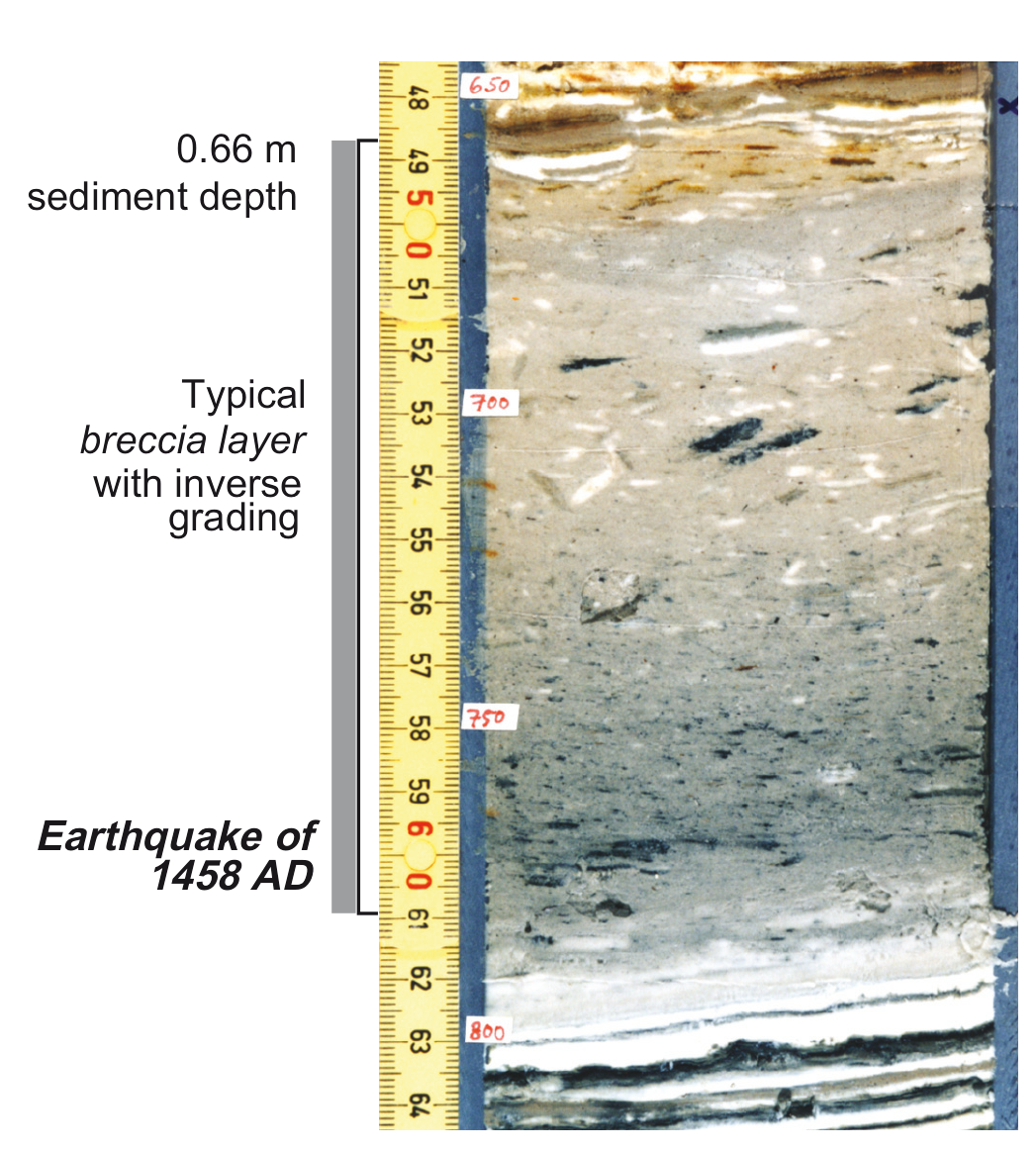 Figure 9
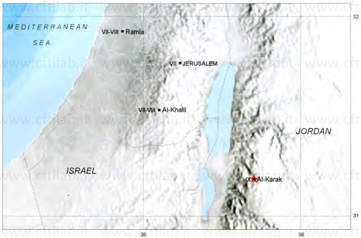
Fig. 127 (Guidoboni and Comastri, 2005 )
(324) 1458 November 8 or 16 Al-Karak [western Jordan]
On Thursday 9 [of Muharram = 16 November 1458], there was a minor earthquake at new Cairo, but it was sufficiently strong in Syria to cause the collapse of most of the town walls, the government building and many dwellings in the town of Karak. Furthermore, the minaret collapsed in the town of Ramla, as well as another minaret at Khalil, part of a minaret in Jerusalem and the great dome which was close to the Qumama [the church of the Holy Sepulchre].In Nujum, Ibn Taghribirdi simply records the earthquake effects at Al-Karak:
At the beginning of the month [of Muharram] there was a terrible earthquake in the town of Karak, which destroyed various parts of the citadel, including houses and towers. It was Wednesday [8 November].Al-Ulaimi mentions some effects at Jerusalem, his native city:
A minaret overlooks the Zawiya al-Darka [a building in the city], part of which was destroyed in the earthquake which occurred in the month of Muharram 863 [of the Hegira = 8 November - 7 December 1458].The information provided by Ibn Iyas is in more general terms:
In that month [Muharram], there was an earthquake in new Cairo, but it was slight. A similar one occurred in the region of Syria, but there it was a strong and violent shock, causing the collapse of a great number of houses in Jerusalem and Khalil.al-Suyuti specifies the number of victims at Al-Karak, which does not appear in the other sources:
A violent earthquake destroyed a large part of the citadel and its towers at Karak. A hundred people were killed" [863 H. = 8 November 1458 - 27 October 1459].Poirier and Taher (1980, p.2193) date this earthquake generically to the year 1459 and give the single locality of Al-Karak an intensity of grade VIII MM. Amiran et al. (1994, pp.270-1) give three incorrect dates (1456, 1457 and 1459) for this event, though they indicate that it may have been a single occurrence. Ambraseys et al. (1994, pp.49-50) prefer to date the earthquake to 12 November 1458, because two other unpublished Arab authors agree on that date, and give it an epicentral intensity of class D which is equivalent in their classification to a range from between damaging and destructive (approximately VII to IX MSK).

Fig. 2.16 1458 November 12, Dead Sea. (Ambraseys et al, 1994)
1458 November 12 Sunday 5 Muharram 863 Dead Sea
A damaging earthquake in southern Palestine was weakly
felt in Cairo (see Figure 2.16). It destroyed parts of the
citadel of al-Karak, including towers and parts of the
walls, as well as the governor's palace and many houses.1
It is reported that 100 people were killed in al-Karak.2
The shock destroyed minarets in al-Ramla, Ludd and
Hebron (al-Khalil).3 In Jerusalem, the top part of the
minaret over the Zawiya al-Darkah was thrown down
and a dome near the Church of the Holy Sepulchre was
destroyed.4