| Text (with hotlink) | Original Language | Biographical Info | Religion | Date of Composition | Location Composed | Notes |
|---|---|---|---|---|---|---|
| The Jewish War and Jewish Antiquities by Josephus | Greek, possibly translated from an earlier version in Aramaic |
|
Jewish | about 75 CE and 95 CE | Rome and ? | Josephus Flavius wrote about the earthquake in two different books - The Jewish War written around 75 CE and then again in Jewish Antiquities written around 95 CE. Neither account specifies a city or village damaged and both are unspecific about the location of the earthquake. However, both accounts describe a powerful earthquake. The Jewish War dates the earthquake to the spring of 31 BCE while Jewish Antiquities dates it to the fall of the same year. Jewish Antiquities appears to be better sourced than the Jewish War. |
| Chronographia by Johannes Malalas | Greek |
|
Christian (Orthodox Byzantium) | ~530s to 565 CE | Probably Antioch and Constantinople | Johannes Malalas provides an account of an earthquake with confused chronology and geography however there are indications in the text which suggest that, if this refers to the same earthquake as the one recounted by Josephus, Lod received damage. |
| Historical Arguments Against a larger earthquake | ||||||
| Text (with hotlink) | Original Language | Biographical Info | Religion | Date of Composition | Location Composed | Notes |
| Location (with hotlink) | Status | Intensity | Notes |
|---|---|---|---|
| Jerusalem - Introduction | n/a | n/a | n/a |
| Jerusalem - Second Temple | possible | Ben-Menahem (1991), without specifically citing a source, lists damage to the Second Temple in Jerusalem. He likely made this assertion due to the Second Temple rebuilding project initiated by King Herod in ~19 BCE. Damage to the second Temple from the 31 BCE earthquake and other indignities (e.g. prior earthquakes and wars) may have formed the justification for the rebuilding project. | |
| Jerusalem - Jason's Tomb | probable | ≥ 8 | Rahmani(1964:98-99) interpreted the collapse of “structured parts” of Jason’s Tomb in Jerusalem to be due to the 31 BCE earthquake. He noted the presence of Herodian remains (mainly oil lamps) on a plaster floor beneath earthquake debris. Since Herod conquered Jerusalem in 37 BCE and Rahmani (1964) dates sealing of the tomb to 30/31 CE, it was presumed that the responsible earthquake was the only one that Rahmani (1964) was aware of at that time – the Josephus Quake of 31 BCE. However, since then evidence for the Jerusalem Quake of 26-36 CE has come to light making the Jerusalem Quake another possible candidate for the collapse debris. If the Jerusalem Quake did cause archeoseismic damage to Jason’s Tomb, it may have added additional debris rather than being responsible for the original debris. |
| Qumran | possible | ≥ 8 | Phase Ib Earthquake - 1st century BCE - Roland de Vaux, the original excavator of Qumran, interpreted a destruction layer between Periods Ib and 2 which he attributed to an earthquake (in 31 BCE) and a fire which caused the settlement to be abandoned for several decades. This interpretation has been challenged - particularly the several decade long abandonment. Magness (2002), for example, proposed a revised chronology which subdivided Phase Ib into two sub-phases - before and after a 31 BCE earthquake. The fire and subsequent abandonment was presumed to have occurred almost 30 years after the earthquake. Magness (2002) suggested that the fire was due to human agency caused by military activity and/or unrest in the area. For archaeoseismic purposes, most chronologies of Qumran agree that the site was impacted by the 31 BCE Josephus Quake earthquake with Hirschfeld, who excavated nearby En Feshka, as a notable exception. |
| En Feshka | no evidence | ≥ 8 | Destruction by Fire and War - Hirschfeld (2004b) reported on his excavations at En Feshka where he did not encounter archaeoseismic evidence.
Hirschfeld (2004b:44) surmised that construction of the complex north of the spring began in the reign of Herod (37-34 BCE), and it was in use until its destruction around 130 CE, a period of approximately 150-160 years. Hirschfeld (2004b:42) reports that the main building at Ein Feshka yielded evidence for its destruction in a fierce fireand the site was destroyed in the second half of the first century, almost certainly during the Second Revolt. The second revolt (aka the Bar Kokhba revolt) lasted from 132-136 CE. Hirschfeld (2004b:55) discovered an iron arrowhead embedded in the southern wall of the northern wing (W7), close to the place where signs of fire were discernedwhich he presumed was associated with the destruction of the building during the Second Revolt [aka the Bar Kokhba revolt]. |
| Jericho and environs - Introduction | n/a | n/a | n/a |
| Jericho - Tel Abu Alaik | possible | ≥ 8 | King Herod received a Hasmonean Winter Palace at Jericho which may have been destroyed by the 31 BCE earthquake.
Herod subsequently rebuilt a palace at a different but nearby location on top of a damaged synagogue.
Roller (1998) notes that the original Hasmonean palace remained in use until the
30's BCE "as the drowning of Aristobulus in 36 BCE demonstrates"
(see Antiquities of the Jews Book XV Chapter 3 Paragraph 3). This would indicate that
Ambraseys (2009) was mistaken in his assertion that it is more probable
that the structure was destroyed by war when Herod conquered Jericho in 39 BCE taking it from Antigonus II Mattathias
the last Hasmonean King of Judea.
Karcz et al (1977) reports that a strong earthquake in 31 BCE destroyed the palace. |
| Heshbon | possible | ≥ 8 |
Mitchel (1980) identified a destruction layer in Stratum 14
which he attributed to an earthquake. Unfortunately, the destruction layer is not precisely dated. Using some assumptions,
Mitchel (1980) dated the
earthquake destruction to the 130 CE Eusebius Mystery Quake,
apparently unaware at the time that this earthquake account may be either
misdated as suggested by Russell (1985) or mislocated as
suggested by Ambraseys (2009).
Although Russell (1985) attributed the destruction layer
in Stratum 14 to the early 2nd century CE Incense Road Quake, a number of
earthquakes are possible candidates including the 31 BCE Josephus Quake. bedrock surface channels, presumably for directing run-off water into storage facilities, which now are totally disrupted, and in many cases rest ten to twenty degrees from the horizontal; by caves with carefully cut steps leading down into them whose entrances are fully or largely collapsed and no longer usable; by passages from caves which can still be entered into formerly communicating caves which no longer exist, or are so low-ceilinged or clogged with debris as to make their use highly unlikely — at least as they stand now.Mitchel (1980:73) also noticed that new buildings constructed in Stratum 13 were leveled over a jumble of broken-up bedrock. Mitchel (1980:95) reports that Areas B and D had the best evidence for the massive bedrock collapse - something he attributed to the "softer" strata in this area, more prone to karst features and thus easier to burrow into and develop underground dwelling structures. Mitchel (1980:96) reports discovery of a coin of Aretas IV (9 BC – 40 CE) in the fill of silo D.3:57 which he suggests was placed as part of reconstruction after the earthquake. Although Mitchel (1980:96) acknowledges that this suggests that the causitive earthquake was the 31 BCE Josephus Quake, Mitchel (1980:96) argued for a later earthquake based on the mistaken belief that the 31 BCE Josephus Quake had an epicenter in the Galilee. Paleoseismic evidence from the Dead Sea, however, indicates that the 31 BCE Josephus Quake had an epicenter in the vicinity of the Dead Sea relatively close to Tell Hesban. Mitchel (1980:96-98)'s argument follows: The filling of the silos, caves, and other broken—up bedrock installations at the end of the Early Roman period was apparently carried out nearly immediately after the earthquake occurred. This conclusion is based on the absence of evidence for extended exposure before filling (silt, water—laid deposits, etc.), which in fact suggests that maybe not even one winter's rain can be accounted for between the earthquake and the Stratum 13 filling operation. If this conclusion is correct, then the Aretas IV coin had to have been introduced into silo D.3:57 fill soon after the earthquake. which consequently could not have been earlier than 9 B.C.Mitchel (1980:100)'s 130 CE date for the causitive earthquake rests on the assumption that the "fills" were deposited soon after bedrock collapse. If one discards this assumption, numismatic evidence and ceramic evidence suggests that the "fill" was deposited over a longer period of time - perhaps even 200+ years - and the causitive earthquake was earlier. Unfortunately, it appears that the terminus ante quem for the bedrock collapse event is not well constrained. The terminus post quem appears to depend on the date for lower levels of Stratum 14 which seems to have been difficult to date precisely and underlying Stratum 15 which Mitchel (1980:21) characterized as chronologically difficult. |
| Tel Ateret aka Vadun Jacob | indeterminate | Ellenblum et. al. (2015) estimate ~1.5 meters of fault slip occurred on the site between its abandonment probably in the middle of the first century BC and when a Crusader fortress was built at the end of the 12th century CE. Due to the sites abandonment and lack of identified new constructions during this time, it is difficult to resolve the ~1.5 meters of slip into individual earthquake events. However, abandonment of the site may have been precipitated by an earthquake. The latest Hellenistic coin excavated from the site dates to 65/64 BCE indicating desertion of the site occurred afterwards. | |
| Khirbet Tannur | possible | There is no evidence using McKenzie et al (2013)'s chronology instead of Glueck (1965)'s chronology however a dedicatory inscription dated to 8/7 BCE suggests that there may have been seismic damage prior to 8/7 BCE. | |
| Iraq el-Amir | indeterminate | El-Isa (1985) noted seismic effects at Iraq el-Emir however no archeological dating was provided. El-Isa (1985) speculated that the causitive earthquake may have been the Josephus Quake of 31 BCE. | |
| Location (with hotlink) | Status | Intensity | Notes |
| Location (with hotlink) | Status | Minimum PGA (g) | Likely PGA (g) | Likely Intensity1 | Comments |
|---|---|---|---|---|---|
| Jordan River Delta | possible | Niemi and Ben-Avraham (1994) estimated that Event 2 was younger than 3-5 ka and older than 1927 CE. | |||
| Location (with hotlink) | Status | Minimum PGA (g) | Likely PGA (g) | Likely Intensity1 | Comments |
| Location (with hotlink) | Status | Intensity | Notes |
|---|---|---|---|
| Tekieh Trenches | possible to unlikely | ≥ 7 | Gomez et. al. (2003:15) may have seen evidence for an earthquake in the 1st or 2nd century BCE in Event B. Event B is estimated to have created ~ 2 meters of left lateral strike slip displacement which translates to an estimated Magnitude between 7.0 and 7.3 (7.0 and 7.2 according to Gomez et al, 2003:16-17). In terms of dating, an upper bound for Event B is 170 BCE - 20 CE while a lower bound for Events B and and the older Event C is from 1690 - 1400 BCE. |
| Bet Zayda | possible | ≥ 7 | Event CH4-E6 (modeled age 392 BCE – 91 CE) from Wechsler at al. (2014) could have been caused by the Josephus Quake. |
| Jordan Valley - Dir Hagla Trenches | probable | ≥ 7 | Reches and Hoexter (1981) report that Event A was dated from 200 BCE - 200 CE and exhibited 3.5 m of vertical displacement. Although the total vertical displacement could have been created by more than one seismic event, there were no broken layers between Event A the next Event (B) which was dated to between 700 and 900 CE. Further, they interpreted Event A created a fault scarp on the site. Kagan, E., et al. (2011) noted that the dip slip could have been magnified by local variations in the strike of the fault. |
| Dead Sea - Seismite Types | n/a | n/a | n/a |
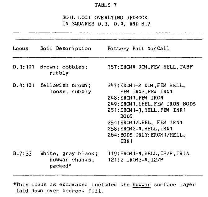
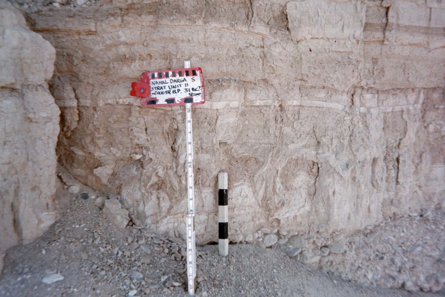
| Dead Sea - Nahal Darga | probable | ≥ 7 |
|
| Dead Sea - En Feshka | <probable | 7.9 - 8.8 | Kagan et al (2011) report a 1 cm. thick Type 4 microbreccia seismite at a depth of 364.0 cm. with modeled ages of 25 BCE ± 32 (1σ) and 25 BCE ± 71 (2σ). They assigned this seismite to the 31 BCE Josephus Quake. |
| Dead Sea - En Gedi | probable | 8.2 - 9.0 | Migowski et. al. (2004) dated a 9 cm. thick Type 4 seismite at a depth of 283.86 cm. (2.8386 m) to 31 BCE. |
| Dead Sea - Nahal Ze 'elim | probable | 8.1-9.3 |
|
| Araba - Introduction | n/a | n/a | n/a |
| Araba - Taybeh Trench | possible | ≥ 7 | LeFevre et al. (2018) tentatively identified a poorly expressed seismic event (E5) in the Taybeh trench in the Araba which they modeled between 14 BCE and 205 CE. Although they identified the 31 BCE Josephus Quake as the most likely candidate, the ~31 CE Jerusalem Quake may be an even more likely candidate. LeFevre et al. (2018) noted that the poor expression of Event E5 (vertical cracks in the trench) meant that the cracks could have been caused by a later Event (E4) which they associated with the early second century CE Incense Road Earthquake. |
| Araba - Qatar Trench | no evidence | ≥ 7 | Klinger et. al. (2015) did not observe any seismic events whose time window encompassed 31 BCE. |
| Location (with hotlink) | Status | Intensity | Notes |
 Figure 2c
 Figure 2
Photo taken by Jefferson B. Williams in May 2000
Figure 2
Photo taken by Jefferson B. Williams in May 2000
| Date (with hotlink) | Notes |
|---|---|
| 13th year of Herod's Rule | |
| Date (with hotlink) | Notes |