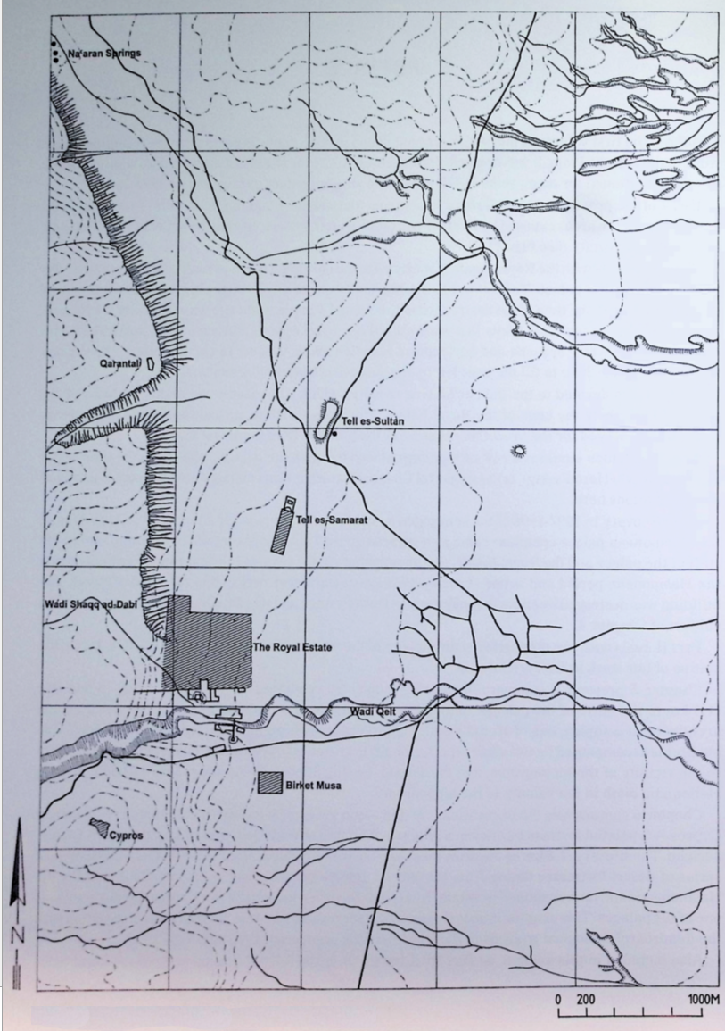
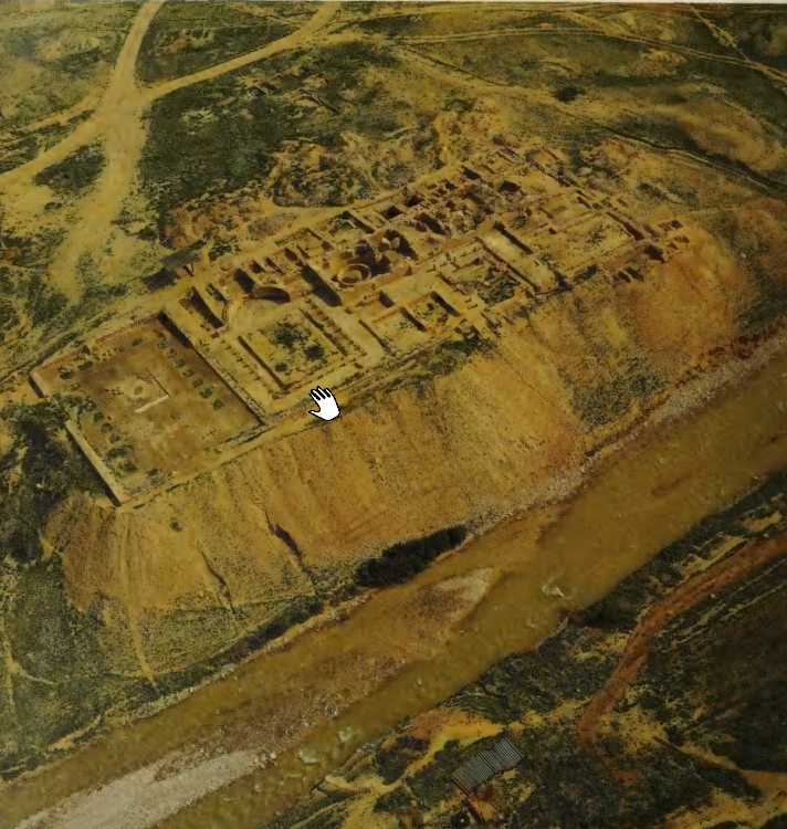
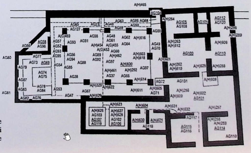
The main element of the Synagogue Complex consisted of a
pillared hall [A(H)600] with a small niche (AG104) appended to
its northeastern corner (see Plans 25, 26). The hall, entered
from the east close to its southeastern corner, was from the
outset surrounded by raised aisles, the front sides of which
functioned as benches bordering the nave (see Ill. 181). In the
hall's initial stage, additional benches might have existed
along the western and northern walls. On the west, one bench was
apparently built along wall W696, but was demolished during the
renovations implemented in the complex's final, third phase (the
addition of the triclinium and the kitchen). On the north, one
or two benches seem to have existed, but they were apparently
looted after the synagogue had gone out of use. A north-south
channel, descending from the higher-located Nacaran Conduit,
bisected the hall below its floor. It conveyed water to the
ritual bath on the south, and also supplied water to a small
basin, incorporated in the northern aisle's front bench.
The synagogue hall was slightly trapezoidal in shape,
12 with a
length of 16 m in the north and 16.3 m in the south, and a width
of 11.15 m (all inner dimensions). It was bounded on the north
by wall W554 (1.1 m wide), the western continuation of wall
W955,
13 situated ca. 50 cm from the southern sidewall of the
Nacaran Conduit. The bottom part of wall W554 served as a
retaining wall for the virgin soil behind it. On the east, the
hall was bounded by wall W342 (70 cm wide), faced by cobbles and
with small pebbles forming the core, all bonded with mud. This
wall predated the construction of the hall, serving as the
western wall of the Courtyard House on the east, and all the
east-west walls of the hall and the bathing facilities (aside
from W554 on the north) were built abutting it. On the south,
the hall was bounded by wall W343 (75 cm wide), built in a
similar manner to wall W342 but abutting it, and on the west by
wall W696,
14 most of which was demolished when the triclinium
and the kitchen were added, leaving only the northernmost 1.5 m
intact (see below). The lower part of the remaining section (up
to 1 m above the floor of the aisle) functioned as a retaining
wall for the virgin soil behind it, and above this level, the
wall was freestanding, with an assumed width of 75 cm.
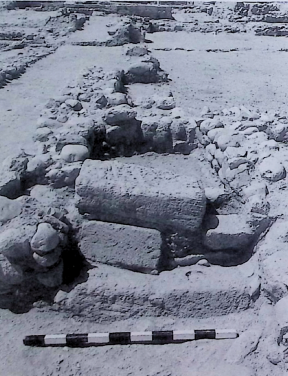
The hall was entered from Courtyard AG101 on the east (see
above) through a 1-m-wide doorway in wall W342, 2.45 m to the
north of its southern end (more or less opposite the hall's
southeastern pillar). Since the courtyard's floor level was ca.
90 cm below that of the hall's aisles, a rather uncommon
solution was found for this difference in height.
Inside the
doorway (between the doorjambs), three ashlar steps15 led up to
a landing of sorts inside the hall's confines (see Ill. 182).
16
This landing was bounded on the north and south by short walls
built between wall W342 on the east and W1180 (the eastern bench)
on the west, which actually served as additional steps to the
eastern and southern aisles.
The hall's ceilings
17 were borne by twelve pillars located
between the nave and the aisles. Five of these supports,
positioned at more or less regular intervals of 2.1 m, were
located along both of the longer aisles on the north and south,
at a distance of 1.5 m from the walls behind them. Worthy of
mention is the fact that, whereas the three central pillars in
these rows were longitudinally parallel to these walls, the
corner ones were rotated 90°, being parallel to the eastern and
western walls. Midway between the eastern corner pillars — at a
distance of 2.7 m from them — was located another pillar (all of
them 1.35 m from the eastern wall). It seems that originally, a
similar, central pillar also existed on the west. However, the
pillar exposed here (which must have replaced the initial one)
was located some 65 cm to the north of the building's
longitudinal axis, 3.8 m to the north of the southwestern pillar
and only 1.6 m to the south of the northwestern one (all of them
1.75 m from the western wall)
18. To the north of this pillar, an
ashlar step (its top at a level of +94.61) was inserted into the
low front wall (bench) of the western aisle (see Ill. 183). It
was 70 cm long and 35 cm wide.
19 The pillars were rectangular
in shape and of slightly varying dimensions (averaging 85 × 70 cm
in size), and the best-preserved one attained a height of 50 cm
above the hall's floor. They were built of fairly large
fieldstones and cobbles bonded with mud,
20 and they were coated
with white lime plaster on all four sides. The bottom parts of
the pillars were partly engaged within the benches, in such a
manner that more than half of their width projected into the
hall. Worthy of mention in this respect is the fact that the
base of the plaster coating on the pillars corresponds to the
relative floor levels here. Thus, the base of the plaster on the
sides facing the aisles was some 45 cm above that on the sides
facing the nave (see Ill. 183).
21 However, no plaster was found
on the front sides of the adjacent low walls/benches.
The nave, surrounded by the aisles, was ca. 12.4 m long and 7.6
m wide. Its floor was revealed at a level of ca. +94.30 (exposed
in Loci AG88, AG94, AG64 and AG97) and consisted of beaten earth.
The aisles were of slightly different widths: 1.75 m on the
north, ca. 1.7 m in the east, 1.8 m on the south and 2 m on the
west. Their floor, at a level of ca. +94.75, was located some
45 cm above that of the hall. The low walls separating the aisles
from the nave therefore served as retaining walls for the fill
behind them.
22 Moreover, we are of the opinion that they also
functioned as benches for the congregants (see below). They were
built of pebbles and cobbles bonded with mud. In the eastern and
southern aisles, the low front walls were, as mentioned above,
built parallel to the hall's bounding walls, and a fill was
poured between them. Virgin soil was reached here (in Soundings
AG67, AG71 and AG72) at a level of +94.17. The picture in the
western and northern aisles is somewhat different. In the
western aisle, part of the floor, consisting of beaten earth,
was revealed at a level of ca. +94.75. Moreover, adjacent to the
original western boundary (W696) of the hall, a 55-cm-wide strip
of small and medium-size pebbles was uncovered at floor level
over a length of ca. 9 m. This strip seems to be indirect
evidence of an early bench here, which was apparently removed
when W696 was demolished in order to make possible the
construction of the triclinium and kitchen (see below). The gap
in the floor left by the demolished bench was then leveled with
pebbles at floor level (see Ill. 184).
23 More evidence of
pebble-leveling as a bedding for the floor was noted between this
strip and W1182 (the bench between the nave and the western
aisle). In the northern aisle, the picture is less clear, but
virgin soil was revealed at a level of ca. +94.70. In addition,
a 55-cm-wide wall, built of cobbles, was revealed adjacent to
W1181 (the bench between the nave and the northern aisle,
hereafter termed the "front bench"). It was exposed over a
length of ca. 10 m and, theoretically, could have served as the
base for a second bench (see Ill. 185). If our assumption is
correct, it originally formed a corner with the alleged bench
against the western wall, and above it and adjacent to the
hall's northern wall, a third bench could have been located.
24
In contrast with the situation on the west, where the bench was
demolished so that the triclinium and the kitchen could be
built, the two missing benches on the north were apparently
looted for stones in Herodian times.
Niche AG104, revealed in
the hall's northeastern corner, should be considered, in our
view, as the synagogue's most important element. The form in
which it was found is clearly not the original one, but the
result of a later alteration (carried out during the hall's
lifetime) of an existing niche. We shall first describe the
niche in its earlier stage, and then in its later one.
The niche was built inside the eastern end of wall W554, and was
1.6 m wide and 1.45 m deep (measured from the southern face of
wall W554 to the rear wall), extending beyond the northern face
of this wall. It abutted the hall's eastern wall (W342, the
original western wall of the Courtyard House) on the east, and
was bounded on the west (behind wall W554) and north by
45-cm-wide walls built of cobbles, the bottom parts of which
served as retaining walls for the virgin soil behind them (see
Ills. 186, 187).
25 The bottom part of the wall on the west
continued southward up to the northern front bench, which it
abutted (see below). The niche was open toward the hall, and was
coated on all sides (its walls as well as the floor) with white
lime plaster.
26 Its floor was revealed at a level of +94.30,
being ca. 45 cm below the floor of the aisles and practically at
the same height as the floor of the nave. The floor continued
southward as a trapezoidal space (1.5 m long and 75–65 cm wide)
in front of the niche, in the corner formed by the northern and
eastern aisles (see Ills. 187, 188 and Plate XI). It was bounded
on the east by wall W342, on the west by the aforementioned
southern continuation of the niche's western wall, and on the
south by a 30-cm-wide low wall, built between W342 and the
northeastern pillar of the hall, and slightly diverging from the
general axis here. These walls too were coated with white lime
plaster.
In the niche's later phase, a stone structure, which might have
replaced an earlier wooden one, was built inside the original
niche, basically transforming the earlier space into a
permanent, two-storied compartment.
27 On the west, a 40-cm-wide
wall was built against the western wall of the earlier niche (in
the lower compartment), and the same was done on the north, but
here, the addition was ca. 20 cm wide.
28 On the south, a wall
consisting of pebbles and mud was built in alignment with wall
W554, in effect separating the niche from the hall (see Ill.
188).
29 In its lower part (at the level of the aforementioned
trapezoidal space) was a small opening, 35 cm wide and ca. 45 cm
high, which provided access to the niche lower compartment.
30
In front of its sides were two large, flat stones placed upright,
their inner sides coated with white lime plaster (see Ills. 189,
190). At the eastern end of the upper part of the wall on the
south (above the floor level of the upper compartment), a
doorway of sorts was located, providing entry into the upper
compartment (see Ill. 191). It was 67 cm wide and its sides were
plastered; its threshold, also coated with plaster, was at a
level of +95.11, being ca. 35 cm above the aisles' floor. The
floor of the upper compartment, apparently supported by a
slightly vaulted substructure of mud borne by the new walls, was
termed the "front bench"). It was exposed over a length of ca.
10 m and, theoretically, could have served as the base for a
second bench (see Ill. 185). If our assumption is correct, it
originally formed a corner with the alleged bench against the
western wall, and above it and adjacent to the hall's northern
wall, a third bench could have been located.
24 In contrast
with the situation on the west, where the bench was demolished
so that the triclinium and the kitchen could be built, the two
missing benches on the north were apparently looted for stones
in Herodian times.
Niche AG104, revealed in the hall's northeastern corner, should
be considered, in our view, as the synagogue's most important
element. The form in which it was found is clearly not the
original one, but the result of a later alteration (carried out
during the hall's lifetime) of an existing niche. We shall first
describe the niche in its earlier stage, and then in its later
one.
The niche was built inside the eastern end of wall W554, and was
1.6 m wide and 1.45 m deep (measured from the southern face of
wall W554 to the rear wall), extending beyond the northern face
of this wall. It abutted the hall's eastern wall (W342, the
original western wall of the Courtyard House) on the east, and
was bounded on the west (behind wall W554) and north by
45-cm-wide walls built of cobbles, the bottom parts of which
served as retaining walls for the virgin soil behind them (see
Ills. 186, 187).
25 The bottom part of the wall on the west
continued southward up to the northern front bench, which it
abutted (see below). The niche was open toward the hall, and was
coated on all sides (its walls as well as the floor) with white
lime plaster.
26 Its floor was revealed at a level of +94.30,
being ca. 45 cm below the floor of the aisles and practically at
the same height as the floor of the nave. The floor continued
southward as a trapezoidal space (1.5 m long and 75–65 cm wide)
in front of the niche, in the corner formed by the northern and
eastern aisles (see Ills. 187, 188 and Plate XI). It was bounded
on the east by wall W342, on the west by the aforementioned
southern continuation of the niche's western wall, and on the
south by a 30-cm-wide low wall, built between W342 and the
northeastern pillar of the hall, and slightly diverging from the
general axis here. These walls too were coated with white lime
plaster.
In the niche's later phase, a stone structure, which might have
replaced an earlier wooden one, was built inside the original
niche, basically transforming the earlier space into a
permanent, two-storied compartment.
27 On the west, a 40-cm-wide
wall was built against the western wall of the earlier niche (in
the lower compartment), and the same was done on the north, but
here, the addition was ca. 20 cm wide.
28 On the south, a wall
consisting of pebbles and mud was built in alignment with wall
W554, in effect separating the niche from the hall (see Ill.
188).
29 In its lower part (at the level of the aforementioned
trapezoidal space) was a small opening, 35 cm wide and ca.
45 cm high, which provided access to the niche lower
compartment.
30 In front of its sides were
two large, flat stones placed upright, their inner sides coated
with white lime plaster (see Ills. 189, 190). At the eastern end
of the upper part of the wall on the south (above the floor
level of the upper compartment), a doorway of sorts was located,
providing entry into the upper compartment (see Ill. 191). It
was 67 cm wide and its sides were plastered; its threshold, also
coated with plaster, was at a level of +95.11, being ca. 35 cm
above the aisles' floor. The floor of the upper compartment,
apparently supported by a slightly vaulted substructure of mud
borne by the new walls, was located at a height of ca. 60 cm
above the lower compartment's floor (see Ill. 192).
31 A
10-cm-high shelf was built along the western and northern walls.
Furthermore, the central 70 cm of the northern shelf was 25 cm
higher. The shelves were ca. 35 cm deep, and were coated,
together with the walls and floor of the upper compartment, with
white lime plaster.
32
From the
above description it becomes clear that much effort was
invested in the construction of the niche. Since the area of
the niche was dug below the floor of the aisles from the very
outset, it seems reasonable to assume that already then, a
double-storied structure existed here. It might have been made
of wood, and was apparently destroyed by a fire,
33 an event
that inspired the users of the hall to replace it by a
permanent, stone structure. The latter was very carefully
planned and built, and the fact that it was entirely coated
with plaster, including the lower compartment, which was not
visible, only adds to its significance. We therefore assume
that it was used for the storage of sacred scrolls; the lower
compartment (genizah) as a permanent repository, and the upper
one for those scrolls which were still in use. A panel made of
wooden planks apparently covered the small area in front of the
niche at the same level as the floor of the aisles.
34 It could
be removed whenever the need arose to store damaged or
defective scrolls in the genizah.
As mentioned above, the hall was bisected by a channel which
conveyed water from the Nacaran Conduit on the north to the
ritual bath on the south (see Ill. 193), and at the same time
supplied water to a small basin located in the northern aisle,
to the northwest of the central pillar there. The part of the
channel below the hall's floor was not in alignment with the
part in the northern aisle, but was located some 30 cm to its
east (see Ill. 194 and below).
The northernmost preserved part of the channel, which sloped
down steeply — a "mini-waterfall," was attached to the southern
face of wall W554 (see Ills. 195, 196, 197).
35 It then
continued more or less horizontally (its bottom at ca. +94.80)
to the southern end of the aforementioned basin, where it again
sloped down,
36 this time against the southern face of the
northern front bench. In its first-mentioned steeply sloping
part, the channel was 35 cm wide, whereas its continuation was
only 12 cm wide. Its sidewalls were built of cobbles and were
coated on both sides, together with the channel's bottom, with
hydraulic (ash-lime) plaster. At the bottom of the second steep
slope (see note 36), an elongated stone was located, and it
seems that a second, lower basin might have existed here.
Beneath the eastern half of the stone, the beginning of the
second part of the channel (below the hall's floor) was
revealed (Ill. 198 and Plate XI). The latter, major part of the
channel also had sidewalls built of cobbles, but they were
coated only on the inside with gray hydraulic plaster instead
of white lime plaster. It was 25 to 30 cm wide and deep, and
its sidewalls had been raised once by the addition of a layer
of fairly flat, unplastered stones (see Ill. 194). It was
covered with stone slabs, two of which were found in situ.
After crossing the nave, it continued in a straight line below
the southern aisle, passed through wall W343, and ended in
Pools AG106 and AG107 of the ritual bath (see below).
The aforementioned basin in the northern aisle, ca. 35 × 32 cm
in size and about 55 cm deep, was located to the northwest of
the central pillar in the northern row and to the east of the
first part of the channel (see Ill. 197). It was inserted in
the front west. This offshoot was located in alignment with the
northern edge of the basin, and entered it close to the
latter's northwestern corner (see Ill. 199). As to the drainage
system, the southern rim of the basin (which was lower than
that on the other three sides) was rounded and plastered, and
functioned as an outlet. Plaster remains on the western side of
the pillar to the east of the basin suggest the presence of
another, lower basin in front of the northern front bench (see
above), which collected the overflowing water. The entire setup
is sophisticated and might point to some ritual requirements
for the use of the water here.
37 A patch of plaster revealed
to the north of the first-mentioned basin linked up with the
plaster coating on the channel's eastern sidewall here (see
Ill. 199). Its preserved width (east-west) was ca. 40 cm, and
it appears to end on the east in a more or less straight line.
We do not know with certainty what purpose it served, but it
seems that its existence should be related to the assumed
presence of the upper benches here. We are of the opinion that
in the area of the channel's slope down wall W554 and the
basin, there was a ca. 90-cm-wide gap in the two upper
benches.
38 This gap apparently started immediately to the west
of the channel and ended to the east of the basin. Thus, the
area to the north of the basin (and east of the channel) was
coated with plaster to protect the surface from moisture caused
by splashing water.
During the lifetime of the synagogue, the need arose to add to
the hall a triclinium, which apparently had to have direct
contact with the hall, and an adjacent kitchen. The only
available space was on the west, and it seems that the
triclinium was located adjacent to the hall's southern half
intentionally. Visual contact between those reclining in the
triclinium and whatever was happening in the hall was
apparently a prerequisite, and therefore, the hall's central
pillar on the western side was demolished and rebuilt some
65 cm further north, enlarging the open space in front of the
triclinium.
39 As a result, most of the hall's western wall
(and the entire bench in front of it
40) and part of the
southern one had to be demolished for this purpose. Furthermore,
it is clear that all these operations called for the removal of
part of the roof. We shall first describe the triclinium and
the hall's new boundaries on this side, and then the kitchen.
Triclinium AG69, located to the west of the hall's southern
half, was a U-shaped structure open on the east (toward the
hall), with a length (north-south) of 5.2 m and a width of
4.1 m. It stood within a room (6.4 × 4.9 m in size) bounded on
three sides by walls, which was built specially for this
purpose (see Ill. 200). As a matter of fact, wall W696 (the
hall's western wall) was demolished, together with the
tentative bench in front of it (see above), up to a point 1.5 m
from the hall's northwestern corner (see below, Kitchen AG58),
and the westernmost 3.5 m of hall's southern wall (W343) were
removed down to the foundation. This part was then replaced by
a new wall (W1190), located 60 cm further to the south, which
continued 5 m beyond the hall's former western limit, thus
forming the triclinium's southern boundary. The bottom 50 cm of
W1190 served as a retaining wall, consisting of a facing
one-stone thick against the virgin soil.
41 Wall W1190 was
preserved to a height of 50 cm on the west, and 25 cm on the
east. Above the virgin soil, the freestanding part of the wall
had an estimated width of 60 cm. On the west, the new room was
bounded by wall W1191, built in a manner similar to wall W1190
on the south, and on the north by wall W1187. In contrast to
walls W1190 and W1191, W1187 was built entirely freestanding.
It was 55 cm wide, and functioned as a partition wall between
the triclinium and the kitchen. All the new walls were built of
medium-size to large cobbles. The gap left between the couches
of the triclinium and the surrounding walls served as passage.
It was ca. 60 cm wide on the south and north, and ca. 70 cm
wide on the west.
42 Its beaten-earth floor was revealed at a
level of +94.74 on the north, +94.84 on the west, and +94.82 on
the south. The triclinium's couches were built of mud which
contained a few cobbles (see Ill. 200), and were coated with
white lime plaster on all sides. [Their tops have not been
preserved, but a piece of a plastered upper corner was found
upside down in front of the northern couch in the western aisle
(see Ills. 201, 202).] The southern couch, 1.3 m wide, was
preserved to a height of 30 cm above the floor area bounded by
the couches (see below). The couch on the west was 1.34 m wide
and preserved to a height of 40 cm, whereas the one on the
north was 1.26 m wide and least well preserved (to a height of
10–15 cm). They enclosed an area 2.75 × 2.65 m in size, the
floor of which was carefully coated with thick, ash-lime
plaster which sloped from the southwest (+94.87) to the
northeast (+94.74).
43 The northern edge of the floor ended in
a small ledge of sorts, which suggests that a plank, probably
made of wood, was used here during the plastering (see Ill.
203).
Kitchen AG58, located to the west of the pillared hall
44 and
adjacent to the triclinium, had the shape of a right-angled
triangle (the sides of the right angle being 4.5 m long along
wall W1187 and 3.5 m long along wall W98) (see Ill. 176). As
mentioned above, in order to add the triclinium and the kitchen
to the hall, the latter's western wall (W696) was mostly
demolished, and the virgin soil, which was here at a high
level, was excavated and removed. Along the kitchen's eastern
side, wall W696 was replaced by a 45-cm-wide freestanding wall
(W98), built of pebbles and mud. A 1.3-m-wide opening at its
northern end provided access from the hall to the kitchen (see
Ill. 204 and Plate XI). Some time later, the width of this
opening was reduced to 74 cm by a short wall, crudely built
against the kitchen's northeastern corner.
45 On the
northwest, the kitchen was bounded by wall W1195 (the
hypotenuse of the triangle), the bottom part of which served as
a retaining wall for the virgin soil behind it (here rising to
a height of ca. 80 cm above the kitchen's floor). Above this
level, the wall was freestanding and attained an assumed width
of 60 cm. On the south, the kitchen was bounded by wall W1187,
which separated it from the triclinium on the south (see
above). The corner formed by this wall and wall W98 on the east
has not been preserved; however, below it, large, flat ashlars
were revealed (see Ill. 184 and note 23).
The kitchen's floor
consisted of beaten earth revealed at a level of +94.75. In the
southeastern corner, a rectangular platform, 1.2 × 1.0 m in
size and 20 cm high, was exposed. It was built of mud bricks
(ca. 30 × 40 cm in size) and its upper surface was hardened by
fire (see Ill. 205). The platform was bounded on the north and
west by cobbles. The material finds within the kitchen were
relatively rich, and included cooking pots and plates.
Footnotes
12. This shape was due to the angular orientation of the
hall's eastern wall (W342) which was actually the western wall
of the earlier Courtyard House to the east, whereas the rest of
the hall was built parallel to the conduit and the buildings in
Area AH.
13. As mentioned previously (Area AH), wall W955 formed part
of the earlier estate wall. It was built of mud bricks on a
fieldstone foundation, and ran in an almost straight line from
the Pools Complex of the Hasmonean palace on the west (W298) to
the northeastern corner of the estate. Excavation showed that
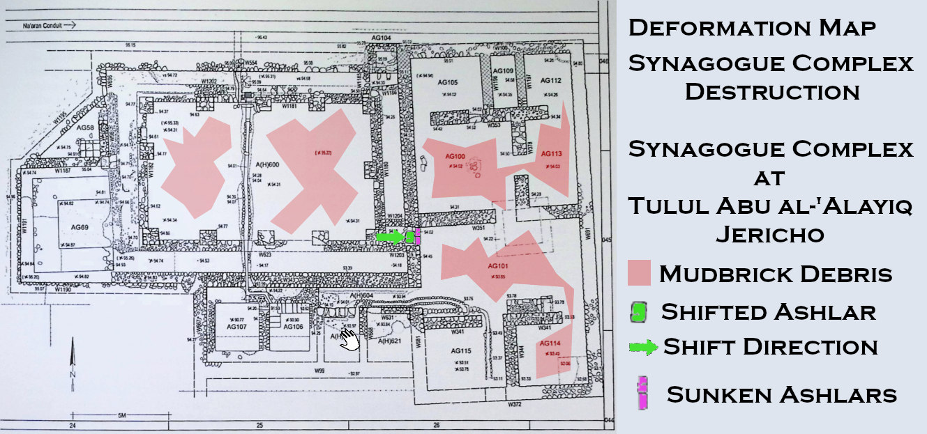
the top ashlar probably served as the third step, which had
shifted eastward during the earthquake that destroyed the
building in 31 B.C.E. The two bottom steps probably sank during
the same process.
14. The western end of this wall was demolished during the construction
of the triclinium, and was replaced by a new wall built slightly to its south.
15. Since the bottom two steps were found sunken at the time of excavation,
we were initially of the opinion that the large, top ashlar here was placed
above the sunken steps already in antiquity. However, our recent study
showed that the top ashlar probably served as the third step, which had shifted
eastward during the earthquake that destroyed the building in 31 B.C.E.
The two bottom steps probably sank during the same process.
16. This landing must have been at a level of ca. +94.60.
17. As will be discussed in the summary, the pillared hall
apparently had a basilical section (with the roofs of the aisles
lower than that of the nave).
18. Thus, the space between the pillars and the aisles' rear
walls was widest on the west (1.75 m) and narrowest on the east
(1.35 m).
19. We are of the opinion that descent into the hall was
generally via the benches themselves (which were only 45 cm
high), and that the step under discussion was inserted in the
third phase. The proximity of the kitchen apparently dictated
its location here.
20. Their upper parts were tentatively constructed of mud
bricks.
21. During our excavations in 1987–1988, a part of the
southern side of the hall was exposed. Since only some of the
pillars here were unearthed, and no plaster was preserved on
them, we were of the opinion that a low wall between them
basically separated the nave from the aisle. Only during the
excavations of 1997–1998 did we expose the rest of the hall and
find plaster preserved in situ on the other pillars. Hence, we
understood that the aisles must have had a higher floor level
(evidence of which was later also found) and, after the
unearthing of the special niche, the channel, the triclinium,
and the ritual bath, the picture of a synagogue with its
elevated aisles slowly emerged.
22. These walls were of varying width: W1181 on the north —
63 cm; W1180 on the east — 55 cm; W623 on the south — 53 cm; and
W1182 on the west — 50 cm.
23. Near the (missing) southeastern corner of the kitchen here,
and partly below it, three flat ashlars, one long and two short,
were found (see Ill. 184). The long one on the west was located
within the confines of the demolished wall, whereas the two
shorter ones were sunk into the pebble-strip, their tops being
located a few centimeters below the floor level here. Although
their function is unclear, we assume that they belong to the
last stage of the hall, especially since the large ashlar is
located below the corner of the kitchen, within the limits of
the earlier wall.
24. Moreover, the water channel, crossing the northern aisle
from north to south, ran some 20 cm above virgin soil here
(which was leveled in this area), and ca. 15 cm above the
wall/bench (W1202; the "second" bench) to the north of the front
bench (W1181). This means that if only a beaten-earth floor (and
no additional benches) had existed here, both the channel and
W1202 would have projected above it. Moreover, the good
preservation of the channel here implies that the floor also
should have survived, especially since this was the best
preserved part of the hall.
25. The bottom part of the niche was dug into virgin soil.
26. Because of the plaster preserved on the walls of the niche,
we were able to establish its two phases; the walls of the
second phase were built abutting this plaster on the west and
north.
27. In theory, the change in the niche could have been
implemented at the same time as the addition of the triclinium
to the hall. However, the remains of ash noted on the lower
compartment's floor (below the east-west partition wall and
upright stones) suggest a local catastrophe which might have led
to the changes in the niche.
28. The reason why the wall was not widened on the east is
unknown. In our opinion, the widening on the west thus appears
to be superfluous.
29. This wall was 50 cm wide in its bottom part, and from the
level of the upper compartment, its width decreased to 30 cm.
30. "Entry" should be understood here rather figuratively. In
order to insert scrolls into the lower compartment, one had to
kneel on the ground and push them inside manually.
31. The inner structure of the niche was reconstructed from the
pieces that lay collapsed inside.
32. The walls in the lower compartment were also plastered (and
technically, this could have been done only prior to the
construction of the floor of the upper compartment).
33. See note 27.
34. This plank "protected" the access to the lower compartment,
and at the same time provided free access to the upper one.
35. The steep slope (preserved to a height of 35 cm) of the
channel here was dictated by the higher level of the Nacaran
Conduit, which supplied water to it.
36. As a matter of fact, this second slope also extended to the
east, against the southern face of the basin's southern rim, up
to the pillar to the east of the latter.
37. The channel below the hall's floor conveyed water, which
evidently had to remain ritually pure, to the ritual bath on the
south.
38. Moreover, if no benches had existed here, the channel would
have projected above the floor, and since the channel descending
from wall W554 was an open one, the area around it would have
been mostly wet.
39. If the triclinium had been located along the building's
longitudinal axis, it would have been impossible to remove the
pillar.
40. As explained in the description of the hall, the "higher,"
western bench [which originally formed a corner with the second
bench (W1120) in the northern aisle] was demolished when the
kitchen and the triclinium were added to the hall. It seems that
simultaneously, the western end of the benches in the northern
aisle was also destroyed. Hence, the northwestern corner of the
hall provided some more space for the traffic around the
kitchen's entrance, and anyhow, not much of the hall was visible
from the benches in this corner.
41. As a matter of fact, in order to add the room to the hall,
virgin soil had to be removed from this area.
42. On the east, the front end of the couches was more or less
in alignment with the former western wall of the hall here.
43. As a matter of fact, in order to add the room to the hall, virgin soil had to be removed from this area.
44. On the east, the front end of the couches was more or less in alignment with the former western wall of the hall here.
 Tulul Abu al-'Alayiq


 Deformation Map
