Khirbet Tannur
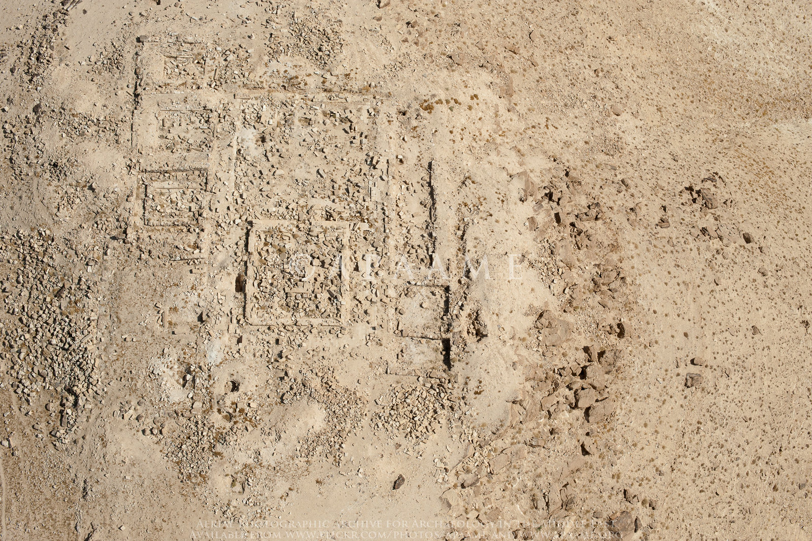
APAAME
- Reference: APAAME_20141019_DLK-0146.jpg
- Photographer: ?
- Credit: Aerial Photographic Archive for Archaeology in the Middle East
- Copyright: Creative Commons Attribution-Noncommercial-No Derivative Works
Click on Image for high resolution magnifiable image
| Transliterated Name | Source | Name |
|---|---|---|
| Khirbet et-Tannur | Arabic | خربة التنور |
- Russian Nesting Dolls
 Russian Nesting Dolls (aka Matryoshka dolls)
© BrokenSphere / Wikimedia Commons
is close to the King's Highway and is 7 km (4 mi.) north of another temple, Khirbet edh-Dharih, in Wadi La'ban(Marie-Jeanne Roche in Meyers et. al., 1997). Khirbet edh-Dharih is apparently architecturally and stylistically similar to Khirbet Tannur but is better dated which can help sort Khirbet Tannur chronology.
- Fig. 2 - Location Map
from Whiting and Wellman (2016)
 Figure 2
Map showing the location of Khirbet et-Tannur, other Nabataean sites, and the King’s Highway
Whiting and Wellman (2016) - Location Map from Meyers et al (1997)
 Wadi el-Hasa
Map of Wadi el-Hasa Archaeological Survey territory
(Courtesy B. MacDonald
Meyers et al (1997)
- Fig. 2 - Location Map
from Whiting and Wellman (2016)
Figure 2
Map showing the location of Khirbet et-Tannur, other Nabataean sites, and the King’s Highway
Whiting and Wellman (2016) - Location Map from Meyers et al (1997)
Wadi el-Hasa
Map of Wadi el-Hasa Archaeological Survey territory
(Courtesy B. MacDonald
Meyers et al (1997)
- Khirbet Tannur in Google Earth
 Khirbet Tannur in Google Earth
click on image to explore this site on a new tab in Google Earth
- Fig. 1 - Plan of Khirbet
Tannur from Meyers et. al. (1997)
 Figure 1
Plan of the site
Courtesy ASOR/Nelson Glueck Archive—Semitic Museum, Harvard University
Meyers et. al. (1997) - Fig. 6.4 - Plan of Khirbet
Tannur from McKenzie et al (2013)
 Fig 6.4
Khirbet et-Tannur, plan with the terms used here for the parts of the site, and their equivalents in Glueck's journal
Mckenzie et al (2013) - Fig. 1 - Axonometric reconstruction
of Khirbet Tannur from Whiting and Wellman (2016)
 Figure 1
Khirbet et-Tannur, axonometric reconstruction
(Sheila Gibson)
Whiting and Wellman (2016) - Fig. 54 - Axonometric reconstruction
of Inner Temple of Khirbet Tannur from Whiting and Wellman (2016)
 Figure 54
Khirbet et-Tannur, reconstruction of Inner Temenos Enclosure and Altar Platform
(Sheila Gibson)
Whiting and Wellman (2016)
- Fig. 1 - Plan of Khirbet
Tannur from Meyers et. al. (1997)
Figure 1
Plan of the site
Courtesy ASOR/Nelson Glueck Archive—Semitic Museum, Harvard University
Meyers et. al. (1997) - Fig. 6.4 - Plan of Khirbet
Tannur from McKenzie et al (2013)
Fig 6.4
Khirbet et-Tannur, plan with the terms used here for the parts of the site, and their equivalents in Glueck's journal
Mckenzie et al (2013) - Fig. 1 - Axonometric reconstruction
of Khirbet Tannur from Whiting and Wellman (2016)
Figure 1
Khirbet et-Tannur, axonometric reconstruction
(Sheila Gibson)
Whiting and Wellman (2016) - Fig. 54 - Axonometric reconstruction
of Inner Temple of Khirbet Tannur from Whiting and Wellman (2016)
Figure 54
Khirbet et-Tannur, reconstruction of Inner Temenos Enclosure and Altar Platform
(Sheila Gibson)
Whiting and Wellman (2016)
- Plate 112a - Inclined Wall
from Glueck (1965)
 Plate 112a
Sub-II pavement laid against base of north side of Altar-Pedestal of Period I
Glueck (1965)
| Effect | Location | Image(s) | Description |
|---|---|---|---|
|
Period I Altar
Fig 6.4 Khirbet et-Tannur, plan with the terms used here for the parts of the site, and their equivalents in Glueck's journal Mckenzie et al (2013)
Figure 1Khirbet et-Tannur, axonometric reconstruction (Sheila Gibson) Whiting and Wellman (2016)
Figure 54Khirbet et-Tannur, reconstruction of Inner Temenos Enclosure and Altar Platform (Sheila Gibson) Whiting and Wellman (2016) |
Plate 112a Sub-II pavement laid against base of north side of Altar-Pedestal of Period I Glueck (1965) |
|
| Effect | Location | Image(s) | Description |
|---|---|---|---|
|
ornate pylon of the east facade of the raised inner temple enclosure
Fig 6.4 Khirbet et-Tannur, plan with the terms used here for the parts of the site, and their equivalents in Glueck's journal Mckenzie et al (2013)
Figure 1Khirbet et-Tannur, axonometric reconstruction (Sheila Gibson) Whiting and Wellman (2016)
Figure 54Khirbet et-Tannur, reconstruction of Inner Temenos Enclosure and Altar Platform (Sheila Gibson) Whiting and Wellman (2016) |
|
|
|
Period II altar near the northeast corner of the forecourt
Fig 6.4 Khirbet et-Tannur, plan with the terms used here for the parts of the site, and their equivalents in Glueck's journal Mckenzie et al (2013)
Figure 1Khirbet et-Tannur, axonometric reconstruction (Sheila Gibson) Whiting and Wellman (2016)
Figure 54Khirbet et-Tannur, reconstruction of Inner Temenos Enclosure and Altar Platform (Sheila Gibson) Whiting and Wellman (2016) |
|
| Effect | Location | Image(s) | Description |
|---|---|---|---|
|
colonnades of the Court
Fig 6.4 Khirbet et-Tannur, plan with the terms used here for the parts of the site, and their equivalents in Glueck's journal Mckenzie et al (2013)
Figure 1Khirbet et-Tannur, axonometric reconstruction (Sheila Gibson) Whiting and Wellman (2016)
Figure 54Khirbet et-Tannur, reconstruction of Inner Temenos Enclosure and Altar Platform (Sheila Gibson) Whiting and Wellman (2016) |
|
| Effect | Location | Image(s) | Description |
|---|---|---|---|
|
various locations
Fig 6.4 Khirbet et-Tannur, plan with the terms used here for the parts of the site, and their equivalents in Glueck's journal Mckenzie et al (2013)
Figure 1Khirbet et-Tannur, axonometric reconstruction (Sheila Gibson) Whiting and Wellman (2016)
Figure 54Khirbet et-Tannur, reconstruction of Inner Temenos Enclosure and Altar Platform (Sheila Gibson) Whiting and Wellman (2016) |
|
- Modified by JW from Fig. 6.4 of McKenzie et al (2013)
 Deformation Map
Modified by JW from Fig. 6.4 of McKenzie et al (2013)
- Modified by JW from Fig. 6.4 of McKenzie et al (2013)
 Deformation Map
Modified by JW from Fig. 6.4 of McKenzie et al (2013)
- Modified by JW from Fig. 6.4 of McKenzie et al (2013)
 Deformation Map
Modified by JW from Fig. 6.4 of McKenzie et al (2013)
- Modified by JW from Fig. 6.4 of McKenzie et al (2013)
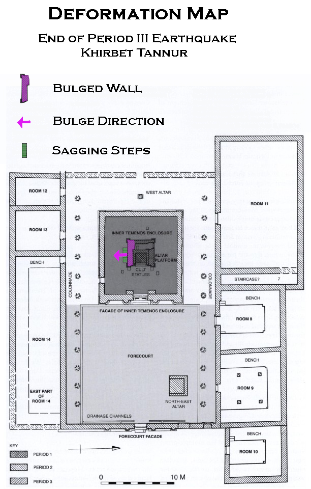 Deformation Map
Modified by JW from Fig. 6.4 of McKenzie et al (2013)
-
Earthquake Archeological Effects chart
of Rodríguez-Pascua et al (2013: 221-224)
 Earthquake Archeological Effects (EAE)
Rodríguez-Pascua et al (2013: 221-224)
| Effect | Location | Image(s) | Description | Intensity |
|---|---|---|---|---|
|
Period I Altar
Fig 6.4 Khirbet et-Tannur, plan with the terms used here for the parts of the site, and their equivalents in Glueck's journal Mckenzie et al (2013)
Figure 1Khirbet et-Tannur, axonometric reconstruction (Sheila Gibson) Whiting and Wellman (2016)
Figure 54Khirbet et-Tannur, reconstruction of Inner Temenos Enclosure and Altar Platform (Sheila Gibson) Whiting and Wellman (2016) |
Plate 112a Sub-II pavement laid against base of north side of Altar-Pedestal of Period I Glueck (1965) |
|
|
-
Earthquake Archeological Effects chart
of Rodríguez-Pascua et al (2013: 221-224)
Earthquake Archeological Effects (EAE)
Rodríguez-Pascua et al (2013: 221-224)
| Effect | Location | Image(s) | Description | Intensity |
|---|---|---|---|---|
|
ornate pylon of the east facade of the raised inner temple enclosure
Fig 6.4 Khirbet et-Tannur, plan with the terms used here for the parts of the site, and their equivalents in Glueck's journal Mckenzie et al (2013)
Figure 1Khirbet et-Tannur, axonometric reconstruction (Sheila Gibson) Whiting and Wellman (2016)
Figure 54Khirbet et-Tannur, reconstruction of Inner Temenos Enclosure and Altar Platform (Sheila Gibson) Whiting and Wellman (2016) |
|
|
|
|
Period II altar near the northeast corner of the forecourt
Fig 6.4 Khirbet et-Tannur, plan with the terms used here for the parts of the site, and their equivalents in Glueck's journal Mckenzie et al (2013)
Figure 1Khirbet et-Tannur, axonometric reconstruction (Sheila Gibson) Whiting and Wellman (2016)
Figure 54Khirbet et-Tannur, reconstruction of Inner Temenos Enclosure and Altar Platform (Sheila Gibson) Whiting and Wellman (2016) |
|
|
aesthetically attractive but architecturally weaknoting shoddy internal construction particularly the bottom foundation stones (Glueck, 1965:107). Glueck (1965:106) was also unsure that an earthquake damaged Period II structures stating that
earthquake tremors or age or both may have brought about the collapseof the Period II Altar-Base. Considering this, the Intensity estimate is downgraded to VI-VII (6-7).
-
Earthquake Archeological Effects chart
of Rodríguez-Pascua et al (2013: 221-224)
Earthquake Archeological Effects (EAE)
Rodríguez-Pascua et al (2013: 221-224)
| Effect | Location | Image(s) | Description | Intensity |
|---|---|---|---|---|
|
colonnades of the Court
Fig 6.4 Khirbet et-Tannur, plan with the terms used here for the parts of the site, and their equivalents in Glueck's journal Mckenzie et al (2013)
Figure 1Khirbet et-Tannur, axonometric reconstruction (Sheila Gibson) Whiting and Wellman (2016)
Figure 54Khirbet et-Tannur, reconstruction of Inner Temenos Enclosure and Altar Platform (Sheila Gibson) Whiting and Wellman (2016) |
|
|
-
Earthquake Archeological Effects chart
of Rodríguez-Pascua et al (2013: 221-224)
Earthquake Archeological Effects (EAE)
Rodríguez-Pascua et al (2013: 221-224)
| Effect | Location | Image(s) | Description | Intensity |
|---|---|---|---|---|
|
various locations
Fig 6.4 Khirbet et-Tannur, plan with the terms used here for the parts of the site, and their equivalents in Glueck's journal Mckenzie et al (2013)
Figure 1Khirbet et-Tannur, axonometric reconstruction (Sheila Gibson) Whiting and Wellman (2016)
Figure 54Khirbet et-Tannur, reconstruction of Inner Temenos Enclosure and Altar Platform (Sheila Gibson) Whiting and Wellman (2016) |
|
|