Location Map from Ambraseys and Karcz (1992)

Fig. 1. Location map of the earthquake of 14 January 1546. Solid circles show sites where the shock was
reported felt or caused damage. Large open circles indicnte other localities mentioned in the text.
Small open circles show some other places where reported damage my not be associated with the
1546 earthquake. Shading shows estimated extent of epicentral region. Arrows show extent of coast
affected by the associated seismic sea-wave.
Ambraseys and Karcz (1992)
AD 1546 Jan 14 The Holy Land
The earthquake of 1546 in the Holy Land is considered
to be one of the most important shocks known to have
occurred in the Middle East to which modern writers
assign a magnitude M
L 7.0 and an epicentral intensity of
X-XI (Ben Menahem 1979). However, the available evidence
suggests that this was not a major earthquake and
it must be classed as one of those which excite widespread
interest rather on account of the geographical location
than because of their special violence.
This event is presented in some detail not only
because it is imperfectly known and its effects are usually
grossly exaggerated, but also because it occurred in what
appears today to be a seismically quiescent region of a
densely populated and fast-developing part of the Middle
East.
Early catalogues ignore the 1546 earthquake.
Bonito (1691) gives, without details, an earthquake in
Judaea in 1541, and the event is mentioned briefly by
Hoff (1840) on the authority of Bernherz (1616), whose
primary source is Rivander Bachmann (1607), itself a
secondary source. Perrey (1850) follows Hoff (1840)
and Mallet (1852) quotes Rivander Bachmann. Schmidt
(1879) notes the earthquake briefly and quotes Anonymous
of Wittenberg (1546), a primary source. Arvanitakis
(1903b), on the authority of Dositheos (1715), dates
the event to 1543, and Willis (1928) copies the earthquakes
of 1534 and 1546 from Arvanitakis (1903b) and
Perrey (1849), respectively, thus duplicating the event.
Sieberg (1932a; 1932b) and later authors, with the exception
of Braslayski (1938), who should be given credit
for using a number of original sources, add nothing but
confusion. Finally, Ben Menahem (1979) and Rotstein
(1987), who do not give their sources of primary information,
regard this event, with little justification, as one
of the most destructive in the Jordan rift zone.
The information on the effects of the earthquake
of 1546 retrieved so far comes from both occidental and
oriental sources. Among these is the account of an anonymous Venetian, who was probably an eye-witness. Other
contemporary or near-contemporary sources include the
continuator of Mujir al-Din’s history, as well as Hebrew,
Greek and Turkish material and the accounts left by
travellers. The event may be reconstructed using these
accounts as the foundation. Other late -sixteenth- and
seventeenth-century sources that preserve information
on the 1546 earthquake that are considered as original are
also taken into account. The earthquake of 1546 occurred
only 30 years after the Ottoman conquest of Syria and
Egypt (1516–17), as a result of which Palestine became a
province of the Ottoman Empire. This undoubtedly had
an effect on the production of local dynastic chronicles
in Arabic, both in Egypt and in Syria. The sources of
local information for this period are, therefore, chiefly
in Hebrew and Turkish, mainly private and state correspondence, as well as archival material from local
Sharia courts and, to a lesser extent, the accounts left
by travellers. The correspondence from Cyprus and Constantinople in the archives of Venice containing news
from Palestine was also examined, as were Greek church
sources originating from Jerusalem.
The earliest information about the 1546 earthquake comes from a letter written to a nobleman in
Venice and published the same year in Wittenberg. The
original letter was written in Italian, probably originating
from a town on the coast of Palestine. It says that
About
noon, on the 14th of January AD 1546 there was a terrific earthquake in Jerusalem. As a result the vault of the
Holy Tomb sunk and the walls and tower of the Temple
were damaged and parts of them collapsed. The same happened in Damascus and great damage was done to other
towns and villages; many people perished at sea and on
land. Four towns in particular, Rama, Joppe, ‘Zozilgip
and Sichem were totally destroyed by this earthquake to
the extent that, with the exception of Damascus and Joppe,
one can no longer recognise that there had been towns on
these sites. And there exist no other places in these regions
that would not have been damaged. On the same day,
blood was flowing out from a fountain, named after the
Prophet Eliseo, from which always water was drawn off.
And at the beginning of this, flames coming out from the
fountain were seen, and this lasted for four days. On the
day of the earthquake the river Jordan dried up for two
days and so did all the streams around Joppe that fall into
the sea, which stopped flowing for three days. And when
they began to flow again, the water was red. The sea near
Joppe retreated to a distance of a full days’ walk off shore
(sic.), so that one could walk with dry feet on the sea bed. A
great many people, about 10 000, who ventured on foot offshore were drowned when the sea came back. At the same
time, unusually strong winds got up so that near Tripoli
they brought up a lot of sand and clay from the south that
drifted into mounts. At the same time, equally strong winds
caused great damage to the city of Famagusta in Cyprus
and ruined its vineyards, something that also happened at
San Sergio’ (Anon. 1546).
Figure 3.20 News from Wittemberg about the earthquake of 14 January 1546 in Palestine

Figure 3.20 News from Wittemberg about the earthquake of 14
January 1546 in Palestine and strong winds that caused great
damage to the city of Famagusta in Cyprus. JW: Original Image from Ambraseys (2009) has been replaced
with an image from an online digital copy of the manuscript.
The original letter in Italian seems to have
been the basic source of information for a number of
contemporary flysheets in Europe that spread the news
of the earthquake in Jerusalem of Thursday noon, 14 January 1546, Anonymous (1546; 1693), Bonito (1691), Hellmann (1912), Perrey (1863) and Beinert (1955). Such a
wide circulation reflects obviously the desire to draw theological morals from a natural disaster, particularly since
the earthquake occurred in the Holy Land; Fincelius
(1556) and Rivander Bachmann (1607). However, in the
process of translation and printing of the original letter
some of the details, particularly place names, were either
omitted or suffered changes that today are difficult to rectify. Klein (1939) suggests that Zozilgip, one of the four
destroyed towns mentioned in the German version of the
Venetian letter Figure 3.20, stands for zoz ilgip, that is, so
ist al-Gib, al-Gib being the early Giv’on, a township north
of Jerusalem.
However, confirmation of this identification must
await the retrieval of the original Italian version of the
Venetian letter. The French version does not mention
Zozilgip at all, and differs in some details from the German version. It attributes to a tempest the collapse of part
of the walls of the Sepulchre in Jerusalem, of one third of
the temple of Solomon, i.e. one of the mosques on Temple Mount, and of all the bell towers in Judea; in addition
it implies that the coast was flooded by the sea all the way
from Gaza to Jaffa (Techener 1861). The number of people drowned by the seismic sea wave is, obviously, grossly
exaggerated.
More striking differences in location and on the
date of damage have led to a controversy over the
provenance of a sixteenth-century Spanish manuscript
that describes the same event. This document, annotated as News of ‘46’, and obviously a contemporary copy
from an unknown original, is indeed very similar in content to the Wittenberg version. However, it places the
earthquake on 8 January 1546, does not mention Zozilgip and Sichem, and reports instead the destruction of
Cifayde and Cigle. It also says that the whole province
of Damascus was affected but that the city itself, and yet
another city, did not suffer any damage. Beinert (1955
and personal communication 1991), who has read the
manuscript, believes that these differences, as well as
the phrasing, indicate that this is a first-hand account
of the earthquake, experienced by a Spanish monk or
pilgrim. He suggests that Cifayde stands for Safed in
Galilee, a town not mentioned in the other versions.
On the other hand, Braslavski (1956) and Shalem (1955)
assume that this document is no more than a somewhat
careless translation of the German or French versions,
with errors in copying the transliteration of geographical
names; Shalem argues that Cigle stands for Sichem, i.e.
Nablus in Samaria, and Braslavski identifies Cifayde as
Jaffa. An obviously independent contemporary account
of the earthquake is found in the anonymous continuator
of the chronicle by Mujir al-Din, in Mayer (1931). Though
this sequel (dhail) covers events that took place between
1497 and 1509, that is before Mujir al-Din’s death in a.H.
927 (1521), it begins with the description of three earthquakes that followed one another during the period a.H.
952–953 (AD 1546). The part of this chronicle that refers
to this sequence says that
On Thursday afternoon, 10th
of Dhu’l-Qa’da 952, there occurred a great earthquake
in Jerusalem, al-Khalil [Hebron], Gaza, al-Ramlah, alKarak, as-Salt, and Nablus which extended to Damascus.
It lasted a short while and calmed down, and generally
there was not a tall house in Jerusalem that was not left
destroyed or fissured, and the same in al-Khalil [Hebron].
In Gaza the madrasa of Qayitbey was destroyed as well as
the south part of his madrasa in Jerusalem, and its north
and east sides; also, the top of the minaret over the Bab
as-Silsila was destroyed. In Nablus the earthquake was
stronger than elsewhere, and 500 lives were lost under the
ruins.
Then, on Sunday night, 10th of Muharram, 953
[= 13 March 1546] there was another alarm, the noise of
which was greater before it died out.
Then, on Wednesday afternoon, 12th Rabi’ I of the
year 953 [= 13 May 1546], there occurred another shock
felt by some people more than others, apart from the continuous shocks of previous days, some of which occurred
at night and some during the day . . .
Although many of the details in the sequel to
Mujir al-Din’s chronicle resemble those in the Venetian
letter, which refers quite clearly to the 1546 earthquake,
their inclusion at the beginning of a historical account
that describes events that belong to the period 902–914
(AD 1497–1509) raised some doubt regarding the actual
year of these events. Mayer recognised that this complication might be due to a mere slip of the pen of a
scribe, who, whilst turning marginal notes into the sequel
of Mujir al-Din’s chronicle, copied later events first and
a series of earlier events, running consecutively, later
(Mayer 1931).
However, Mayer was more inclined to think that
what he had in his hands was a faithful copy of the dhail
as written by Mujir al-Din himself, and that the events
described are in the right chronological order, that is, that
there was an error in the years, which should read 902
and 903 rather than 952 and 953. However, another reason why Mayer was more inclined to think that there was
an error in the years of these events was that he could find
no evidence for an earthquake in either Syria or Palestine
in the year a.H. 952 (1546). Obviously, he was not aware
of the Venetian letter and of the other sources which
we have retrieved that now remove any ambiguity about
the actual date of the event. The incorrect year given by
Mayer was thus propagated in later catalogues. Reading
the years of the earthquake sequence in Mujir’s dhail as
a.H. 952 and 953, the date of the main shock, Thursday 10
Dhu’l Qa’da 952, corresponds to 13 January 1546, which
was a Wednesday. A discrepancy of one day is common
in converting the Muslim calendar. For instance, a sigil
in the Khaladiyye Library in Jerusalem (1856, vol. 17,
437), dated 21 Dhu’l-Qa’da a.H. 952, says briefly
the day
before today, Thursday the 10th of the month, after the
noon prayer, a disaster came from the sky and a great
earthquake occurred in the name of God.
For the date of the second shock Mayer considers Mujir al-Din’s date to be the ‘night of 11 Muharram’,
which would have been Sunday 14 March, although the
Arabic text says ‘Sunday night 10 Muharram’ 953, which
corresponds to Saturday 13 March 1546. This is correct
since Sunday night in the Muslim calendar means the
night starting on Saturday, since the Muslim day starts at
sunset and day follows night. However, the Khaladiyye
manuscript of the dhail gives 13 Dhu’l-Qa’da, that is,
three days after the main shock. For the third shock in
Mujir’s sequel, Wednesday afternoon 12 Rabi I 953 corresponds to 13 May, which was a Thursday. There can thus
be little doubt that the details in Mujir’s chronicle refer to
the earthquake sequence of 1546, and that the dhail must
have been added by a later scribe or by a copyist. Indeed,
Mayer himself says that in the copy of the dhail kept in
the Khaladiyye Library, which has not been viewed, the
earthquakes are described in an additional note on the
last page.
Contemporary Hebrew documents provide an
additional, independent source of information about the
earthquake. A Hebrew manuscript notice written by
Sussman ben Rabbi Abraham Carit, who arrived in
Jerusalem in 1545 two months before the earthquake,
states that
in the month of Shvat the Almighty has shown
us signs and wonders that none of our forefathers ever
witnessed, and on the 11th of that month, on Thursday,
about one in the afternoon . . . [because] of the quake many
towers fell down, almost the third of their height, and the
tower of “A. A.” was one of them. About ten gentiles were
killed in Jerusalem but none of the Jews, and in the town
of Nablus the earthquake was so strong that at least three
hundred gentiles, and three or four Jews were killed. There
were also further shocks after that, but not so strong, and
to this day we are in constant fear of an earthquake all day
and night (Braslavski 1938).
The 11th of Shvat corresponds to 14 January 1546,
which was a Thursday. Klein (1939) suggests that ‘A. A.’
stands for ‘Avraham Avinu’, i.e. our Father Abraham,
and refers to the tower over Abraham’s Tomb in Hebron.
This locality is mentioned in Mujir al-Din’s sequel as
al-Khalil, the Arabic name used for Hebron because of
Abraham’s sanctuary, the Friend of Allah. The disagreement as to when the copy of this document was made
and by whom (Braslavski 1938; Turnianski 1984) does
not detract from the authenticity of its contents. Sussman died about 20 years after the earthquake, and the
phrasing suggests that he wrote the note shortly after the
event.
A more detailed description of the effects of the
earthquake, about 18 lines long, is found in a copy of
another Hebrew document, appended to a booklet called
Ot nafshi, in 1625, or in 1562, according to Klein (1939),
belonging to one Isaac Levy, and apparently copied by
him from an unknown source. According to this document,
On Thursday 11th, of the month Shevat, year
Hashav [14 January 1541], at one in the afternoon, there
was a great earthquake and there was almost total destruction of Jerusalem, there is no house that was not destroyed
or cracked, and even from the new city wall there fell a
scythe in height, such as at the Gate of Mercy. And also
fell the Ishmaelite mosques as well as the cupola of alAqsa, and so did the Holy Sepulchre, a building full of
windows, that some say was built by Nabuchadnezar king
of Babylon and even the Ishmaelites are wondering since it
was a very strong building. And the gentiles say that there
never was such an earthquake in Jerusalem . . . and in contrast, praise be to God, our synagogue was left undamaged.
About 12 Ishmaelites perished, and none of the Jews. But
in Nablus about 560 Ishmaelites perished of the townfolk,
but nobody knows of the villagers, since they still may be
buried under the rubble; three Jews died in Nablus. And in
Hebron, 16 Ishmaelites perished and 70 were injured with
broken arms and legs. And the gentiles report that the river
Jordan is dry and they crossed it on dry land and that this
lasted three days. Worse than the fall of their houses, they
lamented their [loss of] water, . . . which turned into blood
for three or four days. And . . . the Jordan was dry and desolate because two big hills fell into the river, and others
say that the earth cracked and swallowed up the waters
of the Jordan. It is also said that the gentiles in Jerusalem
offered monies to the Ishmaelites to allow them to rebuild
a church, but to no avail, and what fell, remained fallen.
There is no house in Jerusalem that did not crack in the
earthquake, and also, many mosques have collapsed . . .
(Braslavski 1939).
The words
but nobody knows how many of the
villagers [perished] since they still may be buried
suggest that this document was written immediately after
the event. However, the penultimate sentence, regarding the refusal of the Ottoman authorities to approve the
reconstruction of churches, implies that this document
was not composed so soon after the earthquake. Internal
evidence suggests that this notice was written sometime
after the event.
A contemporary Hebrew ode, ‘piut’, composed by
a certain Moshe Meali, and found in the Cairo Geniza
by Razabi (1982), describes a plague, earthquake, famine
and locust infestation that befell Jerusalem. The earthquake, it says, caused houses and shops to collapse.
Two synagogues fell apart and so did two churches that
adjoined each other. Severe damage was caused to the
Holy Sepulchre and to the Dome of the Rock. The people left their houses and stayed in the city cemeteries.
This poem, which was composed some time after
these calamities, extends their occurrence over several
years, starting with AD 1542/3 (‘hashab’). The earthquake is placed in the midst of a Passover feast of the
following year, that is, sometime in the spring of 1543 or
1544. It would appear that the poet, who was writing some
time after these events, erred in the year, and that the
association of the earthquake with the Passover is purely
decorative.
Additional information about the effects of the
earthquake can be gleaned from the narrative of European travellers who happened to be in the Holy Land
shortly after the 1546 earthquake. Anonymous of Douai
(1714), most probably a Franciscan friar, left France in
October 1545. The copy of his narrative made in 1714 is
incomplete and starts in the middle of a phrase describing the Holy Sepulchre in Jerusalem, concerning which
he does not mention any earthquake damage. From
Jerusalem he proceeds to Bethlehem, then Ramla, and
he is in Jaffa on 7 June 1546, from where he sails off
to Cyprus and Venice, where he arrives on 29 August.
Therefore, he should have arrived in the Holy Land a few
months after the earthquake and probably would have
experienced the aftershock of 13 May 1546. However,
nowhere in the extant part of his narrative is there any
explicit mention of the effects of the 1546 earthquake.
His truncated account contains nothing about the effects
of the earthquake in Jerusalem. He travels to the Jordan river and the Dead Sea, and it is after leaving the
monastery of St Joachim that he describes (fol. 14r) a site
called ‘Donny’, previously a natural arch cut through rock
forming a bridge, which had been destroyed by earthquakes. From there he proceeds to the site of the ‘trois
montagnes’, which were dangerous on account of the
rocks that earthquakes cause to roll down from the summit, and arrives in Jericho, which he finds in ruins.
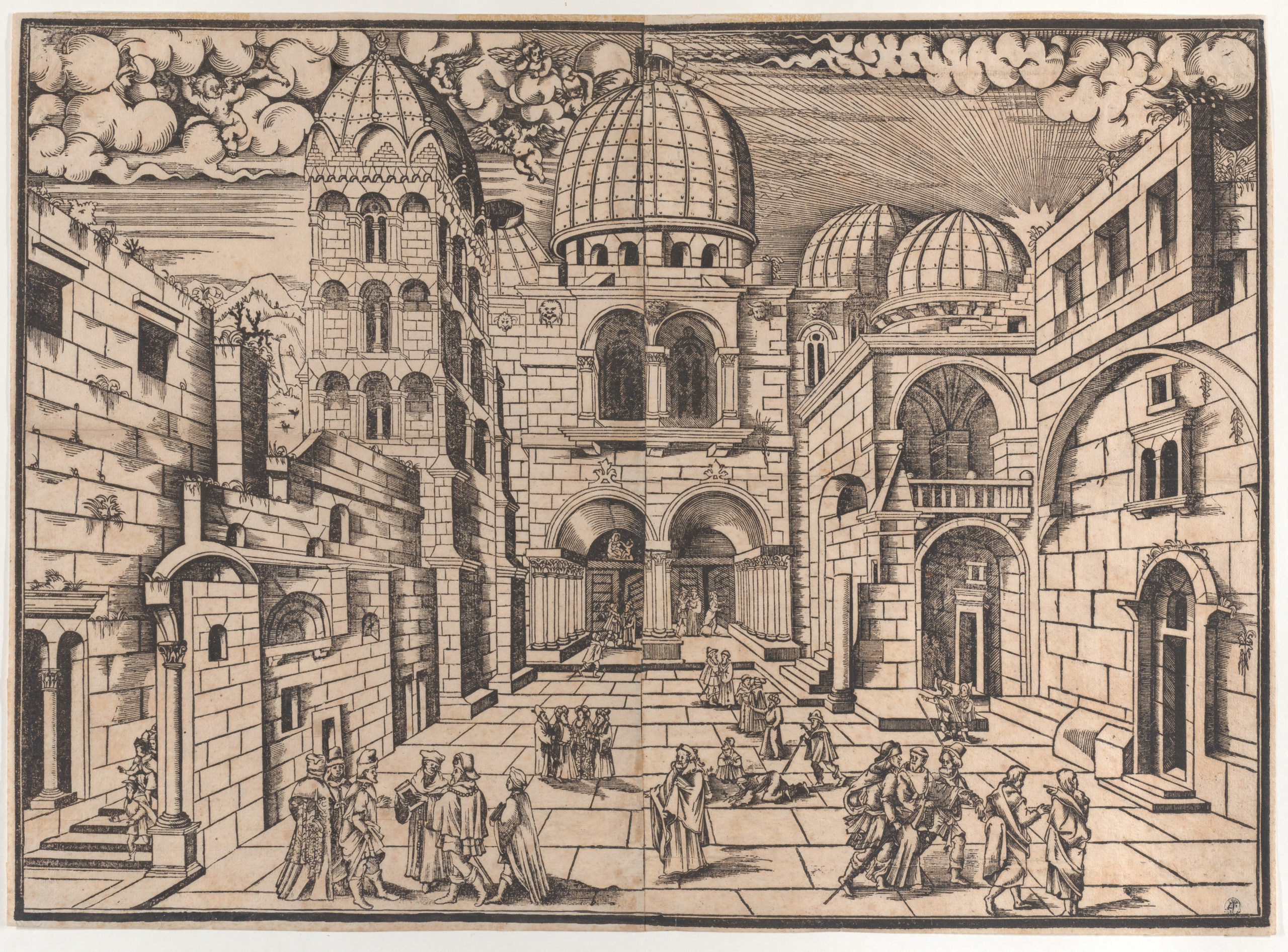
Figure 3.21 Voldrich's Jerusalem, drawn by Dominik de la Greche in the summer of 1546

Figure 3.21 Voldrich's Jerusalem, drawn by Dominik de la Greche in the summer of 1546, seen from the east. It shows the bell
tower of the Holy Sepulchre with its top part missing, with no other recognisable destruction caused by the 1546 earthquake
(Vit Karnik). Red arrow (added by Williams) points to the broken bell tower of the Holy Sepulchre
Figure 3.22 Drawing of the Church of the Holy Sepulchre before and after the earthquake of 1546
The narrative of Voldrich Prefat z Vlkanova,
an educated Czech pilgrim, contains more information
about the effects of the earthquake (Voldrich 1563). He
arrived in Jaffa via Corfu, Crete and Cyprus on 13 August
1546. In Jerusalem, the only damage he attributes to the
earthquake is that caused to the Holy Sepulchre, which
he describes as follows:
On the left side of the square,
as you face the door of the church, on the eastern side,
there is a tall square tower attached to the church built
of hewn stone, with many windows. As we were told, the
upper part of the tower collapsed during a strong earthquake that took place in Jerusalem just before the feast of
the Three Kings [Epiphany: 14 January]. The truss was
all vaulted up to the top and it was covered with sheets
of lead. However, it all collapsed together with a good
piece of the tower and still lies in ruins; nobody is repairing it.
In his detailed description of the Holy Sepulchre
and of its interior, Voldrich does not mention any other
earthquake damage. He appends a view of the church,
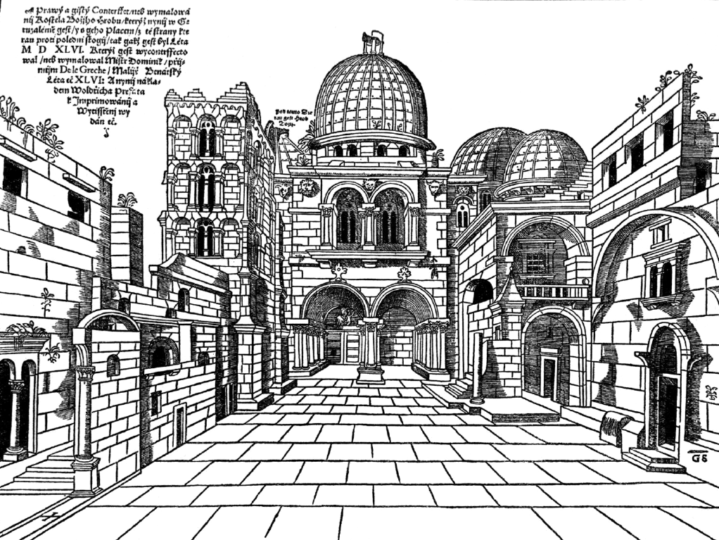
drawn by Dominik de la Greche shortly after the earthquake (see Figures 3.21–3.24) with the following caption:
This is the correct and true picture of the Church of the
Holy Sepulchre in Jerusalem, with its square, seen from
the south side, as it was in the year 1546, drawn by Master Dominik de le Greche, Venetian painter, in the year
46, and now printed under the care of Woldrich Prefat.
He also mentions the damage caused by the earthquake
in Bethlehem. After describing the basilica, he says that
in the same premises there used to be another vaulted and
relatively large church, but the earthquake, we were told,
destroyed it, so that its vault and base collapsed completely.
There are still a few pillars, pieces of the vault and walls
still to be seen, covered with debris. This was the church
of St Jeronymus. Several other adjoining buildings, cells, a
part of the refectory and the cloister were also badly damaged
He continues with the description of the monastery
and of other buildings in Bethlehem that survived the
earthquake without damage.
He notices other ruined buildings for which, however, he does not give the cause of their destruction. In
Ramla he notices several small chapels badly damaged
and says that parts of the town walls were always ruined.
On the way from Ramla to Jaffa he saw a church with the
upper part of its belfry destroyed. Near Ramla he found
the remains of a monastery that had also been destroyed.
On the road from Jerusalem to Bethlehem, on a hill,
there was a tower, the upper part of which was heavily
damaged. Near Bethlehem he saw a chapel that had collapsed completely; however, a church in a nearby field
was not damaged. Between Bethlehem and Bet Jala he
found another church that had collapsed, but its tower
was still standing. Near Battir, a small half-ruined town,
he found a chapel near a cave that had collapsed. On his
return from Bethlehem, near the place where John the
Baptist was born, he saw a church that was partly ruined,
as well as another church and a monastery nearby that
had suffered considerable damage. Also a square tower
and a few houses in Bethany were heavily damaged. On
the Olivet Mount he found the remains of a church and
a monastery, with some walls still standing. Jericho was
in ruins and the church, allegedly built by St Helen, damaged. On the way from the Dead Sea to Jericho, on a hill
on the left-hand side of the road, he saw another church,
which he says was that of St John the Baptist, which was
damaged. On travelling from Bethlehem to Hebron he
noticed another small church, a part of which had collapsed. Hebron and Jaffa, he says, were in ruins, but this
he attributes to the Egyptians and to the recent wars.
Figure 3.23 A view of the Church of the Holy Sepulchre and its square in the early part of the nineteenth century

Figure 3.23 A view of the Church of the Holy Sepulchre and its square in the early part of the nineteenth century. JW:
Ambraseys (2009) original image was replaced for a clearer image of the same artwork. Info about the drawing is available
here.
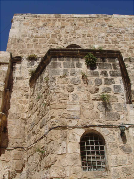
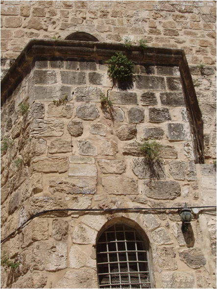
Fig. 3.24 - Photos of damage to the Church of the Holy Sepulchre due to a Dead Sea earthquake in 2004
Some details of the restoration of the Holy Sepulchre after the earthquake are given by Dositheos (1715),
Patriarch of Jerusalem (1641–1707), on the authority
of a contemporary Greek account written by Patriarch
Germanos II (1534–79). He says that
as a result of the
earthquake in the time of Germanos, the cupola of the
copper tower of the belfry of the Holy Sepulchre fell on
the nearby church of the Resurrection and caused the collapse of its dome that remains in ruins to the present day.
The same earthquake destroyed the bell-tower of the Saint
Bethlehem, its ruins left as seen today . . . these were the
only two belfries left standing by the Arabs that fell in this
earthquake.
The date of the event is not mentioned, but the
description of the damage sustained by the church of the
Resurrection bears a strong resemblance to that given for
the damage of the two churches adjoined to each other as
given in the Hebrew ‘piut’.
A very similar description is found in
Papadopulos-Kerameus (1898), who cites an anonymous Greek document, written in Jerusalem in the early
nineteenth century and deriving from earlier sources.
It says that
in the year 1545 (sic.) 14 January there was
a frightful earthquake in the Holy City and throughout
Palestine which caused the top of the beautiful bell-tower
of the church situated between those of Adelphotheou and
of St Tessarakonta to fall and destroy the dome of the
church; also in Bethlehem the earthquake destroyed the
bell-tower, the only one left standing by the Agarini [i.e.
the Arabs] (Papadopoulos-Kerameus 1898, iv. 40)
The
churches of Adelphotheou or Adelphopoeitou and of
St Tessarakonta were chapels in the compound of the
Holy Sepulchre next to the bell tower.
These accounts seem to be the source of information about the damage to the mediaeval bell towers
of the Holy Sepulchre and to the basilica in Bethlehem
mentioned by Vincent and Abel (1922) and Harvey and
Harvey (1938), who wrongly date the event to 1545.
Evidence for the repair of the damage caused
by the earthquake to various buildings can be found
in Ottoman archival sources. Some of those that have
been retrieved refer to repairs of public buildings, chiefly
Christian places of worship in Jerusalem. Although at
first the attitude of the local authorities was negative,
some repairs were eventually allowed, and gradually
more substantial construction work was permitted.
Thus, following a petition dated June 1548 made
by the Franciscans of Mt Zion in Jerusalem, permission
was granted first to restore several rooms and the damaged northern and eastern halls, and four months later
to repair six small rooms in the southern part of the
monastery (Cohen 1982).
The archives of the Custodia Terra Sancta in
Jerusalem contain numerous contemporary Ottoman
documents granting permission for the repair or strengthening of churches and convent property across the land
(Castellani 1922; Hussein et al. 1986). However, it is not
possible to say whether the damage that required repair
was due to the 1546 earthquake or to the war and natural ageing of these structures. These documents refer,
for example, to repairs of the walls of the convent in
al-Ramla, of the Church in Nazareth, on Mount Zion,
restoration of the cupolas and chapels of the Holy Sepulchre, and repairs of the terraces and cupola of the church
in Bethlehem. The decision to abandon a convent in
Nazareth in 1548 (Cirelli 1918) may have also been the
result of the 1546 earthquake.
The repair of buildings damaged by the earthquake apparently continued for almost a decade. An
order detailing repair work, issued in Istanbul and
addressed to the finance officer (defterdar) of Arabistan,
dated 17 Rabi II 959 (12 April 1552), says
the tombs
of Abraham the Friend (al-Khalil), Isaac and Jacob [at
Hebron] are situated in a mosque which has fallen down in
part and has become a ruin. Also the mosque that houses
the tomb of the Prophet Moses (Nabi Musa) is in need of
repair. And some parts of the wall which is situated on the
east side of the Dome of the Rock have been destroyed
by earthquakes so that a man can pass through; twice the
mosque’s lead has been stolen . . . The repair of all these
buildings is necessary and urgent (Heyd 1960).
Since this order was issued almost six years after
the earthquake, it may be only a supposition that it refers
to damage caused by the 1546 earthquake rather than,
perhaps, by later shocks. However, this is unlikely, since
delays in the Porte’s response to requests for repairs of
this nature were long. Moreover, this order refers to the
repair of structures that are known from other sources
to have been damaged by the 1546 earthquake and no
other shocks during the period 1547–52 have as yet been
identified.
Archaeological evidence and contemporary documents presented by Burgoyne (1987) also give further
indication of the damage to some of the Muslim buildings
in Jerusalem, such as the Ribat of ‘Ala’al-Din and Qayitbey’s madrasa (the Ashrafiyya). There is also evidence of
damage to the Aminiyya madrasa and the minaret of the
Fakhriyya.
The area strongly affected by the 1546 earthquake
was, therefore, confined within an area demarcated by
Nablus, Ar-Ramla and some point north of Jerusalem,
Nablus suffering more than the other sites, Figure 3.21.
However, it is rather surprising that despite the alleged
heavy damage caused in Nablus – the main centre of the
Samaritan community – no reference to this or to any
other sixteenth-century earthquake has been found, so
far, in the Samaritan chronicles and in the collections of
the AB Institute for Samaritan Studies.
Earthquake damage in Jaffa, except for the effects
of the seismic sea wave, is difficult to assess because
this and other coastal towns were, at that time, in
ruins and almost totally deserted (Rauwolff 1738; Schurr
1990). Voldrich Prefat z Vlkanova says that Jaffa ‘used
to be a clean town but now everything is in ruins
and no house can be seen; there are only two towers,
repaired to house the seat of the Turkish commander’
(Voldrich 1563).
Damage in Jerusalem, chiefly to tall structures,
was widespread but repairable and undoubtedly not
as serious as some of the contemporary exaggerated
accounts suggest. The description of Jerusalem left by
the pilgrims who visited the city shortly after the earthquake does not give the impression of a destructive earthquake. This impression is, to some extent, confirmed by
the detailed view of Jerusalem, drawn by Dominik de la
Greche a few months after the earthquake (Figure 3.23)
which shows no signs of destruction except for the top
of the bell tower of the Holy Sepulchre, which is missing
(Voldrich 1563).
In Bethlehem, the only structures that are known
to have been destroyed or damaged beyond repair were
the bell tower of the basilica, the church of St Jeronymous
and a few appended structures.
In Hebron the shock caused some damage, mainly
to tall buildings, and some casualties, but again here there
is no evidence of destruction.
In Gaza, apart from the madrasa of Qayitbay,
there is no evidence of serious damage. As-Salt and alKarak must have experienced strong shaking, but also
here there is no evidence that the earthquake caused
great concern.
There is no indication that the earthquake caused
any damage in Nazareth, except that alluded to by Cirelli
(1918). Avisar (1973), without quoting his source of information, maintains that the walls of the town of Tiberias,
which had been built in 1540, as well as many houses, collapsed in the earthquake of 1546. No historical or archaeological evidence could be found for this.
For Safed, except for the tenuous identification of
Cifayde with Safed by Beinert (1955), no reports of damage are available. Safed, at that time, was a prosperous
community and a centre of learning and literary activity,
so it is unlikely that, had there been earthquake damage,
it could have passed unrecorded. Rabbi Yehuda Hallewa,
in a text published in Safed a year before the earthquake
in 1545(?), does mention the occurrence of earthquake
shocks, which apparently caused no damage (Idel 1984),
but there are no accounts for the 1546 event. Thus, there
is no primary evidence that the shock caused any damage
or great concern in northern Israel. This is supported by
Braslavski (1959), who does not include the 1546 earthquake in his detailed study of historical earthquakes in
Galilee.
The shock was reported from Damascus and its
district, a large urban centre, where apparently it caused
some concern.
No evidence has been found that the shock was
felt in Lebanon or Egypt, nor for that matter is there any
indication that it was felt elsewhere.
Modern writers (Oberhummer 1902; Sieberg
1932a; 1932b; Christophides 1969) maintain that the 1546
earthquake was also felt in Cyprus, where it caused damage. Although there is no reason to suppose that the
shock was not perceived in the island, contemporary
correspondence from Cyprus and Istanbul in the State
Archives of Venice does not mention the earthquake of
1546 (Archivio a and b). It is very likely that modern
writers have confused the damage caused in Cyprus by
strong winds in 1546 and by the earthquake of 10 September 1549, which probably originated on the Hellenic Arc,
an event that modern writers erroneously dated to 1547
The discolouration of water and change in the yield of
springs, as well as the temporary damming of the Jordan and of streams round Jaffa, most probably, as in
other earthquakes in the region, resulted from slumping of the ground and landsliding triggered by the shock
(Braslavski 1938). Since the Quaternary marls and fine
clastics of the river banks are quite unstable, even a light
shock during winter flooding would suffice to set off a
landslide.
The seismic sea wave which flooded the coast
between Gaza and Jaffa, allegedly causing additional loss
of life, was possibly due to a subaqueous slide from the
unstable continental margin of Palestine triggered by the
shock. The whole of the coast is certainly prone to slumping because of the evaporites in the sedimentary section
(Garfunkel et al. 1979). Seismic sea waves are more likely
to occur due to the instability of the continental margin
rather than as a consequence of the severity of shaking
due to an earthquake.
Absolutely no evidence has been found to substantiate Ben Menahem’s assertion that the earthquake
of 1546 was associated with surface faulting extending
from Damye to the Dead Sea (Ben Menahem 1979).
The silence of travellers about widespread or serious damage caused by the 1546 earthquake in central
Israel does bring out the element of exaggeration which
is obvious in some of the contemporary accounts of the
event. Although accounts left by travellers and pilgrims
of that time are brief and of a stereotyped format, it is
reasonable to expect that, had there been widespread
destruction from a large-magnitude earthquake, some
record of it should have been preserved. It is important, therefore, that, with the exception of Anonymous
of Douai and Voldrich Prefat z Vlkanova, travellers and
pilgrims who traversed the epicentral region or visited the
affected area shortly after the earthquake do not mention
earthquake damage. The ruins they notice they attribute
to wars, or they do not explain their cause. Belon (1588),
for instance, in November 1547, on his way from Bethlehem through Bira, Nablus and Nazareth to Damascus, did traverse the epicentral area, but he says nothing
about the effects of the earthquake of the previous year.
The same applies to Gorynski (1914) and Willart (1548), ´
who spent August of 1548 in this area, and to Chesneau
(1887), who passed through the region in July 1549.
This confirms the impression that the damage caused by the earthquake could not have been
widespread or great, and was probably quickly repaired;
for, had there been serious and extensive damage due to
a large-magnitude earthquake, it is unlikely that it could
have escaped them, and they would have recorded it, as
they did for other places on their travels. This and the
fact that the main shock was not reported from epicentral distances greater than about 200 km suggest that the
1546 earthquake was an event in many respects similar to
that of 1927 (Vered and Striem 1977), that is, an earthquake of medium magnitude, MS about 6.0, which would
be consistent with the short sequence of relatively weak
aftershocks reported from the epicentral region.
References
Ambraseys, N. N. (2009). Earthquakes in the Mediterranean and Middle East: a multidisciplinary study of seismicity up to 1900.