An ancient Jewish festival on the 17th of Adar (February-March) commemorates a joyous day in Jewish history when enemies of the
Jews in Lebanon and Syria may have been overcome by a violent earthquake and a tsunami. The veracity and year of this account are in question.
The Megillat Taanit lists a feast day celebrated on the 17th of Adar (February-March). The original Megillat Taanit text does not mention an earthquake.
However, the Common Scholion1, which provides commentary on the
Megillat Taanit, apparently does. It also appears to describe a tsunami. In the Common Scholion, zia
has multiple meanings but may refer to an earthquake shock.
the Common (Vulgata) version which is the latest and apparently was still undergoing revision until it was printed in 1519 CE
The Common Scholion is thought to combine aspects of the Parma and Oxford scholions. The earliest Parma scholion does not mention an earthquake. The
Oxford scholion appears to mention an earthquake and the Common scholion appears to mention an earthquake and a tsunami.
English translation of the Megillat Taanit from attalus.org
... on the 17th the natives attacked the remnant of scribes in the country of Belikos1 and Beit Zabdai2 and a salvation came to the House of Israel.
Footnotes and Map
1 Karcz (2004:767) places the country of Belikos in Chalcis - a common
geographical designation in Antiquity. Two were located in Syria
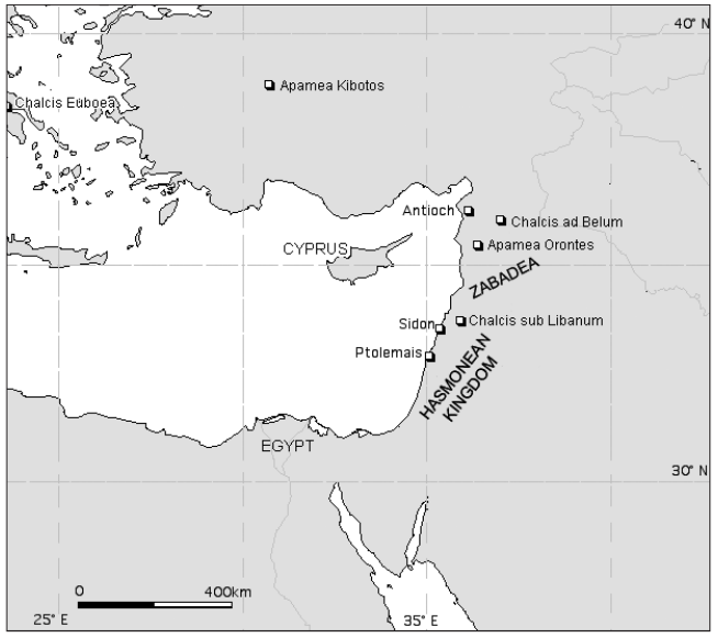
Chalcis sub
Libanum (thereafter Chalcis sL), present Anjar,
Ayn al Jarr, was in the Beqaa in Lebanon, about
10 km SE of present Baalbek, near Zabadea, a
narrow plain with present Zabadani, 25 km
NNW of Damascus and ancient Kaprazabadion
- present Qafr Zabad, 25 km SW of Chalcis sL
(Dussaud, 1927; Millar, 1987). (Karcz, 2004:767)
It seems less
probable, that the texts refer to Chalcis ad
Belum (thereafter Chalcis aB), present Hadir
and Kinnisrin in north Syria, less than 100 km
SE of Antioch (e.g., Pauly and Wissowa, 1899,
iii, c. 2078; Grainger, 1990, 1997; Barrington
Atlas, 2000). (Karcz, 2004:767-768)
2 Karcz (2004:767) places Beit Zabdai in Zabadea in Lebanon-Syria.
English translation of the Common Scholion from Karcz (2004)
... and when Janaeus came down to kill the scribes they escaped from him and went to Syria and stayed in country of Koselikos and the gentiles there rose to kill them and they
heziu them a great zia [shocked them a great shock, scared them great scare]
and they struck them a great blow and left some survivors and they went to Bet Zabadi1.
Rabbi Hidka
[2nd century CE] says the day the natives wanted to kill the scribes of Israel the sea upwelled and destroyed a third in the settled land.
Footnotes and Map
1 Karcz (2004:767) reports that consensus scholarship ascribes Bet Zabadi to
Zabadea in Lebanon-Syria.
Chronology
Karcz (2004) reports that the original quote in the
Megillat Taanit may, according to some Judaic scholars, refer to something that occurred during the rule of the more favorably viewed Hasmonean King
Jonathan Maccabeus (r. 160-142 BCE) while he was fighting King
Demetrius Nicator and the Arabs in Lebanon and Syria rather than, as stated in the Common Scholion, during the
rule of the notoriously cruel and oppressive Alexander Jannaeus (r. 103 - 76 BCE)2 while
he was pursuing Jewish Pharisaic rebels into Syria at the end of the
Judean Civil war. For this reason along with the apparent description of a tsunami,
Karcz (2004) suggested the possibility that this description may
refer to another earthquake such as the alleged Dead Fish and Soldiers Earthquake of ~142 BCE.
the gentiles there rose to kill them and they heziu them a great zia [shocked them a great shock, scared them great scare]
and they struck them a great blow and left some survivors and they went to Bet Zabadi
the sea upwelled and destroyed a third in the settled land
Locations
country of Belikos (probably Chalcis sub Libanum (about 10 km SE of Baalbek)
Marinner et al (2006) and
Carayon et al (2011) reported on
15 cores taken around the northern harbor and four around the cirque ronde.
There is no mention of tsunamogenic evidence in the cores. Marinner et al (2006:1521) noted that
in Unit B2 (Closed Phoenician to Roman harbours) persistent age-depth anomalies concur analogous data in Tyre’s ancient harbour where strong chronostratigraphic evidence for dredging has
been detailed from the Roman period onwards. This may indicate that, like at Tyre, any evidence of a 1st millennium BCE tsunami may have been removed by dredging.
Marriner et al (2005) undertook a litho and
biostratigraphical study of four core sequences from the landward edge of the current harbor. AMS radiocarbon dating was
performed on dateable material found in the cores. They attributed missing 1st millennium BCE strata to dredging activity
undertaken in the Roman and Byzantine periods.
Altunel et al (1999) claim evidence for
a ~80 BCE Apamea Earthquake
in Event 2 from their trenches but only two useful radiocarbon dates were obtained in their paleoseismic study. The date constraints
from these two samples are large (~1550 BCE - 1360 ± 50 CE) and their historical earthquake
assignment is speculative - based on consulting earthquake catalogs during that time span.
Gomez et. al. (2003:15)
may have seen evidence for an earthquake in the 1st or 2nd century BCE in Event B.
Event B is estimated to have created ~ 2 meters of left lateral strike slip displacement which translates to
an estimated Magnitude between 7.0 and 7.3 (7.0 and 7.2 according to
Gomez et al, 2003:16-17).
In terms of dating, an upper bound for Event B is 170 BCE - 20 CE while a lower bound for Events B and and the older Event C is from
1690 - 1400 BCE.
Elias et al (2007)
examined uplifted benches on the Lebanese coast between Sarafand and Tripolis; some in the vicinity of Tabarja
(~20 km. NE of Beirut). They identified four uplifts from 3 or more [sizeable Mw = ~7.5] earthquakes in
the past ca. 6-7 ka. They attributed the latest uplift (B1) to the 551 CE Beirut Quake while
the earlier events (B2, B3, and B4) were no more precisely dated than between ~5000 BCE and 551 CE. Bench uplift on the earlier events (B2, B3, and B4) would likely
have been due to uplift on the Mount Lebanon Thrust system - as was surmised for Event B1 and the
551 CE Beirut Quake.
If this earthquake occurred, it appears to have been located in Syria-Lebanon with distances to the Dead Sea Paleoseismic Sites varying from ~300-650 km. For a M = 7.0 earthquake, This results
in estimated PGAs varying from 0.04 - 0.11 g - below the 0.23 g threshold calculated by
Williams (2004)
or the 0.13 g threshold assumed in
Lu et al (2020a) that one needs to break the Dead Sea sediments. If one assumes M = 7.5 and the closest distance of ~300 km.,
PGA gets as high as 0.19 g.
At site ZA-2, Kagan et al (2011) observed a 8 cm. thick Type 4 intraclast breccia seismite
at a depth of 516 cm. with modeled ages of 103 BCE ± 37 (1σ) and 103 BCE ± 75 (2σ). They did not assign this seismite to any earthquake and suggested it struck in the middle of the
2nd century BCE. It may have formed during the southern Dead Fish and Soldiers Quake.
Klinger et. al. (2015) did not observe any seismic events whose time window
encompassed 92 BCE.
Location (with hotlink)
Status
Intensity
Notes
Dinar Trenches
Altunel et al (1999) claim evidence for
a ~80 BCE Apamea Earthquake
in Event 2 from their trenches but only two useful radiocarbon dates were obtained in their paleoseismic study. The date constraints
from these two samples are large (~1550 BCE - 1360 ± 50 CE) and their historical earthquake
assignment is speculative - based on consulting earthquake catalogs during that time span.
Tekieh Trenches
Gomez et. al. (2003:15)
may have seen evidence for an earthquake in the 1st or 2nd century BCE in Event B.
Event B is estimated to have created ~ 2 meters of left lateral strike slip displacement which translates to
an estimated Magnitude between 7.0 and 7.3 (7.0 and 7.2 according to
Gomez et al, 2003:16-17).
In terms of dating, an upper bound for Event B is 170 BCE - 20 CE while a lower bound for Events B and and the older Event C is from
1690 - 1400 BCE.
Tabarja Benches
Elias et al (2007)
examined uplifted benches on the Lebanese coast between Sarafand and Tripolis; some in the vicinity of Tabarja
(~20 km. NE of Beirut). They identified four uplifts from 3 or more [sizeable Mw = ~7.5] earthquakes in
the past ca. 6-7 ka. They attributed the latest uplift (B1) to the 551 CE Beirut Quake while
the earlier events (B2, B3, and B4) were no more precisely dated than between ~5000 BCE and 551 CE. Bench uplift on the earlier events (B2, B3, and B4) would likely
have been due to uplift on the Mount Lebanon Thrust system - as was surmised for Event B1 and the
551 CE Beirut Quake.
Migowski et. al. (2004) dated a 1 cm. thick Type 4 seismite at a depth of 294.93 cm. (2.9493 m) to 92 BCE.
Dead Sea - Nahal Ze 'elim
At site ZA-2, Kagan et al (2011) observed a 8 cm. thick Type 4 intraclast breccia seismite
at a depth of 516 cm. with modeled ages of 103 BCE ± 37 (1σ) and 103 BCE ± 75 (2σ). They did not assign this seismite to any earthquake and suggested it struck in the middle of the
2nd century BCE. It may have formed during the southern Dead Fish and Soldiers Quake.
Araba - Introduction
Araba - Taybeh Trench
LeFevre et al. (2018) did not observe any seismic events whose time window encompassed 92 BCE.
Araba - Qatar Trench
Klinger et. al. (2015) did not observe any seismic events whose time window
encompassed 92 BCE.
Notes
Earthquake from around this time in Apamea
Ambraseys (2009)
90 BC Apameia
A destructive earthquake in Phrygia, Asia Minor.
The earthquake happened before the expedition of
Mithridates VI (89–87 BC), who, when he arrived at
Apameia (Kibotos) during his invasion of Phrygia, found
the city ruined by an earthquake. Besides destroying
Apameia the earthquake caused ground deformations,
the appearance of new lakes and the disappearance of
rivers and springs. Mithridates gave funds for reconstruction to Apameia and to other towns, which had been
damaged by the earthquake. In places water gushed out
and spread over the country, carrying to the surface sea
fish and shells (sic.).
From palaeoseismicity data Altunel et al. (1999)
suggest that the event, which they date 80 BC, was associated with surface faulting of the Dinar zone.
Notes
‘Nicolaos of Damascus, in the one hundred and fourth book of
his Histories says that “near the Phrygian Apamea, during the
Mithridatic wars, earthquakes occurred which brought to light in
that country lakes never existent before; rivers also and springs
besides were opened by the earthquake, while many, again, disappeared; and such quantity of other water, of a brackish and
blue sort, gushed forth in their land, that in spite of its being a
great distance from the sea, the neighbouring region was filled
with shellfish and all the other fishes which the sea nurtures.”’
(Ath. Deipnos. VIII. 332/LCL. iv. 10).
‘And, among the other cities [of Phrygia], Apameia
was often shaken by earthquakes before the expedition of King
Mithridates, who, when he went over to that country and saw that
the city was in ruins, gave a hundred talents for its restoration; and
it is said that the same thing took place in the time of Alexander.’
(Str. XII. viii. 18/LCL. v. 514–516).
At the time of the war of Mithridates, after some earthquakes, there appeared near Apamea in Phrygia some lakes which did
not previously exist, as well as some rivers and some new springs, which came into being as a result of the movement
of the earth, while many others disappeared; and in the area when they were, there came to the surface such a quantity
of pale blue salt water that, it spite of the great distance from the sea, the surrounding area filled with shells an
the other fish which live in the sea.
For the identification of Apamea and the lake, see Robert (1962, pp.338ff.).
Strabo's evidence provides a better dating:
Amongst other cities, Apamea was ofter
struck by earthquakes before the expedition of Mithridates; and when he went there
and saw the damage, he gave one hundred talents for rebuilding.
This passage does not refer to a series of earthquakes, but merely points to earlier
seismic events in the history of Apamea. See entry (028) above. The entry of
Mithridates into Apamea is one of the first episodes of his first war (89-5 B.c.). An ex.
amination of the sources suggests a dating of 88 B.C. — the year in which he entered
Phrygia and expelled the Roman garrison from Apamea (see McGing 1986, p.109). It
is not possible to give an exact date for the earthquake, but it must have occurred in
the years immediately preceding this. Historians of Mithridates were concerned to
emphasise his commitment to rebuilding, and did so by pointing out that the city had
been helped in similar circumstances by Alexander the Great (see entry (028)), whom
Mithridates was evidently emulating. (In this connection, see App. Mithr. 101;
McGing 1986, p.101).